reservoir fluid (pvt) analysis · fluid analysis (pvt) equipment, loaned to the university of new...
TRANSCRIPT

BMR Research Newslener 3
A new pole path The recently completed study of late Mesozoic•
Cainozoic palaeomagnetism of Australia has iden•tified some of the sources of error in the Australian path. Having adopted an appropriate sampling scheme, we hope that these errors and some others - such as the inclination error in remanence to which sediments are prone - have been avoided in the new path (Fig.22). The new poles certainly agree with independent measurements on weath•ered profiles.
Further work remains to be done in order to consolidate the new path; indeed, some is already in progress to reduce the excessively large con•fidence circle for the late Tertiary pole, and preliminary measurements have been made to fill a large gap where poles are absent in the early Tertiary. Nevertheless, the new path, coupled with an improved understanding of past geomag•netic fields within Australia that has been derived from it, should lead to a considerable im•provement in dating Cainozoic weathering phen•omena.
For further information, contact Dr Mart Idnurm at BMR.
Reservoir fluid (PVT) analysis In BMR Research Newsletter I, a brief article
on enhanced oil recovery described how reservoir fluid analysis (PVT) equipment, loaned to the University of New South Wales by BMR, was being used for phase studies in carbon dioxide miscible displacement research.
In further co-operative research between the University and BMR, the PVT apparatus is also being used to analyse samples of oils and gas condensates. These are obtained from various petroleum productive reservoirs in Australia, gen•erally as either bottom-hole or surface separator samples.
The main purpose of these analyses is to provide basic volumetric, phase, and viscosity data of reservoir fluids. Not only will these data help us to analyse and understand petroleum production behaviour, particularly the recovery characteristics, but they will also enable us to make more precise assessments of Australia's recoverable reserves of petroleum.
The type of analysis carried out on a given sample depends on the character of the fluids as they exist in a reservoir; thus, significantly dif•ferent tests are conducted on oils and gas conden•sate systems. However, the equipment used for the two types of analyses is generally interchan•geable: the major difference is the type of 'visual cell' used for each analysis. This cell permits visual inspection of fluid phase characteristics during pressure-volume tests, and enables the bubble point of an oil or the dew point of a gas condensate to be viewed through a thick glass port in the cell. Tests are carried out at pressures and temperatures which range from subsurface re•servoir to surface separatorlstocktank conditions. Typical configurations of equipment used in these analyses are illustrated in figures 14, 15, and 20 of Kobayashi & Ruska (1958: The design of ex•periments for the study of petroleum fluids, Ruska Instrument Corporation, Houston, Texas, Publication 2302).
A typical PVT crude-oil testing program covers the following measurements:
14
• fluid compressibility, • fluid saturation pressure (bubble point), • gaS/oil ratios, • viscosity, • fluid density, • fluid characteristics under differential and
flash liberation processes from reservoir to stocktank, and
• component analyses of gases and liquids. More details from Mr Brian McKay, BMR.
October 1985
BMR's contribution to the Circum-Pacific Map Project BMR has been participating in the Circum- sedimentation rates' - all depicting the Pacific
Pacific Map Project since 1976. The project - basin at I: 17 000 000 scale - have also been whose headquarters are at USGS, Menlo Park, published. California - is producing an integrated series of The maps may be ordered from the AAPG maps of the Pacific basin showing the relationship Bookstore, P.O. Box 979, Tulsa, Oklahoma of geology, tectonism, and geophysics to known 74101, USA; all orders must be prepaid, and energy and mineral resources . There will even- prepayments must include the appropriate ship-tually be eight series of thematic maps at ping and handling charges (see below). The maps I: 10 000 000 scale, and selected compilations of that are currently available, and the cost of each in the entire basin at I: 17 000 000 scale (Fig. 23). US$, are:
Australia and Oceania are the major part of the southwest quadrant of the basin. BMR provides the panel chairman for this quadrant; he co- Complete set: ordinates data collection for and compilation of some of the maps. BMR has completed the southwest quadrant I: 10 000 000 'Geologic map' , which it prepared concurrently with compilation of the 'Tectonic map' by Dr Erwin Scheibner Northwest quadrant: (Geological Survey of New South Wales). Both maps should be published in time for the Fourth Circum-Pacific Conference, which will be held in Northeast quadrant: Singapore in August 1986.
At present BMR is compiling I: 10 000 000 mineral and energy resources maps, and aims to have drafts on display at the Conference. The 'Mineral resources map ' will be somthing better than a locality map, but not quite a metallogenic Southeast quadrant: map, as its background will be primarily lith-ologies associated with the occurrences. The occurrences of 40 commodities will be shown in three size ranges, which reflect production and Southwest quadrant: reserves; worked out mines will not be shown. The 'Energy resources map' deals with coal , oil shale, oil, and gas, and emphasises sedimentary basins. Antarctica region:
Other I: 10 000 OOO-scale thematic maps of the southwest quadrant have already been compiled and published by project headquarters; they are the Pacific basin sheet: 'Geographic' , 'Base', 'Plate tectonic' and 'Geodynamic' maps. Each of these themes, and also a 'Preliminary tectonostratigraphic terrane map' (to which Scheibner contributed) and a map of 'Manganese nodules, seafloor sediment, and
Geographic (6 maps; #836) Base (6 maps; #837) Plate tectonic (6 maps; #838) Geographic (#860) Base (#861) Plate tectonic (#874) Geographic (#862) Base (#863) Plate tectonic (#872) Geologic (#840) Mineral resources (#853) Geodynamic (#846) Geographic (#864) Base (#865) Plate tectonic (#873) Geodynamic (#847) Geographic (#866) Base (#867) Plate tectonic (#833) Geodynamic (#848) Geographic (#868) Base (#869) Plate tectonic (#834) Geographic (#870) Base (#871) Plate tectonic (#835) Manganese nodule! seafloor sediment (#859) Tectonostratigraphic terranes (#858)
Cost (UsS)
40 20
40 12 6
12 12 6
12 12
12 12 12 6
12 12 12 6
12 12 12 6
12 12 6
12
12
12
Fig, 23, Index map of the five 1:10 000 000 Circum-Pacific Map Project sheet areas; the edge of the Antarctica sheet area coincides with latitude 28°8. A I: 17 000 000 map covers the entire area shown.
October 1985
The air freight and handling charges for these maps sent to addresses outside North America are: If the order is:
less than US$ 10.00 to 20.00 to 40.00 to 60.00 to BO.OO to 100.00 to 120.00 to 140.00 to 160.00 to IBO.OO to
9:99 19.99 39.99 59.99 79.99 99.99
119.99 139.99 159.99 179.99 199.99
US:$ 6.00 12.00 24.00 36.00 4B .OO 60.00 72.00 B4.00 96.00
IOB .OO 120.00
200.00 and over contact AAPG The Australian Mineral Foundation is making
arrangements to stock and sell many of these maps. Enquiries should be addressed to the AMF Bookshop, Private Bag 97, Glenside, South Aus•tralia 5065; telephone (08) 797821.
For further information. contact Mr Fred. Doutch at BMR.
Crustal geophysics research in Europe
During a recent visit to Europe, Dr Mike Etheridge attended the biennial European Union of Geosciences (EUG) meeting at Strasbourg (France) and a conference on extension tectonics at Durham (UK). Papers presented at both meet•ings emphasised the important role of deep crustal seismic reflection profiling in developing models for the structure and evolution of the continental lithosphere.
Most western European countries are carrying out deep seismic profiling, either alone or in collaboration with their neighbours. Great Britain has a wholly marine program run by the BIRPS (British Institutions Reflection Profiling Syn•dicate) group, based largely in the British Geological Survey and Cambridge University. The results of the initial surveys off northwest Scotland have been published , and other surveys off the west coast of Britain and in the English Channel have been completed. Very extensive, gently dipping structures that extend from the surface to and even into the upper mantle have been imaged on many of these lines. A number of these structures correspond to the surface expres•sion of major Caledonide and Variscan thrusts. They appear to have been reactivated as normal faults that controlled the formation of Mesozoic to Tertiary half-grabens during the regional exten•sion that also gave rise to the North Sea basins.
Deep seismic profiling is at an earlier stage in continental Europe, where lines across most of the major tectonic features have been only recently completed or are about to be shot.
The most striking and widespread feature of all profiles presented at these meetings is a well•defined lower crustal layer up to 20 km thick. This layer is characterised by numerous horizontal to gently dipping discontinuous reflectors, and, where refraction has been carried out, compres•sional velocities in excess of 6 .8 km s·'. The reflectivity of the lower crustal layer is variously interpreted as being due to: I) numerous sill-like intrusions of mafic to
ultramafic rock, 2) tectonically induced layering formed by pen•
etrative stretching of the lower crust during one or more periods of extension, or
3) stacked supracrustals and infracrustals result•ing from one or more episodes of thrusting .
A number of papers presented at the conference on extension tectonics emphasised the similarity between structures in the Basin and Range Province (western USA) and those imaged on a number of seismic profiles across passive contin•ental margins and some sedimentary basins. The structures in the Basin and Range are dominated
BMR Research Newsletter 3
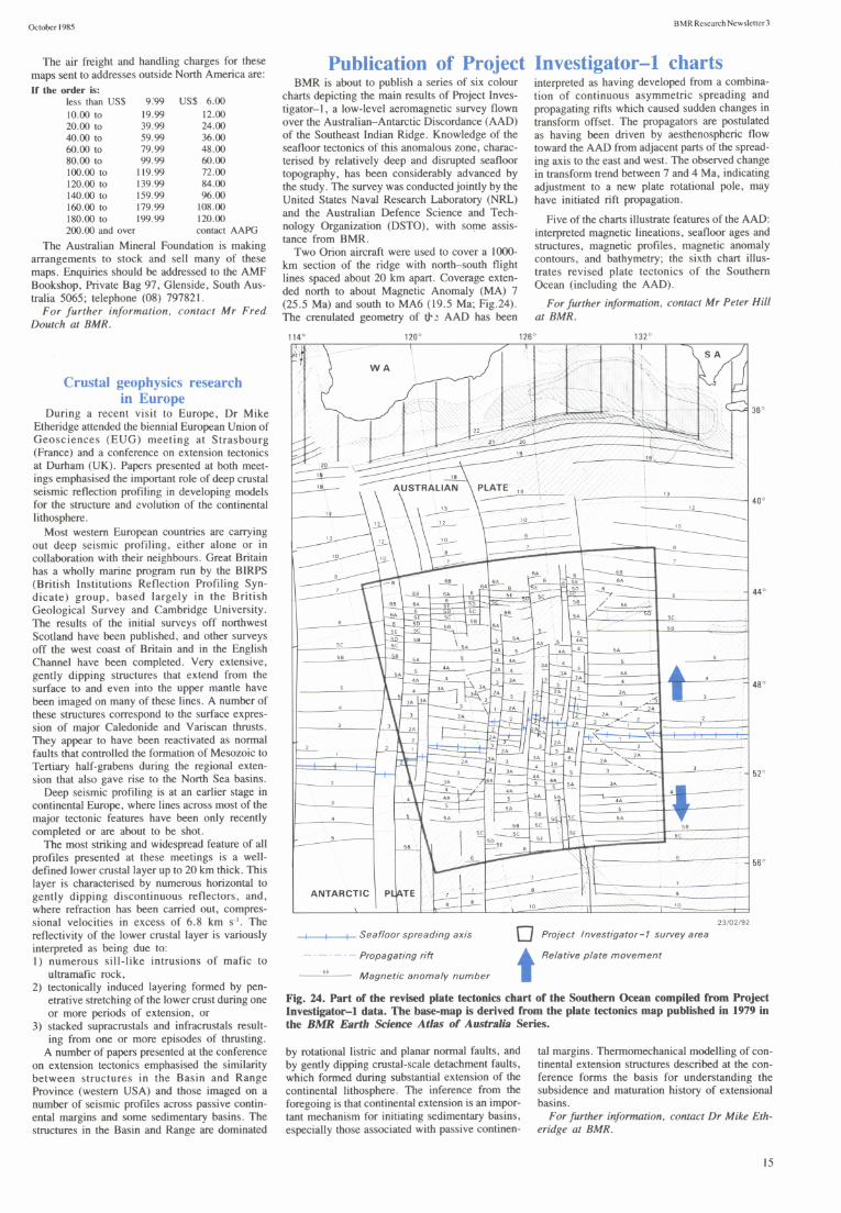
Publication of Project Investigator-l charts BMR is about to publish a series of six colour
charts depicting the main results of Project Inves•tigator-I, a low-level aeromagnetic survey flown over the Australian-Antarctic Discordance (AAD) of the Southeast Indian Ridge. Knowledge of the seafloor tectonics of this anomalous zone, charac•terised by relatively deep and disrupted seafloor topography, has been considerably advanced by the study. The survey was conducted jointly by the United States Naval Research Laboratory (NRL) and the Australian Defence Science and Tech•nology Organization (DSTO), with some assis•tance from BMR.
interpreted as having developed from a combina•tion of continuous asymmetric spreading and propagating rifts which caused sudden changes in transform offset. The propagators are postulated as having been driven by aesthenospheric flow toward the AAD from adjacent parts of the spread•ing axis to the east and west. The observed change in transform trend between 7 and 4 Ma, indicating adjustment to a new plate rotational pole, may have initiated rift propagation.
Two Orion aircraft were used to cover a 1000-km section of the ridge with north-south flight lines spaced about 20 km apart . Coverage exten•ded north to about Magnetic Anomaly (MA) 7 (25 .5 Ma) and south to MA6 (19.5 Ma; Fig.24) . The crenulated geometry of tJ' ~ AAD has been
Five of the charts illustrate features of the AAD: interpreted magnetic lineations, seafloor ages and structures, magnetic profiles, magnetic anomaly contours, and bathymetry; the sixth chart illus•trates revised plate tectonics of the Southern Ocean (including the AAD).
For further information. contact Mr Peter Hill at BMR.
t:::~ ~ V---'O
120 ' 126 ' 132 '
~ 18
~ J A\USTRALIAN p~--"",---;--- _-------".L3 --,,--_________...-----.J 40 ' : '~~-= ~ 10 10 7 +--~:;;; ... -r-!., ------8 6A 6 ~--'!_' __ -I 7 SA E 506---
68 6A 6 SE ~ ~ ~ -- 6 44° 68 6A 6 SO __ ~ /' -5::-E-.-~:-· t-------'--------1
, K H- /~~ -.!lA !joE =tF-c ~_ 5A . . ~ 5e
_---"~- .....6-. 0 58 58 5A r--r--~~--I-''''----------j ~~ F'- ~ 5 j----~ ___ -+__'5"'S _____ --4
5e 5e 58 \ 5A l-j .. J-~--~ ~~
\ ~ ~ ___ ~~ ~~ 3 :A .. -58 ~ :; SA 5 ~~ _ 1---'0"-A-Iw~0-+--"'5A'---'
~ .A~\ J JA .. 3~ 2A r---- 4 .,. .&.1'-----'0'-----=1 5 ----"'-- 3A 3A '"'-~ rft-I 2 • 48 '
----=------f\~ 0 3' ~ . , . 2 ~A ;:t 3A ~_ 4 JA JA 3 3 ~ , 1 2 -.1 . - 3.4
1-~----j.~ f--2- ~ ':A ~ ~' f'it-:~S2A ~/~.~~. 2~A F-~2 ~~ 3 J 2,\ t-- 2 2 ~ * 2A 2.' 1
t---L J-L=l 2A ' , - " 1 ~, r-L-, f-2- .x.: ' 3 J-2"---'- '-2. ~]A p3:~--:;:-' - -l---------
t-= L' 2A ':-+-I A rL~IL....:~~ 1 .
f----~-__i 11 2~ JAo 3 ~:-:- 4 211. ,,~ F ±=:::Jt=±==ff-+- ~ --, 1 ---:;-~1"-7--"-!0'-1....!.5.J-.---'-3 __ . ..:: .... :.::.:;+--!.----:-~ 52 '
2 I~"-.r-_"" "3A ------, 4"'" T 4...... JA
3 1-", }:-, _ ' .. .2- ~ f---""--~ _ O. .. \ 45" , ~ 5 _~, t~=',~A===r.I:___--== ,J SA . ~ ~~ F5~C ~~~~~~"'5'O'5A~~~~~~t~r-----
... ... 58
\ \ ~ 50----.l£.....~ "
~ ::::..sf 6
~~ '" ; "r---~-------=i 56 '
50
6
ANTARCTIC Pt.\ATE , - 7 l ; ~~. t=====:j===~ .~ 10
7
8
W
-+-+---;1- Seafloor spreading axis o 23/02/92
Project Investigator-l sUNeyarea
t . - Propagating rift Relative plate movement
Magnetic anomaly number
Fig. 24. Part of the revised plate tectonics chart of the Southern Ocean compiled from Project Investigator-I data. The base-map is derived from the plate tectonics map published in 1979 in the BMR Earth Science Atlas of Australia Series.
by rotational listric and planar normal faults, and by gently dipping crustal-scale detachment faults, which formed during substantial extension of the continental lithosphere. The inference from the foregoing is that continental extension is an impor•tant mechanism for initiating sedimentary basins, especially those associated with passive continen-
tal margins. Thermomechanical modelling of con•tinental extension structures described at the con•ference forms the basis for understanding the subsidence and maturation history of extensional basins.
For further information. contact Dr Mike Eth•eridge at BMR.
15