reservoir geology and geothermal potential of the … world geothermal congress 2015 melbourne,...
TRANSCRIPT

Proceedings World Geothermal Congress 2015
Melbourne, Australia, 19-25 April 2015
1
Reservoir Geology and Geothermal Potential of the Delft Sandstone Member in the West
Netherlands Basin
Marinus E. Donselaar1, Remco M. Groenenberg
1,2 and Douglas T. Gilding
3
Mailing address, 1Dept. of Geoscience and Engineering, Delft Univ. of Technology, P.O. Box 5048, 2600 GA Delft, the
Netherlands
2Present address: Akzo Nobel Industrial Chemicals B.V., 7554 RS Hengelo (OV), the Netherlands
3Statoil ASA, Mercurveien 88, Harstad, Norway
E-mail address, [email protected]
Keywords: Reservoir architecture, connectivity, geothermal doublets
ABSTRACT
The Delft Sandstone Member (DSSM) of the Lower Cretaceous Nieuwerkerk Formation in the West Netherlands Basin (WNB) is
the target of a technology demonstration project for deep geothermal energy production. A prerequisite for the optimal placement
of the geothermal well doublet is the assessment of the depositional setting of the target sandstone interval, and of the spatial
distribution, connectivity and internal permeability heterogeneity of the reservoir units therein. To achieve this, a study was done on
core, cuttings and well-log data from vintage oil exploration wells in and around the geothermal license area. Integration of the
analysis results with earlier studies on the regional geological setting and reprocessed PSDM 3D seismic data show that the DSSM
was deposited by a northwest-flowing meandering river system in a SE-NW oriented rift basin. The river deposits are subdivided in
three depositional units with varying reservoir properties. Unit 1 is sand-prone and comprises loosely-stacked single-storey
meandering river sandstone bodies embedded in a floodplain claystone and siltstone matrix. Unit 2 is a low net-to-gross succession
of interbedded claystone, siltstone and coal layers, formed in a wet floodplain and swamp environment. Unit 3 is sand-prone and
characterized by multi-storey and laterally-amalgamated meandering river sandstone bodies with minor mudstone floodplain
intervals. Based on the good porosity and permeability values and the high lateral and vertical sandstone-to-sandstone connectivity
this Unit 3 is considered the most promising target for the placement of geothermal doublets. The results will help broaden the
understanding of the reservoir heterogeneity and, hence, reduce uncertainty in geothermal energy projects which target the DSSM.
1. INTRODUCTION
Our present energy system based on fossil fuels is unsustainable because of predicted resource depletion and the large
environmental impact of greenhouse-gas emissions. This perception has triggered the research into clean, sustainable energy
sources and related reduction of greenhouse gas emissions. Deep geothermal energy production has the potential to become an
attractive complementary CO2-neutral energy source. Outstanding issues for a successful and cost-effective geothermal energy
production are, among others: (a) the impact of reservoir heterogeneity on total producible geothermal energy, (b) the depletion of
the heat source, and decrease of pressure and temperature related to overburden integrity and fault sealing issues, (c) prediction of
the total life time of a geothermal reservoir, and (d) scaling and corrosion of production wells.
The Delft Geothermal Project (DAP) was launched as a demonstration project for solutions to technical challenges posed by the
cost-effective development of geothermal systems. The project was initiated in 2007 by students, staff, and alumni of the
Department of Geoscience and Engineering at the Delft University of Technology, and evolved into a consortium of governmental
and industrial partners. The project aims to: (1) build a geothermal system that serves as an energy production facility for heating
offices and student houses on the university campus, (2) provide a technology demonstration case for innovative lightweight
composite drilling technology, and (3) develop a geothermal research facility.
In 2009, the University was granted an exploration and production license for geothermal energy by the government (Fig. 1). In the
60 km2 license area two geothermal systems owned by glasshouse farmers are operational since 2010 (Fig. 2, wells PNA-GT-01
and PNA-GT-02). Both systems produce water with a temperature of 70 °C from the Delft Sandstone Member (DSSM), which is a
Lower Cretaceous (Valanginian) fluvial sandstone formation in the West-Netherlands Basin (WNB). First experiences with the
systems indicate that the performance of the geothermal doublets is highly variable. A geothermal doublet comprises a production
well for hot water and a re-injection well for the produced and cooled-down water (Figs. 2-3). Both wells are in the same aquifer.
The cooled-down water radiates away from the injection well and flows back to the production well. Knowledge of reservoir
connectivity between the production and the injection well in the aquifer is therefore essential. However, the targeted fluvial
sandstones are highly heterogeneous, and connectivity between individual sandstone bodies over typical doublet distances (1-2 km)
is uncertain. Drilling of the two operational geothermal systems in the license area was based on feasibility studies in which well-
log and core data were used from nearby oil and gas fields (Delft, Rijswijk, Pijnacker, Moerkapelle, Berkel; Fig. 1). In addition,
earlier studies were used to assess the general geological setting of the WNB (Fig. 4; Den Hartog Jager, 1996; Racero-Baena and
Drake, 1996; DeVault and Jeremiah, 2002; Jeremiah et al., 2010). However, the oil and gas wells are all located on structural highs
in the subsurface, whereas the geothermal wells target the structural lows. In view of the complex, highly variable basin-fill history
of the WNB, considerable geological uncertainty is involved in extrapolating subsurface data from the highs to the lows. This
specifically concerns the uncertainty associated with the presence and continuity of permeable sandstone in the target aquifer. To
reduce this uncertainty, a reservoir characterization study of the DSSM was carried out to assess the spatial distribution of fluvial
sandstone bodies, their connectivity and internal permeability heterogeneity. For the present study well-logs, cores and cuttings
from wells in the license area and the Moerkapelle area (10 km to the northeast) were re-evaluated, and the results combined with

Donselaar et al.
2
re-processed, pre-stack depth-migrated 3D seismic data. In this paper, the results of this study and their implications for geothermal
energy production from the DSSM are discussed.
Figure 1: Oil (red) and gas (green) fields in the West Netherlands Basin. Black stars: location of oil wells (DEL-03 and
MKP-11) used in this study. Blue stars: location of geothermal wells started in 2010; HAG-GT-01, HAG-GT-02 (The
Hague; city heating); PNA-GT-01 (Pijnacker; greenhouse heating). Box: study area. Modified from: www.nlog.nl.
Figure 2: 3D structural model of the DSSM in the study area with trajectories of the planned TU Delft geothermal wells.
Wells PNA-GT-01 and PNA-GT-02: producing geothermal doublets.
2. GEOLOGICAL SETTING
The DSSM is part of the Nieuwerkerk Formation and consists of a fluvial succession formed during and after a major Early
Cretaceous rifting phase in the WNB. The WNB is a 60-km-wide transtensional basin in the southwest of the Netherlands and the
adjacent offshore area and comprises a series of NW-SE trending structural highs and depressions (Fig. 4; Ziegler, 1990). Rifting
occurred in several pulses of short duration in the time-span from Kimmeridgian (155 Ma) to Barremian (130 Ma) and the basin
was filled syn-tectonically with fluvial sediment. Active rifting decreased in the Hauterivian (135 Ma) and the basin entered a post-
rift sag phase. Continued subsidence led to marine transgression, and most of the post-Hauterivian sediments were deposited in a
marine setting. The WNB gradually subsided, until the Late Cretaceous Laramide compressional phase started a period of inversion
and uplift (Van Wijhe 1987, Den Hartog Jager, 1996). On seismic data, major fault zones display reverse offsets, indicating that
older basin-bounding faults were reactivated. Many of the oil-bearing structures (e.g., the pop-up structure that contains the
Pijnacker oilfield; Fig. 5) have been formed during this phase (De Jager et al. 1996; Racero Baena and Drake 1996).
2.1 Stratigraphy
The Nieuwerkerk Formation (Fig. 6) consists, from base to top, of the Alblasserdam Member, the DSSM, and the Rodenrijs
Claystone Member. The sedimentology of the three members of the Nieuwerkerk Formation has been described by Van Adrichem
Boogaert and Kouwe (1993), Den Hartog Jager (1996), DeVault and Jeremiah (2002) and Jeremiah et al. (2010) and is based on
core descriptions and gamma-ray logs, complemented with palynological and fossil assemblage data. The present sedimentological
Donselaar et al.
3
description is based on the work of these authors, complemented with results from our analysis of cuttings samples from well DEL-
03 in the license area, and on core analysis of the DSSM in the oil exploration well MKP-11 in the Moerkapelle field, 10 km
northeast of the license area.
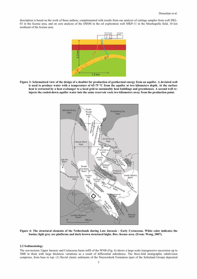
Figure 3: Schematized view of the design of a doublet for production of geothermal energy from an aquifer. A deviated well
is used to produce water with a temperature of 65-75 °C from the aquifer at two kilometers depth. At the surface
heat is extracted by a heat exchanger to a local grid to sustainably heat buildings and greenhouses. A second well re-
injects the cooled-down aquifer water into the same reservoir rock two kilometers away from the production point.
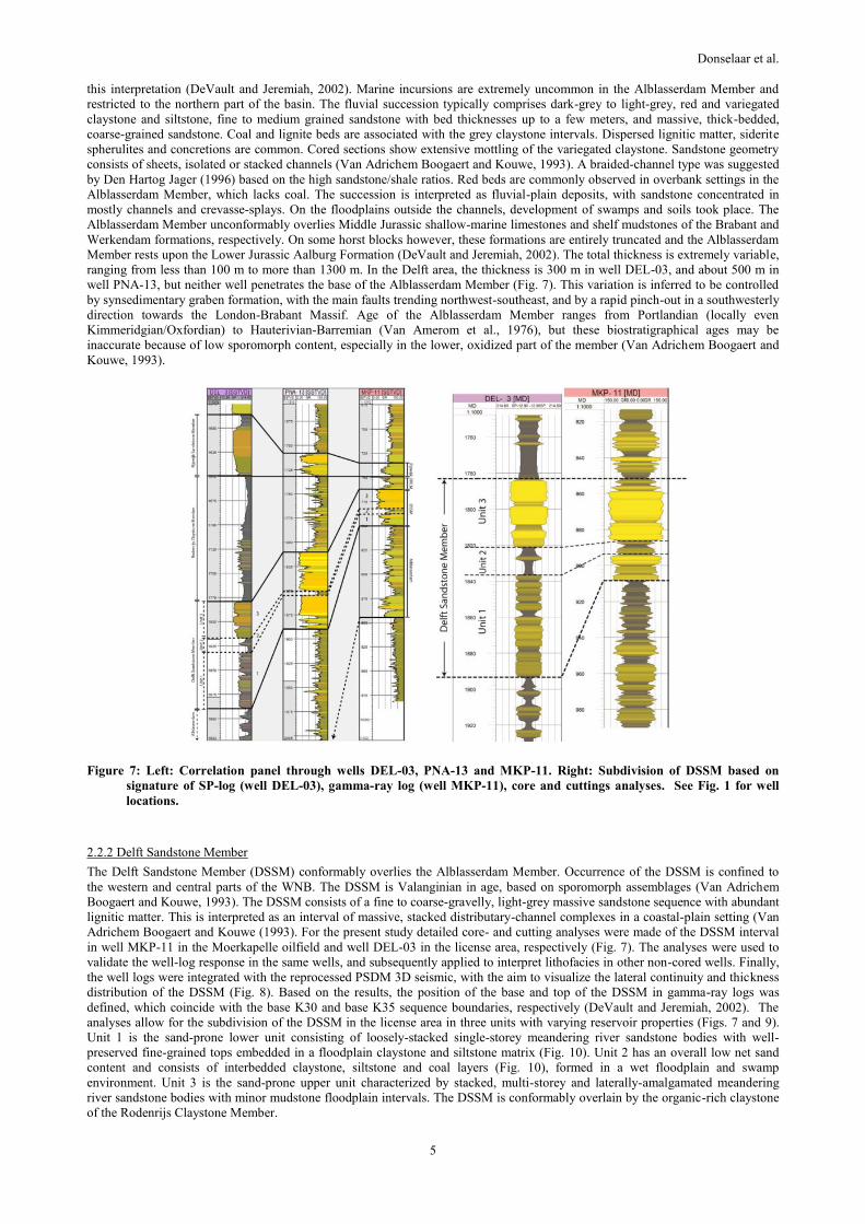
Figure 4: The structural elements of the Netherlands during Late Jurassic - Early Cretaceous. White color indicates the
basins; light grey are platforms and dark brown structural highs. Box: license area. (From: Wong, 2007).
2.2 Sedimentology
The syn-tectonic Upper Jurassic and Cretaceous basin infill of the WNB (Fig. 6) shows a large-scale transgressive succession up to
3000 m thick with large thickness variations as a result of differential subsidence. The three-fold stratigraphic subdivision
comprises, from base to top: (1) fluvial clastic sediments of the Nieuwerkerk Formation (part of the Schieland Group) deposited

Donselaar et al.
4
during the Kimmerian rift phase; (2) marine clastics of the Rijnland Group deposited during the post-rift sag phase, and (3) pelagic
carbonates of the Chalk Group (Van Adrichem Boogaert and Kouwe, 1993; Den Hartog Jager, 1996). Good-quality geothermal
aquifers are found in the DSSM, and also in the Vlieland Sandstone/Claystone Formation (Rijswijk Sandstone Member, Berkel
Sandstone Member) which forms the basal sandy part of the Rijnland Group. Focus of the present study is on the DSSM, the
primary target for geothermal energy production on the license area.
Figure 5: Depth-converted seismic cross-section (depth in m) through the license area shows the horst and graben
configuration of the WNB that was later accentuated by inversion. The DSSM sits in a gentle, broad syncline
bounded by the Delft High and the Pijnacker High. Note the subtle thickness difference in the DSSM.
Figure 6: Stratigraphy of the license area. Lithology based on wells DEL-3, DEL-8, PNA-13, PNA-15 and RWK-1. Names of
groups, formations and members, and legends based on Van Adrichem Boogaert and Kouwe (1993). Latitude and
temperature data after Verweij and Simmelink (2001). Sequences and eustatic sea level curve after Haq et al. (1988).
Brown line: Stratigraphic position DSSM.
2.2.1 Alblasserdam Member
The Alblasserdam Member is present throughout the WNB. The available well-log data and scarce cores indicate that the Member
is entirely made up of fluvial deposits. Biostratigraphic data consisting of sporomorph-dominated continental assemblages support
Donselaar et al.
5
this interpretation (DeVault and Jeremiah, 2002). Marine incursions are extremely uncommon in the Alblasserdam Member and
restricted to the northern part of the basin. The fluvial succession typically comprises dark-grey to light-grey, red and variegated
claystone and siltstone, fine to medium grained sandstone with bed thicknesses up to a few meters, and massive, thick-bedded,
coarse-grained sandstone. Coal and lignite beds are associated with the grey claystone intervals. Dispersed lignitic matter, siderite
spherulites and concretions are common. Cored sections show extensive mottling of the variegated claystone. Sandstone geometry
consists of sheets, isolated or stacked channels (Van Adrichem Boogaert and Kouwe, 1993). A braided-channel type was suggested
by Den Hartog Jager (1996) based on the high sandstone/shale ratios. Red beds are commonly observed in overbank settings in the
Alblasserdam Member, which lacks coal. The succession is interpreted as fluvial-plain deposits, with sandstone concentrated in
mostly channels and crevasse-splays. On the floodplains outside the channels, development of swamps and soils took place. The
Alblasserdam Member unconformably overlies Middle Jurassic shallow-marine limestones and shelf mudstones of the Brabant and
Werkendam formations, respectively. On some horst blocks however, these formations are entirely truncated and the Alblasserdam
Member rests upon the Lower Jurassic Aalburg Formation (DeVault and Jeremiah, 2002). The total thickness is extremely variable,
ranging from less than 100 m to more than 1300 m. In the Delft area, the thickness is 300 m in well DEL-03, and about 500 m in
well PNA-13, but neither well penetrates the base of the Alblasserdam Member (Fig. 7). This variation is inferred to be controlled
by synsedimentary graben formation, with the main faults trending northwest-southeast, and by a rapid pinch-out in a southwesterly
direction towards the London-Brabant Massif. Age of the Alblasserdam Member ranges from Portlandian (locally even
Kimmeridgian/Oxfordian) to Hauterivian-Barremian (Van Amerom et al., 1976), but these biostratigraphical ages may be
inaccurate because of low sporomorph content, especially in the lower, oxidized part of the member (Van Adrichem Boogaert and
Kouwe, 1993).
Figure 7: Left: Correlation panel through wells DEL-03, PNA-13 and MKP-11. Right: Subdivision of DSSM based on
signature of SP-log (well DEL-03), gamma-ray log (well MKP-11), core and cuttings analyses. See Fig. 1 for well
locations.
2.2.2 Delft Sandstone Member
The Delft Sandstone Member (DSSM) conformably overlies the Alblasserdam Member. Occurrence of the DSSM is confined to
the western and central parts of the WNB. The DSSM is Valanginian in age, based on sporomorph assemblages (Van Adrichem
Boogaert and Kouwe, 1993). The DSSM consists of a fine to coarse-gravelly, light-grey massive sandstone sequence with abundant
lignitic matter. This is interpreted as an interval of massive, stacked distributary-channel complexes in a coastal-plain setting (Van
Adrichem Boogaert and Kouwe (1993). For the present study detailed core- and cutting analyses were made of the DSSM interval
in well MKP-11 in the Moerkapelle oilfield and well DEL-03 in the license area, respectively (Fig. 7). The analyses were used to
validate the well-log response in the same wells, and subsequently applied to interpret lithofacies in other non-cored wells. Finally,
the well logs were integrated with the reprocessed PSDM 3D seismic, with the aim to visualize the lateral continuity and thickness
distribution of the DSSM (Fig. 8). Based on the results, the position of the base and top of the DSSM in gamma-ray logs was
defined, which coincide with the base K30 and base K35 sequence boundaries, respectively (DeVault and Jeremiah, 2002). The
analyses allow for the subdivision of the DSSM in the license area in three units with varying reservoir properties (Figs. 7 and 9).
Unit 1 is the sand-prone lower unit consisting of loosely-stacked single-storey meandering river sandstone bodies with well-
preserved fine-grained tops embedded in a floodplain claystone and siltstone matrix (Fig. 10). Unit 2 has an overall low net sand
content and consists of interbedded claystone, siltstone and coal layers (Fig. 10), formed in a wet floodplain and swamp
environment. Unit 3 is the sand-prone upper unit characterized by stacked, multi-storey and laterally-amalgamated meandering
river sandstone bodies with minor mudstone floodplain intervals. The DSSM is conformably overlain by the organic-rich claystone
of the Rodenrijs Claystone Member.

Donselaar et al.
6
Figure 8: Depth contour map of top DSSM with main structural elements. Map constructed from PSDM and regional time
seismic. SW-NE line is location of seismic section in Fig. 5.
Figure 9: Gamma-ray log signature, facies description and interpreted depositional architecture of the three units in the
DSSM.
2.2.3 Rodenrijs Claystone Member
The Rodenrijs Claystone Member consists of grey lignitic claystone, siltstone and sandstone, characterized by laminated or
contorted bedding and lignite/coal beds with well-preserved plant fossils (Van Adrichem Boogaert and Kouwe, 1993). Locally
mollusc shells are present. Siderite spherulites and concretions are common. The Rodenrijs Claystone Member shows a
characteristic serrate pattern on wireline logs. Core data from the Rotterdam area exhibit fining-upward successions from stacked,
cross-bedded fluvial channel sandstone to flood-plain mudstone with occasional crevasse-splay deposits. The fining-upward
sequence is capped by coal or thin lacustrine strata. Continued relative sea level rise culminated in lagoonal deposits. Stacked
fluvial channel systems with fining-upward sequences and bases eroding flood-plain deposits are also recorded. The predominance
of poorly drained flood-plain deposits, crevasse splays, and minor stacked channel deposits suggest a meandering fluvial system
(Den Hartog Jager, 1996). Like the DSSM, its distribution is confined to the western and central parts of the WNB. Age of the
Rodenrijs Claystone Member is Late Valanginian to Early Hauterivian based on sporomorph analysis (Van Adrichem Boogaert and
Kouwe, 1993). A lower-coastal-plain to lagoonal depositional environment is inferred. This proximity to the sea suggests that
fining-upward sequences (themselves composed of stacked channel/overbank deposits) are closely linked to relative sea level rise.
2.3 Depositional Model of the DSSM
The lithofacies succession in the license area and surrounding area is primarily controlled by the rate of accommodation
development vs. sediment accumulation during synsedimentary tectonic movement along faults that separated the areas southwest
of the Delft High and northeast of the Pijnacker High from the low area (Vrijenban Syncline) between the highs (Figs. 2, 5, 8).

Donselaar et al.
7
Deposition of DSSM Unit 1 was controlled by differential movement along these faults in combination with a rising sea level, i.e.,
a high rate of accommodation increase which favored the deposition of loosely-stacked, fluvial sandstone bodies with well-
preserved fine-grained tops embedded in floodplain fines (Fig. 9). This setting implies low connectivity of the fluvial sandstone
bodies. The thickness of Unit 1 increases towards the NE flank of the Delft High (Fig. 7), which reflects the synsedimentary
activity of this fault during the deposition of Unit 1.
Figure 10: Core photos of the DSSM in well MKP-11. A: Light-grey floodplain siltstone. B: Erosional contact between
floodplain siltstone and medium-grained fluvial channel sandstone. Note coal fragments as lag deposit. C: Oil-
stained fine to medium-grained fluvial sandstone. D: Oil-stained coarse-grained fluvial sandstone with lighter mud-
invasion rim. E: Coal and siltstone laminae; top of fluvial sandstone. F: Erosional contact between grey floodplain
siltstone and medium-grained fluvial channel sandstone with coal fragments.
Continued relative sea level rise during deposition of Unit 2 led to temporal paucity of coarser-grained fluvial sediment supply to
the area, and to deposition of extensive fine-grained floodplain and swamp sediments. Hence, net sand content of Unit 2 is very
low, and excludes this unit as a target for geothermal energy production.
Relative sea level rise decreased during deposition of Unit 3, and led to the deposition of laterally-amalgamated and vertically-
stacked fluvial sandstone bodies (Fig. 9). A cross-section through wells MKP-11, PNA-13, and DEL-03 (Fig. 7) shows a rather
constant thickness throughout the correlation panel, which reflects that differences in accommodation space were small. The high
sand-to-shale ratio and high sandstone connectivity resulted from repeated truncation of fluvial channels into fine-grained
sandstone tops and floodplain mudstone in an environment of low accommodation increase. The depositional model resulting from
integration of all analysis results shows the sedimentary architecture of the DSSM in the study area (Fig. 11).
Donselaar et al.
8
Figure 11: Depositional model for the DSSM in the study area based on analyses of well-logs, cuttings, cores, and on seismic
interpretation of fault-conditioned thickness differentiation.
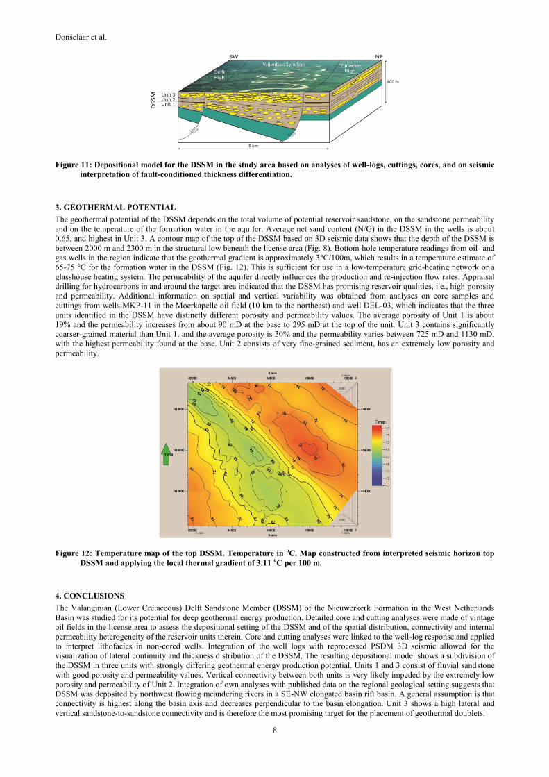
3. GEOTHERMAL POTENTIAL
The geothermal potential of the DSSM depends on the total volume of potential reservoir sandstone, on the sandstone permeability
and on the temperature of the formation water in the aquifer. Average net sand content (N/G) in the DSSM in the wells is about
0.65, and highest in Unit 3. A contour map of the top of the DSSM based on 3D seismic data shows that the depth of the DSSM is
between 2000 m and 2300 m in the structural low beneath the license area (Fig. 8). Bottom-hole temperature readings from oil- and
gas wells in the region indicate that the geothermal gradient is approximately 3°C/100m, which results in a temperature estimate of
65-75 °C for the formation water in the DSSM (Fig. 12). This is sufficient for use in a low-temperature grid-heating network or a
glasshouse heating system. The permeability of the aquifer directly influences the production and re-injection flow rates. Appraisal
drilling for hydrocarbons in and around the target area indicated that the DSSM has promising reservoir qualities, i.e., high porosity
and permeability. Additional information on spatial and vertical variability was obtained from analyses on core samples and
cuttings from wells MKP-11 in the Moerkapelle oil field (10 km to the northeast) and well DEL-03, which indicates that the three
units identified in the DSSM have distinctly different porosity and permeability values. The average porosity of Unit 1 is about
19% and the permeability increases from about 90 mD at the base to 295 mD at the top of the unit. Unit 3 contains significantly
coarser-grained material than Unit 1, and the average porosity is 30% and the permeability varies between 725 mD and 1130 mD,
with the highest permeability found at the base. Unit 2 consists of very fine-grained sediment, has an extremely low porosity and
permeability.
Figure 12: Temperature map of the top DSSM. Temperature in oC. Map constructed from interpreted seismic horizon top
DSSM and applying the local thermal gradient of 3.11 oC per 100 m.
4. CONCLUSIONS
The Valanginian (Lower Cretaceous) Delft Sandstone Member (DSSM) of the Nieuwerkerk Formation in the West Netherlands
Basin was studied for its potential for deep geothermal energy production. Detailed core and cutting analyses were made of vintage
oil fields in the license area to assess the depositional setting of the DSSM and of the spatial distribution, connectivity and internal
permeability heterogeneity of the reservoir units therein. Core and cutting analyses were linked to the well-log response and applied
to interpret lithofacies in non-cored wells. Integration of the well logs with reprocessed PSDM 3D seismic allowed for the
visualization of lateral continuity and thickness distribution of the DSSM. The resulting depositional model shows a subdivision of
the DSSM in three units with strongly differing geothermal energy production potential. Units 1 and 3 consist of fluvial sandstone
with good porosity and permeability values. Vertical connectivity between both units is very likely impeded by the extremely low
porosity and permeability of Unit 2. Integration of own analyses with published data on the regional geological setting suggests that
DSSM was deposited by northwest flowing meandering rivers in a SE-NW elongated basin rift basin. A general assumption is that
connectivity is highest along the basin axis and decreases perpendicular to the basin elongation. Unit 3 shows a high lateral and
vertical sandstone-to-sandstone connectivity and is therefore the most promising target for the placement of geothermal doublets.

Donselaar et al.
9
ACKNOWLEDGEMENTS
The Delft Geothermal Project is under performance of a consortium of share- and stakeholders. We kindly thank them for their
support. We thank the Nederlandse Aardolie Maatschappij (NAM) for provision of the seismic data of the West Netherlands Basin,
and for access to core and cuttings, PanTerra Geoconsultants for assistance with the cuttings analysis, and Schlumberger for the use
of Petrel™. MSc and BSc students Claartje Wiggers, Mark Loerakker, Andrina Drost, Ko Korenromp and Peter Smits are
acknowledged for their contributions in the lithofacies analysis. David Brethaut prepared the contour map of the DSSM.
REFERENCES
Betz, D., Führer, F., Greiner, G. and Plein, E.: Evolution of the Lower Saxony basin, Tectonophysics, 137, (1987), 127-170.
De Jager, J.: Geological development, In: Wong, Th. E., Batjes, D.A.J. and De Jager, J. (eds): Geology of the Netherlands. Royal
Netherlands Academy of Arts and Sciences (Amsterdam), (2007), 5–26.
Den Hartog Jager, D.G.: Fluviomarine sequences in the Lower Cretaceous of the West Netherlands Basin: correlation and seismic
expression, In: Rondeel, H.E., Batjes, D.A.J. and Nieuwenhuijs, W.H. (eds): Geology of Gas and Oil under the Netherlands.
Kluwer (Dordrecht), (1996), 229–242.
DeVault, B. and Jeremiah, J.: Tectonostratigraphy of the Nieuwerkerk Formation (Delfland Subgroup), West Netherlands Basin,
American Association of Petroleum Geologists Bulletin, 86, (2002), 1679–1707.
Jeremiah, J.M., Duxbury, S. and Rawson, P.: Lower Cretaceous of the southern North Sea Basins: reservoir distribution within a
sequence stratigraphic framework, Netherlands Journal of Geosciences, 89, (2010), 203 – 237.
Haq, B.U., Hardenbol, J. and Vail, P.R.: Mesozoic and Cenozoic chronostratigraphy and cycles of sea-level change, In: Wilgus,
C.K., Hastings, B.S., Kendall, C.G.S.C., Posamentier, H.W., Ross, C.A. and Van Wagoner, J.C. (eds.): Sea-level changes - An
integrated approach, p. 71-108 - Soc. of Economic Paleontologists and Mineralogists, Special Publ., 42, (1988).
Racero-Baena, A. and Drake, S.J.: Structural style and reservoir development in the West Netherlands oil province, In: Rondeel,
H.E., Batjes, D.A.J. and Nieuwenhuijs, W.H. (eds), Geology of Gas and Oil under the Netherlands, Kluwer (Dordrecht), (1996)
211–228.
Van Adrichem Boogaert, H.A., and Kouwe,W.F.P.: Stratigraphic nomenclature of the Netherlands, revision and update by RGD
and NOGEPA, Mededelingen Rijks Geologische Dienst, Section A, General, 50, (1993), 25.
Van Amerom, H. W. J., Herngreen, G. F. W., and Romein, B. J.: Palaeobotanical and palynological investigation with notes on the
microfauna of some core samples from the Lower Cretaceous of the West Netherlands Basin, Mededelingen Rijks Geologische
Dienst NS, 27 (2), (1976), 41-79.
Van Wijhe, D.H.: Structural evolution of inverted basins in the Dutch offshore, Tectonophysics, 137, (1987), 171-219.
Verweij, J.M., and Simmelink, H.J.: Geodynamic and hydrodynamic evolution of the Broad Fourteens Basin (Netherlands) in
relation to its petroleum systems, Marine and Petroleum Geology, Elsevier, 19, (2002), 339-359
Wolf, K-H.A.A., Willemsen, A., Bakker, T.W., Wever, A.K.T. and Gilding, D.T.: The development of a multi-purpose geothermal
site in an urban area, Conference paper presented at the SPE-70th EAGE Conference and Exhibition, Rome, Italy, (2008),
1018–1022.
Wong, Th. E.: Jurassic. In: Th. E. Wong, D. A. J. Batjes, and J. De Jager, eds., Geology of the Netherlands: Amsterdam, Royal
Netherlands Academy of Arts and Sciences, (2007), 107-125.
Ziegler, P.A.: Geological atlas of western and central Europe, part 2, Geological Society Publishing House (Bath), (1990), 239.