reservoir management - ice bookshop · reservoir management. copyrighted material. do not...
TRANSCRIPT

Reservoir Management
Edited by Andrew PepperA T Pepper Engineering Consultancy Ltd, UK

at ungauged sites. The FEH catchment descriptors are derived from a 50 m digital
elevation model used in combination with a number of digital maps of, for example,
annual average rainfall. The boundary of the catchment draining to any individual point
on the digital river network can be identified, allowing average descriptor values to be
calculated for over four million individual catchments.
The FEH catchment descriptors include catchment area, mean drainage path length and
slope, mean altitude and the standard percentage runoff from the soil types. The rainfall
database holds modelled depth–duration–frequency relationships for every 1 km
Ordnance Survey grid point in the UK; when this is combined with model parameters
estimated from catchment descriptors, FEH methods can produce estimated peak flows
and hydrographs for a point on any watercourse in the UK.
Figure 3.4 shows the output from the revitalised flood hydrograph (ReFH) model, which
uses FEH data to simulate river flow resulting from a storm of specified duration and
probability, termed a ‘design storm’, on the catchment. The rainfall pattern from the
design storm is shown, as is the much lower net rainfall derived from the ReFH model
of the catchment hydrology. A gradually rising baseflow is shown, as well as the flow
hydrograph with and without the baseflow.
Rapid assessment methodA preliminary screening method of estimating peak flood inflows was developed before
flood estimation software was generally available. For that reason, the Flood Estimation
Figure 3.4 Output from ReFH model of catchment hydrology
0.00
0.20
0.40
0.60
0.80
1.00
1.20
0
2
4
6
8
10
12
0.00 0.25 0.50 0.75 1.00 1.25 1.50 1.75 2.00
Flow
: m3 /s
Rain
fall:
mm
Time: h
ReFH model output
Rainfall Net rainfall Total flow Direct runoff Baseflow
50
Reservoir Management
COPYRIGHTED M
ATERIAL. DO N
OT DISTRIBUTE
The temperature of shallow depths of water can vary relatively quickly. A greater depth
of water will provide more suitable habitats for a range of fish and other aquatic
creatures.
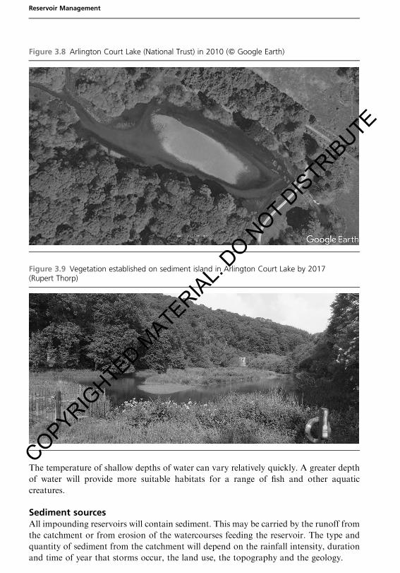
Sediment sourcesAll impounding reservoirs will contain sediment. This may be carried by the runoff from
the catchment or from erosion of the watercourses feeding the reservoir. The type and
quantity of sediment from the catchment will depend on the rainfall intensity, duration
and time of year that storms occur, the land use, the topography and the geology.
Figure 3.8 Arlington Court Lake (National Trust) in 2010 (# Google Earth)
Figure 3.9 Vegetation established on sediment island in Arlington Court Lake by 2017(Rupert Thorp)
64
Reservoir Management
COPYRIGHTED M
ATERIAL. DO N
OT DISTRIBUTE
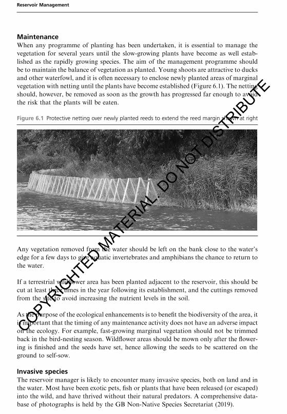
MaintenanceWhen any programme of planting has been undertaken, it is essential to manage the
vegetation for several years until the slow-growing plants have become as well estab-
lished as the rapidly growing species. The aim of the management programme should
be to maintain the balance of vegetation as planted. Young shoots are attractive to ducks
and other waterfowl, and it is often necessary to enclose newly planted areas of marginal
vegetation with netting until the plants have become established (Figure 6.1). The netting
should, however, be removed as soon as the growth has progressed far enough to avoid
the risk that the plants will be eaten.
Any vegetation removed from the water should be left on the bank close to the water’s
edge for a few days to give aquatic invertebrates and amphibians the chance to return to
the water.
If a terrestrial wildflower area has been planted adjacent to the reservoir, this should be
cut at least three times in the year following its establishment, and the cuttings removed
from the site to avoid increasing the nutrient levels in the soil.
As the purpose of the ecological enhancements is to benefit the biodiversity of the area, it
is important that the timing of any maintenance activity does not have an adverse impact
on the ecology. For example, fast-growing marginal vegetation should not be trimmed
back in the bird-nesting season. Wildflower areas should be mown only after the flower-
ing is finished and the seeds have set, hence allowing the seeds to be scattered on the
ground to self-sow.
Invasive speciesThe reservoir manager is likely to encounter many invasive species, both on land and in
the water. Most have been exotic pets, fish or plants that have been released (or escaped)
into the wild, and have thrived without their natural predators. A comprehensive data-
base of photographs is held by the GB Non-Native Species Secretariat (2019).
Figure 6.1 Protective netting over newly planted reeds to extend the reed margin shown at right
154
Reservoir Management
COPYRIGHTED M
ATERIAL. DO N
OT DISTRIBUTE
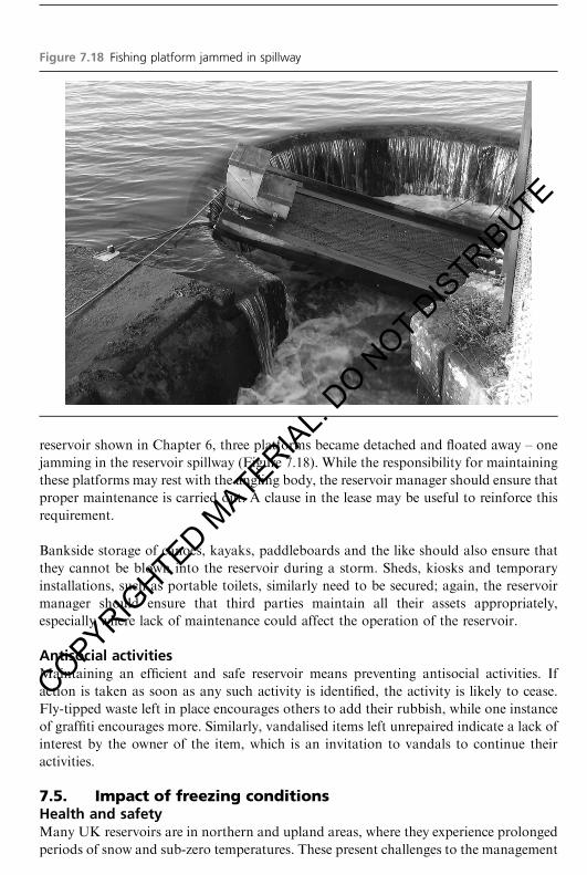
reservoir shown in Chapter 6, three platforms became detached and floated away – one
jamming in the reservoir spillway (Figure 7.18). While the responsibility for maintaining
these platforms may rest with the angling body, the reservoir manager should ensure that
proper maintenance is carried out. A clause in the lease may be useful to reinforce this
requirement.
Bankside storage of canoes, kayaks, paddleboards and the like should also ensure that
they cannot be blown into the reservoir during a storm. Sheds, kiosks and temporary
installations, such as portable toilets, similarly need to be secured; again, the reservoir
manager should ensure that third parties maintain all their assets appropriately,
especially where lack of maintenance could affect the operation of the reservoir.
Antisocial activitiesMaintaining an efficient and safe reservoir means preventing antisocial activities. If
action is taken as soon as any such activity is identified, the activity is likely to cease.
Fly-tipped waste left in place encourages others to add their rubbish, while one instance
of graffiti encourages more. Similarly, vandalised items left unrepaired indicate a lack of
interest by the owner of the item, which is an invitation to vandals to continue their
activities.
7.5. Impact of freezing conditionsHealth and safetyMany UK reservoirs are in northern and upland areas, where they experience prolonged
periods of snow and sub-zero temperatures. These present challenges to the management
Figure 7.18 Fishing platform jammed in spillway
Keeping reservoirs safe and fit for purpose
205
COPYRIGHTED M
ATERIAL. DO N
OT DISTRIBUTE

vegetation must be cut back. Cross-sections can be observed directly using the same
technique. This is generally a cheaper method and the points observed are more accurate,
but it does not produce the complete model that can be achieved using laser scanning.
Detecting movement of structuresTo detect millimetric movements in the monitoring points, it is necessary to measure with
respect to points that do not move. Although GNSS stations can be considered stable,
the GNSS observations must be taken over a long period – preferably continuously –
to achieve an accuracyof a fewmillimetres in plan and height. Thismay not be appropriate
for monitoring associated with reservoirs.
For high-accuracy monitoring, reference monuments (Figure B.2) are required and
optical instruments, such as an engineer’s level, should be used (Figure B.7). Details
on how to measure movements of various types likely to be found on dams are given
in Chapter 7.
Continuous monitoringThere may be situations, particularly during construction work or when carrying out
remedial works on a live dam, when a real-time monitoring system is appropriate. Level
and total station surveys can be automated so that monitoring observations can continue
throughout the day and night. The observations will be computed in real time and
trigger alarms if the system detects movements of concern. Real-time monitoring is also
Figure B.7 Surveying with an engineer’s optical level and graduated staff (Richard Groom)
Appendix B A surveying overview
309
COPYRIGHTED M
ATERIAL. DO N
OT DISTRIBUTE