results information submission … information submission specifications form and manner of...
TRANSCRIPT

MINISTRY OF FORESTS AND RANGE
RESULTS INFORMATION SUBMISSION SPECIFICATIONS
Form and Manner of Reporting
(Licensee Submissions)
3b Edition
January, 2011
RESULTS Information Submission Specifications – Licensee Submissions
January, 2011 ii
Foreword The first edition which described information submission specifications was published in
January 2006 as the Draft Silviculture Information Submission Guidebook. A second edition was
released in April 2008 to reflect subsequent RESULTS releases and address user feedback. The
revisions for this third edition are based on reviewer feedback to the second edition.
Many procedural instructions in the first edition have been removed to reduce duplication
between this document and procedural guidance offered in the training modules. This document
contains mostly information submission specifications; that is, specifications pertaining to
"what" is required in a given electronic report. Users find information on "how" to prepare
submissions in the training modules, and also on the RESULTS web site.
These submission specifications will be updated periodically as the RESULTS application
evolves and to address user feedback.
Acknowledgements Contributions of the following individuals to second edition revisions are acknowledged:
Project Team
John Gallimore, Project Manager, MFR
Caroline Mac Leod, Project Business Lead, MFR
Editor Christine McClarnon, Consultant
Contracted Services
Darren Bonar, Forsite Consultants Ltd
Scott Killam, CGI Group Inc.
Mei-Ching Tsoi, Tim Mock, TM NewMedia Inc.
Christine Smith, TM NewMedia Inc.
External (to MFR) Reviewers MFR Reviewers
Ralph Winter Roger Powell Kevin Derow Kelly Osbourne Tyson Luedtke
Craig Wickland Charlie Western Carmen Minor Dave Weaver
Nancy Densmore John Harkema Michael Klassen Tim Salkeld
Nigel Fletcher Denise McGowan Barry Snowdon Paul Rehsler
Al Powelson Ricky Yee Albert Nussbaum Pat Martin
Carolyn Stevens Susan Salokannel Linda Sapinsky Blake Fougère
RESULTS Information Submission Specifications – Licensee Submissions
January, 2011 iii
TABLE OF CONTENTS
FOREWORD ..............................................................................................................................................................II
ACKNOWLEDGEMENTS .......................................................................................................................................II
1. APPLICATION .................................................................................................................................................. 1
2. PURPOSE ........................................................................................................................................................... 1
3. REPORTING OBLIGATIONS UNDER THE FOREST PRACTICES CODE .......................................... 2
4. ELECTRONIC SUBMISSIONS ....................................................................................................................... 2
4.1. HELP AND SUPPORT ..................................................................................................................................... 2 4.2. ACCESS ....................................................................................................................................................... 2 4.3. ACCOUNTABILITY ....................................................................................................................................... 2 4.4. PREPARING SUBMISSIONS ............................................................................................................................ 3
4.4.1. Spatial and attribute formatting structure (schema) .............................................................................. 3 4.4.1.1. XML and GML ............................................................................................................................................ 3
4.4.2. Rejected submissions ............................................................................................................................. 4
5. SILVICULTURE AND LAND STATUS REPORTS ..................................................................................... 4
5.1. OVERVIEW .................................................................................................................................................. 4 5.1.1. General opening lifecycle and e-Submissions ....................................................................................... 4
5.2. GENERAL CONTENT FORMAT ...................................................................................................................... 5 5.2.1. Field specifications ................................................................................................................................ 6 5.2.2. Legal requirements override systems validation rules ........................................................................... 7
5.3. OPENING KEY.............................................................................................................................................. 7 5.3.1. Attribute data ......................................................................................................................................... 7
5.3.1.1. RESULTS and FTA ..................................................................................................................................... 8 5.3.1.2. New submissions to RESULTS ................................................................................................................... 9 5.3.1.3. Subsequent submissions to RESULTS ........................................................................................................ 9
5.4. OPENING DEFINITION REPORT ..................................................................................................................... 9 5.4.1. Timing .................................................................................................................................................... 9 5.4.2. Attribute data ....................................................................................................................................... 10
5.4.2.1. Tenure (conditional)................................................................................................................................... 12 5.4.2.2. Standards.................................................................................................................................................... 13
5.4.3. Attribute details ................................................................................................................................... 14 5.4.3.1. Tenure ........................................................................................................................................................ 14 5.4.3.2. Opening amalgamation .............................................................................................................................. 14 5.4.3.3. Standards ID .............................................................................................................................................. 14 5.4.3.4. Previous stand label ................................................................................................................................... 14 5.4.3.5. Site plan exempt cutblocks ........................................................................................................................ 14 5.4.3.6. Additional disturbances.............................................................................................................................. 14
5.4.4. Spatial mapping data ........................................................................................................................... 15 5.5. DISTURBANCE REPORT .............................................................................................................................. 17
5.5.1. Timing .................................................................................................................................................. 17 5.5.2. Attribute data ....................................................................................................................................... 17 5.5.3. Attribute details ................................................................................................................................... 19
5.5.3.1. Area-based licences ................................................................................................................................... 19 5.5.3.2. Multi-tenure openings ................................................................................................................................ 19 5.5.3.3. FRPA s. 108 ............................................................................................................................................... 19 5.5.3.4. Other disturbances ..................................................................................................................................... 19
5.5.4. Spatial mapping data ........................................................................................................................... 19 5.6. SILVICULTURE ACTIVITY REPORT ............................................................................................................. 21
5.6.1. Timing .................................................................................................................................................. 21 5.6.2. Attribute data ....................................................................................................................................... 22 5.6.3. Attribute details ................................................................................................................................... 24
5.6.3.1. Activity treatment units .............................................................................................................................. 24
RESULTS Information Submission Specifications – Licensee Submissions
January, 2011 iv
5.6.3.2. Harvest and planting in the same reporting period ..................................................................................... 24 5.6.3.3. Additional disturbances.............................................................................................................................. 24 5.6.3.4. Silviculture surveys .................................................................................................................................... 24
5.6.4. Spatial mapping data ........................................................................................................................... 24 5.7. FOREST COVER INVENTORY REPORT ........................................................................................................ 24
5.7.1. Timing .................................................................................................................................................. 25 5.7.2. Attribute data ....................................................................................................................................... 25
5.7.2.1. Polygon component ................................................................................................................................... 26 5.7.2.2. Inventory component ................................................................................................................................. 27 5.7.2.3. Silviculture component .............................................................................................................................. 28 5.7.2.4. Non-mapped component ............................................................................................................................ 30
5.7.3. Attribute details ................................................................................................................................... 30 5.7.3.1. Forest cover components ........................................................................................................................... 30 5.7.3.2. Additional disturbances.............................................................................................................................. 31 5.7.3.3. Stratification .............................................................................................................................................. 31
5.7.3.3.1. Minimum polygon size ......................................................................................................................... 31 5.7.3.4. Multi-layer stands ...................................................................................................................................... 32
5.7.3.4.1. Residuals .............................................................................................................................................. 32 5.7.3.4.2. Uniform partial cuts with no regeneration objectives ........................................................................... 32
5.7.3.5. Reserves, roads, and other mapped features ............................................................................................... 33 5.7.3.5.1. Reserves fields ...................................................................................................................................... 33 5.7.3.5.2. Tracking reserves .................................................................................................................................. 34 5.7.3.5.3. Mapping reserves: ................................................................................................................................. 34
5.7.3.6. Non-productive areas ................................................................................................................................. 35 5.7.3.6.1. Roads .................................................................................................................................................... 35
5.7.4. Spatial mapping data ........................................................................................................................... 35 5.8. MILESTONE DECLARATION REPORT .......................................................................................................... 39
5.8.1. Timing .................................................................................................................................................. 39 5.8.2. Attribute data ....................................................................................................................................... 39 5.8.3. Attribute details ................................................................................................................................... 40
5.8.3.1. Electronic signature ................................................................................................................................... 40 5.8.3.2. Supporting documentation ......................................................................................................................... 40
5.8.3.2.1. FPPR s.97.1 declarations ...................................................................................................................... 40 5.8.3.2.2. Professional assessments ...................................................................................................................... 40
5.8.3.3. Declarations by standards unit ................................................................................................................... 41 5.8.3.4. Milestone due dates.................................................................................................................................... 41 5.8.3.5. Forest cover updates .................................................................................................................................. 41 5.8.3.6. Post-harvest milestone declaration ............................................................................................................. 41 5.8.3.7. No-Regeneration milestone declaration ..................................................................................................... 41
6. SPATIAL DATA FORMAT ........................................................................................................................... 42
6.1. GENERAL MAPPING STANDARDS .............................................................................................................. 42 6.1.1. Scale ..................................................................................................................................................... 42 6.1.2. Position ................................................................................................................................................ 42 6.1.3. Accuracy .............................................................................................................................................. 42 6.1.4. Minimum resolution ............................................................................................................................. 43 6.1.5. Units..................................................................................................................................................... 43 6.1.6. Tolerance for differences between attribute and spatial area data ..................................................... 43
6.2. MULTI-PART GEOMETRY ........................................................................................................................... 43 6.3. SPATIAL TOPOLOGY .................................................................................................................................. 44
6.3.1. Polygon topology ................................................................................................................................. 44 6.3.2. Linear topology .................................................................................................................................... 46 6.3.3. Common topology complexities ........................................................................................................... 47
6.3.3.1. Spikes ......................................................................................................................................................... 47 6.3.3.2. Overlapping features .................................................................................................................................. 48
6.3.4. Spatial data validations ....................................................................................................................... 48 6.3.5. Topology and CAD systems ................................................................................................................. 51
6.4. SPATIAL PROJECTIONS .............................................................................................................................. 51

RESULTS Information Submission Specifications – Licensee Submissions
January, 2011 v
7. PRECISION STANDARDS ............................................................................................................................ 52
APPENDIX A. CODE LISTS .................................................................................................................................. 53
APPENDIX B. DEFINITIONS AND ACRONYMNS ........................................................................................... 54
APPENDIX C. TRACKING RESERVES .............................................................................................................. 56
RESULTS Information Submission Specifications – Licensee Submissions
January, 2011 1
1. Application These specifications apply to a person with:
1. an obligation to establish a free-growing stand in accordance with the Forest and
Range Practices Act (FRPA), s. 29 (1) or s. 29 (2)1; and who submits silviculture
reports in accordance with the Forest Planning and Practices Regulation (FPPR),
sections 86, 87, 88, application for relief of funding in accordance with FRPA s. 108
and FPPR s. 96, and declarations in accordance with FPPR s. 97; or,
2. an outstanding obligation to establish a free-growing stand in accordance with the
Forest Practices Code of British Columbia Act (FPCBCA)2, sections 69.1 and 70, and
who submits silviculture reports in accordance with the Timber Harvesting and
Silviculture Practices Regulation (THSPR), sections 45, 46, 47, and 48.
As of June 1, 2005, silviculture report submissions are electronic, as noted in the Deputy
Minister letter issued on March 21, 20053. These specifications address the form and
manner of electronic submissions enabled by FPPR s. 86(6) and the format of electronic
submission enabled by THSPR s.47(b); and, describe the minister's information
requirements for forest cover inventory as defined by FPPR s.1.
Government-funded activities are reported in accordance with these specifications, and
with the Results Information Submission Specifications: Government Funded Silviculture
Activities4.
Declarations made under FRPA s. 107 should be submitted in accordance with these
specifications (to facilitate processing).
2. Purpose These specifications provide direction on the form and manner (or format of electronic
submissions for submissions that support outstanding FPCBCA obligations), of annual
reporting requirements by describing electronic reporting requirements for silviculture
obligations and maps. These formatting specifications ensure that data submitted
electronically are successfully loaded into the ministry's electronic systems.
1 Woodlot license holders with obligations to establish free-growing stands in accordance with FRPA s.29
(3), and who submit silviculture reports in accordance with the Woodlot Licence Planning and Practices
Regulation s. 76, follow reporting specifications in the Woodlot Licensee Guide to the Submission of
Silviculture Reporting Requirements to RESULTS via the Electronic Submission Framework (ESF) at
http://www.for.gov.bc.ca/his/results/business.htm#Woodlot_Submissions 2 It is the policy of the MFR that openings managed under FPCBCA, submitted in accordance with FRPA
and the specifications of this document, are deemed to have met FPCBCA reporting requirements. 3 http://www.for.gov.bc.ca/his/results/ESF_letter.pdf
4 http://www.for.gov.bc.ca/hfp/publications/00220/resultsSubmission.pdf
RESULTS Information Submission Specifications – Licensee Submissions
January, 2011 2
3. Reporting Obligations under the Forest Practices Code
The following documents remain effective for licence holders who submit in accordance
with the FPCBCA and THSPR until the obligation has been met or FRPA stocking
standards and/or reporting requirements are specified within an FSP in accordance with
FRPA 197 (4) or (5).
1. Industry Guide to the Preparation and Submission of RESULTS Reports through the
Electronic Submission Framework
2. Guide to Completing FS 708 Forms
3. British Columbia Mapping Standards for use in RESULTS Submissions
4. Precision Standards for Forest Inventory or Form C Data and Map Submissions to
the Ministry of Forests and Range
Alternatively, it is the policy of the ministry that those reporting obligations are deemed
to be fulfilled if they are prepared and submitted in accordance with the FRPA, the FPPR
and the specifications in this document5. Refer to Section 5.1.
4. Electronic Submissions The Electronic Submission Framework (ESF), is used by Ministry of Forests and Range
(MFR) clients and staff to submit data including silviculture (RESULTS), forest tenure
(FTA), and forest stewardship plan (FSP Tracking System), submissions. Electronic
Forest Management (e-FM) is described at http://www.for.gov.bc.ca/his/efm/index.htm.
4.1. Help and Support
Support documentation and contact information is at http://www.for.gov.bc.ca/his/results.
4.2. Access
Access to the electronic submissions applications is secured through one of two accounts
according to employer. Private sector personnel use British Columbia Electronic
Identification (BCeID) accounts (see https://www.bceid.ca/); ministry personnel use
Information Directory (IDIR) accounts.
To receive access, a user must be authorized by the client signatory and/or the ministry.
The MFR policy on user access is at
http://www.for.gov.bc.ca/his/results/access.htm#policy. Other access details are at
http://www.for.gov.bc.ca/his/results/access.htm.
4.3. Accountability
Licensees are accountable for e-submissions to RESULTS and should ensure that
individuals submitting information on their behalf are authorized by the license holder (or
someone authorised by the license holder in that regard) and that the information being
5 FRPA 197 (4) provides the option for a licensee to specify, as part of an FSP, that FRPA reporting be
used.
RESULTS Information Submission Specifications – Licensee Submissions
January, 2011 3
submitted has been collected and prepared by qualified professionals (i.e., Registered
Forest Professionals). A BCeID and password is considered an electronic signature of an
individual authorised by the licensee to submit data on behalf of the licensee. A
document that is submitted and approved electronically is considered to be an official
document, provided it meets regulatory requirements and is submitted by an authorised
individual.
Documents6 prepared by qualified professionals, that are the basis of the data in e-
submissions, may be attached as pdf files to the e-submission and/or retained on the
licensee file.
4.4. Preparing Submissions
Electronic submissions are processed through:
1. licensee information systems and specialized tools that create the electronic format
required for ESF submissions to RESULTS; or,
2. service providers who prepare and submit on behalf of a licensee7.
4.4.1. Spatial and attribute formatting structure (schema)
Attribute and spatial data are integrated in RESULTS ESF submissions. This minimizes
interpretation errors in relating the spatial with the attribute data. The format is structured
to contain data about individual features (e.g., an opening and attributes) and data about
how the features relate to one another. A formatting structure for a given report type is
referred to as a "schema".
Details for how to prepare and submit reports are available at
http://www.for.gov.bc.ca/his/esf/.
Technical specifications describing the structure of RESULTS submissions are at
http://www.for.gov.bc.ca/his/Results/techDocs.htm.
Licensees contact their vendors for how to use their submission software.
4.4.1.1. XML and GML
Any given RESULTS electronic report is comprised of schema that contains XML and
GML8 components. Spatial data (map) is configured in geographic mark-up language
(GML9); attribute (alpha-numeric text) data in extensible mark-up language (XML
10; i.e.,
<submission_file.xml>).
6 Documents containing professional opinion or assessments, that support the submission data (including
electronic documents), and that are signed and sealed by a Licensed Forest Professional. (e.g., reports on
forest inventory, classification, management, harvesting, silviculture surveys and treatments, and
professional assessments [e.g., terrain, stream, archaeological, etc..]) 7 A partial list of service providers is at http://www.for.gov.bc.ca/his/results/serviceproviders.htm.
8 For submissions that require a spatial component.
9 GML standards are defined by Open Geospatial Consortium (http://www.opengis.net/gml/).
10 XML standards are defined by World Wide Web Consortium (http://www.w3.org/XML/).

RESULTS Information Submission Specifications – Licensee Submissions
January, 2011 4
Information on configuring XML data is at
http://www.for.gov.bc.ca/his/results/techDocs.htm. Additional details are at
http://www.for.gov.bc.ca/his/results/webhelp/index.htm; Tab: RESULTS—Tech Specs –
Electronic Submissions—XML Schema (or XML Example). Or Tab: RESULTS—
Online Tech Specs—Tech Specs—Requirements, and choose the applicable document.
4.4.2. Rejected submissions
RESULTS may reject submissions that are not configured according to required schema,
or if errors are encountered through the system's validation checks. An error message is
included with a rejection notification. Click the hyperlinked error message identification
number or navigate to the technical documentation
(http://www.for.gov.bc.ca/his/results/webhelp/index.htm, Tab: RESULTS—Error
Messages –Electronic Submissions) to view a description of the error, and possibly a
recommended solution.
MFR officials may review or inspect submissions after they have been accepted by
RESULTS to determine if they meet legislative requirements and information submission
specifications.
5. Silviculture and Land Status Reports
5.1. Overview
RESULTS tracks silviculture accomplishments, and replaces ISIS11
(for MFR funded
operations), and MLSIS12
(for major licensee operations) and associated forms (Table 1).
Table 1 MLSIS forms replaced by e-Submissions to RESULTS.
Previous MLSIS Form RESULTS Report
Form A Opening Definition
Form B Disturbance
Silviculture Activity
Form C Forest Cover Polygon
Milestone Declaration
5.1.1. General opening lifecycle and e-Submissions
Throughout the opening lifecycle from the initial disturbance until a forest stand reaches
free-growing status, licensees periodically submit to the MFR information reports about
openings (e.g., stocking standards, silviculture activities, forest cover, amendments and
declarations). Timing of these submissions is generalized in Table 2.
11
Integrated Silviculture Information System 12
Major Licensee Silviculture Information System

RESULTS Information Submission Specifications – Licensee Submissions
January, 2011 5
Table 2 Generalized lifecycle of an opening and related e-Submissions.
Stage in
Lifecycle:
Harvest Planting Regeneration
Survey(s)
Silviculture
Treatments (e.g.,
brushing,
spacing,
pruning)
Free-growing
Surveys
Year 0 Year 20
Report
Type:
Opening Definition [FPPR 87];
Disturbance
[FPPR 86(3)(a),
86(5)];
Forest Cover [FPPR 86(3)(a),
86(5)]
Silviculture
Activity [FPPR
86(3)(c),
86(5)]
Forest Cover [FPPR 86(3)(d),
86(5)];
Milestone
Declaration [FPPR 97]
Silviculture
Activity [FPPR
86(3)(e),
86(5)]
Forest Cover [FPPR 86(3)(d),
86(5)];
Milestone
Declaration [FPPR 97]
5.2. General Content Format
A submission can contain more than one opening, and each opening can contain more
than one report (opening definition, disturbance, silviculture activity, forest cover
polygon, or milestone declaration). For example, a RESULTS submission could contain
several openings, with silviculture activities reports for all openings, a forest cover report,
and milestone declarations for some openings, provided that the submissions are for the
same licensee, within the same forest district, and have the same contact person.
Submission components vary depending on the type of report.
If a submission contains several reports for a given opening, and one report fails the
automated validation tests, all reports for that opening will fail. Reports for other
openings in the same submission may pass if they pass the validation tests (Figure 1).
Figure 1 Schematic of a RESULTS submission. Shows a single opening fail while the remaining
openings pass.

RESULTS Information Submission Specifications – Licensee Submissions
January, 2011 6
Some components are common to all RESULTS reports (Table 3).
Table 3 Information included in each report.
Submission Header Information that ensures that the submission is processed correctly by the ESF
system (including schema location and processing information).
Submission
Metadata
Contact information, including email address and phone number, of the person
making the submission. A service provider who prepares a submission on behalf
of a licensee provides the licensee contact information.
Submission Content A name and description of the submission (a folder containing the RESULTS
metadata and openings).
RESULTS Metadata General information about the RESULTS submission. Includes the forest district
code, ministry client code, client location code (identifies different divisions of a
company), licensee contact name, phone number and email address, date the
submission was created, and a validation indicator (indicates whether the
submission should be uploaded to RESULTS, or validated, not uploaded). The
ministry client code and client location codes are assigned by the ministry and can
be viewed in RESULTS on any existing opening or by searching the client field.
Opening Information about the opening for a given submission including opening key,
opening definition, disturbance, silviculture activity, forest cover polygons, and
milestones. One or more openings may be included per submission, and one or
more opening items may be included per opening.
5.2.1. Field specifications
Field specifications are described in the field specifications tables in the Attribute data
section for each report type. Fields are designated as required ("yes"), optional13
, or
conditional (per conditions specified in the "Description and Conditions" columns).
Items listed as "required" in this document are for openings managed under FRPA14
.
Openings managed under the former FPCBCA are subject to content requirements per
that Act and its associated regulations (not specified in this document). Alternatively, it
is the policy of the MFR that any openings managed under FPCBCA, submitted in
accordance with FRPA and the specifications of this document, are deemed to have met
FPCBCA requirements.15
Licensees who choose not to follow the content specifications
in this document continue to use the direction of the former FPCBCA and its associated
regulations, along with the submission guides to support those reporting requirements
(Section 3), to meet reporting requirements of that Act, with the exception that reports are
submitted electronically. Table 1 references which electronic reports are used to submit
content of Forms A, B, and C. Content requirements of those forms remain in effect,
13
Items noted as "optional" are required for government-funded operations. Licensees who choose to
submit optional data may use this data for their planning and Corporate Reporting System (CRS) reports. 14
Required fields for government-funded projects are listed in the Results Information Submissions
Specifications – Government Funded Silviculture Activities document at
http://www.for.gov.bc.ca/his/results/business.htm#Submission_Specifications 15
This policy offers licensees the option of using one system of reporting requirements instead of two.
RESULTS Information Submission Specifications – Licensee Submissions
January, 2011 7
despite that the submission is electronic. In this case, users submit only those fields that
satisfy content requirements of the FPCBCA and its associated regulations.
5.2.2. Legal requirements override systems validation rules
RESULTS has validation rules that coarsely screen reports according to whether format
and/or general content requirements are met; nevertheless, RESULTS is not programmed
to fully reflect all legal nuances. For this reason, some reports may "pass" validation rules
but otherwise not meet legislated requirements16
. Licensed forest professionals who
collect and prepare data for the reports are responsible to ensure that legal requirements
are satisfied. Reports are subject to MFR audits. Reports that pass the RESULTS
validation rules, but that otherwise do not meet legislated requirements may be subject to
compliance or enforcement action if detected during an audit.
5.3. Opening Key
The opening key identifies an opening in an XML/GML submission and links the current
report to the correct opening in the RESULTS database.
No spatial data are included with this component of a report. The tenure information
stored in FTA and the opening information in RESULTS are not linked spatially.
5.3.1. Attribute data
One opening key (tenure, timbermark, opening number, or opening ID) is required per
report. More than one opening key can be included in a report, provided that they refer to
the same opening. Field specifications are listed in Table 4.
16
Where a submission meets legal requirements but does not pass RESULTS validation rules, contact
APPHELP to report a systems alert.

RESULTS Information Submission Specifications – Licensee Submissions
January, 2011 8
Table 4 Opening key field specifications (Opening/cut block identifiers)
Field Required17
Description and Conditions
TENURE KEY conditional
Consists of Licence Number, Cutting Permit and Cutblock. Required for new submissions. Not required if
Timbermark Key is used.
Licence Number yes Licence number of the opening corresponding to the cutting authority.
e.g., TFL49; A19204; W0012.
Cutting Permit conditional Cutting permit for the opening corresponding to the licence in the
cutting permit document. Include for new submissions if a cutting
permit exists for the opening.
Cutblock yes Approved cutblock identifier for the opening as on the legal Exhibit A
document. No leading zeros (unless the zeros exist in FTA). Special
characters and spaces not recommended (e.g., -, /, _, *). e.g., 1002LM.
TIMBERMARK KEY conditional
Consists of Timbermark and Cutblock. Required for new submissions. Not required if Tenure Key is used.
Timbermark yes Timbermark for the opening as shown on the legal documents. e.g.,
Examples: FT8675; 67801
Cutblock yes See remarks for Cutblock under Tenure Key.
OPENING NUMBER KEY conditional
Consists of mapsheet components and opening number. Assigned during the first submission to RESULTS. Opening
numbers are automatically assigned by RESULTS if the opening does not already have an opening number. Once an
opening number has been assigned to an opening, that number can be used as the opening key for future submissions
to RESULTS. The opening number can be manually entered/modified on the Opening Inquiry screen. e.g., mapsheet
grid/ letter/ square/ quad/ subquad/ opening number: 92L 012 0.0 163.
Mapsheet Grid yes Mapsheet grid number of the NTG or BCGS grid. e.g., 082; 083; 113;
114.
Mapsheet Letter yes Mapsheet letter of the NTG or BCGS grid. e.g., A–P and W.
Mapsheet Square yes BCGS number or NTG number and letter. BCGS numbers are 1–100,
and NTG numbers and letters are 1–16 and A–H and W respectively.
Mapsheet Quadrant conditional Blank if NTG number/letter entered and 0–4 if BCGS number entered.
Mapsheet Subquadrant conditional Blank if NTG number/letter entered and 0–4 if BCGS number entered.
Opening Number yes Unique identifier that describes an opening on a specified mapsheet.
OPENING ID KEY optional
Assigned during the first submission to RESULTS. May be used instead of Tenure Key, Timbermark Key, or
Opening Number Key for subsequent submissions.
Opening ID yes Unique identification number generated automatically by RESULTS.
Assigned to an opening when the first submission for that opening is
made. Used to uniquely identify a harvest entry. For example, if the
opening had a first pass harvest in 1975, and a second pass harvest in
2000, each harvest entry would have a different opening ID, although
the opening number may be the same. This allows obligations related to
each harvest entry to be tracked separately.
e.g., 61100; -337170000; 9528
5.3.1.1. RESULTS and FTA
A cutblock must exist in FTA in approved cutblock status before its corresponding
opening definition is accepted by RESULTS (exceptions: openings with harvest
17
Required fields are for the chosen Opening Key

RESULTS Information Submission Specifications – Licensee Submissions
January, 2011 9
commencement dates prior to October 1, 1987; "SP-exempt" openings; or, natural
disturbances under government responsibility not managed under cutting authorities).18
The opening tenure key or the opening timbermark key must be identical to the
tenure/timbermark information in FTA, or an error is generated. If a RESULTS report is
rejected because a cutblock is not found in FTA, contact the District RESULTS
Coordinator at http://www.for.gov.bc.ca/his/results/Contact_List.pdf.
5.3.1.2. New submissions to RESULTS
When openings are submitted to RESULTS for the first time (i.e., the opening did not
previously exist in the RESULTS database), either the tenure key or the timbermark key
is used. The key must match exactly with the cutblock identifiers in FTA.
If the tenure or timbermark key does not match the format in FTA, the report is rejected.
For example, if the cutblock in FTA is identified as PY1B, the ESF will reject a
RESULTS report that refers to the opening's cutblock identifier as PY1-B or PY 1B.
If the RESULTS opening key matches with FTA, an opening is created in RESULTS and
corresponding tenure information from FTA populates RESULTS.
5.3.1.3. Subsequent submissions to RESULTS
If the opening already exists in RESULTS, subsequent submissions to RESULTS can use
the opening tenure key, the opening timbermark key, the opening number key, or the
opening id key.
5.4. Opening Definition Report
The opening definition report contains descriptive information about the cutblock (FPPR
s. 86[3][a][1]) and information relating to reforestation standards (FPPR s. 87[1]),
including previous stand information, maximum allowable permanent access percentage,
and standard unit (SU) information. Any opening that is part of a multi-tenure cutblock is
identified in the opening definition. The opening definition includes attribute and spatial
data.
5.4.1. Timing
An opening definition report is required with, or before, the first RESULTS submission
for an opening (i.e., after completion of harvest), and may be submitted thereafter to
update previously submitted information in accordance with FPPR s.87(4). This report
normally accompanies a disturbance report before June 1 for all areas on which
harvesting19
occurred in the previous fiscal year (April 1 through March 31).
18
RESULTS processes data associated with denuded and disturbed areas, regardless of disturbance origin.
FTA processes data associated with harvest activities under cutting authorities. 19
including areas, with no regeneration obligations, subject to partial-cutting, partial retention, or
intermediate harvest (e.g., commercial thinning)

RESULTS Information Submission Specifications – Licensee Submissions
January, 2011 10
5.4.2. Attribute data
A single opening definition identifies the entire opening. An opening definition can
contain multiple SUs, each with their own attribute and spatial information. A given
opening may have more than one tenure with attribute information.
Field specifications are listed in Table 5 (general), Table 6 (multi-tenured openings), and
Table 7 (standards).
Table 5 Opening definition general field specifications.
Field Required Description and Conditions
Action yes Code that identifies the purpose of the opening definition report.
I – Insert (for new opening definitions submitted for the first time)
U – Update (for correcting existing opening definition data.. All existing
opening definition data is deleted and replaced with the corrected data. Users
supply all information for all components of the opening definition.
O – Opening Amalgamation (for proposing amalgamations in the XML
document)
V – Variation (for including a previously approved FSP variation to a
stocking standard regime associated with a site plan)
A – Amendment (Major) (for major amendments to silviculture prescriptions
that require MFR approval; also used for Site Plan Amendments that do not
require MFR approval).
M – Amendment (Minor) (for minor amendments (per FPCBCA 42.1, and
OSPR 7.1) to silviculture prescriptions that do not require MFR approval.
Opening Gross
Area
yes The total area of the opening inclusive of all SUs (NAR), roads, reserves, and
non-productive areas.20
For group selection silvicultural system, include the entire area managed as
an uneven-aged stand including unharvested areas (next pass) and previously
harvested areas.
When a road located on the perimeter of an opening is part of the opening and
the adjacent area is either harvested or expected to be harvested, include one-
half of the area of the road.
When a road on the perimeter of an opening is part of the opening and the
adjacent area is not anticipated to be harvested, include the entire road area.
When an existing road on the perimeter of an opening is not part of the
opening and the road provides some or all of the access to the opening, the
gross area should include the area where any newly constructed road is
located; do not include the existing road.
Include a road authorized under a cutting permit or timber sale licence.
Exclude a road constructed under a road permit.
Include the area of a reserve located on the perimeter of a block.
Include external reserves.
Exclude a natural, non-productive area located on the perimeter of a block.
Licensee ID optional An ID supplied by the Licensee to identify the opening or cross reference to
Licensee records.
Opening
Category
yes Code indicating who holds the obligation and the extent and nature of the
obligation.
See Appendix A to locate Opening Category Code list. e.g., FTML – Forest
Tenure Major Licensee; NDFS – Natural Disturbance – Forest Service.
20
For openings associated with silviculture prescriptions under the former FPCBCA, opening gross area
was known as "total area under the prescription".

RESULTS Information Submission Specifications – Licensee Submissions
January, 2011 11
Field Required Description and Conditions
Opening
Location Name
optional Identifies the location name of the opening. e.g., Petersen Creek; Foresters
Mountain.
Previous Stand
Type
yes Code that identifies the previous stand type, from the previous forest cover
inventory label of the largest polygon in the opening.
See Appendix A to locate Stand Type Code List. e.g., MAT – mature stands;
IMM – immature stands.
Previous Species
1
yes Code that identifies the dominant species of the stand before harvest, from the
previous forest cover inventory label of the largest polygon in the opening.
See Appendix A to locate Species Code list.
Previous Species
2
conditional Code that identifies the second major species of the stand before harvest in a
multi-species stand, from the previous forest cover inventory label of the
largest polygon in the opening. Required if more than one major species was
present in the previous stand label.
See Appendix A to locate Species Code list.
Previous Age
Class
yes Code indicating the age class of the previous stand type, from the previous
forest cover inventory label of the largest polygon in the opening. Age classes
are intervals, or ranges, of ages into which trees, forests, stands, or forest
types are classified.
See Appendix A to locate Age Class Code list.
Previous Height
Class
yes Code indicating the height class of the previous stand, from the previous
forest cover inventory label of the largest polygon in the opening. Height
classes represent intervals into which the range of tree or stand heights are
classified.
See Appendix A to locate Height Class Code list.
Previous Stock
Class
yes Code indicating previous stocking class of the stand, from the previous forest
cover inventory label of the largest polygon in the opening.
See Appendix A to locate Stock Class Code list. e.g., 1 – stock class 1; 2 –
stock class 2; R – mature residual.
Previous Site
Index
yes The site index of the leading tree species in the previous stand, from the
previous forest cover inventory label of the largest polygon in the opening.
Estimates forest land productivity. Enter the projected average height, in
metres, of the leading species of the forest cover label at 50 years after the
stand achieves breast height (1.3 m).
Previous Site
Index Source
yes Code that describes the source or origin of the previous site index, from the
previous forest cover inventory label of the largest polygon in the opening.
See ―11. Selecting a method to estimate site index‖ on the FS 660
(http://www.for.gov.bc.ca/isb/forms/lib/FS660.PDF)
See Appendix A to locate Site Index Source Code list.
e.g., C – site index from site index curve; H – site index from stand before
harvest.
Maximum
Allowable
Permanent
Access
Percentage
conditional The maximum percentage of the gross area of the opening that can be
occupied by permanent access structures. Includes roads, landings, gravel
pits, burrow pits, and permanent trails. For openings reported under:
FPPR: default value is 7.0%. Enter values that differ from the default value.
THSPR: Enter values to satisfy Form A requirements.
Site Plan
Exemption
yes Values of either Y (yes) or N (no). Set the value to ‗Y‘ if the opening is
exempt21
from requiring a site plan, and set to ‗N‘ if the opening is not
exempt from requiring a site plan.
Tenure yes See Table 6
Standards yes See Table 7
21
Exemptions from site plans as specified in FPPR s.33

RESULTS Information Submission Specifications – Licensee Submissions
January, 2011 12
5.4.2.1. Tenure (conditional)
Tenure information (Table 6) is required for any opening governed by more than one
tenure. Online, these fields are in the RESULTS305-Multi-Tenure screen. These fields
are different from the Opening Key fields, in that they assign the primary tenure to the
opening.
Table 6 Opening definition multi-tenured openings field specifications.
Field Required Description and Conditions
Licence Number yes Licence number of the opening (or of a portion of the opening) corresponding
to the cutting authority.
Cutting Permit conditional Cutting permit for the opening (or portion of the opening) corresponding to the
licence in the cutting permit document. Required if a cutting permit applies to
the opening.
Cutblock yes Approved cutblock identifier for the opening (or portion of the opening).
Special characters are not recommended (e.g., -, /, _, *).
Is Prime Licence yes Values of Y (yes) or N (no). Set to ‗Y‘ for the primary tenure (i.e., the
managing tenure) of the opening, and set to ‗N‘ for the secondary tenure(s)
within the opening.
RESULTS Information Submission Specifications – Licensee Submissions
January, 2011 13
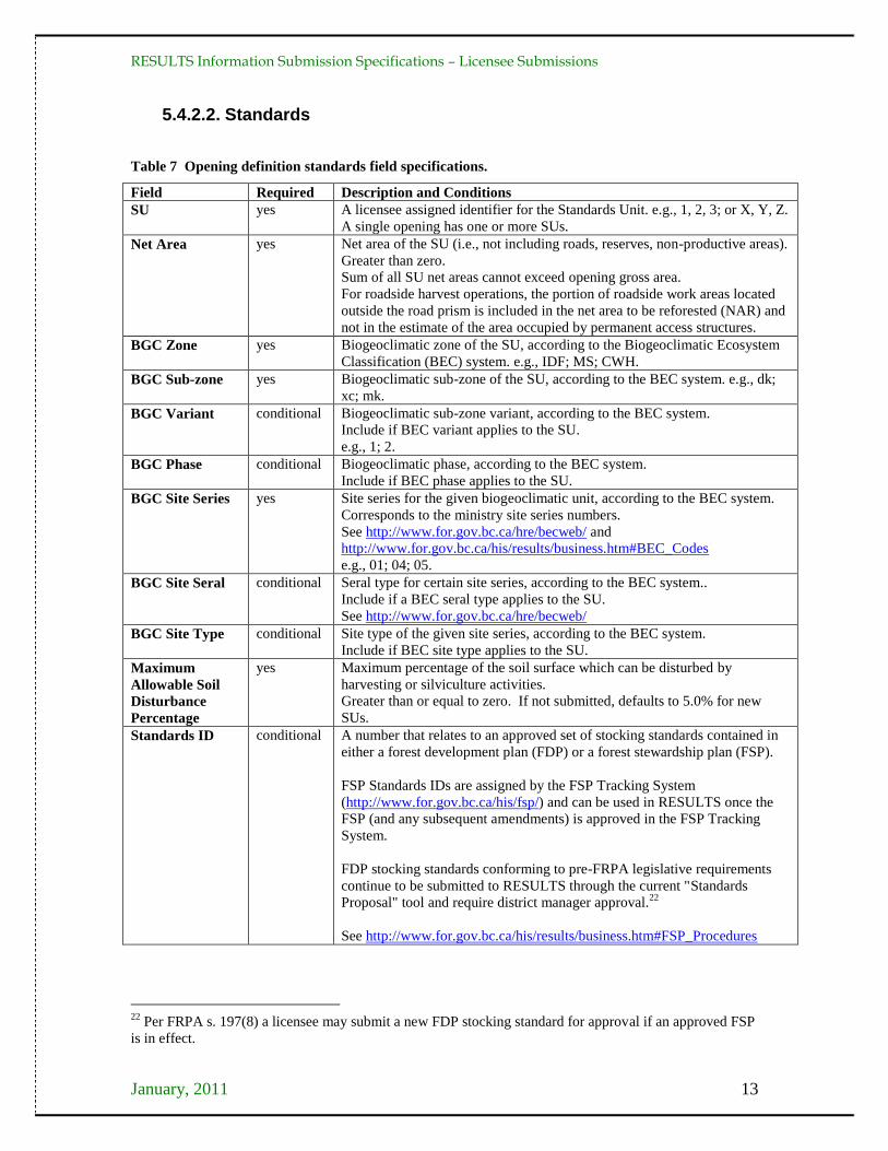
5.4.2.2. Standards
Table 7 Opening definition standards field specifications.
Field Required Description and Conditions
SU yes A licensee assigned identifier for the Standards Unit. e.g., 1, 2, 3; or X, Y, Z.
A single opening has one or more SUs.
Net Area yes Net area of the SU (i.e., not including roads, reserves, non-productive areas).
Greater than zero.
Sum of all SU net areas cannot exceed opening gross area.
For roadside harvest operations, the portion of roadside work areas located
outside the road prism is included in the net area to be reforested (NAR) and
not in the estimate of the area occupied by permanent access structures.
BGC Zone yes Biogeoclimatic zone of the SU, according to the Biogeoclimatic Ecosystem
Classification (BEC) system. e.g., IDF; MS; CWH.
BGC Sub-zone yes Biogeoclimatic sub-zone of the SU, according to the BEC system. e.g., dk;
xc; mk.
BGC Variant conditional Biogeoclimatic sub-zone variant, according to the BEC system.
Include if BEC variant applies to the SU.
e.g., 1; 2.
BGC Phase conditional Biogeoclimatic phase, according to the BEC system.
Include if BEC phase applies to the SU.
BGC Site Series yes Site series for the given biogeoclimatic unit, according to the BEC system.
Corresponds to the ministry site series numbers.
See http://www.for.gov.bc.ca/hre/becweb/ and
http://www.for.gov.bc.ca/his/results/business.htm#BEC_Codes
e.g., 01; 04; 05.
BGC Site Seral conditional Seral type for certain site series, according to the BEC system..
Include if a BEC seral type applies to the SU.
See http://www.for.gov.bc.ca/hre/becweb/
BGC Site Type conditional Site type of the given site series, according to the BEC system.
Include if BEC site type applies to the SU.
Maximum
Allowable Soil
Disturbance
Percentage
yes Maximum percentage of the soil surface which can be disturbed by
harvesting or silviculture activities.
Greater than or equal to zero. If not submitted, defaults to 5.0% for new
SUs.
Standards ID conditional A number that relates to an approved set of stocking standards contained in
either a forest development plan (FDP) or a forest stewardship plan (FSP).
FSP Standards IDs are assigned by the FSP Tracking System
(http://www.for.gov.bc.ca/his/fsp/) and can be used in RESULTS once the
FSP (and any subsequent amendments) is approved in the FSP Tracking
System.
FDP stocking standards conforming to pre-FRPA legislative requirements
continue to be submitted to RESULTS through the current "Standards
Proposal" tool and require district manager approval.22
See http://www.for.gov.bc.ca/his/results/business.htm#FSP_Procedures
22
Per FRPA s. 197(8) a licensee may submit a new FDP stocking standard for approval if an approved FSP
is in effect.
RESULTS Information Submission Specifications – Licensee Submissions
January, 2011 14
5.4.3. Attribute details
5.4.3.1. Tenure
The tenure information in FTA is added to the RESULTS opening definition
automatically. If an opening has multiple tenures (e.g., a timber licence [TL] within a tree
farm license [TFL], or private land within a TFL), each tenure is listed. One of the
tenures must be identified as the Prime Licence in RESULTS; and the other tenure(s)
must be identified as the secondary tenure(s) by setting the "Is Prime Licence" field to
"no" for those tenures.
5.4.3.2. Opening amalgamation
Openings can be amalgamated into a single opening to support FPPR s. 111
amalgamations.23
5.4.3.3. Standards ID
Only approved Standards IDs are available in RESULTS for assignment to SUs (e.g.,
provincial default standards, district-wide standards [if available], standards approved as
part an FDP specific to a licence holder, or FSP standards approved for a given licensee
through the FSP Tracking System).
Once a Standards ID is assigned to an opening in a RESULTS report, it is automatically
linked to the approved stocking standards, which can be viewed in RESULTS, the FSP
Tracking System, or through the CRS.
5.4.3.4. Previous stand label
The previous stand label fields include Previous:
Stand Type, Species 1, Species 2, Age Class, Height Class, Stock Class, Site
Index, and Site Index Source.
Report the previous forest cover inventory label information, unless better information is
available (e.g., pre-harvest survey or timber cruise) for the previous stand label fields.
No new survey information is required for these fields. If the opening has more than one
existing forest cover label, use the label from the largest polygon in the opening.
5.4.3.5. Site plan exempt cutblocks
If an area is exempt from requiring a site plan, an opening definition is submitted with the
site plan exempt indicator set to 'yes' if it meets the minimum polygon size specified in
Section 5.7.3.3.1.
5.4.3.6. Additional disturbances
Disturbances such as wildfires periodically impact existing openings. Licensees may
amend existing site plans or silviculture prescriptions, or create new site plans (to replace
the previous ones), to ensure that the Standards IDs/stocking standards for the SUs are
23
See RESULTS Information Submission Specifications – Government Funded Silviculture Activities at
http://www.for.gov.bc.ca/hfp/publications/00220/resultsSubmission.pdf

RESULTS Information Submission Specifications – Licensee Submissions
January, 2011 15
appropriate for managing the disturbed site. Updated disturbance, silviculture activity
and forest cover reports are submitted for the opening. Opening definitions may require
modifications to SUs and Standards IDs/stocking standards.
5.4.4. Spatial mapping data
Spatial information is required with opening definition reports.
The opening definition contains two spatial components: 1) the opening boundary; and,
2) the SU boundaries. An opening can have no more than one opening boundary, and can
have one or more SU boundaries according to the number of SUs within the opening.
The opening boundary defines the location of the opening inclusive of roads24
, reserves,
productive, and non-productive areas. The SU boundaries define each SU within the
opening.
The opening in Figure 2 consists of one SU and two wildlife tree patches (WTPs) that
have the same attribute information. The opening definition includes the entire opening
boundary, including the external WTP. The SU boundary excludes the WTPs.
Figure 2 Clearcut with two WTPs, one SU. II) Opening Gross Area comprises NAR, temporary access
road, and WTPs, and is a multi-part polygon. III) SU spatial data. Represents the NAR of the SU.
Excludes WTPs and is a polygon with an internal hole.
The opening in Figure 3 is comprised of harvested patches and mature timber, and can be
reported three ways, according to management objectives and how the opening
information is configured in FTA. The opening boundary can be: 1) an all-encompassing
polygon, with the SU comprised of all the harvested groups; 2) the same as the patches of
SU boundary; or, 3) a separate opening for each patch where the opening boundaries
correspond to the SU boundaries. The example in Figure 3 illustrates the first approach.
24
Authorised under a Cutting Permit or Timber Sale Licence. Roads under Road Permits are not included.

RESULTS Information Submission Specifications – Licensee Submissions
January, 2011 16
Figure 3 Group selection, with one SU. II) Opening boundary includes all the patches, residuals, and
temporary access structures in the opening. III) SU Spatial data. The patches and temporary access roads
are included in the SU boundary. A single multi-part polygon.
The opening in Figure 4 is a variable retention opening with three SUs defining distinct
stand structures, plus a reserve.
Figure 4 Variable retention opening with three SUs and a reserve. II) Gross Opening boundary
includes SUs and the reserve. III) Three SUs are delineated: 1-multi-part polygon that consists of a
clearcut (top) and two landings (bottom) that are managed according to the same stocking standards and
allowable soil disturbance %; 2-an area within which light single-tree selection harvest has occurred (not
discernible on the photo); 3-an area within which group selection harvest has occurred.
RESULTS Information Submission Specifications – Licensee Submissions
January, 2011 17
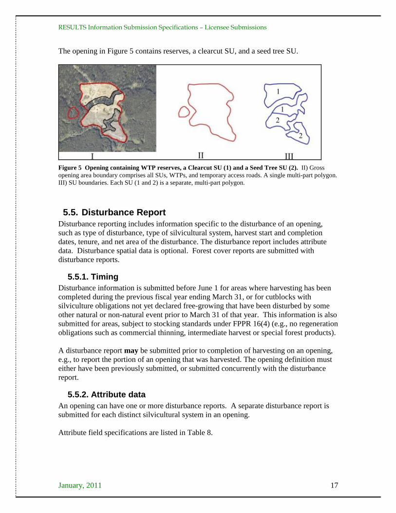
The opening in Figure 5 contains reserves, a clearcut SU, and a seed tree SU.
Figure 5 Opening containing WTP reserves, a Clearcut SU (1) and a Seed Tree SU (2). II) Gross
opening area boundary comprises all SUs, WTPs, and temporary access roads. A single multi-part polygon.
III) SU boundaries. Each SU (1 and 2) is a separate, multi-part polygon.
5.5. Disturbance Report
Disturbance reporting includes information specific to the disturbance of an opening,
such as type of disturbance, type of silvicultural system, harvest start and completion
dates, tenure, and net area of the disturbance. The disturbance report includes attribute
data. Disturbance spatial data is optional. Forest cover reports are submitted with
disturbance reports.
5.5.1. Timing
Disturbance information is submitted before June 1 for areas where harvesting has been
completed during the previous fiscal year ending March 31, or for cutblocks with
silviculture obligations not yet declared free-growing that have been disturbed by some
other natural or non-natural event prior to March 31 of that year. This information is also
submitted for areas, subject to stocking standards under FPPR 16(4) (e.g., no regeneration
obligations such as commercial thinning, intermediate harvest or special forest products).
A disturbance report may be submitted prior to completion of harvesting on an opening,
e.g., to report the portion of an opening that was harvested. The opening definition must
either have been previously submitted, or submitted concurrently with the disturbance
report.
5.5.2. Attribute data
An opening can have one or more disturbance reports. A separate disturbance report is
submitted for each distinct silvicultural system in an opening.
Attribute field specifications are listed in Table 8.
A
B

RESULTS Information Submission Specifications – Licensee Submissions
January, 2011 18
Table 8 Disturbance activities field specifications.
Field Required Description and Conditions
Action yes Values of either I (Insert) or U (Update). ‗I‘ is for new disturbance reports
to RESULTS, and ‗U‘ is to update disturbance reports previously
submitted to RESULTS.
ATU ID no An automatically generated sequential number to identify a specific
Activity. May be used to update information for a given disturbance.
Licensee ID optional Allows licensee to provide a unique identifier for the disturbance.
Licence
Number
yes Licence number of the opening corresponding to the cutting authority.
e.g., TFL49; A20019; W0012.
Cutting Permit conditional The cutting permit for the opening corresponding to the licence in the
cutting permit document, if one exists.
Cutblock yes The approved cutblock identifier for the opening.
No leading zeros. Special characters and spaces are not recommended
(e.g., -, /, _, *).
e.g., 1002LM.
Disturbance
Code
yes Code indicating the reason for the disturbance within the opening.
See Appendix A to locate Disturbance Code list)
e.g., B; F; L; S.
Disturbance
Start Date
yes Start date of the disturbance. Harvest commencement does not include
road building activity.
Not greater than today‘s date.
Disturbance
Completion
Date
yes Date when the disturbance is completed, after completion of primary
harvesting activities (falling and yarding). Other activities or further
requirements under the cutting authority are classified as post-harvest
activities. Used to determine milestone declaration dates.
Not greater than today‘s date.
Disturbance
Area
yes Area (ha's) of the opening that was disturbed by the present activity.
Includes: NAR, newly created roads, other unnatural non-productive
features (e.g., NP UNN – gravel pits, landings), and natural non-
productive sites (e.g., NP NAT, NCC – rocky outcrops, small swamps) too
small to map25
.
Does not include: retained (undisturbed) areas such as WTP or other
reserves of mature or immature timber, previously existing roads,
mappable natural non-productive areas (e.g., NP NAT – rock, swamps), or
mappable non-commercial cover (e.g., NCC – brush) identified on the site
plan that is excluded from the NAR.
Silvicultural
System
yes Code that identifies the primary category of silvicultural system used and
is either even-aged or uneven-aged.
Different silvicultural systems in an opening are reported separately.
See Appendix A to locate Silviculture System Code list.
Silvicultural
Variant
conditional Code that further describes the spatial layout of the silvicultural system.
Include if a variant applies to the silvicultural system.
See Appendix A to locate Silvicultural Variant Code list.
Silvicultural
Cut Phase
yes Code that describes the harvest entry or timing of the cut within the
prescription.
See Appendix A to locate Silvicultural Cut Phase Code list.
Is Harvest
Complete
yes A Yes/No indicator identifying if the primary harvest activities were
completed on the cutblock. This field sets the status of the cutblock in
FTA to ‗LC‘ (logging complete).
25
See sections 5.7.3.3 and 5.7.3.3.1.
RESULTS Information Submission Specifications – Licensee Submissions
January, 2011 19
5.5.3. Attribute details
5.5.3.1. Area-based licences
Holders of area-based licences that are subjects of pilot projects report area harvested by
calendar year, not at completion of harvest (FRPA s. 175). This allows cut control to be
assessed in accordance with provisions under the (Forest Act) Tree Farm Licence Area-
based Allowable Annual Cut Trial Program Regulation.
5.5.3.2. Multi-tenure openings
Disturbances on multi-tenure openings are reported separately for each tenure or block26
.
For example, if an opening located within a TFL includes a TL, two disturbance reports
are submitted: one disturbance report (attribute data) for the portion of the opening in the
TFL (excluding the TL area), and one disturbance report (attribute data) for the portion of
the opening in the TL.
5.5.3.3. FRPA s. 108
If an event causing damage (e.g., fire, landslide, or flood) that meets the requirements of
FRPA s 108 and FPPR s 96 has affected an area, FRPA s. 108 may provide funding or
relief of obligation. Before submitting a FRPA s. 108 application, submit a disturbance
report identifying the disturbance event (including spatial location). Include a description
of the event and the cutblock/opening showing the affected area, along with a forest
cover report.27
5.5.3.4. Other disturbances
Reporting disturbances, other than harvesting, maintains accuracy in provincial forest
cover databases and provincial timber supply analysis28
. Licensees report disturbances
that affect licensee operations (e.g., fires or other events that impact free-growing
obligations).
5.5.4. Spatial mapping data
Spatial disturbance area data is optional. Disturbance area consists of the NAR, newly
created roads, other unnatural non-productive features (e.g., NP UNN – gravel pits,
landings), and natural non-productive sites (e.g., NP NAT, NCC) too small to map29
.
Where multiple tenures govern a block, the reported disturbance area is apportioned by
tenure.
Figure 6 through Figure 9 show examples of different configurations of disturbed areas.
26
Other submissions (i.e., silviculture activity submissions) can be made under the primary licence or block
only. 27
See RESULTS Information Submission Specification – Government Funded Silviculture Activities at
http://www.for.gov.bc.ca/hfp/publications/00220/resultsSubmission.pdf. 28
Licensees are requested to notify the MFR of locations of disturbances that do not affect licensee
operations if they are discovered, so that MFR can arrange for surveys. 29
See sections 5.7.3.3 and 5.7.3.3.1.

RESULTS Information Submission Specifications – Licensee Submissions
January, 2011 20
Figure 6 Opening with reserves. II) Spatial data for the disturbed area of the opening. This is a polygon
with an internal hole.
Figure 7 Opening with patch cuts. II) Spatial data for the disturbed area of the opening. A multi-part
polygon.
Figure 8 Variable retention opening. II) Spatial data for the disturbed area of the opening. In this case,
only the reserve is excluded from the disturbed areas. The single tree and group tree selection areas are
considered part of the disturbed area because forest cover has been lightly altered.

RESULTS Information Submission Specifications – Licensee Submissions
January, 2011 21
Figure 9 Opening with reserves. II) Spatial data for the disturbed area of the opening
5.6. Silviculture Activity Report
The silviculture activity report includes information specific to silviculture treatments, as
defined by FPPR s.1, in an opening, including type of treatment, objectives, funding
source, and area treated. Attribute data are required, and spatial data are optional.
FRPA requires submission of annual silviculture treatment summary reports. Use one
(not both) of two possible reporting methods to meet this requirement:
1. Reports by Opening. The silviculture activity reports are submitted for each
opening through ESF. Data is submitted by Opening under any of the following
circumstances30
:
government-funded projects;
openings on which planting activities have been completed; or,
openings with outstanding FPC obligations.
2. Summary Reports by Tenure. The summary data for the tenure is entered into the
RESULTS341 – Annual Silviculture Accomplishments screen, accessed by the
Data Submission drop-down menu in RESULTS (online only). Required fields are
District, Licence, Fiscal Year Ending, Base, Technique, Method, Funding Source, and
Area (ha). Licensees who report silviculture treatments by individual openings for all
treated openings are not required to submit annual silviculture summaries through
the RESULTS341 – Annual Silviculture Accomplishments screen.
5.6.1. Timing
Silviculture treatment information is submitted before June 1 for areas treated before
April 1 of that year.
30
The Annual Silviculture Accomplishments reporting option is not applicable for these cases.

RESULTS Information Submission Specifications – Licensee Submissions
January, 2011 22
5.6.2. Attribute data
Attribute field specifications for silviculture activities reported by opening are listed in
Table 9. An opening can have one or more silviculture activity reports. Table 10 shows
attribute field specifications for silviculture summaries reported by tenure.
Table 9 Silviculture activities field specifications when reported by opening
Field Required Description and Conditions
Action yes Values of either I (Insert) or U (Update). ‗I‘ is for new reports to
RESULTS, and ‗U‘ is to update silviculture activity reports previously
submitted to RESULTS.
ATU ID no An automatically generated sequential number to identify a specific
Activity. May be used to update subsequent information (online) for a
given treatment.
Activity Base yes Code that identifies a primary category of silviculture treatment or activity.
See Appendix A to locate Activity Base Code list.
Technique conditional Code that identifies a general technique for accomplishing silviculture
activity and may be a descriptor of the base activity. Depends on Activity
Base.
See Appendix A to locate Activity Technique Code list.
Method conditional Code that identifies a specific method for accomplishing silviculture work
and is a subdivision of technique. Methods describe a physical process for
accomplishing work. Depends on Activity Base/Technique.
See Appendix A to locate Activity Method Code list.
Activity Cost
optional Projected cost of the planned activity if the Actual Date Indicator is set to
"no". Actual cost of the completed activity if the Actual Date Indicator is
set to "yes". (Required for government-funded activities.)
Objective 1 optional Code that describes the reason for the silviculture treatment. Depends on
Base Activity. Three objectives per activity are allowed.
See Appendix A to locate Objective Code list.
Objective 2 optional Code that describes the reason for the silviculture treatment. Depends on
Base Activity. Three objectives per activity are allowed.
See Appendix A to locate Objective Code list.
Objective 3 optional Code that describes the reason for the silviculture treatment. Depends on
Base Activity. Three objectives per activity are allowed.
See Appendix A to locate Objective Code list.
Actual Date
Indicator
yes A "yes" or "no" indicator. Set to "yes" if the activity has been completed31
.
Activity Date yes Date of the completed activity. If the Actual Date Indicator is set to "yes",
this is the date on which the activity was completed.32
Required if the
activity is complete.
Licensee ID optional Licensee Activity ID. A unique identifier provided by the Licensee to
identify the activity.
Used to submit an update to an existing activity. RESULTS uses the
Licensee ID to identify the treatment record to be updated. To update an
activity without a Licensee ID, ATU ID (available online) for the activity
can be input in the Licensee ID field.
31
A setting of "no" indicates a planned activity ("no" setting is optional for licensee obligations). 32
If the Actual Date Indicator is set to "no" this is the planned commencement date for the activity.
Planned date is used to schedule activities for ministry-managed Non-replaceable Forest Licenses (NRFLs),
and Forest Investment Account (FIA) activities.
RESULTS Information Submission Specifications – Licensee Submissions
January, 2011 23
Field Required Description and Conditions
Funding Source yes Code that identifies the funding source for silviculture treatment.
See Appendix A to locate Funding Source Code list.
e.g., IA – industry appraisal; FTL – Forests for Tomorrow licensee
administrated; FIL – FIA Licensee.
Funding Project
Number
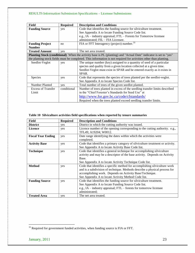
no FIA or FFT Interagency (project) number.33
Treated Amount yes The net area treated.
Planting Stock (conditional) When the activity base is PL (planting) and "Actual Date" indicator is set to "yes"
the planting stock fields must be completed. This information is not required for activities other than planting.
Seedlot-Veglot yes The unique number (key) assigned to a quantity of seed of a particular
species and quality from a given location collected at a given time.
Seedlot-Veglot must exist in SPAR and be entered exactly as it exists in
SPAR.
Species yes Code that represents the species of trees planted per the seedlot-veglot.
See Appendix A to locate Species Code list.
Number Planted yes Total number of trees of the given seedlot planted.
Excess of Transfer
Limit
conditional Number of trees planted in excess of the seedling transfer limits described
in the ―Chief Forester‘s Standards for Seed Use‖ at
http://www.for.gov.bc.ca/code/cfstandards/ Required when the trees planted exceed seedling transfer limits.
Table 10 Silviculture activities field specifications when reported by tenure summaries
Field Required Description and Conditions
District yes District in which the cutting authority was issued.
Licence yes Licence number of the opening corresponding to the cutting authority. e.g.,
TFL49; A19204; W0012.
Fiscal Year Ending yes Date range identifying the dates within which the activities were
completed.
Activity Base yes Code that identifies a primary category of silviculture treatment or activity.
See Appendix A to locate Activity Base Code list.
Technique yes Code that identifies a general technique for accomplishing silviculture
activity and may be a descriptor of the base activity. Depends on Activity
Base.
See Appendix A to locate Activity Technique Code list.
Method yes Code that identifies a specific method for accomplishing silviculture work
and is a subdivision of technique. Methods describe a physical process for
accomplishing work. Depends on Activity Base/Technique.
See Appendix A to locate Activity Method Code list.
Funding Source yes Code that identifies the funding source for silviculture treatment.
See Appendix A to locate Funding Source Code list.
e.g., IA – industry appraisal; FTL – forests for tomorrow licensee
administrated;
Treated Area yes The net area treated.
33
Required for government funded activities, when funding source is FIA or FFT.
RESULTS Information Submission Specifications – Licensee Submissions
January, 2011 24
5.6.3. Attribute details
5.6.3.1. Activity treatment units
Treatments are reported by silviculture activity treatment units (ATUs). An opening can
contain several silviculture ATUs, which can overlap. Each unit is reported as a separate
silviculture activity within an opening.
5.6.3.2. Harvest and planting in the same reporting period
When harvesting completion and planting occur within the same reporting period, a
disturbance report and a silviculture activity report are submitted. A forest cover report is
submitted with the disturbance report. If the SU is satisfactorily restocked as a result of
the planting activity, an additional forest cover report is submitted. If the SU remains
NSR, no additional forest cover report is submitted.
5.6.3.3. Additional disturbances
See Section 5.4.3.6
5.6.3.4. Silviculture surveys
Submission of data pertaining to planning or completion of silviculture surveys is
optional for licensees.
5.6.4. Spatial mapping data
Spatial data are optional for silviculture activity treatment unit reports for licensees.
5.7. Forest Cover Inventory Report
Forest cover inventory reports include forest cover inventory attribute data (e.g., area,
number of trees, tree species, tree species percent, damage agents, non-mapped
components, etc.) and spatial data (e.g., spatial location, shape of the polygon, etc.) for
each polygon in an opening. They are also referred to as "forest cover polygon reports".
Forest cover attribute and spatial data are submitted through the ESF, and can be viewed
and corrected (attribute data only) in RESULTS.
All polygons within the opening are reported (listed with attributes and located on the
map). Polygons within the opening that were not surveyed (or treated) are identified and
their locations and attributes are included as part of the report, along with the reference
year (the year to which the attribute information applies; generally the last time the
polygon was treated or surveyed). Hence, each report for an opening includes: 1) all
polygons within all Standards Units (as defined by FPPR s. 1(1)) for an opening; and, 2)
all polygons within the opening that are excluded from Standards Units (i.e., excluded
from the NAR per FPPR s. 1(2)).
The minister's information requirements for forest cover inventory as defined by FPPR
s.1 are outlined in Section 5.7 and its subsections, and are summarised in Table 11
through Table 14 (inclusive).

RESULTS Information Submission Specifications – Licensee Submissions
January, 2011 25
5.7.1. Timing
Forest cover polygon information is submitted before June 1 for each area:
1. where harvesting has been completed prior to March 31 of that year;
2. that has met regeneration date requirements up to March 31 of that year;
3. that has not met regeneration requirements but the regeneration date has passed prior
to March 31 of that year;
4. that has met free-growing date requirements up to March 31 of that year for reports
submitted to fulfill outstanding THSPR obligations;
5. where a free growing declaration has been made in accordance with FRPA 107 and
FPPR 97; or,
6. that has not met free-growing date requirements but the late free-growing date has
passed prior to March 31 of that year.
Forest cover information submitted as part of a declaration for areas subject to
requirements under FPPR 44 (4) is submitted no sooner than 12 months following the
completion of harvesting.
No additional forest cover report is required if a forest cover report has been submitted
together with a milestone declaration during the reporting period.
5.7.2. Attribute data
An opening can have one or more forest cover polygon reports. Each forest cover
polygon report can have a non-mapped component, and one or more layers. Each layer
can have one or more tree species, and one or more damage agents.
Four components comprise the forest cover inventory data in RESULTS: polygon,
inventory, silviculture, and non-mapped. The polygon component is submitted for all
polygon reports. The inventory and silviculture components are submitted for polygons
within SUs. Only the inventory component is submitted in the case of reserves or
polygons outside of SUs. The non-mapped component accounts for areas too small to
map that are removed from the NAR within a given polygon. Field specifications for
forest cover attributes are in Table 11 through Table 14.

RESULTS Information Submission Specifications – Licensee Submissions
January, 2011 26
5.7.2.1. Polygon component
Table 11 Forest cover "polygon component" field specifications.
Field Required Description and Conditions
Standards Unit ID conditional The SU associated with the forest cover polygon.
Required if the polygon (including a reserve) is within a "Standards
Unit" as defined by FPPR 1(1) and subject to "net area to be
reforested" as defined by FPPR 1(2).
Licensee ID yes Unique identifier for the forest cover polygon assigned by the licensee.
In RESULTS this field is referred to as Polygon ID.
No duplicates permitted.
e.g., 1, 2, 3; or X, Y, Z.
Area yes Gross area (ha) of the forest cover polygon. (Net area is derived by
subtracting any non-mapped area.)
Reference Year yes Year the forest cover polygon data were collected.
Typically the year of the survey.
Less than or equal to the declared date when submitting with a
declaration.
For roads and other NP areas, the reference year may be different from
the survey date, and reflects the date the road was measured or the
block area was determined.
Re-entry Year conditional Year the next harvest entry is expected to occur in the opening.
Applies to partial-cut silvicultural systems in which a subsequent
harvest entry is planned prior to the end of the rotational planning
cycle. Required where Reserve Objective = TIM.
Stocking Status yes Code representing the growing space occupancy relative to a pre-
established standard. Status refers to whether the site has achieved
those standards, according to the latest silviculture survey. Stocking
status is most often described as not satisfactorily restocked (NSR),
immature (IMM) or mature (MAT).
In a multi-storied stand, select the code which describes the stocking
status of the next layer to be harvested, the layer with the highest site
occupancy.
See Appendix A to locate Stocking Status Code list.
Stocking Type yes Code representing a sub-classification of the stocking status.
In a multi-storied stand, select the code which describes the stocking
type of the next layer to be harvested, the layer with the highest site
occupancy.
See Appendix A to locate Stocking Type Code list)
e.g., natural (NAT); plantable (PL); non-plantable (NPL).
Reserve Type conditional Code that identifies the spatial pattern of a reserve or retention area
associated with a silvicultural system. Required if a reserve or a
retention area is associated with the forest cover polygon.
"G-Group" (a defined, mapped patch of residual trees) or
"D-Dispersed" (a defined area within which are dispersed unmapped
residual single trees or small clusters of trees).
Reserve Objective conditional Code that identifies the reason for leaving the reserve.
Required if Reserve Type = G or D.
See Appendix A to locate Silviculture Reserve Objective Code list.
Code for long term (full rotational planning cycle) reserve is any code
other than "TIM".
Code for retention area associated with a silvicultural system, in which
the residual stems are available for a subsequent harvest prior to the
end of the rotational planning cycle (e.g., second pass), is "TIM".
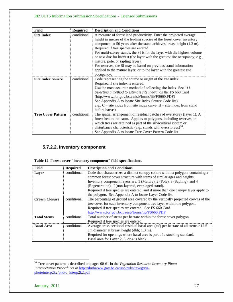
RESULTS Information Submission Specifications – Licensee Submissions
January, 2011 27
Field Required Description and Conditions
Site Index conditional A measure of forest land productivity. Enter the projected average
height in metres of the leading species of the forest cover inventory
component at 50 years after the stand achieves breast height (1.3 m).
Required if tree species are entered.
For multi-storey stands, the SI is for the layer with the highest volume
or next due for harvest (the layer with the greatest site occupancy; e.g.,
mature, pole, or sapling layer).
For reserves, the SI may be based on previous stand information
applied to the mature layer, or to the layer with the greatest site
occupancy.
Site Index Source conditional Code representing the source or origin of the site index.
Required if site index is entered.
Use the most accurate method of collecting site index. See ―11.
Selecting a method to estimate site index‖ on the FS 660 Card
(http://www.for.gov.bc.ca/isb/forms/lib/FS660.PDF)
See Appendix A to locate Site Index Source Code list)
e.g., C – site index from site index curve; H – site index from stand
before harvest.
Tree Cover Pattern conditional The spatial arrangement of residual patches of overstorey (layer 1). A
forest health indicator. Applies to polygons, including reserves, in
which trees are retained as part of the silvicultural system or
disturbance characteristic (e.g., stands with overstoreys)34
.
See Appendix A to locate Tree Cover Pattern Code list
5.7.2.2. Inventory component
Table 12 Forest cover "inventory component" field specifications.
Field Required Description and Conditions
Layer conditional Code that characterizes a distinct canopy cohort within a polygon, containing a
common forest cover structure with stems of similar ages and heights.
Inventory component layers are: 1 (Mature), 2 (Pole), 3 (Sapling), and 4
(Regeneration). I (non-layered, even-aged stand).
Required if tree species are entered, and if more than one canopy layer apply to
the polygon. See Appendix A to locate Layer Code list.
Crown Closure conditional The percentage of ground area covered by the vertically projected crowns of the
tree cover for each inventory component tree layer within the polygon.
Required if tree species are entered. See FS 660 Card.
http://www.for.gov.bc.ca/isb/forms/lib/FS660.PDF
Total Stems conditional Total number of stems per hectare within the forest cover polygon.
Required if tree species are entered.
Basal Area conditional Average cross-sectional residual basal area (m2) per hectare of all stems >12.5
cm diameter at breast height (dbh; 1.3 m).
Required for openings where basal area is part of a stocking standard.
Basal area for Layer 2, 3, or 4 is blank.
34
Tree cover pattern is described on pages 60-61 in the Vegetation Resource Inventory Photo
Interpretation Procedures at http://ilmbwww.gov.bc.ca/risc/pubs/teveg/vri-
photointerp2k2/photo_interp2k2.pdf
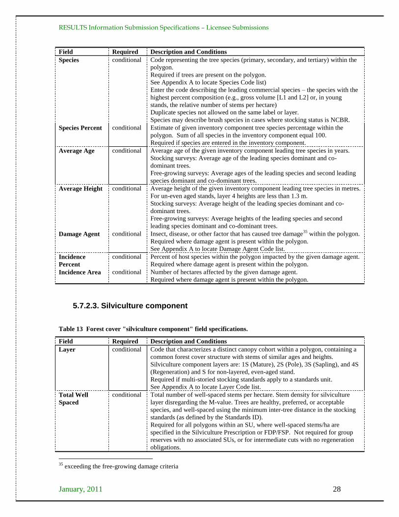
RESULTS Information Submission Specifications – Licensee Submissions
January, 2011 28
Field Required Description and Conditions
Species conditional Code representing the tree species (primary, secondary, and tertiary) within the
polygon.
Required if trees are present on the polygon.
See Appendix A to locate Species Code list)
Enter the code describing the leading commercial species – the species with the
highest percent composition (e.g., gross volume [L1 and L2] or, in young
stands, the relative number of stems per hectare)
Duplicate species not allowed on the same label or layer.
Species may describe brush species in cases where stocking status is NCBR.
Species Percent conditional Estimate of given inventory component tree species percentage within the
polygon. Sum of all species in the inventory component equal 100.
Required if species are entered in the inventory component.
Average Age conditional Average age of the given inventory component leading tree species in years.
Stocking surveys: Average age of the leading species dominant and co-
dominant trees.
Free-growing surveys: Average ages of the leading species and second leading
species dominant and co-dominant trees.
Average Height conditional Average height of the given inventory component leading tree species in metres.
For un-even aged stands, layer 4 heights are less than 1.3 m.
Stocking surveys: Average height of the leading species dominant and co-
dominant trees.
Free-growing surveys: Average heights of the leading species and second
leading species dominant and co-dominant trees.
Damage Agent conditional Insect, disease, or other factor that has caused tree damage35
within the polygon.
Required where damage agent is present within the polygon.
See Appendix A to locate Damage Agent Code list.
Incidence
Percent
conditional Percent of host species within the polygon impacted by the given damage agent.
Required where damage agent is present within the polygon.
Incidence Area conditional Number of hectares affected by the given damage agent.
Required where damage agent is present within the polygon.
5.7.2.3. Silviculture component
Table 13 Forest cover "silviculture component" field specifications.
Field Required Description and Conditions
Layer conditional Code that characterizes a distinct canopy cohort within a polygon, containing a
common forest cover structure with stems of similar ages and heights.
Silviculture component layers are: 1S (Mature), 2S (Pole), 3S (Sapling), and 4S
(Regeneration) and S for non-layered, even-aged stand.
Required if multi-storied stocking standards apply to a standards unit.
See Appendix A to locate Layer Code list.
Total Well
Spaced
conditional Total number of well-spaced stems per hectare. Stem density for silviculture
layer disregarding the M-value. Trees are healthy, preferred, or acceptable
species, and well-spaced using the minimum inter-tree distance in the stocking
standards (as defined by the Standards ID).
Required for all polygons within an SU, where well-spaced stems/ha are
specified in the Silviculture Prescription or FDP/FSP. Not required for group
reserves with no associated SUs, or for intermediate cuts with no regeneration
obligations.
35
exceeding the free-growing damage criteria
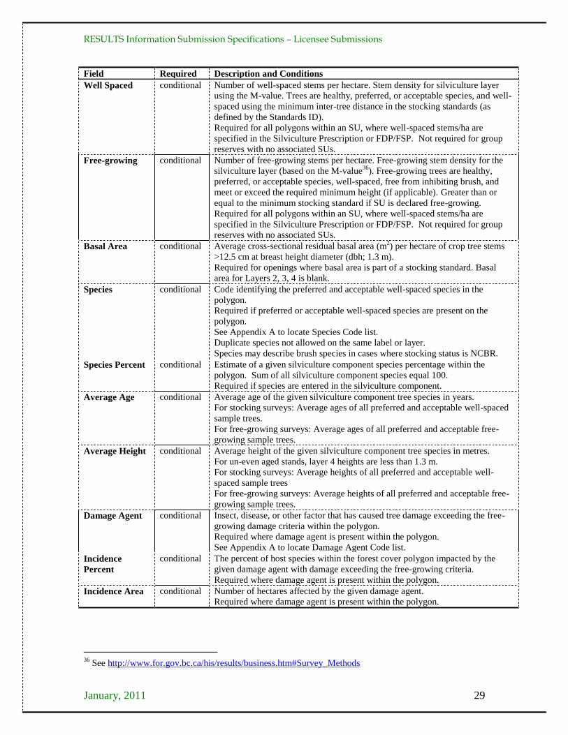
RESULTS Information Submission Specifications – Licensee Submissions
January, 2011 29
Field Required Description and Conditions
Well Spaced conditional Number of well-spaced stems per hectare. Stem density for silviculture layer
using the M-value. Trees are healthy, preferred, or acceptable species, and well-
spaced using the minimum inter-tree distance in the stocking standards (as
defined by the Standards ID).
Required for all polygons within an SU, where well-spaced stems/ha are
specified in the Silviculture Prescription or FDP/FSP. Not required for group
reserves with no associated SUs.
Free-growing conditional Number of free-growing stems per hectare. Free-growing stem density for the
silviculture layer (based on the M-value36
). Free-growing trees are healthy,
preferred, or acceptable species, well-spaced, free from inhibiting brush, and
meet or exceed the required minimum height (if applicable). Greater than or
equal to the minimum stocking standard if SU is declared free-growing.
Required for all polygons within an SU, where well-spaced stems/ha are
specified in the Silviculture Prescription or FDP/FSP. Not required for group
reserves with no associated SUs.
Basal Area conditional Average cross-sectional residual basal area (m2) per hectare of crop tree stems
>12.5 cm at breast height diameter (dbh; 1.3 m).
Required for openings where basal area is part of a stocking standard. Basal
area for Layers 2, 3, 4 is blank.
Species conditional Code identifying the preferred and acceptable well-spaced species in the
polygon.
Required if preferred or acceptable well-spaced species are present on the
polygon.
See Appendix A to locate Species Code list.
Duplicate species not allowed on the same label or layer.
Species may describe brush species in cases where stocking status is NCBR.
Species Percent conditional Estimate of a given silviculture component species percentage within the
polygon. Sum of all silviculture component species equal 100.
Required if species are entered in the silviculture component.
Average Age conditional Average age of the given silviculture component tree species in years.
For stocking surveys: Average ages of all preferred and acceptable well-spaced
sample trees.
For free-growing surveys: Average ages of all preferred and acceptable free-
growing sample trees.
Average Height conditional Average height of the given silviculture component tree species in metres.
For un-even aged stands, layer 4 heights are less than 1.3 m.
For stocking surveys: Average heights of all preferred and acceptable well-
spaced sample trees
For free-growing surveys: Average heights of all preferred and acceptable free-
growing sample trees.
Damage Agent conditional Insect, disease, or other factor that has caused tree damage exceeding the free-
growing damage criteria within the polygon.
Required where damage agent is present within the polygon.
See Appendix A to locate Damage Agent Code list.
Incidence
Percent
conditional The percent of host species within the forest cover polygon impacted by the
given damage agent with damage exceeding the free-growing criteria.
Required where damage agent is present within the polygon.
Incidence Area conditional Number of hectares affected by the given damage agent.
Required where damage agent is present within the polygon.
36
See http://www.for.gov.bc.ca/his/results/business.htm#Survey_Methods
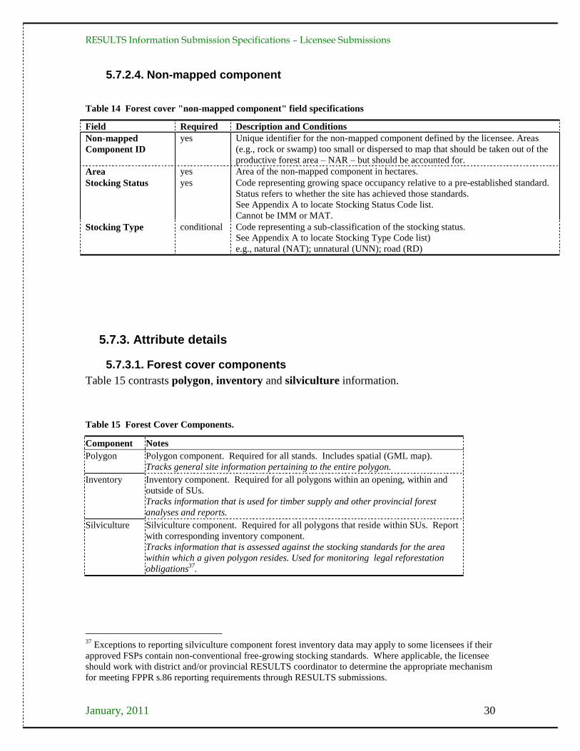
RESULTS Information Submission Specifications – Licensee Submissions
January, 2011 30
5.7.2.4. Non-mapped component
Table 14 Forest cover "non-mapped component" field specifications
Field Required Description and Conditions
Non-mapped
Component ID
yes Unique identifier for the non-mapped component defined by the licensee. Areas
(e.g., rock or swamp) too small or dispersed to map that should be taken out of the
productive forest area – NAR – but should be accounted for.
Area yes Area of the non-mapped component in hectares.
Stocking Status yes Code representing growing space occupancy relative to a pre-established standard.
Status refers to whether the site has achieved those standards.
See Appendix A to locate Stocking Status Code list.
Cannot be IMM or MAT.
Stocking Type conditional Code representing a sub-classification of the stocking status.
See Appendix A to locate Stocking Type Code list)
e.g., natural (NAT); unnatural (UNN); road (RD)
5.7.3. Attribute details
5.7.3.1. Forest cover components
Table 15 contrasts polygon, inventory and silviculture information.
Table 15 Forest Cover Components.
Component Notes
Polygon Polygon component. Required for all stands. Includes spatial (GML map).
Tracks general site information pertaining to the entire polygon.
Inventory Inventory component. Required for all polygons within an opening, within and
outside of SUs.
Tracks information that is used for timber supply and other provincial forest
analyses and reports.
Silviculture Silviculture component. Required for all polygons that reside within SUs. Report
with corresponding inventory component.
Tracks information that is assessed against the stocking standards for the area
within which a given polygon resides. Used for monitoring legal reforestation
obligations37
.
37
Exceptions to reporting silviculture component forest inventory data may apply to some licensees if their
approved FSPs contain non-conventional free-growing stocking standards. Where applicable, the licensee
should work with district and/or provincial RESULTS coordinator to determine the appropriate mechanism
for meeting FPPR s.86 reporting requirements through RESULTS submissions.
RESULTS Information Submission Specifications – Licensee Submissions
January, 2011 31
5.7.3.2. Additional disturbances
See Section 5.4.3.6
5.7.3.3. Stratification
New polygons are created in the following cases (not a complete list)38
:
More than a 20% difference in leading species composition (e.g., Pl8Sx2 is
separated from Pl5Sx5);
Change in the leading species (e.g., Fdc8Cw2 is separated from Cw6Fdc4);
Species composition changes from a mixed species to a pure stand (e.g., Fdc10 is
separated from Fdc7Hw2Cw1);
Any stratum that does not meet the required minimum stocking standard at the
regeneration or free-growing time frames within the confines of FPPR s. 46.11;
Any stratum that has more than the allowable number of countable stems/ha
specified in a plan, prescription, or ministry policy;
Any stratum with residual basal area retained (e.g., clear cut portion is separated
from portion with residual basal area retained)
Age difference between the leading inventory species in adjacent strata is 20 years
or more;
Height difference between the leading inventory species in adjacent strata is 10 m
or more;
Site index based on the leading inventory species in adjacent strata differs by
more than 3 m; and,
Different NP types (e.g., NP BR versus NP UNN).
If a forest cover type crosses an SU boundary, the forest cover polygon is divided into
two polygons. Where an opening is not stratified into units smaller than SUs, the forest
cover polygons are the same as the SUs that are identified for the opening.
5.7.3.3.1. Minimum polygon size
Recommended minimum polygon sizes for RESULTS spatial submissions depend on:
1) whether or not the polygon is associated with an SU, 2) the area of the SU (if
applicable), 3) a polygon's stocking status, and, 4) whether or not the report relates to a
milestone declaration.
Recommended minimum polygon sizes are, for:
SUs less than 1 ha, the entire SU39
for declaring milestones.
SUs that exceed 1 ha, for declaring:
Post-harvest or regeneration milestones of an SU that is stocked or NSR: 1 hectare
Free-growing date milestones of a free-growing SU: 1-2 hectare40
38
See also Survey Methods and Stratification at
http://www.for.gov.bc.ca/his/results/business.htm#Survey_Methods 39
RESULTS can accommodate polygons to 0.1 ha. 40
At the time of free growing a minimum of 1 hectare and a maximum of 2 hectare of mappable non free
growing area may exist and the obligation is still considered achieved as long as the non free growing area
does not exceed 5 % of the SU area. (See FPPR section 46.11)
RESULTS Information Submission Specifications – Licensee Submissions
January, 2011 32
Free-growing date milestones of an SU that is not free-growing: 1 to 2 hectares,
provided the polygon is less than 5% of the SU NAR and is mappable41
.
Classifying Reserves and NP areas42
: 0.25 hectares (for mappable polygons)
Polygons that are stocked or free-growing, and are not submitted as part of a free-
growing declaration, where boundaries are:
recognizable and distinct on an air photo, differences in stand type are classified
to a minimum polygon size of 2 hectares43
; or,
not recognizable and distinct on an air photo, differences in stand type are
classified to a minimum polygon size of 5 hectares.
5.7.3.4. Multi-layer stands
If the stand is even-aged and single-layered, then only one layer of forest cover
information is reported in the silviculture and inventory components. If the stand is
multi-layered, then up to four layers of forest cover information are reported for the
silviculture and inventory components.
5.7.3.4.1. Residuals
For multi-layer stands, or stands with long term reserves or short-term retention, the area
from which timber is removed is referred to as "denuded" (or "harvested") portion of the
stand. Any remaining retained trees are referred to as "residuals". The forest cover
attributes for both the denuded portion and residual portion of the stand are reported
using the forest cover multi-layer fields.
5.7.3.4.2. Uniform partial cuts with no regeneration objectives
For areas where:
uniform removal of standing timber occurs within an SU;
the species profile retained is the same as the previous stand (i.e., no change in
leading species or removal of a subordinate species); and,
the volume or basal area removed or retained across the stand profile is consistent with that specified as part of the approved standard,
forest cover information is submitted to report the polygon attributes and their locations
within the cutblock after harvest. In this case, the map and attribute data may be based on
pre-existing cruise or forest cover attribute information describing the polygon44
.
41
Suggested definition of "mappable": a polygon greater than 20 meters throughout its length. Areas that
do not meet stocking obligations less than 20 m from the nearest NSR or not free-growing area are
considered contiguous units. 42
RESULTS can accommodate smaller polygons (e.g., 0.1 ha), to allow for clarity in reporting diverse
forest management regimes (e.g., wildlife tree patches, research trials). 43
Subject to minimum size constraints in Section 5.7.3.3.1. 44
No new survey is required.
RESULTS Information Submission Specifications – Licensee Submissions
January, 2011 33
5.7.3.5. Reserves, roads, and other mapped features
Distinct forest cover polygons are created for reserves, roads45
, and other mapped
features within an opening. These polygons are associated with an Opening ID, and they
must align with the Opening Definition boundaries.
5.7.3.5.1. Reserves fields
Reserves are forested patches or individual trees retained during harvesting, or other
forestry operations, to provide habitat, scenic, biodiversity, and other values. These areas
or trees are usually retained for one or more rotations. The RESULTS "Reserve Type"
and "Reserve Objective" fields are used to classify residuals in both long term reserves
and residuals left for less than a rotation as part of a silvicultural system.
Reserve Type refers to the spatial pattern of the residuals: "Group" or "Dispersed".
"Group": a defined, mapped patch of trees, generally does not have NAR46
.
"Dispersed": trees that are retained individually or in unmapped groups (e.g., small
clusters <0.25 ha), but are enclosed within the boundaries of the mapped polygon
designated as "dispersed reserve"; has NAR.
Reserve Objective refers to the management goal of the retained trees. Residuals left as
part of a silvicultural system are distinguished from residuals left as part of a reserve.
Reserves that are constrained for an entire rotation are assigned reserve objective codes
according to the primary constraining objective, e.g., Wildlife tree retention (WTR),
Riparian reserve (RMA), or any objective other than timber management "TIM".
Retained trees not associated with a long-term constraint are assigned the objective of
TIM and are modeled as contributing to future timber supply whether or not a second
harvest entry is scheduled or planned.
Reserves within which harvesting has occurred (e.g., dispersed reserves) are associated
with an SU47
. In this case, polygon, inventory, and silviculture component information is
required.
Group reserves do not have harvest entries or associated silviculture responsibilities and
are mapped and reported. Silviculture component information is not required in this case.
Only polygon and inventory components are submitted.
E.g., If a polygon is assigned a reserve objective "TIM", then the forest cover pertaining
to a "mature" layer or "pole" layer within that polygon is considered to be part of a
silvicultural system that features some kind of retention of residuals (e.g., residuals for a
seed tree silvicultural system, single or group selection, retention system, shelterwood,
patch cut, etc...). These residuals are considered to be available for harvesting during a
future cutting cycle prior to the end of the rotation; whereas, residuals left as part of a
45
Roads or temporary access structures that are within the maximum soil disturbance percentage limits
may be reported as non-mappable portion of the SU if they do not meet the minimum polygon size and
stratification criteria in Sections 5.7.3.3.1 and 5.7.3.3. 46
unless, under special cases, it is subject to harvest activities as in a Reserve with Modifications 47
This serves as the linkage to the stocking standard.

RESULTS Information Submission Specifications – Licensee Submissions
January, 2011 34
reserve are considered to be not available for harvest until the end of the rotation. Figure
10 summarises how reserves are classified in RESULTS.
Figure 10 Reserve and retention classification key.
5.7.3.5.2. Tracking reserves
Reserves are tracked as polygons, with data summarised in Appendix C. Tracking
Reserves.
Group reserves are often reported as even-aged. Residual stems comprise the entire
reserve. Report the layer with the most significant site occupancy (often the "mature"
layer).
Dispersed reserves are reported as multi-layer stands where the level of dispersed retention is > 548 m2 per hectare of residual basal area and are associated with an SU. At a minimum 2 layers are reported: the denuded layer, and the layer containing the residual stems.
Report the best information available for the residual stems. If recent survey
(including ocular estimates) or timber cruise information is not available (it is not a
requirement to survey the residual component of reserves), report forest cover
information from the existing inventory label49
, citing the appropriate reference year.
5.7.3.5.3. Mapping reserves:
48
Where dispersed retention levels are < 5 m2 per hectare the layer containing the residual stems does not
need to be reported although it is considered a best management practice to do so if the retention is linked
to an FSP result or strategy or associated with a silvicultural system (e.g., seed tree). 49
To the extent that the information exists in the previous forest cover label

RESULTS Information Submission Specifications – Licensee Submissions
January, 2011 35
Group Reserves 0.25 ha or greater: Group reserves equal to or greater than 0.25 ha are
mapped, including fully external reserves.
Dispersed Reserves: Dispersed reserves are mapped as part of a standards unit. Any
density50
of dispersed retention is included within a standards unit.
Reserves less than 0.25 ha: Reserves from 0.1 to 0.24 ha, are tracked. If the exact
locations of these reserves are mapped they may be reported as individual "Group"
reserves. If the exact locations of these reserves are not mapped, they are reported as
"Dispersed" reserves within an SU, and the polygons within which they are located are
mapped, although the individual trees themselves are not mapped.
5.7.3.6. Non-productive areas
Forest cover reports for non-productive areas, including roads, include Polygon ID (or
Non Mapped Component ID if the NP area is not mappable), area, stocking status,
stocking type, and reference year (see Section 5.7.3.6.1). If species is recorded, age and
height are also recorded (inventory component only). Remaining forest cover data is
optional. Once reported at harvest, the reference year is the same at regeneration delay,
and free-growing if stocking status has not changed. Non-productive areas, including
roads or temporary access structures, that meet the minimum polygon size are mapped.
5.7.3.6.1. Roads
Roads are reported according to how they are tenured, whether they are permanent or
temporary, and how they align with the SU.
Permanent access roads under a Road Permit are not reported. Permanent access roads
under a Cutting Permit or Licence to Cut are reported as part of the non-productive gross
opening area and as individual forest cover polygons (NP-RD).
Temporary access roads (and other temporary structures such as landings) associated
with a Cutting Permit or Licence to Cut are reported, generally as NP-UNN. How they
are reported depends on the FSP stocking standards requirements and the size of the
polygon. A temporary road or landing is mapped as a distinct polygon within an SU, or it
can be reported as a non-mapped component if it is less than the minimum polygon size
criteria for stratification51
. The stocking status of the temporary road may change from
unproductive (NP-UNN) to NSR or IMM through the lifecycle of the opening as the road
becomes rehabilitated and trees re-established.
5.7.4. Spatial mapping data
Figure 11 shows examples of SU to forest cover relationships.
50
Report retention if the cumulative sum of retention within the stratum is at least 0.1 hectares of basal area
equivalency (i.e., if all the pre-harvest BA for the dispersed retention were compressed together, the
resultant area would be greater than 0.1 hectares). 51
See sections 5.7.3.3 and 5.7.3.3.1.
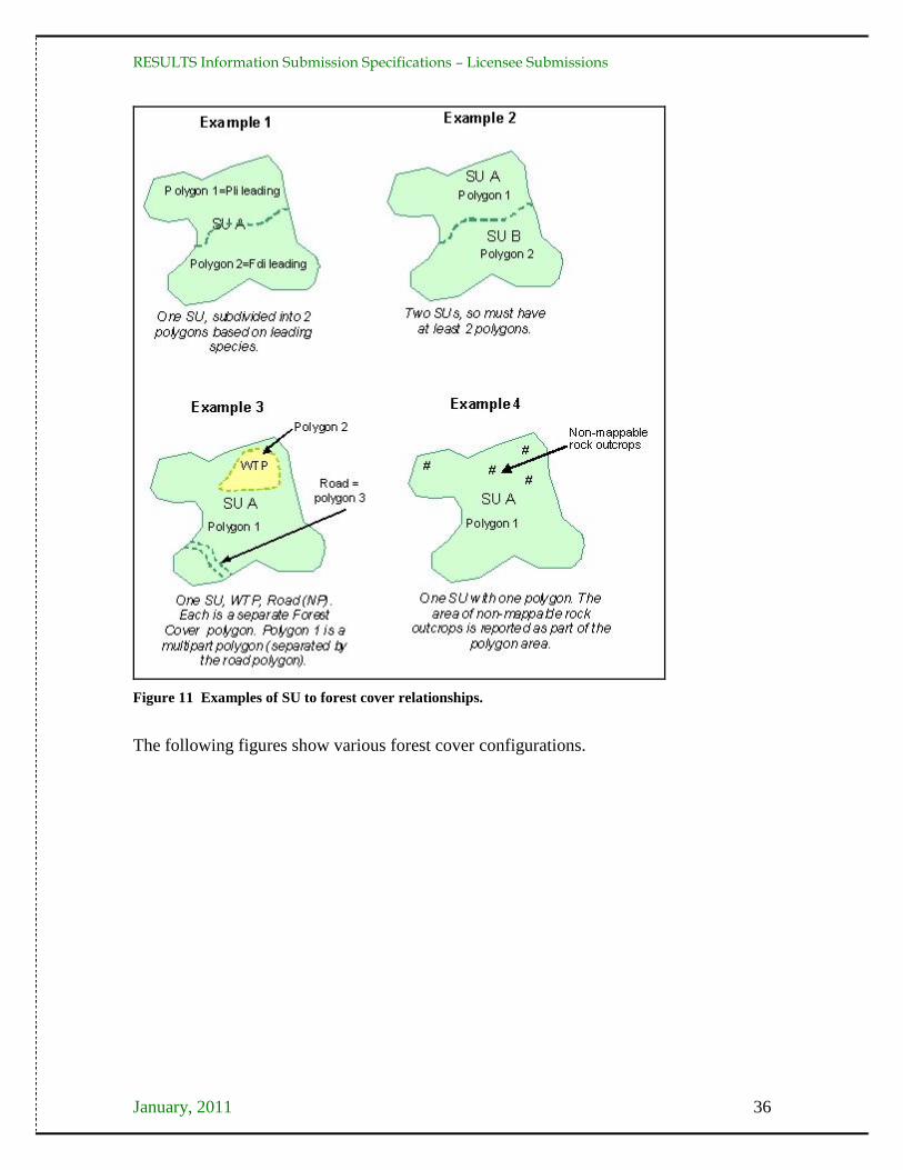
RESULTS Information Submission Specifications – Licensee Submissions
January, 2011 36
Figure 11 Examples of SU to forest cover relationships.
The following figures show various forest cover configurations.

RESULTS Information Submission Specifications – Licensee Submissions
January, 2011 37
Polygon Description Associated SU Area (ha)
A Clearcut 1 40.0
B WTP 5.0
C Roads 1 2.0
Figure 12 Opening comprised of three forest cover polygons. II) The productive area (NSRNAT), a
polygon with an internal hole. III) A multi-part polygon for the reserves (MATNAT). IV) A multi-part
polygon for the temporary access roads (NPUNN).
Polygon Description Associated SU Area (ha)
A Retention area 28.0
B Patch cuts and temporary
access road
1 18.0
Figure 13 Opening is a multi-pass silvicultural system with a planned re-entry. Comprised of patch
cuts with a surrounding retention area that will be available for a second pass. Two multi-part forest
cover polygons are included. II) The first polygon represents the unharvested retention (MATNAT). The
retention is classified as a Group Reserve with a TIM objective because it is subject to being available for a
second pass harvest prior to the end of the rotation (whether or not it becomes harvested). III) The second
polygon represents the harvested patches (NSRNAT) including the temporary access road which, in this
example, will be fully rehabilitated to the standards of SU1.
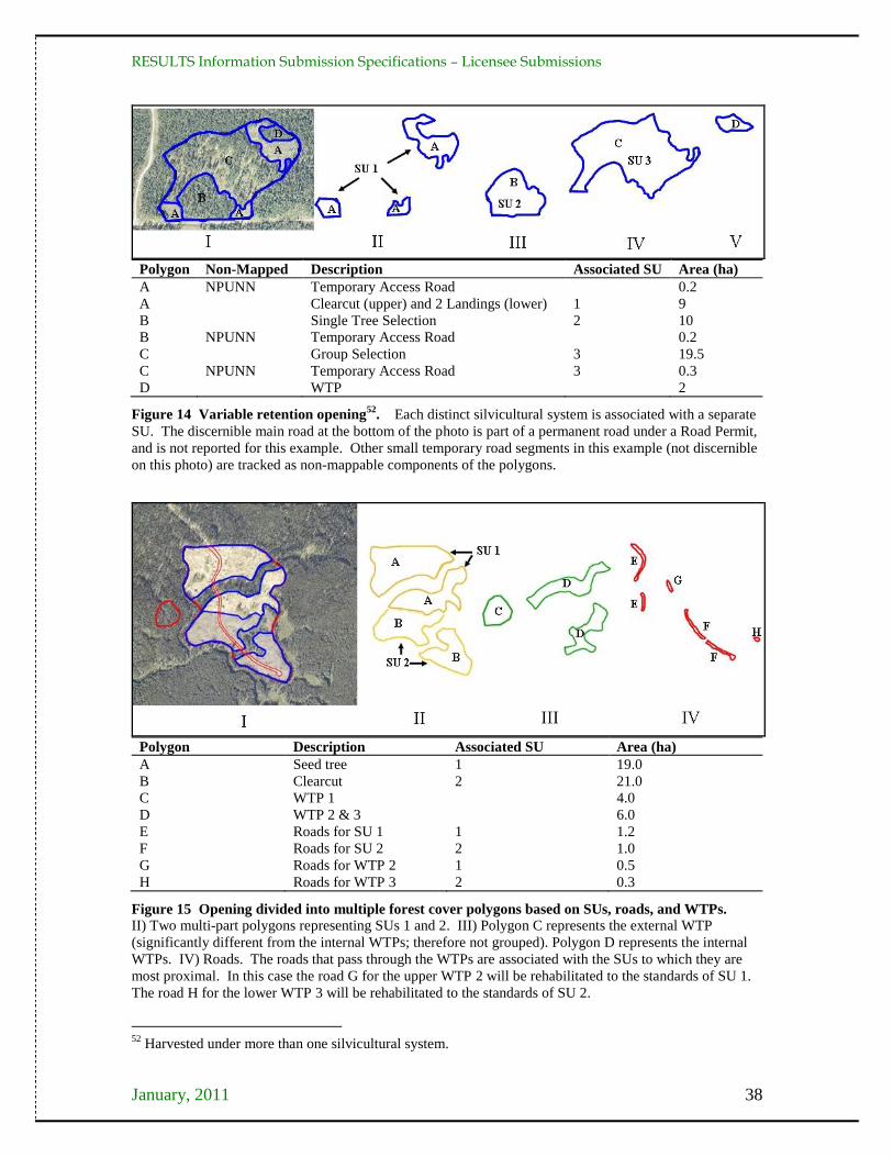
RESULTS Information Submission Specifications – Licensee Submissions
January, 2011 38
Polygon Non-Mapped Description Associated SU Area (ha)
A NPUNN Temporary Access Road 0.2
A Clearcut (upper) and 2 Landings (lower) 1 9
B Single Tree Selection 2 10
B NPUNN Temporary Access Road 0.2
C Group Selection 3 19.5
C NPUNN Temporary Access Road 3 0.3
D WTP 2
Figure 14 Variable retention opening52
. Each distinct silvicultural system is associated with a separate
SU. The discernible main road at the bottom of the photo is part of a permanent road under a Road Permit,
and is not reported for this example. Other small temporary road segments in this example (not discernible
on this photo) are tracked as non-mappable components of the polygons.
Polygon Description Associated SU Area (ha)
A Seed tree 1 19.0
B Clearcut 2 21.0
C WTP 1 4.0
D WTP 2 & 3 6.0
E Roads for SU 1 1 1.2
F Roads for SU 2 2 1.0
G Roads for WTP 2 1 0.5
H Roads for WTP 3 2 0.3
Figure 15 Opening divided into multiple forest cover polygons based on SUs, roads, and WTPs.
II) Two multi-part polygons representing SUs 1 and 2. III) Polygon C represents the external WTP
(significantly different from the internal WTPs; therefore not grouped). Polygon D represents the internal
WTPs. IV) Roads. The roads that pass through the WTPs are associated with the SUs to which they are
most proximal. In this case the road G for the upper WTP 2 will be rehabilitated to the standards of SU 1.
The road H for the lower WTP 3 will be rehabilitated to the standards of SU 2.
52
Harvested under more than one silvicultural system.
A
RESULTS Information Submission Specifications – Licensee Submissions
January, 2011 39
5.8. Milestone Declaration Report
Licensees may use the milestone declaration report to declare that 1) they have achieved
any of the following milestones: post-harvest, regeneration, free-growing, or no-
regeneration (for intermediate cuts subject to FPPR s. 44[4]); or, 2) their free-growing
obligations have been met to the extent practicable per FPPR s. 97.1. Declarations are
subject to review by MFR officials.
By declaring that a free-growing milestone has been met, licensees are, before further
examination by the ministry, deemed to have met the obligation. Milestone declaration
reports consist of attribute information, and are accompanied by current53
forest cover
reports (with attribute and spatial data)54
for the areas that are being declared.
Declarations can be made either as a submission to RESULTS through ESF, or as an
online update within RESULTS.
5.8.1. Timing
Milestone declarations are optional (FRPA s. 107; FPCBCA s. 162.1) and are submitted
any time after the applicable stocking standards have been met.
5.8.2. Attribute data
A given opening can have one or more milestone declaration reports.
Attribute field specifications are listed in Table 16.
53
As of the declaration date 54
If forest cover submissions have not already been submitted for the report period for areas being declared
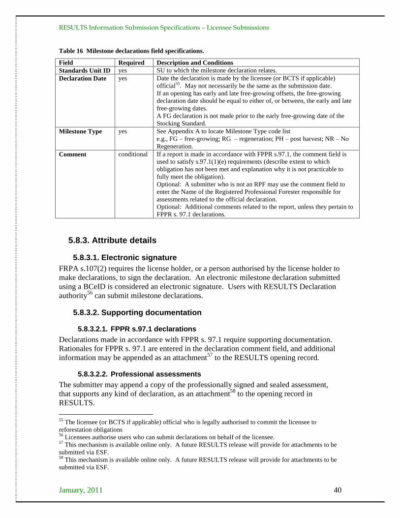
RESULTS Information Submission Specifications – Licensee Submissions
January, 2011 40
Table 16 Milestone declarations field specifications.
Field Required Description and Conditions
Standards Unit ID yes SU to which the milestone declaration relates.
Declaration Date yes Date the declaration is made by the licensee (or BCTS if applicable)
official55
. May not necessarily be the same as the submission date.
If an opening has early and late free-growing offsets, the free-growing
declaration date should be equal to either of, or between, the early and late
free-growing dates.
A FG declaration is not made prior to the early free-growing date of the
Stocking Standard.
Milestone Type yes See Appendix A to locate Milestone Type code list
e.g., FG – free-growing; RG – regeneration; PH – post harvest; NR – No
Regeneration.
Comment conditional If a report is made in accordance with FPPR s.97.1, the comment field is
used to satisfy s.97.1(1)(e) requirements (describe extent to which
obligation has not been met and explanation why it is not practicable to
fully meet the obligation).
Optional: A submitter who is not an RPF may use the comment field to
enter the Name of the Registered Professional Forester responsible for
assessments related to the official declaration.
Optional: Additional comments related to the report, unless they pertain to
FPPR s. 97.1 declarations.
5.8.3. Attribute details
5.8.3.1. Electronic signature
FRPA s.107(2) requires the license holder, or a person authorised by the license holder to
make declarations, to sign the declaration. An electronic milestone declaration submitted
using a BCeID is considered an electronic signature. Users with RESULTS Declaration
authority56
can submit milestone declarations.
5.8.3.2. Supporting documentation
5.8.3.2.1. FPPR s.97.1 declarations
Declarations made in accordance with FPPR s. 97.1 require supporting documentation.
Rationales for FPPR s. 97.1 are entered in the declaration comment field, and additional
information may be appended as an attachment57
to the RESULTS opening record.
5.8.3.2.2. Professional assessments
The submitter may append a copy of the professionally signed and sealed assessment,
that supports any kind of declaration, as an attachment58
to the opening record in
RESULTS.
55
The licensee (or BCTS if applicable) official who is legally authorised to commit the licensee to
reforestation obligations 56
Licensees authorise users who can submit declarations on behalf of the licensee. 57
This mechanism is available online only. A future RESULTS release will provide for attachments to be
submitted via ESF. 58
This mechanism is available online only. A future RESULTS release will provide for attachments to be
submitted via ESF.
RESULTS Information Submission Specifications – Licensee Submissions
January, 2011 41
5.8.3.3. Declarations by standards unit
Milestone declarations are submitted individually for each Standards Unit (SU) in an
opening. SU identifiers correspond with those in the opening definitions existing in
RESULTS. After all SUs in the opening have been declared free-growing, the Opening
Status is automatically reset to FG-Free-growing.
5.8.3.4. Milestone due dates
Milestone due dates are tracked in RESULTS based on the information submitted with
the opening definition. Due dates are displayed as the number of years from the
commencement of harvest. Due dates are blank for post-harvest, given no requirement to
submit post-harvest milestones for openings other than partial cuts or other intermediate
cuts. The commencement date for obligations is initiated by disturbance reporting which
is based on Opening Category. Commencement date for:
Current forest tenures (FTxx), is initiated by the disturbance reporting (harvest
start date usually, but harvest end date in the absence of regeneration obligations);
Natural disturbances (NDxx), is initiated by the opening approval date;
Backlog areas (BLxx), is initiated by the completion of the first non-survey
silviculture activity.
5.8.3.5. Forest cover updates
A current forest cover update is required when a milestone declaration is submitted
[FPPR s. 97(7)]. It can either be submitted together with other reports during the
reporting period, or in the same submission as the milestone declaration.
5.8.3.6. Post-harvest milestone declaration
Post-harvest milestone declarations may be used to declare the completion of harvest and
soil rehabilitation activities associated with soil disturbance or access structures
rehabilitation for any silvicultural system.
When post harvest has been declared on all SUs in an opening, the FTA cutblock status
for the opening automatically changes to S-Silviculture if it is not already set to that
status. Post-harvest declarations may be submitted after the completion of harvest
activities.
5.8.3.7. No-Regeneration milestone declaration
No-Regeneration milestone declarations may be used to declare that no outstanding
silviculture obligations exist on a polygon to which FPPR s.44(4) applies (e.g., for partial
cutting or other intermediate cuts such as commercial thinning, harvesting poles, or
sanitization). No-Regeneration milestone declarations are submitted no sooner than 12
months following the completion of harvest activities.

RESULTS Information Submission Specifications – Licensee Submissions
January, 2011 42
6. Spatial Data Format Spatial data submitted to RESULTS are formatted according to standards in this section.
6.1. General Mapping Standards
6.1.1. Scale
Base map is 1:20,000. Map boundaries originate from a 1:20,000 (or greater) map scale.
This scale corresponds with the scale of the Terrain Resource Information Management
(TRIM) map base. A map scale greater than 1:20,000 (e.g., 1:10,000 or 1:5000), does not
increase the positional accuracy of the spatial data with respect to the TRIM or
Vegetation Resources Inventory (VRI) map.
6.1.2. Position
Maps are checked for positional accuracy with 1:20,000 TRIM maps, and/or Vegetation
Resources Inventory (VRI) maps.
6.1.3. Accuracy
At the 1:20,000 scale, polygon boundaries must be within one millimetre of their true
North American Datum of 1983 (NAD83) map location (within 20 m of their true
location) (Figure 16). One tie point must be established within 10 m of its true NAD83
position for all traversed boundaries.
Figure 16 Relative positional accuracy overlay. This polygon is greater than 20 m from its true location.
This submission would fail.
The ministry considers (with few exceptions) more recent opening spatial data submitted
through the ESF to be more accurate, and better positioned, than spatial data for older
openings. This is noteworthy in situations where, for example, a recently submitted
RESULTS Information Submission Specifications – Licensee Submissions
January, 2011 43
opening definition that was GPS traversed overlaps a historical opening that was hand
traversed and may not be as well positioned, nor as accurate.
6.1.4. Minimum resolution
Minimum resolution refers to the degree to which closely related features can be
distinguished. Linear features (e.g., roads) should not be less than 10 m apart (some GIS
systems have difficulty processing smaller resolutions).
6.1.5. Units
The hectare (ha) is the acceptable unit.
6.1.6. Tolerance for differences between attribute and spatial area data
The tolerance for differences in area between what is submitted within the attribute data
and what is calculated from the spatial data is dependent on the size of the opening. For
openings less than 20 ha, the attribute data and the spatial data must be within the lesser
of 1 ha or 25% of the opening size. For openings greater than 20 ha, the attribute data and
the spatial data must be within 5% of the opening size.
6.2. Multi-part Geometry
Polygons, lines, and points are components of spatial information structure. In e-
Submissions, these simple geometries are extended to include multiple parts and internal
holes.
Multi-part geometry allows for a single feature (such as an SU) that is represented by two
spatially isolated polygons, to be represented in GML as a multi-part polygon. Multi-part
geometries are used to represent a single feature where gaps exist between some of the
feature parts. Multi-part polygons in GML are not structurally the same as utilizing two
polygons to represent a given feature. Attributes are stored only once in a submission for
any given feature represented by a multi-part geometry (i.e., a single SU that occurs in
different parts of an opening [see Figure 17]). If a single feature is represented by two
polygons (e.g., one SU described spatially by two polygons with duplicate attributes), the
RESULTS submission will fail.

RESULTS Information Submission Specifications – Licensee Submissions
January, 2011 44
Figure 17 Multi-part geometry. This opening (CP 101 Block 1) is represented by a multi-part polygon
for SU1 and a simple polygon for SU2, not by three separate polygons.
6.3. Spatial Topology
Topology refers to the structure and rules applied to create valid geometric objects that
are usable by the government for various analyses.
6.3.1. Polygon topology
A polygon is a closed shape that has a starting point equal to its end point and is
comprised of a minimum of three points or vertices (Figure 18).
Figure 18 A polygon.
A closed polygon has exactly the same coordinate for the start and end points. In some
Computer-aided Design (CAD) systems polygons are represented with lines. The start
and end point coordinates of each line forming the polygon match exactly. Lines forming
the polygon cannot overlap and the point of intersection is where the start and end points
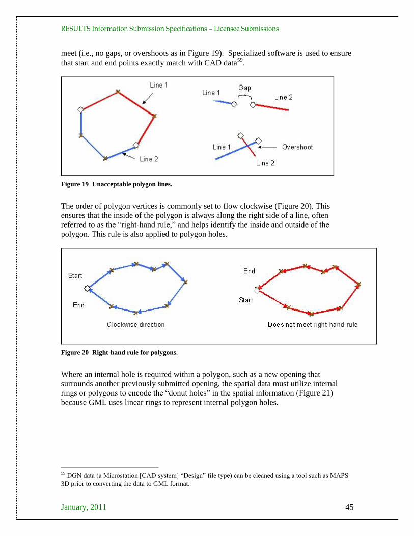
RESULTS Information Submission Specifications – Licensee Submissions
January, 2011 45
meet (i.e., no gaps, or overshoots as in Figure 19). Specialized software is used to ensure
that start and end points exactly match with CAD data59
.
Figure 19 Unacceptable polygon lines.
The order of polygon vertices is commonly set to flow clockwise (Figure 20). This
ensures that the inside of the polygon is always along the right side of a line, often
referred to as the ―right-hand rule,‖ and helps identify the inside and outside of the
polygon. This rule is also applied to polygon holes.
Figure 20 Right-hand rule for polygons.
Where an internal hole is required within a polygon, such as a new opening that
surrounds another previously submitted opening, the spatial data must utilize internal
rings or polygons to encode the ―donut holes‖ in the spatial information (Figure 21)
because GML uses linear rings to represent internal polygon holes.
59
DGN data (a Microstation [CAD system] ―Design‖ file type) can be cleaned using a tool such as MAPS
3D prior to converting the data to GML format.

RESULTS Information Submission Specifications – Licensee Submissions
January, 2011 46
Figure 21 Features cannot overlap. Where a polygon feature exists fully within another polygon, an
internal hole must be created in the larger polygon. Here the opening consists of three forest cover
polygons. The area covered by forest cover polygon 1 must not include the area covered by forest cover
polygon 2 so an internal hole is created. Similarly, forest cover polygon 2 must not include the area
covered by forest cover polygon 3 so another internal is created.
6.3.2. Linear topology
Lines are simple structures, consisting of a starting point and, at a minimum, an end
point. Direction of a line is determined by the location of starting and end points (Figure
22).
Figure 22 Line direction.
When creating directional information, ensure that lines do not intersect (Figure 23).
Figure 23 Lines must not intersect.
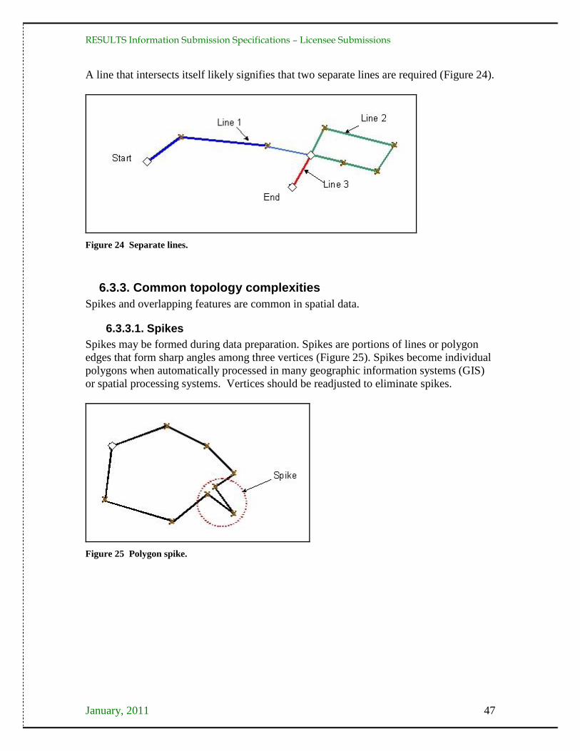
RESULTS Information Submission Specifications – Licensee Submissions
January, 2011 47
A line that intersects itself likely signifies that two separate lines are required (Figure 24).
Figure 24 Separate lines.
6.3.3. Common topology complexities
Spikes and overlapping features are common in spatial data.
6.3.3.1. Spikes
Spikes may be formed during data preparation. Spikes are portions of lines or polygon
edges that form sharp angles among three vertices (Figure 25). Spikes become individual
polygons when automatically processed in many geographic information systems (GIS)
or spatial processing systems. Vertices should be readjusted to eliminate spikes.
Figure 25 Polygon spike.

RESULTS Information Submission Specifications – Licensee Submissions
January, 2011 48
6.3.3.2. Overlapping features
In multiple geometrics, overlap can occur (Figure 26) and small slivers are formed
between geometrics. Where features follow a shared boundary, the vertices must be
identical in both geometrics to ensure no slivers or overlaps occur.
Figure 26 Polygon overlap.
When formatting shared boundaries in a CAD environment the same lines (a copy)
should be used to form a boundary between features (Figure 27).
Figure 27 Shared boundary.
In Microstation, using complex shapes to represent geometry causes difficulties with
shared boundaries between features. In such a case, it is recommended that polygons are
represented with lines.
6.3.4. Spatial data validations
Data that break standard topology rules such as self intersecting lines are rejected. To
avoid rejected submissions, data cleaning processes should be applied before submission.
Most GIS software have tools to detect and clean these conditions.
The MFR has upgraded to a spatial database technology with increased data resolution.
The new model is based on a tolerance of 0.005 meters or ½ of a millimetre. Any two
coordinates or any coordinate and a line segment within this tolerance range represent
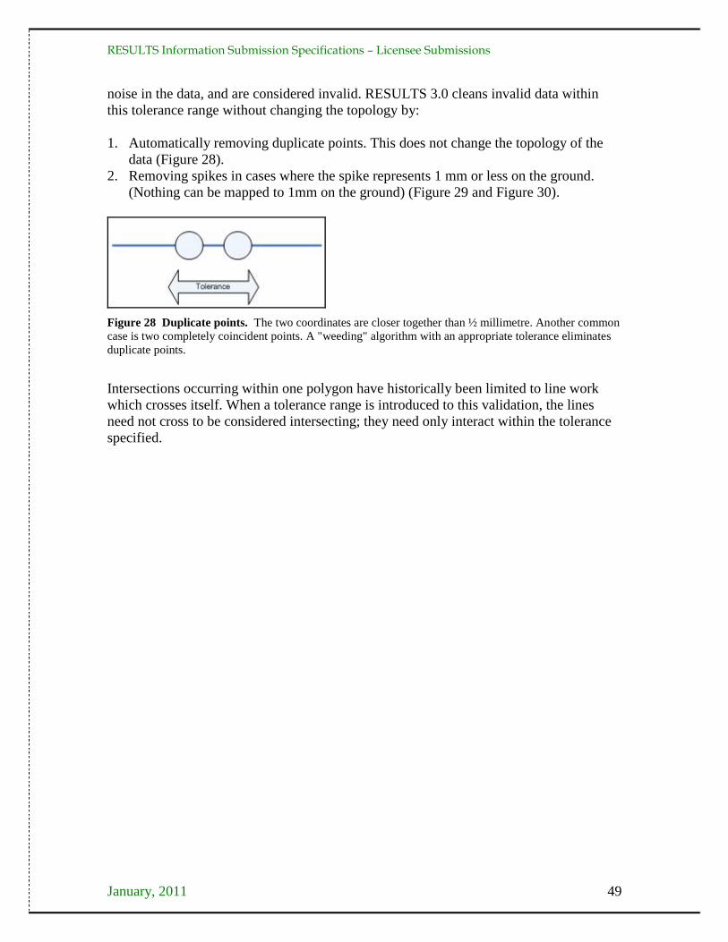
RESULTS Information Submission Specifications – Licensee Submissions
January, 2011 49
noise in the data, and are considered invalid. RESULTS 3.0 cleans invalid data within
this tolerance range without changing the topology by:
1. Automatically removing duplicate points. This does not change the topology of the
data (Figure 28).
2. Removing spikes in cases where the spike represents 1 mm or less on the ground.
(Nothing can be mapped to 1mm on the ground) (Figure 29 and Figure 30).
Figure 28 Duplicate points. The two coordinates are closer together than ½ millimetre. Another common
case is two completely coincident points. A "weeding" algorithm with an appropriate tolerance eliminates
duplicate points.
Intersections occurring within one polygon have historically been limited to line work
which crosses itself. When a tolerance range is introduced to this validation, the lines
need not cross to be considered intersecting; they need only interact within the tolerance
specified.

RESULTS Information Submission Specifications – Licensee Submissions
January, 2011 50
Figure 29 Self Intersecting Polygons. A: Situation where a vertex (blue) is less than the tolerance
distance away from another line segment. The dashed line shows the offending vertices. These situations
can be detected with most GIS software and conversion tools. Often caused by digitizing jitter or GPS
noise that is not cleaned after data capture. B: Similar example where the offending vertex is less than the
tolerance distance away from another line segment. C: A polygon where a very narrow area (less than or
equal to the tolerance) connects what appears to be two separate polygons. D: A multi-polygon where the
two polygon components are separated by less than the tolerance distance. Likely intended to be a single
polygon.
Figure 30 Self intersecting polygons. E: Vertex in a polygon hole is less than the tolerance distance
away from the exterior ring. Similar to examples C and D in Figure 29, applied to a different situation.

RESULTS Information Submission Specifications – Licensee Submissions
January, 2011 51
6.3.5. Topology and CAD systems
CAD systems, such as Microstation, do not support management of topology. For this
reason, if CAD systems are used to create maps for ESF submissions, standardization of
file creation and use of specialized software is required to configure topology. Topology
and structures are managed differently between CAD systems and GIS systems.
In Figure 31, Polygon A is formed by lines 1, 2, and 4 because they have the same level,
line weight and colour (other factors can be used to relate lines into polygons). Polygon B
cannot be created because colour, line weight, and level cannot be related to form a
polygon. Polygon B is difficult to determine, despite that it ―looks‖ right, given that line 3
is on a different level from all other lines. CAD attributes can be used with data
conversion tools to create topological relationships.
Figure 31 CAD Systems. Polygons can be represented in Microstation by using proper structure.
Several ways to create topological relationships in a CAD environment are possible, but
they require development and consistent application of standards. Organizations that use
CAD tools to map data for submission should consult an expert to create standards for
structures required to properly convert into GML.
6.4. Spatial Projections
Three general types of spatial projections are supported: Geographic (Latitude/
Longitude), Universal Transverse Mercator (zone 7, 8, 9, 10, 11 in metres), and Albers
Equal Area (BC Standards). For e-Submission documents, the projection information is
defined for each spatial object.

RESULTS Information Submission Specifications – Licensee Submissions
January, 2011 52
7. Precision Standards Precision standards identify the maximum differences allowed between licensee and
ministry estimates of a forest inventory/forest cover attribute or stratification. The
precision standards are measured by determining the difference between the data reported
by the licensee and data collected from a ministry survey60
of the same area. The
ministry may consider differences between the licensee estimate and the ministry
estimate of an attribute that exceed the required precision standard, as being in non-
compliance with form and manner specifications (FPPR s.86[6]).
The following minimum precision standards apply to forest inventory and forest cover
data submissions to RESULTS (Table 17). These standards should not be confused with
FIA or contract management standards.
Table 17 Minimum precision standards for data submissions.
Forest Inventory
Attribute Precision Standard for Data Submissions Comment
Inventory species
composition
Only trees identified as commerciala tree
species may be included in the composition.
Must correctly identify the leading species.
Estimate of individual species composition
percentages must be within 20% of the ministry
estimate.
Leading species is the tree species with
the greatest number of trees/ha.
Percent composition of immature tree
species is based on stems/ha.
Percent composition of mature trees is
based on basal area.
Silviculture species
composition
Only trees identified in the applicable stocking
standards for the SU may be included in the
silviculture species composition.
Estimate of individual species composition
percentages must be within 20% of the ministry
estimate.
Total trees/ha ± 20% of the ministry estimate
Well-spaced or free-
growing stems/ha
± 10% of the ministry estimate
Estimated stand age ± 20% of the ministry estimate
Estimated tree heights ± 20% of the ministry estimate
Site index ± 3 m of the ministry estimate
Estimated diameter ± 20% of the ministry estimate
Pest infection Absolute difference 10% in the estimate of
pest incidence between the reported and
ministry estimate is unacceptable.
e.g., an unacceptable difference is
where the reported estimate of pest
incidence is 2% and the ministry pest
incidence assessment is 13%. a See FIP data dictionary, page 140, for list of inventory commercial tree species.
http://www.for.gov.bc.ca/hts/vridata/standards/datadictionary/rpt_fip_rddv2.pdf.
60
Survey methods used by the ministry, and associated terminology definitions, for forest cover data are at
http://www.for.gov.bc.ca/his/results/business.htm#Survey_Methods.

RESULTS Information Submission Specifications – Licensee Submissions
January, 2011 53
Appendix A. Code Lists Code lists and combinations are at:
http://www.for.gov.bc.ca/his/results/webhelp/index.htm.
To access data Code lists:
1. Select RESULTS from the left vertical menu.
2. Then Code Table.
3. Then select the desired Code Table (Figure 32).
Figure 32 RESULTS Electronic Tech Specs Codes Lists
RESULTS Information Submission Specifications – Licensee Submissions
January, 2011 54
Appendix B. Definitions and Acronymns In these specifications:
“ABR” means as-built roads;
“BCeID” means British Columbia Electronic Identification, an electronic login identification that allows
private sector clients to access the BC government corporate reporting system;
“BEC system” means biogeoclimatic ecosystem classification system, a land classification system that
groups together ecosystems with similar climate, soils and vegetation (developed in British Columbia and
widely used as a framework for resource management and scientific research);
“CAD” means computer-aided design;
“CAM” means computer-aided mapping;
"Cutblock status" means a display only field in RESULTS that is populated with data that comes from
FTA, and which tracks the progession of the cutblock through the application/approval/silviculture
management phases of the cutblock lifecycle;
“CRS” means Corporate Reporting System;
“District Manager or designate” means District Manager or someone designated by the District Manager;
“e-FM” means Electronic Forest Management;
“ESF” means the Electronic Submission Framework, a combination of technology, tools, and a website
that allows clients of the Ministry of Forests and Range and of the Ministry of Sustainable Resource
Management to submit data electronically;
“e-Submission” means electronic submission;
“FDP” means Forest Development Plan under the FPCBCA;
“FIA” means Forest Investment Account;
“FTA” means Forest Tenure Administration system;
“FPC” means Forest Practices Code;
“FPCBCA” means Forest Practices Code of British Columbia Act;
“FPPR” means Forest Planning and Practices Regulation;
“FRPA” means Forest and Range Practices Act;
“FSP” means Forest Stewardship Plan under the FRPA;
“GIS” means geographic information systems;
“GML” means geography mark-up language;
“IDIR” means Information Directory, an electronic login identification that allows BC government
employees and their contractors to access the BC government corporate reporting system;

RESULTS Information Submission Specifications – Licensee Submissions
January, 2011 55
“ISIS” means Integrated Silviculture Information System, one of two silviculture information systems used
by MFR to track government-funded silviculture obligations prior to the development of RESULTS;
“licensee” means agreement holder under the Forest Act or BC Timber Sales Manager;
“ministry” means Ministry of Forests and Range;
“MLSIS” means Major Licensee Silviculture Information System, one of two silviculture information
systems used by MFR to track major licensee silviculture obligations prior to the development of
RESULTS;
“MFR” means Ministry of Forests and Range;
“NRFL” means non-replaceable forest licence;
“Offset” means a period (in years) between the commencement date of harvest operations and the
―regeneration date‖ or ―free-growing date‖ 1) as defined by the FPPR; or, 2) within the context of the
OSPR stocking requirements.
"Opening status" means the administrative stage within the life cycle of an opening. The status
determines what kinds of reports can be submitted to RESULTS with respect to that opening.
“OSPR” means Operational and Site Planning Regulation;
“primary harvesting activities” means falling and yarding;
“RESULTS” means the Reporting Silviculture Updates and Land Status Tracking System online
application and database, used by the ministry to track silviculture information by managing the submission
of reports related to openings, disturbances, silviculture activities, forest cover, and obligation declarations
as required by Forest and Range legislation;
“RPF” means Registered Professional Forester as defined by the Association of British Columbia Forest
Professionals and the Forester’s Act;
“Silviculture Prescription” means Silviculture Prescription according to section 22.1 of the FPC;
“Standards Unit” means standards unit as defined by the FPPR;
“THSPR” means Timber Harvesting and Silviculture Practices Regulation;
“TRIM” means the BC government Terrain Resource Information Management program;
"User" means a person employed by a ministry client, or the ministry, to load data into RESULTS";
“VRI” means the BC government Vegetation Resources Inventory database;
“WTP” means wildlife tree patch;
“XML” means extensible mark-up language.

RESULTS Information Submission Specifications – Licensee Submissions
January, 2011 56
Appendix C. Tracking Reserves Track each reserve as a polygon with information summarised in Table 18.
Table 18 Reserve tracking summary
Field Required
- All reserves
Applicable Portion of a reserve
associated with a SU:
D-Denuded or R-Residual
ALL RESERVES
Polygon ID (for each reserve) Polygon area Reserve type code (G or D) Reserve objective code (RMA, WTR, TIM, etc..) Site index , D, R
Site index source code , D, R
Stocking status/type (typically MAT/NAT or IMM/NAT) , D, R
Reference year , D, R
Tree cover pattern , R
DISPERSED RESERVES (ASSOCIATED WITH SU)
SU ID Forest Cover Layer code D, R
Species by percent (silv. comp.) D
Height of leading species (silv. comp.) D
Age of leading species (silv. comp.) D
Well-spaced stems/ha61
(silv. comp.) D
Free-growing stems/ha62
(silv. comp.) D
Damage Agent, %Incidence, and Area Affected63
(silv. comp.) D
Species by percent (inv. comp.) D, R
Height of leading species (inv. comp.) D, R
Age of leading species (inv. comp.) D, R
Total stems/ha (inv. comp.) D, R
Crown closure (inv. comp.) D, R
Basal area if available (inv. comp.) R
Damage Agent, %Incidence, and Area Affected64
(inv. comp.) R
GROUP RESERVES (NOT ASSOCIATED WITH SU)
Forest Cover Layer code R
Species by percent (inv. comp.) R
Height of leading species (inv. comp.) R
Age of leading species (inv. comp.) R
Total stems/ha (inv. comp.) R
Crown closure (inv. comp.) R
Basal area if available (inv. comp.) R
Damage Agent, %Incidence, and Area Affected65
(inv. comp.) R
61
If specified in the Silviculture Prescription/FDP/FSP; otherwise optional (recommended) 62
If specified in the Silviculture Prescription/FDP/FSP; otherwise optional (recommended) 63
If damage agent present 64
If damage agent present 65
If damage agent present