results of regional satellite user survey in ra iii/iv · 24 mexico instituto de ciencias del mar y...
TRANSCRIPT

WORLD METEOROLOGICAL ORGANIZATION
___________________________
COMMISSION FOR BASIC SYSTEMS OPEN PROGRAMME AREA GROUP ON INTEGRATED OBSERVING SYSTEMS
INTER-PROGRAMME EXPERT TEAM ON SATELLITE UTILIZATION AND
PRODUCTS
SECOND SESSION
GENEVA, SWITZERLAND, 23-26 FEBRUARY 2016
IPET-SUP-2/Doc. 12.1 (11.II.2016) _________ ITEM: 12 Original: ENGLISH
RESULTS OF REGIONAL SATELLITE USER SURVEY IN RA III/IV
(Submitted by Diego Souza and Luiz A.T. Machado, INPE)
Summary and Purpose of Document This document presents the draft report of the 2015 Satellite Data User Survey for Regions III (South America) and IV (North America, Central America, and the Caribbean), carried out under the auspices of the WMO Coordination Group on Satellite Data User Requirements in Regions III and IV. 31 institutions answered the survey from 23 countries, from 10 countries in Region III and 13 countries from Region IV.
An update of the satellite data requirements table was produced as a result of the Survey, with indication of user priorities.
ACTION PROPOSED
The second session is invited to: (a) Take note and evaluate the answers from the regions; (b) Define the next steps including the survey publication mechanism; (c) Provide strategic advice to improve satellite data utilization and priority-setting of user
requirements in RA III/IV.
______________________

IPET-SUP-2/Doc. 12.1, p. 2
DISCUSSION 1. INTRODUCTION AND PARTICIPATION IN THE SURVEY (Q1) This document presents the draft report of the 2015 Satellite Data User Survey for Regions III and IV, carried out under the auspices of the WMO Coordination Group on Satellite Data User Requirements in Regions III and IV. The main goal of this survey was to have information to establish a strategic plan and refine the roadmap to improve satellite utilization in the region taking into account the new satellite generation, the potential use of GNC-A and the discontinuation of the EumetCast services in the Region. The survey results show a clear picture of the needs of the region and provide a valuable material to SDR and NOAA to prepare a satellite utilization plan for new satellite generation and data dissemination in RA III/IV. For instance, 68% of the institutions receive satellite data-products by internet. Based on the total amount of data generated by the future satellite generation, this procedure could be a limitation. The survey provides information about the needs of training, the conversion of EumetCast station to GeoNetcast stations and the expectations with regard to GEONetcast. 31 questionnaires were answered by institutions from 23 countries, from which 10 countries were from RAIII (Argentina, Bolivia, Brazil, Chile, Colombia, Ecuador, Guyana, Paraguay, Peru and Uruguay) and 13 countries from RAIV (Antigua and Barbuda, Aruba, Barbados, Belize, Canada, Cayman Islands, Costa Rica, El Salvador, Mexico, Saint Lucia, St. Kitts and Nevis, St. Vincent and the Grenadines and Trinidad and Tobago), as seen on table 1. Table 1: Answers by country
Answers by Country
Country Region Answers
Antigua and Barbuda IV (N&C America & Caribbean) 1
Argentina III (S America) 5
Aruba IV (N&C America & Caribbean) 1
Barbados IV (N&C America & Caribbean) 1
Belize IV (N&C America & Caribbean) 1
Bolivia III (S America) 1
Brazil III (S America) 2
Canada IV (N&C America & Caribbean) 1
Cayman Islands IV (N&C America & Caribbean) 1
Chile III (S America) 2
Colombia III (S America) 2
Costa Rica IV (N&C America & Caribbean) 1
Ecuador III (S America) 1
El Salvador IV (N&C America & Caribbean) 1
Guyana III (S America) 1
Mexico IV (N&C America & Caribbean) 2
Paraguay III (S America) 1
Peru III (S America) 1
Sait Lucia IV (N&C America & Caribbean) 1
St. Kitts and Nevis IV (N&C America & Caribbean) 1
St. Vincent and the Grenadines IV (N&C America & Caribbean) 1
Trinidad and Tobago IV (N&C America & Caribbean) 1
Uruguay III (S America) 1 Total 31

IPET-SUP-2/Doc. 12.1, p. 3
18 answers were provided from national meteorological and hydrological services, 9 answers from research institutions, 3 answers from space agencies and 3 answers were from universities. The table 2 shows the name of the organizations that answered the survey along with their assigned ID # (identification number) referred throughout the compilation results. Table 2: Organizations that answered the survey ID # Q1A – Country Q1B - Organization
1 Antigua and Barbuda Meteorological Services
2 Argentina Comisión Nacional de Actividades Espaciales - CONAE
3 Argentina Facultad de Agronomia de Buenos Aires
4 Argentina Servicio de Hidrografia Naval
5 Argentina Servicio Meteorologico Nacional - SMN
6 Argentina Unidad de Geocriología de IANIGLA - CONICET
7 Aruba Departamento Meteorologico Aruba
8 Barbados Caribbean Institute for Meteorology and Hydrology
9 Belize National Meteorological Service
10 Bolívia Servicio Nacional de Meteorología e Hidrologia - SENAMHI
11 Brazil Instituto Nacional de Meteorologia - INMET
12 Brazil Instituto Nacional de Pesquisas Espaciais - INPE - CPTEC - DSA
13 Canada Meteorological Service of Canada
14 Cayman Islands National Weather Service
15 Chile Dirección Meteorológica de Chile
16 Chile Universidad de la Serena
17 Colombia Corp. Cent. de Inv. Cient. del Rio Magd. Alf. Palacio Rudas - CIRMAG
18 Colombia Dirección Técnica Ambiental
19 Costa Rica Instituto Meteorologico Nacional
20 Ecuador Instituto Nacional de Meteorología e Hidrología
21 El Salvador Ministerio de Medio Ambiente y Recursos Naturales – MARN
22 Guyana National Weather Watch Centre
23 Mexico Agencia Espacial Mexicana
24 Mexico Instituto de Ciencias del Mar y Limnologia - UNAM
25 Paraguay Dirección de Meteorología e Hidrología - DINAC
26 Peru Servício Nacional de Meteorología e Hidrologia - SENAMHI
27 Saint Lucia Saint Lucia Meteorological Services
28 St. Kitts and Nevis St. Kitts Meteorological Services
29 St. Vincent and the Grenadines
E.T. Joshua Airport
30 Trinidad and Tobago Trinidad and Tobago Meteorological Service
31 Uruguay Universidad de la Republica
The compilation of the results was conducted by Diego Souza and Luiz Machado, from INPE, Brazil.

IPET-SUP-2/Doc. 12.1, p. 4
2. DATA REQUIREMENTS KNOWLEDGE AND APPLICATION (Q2) Most institutions participating in the survey (55%) did not know the Satellite Data Requirements for RA III and RA IV. If we consider only the number of countries, 12 (52%) already knew it and 11 (48%) do not. This was expected, since in most cases only one institution from each country participates in the SDR meetings.
Figure 1: Data Requirements knowledge Table 3: Comments for Question 2
ID # Comments
4 No, the DHN Meteorology Department do not receive such information or news on this subject
23 No, but this is high valuable information From all 31 answers, 25 institutions (81%) have filled the Data Requirements table with their product priorities. The new Table of Data Requirements including the data priority table can be found at http://satelite.cptec.inpe.br/geonetcast/br/datareq.html.

IPET-SUP-2/Doc. 12.1, p. 5
Figure 2: Number of institutions that filled in the SDR priorities table Considering the data availability related questions (Q2C and Q2D), only one institution indicated other relevant products which are not present in the table that they would like to be disseminated in the region, and 3 institutions included the products generated by them to be broadcast through the GEONETCast-Americas system.

IPET-SUP-2/Doc. 12.1, p. 6
3. DATA ACCESS AND USAGE (Q3, Q4 and Q5A-B) The Region is mostly using satellite data for weather forecasts and warnings (81%), followed by disaster mitigations and preparedness (71%), research and development (65%), hydrological forecasts, warnings and assessments (65%) and climate predictions and assessments (52%). Besides glaciological assessments, no other use has been specified. Table 4: Main use of satellite data
Q3 - What is your main use of satellite data? Answers % %
Weather forecasts and warnings 25 81 0,81
Disaster mitigation and preparedness 22 71 0,71 Hydrological forecasts, warnings and assessments 20 65 0,65
Research and development 20 65 0,65
Climate predictions and assessments 16 52 0,52
Land monitoring (e.g., for agriculture) 15 48 0,48
Education and training 15 48 0,48
Environmental assessments 13 42 0,42
Oceanography and marine meteorology 11 35 0,35
Socio-economic mapping 3 10 0,10
Space weather applications 2 6 0,06
Other (please specify) 2 6 0,06
Q3 - Others specified Answers
Glaciological assessments 1
Figure 3: Main use of satellite data With regards to the data latency, 6% of the institutions are interested in data from the two last days, 12% of the institutions are interested only in historical data, 21% in real time data and 61% indicated that all are equally important for them. An optimized regional data distribution and dissemination system should consider this, providing a comprehensive and well documented set of products with ease of access for near-real time data and a reliable database for historical data.

IPET-SUP-2/Doc. 12.1, p. 7
Figure 4: Data timeliness Most institutions are currently accessing satellite data from the internet (68%), through ftp or http. There is considerable use of direct readout systems like GOES GVAR (48%) and POES HRPT (19%). The DVB-S retransmission systems such as GEONETCast-Americas (19%) and EUMETCast-Americas (19%) also have a good number of users, and are slowly gaining interest over the region, as it happened in other regions of the world, especially in Region VI. Table 5: Satellite data access
Q5A - How do you currently receive and access satellite data? Answers %
Internet (ftp, http) 21 68
GOES GVAR 15 48
POES HRPT 6 19
DVB-S/S2: GEONETCast-Americas 6 19
DVB-S/S2: EUMETCast-Americas 6 19
Metop AHRPT 4 13
Other (please specify) 4 13
GTS point-to-point 3 10
GOES DCS 2 6
GOES LRIT 1 3
GOES EMWIN 1 3
POES APT 0 0
NWS ISCS 0 0
Q5A - Others specified Answers
UCLAR LDM 1
NPP/TERRA/AQUA 1

IPET-SUP-2/Doc. 12.1, p. 8
Figure 5: Current satellite data access mechanism A considerable number of institutions gave details on their reception system, as shown in table 4. For the GOES-GVAR direct readout stations, the hardware and software providers SeaSpace, Dartcom and Quorum are prominent. As for the internet access, the webpages from NASA, CIRA and NOAA-CLASS are the most used.

IPET-SUP-2/Doc. 12.1, p. 9
Table 6: Details on the reception system being used ID # GOES-GVAR
5 Ground station from SeaSpace with the TeraScan software
11 Antenna
12 SeaSpace ingestion system with a 3.6 m antenna
13 5.0 m antennas at 7 locations
15 System provided by SeaSpace
21 Through McIDAS-V
25 Antenna
26 Antenna, Receiver, IDAP software, MacroPro and GVAR-Ingester
ID # GOES-DCS
11 Antenna
13 Use for upload of hydrographic station
ID # POES-HRPT
5 Ground Station from Quorum - NOAA AVHRR
11 Antenna
12 Dartcom ingestion system with a 1.5 m antenna
13 2.4 m antennas at 4 locations
15 System provided by SeaSpace
ID # METOP-AHRPT
11 Antenna
12 Dartcom ingestion system with a 1.5 m antenna
13 2.4 m antennas at 4 locations
ID # Internet
15 Free-access web-pages with no cost involved
18 NOAA web-page
21 Historical data from CLASS
22 NASA and CIRA web-pages
25 National weather service’s web-page
26 Images from NASA web-page
31 GOES raw images from CLASS
ID # GEONETCast-Americas
5 Planned the acquisition for 2016-2017
12 2.4 m antenna
ID # EUMETCast-Americas
11 Antenna
12 3.2 m antenna
25 Antenna
ID # Other
4 NOAA receiving antenna on vessels
7 UCLAR LDM
12 NPP/TERRA/AQUA As plans for the near future, the GEONETCast-Americas system is the option considered by most institutions (58%). This result shows the preferable choice for a low cost, user driven global network of a satellite-based dissemination system like GEONETCast. Apart from the options given in the survey, UCLAR LDM, NPP and AR-III VPN systems were also specified by users.

IPET-SUP-2/Doc. 12.1, p. 10
Table 7: Satellite data receiving mechanism for the future
Q5B - How do you plan on receiving satellite data in the future? Answers %
DVB-S/S2: GEONETCast-Americas 18 58
GOES GRB 17 55
Internet (ftp, http) 15 48
GOES DCS 5 16
POES HRPT 5 16
GOES LRIT 4 13
Metop AHRPT 4 13
GTS point-to-point 4 13
Other (please specify) 4 13
GOES EMWIN 2 6
POES APT 0 0
NWS ISCS 0 0
Q5B - Others specified Answers
UCLAR LDM 1
NPP/TERRA/AQUA 1
AR-III VPN 1
Figure 6: Preferred satellite data receiving mechanism for the future On the question details, users showed interest on receiving GOES-R, METOP and products developed by other institutions through GEONETCast-Americas. Also, with the end of the EUMETCast-Americas service, a user showed interest on receiving EUMETSAT data through the internet. Table 8: Details on the reception system intended to be used in the future
ID # GOES-GRB
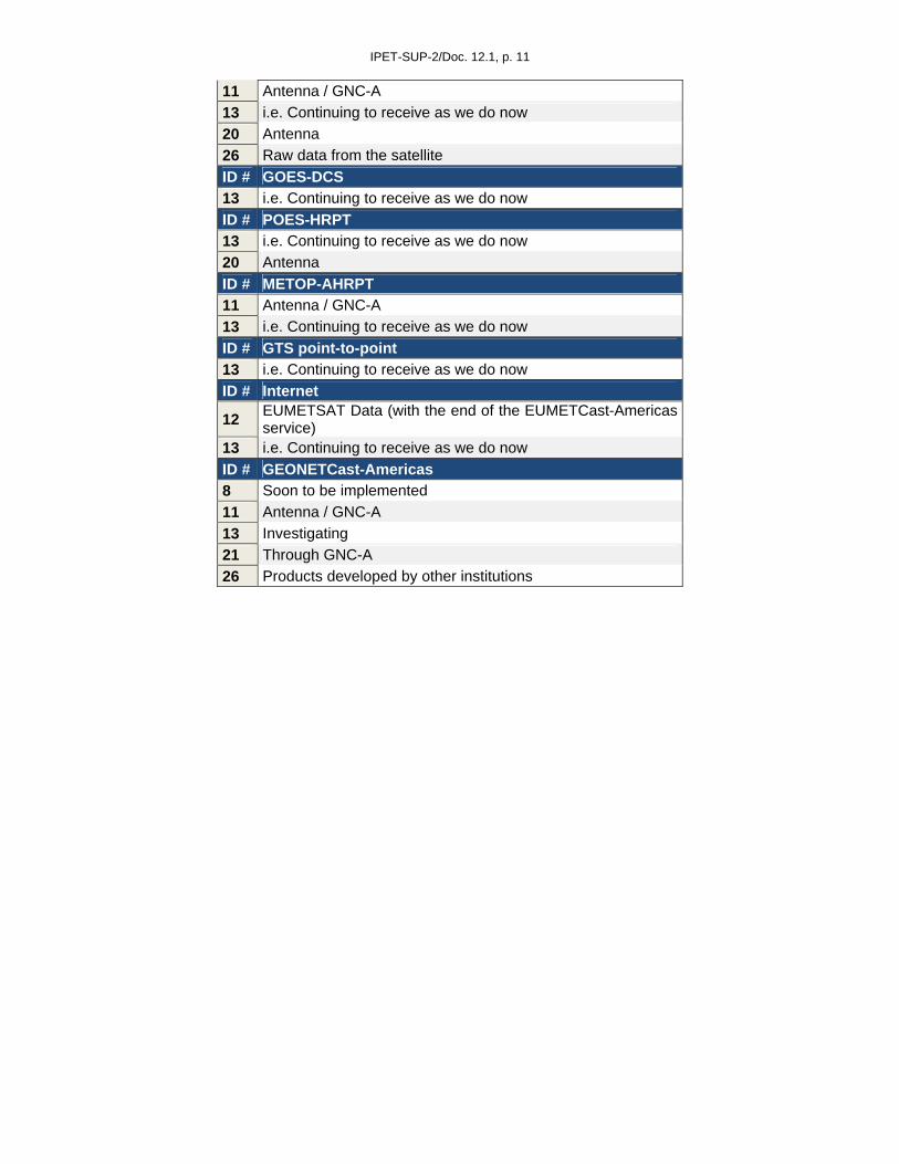
IPET-SUP-2/Doc. 12.1, p. 11
11 Antenna / GNC-A
13 i.e. Continuing to receive as we do now
20 Antenna
26 Raw data from the satellite
ID # GOES-DCS
13 i.e. Continuing to receive as we do now
ID # POES-HRPT
13 i.e. Continuing to receive as we do now
20 Antenna
ID # METOP-AHRPT
11 Antenna / GNC-A
13 i.e. Continuing to receive as we do now
ID # GTS point-to-point
13 i.e. Continuing to receive as we do now
ID # Internet
12 EUMETSAT Data (with the end of the EUMETCast-Americas service)
13 i.e. Continuing to receive as we do now
ID # GEONETCast-Americas
8 Soon to be implemented
11 Antenna / GNC-A
13 Investigating
21 Through GNC-A
26 Products developed by other institutions

IPET-SUP-2/Doc. 12.1, p. 12
4. GEONETCast-AMERICAS AND EUMETCAST-AMERICAS (Q6 and Q7A-C) Most users (56%) answered that their country would consider cover the cost needed to install a GEONETCast-Americas station (approximately USD 5000,00). Part of the users (28%) already has a station. Also, part of the community (19%) has not answered this question (some of these commented that they do not know the system). On the comments related to this question, some users affirmed that funding and purchase bureaucracy are the main obstacles.
Figure 7: Countries considering covering the cost for a GEONETCast-Americas installation Table 9: Comments for Question 6
ID # Comments
1 Yes, we would pursue as become necessary
2 CONAE already has a GNC-A station
4 Yes, we would be willing, although with the cost involved is necessary to generate a bidding process or a special purchase process. I think this would be difficult
5 Yes, we have scheduled the purchase of 1 (one) station to the end of 2016
6 Argentina already has a station
8 Yes, CIMH is a regional organization and has partnered with NOAA to acquire a GNC receiving station soon to be operational
9 Already have GEONETCast
12 We already have a station
16 We already purchased one
19 Costa Rica has three operational antennas
20 Yes, but we do not have the necessary funds
23 Mexico already counts with 10 GNC-A stations
26 We are in the process of acquiring the required components (KenCast software, DVB-S2 receiver, etc) for the implementation of a GNC-A station at our institution
29 Unsure
31 Yes, but funds are not available at the moment The majority of users that have a EUMETCast-Americas station would consider converting it to a GEONETCast-Americas station, giving continuity to their DVB-S reception mechanism, as shown in

IPET-SUP-2/Doc. 12.1, p. 13
figure 8. A slight majority of the users that answered the survey are not EUMETCast users (52%). Only 3% would not consider converting their stations.
Figure 8: EUMETCast-Americas to GEONETCast-Americas conversion Table 10: Comments for Question 7A
ID # Comments
5 We are not a EUMETCast-Americas user, but we have part of the hardware to convert our station to GEONETCast-Americas. SMN stated working on the conversion
17 Subjected to budget availability this year
26 We are currently in the process From the 45% of users that have a EUMETCast-Americas station from the questionnaire answers, 26% affirmed that they need the data broadcast through the system in near-real time. Most of them specified the data and applications needed, as seen on table 11.
Figure 9: Necessity of data disseminated through EUMETCast-Americas Table 11: Comments for Question 7B

IPET-SUP-2/Doc. 12.1, p. 14
ID # Data ID # Application
2 Calibrated SEVIRI bands 6 Geocryology
6 Snow Cover - Weather - Landscape 10 Monitoring of the upper, lower and middle atmosphere and verification of dynamic models
10 PP, TX, TN 11 Weather monitoring / prediction
11 HRIT 12 Nowcasting, Weather Monitoring
12 HRIT 15 minutes 17 Hydrological Modeling
17 Precipitation, Solar Radiation, Temperature 18 Software to receive all environmental components
18 Weather and Environmental Data 20 Weather forecast For approximately half of these users (20%), the reception of SEVIRI data with three hours of delay would be sufficient, as seen in figure 10. One user stated that this would be sufficient provided they have additional information for their given region of interest.
Figure 10: Sufficiency of SEVIRI data with 3 hours of delay Table 12: Comments for Question 7C
ID # Comments
10 Yes, provided we have additional information
20 No, it would be necessary the lower latency as possible 5. CAPACITY BUILDING AND TRAINING (Q8 – Q13) Most institutions answered that their country would consider covering the costs to send employees for training in Regional Centers for longer periods (48%). It is clear that the great obstacle for the institutions is the cost involved, as a great part of them informed this on the comments seen on table 11.

IPET-SUP-2/Doc. 12.1, p. 15
Figure 11: Employees training in Regional Centers for longer periods Table 13: Comments for Question 8
ID # Comments
4 Yes. The difficulty always lies in costs. But we have the availability of personnel to do so7 No. Aruba is a small island state
8 Yes. CIMH is a regional organization. Professional development activities are supported as resources permit
10 Not at the moment, but it would be a good alternative for the formation of adequately trained human resources
15 No. While there is interest in participating in training, it is usually difficult to fund these activities internally
17 Yes, but subjected to budgetary availability for the year in question 20 No, for lack of economic factor 21 No, there are no funds allocated in this regard 23 No, we propose that the GNC-A training should take place on Mexico 25 No, we do not have the budget 31 Yes, but not my institution at this moment
The users also prioritized the capacity building areas that they need the most. Capacity building activities related to satellite imagery is the greatest need (55%), followed by clouds (39%), winds (35%), soundings (32%) and aerosols (32%). Table 14: Capacity building areas prioritization

IPET-SUP-2/Doc. 12.1, p. 16
Q9 - Please prioritize the following capacity building areas Answers %
Imagery 17 55
Clouds 12 39
Winds 11 35
Soundings 10 32
Aerosols/Air Quality/Atmospheric Chemistry 10 32
Hydrology 9 29
Lightning 9 29
Aviation 7 23
Land 7 23
Cryosphere 7 23
SST and Ocean Dynamics 6 19
Radiation Budget 3 10
Space Environment 1 3
Other (please specify) 0 0
Figure 12: Capacity building areas prioritization

IPET-SUP-2/Doc. 12.1, p. 17
As for the educational applications and softwares, the COMET Program is the most known (61%), followed by McIDAS-V (55%), WMO VLab (45%), ILWIS (39%), GOES-R Education Page (26%), NOAA CLASS (19%), WMO-SATURN (16%) and CSPP (10%). Other softwares and platforms were specified, like SOPI, NASA Worldview, EUMETRAIN, NCL, ESRI, GrADS and GEMPAK, as seen on table 15. Table 15: Educational applications / softwares know by the community
Q10 - Do you know the following educational applications/software, etc.? Answers %
COMET 19 61
McIDAS-V 17 55
VLab 14 45
ILWIS. 12 39
http://www.goes-r.gov/education/overview.html 8 26
CLASS 6 19
Other (please specify) 6 19
SATURN-WMO 5 16
CSPP/IMAPP (SSEC) 3 10
Q10 - Others specified Answers
SOPI 1
NASA: Worldview EOSDIS 1
EUMETrain 1
NCL 1
ESRI 1
GrADS 1
GEMPAK 1
Figure 13: Educational applications/software knowledge

IPET-SUP-2/Doc. 12.1, p. 18
Most institutions would consider organize local theoretical courses (58%) and local training workshops (69%). The economic factor is a key obstacle for those with a negative answer, as seen on tables 16 and 17. In the other hand, 90% of the institutions consider giving time to their employees for virtual training.
Figure 14: Local theoretical courses consideration
Figure 15: Local training workshops consideration
Figure 16: Virtual training consideration
Table 16: Comments for Question 11

IPET-SUP-2/Doc. 12.1, p. 19
ID # Comments
4 Yes, but it depends on the cost involved
8 Yes, CIMH is a WMO CoE in Satellite Meteorology and a WMO VLab CoE
10 No, due to the lack of funding
12 Yes, we are a WMO CoE
20 Yes, but we need to consider the economic factor
21 No, there are no funds allocated in this regard Table 17: Comments for Question 12
ID # Comments
4 Yes, but it depends on the cost involved
8 Yes, CIMH is a WMO CoE in Satellite Meteorology and a WMO VLab CoE
10 No, for now it becomes difficult due to the lack of budget
12 Yes, we are a WMO CoE
20 Yes, but due to the lack of budget it is not done
21 No, there are no funds allocated in this regard Table 18: Comments for Question 13
ID # Comments
4 Yes, we currently participate in all virtual activities we can
8 Yes, CIMH is a WMO CoE in Satellite Meteorology and a WMO VLab CoE
21 Yes, actually some employees attend virtual courses

IPET-SUP-2/Doc. 12.1, p. 20
6. JPSS - Joint Polar Satellite System (Q14 – Q14G) Most institutions intend to use JPSS data (48%), as seen on figure 17. According to the comments, part of the institutions needs more information about the platform. A considerable part of the institutions (23%) hasn’t answered this question, showing that most of them are probably not aware of the system.
Figure 17: Intention to use JPSS data Table 19: Comments for Question 14
ID # Comments
1 No decision yet
4 Yes, they are of fundamental importance for Antarctic operations of the Argentina Navy
8 Yes, CIMH is working with NOAA through CIRA and hope the acquire access to JPSS data
10 No, for the lack of information about the platform, its resolution and frequency
11 Yes, our station is enabled for receiving this data
20 Yes, but equipment is needed
21 Yes, depending on the extent of the format and data availability
22 I am not aware of the system. More information is needed
31 No, there are no concrete plans at this moment In the other hand, most institutions do not intend to buy a JPSS station (52%). Among the justifications are the use of information available on-line, the need for more information about the system and the cost factor. The number of institutions that have not answered this question is in accordance to question 14.

IPET-SUP-2/Doc. 12.1, p. 21
Figure 18: Intention to acquire a JPSS direct readout station Table 20: Comments for Question 14A
ID # Comments
1 Will attempt to acquire the most cost-effective solution
2 Probably will be purchased, but not planned for now
4 Yes, we're in the process of the acquisition of receiving systems for vessels
5 Yes, we're in the purchase process. In principle we'll receive NPP, TERRA, AQUA, NOAA and METOP data
7 No, we'll use UCLAR LDM
8 No. It may depend on future cost and regional and international support
10 No, we'll use information available on-line
11 Yes, our station is enabled for receiving this data
13 Yes, we're already prepared as we are receiving NPP
16 Yes. We would like to know the characteristics of the station and then propose the purchase to the university
18 No. We're going to use GEONETCast
20 No. We use GOES
21 No, we do not have enough information about it
27 Yes, within the next 5 years if budget allow Most institutions answered what are the most important products and applications related to JPSS, as seen on table 21. This is valuable information for satellite data providers in the region, and it may be used together with the priorities table referred on question 2. Q14B - Related to JPSS, which product your organization need? And what is the most important use? Table 21: Answers for Question 14B

IPET-SUP-2/Doc. 12.1, p. 22
ID # Product ID # Application
2 According to future user needs 2 According to future user needs
4 High resolution images 4 Sea ice, vessel activities
5 All related to the applications 5
Meteorological forecasts and alerts, disaster prevention and mitigation, climate predictions and assessments, hydrology, land monitoring, oceanography and marine meteorology, research and development, education and training
10 We need specific information 8
Tropical Cyclone; Severe Weather/Aviation Ocean/Coastal; Land Applications; Hazards (Smoke, Fire, Aerosols, Air Quality , Flash Floods), Data Assimilation; Imagery/Visualization and Climate Applications
12 Several products and applications 10 We need specific information
13 Soundings, Cloud and Moisture Imagery 11 Weather forecast, agriculture and environment
17 Atmospheric temperature 13 NWP, Nowcasting
20 Satellite imagery (VIS, WV, IR) 15 Meteorological analysis and diagnostics for weather forecasting, volcanic ash monitoring and data assimilation
21 Variable sounding 17 Hydrologic modeling
25 Imagery, clouds, land imaging, sea surface temperature 20 Weather forecast and other
27 All images, derived winds 21 Instability Indexes calculation
25 Meteorology, hydrology
27 Analysis and short wave forecasting

IPET-SUP-2/Doc. 12.1, p. 23
The majority of institutions (61%) that answered the survey do not have specialized human resources to operate a JPSS station. The number of institutions that have not answered this question is in accordance to question 14 and 14A.
Figure 19: Availability of human resources to operate a JPSS station Table 22: Comments for Question 14C
ID # Comments
8 No, CIMH is interested in further training
10 No, we need for information on JPSS
13 No. We would use existing Human Resources
15 No, we need to train our staff
17 No, our human resources are subject to availability of annual budget 20 No, we need capacity building
According to the answers for questions 14D and 14E the community is willing to use GEONETCast-Americas to receive raw data and products from JPSS. The high number of institutions that have not answered these questions (39%) shows that probably part of them do not know the characteristics of each system, like the possibility of requesting products in the GEONETCast system.

IPET-SUP-2/Doc. 12.1, p. 24
Figure 20: Consideration to use GNC-A as a primary or backup mechanism to receive JPSS raw data
Figure 21: Consideration to use GNC-A as a primary or backup mechanism to receive JPSS products
Table 23: Comments for Question 14D
ID # Comments
4 We do not know the GEONETCast System
5 GEONETCast-Americas would serve as a backup system
6 No, we need more information about the system
10 We would have to train personnel for this task
12 Yes, for backup 25 No, because we do not have the software to process raw data
26 Yes, as primary mechanism
31 Yes, as primary mechanism Table 24: Comments for Question 14E
ID # Comments
2 Yes, likely this would serve as a backup mechanism
4 We do not know the GEONETCast System
5 GEONETCast-Americas would serve as a backup system
6 No, we need more information about the system
10 We would have to train personnel for this task
12 Yes, as a backup mechanism
26 Yes, as primary mechanism
31 Yes, as primary mechanism The question 14F showed one of the greatest absences of answers (45%) in the entire compilation. This shows that probably most of the region’s community does not know the characteristics of both GEONETCast and JPSS receiver systems, like the possibility of becoming a GEONETCast data provider and broadcast their own developed products.

IPET-SUP-2/Doc. 12.1, p. 25
Figure 22: Consideration to broadcast JPSS derived products through GNC-A Table 25: Comments for Question 14F
ID # Comments
2 Yes. Basically, it will depend on the user needs, however some products could be: SST, NDVI, Chlorophyll in the sea, Volcanic Ash, etc
4 We do not know the GEONETCast System
5 Yes, we would evaluate at the time that the satellite reception is operational
7 No, not planning to buy JPSS
10 Not in position to purchase JPSS
13 Maybe
15 Yes
21 We do not have enough information about it
25 No, We don`t think to buy a JPSS Direct Readout Station
27 Yes, depending on local financial and technical capacity Most institutions need capacity building activities related to JPSS (52%). The areas of interest vary from the interpretation of satellite imagery and the usage of level 2 products to the generation and processing of products.

IPET-SUP-2/Doc. 12.1, p. 26
Figure 23: Necessity of capacity building activities related to JPSS Table 26: Comments for Question 14G
ID # Comments
4 Yes, interpretation of satellite imagery from Antarctica
5 Yes, for all selected activities in question 3
9 Not applicable
10 We need more information about JPSS
12 Level 2 products
15 Product generation
17 Product processing and application in prediction models
21 Basic and intermediate levels
26 We would need training in all areas, for this platform is not being used at our institution and we do not have interacted with it before

IPET-SUP-2/Doc. 12.1, p. 27
7. GOES-R (Q15 – Q15G) A great number of institutions (80%) intend to use GOES-R data, as seen on figure 24. Only 10% does not intend to use it and 10% have not answered this question.
Figure 24: Intention to use GOES-R data Table 27: Comments for Question 15
ID # Comments
8 Next Generation satellite imagery is already being introduced into the curriculum
10 It is important to know more features of GOES-R for data usage
20 Yes, for the new products
21 Yes, depending on the extent of the availability of data on GVAR, McIDAS-V Area, NetCDF and GeoTIFF formats prior to training (at least virtual) for their use
26 Yes, to keep the products offered on our corporate webpage

IPET-SUP-2/Doc. 12.1, p. 28
45% of the institutions are willing to buy a GOES-R direct readout station. A great part of the comments says that this possibility is under consideration, and that they need more information on the equipment needed as well as the final coverage area. The user needs clarification about the costs and operation of a direct readout station. It is not clear to the user what they need to have to receive data from the new satellite generation.
Figure 25: Intention to acquire a GOES-R direct readout station Table 28: Comments for Question 15A
ID # Comments
1 Not sure if we can at this point
2 Under consideration
5 Yes, in 2016-2017 we will updated our GVAR system to GRB
7 No, it's too expensive
8 No, it depends on depends on the cost considerations
10 No, we will use information available on-line
13 Yes, expect to install it on 2016
14 Yes, investigating the possibility
16 Yes, if necessary we need to evaluate that option
18 No, we plan to receive it through GEONETCast
19 Yes, in year 2016
20 Yes, we will buy it when there are financial support
21 No, there are no funds assigned and we do not know the final satellite position
22 Will have to see how the present equipment can be used, then consider purchasing
25 Yes, after knowing the final satellite position
26 Yes. We would like to buy a direct readout station, but we do not know how much it will cost. Receiving the data through GEONETCast-Americas would be a solution
27 Yes. Purchasing would depend on the availability of funding
31 No, we'll use internet download, ftp or http As on question 14B, most institutions answered what are the most important products and applications related to GOES-R, as seen on table 29. This is also a valuable information for satellite data providers from the region. Q15B - Related to GOES-R, which product your organization need? And what is the most

IPET-SUP-2/Doc. 12.1, p. 29
important use? Table 29: Answers for Question 15B
ID # Product ID # Application
5 All products related to the applications 5
Meteorological forecasts and alerts, disaster prevention and mitigation, climate predictions and assessments, hydrology, land monitoring, oceanography and marine meteorology, research and development, education and training
7 GVAR type images 8 Convection, Dust, Volcanic Ash, Fog, Aviation
8 RGB products 10 Overlapping fields for weather analysis
9 The products were indicated in the accompanying survey 11
Weather forecasting, agriculture and environment
10 Nephanalysis (high-medium-low clouds) 13 Nowcasting
11 All products 15 Meteorological analysis and diagnostics for weather forecasting, volcanic ash monitoring and data assimilation
12 Several products and applications 18 Weather forecasting
13 Cloud and moisture imagery 19 Real time monitoring and weather forecast
18 Satellite imagery 20 Weather forecasting
19 Satellites images in infrared, visible and water vapor channels 21 Weather Monitoring Systems
20 Satellite imagery 22 The day to day operations of the AMO and MWO
21 Imagery in other wavelengths, as night imagery, electrical discharges and their frequency increase
25 Meteorology, hydrology
22
Land and moisture Images Cloud particle size distribution Cloud top heights Derived motion winds Derived stability indices Land surface temp Legacy vertical moisture and temperature profiles Rainfall rate/QPE Total Perceptible water Lightning detection
26 To monitor cloud cover and as input for the hydroestimator and ForTraCC
25 Imagery, clouds, land imaging, winds, sounding
27 Analysis, briefing and short and medium-range forecasting for aviation and public customers
26 Visible, Water Vapor and Infrared channels
27 Full range of images and derived products
31 Goes raw imagery Most institutions (55%) do not have specialized human resources to operate a GOES-R station. According to the comments, they do not exist, need to be updated, or are limited.

IPET-SUP-2/Doc. 12.1, p. 30
Figure 26: Availability of human resources to operate a GOES-R station Table 30: Comments for Question 15C
ID # Comments
1 Yes. Additional training may be required
2 Partially
5 Yes, we need capacity building
10 At the moment there are no specialized personnel to product generation
15 No, we need to train our staff
16 No, we need to train our staff
20 Yes, we need to update our knowledge base
21 No. We have human resources to operate the current GOES data with McIDAS-V
26 Yes, but they are limited According to the answers for questions 15D and 15E the community is willing to use GEONETCast-Americas to receive raw data and products from GOES-R. This would require an increase of the system’s bandwidth (actually at 2 Mbps) given the high data volume of the next generation of satellites. From the comments, 6 institutions consider using the system as a backup receiving mechanism and 5 institutions consider using the system as the primary receiving mechanism.

IPET-SUP-2/Doc. 12.1, p. 31
Figure 27: Consideration to use GNC-A as a primary or backup mechanism to receive GOES-R raw data Table 31: Comments for Question 15D
ID # Comments
2 Yes, as a backup receiving mechanism
4 We do not know the GEONETCast System
5 GEONETCast-Americas would serve as a backup system
6 No, we need more information about the system
8 Not at the moment
10 The availability of information (raw data) helps in analyzing weather conditions applicable to alert systems
12 Yes, as a backup receiving mechanism
13 No, maybe backup
20 Yes, it needs to be processed
26 Yes. If we are not able to have a direct readout station it would serve us as primary mechanism, but if we had a direct readout station it would serve as backup
31 Yes, as a primary mechanism

IPET-SUP-2/Doc. 12.1, p. 32
Figure 28: Consideration to use GNC-A as a primary or backup mechanism to receive GOES-R products Table 32: Comments for Question 15E
ID # Comments
2 As backup receiving mechanism
4 We do not know the GEONETCast System
5 GEONETCast-Americas would serve as a backup system
6 No, we need more information about the system
8 No, but it could grow to be the primary receiving
10 Yes, the availability of information (products) would help in analyzing weather conditions applicable to warning systems
12 Yes, as a backup receiving mechanism
22 As a primary mechanism
26 Primary system because there are products that we do not produce
27 Yes, as a backup receiving mechanism
31 Yes, as a primary mechanism Most users would broadcast their GOES-R generated products through GEONETCast-Americas. Given the high cost involved to acquire a direct readout station, this would serve as an auxiliary solution to a high number of users without the necessary budget, as seen on the comments from table 33.

IPET-SUP-2/Doc. 12.1, p. 33
Figure 29: Consideration to broadcast GOES-R derived products through GNC-A Table 33: Comments for Question 15F
ID # Comments
2 Probably
4 We do not know the GEONETCast System
5 Yes, when the receive station is operative, we will propose the products to be disseminated
6 Yes, permafrost distribution
7 If we have the budget, but we are using the budget to buy a new radar
9 Not able to purchase
10 Weather alerts
13 Maybe
21 Yes, we currently disseminate products from the current GOES
25 Yes, we could broadcast imagery
26 Yes, the channels available in GOES-13
28 Yes, depending on local financial and technical capacity We have only a few institutions that are able to properly operate a GOES-R direct readout station, as seen on figure 30. The requested training varies from basic operation, maintenance and applications to advanced training on raw data processing.

IPET-SUP-2/Doc. 12.1, p. 34
Figure 30: Necessity of capacity building activities related to GOES-R Table 34: Comments for Question 15G
ID # Comments
1 All areas listed
2 Operations and applications
4 Starting from basic training
5 For all selected activities in question 3
10 For the east domain
11 Weather forecast, agriculture and environment
12 Level 2 products
17 Inclusion of products on models to generate climatological information.
20 Operation, maintenance and applications
21 Advanced training on raw data processing using specialized software like McIDAS-V, McIDAS-X and others
22 Product generation
25 Imagery
26 Applications of the new channels that GOES-R will have
27 Satellite imagery interpretation and use of raw data

IPET-SUP-2/Doc. 12.1, p. 35
APPENDIX A WMO LETTER OF RECOMMENDATION

IPET-SUP-2/Doc. 12.1, p. 36

IPET-SUP-2/Doc. 12.1, p. 37
APPENDIX B SATELLITE USER SURVEY The Coordination Group on Satellite Data Requirements for Region III & IV of the World Meteorological Organization is seeking your feedback as it concerns the use of satellite data. In this regards you are kindly asked to complete the following survey form. PLEASE RESPOND BY 15 NOVEMBER 2015 By email to Diego Souza ([email protected]) 1) Country and name of your organization:
2) An initial set of satellite data requirements for RA III and RA IV has been developed: http://satelite.cptec.inpe.br/geonetcast/br/docs/RA-III-IV-Requirements-v20150707.xlsx
A) Did you know the satellite data requirements for RA III e RA IV?
Yes [ ]
No [ ]
Comments B) Please download the table from the link above and select the priority of each
product for your service, the required timeliness, and specify the application (follow the example below).
C) Please indicate other relevant products which are not present in the table and that you would like to be disseminated in the region. Use the blank lines in the end of each product category, and if there is more than one, create more lines.
D) Please fill in the table or include the products generated by your institution that could be broadcast through the GEONETCast-Americas system.
3) What is your main use of satellite data?
Weather forecasts and warnings [ ] Climate predictions and assessments [ ] Hydrological forecasts, warnings and assessments [ ] Oceanography and marine meteorology [ ] Space weather applications [ ]

IPET-SUP-2/Doc. 12.1, p. 38
Disaster mitigation and preparedness [ ] Land monitoring (e.g., for agriculture) [ ] Environmental assessments [ ] Socio-economic mapping [ ] Research and development [ ] Education and training [ ] Other (please specify) [ ]
4) Data timeliness: are you mostly using
Near-real time data (few minutes) [ ] Last two days (timeliness 0-48 hours) [ ] Historical data [ ] All are equally important to me [ ]
5) A) How do you currently receive and access satellite data? Give details on the reception
system (e.g., antenna) as appropriate.
System Details GOES GVAR [ ] GOES LRIT [ ] GOES EMWIN [ ] GOES DCS [ ] POES HRPT [ ] POES APT [ ] NWS ISCS [ ] Metop AHRPT [ ] GTS point-to-point [ ] Internet (ftp, http) [ ] DVB-S/S2: GEONETCast-Americas [ ] DVB-S/S2: EUMETCast-Americas [ ] Other (please specify) [ ]
B) How do you plan on receiving satellite data in the future?
System Details GOES GVAR [ ] GOES LRIT [ ] GOES EMWIN [ ] GOES DCS [ ] POES HRPT [ ] POES APT [ ] NWS ISCS [ ] Metop AHRPT [ ] GTS point-to-point [ ] Internet (ftp, http) [ ] DVB-S/S2: GEONETCast-Americas [ ] Other (please specify) [ ]
6) If your country does not have a GEONETCast-Americas station, would your country be considering covering the cost needed to install a GEONETCast-Americas station (approx. $5000)?
Yes [ ]
No [ ]
Comments

IPET-SUP-2/Doc. 12.1, p. 39
7) If you are an EUMETCast-Americas user:
A) Would you consider converting your station to a GEONETCast-Americas station with the end of the EUMETCast-Americas broadcast expected to the end of 2016?
Yes [ ]
No [ ]
Comments B) Do you need the data disseminated through EUMETCast-Americas in near real-
time? Please specify the data, applications and products generated:
Yes [ ]
No [ ]
Data Applications Products
C) The MSG SEVIRI HRIT Level 1.5 Data with three hours of delay would be sufficient?
Yes [ ]
No [ ]
Comments 8) Would your country consider covering the costs to send employees for training in
Regional Centers for longer periods (e.g.: 1 – 3 months)?
Yes [ ]
No [ ]
Comments
9) Please prioritize the following capacity building areas:
Imagery [ ]
Soundings [ ]
Winds [ ]
Clouds [ ]
Aviation [ ]
Hydrology [ ]
Land [ ]
Cryosphere [ ]
Radiation Budget [ ]
Lightning [ ]
Space Environment [ ]
SST and Ocean Dynamics [ ]
Aerosols/Air Quality/Atmospheric
Chemistry [ ]
Other (please specify)

IPET-SUP-2/Doc. 12.1, p. 40
10) Do you know the following educational applications/software, etc.?
Apps Details ILWIS. [ ] CLASS, [ ] COMET [ ] VLab [ ] McIDAS-V [ ] SATURN-WMO [ ] CSPP/IMAPP (SSEC) [ ] http://www.goes-r.gov/education/overview.html
[ ]
Other (please specify) [ ]
11) Would your institution consider organize local theoretical courses?
Yes [ ]
No [ ]
Comments 12) Would your institution consider organize local training workshops?
Yes [ ]
No [ ]
Comments 13) Would your institution consider give time for your employees for virtual training?
Yes [ ]
No [ ]
Comments
14) Do you intend to use JPSS data (Joint Polar Satellite System - NOAA future generation of polar orbiting satellites)?
Yes [ ]
No [ ]
Comments A) Do you intend to buy a JPSS Direct Readout Station? When do you intend to buy
it? If you do not, what is the expected solution?
Yes [ ]
No [ ]
Comments
B) Related to these satellites, which product your organization need? And what is the most important use?
Product Application
C) Do you have specialized human resources to operate the JPSS station and generate products?
Yes [ ]

IPET-SUP-2/Doc. 12.1, p. 41
No [ ]
Comments
D) If you receive JPSS raw data through GEONETCast-Americas, would this serve as your primary or backup receiving mechanism?
Yes [ ]
No [ ]
Comments
E) If you receive JPSS products through GEONETCast-Americas, would this serve as your primary or backup receiving mechanism?
Yes [ ]
No [ ]
Comments
F) If you buy a JPSS Direct Readout Station, would you consider broadcast your generated products through GEONETCast-Americas? Please specify the products:
Yes [ ]
No [ ]
Comments
G) Do you need capacity building activities related to JPSS? Related to which areas?
Yes [ ]
No [ ]
Comments 15) Do you intend to use GOES-R data?
Yes [ ] No [ ] Comments
A) Do you intend to buy a GOES-R Direct Readout Station? When do you intend to
buy it? If you do not, what is the expected solution?
Yes [ ] No [ ] Comments
B) Related to this satellite, which product your organization need? And what is the most important use?
Product Application
C) Do you have specialized human resources to operate the GOES-R station and generate products?
Yes [ ]

IPET-SUP-2/Doc. 12.1, p. 42
No [ ] Comments
D) If you receive GOES-R raw data through GEONETCast-Americas, would this serve as
your primary or backup receiving mechanism?
Yes [ ] No [ ] Comments
E) If you receive GOES-R products through GEONETCast-Americas, would this serve as your primary or backup receiving mechanism?
Yes [ ] No [ ] Comments
F) If you buy a GOES-R Direct Readout Station, would you consider broadcast your generated products through GEONETCast-Americas? Please specify the products:
Yes [ ] No [ ] Comments
G) Do you need capacity building activities related to GOES-R? Related to which areas?
Yes [ ] No [ ] Comments
16) Please provide any other comments, questions or concerns regarding your use of satellite d
_____________ Appendix/ices: