revetment drawings, design report & armour calculations€¦ · statement of environmental...
TRANSCRIPT

STATEMENT OF ENVIRONMENTAL EFECTS
MARCH 2017
COASTAL PROTECTION WORKS
46 Arrawarra Beach Road, Arrawarra 74
C
REVETMENT DRAWINGS, DESIGN REPORT &
ARMOUR CALCULATIONS
Final Report
Arrawarra Beach Caravan Park: Rock-Armoured Revetment
Astoria Group
February 2017

Astoria Group | 23 February 2017 Arrawarra Beach Caravan Park: Rock-Armoured Revetment
4362
-01_
R02
v02
Document Status
Version Doc type Reviewed by Approved by Date issued
01 Report Christine Lauchlan-Arrowsmith
Christine Lauchlan-Arrowsmith
30/06/2016
02 Final Report Christine Lauchlan-Arrowsmith
Paul O’Brien 23/02/2017
Project Details
Project Name Arrawarra Beach Caravan Park: Rock-Armoured Revetment
Client Astoria Group
Client Project Manager Kevin Shanahan
Water Technology Project Manager Paul O’Brien
Water Technology Project Director Steve Clark
Authors Paul O’Brien
Document Number 4362-01_R02v02
COPYRIGHT
Water Technology Pty Ltd has produced this document in accordance with instructions from Astoria Group for their use only. The concepts and information contained in this document are the copyright of Water Technology Pty Ltd. Use or copying of this document in whole or in part without written permission of Water Technology Pty Ltd constitutes an infringement of copyright.
Water Technology Pty Ltd does not warrant this document is definitive nor free from error and does not accept liability for any loss caused, or arising from, reliance upon the information provided herein.
Level 3, 43 Peel Street
South Brisbane QLD 4101
Telephone (07) 3105 1460
Fax (07) 3846 5144
ACN 093 377 283
ABN 60 093 377 283

Astoria Group | 23 February 2017 Arrawarra Beach Caravan Park: Rock-Armoured Revetment
4362
-01_
R02
v02
23 February 2017
Kevin Shanahan Astoria Group Level 1, 55 Grandview Street Pymble NSW 2073 Dear Kevin
Arrawarra Beach Caravan Park – Revetment Design Report
Attached please find our Design Report for the rock-armoured revetment fronting the site of the Arrawarra Beach Caravan Park. The report has been prepared in response to the request from the NSW Coastal Panel for a detailed coastal engineering design report.
This document has been prepared to supplement the drawings provided in the Development Application submission. As well as providing details as to the design methodology applied and its’ outcomes, it also addresses the coastal engineering issues raised by the Panel and its technical advisor Haskoning Australia Pty Ltd in previous requests for additional information.
Should you have any queries regarding any aspect of the report, please contact me on 0418716595.
Yours sincerely
Paul O’Brien Senior Principal Engineer
WATER TECHNOLOGY
Astoria Group | 23 February 2017 Arrawarra Beach Caravan Park: Rock-Armoured Revetment
4362
-01_
R02
v02
CONTENTS 1 INTRODUCTION 6
2 PERFORMANCE OF ROCK-ARMOURED REVETMENTS 7
2.1 Background 7
2.2 Erosion of the Armour Layer 7
2.2.1 The importance of rock size on revetment stability 9 2.2.2 The importance of rock interlocking on revetment stability 10 2.2.3 The importance of rock coverage on revetment stability 11 2.2.4 Summary - mitigating the potential for erosion of the armour layer 11 2.3 Undermining Damage and Failure 12
2.3.1 Mitigating the potential for undermining of the armour layer 12 2.4 Overtopping Damage and Failure 14
2.4.1 Mitigating the potential for overtopping damage 16
3 DESIGN CRITERIA 17
3.1 Selection of the Design Event 17
3.2 Characteristics of the Design Event 18
3.3 Design Event - Ocean Water Levels 19
3.3.1 Astronomical Tide 19 3.3.2 Storm Tide 20 3.4 Design Event – Wave Characteristics 21
3.4.1 Deep Water Wave Conditions 21 3.4.2 Wave Conditions at the Revetment 23 3.5 Accommodation of Future Climate Change Influences 26
3.5.1 Future Storm Tide Levels 27 3.5.2 Future Wave Conditions at the Revetment 27
4 STRUCTURAL DESIGN OF THE REVETMENT 29
4.1 Design Constraints 29
4.2 Mitigating Erosion of the Armour Layer 29
4.2.1 Present-day climate 30 4.2.2 Accommodating future climate change 32 4.3 Mitigating Damage by Undermining 32
4.3.1 Present-day climate 32 4.3.2 Accommodating future climate change 35 4.4 Mitigating Damage by Overtopping 35
4.4.1 Present-day climate 35 4.4.2 Accommodating future climate change 37
5 REFERENCES 38

Astoria Group | 23 February 2017 Arrawarra Beach Caravan Park: Rock-Armoured Revetment
4362
-01_
R02
v02
APPENDICES Appendix A Revetment Design Drawings Prepared by Coastal Engineering Solutions Pty Ltd
Appendix B Summarised Outcomes of Discussions with the NSW Coastal Panel Regarding the New Revetment
LIST OF FIGURES Figure 1 Damage / Failure Due to Erosion of the Armour Layer 8 Figure 2 Damage / Failure Due to Undermining 13 Figure 3 Damage / Failure Due to Overtopping 15 Figure 4 Components of a storm tide event 20 Figure 5 Offshore Wave Height / Duration Relationships at Coffs Harbour 22 Figure 6 Entrance to Arrawarra Estuary 23 Figure 7 Assumed Entrance Cross Section During Design Event 24 Figure 8 Required Design for Mitigating Failure by Erosion of the Armour Layer 30 Figure 9 Physical Extent of Armouring arrangements 31 Figure 10 Approximate locations of toe Levels 34 Figure 11 Required Design for mitigating Failure by Undermining 35 Figure 12 Required Design for Mitigating failure by Wave Overtopping 36
LIST OF TABLES Table 1 Probability of occurrence of various Average Recurrence Interval Events 18 Table 2 Tidal Planes Inferred for Arrawarra Beach 20 Table 3 Storm Tide Levels Inferred for Arrawarra Beach 21 Table 4 Offshore Wave Characteristics Used for Design 22 Table 5 Historical Entrance Channel and Beach Berm Levels 24 Table 6 Design Significant Wave Heights and Storm tide Levels 26 Table 7 Rock Armour Requirements for 100 year ari Storm Event 30 Table 8 Founding Level of Rock-armoured Slope 33

Astoria Group | 23 February 2017 Arrawarra Beach Caravan Park: Rock-Armoured Revetment
4362
-01_
R02
v02
1 INTRODUCTION In September 2015, the engineering design for a proposed rock-armoured revetment along the estuarine foreshore of Arrawarra Beach Caravan Park was undertaken by Coastal Engineering Solutions Pty Ltd. The project site is some 28kms north of Coffs Harbour - within the lower reaches of Arrawarra Creek at its confluence with Yarrawarra Creek.
The design drawings1 were submitted in support of a Development Application made by Keiley Hunter Town Planning on behalf of the Astoria Group Pty Ltd.
Following that submission, considerations by the NSW Coastal Panel have led to a number of requests by the Panel for additional information concerning design parameters and structural arrangements proposed on the drawings. The drawings are included as Appendix A to this report.
This Coastal Engineering Design Report has been prepared for the Astoria Group to supplement the design documentation previously provided by Coastal Engineering Solutions in 2015. As such it also provides a technical response to queries raised by the NSW Coastal Panel. The outcome of these queries is summarised in Appendix B.
This report has been prepared by Mr. Paul O’Brien (formerly of Coastal Engineering Solutions, but now Senior Principal Engineer with Water Technology) since he was the original Design Engineer, and formally approved the design drawings in 2015.
The report has been structured as follows:
This Section 1, which consists of an introduction and provides some background regarding the commissioned work.
Section 2 presents a discussion of the mechanisms by which foreshore protection structures in general can be damaged and ultimately fail - along with the appropriate measures that are typically incorporated into designs to ensure their structural integrity. The intent of this section is to highlight the important structural elements and performance criteria associated with rock-armoured structures in general, prior to then considering these issues regarding the proposed revetment works at the Arrawarra Beach Caravan Park.
Section 3 then provides a description of the parameters used by Coastal Engineering Solutions for the structural design of the revetment, along with a description of the characteristics of the design storm event.
Section 4 then presents discussions and findings of the structural design for a revetment that will integrate appropriately with the local foreshore.
Section 5 lists the various technical references used in discussions throughout this report.
Appendices are then provided, which include the engineering drawings for the revetment; and the outcomes of discussions with the NSW Coastal Panel and its technical advisor Haskoning Australia Pty Ltd.
1 Drawing Set titled “Arrawarra Beach Caravan Park Revetment” issued by Coastal Engineering Solutions Pty Ltd. Drawing numbers 15-849NSW-00 to 15-849NSW-18 inclusive.

Astoria Group | 23 February 2017 Arrawarra Beach Caravan Park: Rock-Armoured Revetment
4362
-01_
R02
v02
2 PERFORMANCE OF ROCK-ARMOURED REVETMENTS
2.1 Background Prior to presenting discussions regarding the design concept for a revetment fronting the Arrawarra Beach Caravan Park, it would be informative to consider the way in which such structures can fail. This understanding of the fundamental damage processes on revetments guides the subsequent development and selection of appropriate measures to protect the local foreshore.
Consequently, this Section 2 discusses general issues regarding the performance and structural integrity of rock-armoured revetments and is provided so as to offer context to the later discussions regarding the engineering design of the revetment. How these various issues are specifically applied to the design of the revetment at Arrawarra Beach are discussed later in Section 4.
Structural failure of rock armoured revetments can be caused by any of three fundamental mechanisms - or indeed by any combination of these, namely:
erosion of the armour layer - instigated when the rocks on the front face of the wall are not able to withstand the forces applied by waves as they wash against the slope. The rocks are effectively washed off the structure by the waves.
by undermining - occurs when wave action causes scouring of erodible material at the toe of the armoured slope, causing it to be undermined and to then collapse (even though it may consist of large rocks that would otherwise not have been moved by waves).
by wave overtopping - caused by waves that wash up over the top of the armoured slope and scour the material immediately behind the wall. The top of the wall is then no longer supported by underlying material and it collapses into the scoured area behind it - lowering the top of the revetment further, allowing greater overtopping, greater scour, and progression to structural failure.
Further discussion of these failure mechanisms is offered below, along with appropriate mitigating measures that can be incorporated into revetment designs to avoid or reduce their effects.
2.2 Erosion of the Armour Layer This type of damage is illustrated conceptually in Figure 1. It is instigated when the rock armour on the front face of a revetment is not able to accommodate the forces applied by the larger waves in the sea state as they wash against the slope. It can be due to a number of deficiencies:
the rocks themselves are too small (or they have broken down over time into smaller sizes);
the placement density is poor (such that rocks are very loosely placed and easily removed);
there is insufficient rock coverage or geotextile placement on the underlying slope (allowing waves to wash out the material in the underlying bank slope or from the filter armour layers);
the front slope of the wall is too steep (allowing any loose rocks to be easily dislodged by waves and to roll down off the slope).

Astoria Group | 23 February 2017 Arrawarra Beach Caravan Park: Rock-Armoured Revetment
4362
-01_
R02
v02
FIGURE 1 DAMAGE / FAILURE DUE TO EROSION OF THE ARMOUR LAYER
For rock armoured structures, a small degree of movement of individual rocks is acceptable. Damage levels of up to 5% may be allowed by designers without the structure being considered as having failed or structurally compromised. The term “damage” nominated in such a way in coastal engineering designs accounts for the percentage of individual rocks which move from their initially placed position – which can be to a more stable position within the rock armour matrix. Often during storm events, the rock armour slope consolidates –

Astoria Group | 23 February 2017 Arrawarra Beach Caravan Park: Rock-Armoured Revetment
4362
-01_
R02
v02
resulting in a tightening of interlocking between individual rocks. This is more likely to occur in the years immediately after construction as the rock matrix consolidates. Consequently 5% “damage” can also represent an improvement in structural stability at some locations within the revetment.
Failure of a section of revetment occurs when armour rock is removed from the slope to the extent that the underlying material is exposed. Once waves can wash against the unprotected bank slope and any underlying layers of smaller rock, they can more readily scour and remove this material. Collapse of adjoining sections of the armour layer can then be considerable, with failure progressing very rapidly outward from the initial point of failure.
Given the need to adequately protect the underlying bank material, the outer armour on properly constructed revetments always has at least two layers of armour rock on the slope. In special circumstances single layers of armouring are possible with some precast concrete armour units which are pattern placed and usually only used when appropriate armour rock is not readily or economically available.
The removal of individual rocks from the face of a revetment under this mode of failure tends not to be caused by those waves in a storm that shoal and break directly onto the rock slope. This is because such waves apply forces that tend to push the rocks into the slope rather than remove them. Whilst this strong impulse from breaking waves can significantly jar individual rocks and potentially loosen their interlocking with surrounding rocks, it may not necessarily remove them from the armouring layer. Instead loose rocks in an armour layer tend to be removed from a revetment by the unbroken waves in the sea state.
The up-rushing and down-rushing of each unbroken wave (as it expends its energy by surging against and through the porous rock slope) is very substantial. It is this “up-slope” and “down-slope” surging of water that removes individual rocks from out of the face of the revetment and rolls them down the slope. Once a rock is removed from the slope, adjoining rocks no longer have the same degree of physical support. The resulting effect is an increased vulnerability of the depleted armour layer to the surging forces running up and down the slope - leading to further removal of rocks and progressive damage leading to structural failure.
Clearly the best way to mitigate this type of action is to ensure that the rocks are large enough and sufficiently interlocked to withstand the uprush and downrush forces applied by waves during storms. The engineering design of revetments therefore directs considerable focus and effort on ensuring that rocks are correctly sized, and that during construction they are correctly placed as an interlocking matrix on an appropriate slope gradient.
2.2.1 The importance of rock size on revetment stability
The size of rocks required to withstand a particular sea state can be calculated using well established design formulae. Typically, the application of these design procedures yields the required weight of individual rocks - since it is the weight of each rock (along with interlocking) that counters the forces trying to remove it from the structure. It is for this reason that designers of marine works will usually specify requirements for armour in terms of rock weight rather than rock dimensions.
The practicalities of rock supply are such that all rocks in a revetment are not the same size - it is inevitable that there will be a range in sizes. So when considering the issue of rock size, it is necessary to nominate a representative weight - this is typically the average weight of all of the rocks. Or in other words, it is the weight that 50% of the total number of rocks in the structure exceeds.
The slope of the revetment has a significant bearing on the size of rocks that are necessary to withstand a particular severe wave event. The steeper the slope, the larger is the rock size required. The “angle of repose” is the slope that would form if the rocks were simply dumped into a heap or formed into a revetment by bulk placement techniques. It represents the steepest slope allowable in revetment construction because at this gradient the rocks are at (or near) the point at which they will roll down the slope.

Astoria Group | 23 February 2017 Arrawarra Beach Caravan Park: Rock-Armoured Revetment
4362
-01_
R02
v02
Rather than place armour rocks at this extreme limit of stability, it is usual practice to adopt a maximum allowable slope on the front face of rock armouring of around 1:1½ (i.e. 1 vertical unit to 1½ horizontal units, which is approximately 34° from the horizontal).
Flatter slopes enable smaller rocks to be used to counter the design wave forces. However, there is a practical limit on just how flat a slope can be built. Gradients flatter than around 1:2½ become quite difficult to construct without the use of specialised equipment. This is because of the requirement for earthmoving equipment placing the rocks to have a long reach out over the constructed slope, particularly when placing rocks on a reasonably high revetment. Despite using smaller rocks, flatter sloped revetments often result in the need for a larger volume of rock armour.
Having determined the size of rocks required to withstand the forces of waves during a storm, it is important that these rocks then don’t break down into smaller sizes during the service life of the revetment. It is common for basalt and other volcanic rock types to have inherent joints - most of which were formed in response to shrinkage stresses induced as the lava forming it cooled and solidified. It is similarly common for such joints to contain secondary minerals that would have migrated into the joints during the lava cooling process. Secondary material within the joints can swell or contract in response to moisture and temperature changes.
Consequently, when a jointed rock is placed into the marine environment of a revetment (where it is repeatedly subjected to wetting/drying and heating/cooling cycles) the result can be a slow physical degradation of the volcanic rock towards sizes determined by the joint spacing.
The extent of inherent defects is controlled by the geology of the rock source. It is often found that intrusive igneous rock (i.e. more slowly cooled and more widely jointed) is a better source of armour than volcanic rock (rapidly cooled and commonly closely jointed).
Petrographic analysis of rock samples and their insitu source can determine whether potential sources of rock for new work (or rocks within existing revetments) are prone to long-term deterioration in a marine environment.
2.2.2 The importance of rock interlocking on revetment stability
The interlocking of individual rocks within armour layers plays an important role in securing the structural integrity of revetments.
Simply ensuring that large rocks are used as armour does not ensure that they will not be removed by wave action. Rocks that are not in firm contact with several others in the same layer are therefore loose and are simply sitting on only one or two points of contact - in a potentially unstable position. They can be rocked backwards and forwards by waves surging up and down the face of the revetment. The induced jarring action on these moving rocks can cause them (or others alongside) to fracture under the repeated impacts - with the fragmented smaller rocks then being washed out of the armour and removed from the revetment.
A tightly packed, well interlocked armour layer offers little opportunity for waves to remove individual rocks from the structure. The degree of interlocking within an armour layer is affected by the range of rock sizes that constitute the layer, as well as the shape of the rocks themselves.
As stated previously, it is inevitable that any rock-armoured revetment will consist of a range of rock sizes. If there is a wide range either side of the average, then the interlocking of the preferred size can be compromised. The large number of smaller rocks in a widely graded armour can get in-between and inhibit the firm contact between the larger rock sizes that are required to withstand the wave forces. They may also fill the voids within the armour layer, thereby significantly compromising the revetment’s ability to dissipate incoming wave energy.

Astoria Group | 23 February 2017 Arrawarra Beach Caravan Park: Rock-Armoured Revetment
4362
-01_
R02
v02
Similarly, individual very large rocks within a widely graded armour can inhibit effective interlocking by reducing the number of contact points that adjacent rocks might otherwise have with each other - meaning that those rocks aren’t as well held within the overall rock matrix because of the presence of the very large rock.
Consequently, when specifying the average rock size required for a revetment, designers typically also specify limits on the minimum and maximum rock sizes so as to ensure that interlocking of the completed revetment is not compromised. Internationally accepted design guidelines regarding rock gradings have been developed for this purpose. Construction specifications for rock-armoured marine structures also frequently incorporate strong and clear requirements for individual rocks to be placed so as to be in firm contact with at least three others in the same layer. These should be enforced when supervising such rock placement works.
Rock shape is also an important consideration in ensuring adequate interlocking within an armour layer. Rocks that are tabular in shape (i.e. excessively flat), quite long, and/or cylindrical will not interlock as effectively as cubic or spherical shaped rocks - although very round rocks are not as effective as cubic rocks.
Consequently, revetment designers will frequently place limits on the shape of rocks (for example, by specifying the maximum allowable ratio of any rock’s longest dimension to its shortest dimension).
2.2.3 The importance of rock coverage on revetment stability
Even an armour layer constructed of appropriately sized and interlocked rocks contains significant voids. The void ratio of a properly constructed revetment will typically be around 35% to 40%.
Indeed, it is these voids that contribute to the success of a revetment as a coastal defence structure. As waves wash onto and through the armour layer, they lose a significant amount of energy. Consider for example the performance of waves should they encounter a totally impermeable smooth slope on the foreshore. There would be very little loss of wave energy, with such a slope acting as a ramp for the waves to wash over and onto the area behind. A rock armour layer on the other hand absorbs much of the wave energy so that its potential to adversely impinge on the area behind it is significantly reduced.
Nevertheless, there is considerable turbulence and movement of water within the voids of a rock armour layer - as a consequence of waves as well as the normal rising and falling of the tides. If the material upon which the rocks are placed is erodible, then it will be washed out between the voids in the outer armour and no longer provide adequate foundation support for the armour layer itself. It is therefore necessary to provide a filter arrangement between the outer armour layer and the material in the underlying bank slope.
Typically, this filter is provided by way of an underlayer of smaller rocks - carefully sized to ensure that they themselves aren’t washed out between the voids in the outer armour layer, yet still prevent any of the finer bank material from migrating through it. This often requires a geotextile material to be placed directly onto the bank slope beneath the rock underlayer.
Another benefit of this overall filter arrangement is that it improves the overall porosity of the revetment structure - thereby improving its ability to dissipate incoming wave energy.
2.2.4 Summary - mitigating the potential for erosion of the armour layer
To summarise, in order to mitigate the potential for damage or failure of a rock-armoured revetment it is important to ensure that the fundamental aspects discussed above (and listed overleaf) are incorporated into any new structure.
Likewise, consideration of these issues with regard to existing revetments ensures that any assessment of their performance and/or structural integrity addresses the potential for this type of failure mechanism.

Astoria Group | 23 February 2017 Arrawarra Beach Caravan Park: Rock-Armoured Revetment
4362
-01_
R02
v02
Rocks are to be sized so as to withstand the wave forces associated with storm events.
As well as the average size of all rocks, the minimum and maximum sizes need to be limited to a reasonably narrow range.
At least two layers of the specified rock size are to be provided within an outer armour layer.
All rocks are to be placed so as to be in firm contact with at least three others within the same layer.
Appropriately designed filter layers are to be included between the primary armour and the bank slope.
Front slopes should be no steeper than 1 vertical to 1½ horizontal.
The effect of rock shape on interlocking needs to be considered and limitations imposed.
Rocks used in revetments should not contain inherent joints or defects that will cause the rock to breakdown within the local marine environment into smaller sizes.
2.3 Undermining Damage and Failure The high levels of turbulence generated as incoming waves encounter a revetment can be sufficient to initiate scour at the toe of the structure. If the revetment is founded at too high a level relative to the potential scour depth, then this scouring of material in front of it may undermine the foundation of the revetment itself. This failure mechanism is illustrated conceptually in Figure 2.
Undermining causes the rocks in the lower section of the armoured slope to slump or collapse downwards into the scoured zone, destabilising the upper sections of the slope and making the revetment considerably more susceptible to failure by erosion of the armour layer.
Undermining failure can occur during a major storm event that causes significant scouring at the base of the revetment and exposure of the foundations. However, it could well be that the slow gradual removal of material from in front of the wall as a consequence of ambient (i.e. day-to-day) conditions could result in the structure being in a vulnerable condition prior to the onset of a storm. Often it is not readily apparent that the level of the beach/seabed in front of a revetment is near to that of its foundation and it is therefore close to being undermined - even by a mild storm event.
2.3.1 Mitigating the potential for undermining of the armour layer
There are basically two ways in which undermining failure can be avoided, namely:
placing non-erodible material in front of the revetment (i.e. toe armour); or
founding the revetment’s armour layer at a depth below the expected level of scour.
The selection of the most appropriate for any particular application is determined primarily by “constructability” issues and the availability of foreshore width to accommodate toe armour. That is, which of these two basic options is the easiest, most cost-effective and/or environmentally appropriate way to build at a particular site.
The most difficult challenge to overcome when providing protection against undermining is the ability to excavate below the surface level (for the subsequent placement of the toe armour, or establishing a deeper foundation level for the revetment). Excavation depths are typically below groundwater and ocean water levels, even during low tides.
Where the foreshore / seabed is sandy, such excavations will tend to be unstable due to inflowing water and therefore prone to collapse. The placement of a horizontal blanket of toe armour is best suited to new revetment construction or revetment repairs that allow placement of the toe armour directly onto the surface immediately in front of the structure. For instance, these would be revetments that have water in front of them at all stages of the tide. This is because it avoids the necessity to excavate.

Astoria Group | 23 February 2017 Arrawarra Beach Caravan Park: Rock-Armoured Revetment
4362
-01_
R02
v02
FIGURE 2 DAMAGE / FAILURE DUE TO UNDERMINING
The alternative option of extending the armour layer down to a level below that of the expected scour is best suited to new revetment construction rather than as a simple repair option for existing revetments. This is because it would otherwise require the removal of the existing rock slope above the area of the revetment foundation to be deepened, and the reconstruction of the entire slope above the new foundation level.

Astoria Group | 23 February 2017 Arrawarra Beach Caravan Park: Rock-Armoured Revetment
4362
-01_
R02
v02
This option of a deep foundation requires excavation of material that will be below groundwater level and therefore poses the challenges associated with keeping the excavation open for subsequent placement of armour. For sites where the tidal range is high or the toe of the revetment slope is underwater, the construction issue can be overcome by use of light-duty sheet piling or prefabricated shore-trenching frames to temporarily stabilise the excavation.
2.4 Overtopping Damage and Failure As waves encounter a revetment they surge up the slope. If wave run-up levels are high enough during the elevated ocean water levels and strong wave action that occur during severe storms, then the surging water will reach and pass over the crest of the wall. This scenario defines the “green water” overtopping phenomenon where a relatively complete sheet of water surges over the top of the revetment - not just as spray. If the material immediately behind the revetment is erodible, then it can be significantly scoured by this green water overtopping.
Scouring of the material supporting the crest of the wall results in collapse of the top section of the armour layer back into the scour hole. This effectively reduces the height of the revetment, thereby increasing the occurrence and severity of subsequent green water overtopping, leading to greater scour, leading to even greater overtopping, etc. This progressive damage can rapidly lead to failure of the revetment. The process is shown conceptually in Figure 3.
The extent of green water overtopping is dependent upon a number of parameters - including the front slope of the revetment, the composition and thickness of the armour layer, and the prevailing wave characteristics (of height, period and incident direction). The main parameter affecting overtopping rates is the difference in height between the top of the revetment and the ocean water level prevailing at the time of the wave event (i.e. the crest freeboard). Clearly a small freeboard results in greater overtopping than a large freeboard.
There are a number of methods available to calculate the volumes of overtopping (i.e. the overtopping discharges) for a variety of wave and ocean water conditions, and a variety of revetment types. However, when considering the implications to the revetment of the calculated overtopping discharges, the issues are somewhat less exact. Given the current international understanding by engineers and scientists of this complex interaction, it is not possible to give unambiguous or precise limits to tolerable overtopping discharges for all possible conditions.
Nevertheless, research of this issue to date enables some guidance to be offered with respect to tolerable overtopping discharges for revetments such as those at Arrawarra Beach. The limits listed below for the value Q of overtopping discharge serve as an indication of the need for specific protection to mitigate large overtopping flows (EurOtop, 2007):
Q < 0.05 m3/sec/m No damage at rear of revetment crest. 0.05 m3/sec/m < Q < 0.2 m3/sec/m Damage if the area behind the crest is not paved.
Q > 0.2 m3/sec/m Damage even if the area behind the crest is paved.
When designing new revetments, the extent of overtopping can be estimated and these limits can be considered to ensure that the overtopping water does not have an adverse impact on the land immediately behind the revetment. Likewise, they can be used when assessing the performance of existing revetments under any given storm condition to determine whether green water overtopping will cause damage.

Astoria Group | 23 February 2017 Arrawarra Beach Caravan Park: Rock-Armoured Revetment
4362
-01_
R02
v02
FIGURE 3 DAMAGE / FAILURE DUE TO OVERTOPPING

Astoria Group | 23 February 2017 Arrawarra Beach Caravan Park: Rock-Armoured Revetment
4362
-01_
R02
v02
2.4.1 Mitigating the potential for overtopping damage
There are two fundamental ways in which failure by overtopping can be avoided, namely:
increase the crest freeboard;
place non-erodible material immediately behind the crest of the revetment (i.e. crest armour).
A viable solution for some locations may incorporate features from both of these strategies.
Clearly a means of increasing the freeboard would be for the revetment to have a high crest level. Whilst this may be appropriate at some locations, the height to which a revetment would need to be built so as to contain wave run-up levels to the front slope only (and thereby prevent any overtopping whatsoever during severe storm events) is typically very high. A high crest may have a significant adverse effect on environmental values of the foreshore, visual amenity, public access and inhibit the drainage of rainfall runoff from foreshore areas.
The alternative to raising the top of the revetment is to maintain a lower crest level and allow green water overtopping to occur - but place armour rocks in the area immediately behind the revetment. This would prevent this region from scouring and the top of the revetment from failing. The crest armour can be buried below the filled surface level if required and vegetation could be planted over the top. This landscaping would need to be considered as sacrificial - in that it would be washed away during an extreme overtopping event. However more importantly the crest armour would remain intact, thereby ensuring the structural integrity of the wall during such an event.
The availability of foreshore land behind a revetment that could be used for crest armour (whether for new revetment construction or as repairs/upgrading of existing walls) may be constrained by existing infrastructure or land tenure. Consequently, the optimum solution for mitigating potential damage or failure by overtopping at any particular site is often an appropriate combination of raising the crest as well as armouring the area behind it.
Astoria Group | 23 February 2017 Arrawarra Beach Caravan Park: Rock-Armoured Revetment
4362
-01_
R02
v02
3 DESIGN CRITERIA
3.1 Selection of the Design Event The preceding section of this report discusses the mechanisms by which rock armoured revetments can be damaged and ultimately fail. However, when considering ways in which these processes can be avoided it is necessary to select a particular storm “event” which the structure must accommodate.
This selection is typically based on an acceptable probability of that event occurring within the length of time that the structure and its components are intended to serve their given purpose (this is termed the design life of the structure). The selection of an appropriate design event therefore becomes a decision that acknowledges and accepts a particular level of risk that this event (i.e. the particular combination of wave conditions and ocean level that the revetment structure is required to accommodate) might be equalled or exceeded within the design life of the structure.
Australian Standard AS4997-2005 “Guidelines for the design of maritime structures” nominates a 50-year design life2 for a “normal commercial structure” such as the revetment fronting the caravan park site. This classification as a “normal commercial structure” (as opposed to that of a “special structure / residential”) is adopted since there is a 20 metre wide Zone E2 Environmental Conservation buffer located behind the revetment.
The severity of a design event is quantified by assigning it an Average Recurrence Interval (also referred to as a return period). This is the average time that elapses between two events that equal or exceed a particular condition. For instance, a 100 year Average Recurrence Interval (ARI) event is one which is expected to be equalled or exceeded on average once every 100 years. However, since such events occur randomly in any particular timeframe under consideration (rather than at precise regular or cyclical intervals), they have a probability of occurrence within that time.
Table 1 presents a summary of the percentage probability that various ARI events are likely to be equalled or exceeded within various timeframes. For example, a 100 year ARI design event has a 39.3% probability of being equalled or exceeded in a structure’s 50 year design life. It also has a 1% chance of occurring or being exceeded in any year.
The engineering design of the proposed revetment has adopted the following design criteria:
Design for 100 year ARI event: no greater than 5% damage to armour.
The design methodology uses the characteristics of the 100 year ARI event. to size the armour arrangements and to determine the cross sectional form of the revetment.
The following section of this report offers discussion on the particular wave and ocean water levels that constitute the design event for the revetment fronting the Arrawarra Beach Caravan Park.
2 AS 4997 – 2005 Guidelines for the Design of Maritime Structures. Table 6.1, p.30.

Astoria Group | 23 February 2017 Arrawarra Beach Caravan Park: Rock-Armoured Revetment
4362
-01_
R02
v02
TABLE 1 PROBABILITY OF OCCURRENCE OF VARIOUS AVERAGE RECURRENCE INTERVAL EVENTS
Number of years
within the period
Average Recurrence Interval (years)
5 10 25 50 100 200 500
1 18.1% 9.5% 3.9% 2.0% 1.0% 0.5% 0.2%
2 33.0% 18.1% 7.7% 3.9% 2.0% 1.0% 0.4%
5 63.2% 39.3% 18.1% 9.5% 4.9% 2.5% 1.0%
10 86.5% 63.2% 33.0% 18.1% 9.5% 4.9% 2.0%
25 99.3% 91.8% 63.2% 39.3% 22.1% 11.7% 4.9%
50 100.0% 99.3% 86.5% 63.2% 39.3% 22.1% 9.5%
100 100.0% 100.0% 98.2% 86.5% 63.2% 39.3% 18.1%
200 100.0% 100.0% 100.0% 98.2% 86.5% 63.2% 33.0%
3.2 Characteristics of the Design Event The primary components of the extreme storm that constitutes the 100 year ARI design event for the revetment are the wave conditions and the ocean water level.
The selection of the 100 year ARI event to be used in the assessment of the revetment is not a straight forward or simple process, as it consists of a combination of severe waves and extreme ocean water levels. When considering the adequacy of coastal defences, it is necessary to consider the likelihood of both conditions occurring simultaneously. The assumption of complete dependence between waves and ocean levels in an analysis of joint occurrence would lead to a conservative assessment - since the 100 year ARI design event would have to comprise a 100 year ARI storm tide level occurring at the very same time as the 100 year ARI wave conditions.
Conversely the assumption of complete independence between waves and water levels could lead to under-assessment of structural performance, since any increase in the probability of large waves occurring during storm tide events would have been ignored - clearly an understatement of likely waves. The actual correlation between waves and storm tide levels during a severe storm event will lie between these two extremes of complete dependence and complete independence. Quite comprehensive and specialised studies are typically required to establish this joint probability.
Wave characteristics and the storm surge can generally be estimated for a storm of any given intensity and size, however the storm tide level depends upon when the peak surge generated by the storm occurs in relation to the astronomical tide. For example, a severe storm which produces high waves and a high surge will not produce a high storm tide if it occurs around the time of low tide. The large surge and severe waves occurring at low tide might result in less wave energy reaching the foreshore (due to the waves breaking in the shallower seabed approaches) than a moderate surge and moderate wave conditions occurring at high tide.
The approach adopted when developing structural designs for the revetment at Arrawarra Beach has been to consider the following scenarios as potentially constituting the 100 year ARI event, and to then adopt the one having the most adverse effect on the structural requirements of the revetment:
Scenario 1 : 100 year ARI storm tide level occurring simultaneously with the 50 year ARI wave characteristics; or
Scenario 2 : 50 year ARI storm tide level occurring simultaneously with the 100 year ARI wave characteristics.

Astoria Group | 23 February 2017 Arrawarra Beach Caravan Park: Rock-Armoured Revetment
4362
-01_
R02
v02
3.3 Design Event - Ocean Water Levels When considering the forces that affect foreshore structures it is necessary to consider the ocean water levels that prevail from time to time. This appreciation not only relates to the day-to-day tidal influences, but also to the storm surges which occur as a result of extreme weather conditions.
Due to the shoals and sandbanks at the entrance to Arrawarra Creek, ocean water levels will have a considerable influence on the wave energy that propagates through the estuary entrance to the revetment location. As ocean waves propagate shoreward into shallower water, they begin to “feel” the seabed. The decreasing depths cause the waves to change direction so as to become aligned to the seabed contours and to also shoal up in height until such time as they may break - dissipating their energy as they do so.
Just how much wave energy reaches a foreshore is therefore determined largely by the depth of water over the seabed approaches. Ocean water levels and the seabed bathymetry are important aspects in this process of wave energy transmission.
Consequently, it is necessary to have an understanding of the following ocean levels in the vicinity of Arrawarra Beach:
Astronomical Tide - this is the “normal” rising and falling of the oceans in response to the gravitational influences of the moon, sun and other astronomical bodies. These effects are predictable and consequently the astronomical tide levels can be forecast with confidence.
Storm Tide - this is the combined action of the astronomical tide and any storm surge that also happens to be prevailing at the time. Surge is the rise above normal water level as a consequence of surface wind stress and atmospheric pressure fluctuations induced by synoptic events.
3.3.1 Astronomical Tide
The tidal rising and falling of the oceans is in response to the gravitational influences of the moon, sun and other astronomical bodies. Whilst being complex, these effects are nevertheless predictable, and consequently past and future astronomical tide levels can be forecast with confidence at many coastal locations. However there have been no tidal analyses undertaken specifically for Arrawarra Beach.
Consequently, when considering the likely tidal planes at the site, the tidal planes published for Coffs Harbour (Manly Hydraulics Laboratory, 2012) have been used to infer the tidal planes at Arrawarra Beach presented in Table 2. The Coffs Harbour tidal station is located some 27kms south of Arrawarra Beach.
It is important to appreciate that these inferred tidal planes relate to the open ocean, and are not necessarily those which can occur within the lower reaches of Arrawarra Creek (where the revetment is located). Since the ocean entrance to the estuary is characterised by sand banks, shoals and a shifting channel there may be some influences on the levels of the lower tidal planes. However, when undertaking the design of the revetment, adopting these ocean tidal planes as being representative of those within the estuary will tend to lead towards a conservative design.

Astoria Group | 23 February 2017 Arrawarra Beach Caravan Park: Rock-Armoured Revetment
4362
-01_
R02
v02
TABLE 2 TIDAL PLANES INFERRED FOR ARRAWARRA BEACH
3.3.2 Storm Tide
The level to which ocean water can rise on a foreshore during the passage of an extreme storm event is typically a result of a number of different effects. The combination of these various effects is known as storm tide. Figure 4 illustrates the primary water level components of a storm tide event. A brief discussion of each of these various components is offered below.
FIGURE 4 COMPONENTS OF A STORM TIDE EVENT
Astronomical Tide: The astronomical tide is the normal day-to-day rising and falling of ocean waters in response to the gravitational influences of the sun and the moon. Astronomical tide is an important component of the overall storm tide because if the peak of a severe storm were to coincide with a high spring tide for instance, severe flooding of low lying coastal areas can occur and the upper sections of coastal structures can be subjected to severe wave action.
Storm Surge : This increase in ocean water levels is caused by meteorological effects during severe storms. Strong winds blowing over the surface of the ocean forces water against the coast at a greater rate that it can flow back to sea. Furthermore, sea levels can rise locally when a low pressure system occurs over the sea - resulting in what is termed an “inverted barometer” effect.
3 This level for Highest Astronomical Tide (HAT) has been approximated as that of High High Water Spring Solstice (HHWSS)
Tidal Plane Tide Datum (metres) to AHD (metres)
Highest Astronomical Tide (HAT)3 1.962 1.080
Mean High Water Springs (MHWS) 1.572 0.690
Mean High Water Neaps (MHWN) 1.277 0.395
Mean Sea Level (MSL) 0.885 0.003
Australian Height Datum (AHD) 0.882 0
Mean Low Water Neaps (MLWN) 0.493 -0.389
Mean Low Water Springs (MLWS) 0.197 -0.685
Indian Springs Low Water (ISLW) -0.081 -0.963
ASTRONOMICAL TIDE
SURGE
WAVE SETUP
WAVE RUNUP
STORM TIDE
INCOMING WAVES BROKEN WAVES WAVES ARE BREAKING
LOW WATER DATUM
COASTLINE
Storm Tide = Astronomical Tide + Storm Surge + Breaking Wave Setup

Astoria Group | 23 February 2017 Arrawarra Beach Caravan Park: Rock-Armoured Revetment
4362
-01_
R02
v02
A 10mb drop in atmospheric pressure results in an approximate 10 cm rise in sea level. In order to predict the height of storm surges, these various influences and their complex interaction are typically replicated by numerical modelling techniques using computers.
Breaking Wave Setup: As storm waves propagate into shallower coastal waters, they begin to shoal and will break as they encounter the nearshore region. The dissipation of wave energy during the wave breaking process induces a localised increase in the ocean water level shoreward of the breaking point which is called breaking wave setup. Through the continued action of many breaking waves, the setup experienced on a foreshore during a severe wave event can be sustained for a significant timeframe and needs to be considered as an important component of the overall storm tide on a foreshore.
Wave Runup: Wave runup is the vertical height above the local water level up to which incoming waves will rush when they encounter the land/sea interface. The level to which waves will run up a structure or natural foreshore depends significantly on the nature, slope and extent of the land boundary, as well as the characteristics of the incident waves. Consequently, because this component is very dependent upon the local foreshore type, it is not normally incorporated into the determination of the storm tide height. Nevertheless, it needs to be considered separately during the assessment of the storm tide vulnerability of the proposed revetment.
McInnes et al. (2007) reports on an assessment of storm tide levels at Coffs Harbour that were used in a study of the Wooli Wooli estuary, some 20kms north of Arrawarra Beach. That assessment of storm tide has also been used to inform the Coffs Harbour Coastal Processes and Hazard Definition Study (BMT WBM, 2011). The storm tide levels at Coffs Harbour associated with various ARI are shown summarised in Table 3.
TABLE 3 STORM TIDE LEVELS INFERRED FOR ARRAWARRA BEACH
ARI (years) Storm Tide Level (m AHD)
10 2.60
20 2.72
50 2.91
100 3.04
Consequently, the 50 year ARI storm tide level of +2.91m AHD and the 100 year ARI level of +3.04m AHD have been adopted for Scenarios 1 and 2 respectively (see Section 3.2 discussions) for the design of the revetment at Arrawarra Beach. Those levels include the effects of wave setup on local foreshores.
3.4 Design Event – Wave Characteristics
3.4.1 Deep Water Wave Conditions
Manly Hydraulics Laboratory (MHL) manages data collected by a Waverider wave recording buoy located approximately 10 kms offshore of Coffs Harbour, in approximately 85 metres depth of water. The data is collected under the NSW Coastal Data Network Program, which is administered by the Office of Environment and Heritage.
As part of the work undertaken for the Coffs Harbour Coastal Processes and Hazard Definition Study (BMT WBM, 2011) a statistical analysis of significant wave height4 (Hs) was provided by MHL for wave data from
4 Due to the random nature and size of waves, the term “significant wave height” is used by engineers and scientists to quantify wave heights in a sea state. It represents the average of all of the third highest waves

Astoria Group | 23 February 2017 Arrawarra Beach Caravan Park: Rock-Armoured Revetment
4362
-01_
R02
v02
the Waverider buoy off Coffs Harbour. The data recording period covered by the analysis spans 31 years from May 1976 to December 2007.
An analysis of recurrence intervals of storm wave height/duration for the Coffs Harbour Waverider provided by MHL is summarised on figures in the BMT WBM (2011) document. That summary is reproduced below in Figure 5. It is pertinent to note that the recurrence intervals have been projected out to the 100 year ARI. This is appropriate since they are based on 31 years of records, however any projections beyond the 100 year ARI would be somewhat tenuous given that extent of recorded data.
FIGURE 5 OFFSHORE WAVE HEIGHT / DURATION RELATIONSHIPS AT COFFS HARBOUR
When undertaking the structural design of the revetment, the 1-hour and 6-hour duration wave characteristics have been considered. There has been no reported analysis regarding wave periods associated with these various wave heights, so a possible range of 7 to 14 seconds has been considered for revetment design purposes.
As noted later in Section 3.4, wave transmission to the revetment through the estuary entrance will be significantly affected by depth-limitation effects, particularly since the scoured bed at the entrance is likely to be around the level of Mean Sea Level. The peak of the storm tide will therefore affect wave transmission through the entrance for only around half of one tide cycle (i.e. 6 to 7 hours). So the most adverse wave characteristics to approximately match this period of elevated water levels over the entrance is considered appropriate.
The offshore wave characteristics used for the design of the revetment are summarised in Table 4.
TABLE 4 OFFSHORE WAVE CHARACTERISTICS USED FOR DESIGN
that occur over a particular timeframe. It is typically written as Hs. It is important to appreciate that in deep offshore waters the largest individual wave in the sea state may be around twice the significant wave height.
Wave Duration Scenario 1
Hs 50 year ARI
Scenario 2
Hs 100 year ARI
Scenario 1 and 2
Tp Peak Wave Period
1 hour 7.74 metres 8.22 metres 7 to 14 secs
6 hour 6.74 metres 7.15 metres
Astoria Group | 23 February 2017 Arrawarra Beach Caravan Park: Rock-Armoured Revetment
4362
-01_
R02
v02
3.4.2 Wave Conditions at the Revetment
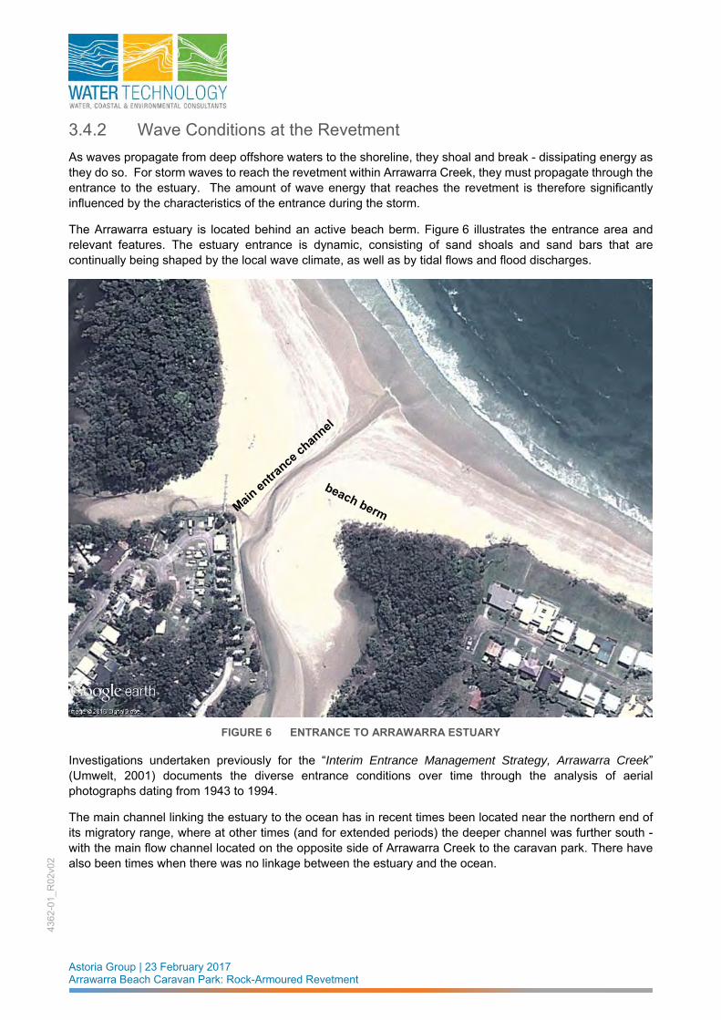
As waves propagate from deep offshore waters to the shoreline, they shoal and break - dissipating energy as they do so. For storm waves to reach the revetment within Arrawarra Creek, they must propagate through the entrance to the estuary. The amount of wave energy that reaches the revetment is therefore significantly influenced by the characteristics of the entrance during the storm.
The Arrawarra estuary is located behind an active beach berm. Figure 6 illustrates the entrance area and relevant features. The estuary entrance is dynamic, consisting of sand shoals and sand bars that are continually being shaped by the local wave climate, as well as by tidal flows and flood discharges.
FIGURE 6 ENTRANCE TO ARRAWARRA ESTUARY
Investigations undertaken previously for the “Interim Entrance Management Strategy, Arrawarra Creek” (Umwelt, 2001) documents the diverse entrance conditions over time through the analysis of aerial photographs dating from 1943 to 1994.
The main channel linking the estuary to the ocean has in recent times been located near the northern end of its migratory range, where at other times (and for extended periods) the deeper channel was further south - with the main flow channel located on the opposite side of Arrawarra Creek to the caravan park. There have also been times when there was no linkage between the estuary and the ocean.

Astoria Group | 23 February 2017 Arrawarra Beach Caravan Park: Rock-Armoured Revetment
4362
-01_
R02
v02
The crest levels of the beach berm separating the estuary from the ocean (as well as the bed level of the entrance channel that cuts through the berm) at various times were determined by a photogrammetric analysis in 1995 by the NSW Department of Land and Water Conservation (and are reported in Umwelt, 2003).
The results are summarised in Table 5. From which it can be seen that the average bed level of the channel captured in the photographic analysis was +0.8m AHD, with the lowest level being +0.4m AHD.
TABLE 5 HISTORICAL ENTRANCE CHANNEL AND BEACH BERM LEVELS
Year Crest Level of the Beach
Berm (m AHD) Entrance Channel Bed
Level (m AHD)
1956 +2.6 +0.5
1964 +2.4 -
1974 +2.4 +0.9
1981 +1.8 +1.0
1983 +1.5 +0.4
1988 +1.5 +1.0
1993 +2.2 +1.6
Averages +2.1 +0.8
However, during the peak of a major storm event, the entrance area experiences significant movement of sand as a consequence of large waves and the flow of waters between the estuary and ocean. The combination of elevated ocean water levels, large waves and the probable concurrent discharge of flood waters will result in a deeper and wider entrance area than what might occur naturally under more ambient conditions.
Therefore, in order to account for such a scenario when considering the penetration of storm waves through the entrance, a bed level of RL+0.2m AHD has been adopted. This has also been assumed to apply over an approximate foreshore width of 130 metres. This determination was made by considering the cross sectional profile of the entrance area captured in an April 2003 survey (Newnham Karl Weir, 2003) which was also used for a previous flood study for the Arrawarra estuary (Umwelt, 2003). That cross section has been reproduced as Figure 7.
FIGURE 7 ASSUMED ENTRANCE CROSS SECTION DURING DESIGN EVENT
ASSUMED SCOURED PROFILE AT ENTRANCE
RL +0.2 m AHD

Astoria Group | 23 February 2017 Arrawarra Beach Caravan Park: Rock-Armoured Revetment
4362
-01_
R02
v02
The assumed cross section for the purposes of determining wave penetration through the entrance during the design storm event is shown in red on that figure. The selected bed level of RL +0.2m AHD is the average depth of the two channels that cut through the entrance shoals at the time of the survey.
The wave climate at the revetment within the Arrawarra Estuary during severe storms is depth-limited. It is primarily the water depth within the entrance area that determines the amount of wave energy that reaches the structure.
Calculations of wave breaking phenomena on the seabed approaches to the estuary entrance and through the scoured entrance itself have been undertaken using the techniques defined in Goda (2000). The calculations consider the storm tide level, associated offshore wave characteristics (of height and period) and seabed approach slope to determine the change in wave height distribution within the surf zone as a consequence of wave breaking within a random sea state.
As discussed in Section 3.2, two potential scenarios for a 100 year ARI storm event are to be investigated, so that the one having the most adverse effect on structural performance of the revetment can be adopted. The two scenarios being:
Scenario 1 : the 100 year ARI storm tide level occurring simultaneously with the 50 year ARI wave characteristics; or
Scenario 2 : the 50 year ARI storm tide level occurring simultaneously with the 100 year ARI wave characteristics.
Consequently, the surf zone algorithms (Goda, 2000) have been applied to determine the effect of wave breaking through the assumed entrance cross sectional profile for each of these two scenarios. A number of possible offshore wave periods in the range of 7 – 14 seconds have been considered since wave breaking is also dependent upon wave period.
In undertaking the calculations of wave transformation from deep offshore waters into the lower reaches of the estuary, no account is taken of wave energy losses due to seabed friction or diffraction / refraction on seabed approaches and/or through the entrance. Whilst such complex processes will result in some dissipation of wave height, these potential wave attenuating processes have not been considered.
The results of the investigations of wave breaking at the estuary entrance under design storm conditions are summarised overleaf in Table 6 - which shows the significant wave height (Hs) of the wave height distribution in the surf zone. Also included in that table is the other important design parameter of storm tide level.
It is perhaps pertinent to note that the storm tide level adopted at the revetment is that determined on local ocean foreshores. It therefore includes the effects of wave setup. Depending on flood flow characteristics occurring concurrently in the estuary, it is possible that the wave setup component of the peak storm tide could dissipate very quickly within the estuary itself. Nevertheless, it is assumed that the entire height of ocean-side wave setup applies throughout the lower reaches of Arrawarra Estuary.

Astoria Group | 23 February 2017 Arrawarra Beach Caravan Park: Rock-Armoured Revetment
4362
-01_
R02
v02
TABLE 6 DESIGN SIGNIFICANT WAVE HEIGHTS AND STORM TIDE LEVELS
Wave Period Scenario 1 Scenario 2
1-hour duration 6-hour duration 1-hour duration 6-hour duration
7 secs 2.0m 2.0m 2.0m 1.9m
8 secs 2.1m 2.0m 2.0m 2.0m
9 secs 2.1m 2.1m 2.1m 2.0m
10 secs 2.2m 2.1m 2.1m 2.1m
11 secs 2.2m 2.2m 2.2m 2.1m
12 secs 2.3m 2.2m 2.3m 2.2m
13 secs 2.3m 2.3m 2.3m 2.2m
14 secs 2.4m 2.4m 2.4m 2.3m
Storm tide level RL +3.04m AHD RL +2.91m AHD
3.5 Accommodation of Future Climate Change Influences The implications of potential change to the climatology of eastern Australia as well as possible sea level rise need to be considered and incorporated into structural assessments and designs of foreshore protection works where appropriate. When considering the implications of future climate change in the design of the revetment, reference has been made to the publication “Projected Changes in Climatological Forcing for Coastal Erosion in NSW” (McInnes, et al., 2007a).
In reality, any increase in offshore wave characteristics alone are unlikely to result in significant practical changes to the required size of armouring of foreshores. Of greater concern is the potential threat posed by a rise in sea level.
Sea level rise as a consequence of future climate change could result in potentially greater depths of water over the entrance shoals of Arrawarra Creek - allowing greater wave energy to penetrate into the estuary and impinge on the rock-armoured revetment. The higher ocean level also has the potential for inducing greater wave overtopping on a revetment built to accommodate present-day wave and ocean water conditions. Given that the crest level of any revetment along the estuarine foreshore is likely to be vulnerable to wave overtopping during severe storms, the implications of future sea level rise need to be considered in the design of any proposed revetment works.
This is not to suggest that new revetment works need to be constructed to accommodate all aspects of future climate change now. It would however be prudent to design the armour layer to be able to accommodate the expected increased wave energy (as a consequence of sea level rise and changed storm climatology).
The predicted increase in wave overtopping could be included as subsequent upgrading works if/when it manifests itself. For instance, the design could be undertaken to structurally accommodate present-day overtopping rates by incorporating crest armour and/or raising the crest level, but be cognisant of the possibility that future works (such as raising the crest level even higher) may be required in the later years of the revetment’s design life.
Astoria Group | 23 February 2017 Arrawarra Beach Caravan Park: Rock-Armoured Revetment
4362
-01_
R02
v02
In this way the design and construction would not compromise the options of dealing with increased overtopping due to climate change at a later date, yet provides a structure that is more closely matched with existing bank alignments and heights.
The fundamental design philosophy adopted for addressing potential effects of future climate change in the design of the revetment is as follows:
sea level rise to the year 2100 – consider implications of a sea level rise of 0.8metres above present-day mean sea levels.
wave climate to the year 2100 – consider implications of a 10% increase in offshore wave heights
to address issues relating to potential erosion of the armour layer – select rock size in accordance with present-day climate scenario, but tailor the design such that upgrading works can be readily undertaken should future climate change and sea level rise require modifications.
to address issues relating to potential undermining of the revetment - determine foundation requirements that accommodate the expected increases in wave energy and sea level as a consequence of future climate change.
to address issues relating to the potential overtopping of the revetment - determine crest armouring requirements that will accommodate the present-day climate scenario, but be mindful when preparing the revetment design that future climate change and sea level rise may require modifications and/or additional works in future.
3.5.1 Future Storm Tide Levels
When considering the 100 year ARI storm tide level for future climate scenario in the year 2100, the design approach has been to simply add the 0.8m sea level rise to the present-day storm tide levels.
It is acknowledged that this is a simplistic approach, since there are other climatological factors that influence the storm surge component of storm tide. However, modelling of future climate change scenarios (McInnes, et al., 2007a and 2007b) predict changes to present-day storm surge levels ranging from a decrease of 3% to an increase of 4% on present-day surge heights - depending upon which climate model simulation is used. Consequently, for the purposes of designing the revetment, such influences are deemed to be minimal.
In summary, when considering the 100 year ARI storm tide level in the year 2100, 0.8 metres is added to the present-day levels for each of Scenario 1 and 2. This results in a 50 year ARI storm tide level of +3.71m AHD and a 100 year ARI level of +3.84m AHD for 2100.
3.5.2 Future Wave Conditions at the Revetment
As stated previously, ocean waves propagating into the estuary are depth-limited. The amount of wave energy penetrating through the entrance is determined primarily by the depth of water over the entrance shoals. A gradual rise in sea level will be matched by gradual changes in the coastal processes that shape the entrance.
No attempt has been made during the design of the revetment to determine just what future changes might occur at the entrance. Instead the simplistic approach has been to assume that the beach berm and scoured channel levels that are predicted for present-day climate scenario (refer Figure 7) will be the same in the future under climate change influences.
In which case there will be a 0.8 metre increase in depth over entrance bed levels as a consequence of future climate change to the year 2100. Therefore, when determining implications to future wave heights at the revetment, the surf zone algorithms (Goda, 2000) have been applied to determine the effect of wave breaking through the entrance cross sectional profile having the same bed level of RL +0.2m AHD as used for present-day conditions.
Astoria Group | 23 February 2017 Arrawarra Beach Caravan Park: Rock-Armoured Revetment
4362
-01_
R02
v02
In other words, when applying the Goda algorithms to determine wave conditions at the revetment, the prevailing depths over the entrance are considered as being 0.8 metres deeper than for present-day scenario, and offshore wave heights are 10% higher. When these potential changes are applied to the Goda algorithms, they result in wave heights that are between 20% and 25% higher than those listed in Table 6 for present-day climate scenario.
The implications to the design of the revetment are discussed in the following Section 4 of this report.
.

Astoria Group | 23 February 2017 Arrawarra Beach Caravan Park: Rock-Armoured Revetment
4362
-01_
R02
v02
4 STRUCTURAL DESIGN OF THE REVETMENT
4.1 Design Constraints When undertaking the structural design of the revetment there are a number of constraints that need to be considered and accommodated, namely:
1. The structure is to be located entirely within the caravan park site. This means that it must not intrude into the estuary beyond the foreshore property boundary. This is defined on survey drawings and generally coincides with a previously surveyed line of Mean High Water Mark (MHWM).
2. Construction activity should also be confined to within the property itself. This will guide the selection for the position of the bottom of the armoured slope, and the measures taken to mitigate scour.
3. The armoured slope should minimise disturbance of the existing embankments of Arrawarra and Yarrawarra Creeks – with the front slope and crest level of the structure coinciding with the existing slope and level of the creek banks as much as possible.
These considerations are incorporated into the design elements which address the three fundamental damage / failure mechanisms for the rock-armoured revetment (refer to discussions in Section 2), these being:
erosion of the armour layer
undermining
wave overtopping
4.2 Mitigating Erosion of the Armour Layer Various methods for calculating the size of rock armour under wave attack have been proposed by coastal engineers in the past few decades. The decision as to which mathematical technique is the most appropriate has been the subject of much deliberation, however most practitioners are now generally agreed that the formulae originally developed by van der Meer (1988) are the most appropriate. They are based upon an extensive series of physical model tests, which included a wide range of incident wave conditions, nearshore bathymetry, core / underlayer permeabilities, and rock characteristics. The application of these algorithms to the design of rock armoured structures is well documented in CIRIA et.al. (2007).
Consequently, the design techniques attributed to van der Meer have been applied in the development of the engineering design for the revetment in the Arrawarra estuary. In doing so, the extent of damage that is deemed to be acceptable under the 100 year ARI design criteria has been selected as 5%. This is in keeping with widely accepted practice when designing rock armoured works.
The slope of the armour layer has been selected as 1 vertical to 1.5 horizontal. Previous experience shows that a flatter gradient is more difficult to build without specialised long-reach excavators. Flatter slopes require a greater volume of rock product, and also have significantly greater impact on the visual amenity of the foreshore. Along the banks of Arrawarra and Yarrawarra Creeks, a flatter revetment slope is also not desirable because it would significantly alter the form of the existing embankments and permanently disturb estuarine vegetation.

Astoria Group | 23 February 2017 Arrawarra Beach Caravan Park: Rock-Armoured Revetment
4362
-01_
R02
v02
4.2.1 Present-day climate The preceding Table 6 presented the design parameters for several scenarios that could constitute the 100 year ARI storm event. Each scenario has been used to calculate the necessary armour rock size using the design techniques based on van der Meer’s algorithms for a conventional two-layered armouring arrangement. The outcomes are presented in Table 7 as the median mass (M50) armour rock size required for each 100 year ARI scenario.
TABLE 7 ROCK ARMOUR REQUIREMENTS FOR 100 YEAR ARI STORM EVENT
Wave Period Scenario 1 Scenario 2
1-hour duration 6-hour duration 1-hour duration 6-hour duration
7 secs 613kg 996kg 575kg 935kg
8 secs 705kg 1098kg 643kg 1012kg
9 secs 612kg 949kg 556kg 878kg
10 secs 528kg 821kg 488kg 760kg
11 secs 470kg 731kg 435kg 665kg
12 secs 422kg 649kg 391kg 601kg
13 secs 377kg 581kg 355kg 539kg
14 secs 345kg 532kg 324kg 493kg
FIGURE 8 REQUIRED DESIGN FOR MITIGATING FAILURE BY EROSION OF THE ARMOUR LAYER
Primary Armour 2 layers of 1 tonne rock (range 0.35 - 3 tonne)
Underlayer rock 2 layers of 100 kg rock (range 30 - 350 kg)
Geotextile on bank slope
1330mm ( i )
620mm ( i )
1.5
1

Astoria Group | 23 February 2017 Arrawarra Beach Caravan Park: Rock-Armoured Revetment
4362
-01_
R02
v02
As a consequence, the characteristics illustrated in Figure 8 have been applied to mitigate any potential damage / failure by erosion of the rock armour. These being:
Primary armour: Two layers of rock, 50% by number greater than 1 tonne (allowable range in size being 0.35 tonne to 3 tonne).
Minimum layer thickness of primary armour: 1330mm.
Underlayer rock: Two layers, average size 100kg (allowable range 30kg to 350kg).
Minimum underlayer thickness: 620mm.
Minimum rock density: 2,650 kg/m3.
Revetment slope: 1 vertical to 1.5 horizontal
Suitability of all rock for application in marine works confirmed by petrographic analyses.
Geotextile on underlying bank slope: Elcomax 600R or an approved equivalent
The physical extent of this armouring arrangement on the foreshore of the site is shown on Figure 9.
FIGURE 9 PHYSICAL EXTENT OF ARMOURING ARRANGEMENTS
YARRAWARRA CREEK
EXTENT OF ARMOURED FORESHORE
Astoria Group | 23 February 2017 Arrawarra Beach Caravan Park: Rock-Armoured Revetment
4362
-01_
R02
v02
4.2.2 Accommodating future climate change
As stated earlier in Section 3.5, future climate change is likely to see increased depths of water over the estuary entrance and potentially increased offshore wave heights associated with the 100 year ARI storm.
When the increased water depth of 0.8 metres at the toe of the armoured slope (for future sea level rise) and the predicted 25% increase in wave heights at the structure are applied to the design techniques based on van der Meer’s algorithms - it is found that an additional (i.e. third) layer of 1 tonne rocks is required so as to accommodate the 100 year ARI storm event in the year 2100.
Rather than place this layer during initial construction, allowance is instead made for placement at a future time. When setting out the position and alignment of the revetment cross section, a one metre setback from the property boundary has been adopted to facilitate the future placement of the third layer of primary armour.
4.3 Mitigating Damage by Undermining As discussed in Section 2.3.1, there are basically two ways in which undermining failure can be avoided, namely:
a. by placing non-erodible material as a scour blanket on the creek bed in front of the revetment (ie. toe armour); or
b. by founding the revetment’s armour layer at a depth below the expected level of scour in the creek.
If the option of placing a scour blanket on the creek bed in front of the armoured slope was to be implemented, it must be located within the property boundary so as to accommodate that particular requirement. This means the revetment slope itself would need to be located further landward than the existing creek banks – necessitating excavation and relocation of the creek banks. Such excavation and landward relocation would be particularly significant along the high vegetated banks of Yarrawarra Creek.
Founding the revetment slope deeper than the expected scour level of the creek bed is therefore the preferred option. It enables the entire structure and all construction work (including excavation/backfilling for the deeper toe) to be located within the property boundary. More importantly, it also minimises any relocation or realignment of the existing creek banks, with associated benefits to retention of adjacent estuarine vegetation.
4.3.1 Present-day climate
The methodology for selection of the founding level for the armoured revetment has been:
At 10 metre intervals along the alignment of the revetment, identify the corresponding thalweg5 level in the creek channel. This process references a survey (including cross sections across Arrawarra and Yarrawarra Creeks) undertaken in 2015 (Newnham Karl Weir, 2015). In many cases the thalweg was located on the opposite side of the creek to the proposed revetment.
Determine the level that is one D50 rock size below that thalweg level. This corresponds to a depth of 0.72 metres for the M50 armour rock size of 1 tonne.
Rather than have a variable toe level along the length of the revetment, for construction purposes rationalise the selected toe level along sections of the structure.
5 The thalweg is an imaginary line drawn to join the lowest points along the length of a stream bed or watercourse in its downward slope. It therefore defines the longitudinal profile of the deepest part of the creek bed.

Astoria Group | 23 February 2017 Arrawarra Beach Caravan Park: Rock-Armoured Revetment
4362
-01_
R02
v02
TABLE 8 FOUNDING LEVEL OF ROCK-ARMOURED SLOPE
Chainage Thalwag Level
to AHD 1 x D50 below to
AHD Adopted level of toe
to AHD
0 0.54 -0.18
RL -0.5m AHD 10 0.57 -0.15
20 0.43 -0.29
30 0.19 -0.53
40 -0.18 -0.90
RL -1.0m AHD
50 -0.08 -0.8
60 -0.15 -0.87
70 -0.2 -0.92
80 -0.2 -0.92
90 -0.13 -0.85
100 -0.18 -0.90
110 -0.13 -0.85
120 -0.19 -0.91
130 -0.06 -0.78
140 -0.05 -0.77
150 -0.08 -0.80
160 -0.14 -0.86
170 -0.09 -0.81
180 -0.19 -0.91
190 -0.4 -1.12
200 -0.09 -0.81
210 0.16 -0.56
220 0.15 -0.57
230 0.14 -0.58
240 0.3 -0.42
250 0.29 -0.43
260 0.37 -0.35
270 0.39 -0.33
RL -0.5m AHD
280 0.34 -0.38
290 0.41 -0.31
300 0.42 -0.30
310 0.32 -0.40
320 0.17 -0.51
330 0.16 -0.52
340 0.11 -0.50
350 0.13 -0.52
360 0.14 -0.53
370 0.19 -0.52
380 0.14 -0.52
390 0.17 -0.51
400 0.25 -0.47
410 0.29 -0.43
420 0.24 -0.48
430 0.23 -0.49
440 0.17 -0.50
450 0.19 -0.51

Astoria Group | 23 February 2017 Arrawarra Beach Caravan Park: Rock-Armoured Revetment
4362
-01_
R02
v02
The results are summarised in Table 8. From which it can be seen that a buried toe level has been selected at RL -0.5m AHD along the shallower sections of Yarrawarra and Arrawarra Creeks, but is at RL -1.0m AHD for the deeper sections – mostly along the revetment where it is opposite the estuary entrance. It is pertinent to note that the level of ISLW (refer Table 2) is approximately RL -1.0m AHD. The extent of the various toe levels is shown conceptually in Figure 10, whereas the drawings in Appendix A show the precise location.
FIGURE 10 APPROXIMATE LOCATIONS OF TOE LEVELS
In acknowledgement of the complexity of the processes associated with such scour (and potential inherent uncertainties in predicting their outcomes), a further precaution has been included as a design detail for the toe of the rock armouring. A row of large rocks (minimum size of 3 tonnes, with corresponding D50 physical size of 1 metre) is to be placed along the buried toe of the revetment to form a buttress for the armoured slope above. The concept is shown in the sketch of Figure 11.
In the event of scour being greater than expected at a particular location on the revetment, it will be these large rocks that will first be “undermined”. These large rocks then slump into the lower scoured bed, thereby armouring the edge of the scour hole that is immediately in front of the revetment. Whilst this can lead to some settlement or shifting of rocks within the matrix of the primary armour above, the structure will remain intact since the buttress rock is still able to serve its purpose.
TOE AT RL – 0.5m AHD
TOE AT RL-1.0m AHD

Astoria Group | 23 February 2017 Arrawarra Beach Caravan Park: Rock-Armoured Revetment
4362
-01_
R02
v02
It is important to appreciate that this toe detail is an added precaution only - and that the founding level of the revetment toe is selected so as to mitigate the threat of undermining.
FIGURE 11 REQUIRED DESIGN FOR MITIGATING FAILURE BY UNDERMINING
4.3.2 Accommodating future climate change
Gradual changes to future climate will be matched by gradual morphological changes to the natural processes that shape the lower reaches of the Arrawarra estuary. No attempt has been made during the design of the revetment to determine just what future changes might occur within the estuary. Instead the simplistic approach has been to assume that the channel bed levels that have been surveyed for present-day climate scenario will be the same in future under climate change influences.
This then means that the toe levels of the revetment determined for present-day conditions are adequate for future climate conditions in the year 2100.
4.4 Mitigating Damage by Overtopping
4.4.1 Present-day climate
The fundamental approach adopted for the design of the revetment along the estuarine banks of both Yarrawarra and Arrawarra Creeks has been to maintain the existing alignment and levels of the banks as much as possible.
Typically, the 100 year ARI storm tide level in the ocean and in the estuary will be either at or above the bank levels of the creek system along the frontage of the Arrawarra Beach Caravan Park. Under such a scenario there would be significant green-water overtopping of the creek banks, which means that any new revetment that follows the alignment and levels of the creek banks will also be overtopped.
The strategies adopted for mitigating damage by overtopping take account of an approximately 20 metre wide E2 Zone buffer to essential infrastructure immediately behind the revetment slope.
Buttress rock at toe. Minimum size 3
tonnes No higher than 0.72m below channel
thalweg level

Astoria Group | 23 February 2017 Arrawarra Beach Caravan Park: Rock-Armoured Revetment
4362
-01_
R02
v02
The design techniques outlined in the “Wave Overtopping of Sea Defences and Related Structures: Assessment Manual” (EurOtop, 2007) have been applied to the design of the revetment crest for conditions associated with the 100 year ARI Design Event. Calculations of overtopping rates during such an extreme event show that discharges will scour any unprotected erodible material in the area immediately behind the revetment.
Therefore, the design options considered for treatment of the crest along the alignment of the revetment have been:
Option 1:
Given that there is a 20 metre wide E2 Zone buffer located between the revetment and essential infrastructure, elect to accept that there will be scouring of this buffer by overtopping waves during the 100 year ARI event. But place a row of large abutment rocks at the rear of the crest to mitigate erosion of the revetment crest itself. Post-storm repairs would then be concerned with reinstating scour-damaged landscaping within the E2 Zone buffer immediately behind the revetment - with minimal or no damage repairs to the crest of the revetment.
Option 2:
Provide a scour blanket of armour rocks behind the crest to mitigate any scour of the E2 Zone. This scour blanket would be covered with topsoil and vegetated as appropriate. However such landscaping works would be damaged during the 100 year ARI design event, but the revetment and levels across the 20 metre wide E2 Zone would remain primarily intact with minimal scour.
Both options have been adopted, with each shown on Figure 12.
FIGURE 12 REQUIRED DESIGN FOR MITIGATING FAILURE BY WAVE OVERTOPPING

Astoria Group | 23 February 2017 Arrawarra Beach Caravan Park: Rock-Armoured Revetment
4362
-01_
R02
v02
Option 1 (shown as Type Cross Section 1 in Figure 12) is applied where the existing creek bank is at or above RL +3.0m AHD, which is typically along the higher banks of Yarrawarra Creek. Option 2 (shown as Type Cross Section 2 in Figure 12) is applied along the bank of Arrawarra Creek where existing bank levels are lower at approximately RL +2.5m AHD.
4.4.2 Accommodating future climate change
The revetment design has been tailored so that additional crest armour can be readily added to the revetment cross sections to accommodate overtopping waves during the 100 year ARI storm tide event in the year 2100.
It is perhaps pertinent to note that the expected increased overtopping of the revetment during storms in future years will not be a sudden manifestation, but will be a gradual process. It would invariably result in an increasing requirement to repair the landscaping immediately behind the armoured slope, as well as the crest itself.

Astoria Group | 23 February 2017 Arrawarra Beach Caravan Park: Rock-Armoured Revetment
4362
-01_
R02
v02
5 REFERENCES
BMT WBM, 2011. Coffs Harbour Coastal Processes and Hazards Definition Study. Volume 1: Final Report. Prepared for Coffs Harbour City Council. Revision 2, dated 15 February 2011. Document R.N1440.002.02.CoastalHazards_Final.doc.
CIRIA/CUR/CETMEF (2007). The Rock Manual. The Use of Rock in Hydraulic Engineering (2nd Edition). C683. Published by CIRIA, London. ISBN: 978-0-86017-683-1. June 2007
EurOtop. 2007. Wave Overtopping of Sea Defences and Related Structures: Assessment Manual. Developed for EA/Defra, Rijkswaterstaat in the Netherlands and the German Coastal Engineering Research Council (KFKI). August 2007. Also published online URL http://www.overtopping-manual.com/calculation_tool.html.
Goda, Y., 2000. Random Seas and Design of Maritime Structure. Published by World Scientific Publishing Co. Pte. Ltd. Advanced Series on Ocean Engineering - Volume 15. ISBN 981-02-3256-X.
Macadam, I., McInnes, K. and J. O'Grady, (2007 a). Climate Change Projections for the Wooli Wooli Estuary and Batemans Bay, prepared by CSIRO for the Department of Environment and Climate Change [DECC].
McInnes, K. L., Abbs, D.J., O'Farrell, S.P., Macadam, I., O'Grady, J. and R. Ranasinghe, (2007 b). Projected Changes in Climatalogical Forcing for Coastal Erosion in NSW, prepared by CSIRO for the Department of Environment and Climate Change [DECC].
Manly Hydraulics Laboratory. 2012. OEH NSW Tidal Planes analysis. 1920-2010 Harmonic Analysis. Prepared for the Office of environment and Heritage. Report No. MHL2053. PW Report No. 11009. ISBN 9780 7347 4435 4. Published 03 October 2012.
Newnham Karl Weir & Partners Pty. Ltd. (2003). Cross Sections Yarrawarra Creek. Arrawarra Caravan Park, Arrawarra, New South Wales. Drawing / Plan reference 3251XS – Sheets 1 to 5. April 2003.
Newnham Karl Weir & Partners Pty. Ltd. (2015). Arrawarra Beach Caravan Park.. Survey Reference 9826. Drawing set of 7 sheets. Dated 14 April 2015.
Umwelt (Australia) Pty Ltd. (2001). Interim Entrance Management Strategy, Arrawarra Creek. Prepared for the NSW Department of Land and Water Conservation. Report No. 1409/R01.V2. June 2001.
Umwelt (Australia) Pty Ltd. (2003). 1in 100 Year Flood Study, Lot 1 DP 789002, Lot 1 DP 26125 & Lot 12 DP 835612, Arrawarra Beach Caravan Park, Arrawarra. Prepared for Astoria Developments Pty Ltd. Report No. 1698/R03_V1. September 2003.
Van der Meer, J.W., 1988. Rock slopes and gravel beaches under wave attack. Published as PhD dissertation; also Delft Hydraulics Communication No. 396.

Astoria Group | 23 February 2017 Arrawarra Beach Caravan Park: Rock-Armoured Revetment
4362
-01_
R02
v02
APPENDIX A REVETMENT DESIGN DRAWINGS PREPARED BY COASTAL ENGINEERING SOLUTIONS PTY LTD


Click t
o buy NOW!
PDF-XChange
ww
w.tracker-software.c
om Click t
o buy NOW!
PDF-XChange
ww
w.tracker-software
.com
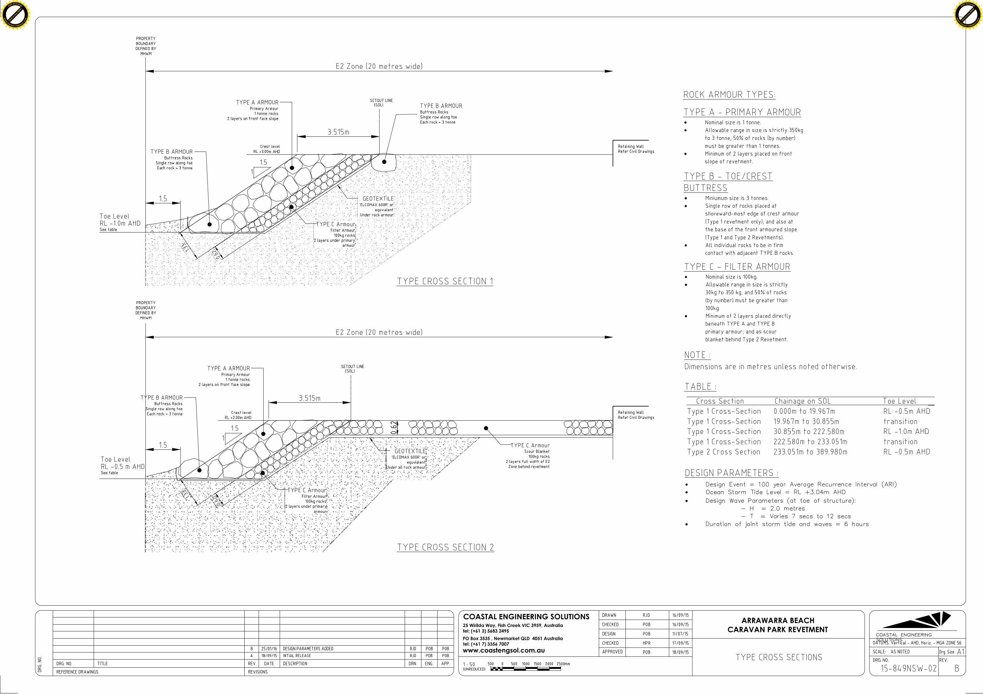
Click t
o buy NOW!
PDF-XChange
ww
w.tracker-software.c
om Click t
o buy NOW!
PDF-XChange
ww
w.tracker-software
.com


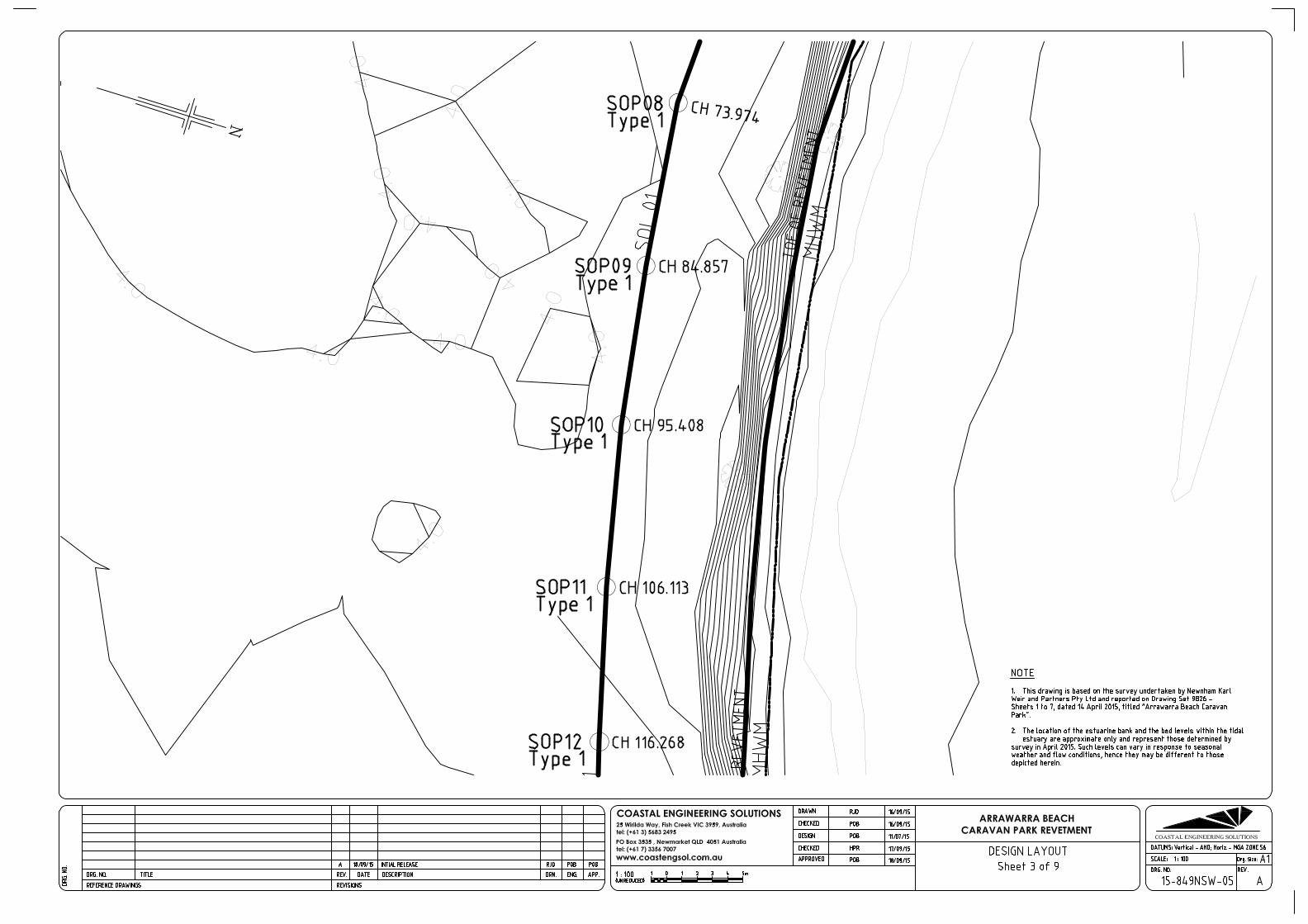


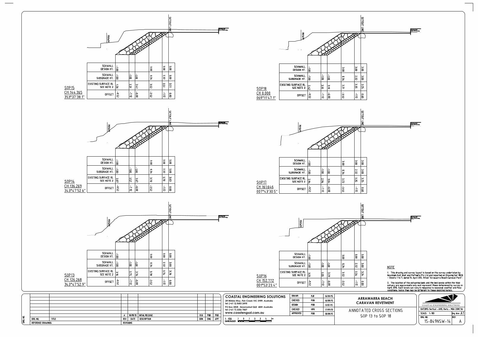
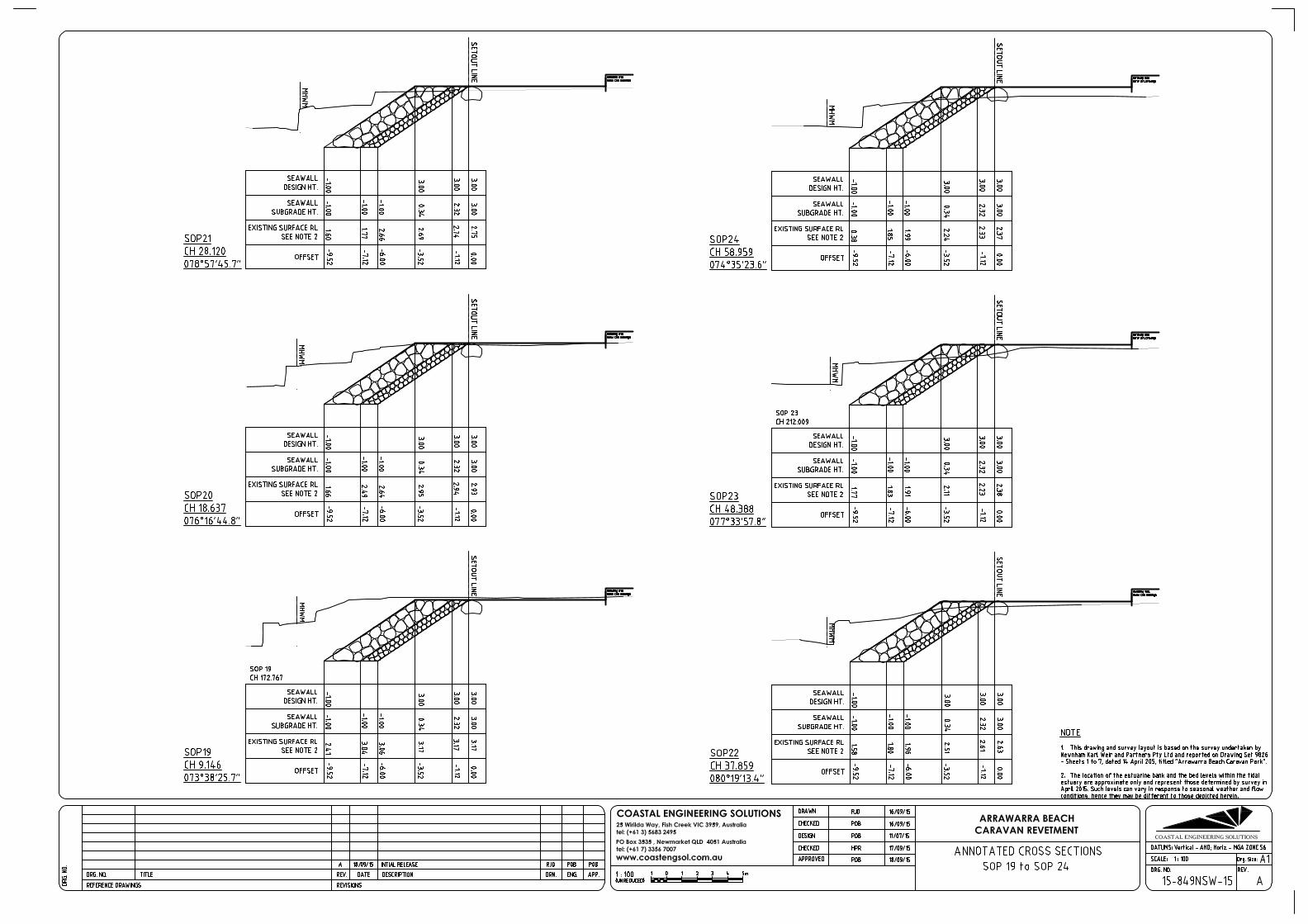


Astoria Group | 23 February 2017 Arrawarra Beach Caravan Park: Rock-Armoured Revetment
4362
-01_
R02
v02
The following summary table has been prepared by Keiley Hunter Town Planning as Appendix P of the DRAFT Statement of Environmental Effects for the project (February 2017).
APPENDIX B SUMMARISED OUTCOMES OF DISCUSSIONS WITH THE NSW COASTAL PANEL REGARDING THE NEW REVETMENT
STATEMENT OF ENVIRONMENTAL EFECTS
FEBRUARY 2017
COASTAL PROTECTION WORKS
46 Arrawarra Beach Road, Arrawarra 1
P
DA CP16-001

STATEMENT OF ENVIRONMENTAL EFECTS
FEBRUARY 2017
COASTAL PROTECTION WORKS
46 Arrawarra Beach Road, Arrawarra 2
Table P1 DA CP16-001 Timeline
DATE EVENT
11 February 2016 DA submitted to NSW Coastal Panel
15 February 2016 DA received by the NSW Coastal Panel (DA16-001)
10 March 2016 Request for additional information
22 March 2016 Response to request for additional information
15 April 2016 Site visit with NSW Coastal Panel members:
Mr Angus Gordon – Chair
Professor Andrew Short - nominee of Local Government
NSW
Ms Jane Lofthouse - nominee of Local Government NSW
Emeritus Professor Bruce Thom - nominee of Local
Government NSW
Dr Carolyn Davies - Office of Environment and Heritage and
Deputy Chair
Mr Stephen Wills - Department of Primary Industries (Lands)
Ms Jane Gibbs - Coastal Panel Secretariat Support / Senior
Manager Environmental Program Services
Phil Watson - Coastal Panel Secretariat Support / Principal
Coastal Specialist
Dr Marc Daley - Coastal Panel Secretariat Support / Senior
Coast & Estuaries Officer
4 April to 3 May 2016 Public exhibition period (Integrated Development)
19 April 2016 NSW Coastal Panel request for additional information
26 April 2016 NSW Office of Water (DPI) General Terms of Approval granted.
1 July 2016 Additional information submitted electronically to NSW Coastal
Panel
12 August 2016 SEPP 26 Concurrence, additional aboriginal cultural heritage and
ecological addendum report provided to the NSW Coastal Panel
24 August 2016 Seawall ‘DWG” file provided to NSW Coastal Panel
22 September 2016 Umwelt Flood Study 2003 provided to NSW Coastal Panel
22 September 2016 Receive notification of NSW Coastal Panel determination meeting
set down for 12 October 2016.
10 October 2016 Royal HaskoningDHV and City Plan Services assessment reports
uploaded to the NSW Coastal Panel website.
10 October 2016 Letter to NSW Coastal Panel - Request determination be deferred.
12 October 2016 Letter to NSW Coastal Panel - Request determination be deferred
and provide planning justification for proposed revetment –
Landscape Plan and Ecological Assessment attached.

STATEMENT OF ENVIRONMENTAL EFECTS
FEBRUARY 2017
COASTAL PROTECTION WORKS
46 Arrawarra Beach Road, Arrawarra 3
DATE EVENT
20 October 2016 Royal HaskoningDHV consultant conducts site visit to verify desktop
assessment.
21 October 2016 NSW Coastal Panel advice that determination of the DA is set down
for 2 November 2016 and that any additional information must be
provided by close of business on 28 October 2016.
28 October 2016 Submit Supplementary SoEE to NSW Coastal Panel.
2 November 2016 NSW Coastal Panel defer determination of the DA.
1 December 2016 NSW Coastal Panel’s planning consultant, City Plan Services and
engineering consultant, Royal Haskoning DHV provide amended
assessment reports.
5 December 2016 Submit additional information in response to the panel consultant’s
assessment reports and recommendations.
Appendix P.
6 December 2016 NSW Coastal Panel determine DA CP16-001.

STATEMENT OF ENVIRONMENTAL EFECTS
FEBRUARY 2017
COASTAL PROTECTION WORKS
46 Arrawarra Beach Road, Arrawarra 4
Table P2 summarises matters raised and responses to the panel’s requests for further information. Please note that in the latter stages of the assessment process, the Panel’s independent engineering consultant, Mr Paul Blumberg RHDHV, “closed out” most of the revetment design issues following the submission of explanatory information from the project engineers.
Table P2 Requests for Further Information – DA CP 16-001
NSW Coastal Panel Request Response
March 2016
How the relevant design wave and water level conditions advised have been determined for application at the proposed site;
The methodology applied to the design of the
revetment by Coastal Engineering Solutions
(now Water Technologies) has been to adopt
the Design Event having the 100 year ARI
storm tide and associated wave
characteristics defined by the comprehensive
modelling undertaken for the Coffs Harbour
Coastal Processes and Hazards Definition
Study (BMT WBM, 2011).
What design approach (or stability assessment) has been applied in order to propose the configuration of structure (slope, toe level, crest level, rock sizes, etc) to withstand the design coastal processes and hydraulic loadings envisaged;
The design techniques attributed to van der
Meer in conjunction with the approach of
placing armour to accommodate future
climate influences have been applied by
Coastal Engineering Solutions for the
engineering design of the rock‐armoured
revetment.
The extent of damage that is deemed to be
acceptable under the 100 year ARI design
criteria was selected as 5%.
Whether the scour levels at the toe of the proposed structure indicated are sufficient in this location. With a revetment structure in place to prevent channel or bank migration under flood outflows, there might be the potential for high velocities and associated sand losses from the near vicinity of the structure exceeding those considered relevant for normal beach scour levels on the open coast;
A row of Type B Armour (minimum 3 tonne
rocks) is to be placed along the toe of the
revetment to form a buttress for the armoured
slope above. In the unexpected event of
scour being greater than expected at a
particular location on the revetment, it will be
these large rocks that will first be
“undermined”. These large rocks then drop
into the lower scoured bed, thereby
armouring the edge of the scour hole that is
immediately in front of the revetment. Whilst
this can lead to some settlement or shifting of
rocks within the matrix of the primary armour
above, the structure will remain intact since
the buttress rock is still able to serve its
purpose.
What consideration (if any) has been given to the likelihood of wave overtopping of the structure (given the crest level advised is particularly low in parts). If there is overtopping of the structure, how will this be managed?
The design techniques outlined in the “Wave Overtopping of Sea Defences and Related Structures: Assessment Manual” (EurOtop,
2007) have been applied by Coastal

STATEMENT OF ENVIRONMENTAL EFECTS
FEBRUARY 2017
COASTAL PROTECTION WORKS
46 Arrawarra Beach Road, Arrawarra 5
NSW Coastal Panel Request Response
March 2016
The crest levels advised might be sufficient to limit overtopping to acceptable levels but, there is no evidence this has been considered from the furnished information; and
Engineering Solutions for conditions associated
with the 100 year ARI Design Event.
What maintenance regime (if any) is contemplated for such a structure (given what’s proposed is a flexible rubble-mound structure) in order that it remain fit for purpose to meet desired level of protection following damage into the future. Further, how will it be adapted or maintained to accommodate projected sea level rise. Whilst sea level rise is acknowledged in the report there is no further information on how the structure has been designed to accommodate (or adapt to) such projections into the future.
The rock armour has been sized to
accommodate the expected effects of future
sea level rise, as well as changes to the
regional wave climate. The rock armouring is
more robust than it needs to be for present‐day climate conditions, and will prove to be
adequate during a more severe 100 year ARI
storm tide and wave event occurring at some
point in the future ‐when the predicted
climate change effects have manifested
themselves.
The revetment design is such as to limit
damage levels to 5%. In actual fact this may
not necessarily require any significant repair
works. The term “damage” nominated in such
a way in coastal engineering designs
accounts for the percentage of individual
rocks which move from their initially placed
position – which can be to a more stable
position within the rock armour matrix. Often
during severe storm events, the rock armour
slope consolidates – resulting in a tightening of
interlocking between individual rocks. So
future 5% “damage” can also represent an
improvement in structural stability at some
locations within the revetment.
NSW Coastal Panel Request Response
April 2016
Information concerning the impact of the wall on the geometry of the Creek. The impact assessment provided does not address any potential offsite impacts the wall itself may have. These impacts may arise from the readjustment of the creek and estuary entrance to the construction of the wall. The Panel notes the ecological significance of the land surrounding the proposed seawall.
Additional modelling was carried out by
Umwelt (Australia) Pty Ltd to determine flow
velocity within the creek environment and the
potential for offsite impacts. Umwelt prepared
a 2D finite element mesh roughness value
model to determine flow velocity under
existing landform versus with the proposed
revetment. The results are that there is
essentially no change in flow velocity
(Appendix E).

STATEMENT OF ENVIRONMENTAL EFECTS
FEBRUARY 2017
COASTAL PROTECTION WORKS
46 Arrawarra Beach Road, Arrawarra 6
NSW Coastal Panel Request Response
April 2016
Given the footprint of the proposed seawall, any mitigation measures proposed to minimise impacts on existing vegetation both on site and offsite, and proposed mitigation measures for any Aboriginal cultural heritage items identified on the site.
The footprint of the proposed seawall has not
altered.
Vegetation within and surrounding the site has
been comprehensively assessed by NatureCall
and Ecosure. In the most recent assessment,
Ecosure found that:
Littoral Rainforest The 7 part test found that it is not expected that the removal of the trees will have a negative impact on the surrounding EEC in the locality given the small number of trees being removed. A Species Impact Statement is not recommended. Coastal Saltmarsh Approximately 0.002 ha (20 m2) Coastal Saltmarsh will be removed by the proposal. It is considered that the Coastal Saltmarsh EECs within the Arrawarra estuary are unlikely to be significantly affected by the proposed action as the two small isolated patches do not form part of the community. A Species Impact Statement is not recommended. The primary beneficial mitigation measure for
impacts to existing vegetation will be
compensatory planting of native species within
the E2 zone.
Aboriginal Cultural Heritage Everick Heritage Consultants are of the opinion
that given the extent of existing disturbance within the development footprint, the proposed rock revetment is unlikely to result in further harm to Aboriginal Heritage. No Aboriginal Objects were identified within the area of Proposed Works. One known Aboriginal site (Arrawarra Headland Site #22-1-0392) was recorded to extend into the Project Area however is well within the proposed environmental buffer zone and has been previously disturbed. Mitigation measures are as listed on page 50 of
the Aboriginal Cultural Heritage Assessment.
.

STATEMENT OF ENVIRONMENTAL EFECTS
FEBRUARY 2017
COASTAL PROTECTION WORKS
46 Arrawarra Beach Road, Arrawarra 7
Royal HaskoningDHV reviewed DA CP16-001 on behalf of the panel. Table P3 summarises RHDHV’s comments and the applicant’s responses.
Table P3 DA CP 16-001 RHDHV Assessment
Royal HaskoningDHV,
Engineering Assessment 21
September 2016
Applicant’s Response
28 October 2016
Royal HaskoningDHV
Memo 30 November 2016
Applicant’s Response
5 December 2016
1. The base survey by Newnham Karl Weir has not been provided, except that reproduced in the Coastal Engineering Solutions (CES) drawings. The contours are difficult to track. The survey date is uncertain, possibly April 2015
Outcome: A base survey showing spot levels and contours is not provided.
A supplementary site plan
prepared by NKWP surveyors
showing the revetment, site
boundary, spot levels, site
structures, existing
embankment was provided to
the pane in PDF format
enabling separate data layers
to be ‘switched’ on or off for
ease of reference.
“Closed out” * * taken to mean that the matter has been addressed to the satisfaction of RHDHV.
No further action required.
2. Is there any history of flooding and wave impacts at the caravan park. Umwelt 2003 flood study may have information? It would be helpful for the Proponent if flooding impacts on the site have not been unduly problematic in the past.
Outcome:
Umwelt 2003 Flood Study
emailed to the panel on
22/9/16.
Closed out No further action required.

STATEMENT OF ENVIRONMENTAL EFECTS
FEBRUARY 2017
COASTAL PROTECTION WORKS
46 Arrawarra Beach Road, Arrawarra 8
Royal HaskoningDHV,
Engineering Assessment 21
September 2016
Applicant’s Response
28 October 2016
Royal HaskoningDHV
Memo 30 November 2016
Applicant’s Response
5 December 2016
Umwelt (2003) may provide useful information on flood history which does not appear to be included in the current application
3. The gabion wall runs along more than 50% of the shoreline to be protected. When was this installed, and how has it performed?
Photos included in the application show damaged gabion cages. It would be very helpful to understand existing toe levels for the gabion wall. Our preference would be for the existing gabion wall including its underside/ toe level to be shown on the CES Annotated cross Section drawings. Outcome: Insufficient information is provided on the gabion wall.
The existing gabion was
constructed in 1990 pursuant
to DA Consent 224/90
The gabion wall is founded on
an unreinforced cast‐insitu
concrete apron, the top of
which is at the sand level of
the estuary bed.
Since the gabion wall is to be
demolished we see no point in
having a structural audit of its
characteristics, nor any merit
in having those aspects
included on the drawings for
the new structure.
Extract from Geomorphic Impact Assessment for Proposed Seawall, Arrawarra Caravan Park, Martens, 2007.
The current revetment structure is made up of rock gabion baskets
Closed out No further action required.

STATEMENT OF ENVIRONMENTAL EFECTS
FEBRUARY 2017
COASTAL PROTECTION WORKS
46 Arrawarra Beach Road, Arrawarra 9
Royal HaskoningDHV,
Engineering Assessment 21
September 2016
Applicant’s Response
28 October 2016
Royal HaskoningDHV
Memo 30 November 2016
Applicant’s Response
5 December 2016
that extend from chainage 175m to 380m. This wall has begun to deteriorate and in some places has completely corroded freeing rip rap. Some warping and settlement is also occurring as a result of wave attack sediment redistribution at the wall toe and tidal influences. Minor bed sediment erosion (toe scour) was observed along parts of the gabion wall particularly along the eastern boundary where Arrawarra Creek flows entirely along the wall. Small bed scour pools were observed at each end of the existing wall, notably on the Arrawarra reach. Scour behind the existing gabion wall was observed between chainages

STATEMENT OF ENVIRONMENTAL EFECTS
FEBRUARY 2017
COASTAL PROTECTION WORKS
46 Arrawarra Beach Road, Arrawarra 10
Royal HaskoningDHV,
Engineering Assessment 21
September 2016
Applicant’s Response
28 October 2016
Royal HaskoningDHV
Memo 30 November 2016
Applicant’s Response
5 December 2016
175 to 210. Erosion is localised and no impacts were observed at distance from the existing sea wall. However, erosion indicates that the present wall will need to be replaced sometime in the near future.
The damaged gabion wall will
be removed as part of the
proposed works for the
revetment. RHDHV correctly
note that:
Along approximately one half of the length of this boundary is a gabion wall in a variable state of disrepair. Parts of this wall would currently pose or likely pose in the near future a hazard to persons who access the bed areas of the creek over the gabion wall. [The bed areas of the creek are

STATEMENT OF ENVIRONMENTAL EFECTS
FEBRUARY 2017
COASTAL PROTECTION WORKS
46 Arrawarra Beach Road, Arrawarra 11
Royal HaskoningDHV,
Engineering Assessment 21
September 2016
Applicant’s Response
28 October 2016
Royal HaskoningDHV
Memo 30 November 2016
Applicant’s Response
5 December 2016
considered to be included in the definition of “beach” in the Coastal Protection Act 1979]. Removal of this gabion wall would remove a structure which is potentially hazardous, thereby providing a safety benefit.
It is agreed that removal of the
existing gabion will provide a
safety benefit as a result of the
proposal.
4. The crest levels for the proposed seawall appear quite low compared to the storm tide levels identified in Ref 8. The 50 and 100 year ARI storm tide levels in the estuary entrance are reported at 2.91 and 3.04 m AHD respectively, compared to proposed seawall crest levels of 2.0 to 3.0 m AHD.
Outcome: If waves penetrate to the structure in design storms the
Significant overtopping is
expected and is stated clearly
in the Revetment Design
Report. Refer to subsequent
comments addressing review
comment #11.
Further investigation on overtopping impacts and remedial strategy required.
Response – Paul O’Brien, Water
Technology:
It is pertinent to appreciate that
whilst this issue appears to have
evolved to be one on which the
decision regarding the
technical veracity of the design
turns, it is in reality easily
resolved. A 0.3 metre increase
in depth across the beach berm
equates to an approximately
8% increase in design wave
height, which equates to an
approximately 11% increase in
the dimension of the average

STATEMENT OF ENVIRONMENTAL EFECTS
FEBRUARY 2017
COASTAL PROTECTION WORKS
46 Arrawarra Beach Road, Arrawarra 12
Royal HaskoningDHV,
Engineering Assessment 21
September 2016
Applicant’s Response
28 October 2016
Royal HaskoningDHV
Memo 30 November 2016
Applicant’s Response
5 December 2016
structure will be significantly overtopped.
rock within the currently
specified range of 350kg to 3.0
tonnes. This minor change will
be readily achieved by simply
amending the average rock
size in the Technical
Specification that will be issued
to prospective contractors
during the construction phase.
If the Coastal Panel was to
direct that a condition of
consent was to adopt the
RHDHV suggested saddle level
of RL-0.1m AHD, then the rock
specification will be changed to
reflect the implication to rock
armour size.
5. No information provided on the availability of suitable rock. Rock dry density of 2.65 T/m3 noted in Ref 8, 4.2.1, but no consideration of rock quantities and potential sources.
Outcome:
Suitable blue rock is of an
Argillite type material is
available from Woolgoolga
Quarry. One months’ notice is
required for supply and
delivery of the material.
Closed out. No further action required.

STATEMENT OF ENVIRONMENTAL EFECTS
FEBRUARY 2017
COASTAL PROTECTION WORKS
46 Arrawarra Beach Road, Arrawarra 13
Royal HaskoningDHV,
Engineering Assessment 21
September 2016
Applicant’s Response
28 October 2016
Royal HaskoningDHV
Memo 30 November 2016
Applicant’s Response
5 December 2016
Insufficient information is provided on the availability of suitable rock.
6. Is the timber walkway bridge to be retained? If so, is it to be rebuilt? It is assumed that the proposed seawall could not be constructed without at least the part removal of the walkway bridge.
Outcome: Insufficient information is provided on the retention or otherwise of the timber walkway bridge and how this is to be accommodated in the design.
The timber walkway bridge is
licensed (RI 553550) to
Arrawarra Beach Pty Ltd who
operate the Arrawarra Beach
Holiday Park. A copy of the
licence is provided at
Appendix K. The expiry date
of the licence is June 2030.
The licence enables the
structure to be repaired, rebuilt
or partially rebuilt.
Closed out. No further action required
7. The Statement of Environmental Effects (SEE) Ref 1, 3.1.2, last para, states that the proposed seawall design takes account of natural processes impacting the site now and severe storms that may eventuate following climate change and sea level rise (SLR) predictions. However, Ref
No longer relevant. No further action required
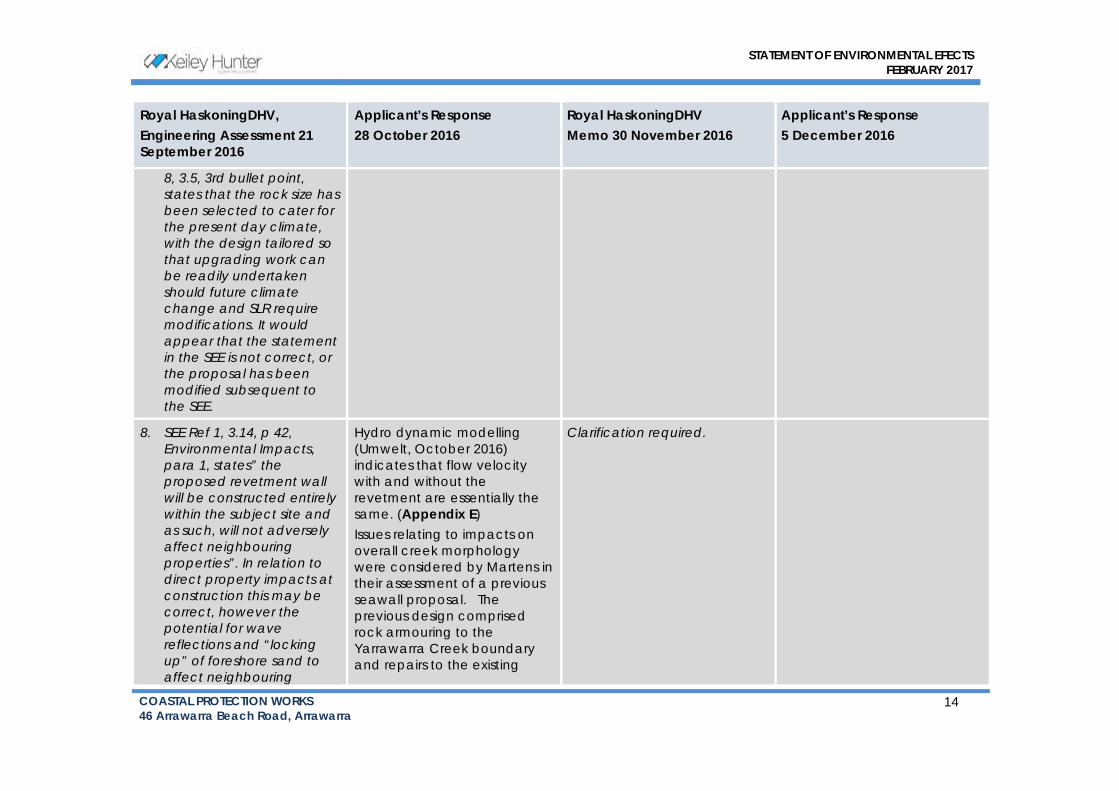
STATEMENT OF ENVIRONMENTAL EFECTS
FEBRUARY 2017
COASTAL PROTECTION WORKS
46 Arrawarra Beach Road, Arrawarra 14
Royal HaskoningDHV,
Engineering Assessment 21
September 2016
Applicant’s Response
28 October 2016
Royal HaskoningDHV
Memo 30 November 2016
Applicant’s Response
5 December 2016
8, 3.5, 3rd bullet point, states that the rock size has been selected to cater for the present day climate, with the design tailored so that upgrading work can be readily undertaken should future climate change and SLR require modifications. It would appear that the statement in the SEE is not correct, or the proposal has been modified subsequent to the SEE.
8. SEE Ref 1, 3.14, p 42, Environmental Impacts, para 1, states” the proposed revetment wall will be constructed entirely within the subject site and as such, will not adversely affect neighbouring properties”. In relation to direct property impacts at construction this may be correct, however the potential for wave reflections and “locking up” of foreshore sand to affect neighbouring
Hydro dynamic modelling
(Umwelt, October 2016)
indicates that flow velocity
with and without the
revetment are essentially the
same. (Appendix E)
Issues relating to impacts on
overall creek morphology
were considered by Martens in
their assessment of a previous
seawall proposal. The
previous design comprised
rock armouring to the
Yarrawarra Creek boundary
and repairs to the existing
Clarification required.

STATEMENT OF ENVIRONMENTAL EFECTS
FEBRUARY 2017
COASTAL PROTECTION WORKS
46 Arrawarra Beach Road, Arrawarra 15
Royal HaskoningDHV,
Engineering Assessment 21
September 2016
Applicant’s Response
28 October 2016
Royal HaskoningDHV
Memo 30 November 2016
Applicant’s Response
5 December 2016
properties would not appear to be considered.
Outcome: Insufficient information is provided on the quantum of referred erosion impacts to neighbouring properties and how these are to be managed. Comment: Ref 1, 3.3, discusses funding arrangements for ongoing maintenance of the seawall. Information is lacking on how these arrangements would be extended to manage potential offsite impacts to neighbouring properties.
gabion sea wall at the
Arrawarra Creek boundary.
A copy of the Martens
Geomorphic Impact
Assessment at Appendix M.
9. SEE Ref 1, 3.16, para 1, refers to Council’s “stormwater outlet”. It is not clear where this is. It does not appear to be referred to elsewhere in the background briefing information.
Outcome:
The stormwater outlet is
located within Lot 101 DP
1122639 adjacent to the north-
western corner of the site as
shown in the image below
(green circle):
Continual erosion to the north-
west area of the embankment
is likely to have been
compounded by the
construction, presumably by
Closed Out. No further action required

STATEMENT OF ENVIRONMENTAL EFECTS
FEBRUARY 2017
COASTAL PROTECTION WORKS
46 Arrawarra Beach Road, Arrawarra 16
Royal HaskoningDHV,
Engineering Assessment 21
September 2016
Applicant’s Response
28 October 2016
Royal HaskoningDHV
Memo 30 November 2016
Applicant’s Response
5 December 2016
Information is lacking on the details of Council’s “stormwater outlet”.
Council, of a stormwater pipe
concentrating the stormwater
runoff from Arrawarra Village
homes and roadways into that
part of the creek, the results
have been undermining and
collapse of the concrete
public access stairs and the
greatly intensified
embankment erosion in this
vicinity.
The stormwater outlet:

STATEMENT OF ENVIRONMENTAL EFECTS
FEBRUARY 2017
COASTAL PROTECTION WORKS
46 Arrawarra Beach Road, Arrawarra 17
Royal HaskoningDHV,
Engineering Assessment 21
September 2016
Applicant’s Response
28 October 2016
Royal HaskoningDHV
Memo 30 November 2016
Applicant’s Response
5 December 2016
10. The MHWM boundary is not clearly defined on the CES design layout for the seawall. This should clearly mark start and end point of each line segment that defines this boundary, with numbering of the line segments cross-referenced to a table on the CES drawings. This table should indicate each line segment, line bearing and distance as shown on DP 1209371 registered 19/6/15
Outcome: The definition of the MHWM property boundary is not adequate on the CES drawings.
Whilst the line of MHWM is
included in the design
drawings, the necessary scale
of the drawing makes it
difficult to identify that
particular line without masking
other more important
information.
To address this issue, the
sixteen drawings numbered
15‐849nsw‐03 to 18 all clearly
show the position of the
MHWM boundary, its location
in relation to the proposed
works and its location to
existing land contours
(Appendix C). Upon review,
we cannot see how this could
be made any clearer.
Closed out. No further action required

STATEMENT OF ENVIRONMENTAL EFECTS
FEBRUARY 2017
COASTAL PROTECTION WORKS
46 Arrawarra Beach Road, Arrawarra 18
Royal HaskoningDHV,
Engineering Assessment 21
September 2016
Applicant’s Response
28 October 2016
Royal HaskoningDHV
Memo 30 November 2016
Applicant’s Response
5 December 2016
11. Ref 8, 2.4, para 5, gives overtopping rates for varied damage behaviour behind a seawall, but no overtopping rates are reported for the developed site.
Outcome: Design overtopping rates so overtopping impacts cannot be suitably assessed or a management strategy developed as there is insufficient information.
A critical consideration of the
design was the determination
of overtopping rates along
sections of the proposed wall.
For the section of the
revetment having the crest
level of RL+3.0m AHD, the
overtopping rate is dependent
upon the incident wave
period, but is in excess of
0.4m3/sec/m. This indicates
scour of the material behind
the structure will occur.
Since this will occur in the 20‐metre (E2) buffer to
infrastructure, this is deemed
by the design process as an
acceptable outcome (since
the damage can be repaired)
provided the crest armour
does not suffer excessive
damage or fail.
The placement of rocks
greater than 3 tonnes as
buttress rocks to the rear of the
crest is intended to achieve
this performance outcome.
For the section of revetment
with a crest level at RL+2.0m
AHD, the structure will be
Design wave overtopping in excess of 400L/s per m predicted which is a very high value. Further investigation on overtopping impacts and remediation required.
Response – Paul O’Brien, Water
Technology:
The concerns of RHDHV
regarding the very high rates of
overtopping are shared by the
revetment designers. Indeed,
as noted in the Design Report
and subsequent responses to
Requests for Information, it has
been a significant focus of
design efforts. The outcome of
those design efforts is that the
special armouring is required on
crest of the structure and across
the width of the E2 Zone. Such
design techniques are widely
used by coastal engineers to
ensure the structural integrity of
the revetment and land levels
behind it during the 100 year
ARI storm event. Any grassing
or vegetation within the E2 Zone
will be damaged, but not the
revetment structure itself nor
any essential infrastructure
behind it.
We note that the concerns of
RHDV appear to relate to the

STATEMENT OF ENVIRONMENTAL EFECTS
FEBRUARY 2017
COASTAL PROTECTION WORKS
46 Arrawarra Beach Road, Arrawarra 19
Royal HaskoningDHV,
Engineering Assessment 21
September 2016
Applicant’s Response
28 October 2016
Royal HaskoningDHV
Memo 30 November 2016
Applicant’s Response
5 December 2016
submerged by approximately
1 metre during the 100 year
ARI storm tide / wave event,
as well as by the 100 year ARI
flood. The design of the
armoured slope is such that it
will remain structurally intact. It
is intended to cause waves
approaching and passing over
the structure to break within
the 20‐metre wide buffer of
the E2 zone. This is why 2 layers
of 0.1 tonne rock armour is
extended as a buried scour
apron across the entire E2
zone on this type of wall. The
extensive filling to otherwise
raise the wall to mitigate this
wave overtopping was
deemed by the design
process as an unacceptable
modification to existing creek
banks and the E2 zone.
“safety implications for severe
wave overtopping to carry
across the 20m E2 buffer”.
RHDHV have not opined that
the structural design of the crest
is in some way inadequate, but
instead that there could be a
safety issue associated with
people being in the
overtopping area during a 100
year ARI storm. Whilst that is
certainly a valid safety issue (as
it is for the entire shoreline
during such events), it does not
affect the structural
characteristics of the
revetment.
16. Ref 8, 3.4.2, has selected a 130m wide scoured entrance channel with bed level +0.2 m AHD for assessment of design wave penetration to the site. We are concerned that +0.2 m AHD based on a single
We do not believe that the
methodology suggested (of
using recorded water levels at
other estuaries) to infer the
scoured width and level of the
entrance berm of Arrawarra
Creek as a consequence of
the 100 year ARI event is any
More detailed assessment required to demonstrate selection of +0.2m AHD saddle level. In absence of further assessment and based on RHDHV review of comparable creek systems in NSW, it is
Refer to response above.
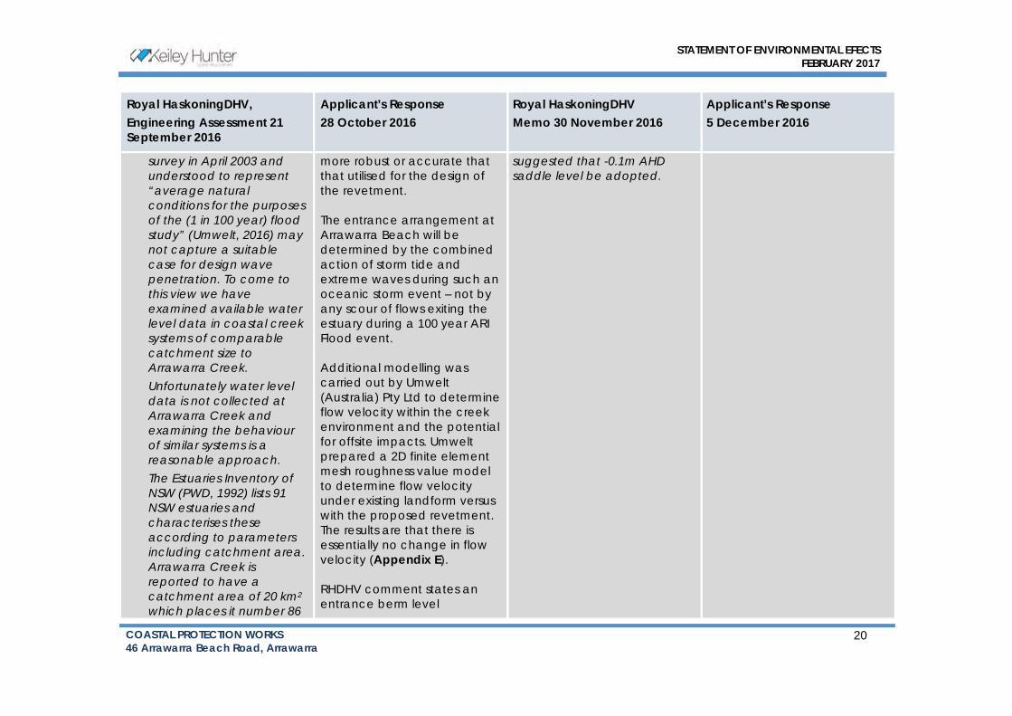
STATEMENT OF ENVIRONMENTAL EFECTS
FEBRUARY 2017
COASTAL PROTECTION WORKS
46 Arrawarra Beach Road, Arrawarra 20
Royal HaskoningDHV,
Engineering Assessment 21
September 2016
Applicant’s Response
28 October 2016
Royal HaskoningDHV
Memo 30 November 2016
Applicant’s Response
5 December 2016
survey in April 2003 and understood to represent “average natural conditions for the purposes of the (1 in 100 year) flood study” (Umwelt, 2016) may not capture a suitable case for design wave penetration. To come to this view we have examined available water level data in coastal creek systems of comparable catchment size to Arrawarra Creek. Unfortunately water level data is not collected at Arrawarra Creek and examining the behaviour of similar systems is a reasonable approach. The Estuaries Inventory of NSW (PWD, 1992) lists 91 NSW estuaries and characterises these according to parameters including catchment area. Arrawarra Creek is reported to have a catchment area of 20 km2 which places it number 86
more robust or accurate that
that utilised for the design of
the revetment.
The entrance arrangement at
Arrawarra Beach will be
determined by the combined
action of storm tide and
extreme waves during such an
oceanic storm event – not by
any scour of flows exiting the
estuary during a 100 year ARI
Flood event.
Additional modelling was
carried out by Umwelt
(Australia) Pty Ltd to determine
flow velocity within the creek
environment and the potential
for offsite impacts. Umwelt
prepared a 2D finite element
mesh roughness value model
to determine flow velocity
under existing landform versus
with the proposed revetment.
The results are that there is
essentially no change in flow
velocity (Appendix E).
RHDHV comment states an
entrance berm level
suggested that -0.1m AHD saddle level be adopted.
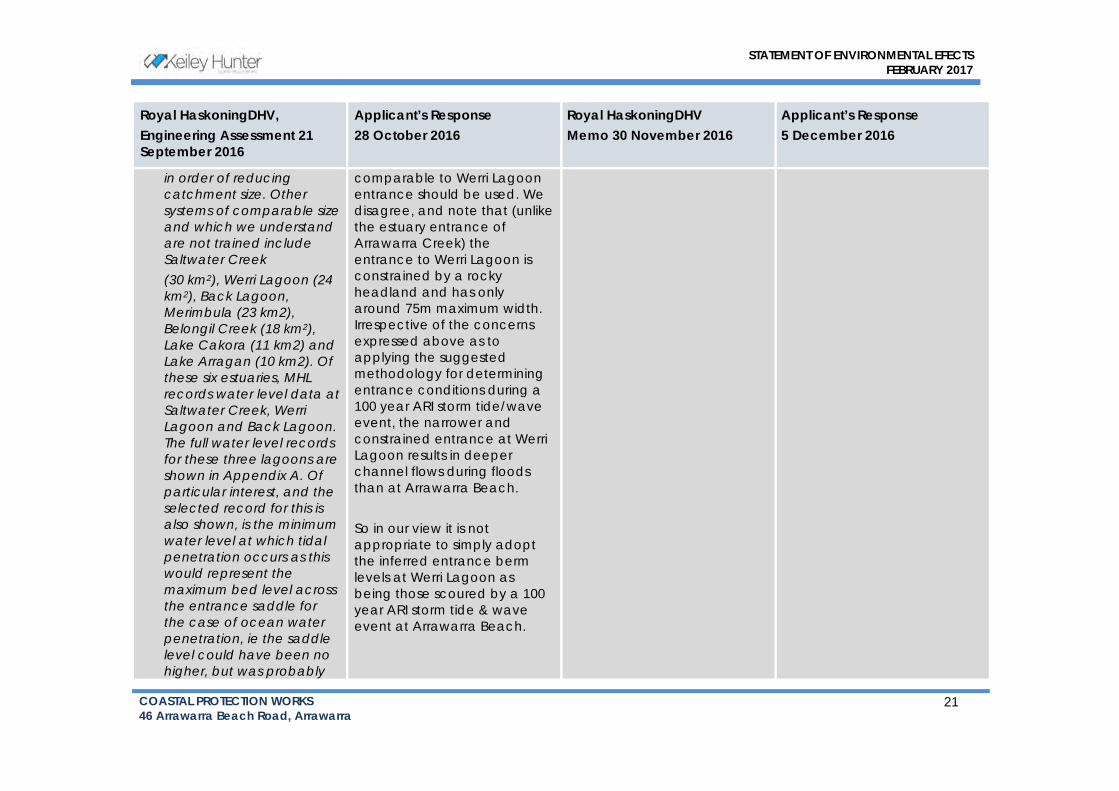
STATEMENT OF ENVIRONMENTAL EFECTS
FEBRUARY 2017
COASTAL PROTECTION WORKS
46 Arrawarra Beach Road, Arrawarra 21
Royal HaskoningDHV,
Engineering Assessment 21
September 2016
Applicant’s Response
28 October 2016
Royal HaskoningDHV
Memo 30 November 2016
Applicant’s Response
5 December 2016
in order of reducing catchment size. Other systems of comparable size and which we understand are not trained include Saltwater Creek (30 km2), Werri Lagoon (24 km2), Back Lagoon, Merimbula (23 km2), Belongil Creek (18 km2), Lake Cakora (11 km2) and Lake Arragan (10 km2). Of these six estuaries, MHL records water level data at Saltwater Creek, Werri Lagoon and Back Lagoon. The full water level records for these three lagoons are shown in Appendix A. Of particular interest, and the selected record for this is also shown, is the minimum water level at which tidal penetration occurs as this would represent the maximum bed level across the entrance saddle for the case of ocean water penetration, ie the saddle level could have been no
higher, but was probably
comparable to Werri Lagoon
entrance should be used. We
disagree, and note that (unlike
the estuary entrance of
Arrawarra Creek) the
entrance to Werri Lagoon is
constrained by a rocky
headland and has only
around 75m maximum width.
Irrespective of the concerns
expressed above as to
applying the suggested
methodology for determining
entrance conditions during a
100 year ARI storm tide/wave
event, the narrower and
constrained entrance at Werri
Lagoon results in deeper
channel flows during floods
than at Arrawarra Beach.
So in our view it is not
appropriate to simply adopt
the inferred entrance berm
levels at Werri Lagoon as
being those scoured by a 100
year ARI storm tide & wave
event at Arrawarra Beach.

STATEMENT OF ENVIRONMENTAL EFECTS
FEBRUARY 2017
COASTAL PROTECTION WORKS
46 Arrawarra Beach Road, Arrawarra 22
Royal HaskoningDHV,
Engineering Assessment 21
September 2016
Applicant’s Response
28 October 2016
Royal HaskoningDHV
Memo 30 November 2016
Applicant’s Response
5 December 2016
lower. Also included is a record of the water levels through the recent June 2016 storm event. We can see that for these three systems of comparable size to Arrawarra Creek, this limiting saddle level was approximately -0.4 m AHD for Werri Lagoon, -0.1 m AHD for Back Lagoon and 0.45 m AHD for Saltwater Lagoon. Having regard therefore to the information before us, RHDHV would be suggesting that a saddle level of -0.4 m AHD should therefore represent a maximum entrance saddle level for the calculation of design storm wave penetration. This is 0.6 m below the +0.2 m AHD saddle level adopted by the proponent which could be expected to lead to significantly higher wave

STATEMENT OF ENVIRONMENTAL EFECTS
FEBRUARY 2017
COASTAL PROTECTION WORKS
46 Arrawarra Beach Road, Arrawarra 23
Royal HaskoningDHV,
Engineering Assessment 21
September 2016
Applicant’s Response
28 October 2016
Royal HaskoningDHV
Memo 30 November 2016
Applicant’s Response
5 December 2016
penetration. Outcome: Insufficient justification is given regarding the selection of +0.2 m AHD as an appropriate entrance saddle level for design wave penetration. With water level data not collected for Arrawarra Creek, inspection of water level records for comparable NSW estuary systems indicates that a saddle level at least 0.6 m lower should reasonably apply.
19. Ref 8 uses van der Meer (1988) to calculate armour rock sizes for a 100 year ARI storm event, finding that a 1 tonne (T) primary armour with minimum rock density 2.65 T/m3 placed to a slope of 1:1.5 meets the requirements of van de Meer for 5% damage. RHDHV is comfortable with the assumptions and general calculation approach, however we
Refer to sample calculations
indicating two layers of 1
tonne primary armour
(Appendix C).
Calculations refer to
equation/page numbers in
CIRIA (2007).
RHDHV accepts vd Meer (1988) as reported in CIRIA (2007). Prudent to construct non-government owned seawall today to withstand 0.8m SLR to 2100. Adopted saddle level of +0.2m AHD should be reviewed. Ensure seawall setback to MHWM boundary.
No further action required.
Noted.

STATEMENT OF ENVIRONMENTAL EFECTS
FEBRUARY 2017
COASTAL PROTECTION WORKS
46 Arrawarra Beach Road, Arrawarra 24
Royal HaskoningDHV,
Engineering Assessment 21
September 2016
Applicant’s Response
28 October 2016
Royal HaskoningDHV
Memo 30 November 2016
Applicant’s Response
5 December 2016
find that the rock masses reported in Table 7 range between approximately one half to one third that specified using van de Meer (1988). We have applied Table VI-5-23 in Coastal Engineering Manual to complete our calculation checks, making reasonable assumptions of porosity (P=0.45), relative eroded area or damage (S=2.5) and applying the wave height modification for depth-limited waves (H=H2% /1.4). We have also applied Hudson (SPM, 1984) to cross-check our assessment. Provisional calculations by RHDHV indicate that providing for primary armour comprising at least 2 layers of 2T median rock (all other parameters unchanged) should provide for suitable seawall
The seawall I s set back
landward of the MHWM
boundary.
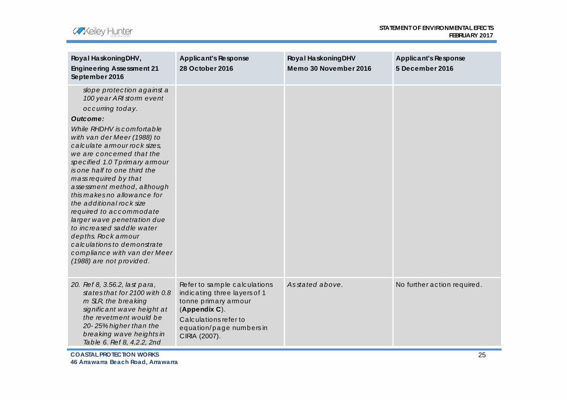
STATEMENT OF ENVIRONMENTAL EFECTS
FEBRUARY 2017
COASTAL PROTECTION WORKS
46 Arrawarra Beach Road, Arrawarra 25
Royal HaskoningDHV,
Engineering Assessment 21
September 2016
Applicant’s Response
28 October 2016
Royal HaskoningDHV
Memo 30 November 2016
Applicant’s Response
5 December 2016
slope protection against a 100 year ARI storm event occurring today.
Outcome: While RHDHV is comfortable with van der Meer (1988) to calculate armour rock sizes, we are concerned that the specified 1.0 T primary armour is one half to one third the mass required by that assessment method, although this makes no allowance for the additional rock size required to accommodate larger wave penetration due to increased saddle water depths. Rock armour calculations to demonstrate compliance with van der Meer (1988) are not provided.
20. Ref 8, 3.56.2, last para, states that for 2100 with 0.8 m SLR, the breaking significant wave height at the revetment would be 20- 25% higher than the breaking wave heights in Table 6. Ref 8, 4.2.2, 2nd
Refer to sample calculations
indicating three layers of 1
tonne primary armour
(Appendix C).
Calculations refer to
equation/page numbers in
CIRIA (2007).
As stated above. No further action required.

STATEMENT OF ENVIRONMENTAL EFECTS
FEBRUARY 2017
COASTAL PROTECTION WORKS
46 Arrawarra Beach Road, Arrawarra 26
Royal HaskoningDHV,
Engineering Assessment 21
September 2016
Applicant’s Response
28 October 2016
Royal HaskoningDHV
Memo 30 November 2016
Applicant’s Response
5 December 2016
para, states that when 0.8 m depth added to the design storm tide and wave heights are increased accordingly, then one additional layer of primary armour rocks would accommodate the additional wave loads. Provisional calculations by RHDHV indicate that providing for an additional 2 layers of 2T median rock (all other parameters unchanged) should provide for suitable seawall slope protection to the end of a structure life at 2100. The above assessment is based on the wave climate assessment assuming the +0.2 m AHD entrance saddle level. The additional water depth across the entrance saddle (Item 16) would lead to larger wave penetration and further increase the rock size in the revetment.

STATEMENT OF ENVIRONMENTAL EFECTS
FEBRUARY 2017
COASTAL PROTECTION WORKS
46 Arrawarra Beach Road, Arrawarra 27
Royal HaskoningDHV,
Engineering Assessment 21
September 2016
Applicant’s Response
28 October 2016
Royal HaskoningDHV
Memo 30 November 2016
Applicant’s Response
5 December 2016
Outcome: RHDHV notes that the Coastal Panel is receptive to an adaptive approach to increase the capacity of the seawall over its life (Ref 4, last bullet point). However, RHDHV is concerned that the adaptive modification proposed in Ref 8 may not suffice to provide suitable protection to the end of structure life. Suitably detailed calculations are not provided which demonstrate the acceptability of the proposed adaptive approach. Increasing the size of the additional (adaptive) rock layers, considered to be necessary by RHDHV, would require the seawall to be initially located further landward from the existing MHWM property boundary than is currently proposed.
21. Ref 8, Figure 9 seems to show the NE end of the seawall terminating some 80 m short of the end
The drawings show the
accurate set‐out of the
proposed works and are
drawn to scale. The figure in
Closed out.

STATEMENT OF ENVIRONMENTAL EFECTS
FEBRUARY 2017
COASTAL PROTECTION WORKS
46 Arrawarra Beach Road, Arrawarra 28
Royal HaskoningDHV,
Engineering Assessment 21
September 2016
Applicant’s Response
28 October 2016
Royal HaskoningDHV
Memo 30 November 2016
Applicant’s Response
5 December 2016
termination point shown in the design drawings.
Outcome: Certificate required
the report shows indicative
extents only.
It is noted that the drawings
are for DA purposes.
Technical drawings would be
provided with the CC
documentation.
22. The seawall proposal assumes design scour levels at the toe of the wall ranging between -1.0 and -0.5 m AHD, based on this meeting a level equal to one median rock diameter below the local channel thalweg. The actual location of the thalweg was not reported. RHDHV is concerned that this approach may miss deeper localised scour that could occur during high creek flows, particularly during periods of low tail water levels. We have recently modelled, using MIKE21, creek outflows at another North Coast creek system where a design scour level of -1.5
Refer comment #3 above
(regarding the gabion wall).
Closed out. No further action required.

STATEMENT OF ENVIRONMENTAL EFECTS
FEBRUARY 2017
COASTAL PROTECTION WORKS
46 Arrawarra Beach Road, Arrawarra 29
Royal HaskoningDHV,
Engineering Assessment 21
September 2016
Applicant’s Response
28 October 2016
Royal HaskoningDHV
Memo 30 November 2016
Applicant’s Response
5 December 2016
m AHD was identified along a straight section of the protected creek bank, and locally deepened to -2m AHD and deeper at downstream spur walls. Seven Google earth photos at Arrawarra Creek between 2004 and 2013 show the channel hard up against the gabion wall in the vicinity of SOP 22 and 23 for 4 of the 7 photo dates. It would be of interest to know what the minimum channel bed level may have been against the gabion wall during this period. Furthermore, if there is evidence of the gabion wall having settled in this area, it would be important to know the design toe level for the gabion wall and the existing settled toe level. Note that it is possible for a gabion wall to bridge a localised scour hole
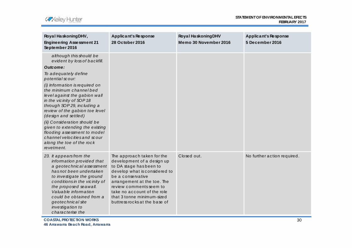
STATEMENT OF ENVIRONMENTAL EFECTS
FEBRUARY 2017
COASTAL PROTECTION WORKS
46 Arrawarra Beach Road, Arrawarra 30
Royal HaskoningDHV,
Engineering Assessment 21
September 2016
Applicant’s Response
28 October 2016
Royal HaskoningDHV
Memo 30 November 2016
Applicant’s Response
5 December 2016
although this should be evident by loss of backfill.
Outcome: To adequately define potential scour: (i) Information is required on the minimum channel bed level against the gabion wall in the vicinity of SOP 18 through SOP 29, including a review of the gabion toe level (design and settled) (ii) Consideration should be given to extending the existing flooding assessment to model channel velocities and scour along the toe of the rock revetment.
23. It appears from the information provided that a geotechnical assessment has not been undertaken to investigate the ground conditions in the vicinity of the proposed seawall. Valuable information could be obtained from a geotechnical site investigation to characterise the
The approach taken for the
development of a design up
to DA stage has been to
develop what is considered to
be a conservative
arrangement at the toe. The
review comments seem to
take no account of the role
that 3 tonne minimum‐sized
buttress rocks at the base of
Closed out. No further action required.

STATEMENT OF ENVIRONMENTAL EFECTS
FEBRUARY 2017
COASTAL PROTECTION WORKS
46 Arrawarra Beach Road, Arrawarra 31
Royal HaskoningDHV,
Engineering Assessment 21
September 2016
Applicant’s Response
28 October 2016
Royal HaskoningDHV
Memo 30 November 2016
Applicant’s Response
5 December 2016
subsurface conditions. The work could be expected to include a site walk over by an experienced geotechnical engineer, an assessment of the regional geotechnical context from geological mapping, and intrusive investigations. Techniques might include test pits along the footprint of the proposed seawall including along the toe of the gabion wall, boreholes, CPTs, and DCPs. A suitably designed geotechnical investigation will provide important baseline information to assist develop an appropriate toe detail for the seawall and provide design certainty.
Outcome: No geotechnical investigation would appear to be included in the background briefing information. To properly inform the seawall toe design it would be highly desirable to conduct
the wall plays in self‐armouring
the foundation.
A Geotechnical Assessment is
provided at Appendix O.
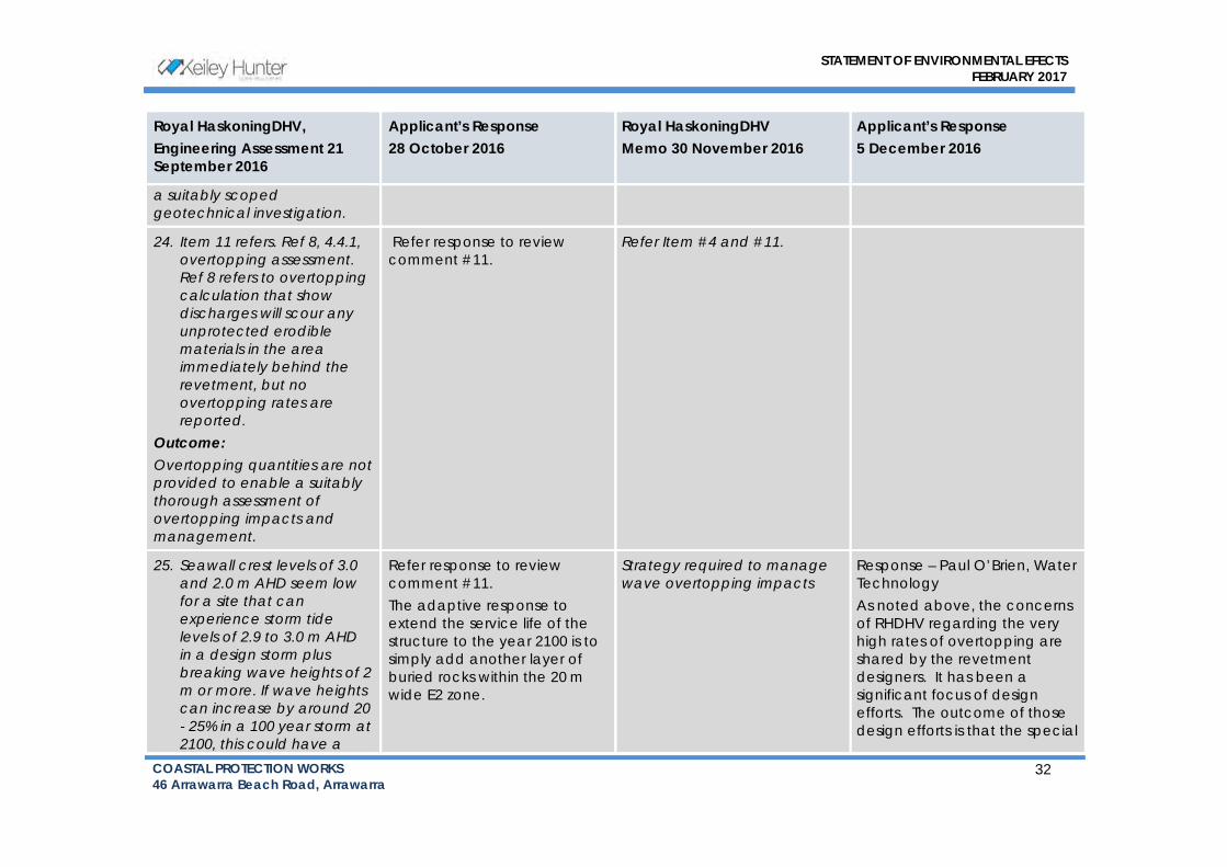
STATEMENT OF ENVIRONMENTAL EFECTS
FEBRUARY 2017
COASTAL PROTECTION WORKS
46 Arrawarra Beach Road, Arrawarra 32
Royal HaskoningDHV,
Engineering Assessment 21
September 2016
Applicant’s Response
28 October 2016
Royal HaskoningDHV
Memo 30 November 2016
Applicant’s Response
5 December 2016
a suitably scoped geotechnical investigation.
24. Item 11 refers. Ref 8, 4.4.1, overtopping assessment. Ref 8 refers to overtopping calculation that show discharges will scour any unprotected erodible materials in the area immediately behind the revetment, but no overtopping rates are reported.
Outcome: Overtopping quantities are not provided to enable a suitably thorough assessment of overtopping impacts and management.
Refer response to review
comment #11.
Refer Item #4 and #11.
25. Seawall crest levels of 3.0 and 2.0 m AHD seem low for a site that can experience storm tide levels of 2.9 to 3.0 m AHD in a design storm plus breaking wave heights of 2 m or more. If wave heights can increase by around 20 - 25% in a 100 year storm at 2100, this could have a
Refer response to review
comment #11.
The adaptive response to
extend the service life of the
structure to the year 2100 is to
simply add another layer of
buried rocks within the 20m
wide E2 zone.
Strategy required to manage wave overtopping impacts
Response – Paul O’Brien, Water
Technology
As noted above, the concerns
of RHDHV regarding the very
high rates of overtopping are
shared by the revetment
designers. It has been a
significant focus of design
efforts. The outcome of those
design efforts is that the special

STATEMENT OF ENVIRONMENTAL EFECTS
FEBRUARY 2017
COASTAL PROTECTION WORKS
46 Arrawarra Beach Road, Arrawarra 33
Royal HaskoningDHV,
Engineering Assessment 21
September 2016
Applicant’s Response
28 October 2016
Royal HaskoningDHV
Memo 30 November 2016
Applicant’s Response
5 December 2016
significant impact on wave overtopping.
Outcome: Detailed information is lacking on the adaptive response to deal with what appear to be low seawall crest levels, particularly given the predicted 20-25% increase in design wave heights by year 2100.
armouring is required on crest of
the structure and across the
width of the E2 Zone.
We again note that the
concerns of RHDHV appear to
relate to the “safety implications
for severe wave overtopping to
carry across the 20m E2 buffer”
rather than the structural design
of the crest is in some way
inadequate.
26. Design drawing 15-
849NSW-02 B lists design
parameters. Wave height
H is given as 2.0 m with T =
7-12 s. Notwithstanding the
issue of inadequate saddle
depth and consequent
larger wave penetration,
it would be more
accurate for H = 1.9 to 2.3
m to be added to the
drawing to better reflect
Table 6 in Ref 8.
Outcome: Design drawing 15-849NSW- 02
B does not fully describe the
design wave height
This issue is not considered
critical in the determination of
the DA.
If necessary, any required
adjustments to seawall design
will be made to the final
construction drawing set.
Closed out. No further action required.

STATEMENT OF ENVIRONMENTAL EFECTS
FEBRUARY 2017
COASTAL PROTECTION WORKS
46 Arrawarra Beach Road, Arrawarra 34
Royal HaskoningDHV,
Engineering Assessment 21
September 2016
Applicant’s Response
28 October 2016
Royal HaskoningDHV
Memo 30 November 2016
Applicant’s Response
5 December 2016
Conclusion by RHDHV:
Various matters have now been satisfactorily addressed to assist the Coastal Panel in its consideration of the application. RHDHV is satisfied with vd Meer (1988) as described in CIRIA (2007) for sizing the rock armour, however we remain concerned that a design entrance saddle level of +0.2 m AHD is too elevated. Investigation is required to demonstrate the acceptability of this level. It is noted that a lower saddle level would permit larger wave penetration and require larger armour size. Design wave overtopping reported by WT as exceeding 400 L/s per m is of concern. The consequences and management of design wave overtopping, particularly at the exposed north-eastern portion of the seawall, needs to be addressed.

Astoria Group | 23 February 2017 Arrawarra Beach Caravan Park: Rock-Armoured Revetment
4362
-01_
R02
v02
Melbourne 15 Business Park Drive Notting Hill VIC 3168 Telephone (03) 8526 0800 Fax (03) 9558 9365
Brisbane Level 3, 43 Peel Street South Brisbane QLD 4101 Telephone (07) 3105 1460 Fax (07) 3846 5144
Wangaratta First Floor, 40 Rowan Street Wangaratta VIC 3677 Telephone (03) 5721 2650
Perth PO Box 362 Subiaco WA 6904 Telephone 0407 946 051
Geelong PO Box 436 Geelong VIC 3220 Telephone 0458 015 664
Gippsland 154 Macleod Street Bairnsdale VIC 3875 Telephone (03) 5152 5833
Wimmera PO Box 584 Stawell VIC 3380 Telephone 0438 510 240
www.watertech.com.au