review on development of sdi as a basis of e-government in croatia ivan landek, assistant director...
TRANSCRIPT

Review on development of SDI as a basis of E-government in Croatia
Ivan Landek, assistant directorState Geodetic Administration of RoC
International Workshop onE-government and its Spatial DimensionSofia, Friday 9 June 2006

Content
Legal/ reference framework Institutional setup Implementational frame SGA vision 2010. Croatian Spatial Data Infrastructure Creating digital spatial environment Cadastre data viewer Comming - SGA Geoportal

Present legal framework
Law on State Survey and Real-Estate Cadastre (1999.)
Law on Physical Planning (1994.) Law on Electronic Signature (2002.) Law on Protection of Copyrights (2003.) Various Laws that enact establishment of
georeferenced and GIS based registers

Reference framework Number of studies produced for SGA in period
2001.-2004. Government of Republic of Croatia has adopted:
Decree on Introduction of Geodetic Datums and plain cartogtraphic projection (August 4th 2004.)
Reasons for this step were: Croatia gaining independence Establishment of modern Cadastral and Spatial system in
Croatia Removing obstacles for efficient usage of GIS and IT Creating preconditions for development of informatic society in
Croatia

Institutional setup Croatian Government – heighest strategic decisions Central State Administration Office for e-Croatia –
coordinating establishment and performs a strategy for e-Government
Ministry of Environmental Protection, Physical Planning and Construction – governmental authority for SGA (key factor)
State Geodetic Administration implementation of Croatian SDI standards and specifications production and dissemination of basic spatial data sets/bases

Implementational frame
Governmental Program for period 2003.-2007.
EU AVIS Program on State Survey and Real-Estate
Cadastre for period 2006.-2010. Program on Implementation of new
Geodetic Datums and Cartographic Projection

Strategic goals 2006.-2010. IT-environment - establishment of fully
digitalized authority (e-Hrvatska) Customer orientation – delivery of services
according to the needs of our customers Contribution to general welfare Modernization of business model
SGA vision 2010.

SDI is integral part of Croatian government policies for information
systems and public information availabilitiy
Main goals of NSDI for ROC
Improvement of basis for good governance Support for economic development Fulfillment of criteria for joining EU
Croatian SDI

Vision of NSDI in ROC Open market for sharing geoinformation with increased
offer and usage of spatial data Open spatial network through integration of NSDI in E-
administration State – private – academic consensus driven partnership NSDI must be integral part of E-government
infrastructure Connecting private sector with state and international
spatial data network Decision support for government, citizens and private
companies
Croatian SDI

Creating digital spatial environment in Croatia
Creating appropriate legal frameworkEstablishment of NSDI bodiesDevelopment of NSDI tools Creation of joint feeling for NSDITransfering spatial data sets into the
NSDI environmentHard work for number of years

Appropriate legal framework
New Law on State Survey and Real-Estate Cadastre contains chapter about NSDI; including its definition, content, tasks, subjects and participants, bodies and
deadlines
In procedure, it will be adopted during this year!
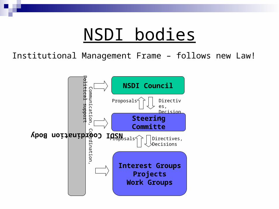
Institutional Management Frame – follows new Law!
NSDI bodies
NSDI Coordination Body
Interest GroupsProjects
Work Groups
Steering Committe
NSDI Council
Proposals Directives,Decisions
Proposals Directives,Decisions
Co
mm
un
icatio
n, C
oo
rdin
atio
n, P
olitica
l sup
po
rt

NSDI Tools
Cadastre Data ViewerE-Land RegistryGeoportal Metadata Service (part of the Geoportal)CROTIS and other SpecificationsCROPOS

Cadastre data viewer

Cadastre data viewer – e-Cadstre
Cadastre data viewer – for insight in Central database of cadastre data for ROC
Central database of cadastre data is managed from Central office of SGA and it unifies official data from 115 cadastre offices
Main principle is “completeness” – insight in cadastre data for whole ROC
Parcel number Ownership document number in chosen cadastre
municipality

Cadastre data viewer – e-Cadstre
Project objectives: Secure legal trade of real estates Development of real estates market – development of
whole economy Presenting cadastre data on public insight Building confidence in this important state register Motivate citizens and other subjects to update the
contents of inscribed data
Project users: State bodies, economy, citizens = EVERYBODY

Requirement/goal-levels
INSPIRE
NSDI
SGA
GeoPortal
Comming – SGA Geoportal

Comming – SGA Geoportal Portal for accessing various spatial data Organized set of links towards other spatial web resources
data services applications publishing help
myAccount | myOrders | myDownloads | log off
browsesearch
Where do you want to search?
data
data
Text eingeben
Type
Theme
Keyword
What are you looking for?
Start my search
Locate in the map
Or find a place by name
Text eingebenPlacename
homeSGA.Geoportal
News
Promotion
Partners
I am a blind text and my purpose is to fill space. I am a blind text and my purpose is to fill space. I am a blind text and my purpose is to fill space. I am a blind text and my purpose is to fill space. I am a blind text and my purpose is to fill space. I am a blind text and my purpose is to fill space. I am a
06.02.2006: Headline
I am a blind text and my purpose is to fill space. I am a blind text and my purpose is to fill space. I am a blind text and my purpose is to fill space. I am a blind text and my purpose is to fill space. I am a blind text and my purpose is to fill space. I am a blind text and my purpose is to fill space.
06.02.2006: Headline
Welcome back, <USER>! (you have new messages)

Data sets available in the first phase: Croatian Base Map 1:5.000 (raster) Digital Ortophoto Map 1:5.000 (raster) Cadastre Maps (raster) Central Register of Spatial Units Permanent Geodetic Reference Points
Untill 2010. all data should be available on the Geoportal!
Comming – SGA Geoportal

THANK YOU FOR YOUR ATTENTATION !!