review the mysteries of mammatus clouds: observations and...
TRANSCRIPT

REVIEW
The Mysteries of Mammatus Clouds: Observations and Formation Mechanisms
DAVID M. SCHULTZ,*,� KATHARINE M. KANAK,* JERRY M. STRAKA,# ROBERT J. TRAPP,@
BRENT A. GORDON,& DUSAN S. ZRNIC,� GEORGE H. BRYAN,** ADAM J. DURANT,��
TIMOTHY J. GARRETT,## PETRA M. KLEIN,# AND DOUGLAS K. LILLY@@
*Cooperative Institute for Mesoscale Meteorological Studies, University of Oklahoma, Norman, Oklahoma�NOAA/National Severe Storms Laboratory, Norman, Oklahoma
#School of Meteorology, University of Oklahoma, Norman, Oklahoma@Department of Earth and Atmospheric Sciences, Purdue University, West Lafayette, Indiana
&NOAA/NWS/NCEP, Camp Springs, Maryland** National Center for Atmospheric Research, Boulder, Colorado
��Department of Geological/Mining Engineering & Sciences, Michigan Technological University, Houghton, Michigan##Department of Meteorology, University of Utah, Salt Lake City, Utah
@@University of Nebraska at Kearney, Kearney, Nebraska
(Manuscript received 18 August 2005, in final form 20 January 2006)
ABSTRACT
Mammatus clouds are an intriguing enigma of atmospheric fluid dynamics and cloud physics. Mostcommonly observed on the underside of cumulonimbus anvils, mammatus also occur on the underside ofcirrus, cirrocumulus, altocumulus, altostratus, and stratocumulus, as well as in contrails from jet aircraft andpyrocumulus ash clouds from volcanic eruptions. Despite their aesthetic appearance, mammatus have beenthe subject of few quantitative research studies. Observations of mammatus have been obtained largelythrough serendipitous opportunities with a single observing system (e.g., aircraft penetrations, visual ob-servations, lidar, radar) or tangential observations from field programs with other objectives. Theoriesdescribing mammatus remain untested, as adequate measurements for validation do not exist because of thesmall distance scales and short time scales of mammatus. Modeling studies of mammatus are virtuallynonexistent. As a result, relatively little is known about the environment, formation mechanisms, properties,microphysics, and dynamics of mammatus.
This paper presents a review of mammatus clouds that addresses these mysteries. Previous observationsof mammatus and proposed formation mechanisms are discussed. These hypothesized mechanisms are anvilsubsidence, subcloud evaporation/sublimation, melting, hydrometeor fallout, cloud-base detrainment insta-bility, radiative effects, gravity waves, Kelvin–Helmholtz instability, Rayleigh–Taylor instability, and Ray-leigh–Bénard-like convection. Other issues addressed in this paper include whether mammatus are com-posed of ice or liquid water hydrometeors, why mammatus are smooth, what controls the temporal andspatial scales and organization of individual mammatus lobes, and what are the properties of volcanic ashclouds that produce mammatus? The similarities and differences between mammatus, virga, stalactites, andreticular clouds are also discussed. Finally, because much still remains to be learned, research opportunitiesare described for using mammatus as a window into the microphysical, turbulent, and dynamical processesoccurring on the underside of clouds.
1. Introduction
The Glossary of Meteorology defines mammatusclouds (or mamma) as “hanging protuberances, likepouches, on the undersurface of a cloud” (Glickman
2000, p. 471). The word mammatus is Latin for “havingbreasts.” A characteristic of mammatus is their oftensmooth, laminar appearance, which makes them someof the most distinctive clouds in our atmosphere (Figs.1 and 2). Their aesthetic appearance when illuminatedby the colors of sunset, have made mammatus a popularsubject of photographers and artists. For example, Ged-zelman (1989) noted that mammatus have appeared inpaintings as early as the 1500s.
Mammatus often occur on the edges and sloping un-
Corresponding author address: Dr. David M. Schultz, NOAA/National Severe Storms Laboratory/FRDD, Suite 4356, Norman,OK 73072-7326.E-mail: [email protected]
VOLUME 63 J O U R N A L O F T H E A T M O S P H E R I C S C I E N C E S OCTOBER 2006
© 2006 American Meteorological Society 2409
JAS3758

derside of cumulonimbus (e.g., Fig. 1a) and have beenobserved on both the upshear and downshear sides ofthe outflow anvil. Although cumulonimbus anvil mam-matus is the most commonly noted and photographed,mammatus can occur in other cloud types as well. Ley
(1894, pp. 84–86, 104), who appears to have originatedthe term mammatus (Berry et al. 1945, p. 891), identi-fied two types: cumulonimbus anvil mammatus and cu-mulostratus (now known as stratocumulus) mammatus(e.g., Fig. 2e). German meteorologists in the early
FIG. 1. (a) Cumulonimbus anvil mammatus organized into lines, possibly along radiating gravity waves: 5 May2002, east of Silverton, TX (copyright C. A. Doswell III). (b) Pyrocumulus mammatus associated with the eruptionof Mount Redoubt on 21 Apr 1990 (photo by R. J. Clucas, from the U.S. Geological Survey Digital Data Series,DDS-039).
2410 J O U R N A L O F T H E A T M O S P H E R I C S C I E N C E S VOLUME 63
Fig 1 live 4/C

twentieth century also recognized that mammatusclouds could occur in association with altostratus, al-tocumulus, and cirrus. Scorer (1972) noted that mam-matus can occur on falling rain or snow below a cloud
base or on streaks of falling ice crystals. Ludlam andScorer (1953) observed mammatus-like features as jet-aircraft condensation trails broke up into pendulouslumps. Mammatus have even been observed on pyrocu-
FIG. 2. (a) Cumulonimbus anvil mammatus: 25 Mar 2005, Salt Lake City, UT (copyright J.Steenburgh). (b) Mammatus with ragged edges: 29 Jun 2004, Norman, OK (copyright K.Kanak and J. Straka). (c) Well-developed cumulonimbus anvil mammatus lobes: 29 May 2004,near Belleville, KS (copyright V. Doswell). (d) Cumulonimbus anvil mammatus arranged inlines, showing blue sky between lobes: 8 May 2005, Norman, OK (copyright C. A. DoswellIII). (e) Stratocumulus mammatus: 3 Aug 2003, Ouachita National Forest, OK (copyright D.Schultz). (f) Mammatus that formed on a cumulonimbus anvil that had all nearly evaporatedexcept for the leading edge: 2047 CDT 7 Jun 2004, Norman, OK (copyright K. Kanak and J.Straka). (g) Mammatus exhibiting breaking Kelvin–Helmholtz waves: 2 Aug 1992, Norman,OK (copyright K. Kanak and J. Straka). (h) Mammatus in the ash cloud from the Mount St.Helens eruption at 0832 Pacific daylight time (PDT) 18 May 1980: picture taken at about 0900PDT 18 May 1980, Richland, WA (copyright M. Orgill).
OCTOBER 2006 R E V I E W 2411
Fig 2 live 4/C

mulus clouds from volcanic eruptions (e.g., Stith 1995,p. 911; Figs. 1b and 2h and section 4g in the presentpaper). Note the similarities between cumulonimbusanvil mammatus and pyrocumulus mammatus in termsof the structures of the mammatus and their locationson the clouds (cf. Figs. 1a,b). The variety of situationsunder which mammatus form led Ley (1894) and Berg(1938), for example, to argue that these different typesof mammatus are likely formed by different processes.
Not all mammatus look the same, however. Some-times the surfaces of mammatus are laminar (e.g., Fig.2a), whereas other times they are ragged (e.g., Fig. 2b).Sometimes they can penetrate quite deeply from thecloud base into the subcloud air (e.g., Fig. 2c). Some-times they can occur on a thin part of the anvil so thatblue sky is seen between the lobes (e.g., Figs. 2d,f).
Because they are not directly related to significantweather events on the ground and they do not appar-ently hold insights into forecasting severe convectivestorms, mammatus generally have been viewed as nomore than a curiosity in the atmosphere. Consequently,published research on mammatus is rather limited, andwhat literature exists is either highly speculative or se-verely constrained by the limited nature of the obser-vations. The majority of observations of mammatus de-rives from serendipitous measurements using single ob-serving systems or from field programs with objectivesthat exclude studying mammatus. In some cases, al-though mammatus-like structures may be apparent inradar data or numerical model output, visual confirma-tion of mammatus may not even exist. Theories formammatus abound, but have rarely been rigorouslytested with observed data. Textbooks at all levels (un-dergraduate, graduate, general public) parrot thesetheories, leading to the further spread of misinforma-tion. In addition, laboratory experiments and numericalmodel simulations of mammatus initialized from ideal-ized or real-data initial conditions are lacking. As aresult, relatively little is known about the environment,origin, structure, size, microphysical properties, and dy-namics of mammatus.
The purpose of this paper is to discuss observationsof mammatus and to critically evaluate existing theo-ries. In this paper, we choose to broaden our scope toconsider mammatus and mammatus-like structureswhether or not they have been visually identified. Ob-servations with visual confirmation of mammatus struc-tures are especially valued because that seems to be theprimary means of identifying these curious cloud struc-tures, as they have been defined in the past. Further-more, because the atmosphere often resists being pi-geonholed into convenient little bins, this paper will
benefit from taking a broader perspective of the fea-tures on the undersides of clouds.
In section 2, previous observations of mammatus arereviewed. Particular attention is paid to the shapes,structures, microphysical compositions, and associa-tions with different parent clouds. An informed discus-sion of hypothesized formation mechanisms for mam-matus is presented in section 3. These theories areevaluated to the extent possible, in light of the availableobservational data. Section 4 contains discussions ofother issues regarding mammatus, including the typesof hydrometeors, their smoothness, and the factors thatcontrol their spatial/temporal scales and organization.The nature of mammatus formed in pyrocumulus fromvolcanic eruptions is also discussed, as are the similari-ties and differences between mammatus, virga, stalac-tites, and reticular clouds. Section 5 concludes this pa-per, addressing the types of observational data and nu-merical-model experimentation needed to begin toresolve some of these questions.
2. Observations of mammatus
The literature on mammatus from the first half of thetwentieth century comes mostly from German scientistsand is discussed in section 2a. Later quantitative obser-vations of mammatus, described in section 2b, arerather limited, amounting to perhaps a dozen studies(Table 1). Recently, several studies have presented ob-servations of cirrus mammatus; these studies are re-viewed in section 2c. In section 2d, we present datafrom a previously unpublished mammatus event, andwe revisit data from another event.
a. Early literature: 1900–48
This period of mammatus research within the Ger-man literature seems to have been inspired by Osthoff(1906). His seven-and-a-half-page paper described hisobservations of 67 mammatus events over 21 years. Hefound that mammatus were 10 times more likely tooccur during the summer than winter, with more thanhalf of the events occurring during 1400–1700 localstandard time (LST). Almost half (42.6%) of the eventswere associated with thunderstorms, squalls, or cumu-lonimbus, whereas 31.5% were associated with stra-tocumulus, 24.1% were associated with altocumulus ormiddle clouds, and 1.9% were associated with nimbus.His drawings of mammatus showed the variety of struc-tures he observed.
Inspired by Osthoff’s work, Wegener (1909) arguedthat discontinuities in temperature and wind across thecloud base would be observed in cumulonimbus anvil
2412 J O U R N A L O F T H E A T M O S P H E R I C S C I E N C E S VOLUME 63

mammatus as a result of the anvil spreading horizon-tally. Because the anvil outflow and the thunderstormenvironment would not necessarily have the same tem-perature and horizontal momentum, a thermal inver-sion and vertical wind discontinuity may be expected.This argument was supported by future observationalevidence, discussed later in this paper.
Clayton (1911) reported on four different cases ofmammatus sampled by kite soundings at the HarvardCollege Astronomical Observatory. Said Clayton(1911, p. 183), “In every case where the lower surface ofa cloud is mammated, the cloud is found above an in-verted gradient of temperature.” Hartmann (1920), inobservations of stratus mammatus passing over amountaintop observing station, observed a dry layerunderneath the mammatus in association with an inver-sion and strong wind shear. Further observations ofmammatus by Schneider (1920) from two instrumentedkite ascents showed an inversion of 0.7°–1.5°C at cloudbase. While most authors at this time believed thatmammatus were convex protuberances hanging downfrom cloud base, Schmauss (1913) argued, apparentlyunconvincingly, that an optical effect due to the illumi-nation of the underside of the cloud made it difficult todetermine whether mammatus were concave or convex.
Troeger (1921) observed stratus mammatus in asso-ciation with a 46° halo around the sun. (The 46° halo, orgreat halo, is caused by sunlight being refractedthrough horizontally falling, pencil-like ice columnswith hexagonal cross sections.) This work laterprompted him to perform a climatology of 100 cases of
mammatus (Troeger 1922), analogous to Osthoff’s.Troeger (1922) found that mammatus were 2 or 3 timesmore likely to occur in summer than winter, comparedto Osthoff’s (1906) 10 times. The editors of Meteorolo-gische Zeitschrift cautioned that Osthoff (1906) andTroeger (1922) likely had different definitions of mam-matus because of Osthoff’s lower frequency of mam-matus. Like Osthoff (1906), Troeger (1922) also foundan afternoon maximum in occurrence. He proposedtwo different mechanisms for mammatus formation.The first mechanism involved a moist stratus layer mov-ing over a very dry layer with evaporation of the lowerpart of the cloud resulting in mammatus. The secondmechanism occurred in the lower part of fall streaks orcirrus, where wind shear caused the settling particles toslow down, recirculate, and form mammatus. Troeger(1922) appears to have been the first to describe cirrusmammatus, although Bauman (1927) would later claimthat his observations of cirrus mammatus were the firstreported in the literature. (More discussion on cirrusmammatus can be found in section 2c.)
Of the mammatus research during the first half of thetwentieth century, that by Berg (1938) was arguably themost insightful. He discussed three types of mammatusand attributed each type to a different physical process.Altostratus mammatus were attributed to waves due toKelvin–Helmholtz instability (section 3h) across the in-version at cloud base. What Berg (1938) consideredcumulonimbus mammatus were fallstreaks. Altocumu-lus mammatus cumulogenitus (what would be calledcumulonimbus anvil mammatus today) developed
TABLE 1. Previous observational studies of mammatus. Types of observations: A � aircraft, GD � ground-based Doppler radar,AD � airborne Doppler radar, VD � vertically pointing Doppler radar, R � rawinsonde, L � lidar, P � stereo photogrammetry.N/A � not available. Height is in km MSL.
StudyPressure (hPa)[height (km)]
Temperature(°C)
Horizontalscale (km) Environment Obs w (m s�1)
Hlad (1944) I [1.28] �15 N/A Thunderstorm R N/AHlad (1944) II [3.66] �1 N/A Altostratus R N/AHlad (1944) III [3.96] �1 N/A Thunderstorm R/A N/AClarke (1962) 600 [4] �1 to �2 0.25–0.75 Cold front R N/AWarner (1973) [5–6.5] N/A 0.12–1.05
mean 0.35Hailstorm P �3.1 to �1.2
mean �2.3Stith (1995) 394 [7.3] �25 2–3 Hailstorm (supercell) A �2.5 to �1.0Martner (1995) [3–5] �1 to �11 1.1 Rain shower with anvil VD �3 to �0.5
mean �0.7Winstead et al. (2001) 450 [7] �20 1–3 Stratiform anvil between
supercellsAD �2 to �3
Wang and Sassen (2005) [7.4–8] �37 3–7 Cirrostratus transitioningto altostratus
L/VD �2 to �0.5
Jo et al. (2003) andKollias et al. (2005)
[5–6] �0 1–3 Convective anvil VD �5 to �1.5
This study 4 Aug 1992 [5.4–5.9] �0 0.5–2.0 MCC stratiform region GD/VP 0.0 to �3.5This study 14–15 Feb 2000 660 [2.97] �1.7 1–2 Pre-cold front GD N/A
OCTOBER 2006 R E V I E W 2413
when the overshooting top of a cumulonimbus hit thetropopause and spread out. Although Berg (1938) rec-ognized the existence of cirrus mammatus, he did notdiscuss it in detail.
Finally, Wagner (1948) suggested that a slowly sub-siding cloud base would generate instability as thecloudy air underwent saturated adiabatic descent andthe dry subcloud air underwent dry adiabatic descent.The result of this steepening lapse rate across the cloudbase may provide impetus for the formation of mam-matus.
b. Recent observations: 1944–present
Hlad (1944) investigated soundings associated withthree cases of mammatus in southern Texas. Two wereassociated with postconvective environments, whereasthe third was associated with a thin altostratus overcast.On one of the postconvective events, Hlad (1944, p.331) participated in an aircraft flight through the mam-matus and described the remarkable experience:
At 13,000 feet [3962 m] we entered the actual mam-matus cloud deck, although it didn’t appear to be acloud deck from a technical standpoint. There werevast openings where the visibilities were very good,below we could see trails of very heavy drops, yetthere was no rain striking the plane. The turbulencewas very light in these openings. Seeking an explana-tion, we went down to 12,000 feet [3658 m] and passedunder the rain trails.
There was no rain striking the plane at this leveleither, although looking above us we could see thelarge drops. Next we entered this “ball” of rain whichappeared to be suspended in the air. Inside, the raindrops were very heavy and the turbulence was mod-erate to heavy. After flying under, over, and throughseveral of these rain “balls,” the conclusion wasreached that they were the actual “sacks” that gavethe cloud deck above its mammatus appearance.These rain “sacks” extended as much as 1000 feet [305m] downward from the main deck and yet no rain fellfrom any of those that we passed under.
Hlad (1944) concluded that these rain sacks must besuspended by strong upward vertical motion (a hypoth-esis not verified by later observations from others) andthe lower boundary of the sacks were caused by evapo-ration of the rain drops (evaporation is one possiblemechanism for mammatus, see section 3b).
Clarke (1962) described mammatus on the undersideof a cold-frontal rainband of altocumulus and altostra-tus associated with virga, employing visual observationsand surface barograms. This field of mammatus wasapparently viewed simultaneously over a 300–500-km-long region in Australia. The mammatus were orga-
nized into lines believed to be associated with 1.5-hPasurface pressure perturbations moving at 27 m s�1.Richardson numbers less than or approximately equalto 0.25 in the region of mammatus suggested to Clarke(1962) that internal gravity waves formed on a low-levelinversion due to forcing from the mammatus circula-tions.
Warner (1973) employed stereo photogrammetry toanalyze the characteristics of mammatus in a time-lapsemovie of a hailstorm in Alberta. The average lifetime of14 mammatus lobes was 10 min, the average diameterof 54 lobes was 350 m, and the mean vertical velocity of13 lobes was �2.3 m s�1, with a range of �3.1 to �1.2m s�1 (Table 1).
Stith (1995) flew through two cumulonimbus mam-matus lobes over North Dakota using the University ofNorth Dakota Citation aircraft and particle measuringsystems. Like Hlad (1944), Stith (1995) also noted thatthe mammatus were not opaque. Within the lobes, thehydrometeors were composed mostly of aggregated iceparticles with some rounded ice particles (i.e., frozendrops). Liquid water was not observed in large quanti-ties. The main descending portions of the mammatuslobes were 0.7°C warmer than the ambient air, althoughnot very turbulent (approximately 0.2–0.3g, just barelywithin the range considered light turbulence by pilots).Vertical air motions measured by the plane were com-parable to fall speeds for larger ice crystals (�2 m s�1),so these falling particles were likely staying within themammatus lobes.
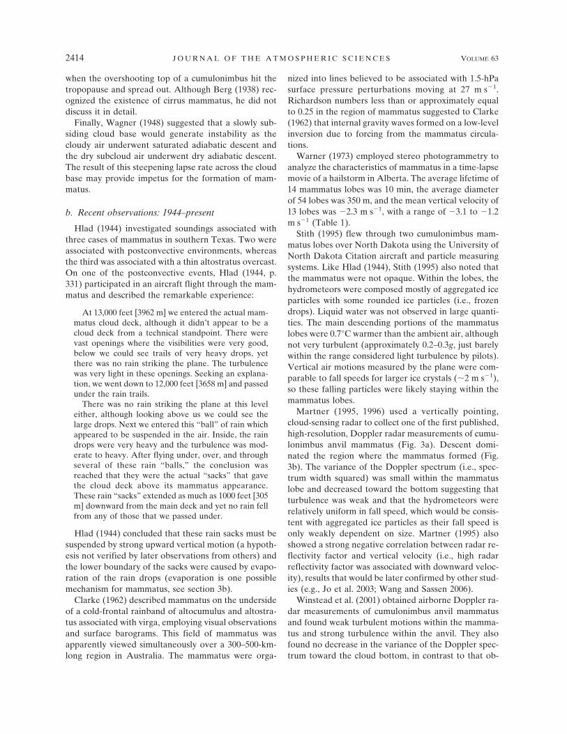
Martner (1995, 1996) used a vertically pointing,cloud-sensing radar to collect one of the first published,high-resolution, Doppler radar measurements of cumu-lonimbus anvil mammatus (Fig. 3a). Descent domi-nated the region where the mammatus formed (Fig.3b). The variance of the Doppler spectrum (i.e., spec-trum width squared) was small within the mammatuslobe and decreased toward the bottom suggesting thatturbulence was weak and that the hydrometeors wererelatively uniform in fall speed, which would be consis-tent with aggregated ice particles as their fall speed isonly weakly dependent on size. Martner (1995) alsoshowed a strong negative correlation between radar re-flectivity factor and vertical velocity (i.e., high radarreflectivity factor was associated with downward veloc-ity), results that would be later confirmed by other stud-ies (e.g., Jo et al. 2003; Wang and Sassen 2006).
Winstead et al. (2001) obtained airborne Doppler ra-dar measurements of cumulonimbus anvil mammatusand found weak turbulent motions within the mamma-tus and strong turbulence within the anvil. They alsofound no decrease in the variance of the Doppler spec-trum toward the cloud bottom, in contrast to that ob-
2414 J O U R N A L O F T H E A T M O S P H E R I C S C I E N C E S VOLUME 63
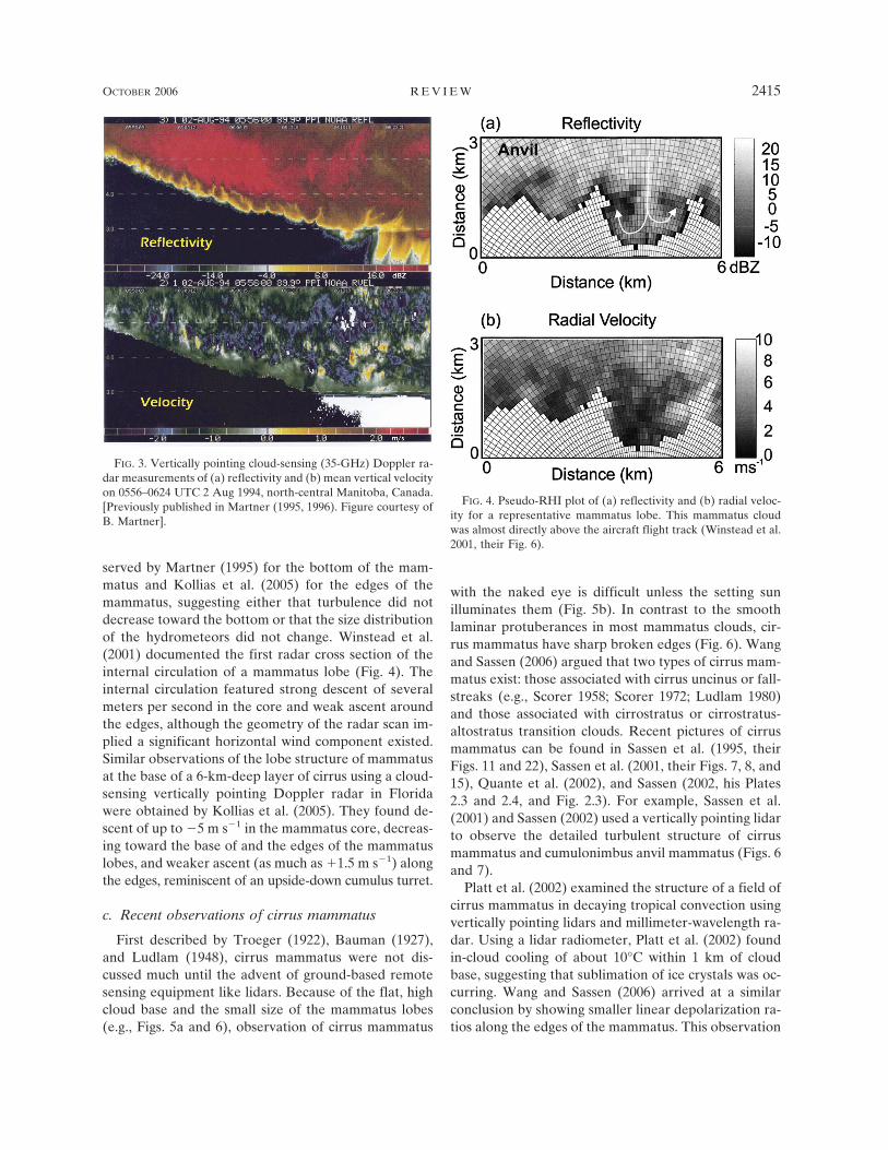
served by Martner (1995) for the bottom of the mam-matus and Kollias et al. (2005) for the edges of themammatus, suggesting either that turbulence did notdecrease toward the bottom or that the size distributionof the hydrometeors did not change. Winstead et al.(2001) documented the first radar cross section of theinternal circulation of a mammatus lobe (Fig. 4). Theinternal circulation featured strong descent of severalmeters per second in the core and weak ascent aroundthe edges, although the geometry of the radar scan im-plied a significant horizontal wind component existed.Similar observations of the lobe structure of mammatusat the base of a 6-km-deep layer of cirrus using a cloud-sensing vertically pointing Doppler radar in Floridawere obtained by Kollias et al. (2005). They found de-scent of up to �5 m s�1 in the mammatus core, decreas-ing toward the base of and the edges of the mammatuslobes, and weaker ascent (as much as �1.5 m s�1) alongthe edges, reminiscent of an upside-down cumulus turret.
c. Recent observations of cirrus mammatus
First described by Troeger (1922), Bauman (1927),and Ludlam (1948), cirrus mammatus were not dis-cussed much until the advent of ground-based remotesensing equipment like lidars. Because of the flat, highcloud base and the small size of the mammatus lobes(e.g., Figs. 5a and 6), observation of cirrus mammatus
with the naked eye is difficult unless the setting sunilluminates them (Fig. 5b). In contrast to the smoothlaminar protuberances in most mammatus clouds, cir-rus mammatus have sharp broken edges (Fig. 6). Wangand Sassen (2006) argued that two types of cirrus mam-matus exist: those associated with cirrus uncinus or fall-streaks (e.g., Scorer 1958; Scorer 1972; Ludlam 1980)and those associated with cirrostratus or cirrostratus-altostratus transition clouds. Recent pictures of cirrusmammatus can be found in Sassen et al. (1995, theirFigs. 11 and 22), Sassen et al. (2001, their Figs. 7, 8, and15), Quante et al. (2002), and Sassen (2002, his Plates2.3 and 2.4, and Fig. 2.3). For example, Sassen et al.(2001) and Sassen (2002) used a vertically pointing lidarto observe the detailed turbulent structure of cirrusmammatus and cumulonimbus anvil mammatus (Figs. 6and 7).
Platt et al. (2002) examined the structure of a field ofcirrus mammatus in decaying tropical convection usingvertically pointing lidars and millimeter-wavelength ra-dar. Using a lidar radiometer, Platt et al. (2002) foundin-cloud cooling of about 10°C within 1 km of cloudbase, suggesting that sublimation of ice crystals was oc-curring. Wang and Sassen (2006) arrived at a similarconclusion by showing smaller linear depolarization ra-tios along the edges of the mammatus. This observation
FIG. 3. Vertically pointing cloud-sensing (35-GHz) Doppler ra-dar measurements of (a) reflectivity and (b) mean vertical velocityon 0556–0624 UTC 2 Aug 1994, north-central Manitoba, Canada.[Previously published in Martner (1995, 1996). Figure courtesy ofB. Martner].
FIG. 4. Pseudo-RHI plot of (a) reflectivity and (b) radial veloc-ity for a representative mammatus lobe. This mammatus cloudwas almost directly above the aircraft flight track (Winstead et al.2001, their Fig. 6).
OCTOBER 2006 R E V I E W 2415
Fig 3 live 4/C

suggested smaller ice crystals along the edges, indicat-ing sublimation of the ice crystals in the dry air sur-rounding the protuberances.
Wang and Sassen (2006) identified 25 cases of cirrusmammatus over 9 yr using the high-cloud datasets fromthe Facility for Atmospheric Remote Sensing in SaltLake City, Utah (Sassen et al. 2001). The horizontalscale of the cirrus mammatus was 0.5–8.0 km, with avertical scale of 0.3–1.1 km below cloud base. Wang andSassen (2006) presented a case where both cirrus mam-matus and cumulonimbus (anvil) mammatus occurredwithin the same cloud (Fig. 6). They argued that thesmooth outline of cumulonimbus anvil mammatus was
a result of a hydrometeor fallout front (see section 3d),which was absent in the coarser-edged cirrus mamma-tus. Because both types occurred in similar large-scaleenvironments, Wang and Sassen (2006) argued that thelocal microphysical properties and downdraft velocitiesmust be responsible for the differences, a point re-turned to later in this paper.
d. Other observed cases
We now present two additional observations of mam-matus using radar. The first occurrence was collectedfrom the National Severe Storms Laboratory’s (NSSL)Cimarron dual-polarization Doppler radar (Zahrai and
FIG. 5. (a) Cloud polarization lidar returned-power displays of cirrus mammatus on 0100–0230 UTC 10 Sep 1994, Salt Lake City, UT; (b) upward-looking fish-eye lens photo of field ofcirrus mammatus on 0153 UTC 10 Sep 1994 (courtesy of K. Sassen).
2416 J O U R N A L O F T H E A T M O S P H E R I C S C I E N C E S VOLUME 63
Fig 5 live 4/C

Zrnic 1993). The second was collected with one of theUniversity of Oklahoma Doppler on Wheels (DOW2;Wurman et al. 1997) during the Intermountain Precipi-tation Experiment (IPEX; Schultz et al. 2002).
1) CENTRAL OKLAHOMA: 4 AUGUST 1992
On 4 August 1992, the Cimarron dual-polarizationradar captured the decaying stage of a mesoscale con-vective complex (MCC) that passed over central Okla-
homa (Gordon 1995; Gordon et al. 1995). The radarantenna was pointed vertically while the stratiform re-gion of the MCC passed overhead at 1128–1134 UTC.Time versus height reflectivity data (Fig. 8a) indicatedthe anvil occupied 5.5–7.0 km AGL, below which hungseveral perturbations (toward the right-hand side ofFig. 8a). The appearance of these perturbations on ra-dar suggests, although we have no visual confirmation,that these structures were mammatus.
FIG. 6. Cloud polarization lidar returned-power displays of an anvil case on 26 Aug 1998 where mammatus firstdeveloped at cirrus heights and later developed in a dense anvil. The expanded view of the cirrus and anvilmammatus illustrates the structural differences: cirrus mammatus are relatively narrow and are sharply outlined,whereas cumulonimbus anvil mammatus are smooth cauliflower-like protuberances (Wang and Sassen 2005, theirFig. 11).
OCTOBER 2006 R E V I E W 2417
To determine the size of these mammatus, the fea-tures were assumed to be advected by the mean windspeed at that level, and space–time conversion was ap-plied. Averaging the radial wind at constant rangesfrom the radar (i.e., Velocity Azimuth Display orVAD) produced a mean wind at 6 km AGL of 270° at15 m s�1. Consequently, the horizontal diameter of theperturbations was approximately 500 m. Although thevertical extent of the perturbations in radar reflectivityfactor was also about 500 m, the circulation, as esti-mated from the vertical-velocity measurements, was alittle deeper, about 1 km (Fig. 8b), consistent with pre-vious observations of deeper vertical circulations insidethe cloud associated with some mammatus (e.g., Mart-ner 1995; Winstead et al. 2001).
The corresponding velocity field (Fig. 8b) shows de-scent in areas of high reflectivity (greater than 7 dBZ)and ascent in areas of low reflectivity (less than 7 dBZ),consistent with previous studies (e.g., Martner 1995; Joet al. 2003; Wang and Sassen 2006). The descent rangedfrom �1 m s�1 to �4.5 m s�1, whereas the ascentreached �1 m s�1. The broad region of weak ascent(��l m s�1) below the mammatus (Fig. 8b) is indica-tive of the slow mesoscale ascent expected within theMCC (e.g., Houze et al. 1989). Immediately after col-lecting data with the radar pointing vertically, severalrange–height indicators (RHIs) were performed. TheseRHIs (not shown) confirm the structures observed dur-ing the vertically pointing mode.
Spectrum width (Fig. 8c) in the clouds was relativelylow (less than 2 m s�1), implying little turbulence. Inregions of small reflectivity, noise dominated signal,producing areas of large spectrum width (3–4 m s�1).The Norman sounding was released within 20–30 minof the mammatus event about 41 km southeast of theCimarron radar, but only reached about 580 hPa (notshown). The freezing level was at about 3.6 km MSL(3.1 km AGL) and a dry subcloud layer was present,both features typical of many mammatus events. Theband of low correlation coefficient as observed by theradar at 3.5 km AGL (Fig. 8d) indicated the meltinglayer (e.g., Zrnic et al. 1993; Straka et al. 2000). Thatcloud base was 5.0–5.5 km AGL (Fig. 8a) implies themammatus were above the freezing level and thus con-tained primarily ice-phase hydrometeors.
2) NORTHERN UTAH: 14–15 FEBRUARY 2000
This mammatus event occurred during IPEX, a fieldprogram designed to improve wintertime quantitativeprediction of precipitation over the IntermountainWest of the United States (Schultz et al. 2002). Knownas the Valentine’s Day windstorm, this cold front wasthe focus of IPEX’s fourth intensive observing period(IOP 4). The microscale structure and evolution of thefront in northern Utah was described by Schultz andTrapp (2003).
The mammatus were observed on the underside of aforward-sloping cloud in advance of a surface cold front
FIG. 7. Consecutive �10° elevation angle scans of returned energy collected by the polar-ization diversity lidar from the Facility for Atmospheric Remote Sensing (FARS) 0225:36–0228:38 UTC 26 Aug 1998 at a 1.0° s�1 scan rate, showing high-resolution slices throughturbulent cumulonimbus anvil mammatus (Sassen et al. 2001, their Fig. 8).
2418 J O U R N A L O F T H E A T M O S P H E R I C S C I E N C E S VOLUME 63

as it moved through northern Utah. The front was char-acterized by a temperature drop (8°C in 8 min), strongpressure rise (3 hPa in 30 min), and wind gusting over40 m s�1 (Schultz and Trapp 2003). An off-duty IPEXforecaster who was in Big Cottonwood Canyon in theWasatch Mountains reported virga and mammatusdraped from a cumulonimbus anvil ahead of the frontaround 0100 UTC 15 February (J. Ladue 2000, 2006,personal communication). He reported, “The mamma-tus was not as distinct as I see [during severe weather inthe central Great Plains of the United States. In thiscase, the mammatus consisted of] stringy virga exten-sions toward the ground without defined rounded sur-faces.” These observations of virga in association withmammatus are similar to those of Clarke (1962).
DOW2 was located 55 km north-northwest from La-due’s position. An RHI from 0104 UTC 15 February(Fig. 9a) shows the forward-sloping cloud with lobes ofhigher reflectivity underneath, about 1–2 km in hori-zontal scale.1 The corresponding radial-velocity fieldshows wind-speed minima at the bottoms of the largestlobes (Fig. 9b). Unfortunately, it was not obvious thatthe mammatus could be identified in plan position in-dicator (PPI) images from DOW2 so that the horizontaldistribution of the mammatus could be determined.
Mobile Cross-Chain Loran Atmospheric SoundingSystem (M-CLASS) soundings were released from thetwo NSSL mobile laboratories (Rust et al. 1990):NSSL4 was located at Oasis on the west side of theGreat Salt Lake and NSSL5 was located at Ogden–Hinckley Airport (OGD). The high vertical resolution(1 s or about 2–8 m) available with the M-CLASSsoundings provides detail about the environment inwhich the mammatus occurred. A sounding was re-leased from NSSL4 at 2347 UTC 14 February, 15 minbefore the surface front passed, through the likely lo-cation of the mammatus. The profile was characterizedby a dry-adiabatic layer below 680 hPa, an approxi-mately moist-adiabatic layer above 660 hPa, and a su-peradiabatic layer 246 m (20.9 hPa) deep below thecloud (Fig. 10a). The lapse rate was 12.6°C km�1 or adecrease in potential temperature of 0.8 K between680.7 and 659.8 hPa at temperatures of �2.0 to �5.1°C,respectively. Berg (1938, his Fig. 2) observed a supera-diabatic layer under mammatus, and Wagner (1948)argued that such a superadiabatic layer was importantto the formation of mammatus.
Nearly 90 min later, the sounding from NSSL5 at
1 This cross section of radar reflectivity (Fig. 9a) morphologi-cally resembles smoke plumes undergoing fumigation, wherestable air within the cloud overrides unstable air below (e.g., Pas-quill 1962, 181–182).
FIG. 8. Cimarron polarimetric radar data in vertically pointingmode, 1128:08–1134:40 UTC 4 Aug 1992. (a) Reflectivity (dBZ );(b) velocity (m s�1), (c) spectrum width (m s�1), and (d) correla-tion coefficient. Height ranges from 1 to 7 km AGL.
OCTOBER 2006 R E V I E W 2419
Fig 8 live 4/C

0115 UTC 15 February indicated cloud base was 2.97km MSL and �1.7°C (Fig. 10b). The cloud base fromthe sounding agreed with the height of the mammatusdetermined from the RHIs (3.0 km MSL or 1.7 kmAGL on Fig. 9a). This sounding also had a slight su-peradiabatic layer underneath cloud base (lapse rate of10.2°C km�1), 49 m thick (4.4 hPa) with a temperaturedecrease of 0.5°C and a potential temperature decreaseof only 0.02 K, indicating the deeper superadiabaticlayer observed earlier at NSSL4 had mostly stabilized.In the inset of Fig. 10b, several superadiabatic layers,separated by very stable layers, are seen below cloudbase; this pattern is likely indicative of highly turbulentlayers. The RHIs (e.g., Fig. 9a) and soundings (Fig. 10)indicate that the cloud deck was descending.
e. Summary of observations of mammatus
To summarize, the literature provides some informa-tion about the characteristics of mammatus clouds.Mammatus occur in association with a variety of cloudtypes: cumulonimbus, altocumulus, altostratus, stra-tocumulus, and cirrus. Mammatus have even been ob-served in contrails from jet aircraft and clouds of vol-canic ash. The horizontal dimensions of individualmammatus lobes range from 250 m to 8 km, with aver-age dimensions based on the available observations of1–3 km. Vertical extent below cloud base ranges from0.3 to 1.1 km, with most about 0.5 km. Whereas some
studies state the vertical and horizontal scales of motionwithin mammatus to be nearly equal, others have sug-gested or provided evidence that mammatus lobes maybe linked to vertical motions of much greater depth,perhaps even extending from the top of the cirrus out-flow anvil to the bottom cloud base of the mammatuslobes. Mammatus can appear in a local patch over asmall section of cumulonimbus anvil or be spread outover hundreds of km. The duration of a field of mam-matus can range from 15 min to as much a few hours.The life cycle of an individual mammatus lobe isshorter, however, on the order of 10 min.
Depending on the height of the anvil outflow [re-ported as low as 1.4 km by Hlad (1944) and as high as8 km by Wang and Sassen (2006)] and the ambientstratification, mammatus may be composed of mostlyliquid (e.g., Hlad 1944), mostly ice (e.g., Stith 1995; Kol-lias et al. 2005), or perhaps a combination of both.Mammatus in clouds of volcanic ash may challenge thenotion whether moist processes are even required insome situations. Several studies have noted a negativecorrelation between radar reflectivity factor and verti-cal motion in mammatus fields, indicating that the big-gest hydrometeors are in the downward-protrudinglobes. Descending air motion in the core of the mam-matus lobe is typically about �3 m s�1, surrounded byabout �1 m s�1 of rising motion.
These observations, however, do not offer a consis-
FIG. 9. RHIs from the Doppler on Wheels (DOW2) at 0104 UTC 15 Feb 2000 along the 117°azimuth: (a) radar reflectivity factor (dBZ ); (b) radial velocity (m s�1). Solid black line in (b)represents approximate outline of mammatus in (a).
2420 J O U R N A L O F T H E A T M O S P H E R I C S C I E N C E S VOLUME 63
Fig 9 live 4/C

tent picture of mammatus in some very significant ways.First, because mammatus have been observed in differ-ent environments and with different hydrometeors,multiple formation mechanisms may be acting. Second,sometimes an inversion is observed at or below cloud
base in association with or in proximity to the mamma-tus, whereas a subcloud superadiabatic layer is ob-served in other cases. Still other cases may possess both.Finally, aircraft penetrations through mammatus maybe smooth or turbulent. Thus, there remains much tolearn about the processes affecting mammatus. The re-mainder of this paper addresses these and other issues.
3. Mechanisms for formation
A variety of mechanisms have been proposed formammatus formation. Unfortunately, the serendipitousand limited observations of mammatus often lack thenecessary thermodynamic and microphysical data to as-sess their formation and evolution, let alone adequatelydescribe their structure. Consequently, rigorous evalu-ation of these mechanisms can be difficult. In this sec-tion, hypothesized mechanisms for mammatus are re-viewed and critically examined. Evidence supporting orrefuting these mechanisms, where available, is pre-sented.
Unless otherwise indicated, the theories discussed inthis section pertain primarily to cumulonimbus anvilmammatus (e.g., Fig. 1a). A cumulonimbus anvil formswhen the updraft of a cumulus cloud reaches its equi-librium level and spreads out. Because the recentlyrisen air in the anvil is not likely to have the sametemperature, moisture, and momentum as the sur-rounding environmental air, the base of the anvil isoften characterized by a strong vertical temperaturegradient (either an inversion or a superadiabatic layer),strong gradient in moisture, and strong wind shear. Inthis environment, cumulonimbus anvil mammatusform.
Some of the following mechanisms overlap. For ex-ample, several mechanisms destabilize the cloud base(e.g., the first three sections that follow). Such studiesargue that the creation of a statically unstable layer iscrucial for the formation of mammatus. Indeed, stati-cally unstable layers exist in several of the recentsoundings that sampled mammatus layers (e.g., Fig. 10of this paper; Fig. 8 of Stith 1995; Fig. 8 of Winstead etal. 2001). Despite some overlap, the following processesare retained as separate discussions, in part becauseprevious studies have presented them separately.
a. Large-scale anvil subsidence
Large-scale anvil subsidence was first proposed byWagner (1948), Ludlam and Scorer (1953), and Scorer(1958, 1972). This mechanism posits that the dynamicsof the thunderstorm anvil provide a large-scale envi-ronment favorable for the initiation of mammatus.
FIG. 10. Skew T–log p plot of observed soundings at (a) NSSL42347 UTC 14 Feb 2000 and (b) NSSL5 0115 UTC 15 Feb 2000.Temperature (°C, solid lines), dewpoint temperature (°C, dashedlines), and winds (one pennant, full barb, and half barb denote 25,5, and 2.5 m s�1, respectively). Insets are expanded areas ofsoundings showing details of the cloud base and superadiabaticlapse rates.
OCTOBER 2006 R E V I E W 2421

When cloudy anvil air flows horizontally over a layer ofunsaturated air, a vertical moisture gradient exists.Sinking of the cloud deck and the unsaturated air belowoccurs, perhaps because of the compensating down-drafts associated with the main thunderstorm updraft(e.g., Ludlam and Scorer 1953), the descent of hydrom-eteors through the cloud (e.g., Wagner 1948; Martner1995; Platt et al. 2002), or the cloud deck havingreached its level of neutral buoyancy. [Descending an-vils have been described by Lilly (1988), Martner(1995), Platt et al. (2002), Knight et al. (2004), andWang and Sassen (2006).] As the air sinks, the cloudylayer warms at the moist-adiabatic lapse rate, while theunsaturated air below warms at the dry-adiabatic lapserate. The difference in lapse rates results in greaterwarming in the subcloud air than in the cloudy air anda consequent steepening of the local lapse rate at thecloudy–clear-air interface. Convective overturning atthe base of the anvil may then result, in which the satu-rated air falls in drop-like formations resembling mam-matus lobes (e.g., Ludlam and Scorer 1953).
Observational support for this mechanism comesfrom Imai (1957). Using a 3.2-cm radar in Japan, Imai(1957) documented a thunderstorm with a subsidinganvil and a horizontal cellular pattern of mammatusclouds. Reflectivity images (his Fig. 11) show an anvilunderside with mammatus-like features remarkablysimilar to that presented more recently (e.g., Martner1995; Winstead et al. 2001; section 2d of the presentpaper). The anvil descended from 11 to 8 km overabout 3 h. The anvil descent speed of 0.4 m s�1 wassimilar to the terminal velocity for frozen 0.7-mm iceneedles, suggesting some validity to Wagner’s (1948)hypothesis. (The size and shape of the hydrometeors atthe top of the anvil cannot be assumed to be the sameas those at the bottom, however.)
Although a plausible mechanism, there are severalproblems with large-scale subsidence as the sole mecha-nism for mammatus production. First, some previousobservations of mammatus do not show subsidence ofthe cloud base. For example, the 4 August 1992 eventdiscussed in section 2d(l) exhibited weak ascent in theregion below the mammatus, which is consistent withthe conceptual model of mesoscale ascent above themelting level within mesoscale convective systems (e.g.,Houze et al. 1989). Second, care must be taken in in-terpreting some mammatus cases where a descendinganvil is believed to occur. Specifically, if a mammatusevent is observed on a sloped undersurface of a clouddeck from a time series of radar reflectivity from avertically pointing radar [e.g., Martner 1995; Kollias etal. 2005; section 2d(l) of the present paper], then deter-
mining whether a horizontal cloud base descended overtime or whether a sloped cloud base [e.g., Warner 1973;section 2d(2) of the present paper] translated over theradar cannot be determined without additional infor-mation. Finally, separating the fall speed of the hy-drometeors from the vertical air motions is not easy,thereby preventing a clean interpretation of the mean-ing of these radar-derived vertical motions. In any case,the data needed to adequately test the hypothesis thatanvil subsidence produces an instability responsible formammatus formation, even for a specific case, is lack-ing.
b. Subcloud evaporation/sublimation
Subcloud evaporation or sublimation is the mostcommonly cited mechanism to explain mammatus for-mation, originating from Troeger (1922), Letzmann(1930), Hlad (1944), Ludlam (1948), and Scorer (1958).Ice crystals, snow aggregates, liquid water droplets, ormixtures of these hydrometeors fall from cloud baseinto subsaturated air and begin to sublime and evapo-rate. Cooling just below cloud base provides the impe-tus for saturated descent in mammatus-like lobes. Thisprocess, if it occurs over a large portion of the cloudbase, can result in a lowering of the anvil cloud baseover time (see section 3a). At the point where the de-scending lobe is no longer buoyant with respect to theambient air, the lobe, or edges of the lobe, may returnupward and create a rounded shape to the mammatuscloud.
Three pieces of evidence support subcloud evapora-tion/sublimation as a viable hypothesis for mammatusformation. First, several radar-based studies imply thatthe decreasing particle size and the narrowing size dis-tribution near the bottom of radar-observed mammatuslobes indicate evaporation/sublimation is occurringwithin the mammatus lobes (e.g., Martner 1995; Kolliaset al. 2005; Wang and Sassen 2006). Aircraft penetra-tions by Heymsfield (1986) also found that evaporationwas occurring underneath a cumulonimbus anvil in aregion where mammatus was forming.
Second, Letzmann (1930) hypothesized that the cool-ing due to evaporation of water droplets below cloudbase, in conjunction with the warming due to descent ofthe cumulonimbus anvil, may be responsible for thecommonly observed inversion at the base of the mam-matus (e.g., Clayton 1911; Hartmann 1920; Schneider1920).
Finally, the prevalence of a subcloud dry layer inmany soundings near mammatus (e.g., Clayton 1911;Schneider 1920; Berg 1938; Hlad 1944; Wagner 1948;Winstead et al. 2001; Wang and Sassen 2006; Fig. 10a ofthe present paper; K. M. Kanak and J. M. Straka, un-
2422 J O U R N A L O F T H E A T M O S P H E R I C S C I E N C E S VOLUME 63

published research results) suggests evaporation nearcloud base is likely. For example, soundings throughmammatus sometimes show a superadiabatic layer un-derneath the mammatus (e.g., Fig. 2 in Berg 1938; Fig.10 in the present paper). Superadiabatic layers in thefree atmosphere can result from strong evaporation,cooling the air just below cloud base more quickly thanturbulence can eliminate the instability. Hodge (1956)noted similar superadiabatic layers at the tops of cloudswhere evaporative cooling was occurring. Such supera-diabatic layers are more common than perhaps previ-ously recognized. For example, Slonaker et al. (1996)constructed a climatology of superadiabatic layers atleast 50 hPa above the surface in 73 497 soundings fromthe U.S. Midwest for 1983–87. They found 60% of thesoundings had at least one superadiabatic layer, al-though most of these layers were only a few degrees inmagnitude and existed over a shallow depth. Slonakeret al. (1996, their Table 9) identified where these layersoccurred relative to clouds and found that 7.5% of thelayers with superadiabatic lapse rates existed belowcloud base. Precipitation falling onto temperature sen-sors approaching clouds may also explain some sub-cloud superadiabatic lapse rates. Section 4.3.2 of theFederal Meteorological Handbook 3 (http://www.ofcm.gov/fmh3/text/chapter4.htm) states that superadiabaticlayers “shall be categorized as valid if the decrease inpotential temperature in the layer does not exceed 1.0K. If the lapse rate exceeds this value, the temperaturedata in the layer are not realistic. Data shall be deletedif the potential temperature decreases by more than 1.0K over any stratum or interval. If the temperature re-verts back to the original trend, the data should becarefully examined to determine if the shift is real orerroneous. If the observer suspects it is erroneous thosedata shall be flagged as doubtful.” In both cases in Fig.10, the superadiabatic layers are valid by these criteria.
Despite strong evidence in support of evaporativecooling as a mechanism for some mammatus, there arethree reasons why it may not be operating in all cases.First, the presence of evaporation does not always pro-duce mammatus (Heymsfield 1986). Second, Stith(1995) argued that, because the temperature inside amammatus lobe was 0.7°C higher than that outside,evaporative cooling could not be responsible, at least atthe mature stage of this one mammatus lobe. Expectingthe inside of a mammatus lobe to be warmer or coolerdoes not appear to be a rigorous test for the evapora-tive cooling hypothesis, however. For example, initialinhomogeneities in evaporative cooling at cloud basemay manifest themselves as the early stages of mam-matus, drawing the cloudy air downward underneaththe maxima of cooling. Once the mammatus lobes ma-
ture and become large, evaporative cooling becomesgreatest at the edge of the mammatus, not inside themammatus. Thus, in the mature stage, we speculate thatmoist-adiabatic descent and warming may be occurringwithin the mammatus lobe, whereas evaporative cool-ing may be occurring along the edges where descent(and adiabatic warming) is less, also.
Third, Martner (1995), Winstead et al. (2001), andsection 2d(l) of the present paper documented reflec-tivity and velocity structures extending from the mam-matus bases up to 1 km or so into the convective cloud.That the vertical velocities at heights above the mam-matus bases were greater than those within the mam-matus lobes suggests that evaporation at cloud base wasnot the main driving force for these downward motions.On the other hand, Platt et al. (2002) presented lidardata of tropical cirrus clouds with mammatus. Calcula-tions of cooling rates based on their data yielded cool-ing to at least 1 km above cloud base. Thus, evaporativecooling may act on scales much deeper than just at thecloudy–clear-air interface.
c. Melting
Like sublimation and evaporation, cooling due tomelting near cloud base may be responsible for mam-matus formation. Knight et al. (2004) found that thedescent of an anvil below the freezing level appeared tobe associated with the formation of mammatus. Theyproposed a mechanism, first suggested by Findeisen(1940), that explains the formation of convective cloudsbeneath and within nimbostratus generated through theagency of the melting level. As falling precipitationmelts, release of latent heat deepens the isothermallayer at 0°C (e.g., Findeisen 1940; Stewart 1984; Bosartand Sanders 1991; Kain et al. 2000), steepening thelapse rate underneath. Eventually, saturation is reachedin the layer below the melting level and convection canresult. If cloud base were to occur near the freezinglevel, the formation of mammatus is possible.
This hypothesis is supported by two other observa-tions. First, like Knight et al. (2004), Imai (1957, his Fig.15) showed the close association between mammatusand the location of the radar bright band where meltingoccurs (e.g., Byers and Coons 1947). Second, Table 1shows that five of the eight (63%) noncirrus mammatusevents in the literature for which temperatures wereavailable occurred at temperatures within a few degreesof freezing. This observation would appear to be ratherstrong evidence for the viability of this mechanism. Onthe other hand, not all mammatus, including cirrusmammatus, occur near the melting layer [e.g., section2d(1)], thus melting may not be the sole mechanism bywhich all mammatus form.
OCTOBER 2006 R E V I E W 2423

d. Local-scale hydrometeor fallout
Local inhomogeneities in hydrometeor mass can leadto inhomogeneities in vertical air motion, which canlead to inhomogeneities in the descent of hydromete-ors. When coupled with the hydrodynamic effects offrictional drag around the edge of such a precipitationshaft, the scale of the downdraft expands, and mamma-tus-like perturbations may result (Scorer 1958). Al-though anvils are observed to subside possibly due tothis effect (section 3a), this fallout mechanism does notrequire thermodynamic instability, which is essential tosome other proposed mechanisms for mammatus.
As hydrometeors descend in lobes, sublimation andevaporation occur, eventually limiting the mass of hy-drometeors causing the descent, which may limit thedepth of descent. Once the mammatus lobe forms, italso forms a baroclinic zone owing to temperature gra-dients from the sublimation/evaporation and mass gra-dients from the presence of hydrometeors. Around thelobe, shear and curvature vorticity are present. The cur-vature vorticity would lead to the upward motionsaround the lobes, providing the observed ascending re-turn flow (e.g., Fig. 4).
Supporting evidence for this mechanism comes fromthree sources. First, some studies have shown thatvariations of reflectivity in mammatus are negativelycorrelated with Doppler vertical velocity variations(e.g., Martner 1995; Jo et al. 2003; Wang and Sassen2006). Thus, the descent in mammatus would appear tobe strongly related to the fall speeds of the hydromete-ors. In addition, the magnitudes of the vertical motionsat the bottom of the mammatus are often comparableto the terminal velocity of the constituent hydromete-ors (e.g., Stith 1995). Other evidence suggests that acloud layer may fall faster than its constituent hydro-meteors (Clark and List 1971).
Second, Heymsfield (1986) used in situ measure-ments of a Colorado thunderstorm anvil and found thataggregation of hydrometeors was a likely processwithin anvils and that the maximum particle size shouldincrease with distance downwind of the updraft core.For storms in which this is true, mammatus locatedadjacent or very near the updraft core may be made upof generally smaller particles. Heymsfield (1986) addedthat falling aggregates lower the anvil base and modifythe relative humidity below cloud base. He also ob-served that the particle spectrum broadened towardcloud base where mammatus existed. The broad spec-trum at cloud base may allow differential falloutspeeds, which might be conducive to forming lobestructures through the mechanism described above.
Third, Stith (1995) found a warm anomaly inside de-
scending mammatus lobes relative to the ambient air.Thus, if the air inside the mammatus lobe is not nega-tively buoyant due to temperature, the air must benegatively buoyant due to the mass of hydrometeors orthrough nonhydrostatic effects in order to be respon-sible for the observed descending motion inside mam-matus lobes.
A weakness in the hydrometeor fallout mechanism isthat vertical motions inside the mammatus lobes can belarger than the fall speeds of hydrometeors, especiallywhen those are small ice crystals with slow fall speeds(e.g., Martner 1995; Jo et al. 2003). Thus, the size orcomposition (ice/water) of the hydrometeors cannot beprimarily responsible for the mammatus, and someother dynamic effect must be occurring. Furthermore, iffallout were a feasible mechanism, all clouds mighthave mammatus.
e. Cloud-base detrainment instability
Emanuel (1981; 1994, 220–221) presented a mixingtheory to explain mammatus called cloud-base detrain-ment instability (CDI). CDI is analogous to cloud-topentrainment instability (e.g., Deardorff 1980; Randall1980), but applied at the anvil cloud base. CDI is similarto, but differs from, subcloud evaporation/sublimation(section 3b) and hydrometeor fallout (section 3d) in thefollowing manner. In subcloud evaporation/sublimationand hydrometeor fallout, condensed water is intro-duced to the dry subcloud air by precipitation (Ludlamand Scorer 1953), whereas, for CDI, condensed water isintroduced to the dry subcloud air by mixing (Emanuel1981). CDI typically occurs under differential horizon-tal advection of cloudy air over clear air, as in the caseof cumulonimbus anvils.
The condition for CDI is that the liquid-water staticenergy of the subcloud air be higher than that of thecloudy air. Consider a cloudy–clear-air interface withthis stratification. If a parcel of cloudy air is mixeddown into the subcloud air and all the liquid water isevaporated, the resulting air parcel becomes negativelybuoyant and accelerates downward. Instability is opti-mized by a moderate level of relative humidity in thesubcloud layer. If the subcloud environment is toomoist, evaporation takes place too slowly to overcomeadiabatic warming; if it is too dry, evaporative coolingof the hydrometeors quickly occurs and penetration ofthe thermal will not be very deep. Fernandez (1982)suggested that CDI may be responsible for local-scaleinitiation of downdrafts in tropical squall lines, al-though the scale of the downdrafts would need to behundreds of meters, smaller than the typical scale ofmammatus (e.g., Table 1) in order to be effective.Emanuel (1981) further hypothesized that CDI could
2424 J O U R N A L O F T H E A T M O S P H E R I C S C I E N C E S VOLUME 63

proceed rapidly enough in cirrus clouds to generatemammatus-like perturbations.
CDI implies a steep lapse rate under the cloud and aninversion at cloud base (Emanuel 1981) as observed innumerous cases of mammatus (e.g., Clayton 1911; Hart-mann 1920; Schneider 1920; our Fig. 10a). On the otherhand, CDI does not explain why mammatus only ap-pears locally on some regions of the anvil and not overthe entire anvil region (e.g., Fig. 1a). CDI also fails toexplain how the mixing initiates, which is required toobtain the instability. Perhaps a second mechanism, likeKelvin–Helmholtz instability, is required to mix the airbefore CDI can ensue. According to K. Emanuel (2005,personal communication), CDI is almost linear, and soits release is expected to occur spontaneously.
f. Radiative effects
Mammatus are observed most frequently in the af-ternoon and early evening (e.g., Osthoff 1906; Troeger1922), perhaps due to adequate illumination of the un-derside of cumulonimbus clouds that can only occurwhen the sun angle is low. Although most cumulonim-bus occur during this time because of daytime heating,the prevalence of mammatus late in the day may alsosuggest that radiative processes may play some role inmammatus formation. For example, after the initial tur-bulence in the anvil outflow is largely dissipated, a ra-diative–convective mixed layer may form (Lilly 1988).The cloud top is almost certain to be radiatively warmerthan its upper environment (i.e., space), whereas thebottom is probably cooler than its radiative environ-ment (i.e., ground surface). Under these conditions, theanvil cloud may act somewhat like a stratocumuluslayer, except convection is driven on both top and bot-tom. Plank et al. (1955) also suggested longwave radia-tion from cloud top might destabilize the cloud layerand lead to instabilities at cloud top. If so, radiativeprocesses could result in deep vertical motions withinthe anvil. In this scenario, the mammatus at cloud basemay be the visible manifestation of the convection pen-etrating downward from the top of the cloud layer.Based on radiative-cooling estimates of Ackerman etal. (1988), Lilly (1988) estimated a characteristic verti-cal velocity scale for this downward convection of about2 m s�1, small compared to the storm updraft, but quitesimilar to the vertical motions within mammatus lobes(Table 1).
Radiatively cooled thermals expand as they descend.Similarity theory shows that the diameter of such ther-mals expands at a rate of about 50% of the cloud depth(e.g., Rogers and Yau 1989, 54–55). Thus, a mammatuslobe diameter of 1–3 km corresponds to a depth of
penetration of 2–6 km, which is a typical depth of thecloud anvil.
How does the rate of radiational cooling compare tothat from evaporation/sublimation? Consider a hypoth-esis whereby mammatus is driven by the evaporation of1 g kg�1 of liquid precipitation. Complete evaporationwould correspond to 2.5 K of cooling, as calculatedfrom L�w/cp, where L� is the latent heat of vaporization,w is the liquid water content, and cp is the specific heatof air. Of course, evaporation is not instantaneous. As-suming the precipitate falls order 1 m s�1 into a drylayer with 60% relative humidity, evaporation is order10% km�1 (Pruppacher and Klett 1997, p. 543). Inother words, the evaporative cooling rate is order 1 Kh�1. For snow, cooling should be of a similar order ofmagnitude. In contrast, cloud-top radiative coolingcould be well in excess of 5 K h�1 (e.g., Garrett et al.2005) and is in the right place (cloud top, not cloudbase) to stimulate the observed deep penetrative down-drafts. Thus radiative cooling can have similar, if notgreater, potential for forcing negatively buoyant ther-mals.
Furthermore, observations by Garrett et al. (2005)showed that cloud radiative heating in optically thick,tropical cloud anvils can be concentrated within 100 mof cloud base, because terrestrial longwave radiationcannot penetrate deep into optically thick clouds. Con-sequently, a layer near the lowest part of the cloudbecomes destabilized (Garrett et al. 2006). This type ofradiative destabilization is more consistent with obser-vations that show descending lobes originating withinthe cloud near cloud base [e.g., Martner 1995; Winsteadet al. 2001; section 2d(1) of the present paper]. Thenecessary precondition for this destabilization to occuris that the cloud is sufficiently optically dense (eithersmall particles or large water contents) to be nearlyopaque to longwave radiation in the lowest 100 m or so.Specifically, to create longwave radiative contrasts, theabsorption optical depth should be greater than unity,in which case the visible optical depth is greater thanabout 2, sufficient to nearly obscure the direct radiationbeam from sources behind the cloud. Because clouds ofvolcanic ash are moist and optically thick (Fig. 1b, sec-tion 4g), this condition is likely satisfied for these situ-ations. This argument raises the question: are mamma-tus ever seen extending from optically thin clouds? Ifso, then alternative mechanisms, such as evaporation,are required to produce the mammatus because long-wave radiation is likely not playing an important role.Indeed, Fig. 2d shows blue sky between the mammatuslobes indicating that mammatus can occur in the ab-sence of thick clouds. Two caveats to the above obser-vation need to be made. First, what the thickness of the
OCTOBER 2006 R E V I E W 2425

cloud was at the time any hypothesized downward pen-etrating thermal was initiated through radiative coolingis unknown. Second, the cloud may be thinner aroundthe mammatus because of the descent of cloudy airfrom around the downward-penetrating lobe and therecirculation of drier air upward.
g. Gravity waves
Gravity waves are ubiquitous in the atmosphere. Assuch, it is perhaps not surprising that they have beenimplicated as mechanisms for mammatus formation.Gravity waves excited as thunderstorm updrafts im-pinge on the tropopause can result in wave phenomenaat upper levels (e.g., Hung et al. 1979; Balachandran1980; Fovell et al. 1992; Alexander et al. 1995; Beres etal. 2002), or gravity waves can result from the imposi-tion of thermal forcing in the midtroposphere (e.g.,Yang and Houze 1995; Pandya and Durran 1996).Clarke (1962; discussed in section 2b), Gossard andSweezy (1974), and Winstead et al. (2001) observedwavelike patterns in cases associated with mammatusand attributed them to gravity waves.
Similar to the surface pressure oscillations observedby Clarke (1962), Gossard and Sweezy (1974) observedwaves with surface observations and a radar sounder atSan Diego, California. Waves were evident from thesounder at 500–750 m AGL, with a spectacular displayof mammatus at middle levels (2–7 km) throughout theobservation period. These waves were associated withsignificant wind shear at 1–4 km. The shear was strong-est within and above a nearly dry-adiabatic layer, wherethe directional shear was nearly 180°. A nearly adia-batic layer existed, across which the significant speedshear was observed, as was the case for Clarke (1962).Gossard and Sweezy (1974) calculated a Richardsonnumber less than 0.25 at 2 km AGL. Although Kelvin–Helmholtz instability may have been being released,Gossard and Sweezy (1974) interpreted their results inthe context of gravity waves. Proximity soundingsshowed conditional instability above the shear layer sothat shear-induced waves could have resulted in therelease of conditional instability that could then havebeen manifest as mammatus clouds. The presence ofthe shear and a similar sounding do not always implythe presence of mammatus, however (e.g., Gossard andSweezy 1974; Gossard 1975).
Winstead et al. (2001) identified wave patterns in amammatus-bearing cloud with 4–7-km wavelength andvertical velocity minima of �10 m s�1. Vertical velocityperturbations of similar scale were also found in theclear air below the anvil, indicative of downward-propagating waves. The lines of mammatus were ap-proximately oriented perpendicular to the mean wind
direction,2 and the sounding through the mammatuspossessed exceptionally strong shear across the cloudbase (Winstead et al. 2001, their Fig. 7).
Yang and Houze (1995) and Pandya and Durran(1996) used two-dimensional idealized simulations ofconvective systems with 1-km horizontal resolution toshow gravity waves on the underside of the trailingstratiform regions. These gravity waves modulated thecloud base in a manner that looked like mammatus,although clearly of much larger scale. Ooyama’s (2001)two-dimensional idealized simulation of a convectiveupdraft impinging on a stable layer excited gravitywaves in a spreading canopy. He described the horizon-tal rotation of cloud at the outer edge of the spreadingcanopy as mammatus-like protrusions, although theremay be some debate about the exact nature of theseprotrusions. Indeed, still photos (Fig. 1a) and time-lapse movies (D. Dowell 2005, personal communica-tion) of cumulonimbus sometimes show mammatusforming at the leading edge of the spreading anvil.
As for some previous mechanisms (e.g., sections 3e,f), one argument that works against gravity waves beingresponsible for mammatus is why mammatus would oc-cur on a localized section of cumulonimbus anvil whengravity waves would be traveling radially away from theupdraft over a larger horizontal distance. Furthermore,the scale and lobed shape of the mammatus do notmatch the pattern of vertical motions in a gravity wave.For example, Kollias et al. (2005, their Fig. 1) showedgravity waves within the depth of the cloud, but theywere at a much different scale than that of the mam-matus. Gravity waves may organize mammatus lobes,as perhaps seen in Fig. 1a, but likely do not generate themammatus themselves.
h. Kelvin–Helmholtz instability
Kelvin–Helmholtz instability can occur within a sta-bly stratified fluid with strong vertical wind shear (e.g.,Chandrasekhar 1961, his chapter 11). If the shear acrossthe interface exceeds a critical Richardson number rela-tive to the stratification, then distinctive Kelvin–Helmholtz waves can form. Although early researchersrecognized that mammatus often occurred in conjunc-tion with strong wind shear (e.g., Wegener 1909; Hart-mann 1920; Troeger 1922), Berg (1938) was the first to
2 There is a discrepancy between the text on p. 161 and thefigure caption of Fig. 3 in Winstead et al. (2001) (N. Winstead2005, personal communication). The text should read, “Thedashed lines in Fig. 3 indicate an orientation approximately per-pendicular to the mean wind direction, though other orientationsmay also be envisioned.”
2426 J O U R N A L O F T H E A T M O S P H E R I C S C I E N C E S VOLUME 63
suggest that mammatus may be a result of the release ofKelvin–Helmholtz instability.
Strong evidence for an association between the re-lease of Kelvin–Helmholtz instability and mammatusclouds comes from radar observations of a tropical cu-mulonimbus anvil by Petre and Verlinde (2004). Theyobserved Kelvin–Helmholtz waves that descended tocloud base, occurring at the same time as the formationof mammatus clouds observed by Jo et al. (2003) andKollias et al. (2005). Therefore, in at least one case,wave-induced vertical motions inside clouds appear tobe associated with mammatus clouds, perhaps the mostconvincing evidence published to date.
Despite this evidence for the association of mamma-tus with Kelvin–Helmholtz instability, several questionsarise. First, why don’t mammatus look more like theorganized rows of Kelvin–Helmholtz billows? Second,why isn’t the nonlinear wave-breaking stage (Fig. 2g)apparent more frequently? Perhaps such wave breakingis not visible because the billows are in-cloud and notvisible. In the case presented in Fig. 2g, the mammatuscould have been formed due to other mechanisms, butbegan to break once the mammatus extended into aregion of stronger shear. Whether the shear resulted inthe release of Kelvin–Helmholtz instability that causedthe mammatus or the mammatus revealed the existenceof the shear layer is not known for this case. Finally,Kelvin–Helmholtz instability requires a statically stableatmosphere, so mammatus forming in regions of staticinstability are not likely to be due to Kelvin–Helmholtzinstability.
Finally, although some aircraft penetrations throughmammatus have been turbulent (e.g., Hlad 1944), oth-ers have not been (e.g., Stith 1995). Doppler spectrumwidth measurements by Kollias et al. (2005) indicatethat the mammatus is the most turbulent region of thecloud, whereas Winstead et al. (2001) found that themammatus was not very turbulent at all, although theenvironment was quite turbulent. It may be that ifKelvin–Helmholtz instability were responsible formammatus, the billows may only be developing and,thus, not have become turbulent with breaking waves.Consequently, care must be taken in attributingKelvin–Helmholtz instability to mammatus.
i. Rayleigh–Taylor instability
Rayleigh–Taylor instability was proposed as amechanism for mammatus by Agee (1975). This insta-bility, as classically defined (e.g., Rayleigh 1883; Taylor1950), occurs on the interface between two incompress-ible fluids when denser fluid lies overtop a less-densefluid (e.g., Chandrasekhar 1961, his chapter 10; Sharp1984). Because Rayleigh–Taylor instability is an inter-
facial instability, it cannot be applied to continuouslystratified atmospheric flows.
For the sake of argument, however, if Rayleigh–Taylor instability were applicable to clouds, the cloudcould be considered one fluid and the subsaturated airbelow cloud the other fluid. Simple calculations revealthe magnitude of the effect that would be required toproduce Rayleigh–Taylor instability. Assuming densityincreases with height, the necessary criterion for Ray-leigh–Taylor instability, a subsaturated atmospherewould have to have a lapse rate exceeding 32°C km�1,the autoconvective lapse rate (Glickman 2000, p. 64).Such a lapse rate is hard to imagine in the free atmo-sphere. Alternatively, density may increase with heightbecause of precipitation loading. For a saturated atmo-sphere with a lapse rate of 7°C km�1, the hydrometeormixing ratio (liquid and/or ice) would need to increaseat a rate of �100 g kg�1 km�1. For a 10-m-deep layer atcloud base, the hydrometeor mixing ratio need increaseonly about 1 g kg�1. Such a change in the hydrometeormixing ratio is possible across a hydrometeor front, sug-gesting that Rayleigh–Taylor instability might be actingalong the cloudy–clear-air interface, or across the inter-face of an ash cloud (see section 4g).
Any fluid that has density increasing with height,however, will be statically unstable (i.e., N2 � 0, whereN is the Brunt–Väisälä frequency). Thus, even if aninterfacial instability (and an interface) exists, buoyantinstability of the entire layer exists. Indeed, Rayleigh(1883) showed that the interfacial instability is simplythe limiting case of the layer depth going to zero (i.e.,an infinitely thin transition between two fluids). Asnoted earlier, to invoke an explanation requiring a dis-continuous fluid seems artificial in the context ofclouds. Therefore, mammatus formation does not seemlikely to be associated with Rayleigh–Taylor instability.
j. Rayleigh–Bénard-like convection and theSchaefer and Day mechanism
Mammatus have been referred to as “upside-downconvection” with sinking cold-air plumes instead of ris-ing warm-air plumes (e.g., Schlatter 1985), and has beenhypothesized to occur because of cellular convection(e.g., Ludlam 1948; Schaefer and Day 1981). Specifi-cally, Rayleigh–Bénard convection arises from the cre-ation of static instability through the heating of thelower boundary (or cooling of an upper boundary) ofan initially quiescent homogeneous fluid. In the case ofmammatus, however, the geometry is reversed with thelower boundary (cloud base) cooled by differentialadiabatic cooling due to vertical motion (section 3a),evaporation (section 3b), or mixing (section 3e). Be-cause this cooling is not occurring on a flat boundary,
OCTOBER 2006 R E V I E W 2427

Rayleigh–Bénard convection cannot be occurring in thestrictest sense, so we say the convection is Rayleigh–Bénard-like convection and refer to the more generalterm cellular convection.
Schaefer and Day (1981, p. 136) proposed a mecha-nism for mammatus in which Rayleigh–Bénard-likeconvection plays a central role. They argue:
In a short time the cloudy air reaches the sametemperature as the cloud-free air because of radiationand mixing. Because some of the cloudy air above isnow at the same temperature, it is unstable because ofthe aggregate weight of the cloud droplets. However,because it has no nearby boundaries, the falling airdivides into a polygonal array of downward-movingparcels of air called Bénard Cells. Because suchdownward movement must have upward compensa-tion of cloud-free air, the undersurface of the cloudsoon becomes a mass of pendules.
Whether the cloudy air and cloud-free air reach ther-mal equilibrium is debatable (e.g., Stith 1995). Cer-tainly, soundings where mammatus are present (e.g.,Fig. 10) can show strong temperature gradients acrosscloud base. Taken as a whole, Schaefer and Day’s(1981) proposed mechanism seems weak and unsub-stantiated.
4. Discussion
In sections 2 and 3, we discussed previous observa-tions of mammatus and proposed mechanisms for theirformation, respectively. In this section, other questionsconcerning the composition, character, size, and orga-nization of mammatus are discussed.
a. Are mammatus composed of ice crystals orliquid water droplets?
Scorer (1958) argued that mammatus are more likelyto be seen in snow showers because the reduction invisibility is greater than rain, similar to the argumentsabout whether virga was associated with melting snowor evaporating rain (i.e., Fraser and Bohren 1992, 1993;Sassen and Krueger 1993). Table 1 shows the tempera-ture at which mammatus was observed for eight eventswhere temperature could be determined. Except forone event [case I in Hlad (1944), where the temperaturewas about �15°C], temperatures were all very near orbelow freezing (�1° to �25°C), suggesting that mam-matus is often associated with at least some ice. Cer-tainly, cirrus mammatus (section 2c) is composed en-tirely of ice crystals.
Microphysical observations inside mammatus, how-ever, are inconsistent. Aircraft penetrations of mamma-
tus in Hlad’s (1944) case III showed that rain was heavyinside the mammatus. In contrast, Stith (1995) foundaggregated ice particles with insignificant liquid wateramounts inside mammatus. The mammatus in Mart-ner’s (1995) and our cases (e.g., Figs. 8 and 9a) occurredabove the radar bright band, also suggesting ice was acomponent. Clough and Franks (1991) showed that thesublimation of snow and falling ice hydrometeors oc-curs more rapidly and over a shorter distance than liq-uid water, suggesting some preference for frozen hy-drometeors in mammatus. Thus, mammatus are likelyto be mostly ice, although some may occur with liquidwater.
In the case of mammatus in jet contrails, liquid watercontents are very low (about 1–10 mg m�3), so it isunlikely that precipitation-sized particles are involved.Observations of hydrometeors in contrails confirm rela-tively small particle sizes (1–10 �m; Schröder et al.2000), much smaller than precipitation-sized hydrom-eteors. Thus, mechanisms that require precipitation canlikely be eliminated from consideration for mammatusin contrails.
b. Why are mammatus generally smooth andlaminar?
Regardless of whether mammatus are composed ofice crystals or liquid water, why the edges of the mam-matus usually have smooth laminar shapes remains anintriguing question. Emanuel (1981) attributed thesmoothness of mammatus to mammatus lobes havingundershot their equilibrium levels. At the leading edgeof such lobes, a layer of strong static stability would beobserved that might account for their laminar appear-ance. Stith (1995) observed a warm anomaly inside themammatus of 0.7°C, suggesting that the strong staticstability at their leading edge helps maintain the integ-rity of the individual lobes in agreement with Eman-uel’s (1981) hypothesis.
Second, Ludlam (1980) hypothesized that, with a uni-formly sized hydrometeor distribution, the precipita-tion falls at the same rate as the downdraft and holdstogether. Stith (1995) measured the fall speed of iceparticles in mammatus being similar to the downdraft,supporting this hypothesis. Further support comes fromthe observation that the descent associated with mam-matus is rarely as large as the fall speed of rain drops(�5 m s�1) and that most observations of mammatusoccur at temperatures near or colder than freezing(Table 1).
A third hypothesis (e.g., Scorer 1972; Schlatter 1985)is that a range in ice crystal sizes results in more rapidevaporation of the smallest ones first, mostly aroundthe edges of the mammatus. With the larger crystals
2428 J O U R N A L O F T H E A T M O S P H E R I C S C I E N C E S VOLUME 63

inside the mammatus lobe and the hydrometeor con-centration small enough, there appears to be a some-what opaque, but smooth, outline to the cloud. Thus,there is a lower limit to the size of a protuberance thatwill be visible. This contrasts to the cumulus turrets thatform at the top of the cloud, with their large liquidwater contents, small hydrometeors, and sharp, fractaledges. Thus, mammatus is not upside-down convection.
Convective overturning at the base of the anvil (sec-tion 3e) results in cloudy air being drawn into the clearair below cloud base, and clear air being drawn upwardinto the anvil cloud deck. This vertical entrainment pro-cess as part of mammatus formation (e.g., Scorer 1972)can explain why mammatus sometimes appear morelumpy and cauliflower-shaped. Sometimes mammatusmay appear semitransparent with double outlines.Scorer (1972) attributes this to the edge of the hydrom-eteor fallout being ahead of the cold descending ther-mal plume. Evaporation of the hydrometeors adds thiscooled air to the descending plume, but, because thehydrometeors are falling into more stable air, the shapeof the descending plume is relatively smooth.
c. What controls the spatial and temporal scales ofmammatus?
Most mammatus have a typical horizontal dimensionof 1–3 km in diameter (Table 1). Several observationsof much smaller mean diameters of less than 1 km arealso possible (e.g., Clarke 1962; Warner 1973). Whymammatus seem to occur with this particular narrowrange of scales is unknown. The mechanism(s) respon-sible for the mammatus likely plays a controlling factorin the resulting scale. For example, in section 3f, a re-lationship between the size of negatively buoyantdowndrafts from cloud-top cooling and the size ofmammatus lobes can be derived. Clearly, a more com-prehensive understanding of the mechanism(s) thatproduce mammatus is required in order to understandthe factors affecting the size of the mammatus.
Another important clue to understanding mammatusis their temporal scale, which is on the order of 10 min(e.g., Warner 1973). Given that mammatus have alength scale of about 1 km and a velocity scale of about1 m s�1, scaling arguments suggest a time scale of about15 min. This argument is independent of the processesthat cause mammatus, but it introduces new questionssuch as what dictates the length scale (discussed above)and what dictates the velocity scale. Dictates on thevelocity scale are likely related to the mechanism,which may be associated with the buoyancy of the in-dividual mammatus lobes, for example.
An alternative estimate of the temporal scale can be
derived from the buoyancy period 2/N. For typicalatmospheric stabilities, a period of about 10 min results.This value, although perhaps a coincidence, is highlydependent upon the choice of N. Specifically, for neu-tral layers (N � 0), the buoyancy period would go toinfinity, indicating that gravity waves could not be re-sponsible for the mammatus and some other mecha-nism must be implicated. If N is found to affect the timescale of the mammatus, then mammatus being drivenby buoyancy is a possibility. If not, then mechanismsnot associated with buoyancy are required (e.g., pre-cipitation mechanisms).
d. What controls how mammatus are organized?
In a field of mammatus, the individual mammatuslobes can be organized in several ways. Sometimesmammatus can be organized into lines (e.g., Figs. 1aand 2d,f). For example, Warner (1973, his Fig. 1) andWinstead et al. (2001, their Fig. 3) suggested linear or-ganization in their cases. In contrast, Imai (1957, hisFig. 17) reported cellular mammatus in a dissipatingJapanese thunderstorm. At other times, mammatus ap-pear to have no organized pattern (Ludlam and Scorer1953, p. 321; Figs. 2a,c,e of the present paper) and formin clusters of unequal-sized lobes.
Linear organization to the mammatus lobes suggeststhat a wavelike process may be responsible. The pos-sible role of gravity waves has already been discussed insection 3g. Another process that can lead to linear or-ganization is shear in the presence of static instability.Consider mammatus forming in a region with bothunstable stratification and vertical wind shear. If theRichardson number is less than 0, mammatus may ex-tend deep below cloud base, appear with a smoothleading edge, and align in rows parallel to the localshear vector. In this case, the bands align parallel to thelocal shear vector, as in horizontal convective rolls inthe planetary boundary layer. This mechanism was firstproposed by Jeffreys (1928), first explained by Kuo(1963), and demonstrated rigorously by Asai (1970a,b).In contrast, if the Richardson number is greater thanzero but less than �0.25, then Kelvin–Helmholtz insta-bility could occur, and mammatus would align in rowsperpendicular to the local shear vector, as shown byAsai (1970b) for horizontal convective rolls in shear. Aspectrum of intermediate morphologies may exist, be-ing a function of the relationship between buoyancyand shear.
Less organization to the mammatus lobes may sug-gest a form of cellular convection akin to Rayleigh–Bénard convection (section 3j). Although mammatusmay occur through cellular convection, better under-
OCTOBER 2006 R E V I E W 2429

standing is needed before the validity of this processcan be assessed. Furthermore, a rigorous observationalexamination of this mechanism is lacking because hori-zontal maps of a field of mammatus lobes and theirorganization over time do not exist.
e. What is the relationship between mammatus,stalactites, and virga?
Pendulous extensions from the cloud base observedby radar bear remarkable similarity to mammatus.Plank et al. (1955) referred to them as precipitans; At-las (1955), Douglas et al. (1957), Imai (1957), and Plattet al. (2002), among others, referred to them as stalac-tites. Atlas (1955) and Harris (1977) used the termsstalactites and mammatus interchangeably, and Imai(1957) said that stalactites are mammatus. They statedthat these stalactites were associated with snow fallinginto dry air, evaporating, cooling, and overturning thesubcloud air.
Harris (1977) presented theoretical models based onradar data to study the structures associated with thesublimation of ice particles at the base of clouds, par-ticularly mammatus and stalactite structures. In con-trast to other studies, he reported that the cloud layerascended. He stated that mammatus could be gener-ated by cellular motions at cloud top that can be 1.5 kmdeep and 600–900 m in horizontal spacing. In this caseof the modulation of precipitation at cloud top, windshear reduced the duration of the stalactites.
Virga is defined as streaks of rain or ice crystals thatfall from a cloud but evaporate before reaching theground, although there is some debate about whethervirga is associated with evaporating rain or meltingsnow (i.e., Fraser and Bohren 1992, 1993; Sassen andKrueger 1993). Hlad (1944), Aufm Kampe and Weick-mann (1957), and Clarke (1962) suggested that virgamay be created when mammatus lobes “burst” open:Might the formation of virga from mammatus occurwhen an equilibrium level for the downward-accelerating parcel no longer exists and the restoringforce is not strong enough to recirculate the cloudy airupward? The relationship between mammatus andvirga, if any, is unclear.
f. What is the relationship between mammatus andreticular clouds?
Another unusual cloud phenomenon is reticularclouds (Kanak and Straka 2002), which, like mamma-tus, are similarly not well understood. Reticular is anadjective defined as, “resembling a net; having veins,fibers, or lines crossing” (Webster’s New Collegiate Dic-tionary, s.v. “reticulate”). In reticular features, the
cloud peripheries outline a netlike pattern made visibleby cloud condensation and have a cloud-free core (Fig.11b). Ludlam and Scorer (1953) use reticular to con-trast with the case of a typical convective cell in whichupward motion in the center is coincident with cloudyair. In contrast to the downward protuberances ofcloudy air in mammatus (Fig. 11a), reticular cloudshave upward protuberances of clear air (Fig. 11b).Given that only one sounding has been collected in thevicinity of reticular clouds (Kanak and Straka 2002), wedo not really know what the characteristic differencesin the thermodynamic environment, if any, are betweenmammatus and reticular clouds.
g. What are the properties of volcanic ash cloudsthat produce mammatus?
As previously shown, mammatus can form in volca-nic ash clouds. Only a few eruptions have documentedsuch structures, however: Mount St. Helens on 18 May1980 (e.g., Fig. 2h), Mount St. Augustine on 27–31March 1986 (eruption pictures available online at http://www.prattmuseum.org/kachemak/forces/volcano.html), and Mount Redoubt on 21 April 1990 (Fig. 1b).To understand possible mechanisms for such mamma-tus, measurements of the character of the ash clouds arerequired. A few research datasets have been describedin the literature. For example, Hobbs et al. (1991, their
FIG. 11. Mammatus vs reticular clouds. Two-dimensional sketchof possible (a) mammatus and (b) reticular vertical cloud struc-ture.
2430 J O U R N A L O F T H E A T M O S P H E R I C S C I E N C E S VOLUME 63

Plate 1a) observed ash veils using airborne lidar in theash plumes of the Redoubt eruptions in 1990. These ashveils were reminiscent of mammatus observed with ra-dar (e.g., Plank et al. 1955; Imai 1957; Platt et al. 2002).In addition, the characteristics of pyrocumulus from insitu aircraft observations at Mount St. Helens havebeen described by Hobbs et al. (1981, 1982). Theyfound large amounts of water (Hobbs et al. 1982), con-sistent with the large, wet, loosely aggregated ash thatformed in the cloud [what Hobbs et al. (1981) termedvolcanic hail]. Such results are consistent with the con-clusion of Rose et al. (2003) who found that the major-ity of the particle mass from the Hekla, Iceland, 26–27February 2000 eruption was ice nucleated on the sur-face of ash particles.
Remote sensing has shown that ice is an importantcomponent of volcanic clouds (Rose et al. 2004), butamounts vary markedly. Ice, which is thought to coatash nuclei, dominates some volcanic clouds, as in the 19September 1994 Rabaul Caldera eruption, Papua NewGuinea (Rose et al. 1995) and the 2000 Hekla (Rose etal. 2003) eruptions. In contrast, in cases like the 17September 1992 Mount Spurr eruption (Rose et al.2001) and the 19 February 2001 eruption of ClevelandVolcano, Alaska (Gu et al. 2005), ash seems to domi-nate over ice during most of the life of the volcaniccloud. Finally, neither ice nor ash dominates in othervolcanic clouds, such as those from the 15 June 1991eruption of Mount Pinatubo, Luzon, Philippines (Guoet al. 2004) and March–April 1982 eruptions of ElChichón (Schneider et al. 1999). Once in the atmo-sphere, the mass of ice in volcanic clouds declinesquickly, especially in the dry stratosphere. In the Heklaeruption, the total mass of ice decreased because ofsublimation by an order of magnitude within 24 h (2 Tgto �0.2 Tg; Rose et al. 2003). A. Durant (2006, unpub-lished manuscript) has shown that, in the early stages ofthe September 1992 Spurr cloud, ice must have beenabundant with at least 0.2 g kg�1 in the cloud 3.7 h afteremplacement at �62°C and 191 hPa. After only a fewhours, the same Spurr cloud contained mainly ash, ap-parently also because of rapid sublimation (Rose et al.2001). Overall, the role of ice must be very important inall volcanic clouds, although some clouds dry markedlywithin hours (Rose et al. 2004).
Given the abundant ice often found in volcanicclouds, the role of subcloud sublimation could be quiteimportant to mammatus formation. Indeed, soundingstaken near the eruptions discussed above (Mount St.Helens, Mount St. Augustine, and Redoubt) all possessdry subcloud layers (not shown), similar to soundingsnear cumulonimbus mammatus (e.g., Clayton 1911;Schneider 1920; Berg 1938; Hlad 1944; Wagner 1948;
Winstead et al. 2001; Wang and Sassen 2006; Kanakand Straka 2006; Fig. 10a of the present paper). There-fore, given the varying amounts of ice versus ash, therelative importance of sublimation versus particulateloading and fallout in creating mammatus in volcanicclouds remains unclear.
5. Conclusions
Serendipity has long been recognized as a drivingfactor in the advancement of science (e.g., Blanchard1996, and references within). Nearly all observations ofmammatus to date have resulted from serendipitousencounters with these clouds. Even idealized modelingsimulations specifically designed to address mammatushave not been performed. This article presents a reviewof previous studies of mammatus, performs a criticalanalysis of proposed mechanisms, and raises additionalunanswered questions about mammatus. Clearly, thereis much that remains to be learned. Below we highlightjust a few issues from this paper.
Most previous studies in the literature (especially thelatter half of the twentieth century) discussed cumulon-imbus anvil mammatus. Although cumulonimbus anvilmammatus is perhaps the most photogenic and impres-sive of the mammatus displays, mammatus can form incirrus, cirrocumulus, altocumulus, altostratus, stratocu-mulus, contrails, and volcanic ash clouds.
Nearly all the observations of mammatus describedin this paper are snapshots of just a few lobes at best—no studies have mapped out the horizontal distributionof the mammatus field, describing the evolution ofmammatus over time. Observations of the environmentbefore their formation and after their dissipation arenot available. Yet, like other atmospheric phenomena,mammatus likely proceeds through some life cycle,which remains uncaptured with our current observa-tions and models. For example, whereas some have hy-pothesized that mammatus may evolve into virga, manyother observations show that this does not occur. Nev-ertheless, no study has carefully examined the evolu-tion of a mammatus field. Could the existing observa-tions reviewed in this paper be better put into context ifthey were placed within a mammatus lifecycle concep-tual model? Modeling experiments would seem to berequired to offer testable hypotheses in this regard.
Many mechanisms have been proposed in the previ-ous literature and are summarized in section 3. Some ofthese mechanisms cannot be acting at the same time.For example, gravity waves and Kelvin–Helmholtz in-stability require stable stratification; thus, several ob-servations pointing to the importance of statically un-
OCTOBER 2006 R E V I E W 2431
stable layers tends to diminish the possible importanceof these mechanisms. As another example, linear orga-nization perpendicular to the shear vector supportsKelvin–Helmholtz instability, whereas linear organiza-tion parallel to the shear vector supports static instabil-ity, and organization radially from a heat source (i.e., acumulonimbus cloud) supports gravity waves. Signifi-cantly, the observed variety of mammatus may indicatethat more than one mechanism is responsible.
Proposed mammatus mechanisms must be able toexplain the following observed characteristics of mam-matus. First, the lifetime of a mammatus lobe is about10 min, although few quantitative observations of thislifetime exist. Second, the size of mammatus lobes istypically 1–3 km. Third, the temperature of the cloudbase relative to the surface temperature can be used toascertain the role of radiative processes on the under-side of the cloud. Specifically, if mammatus are everobserved with cloud-base temperature close to the sur-face temperature, then strong radiative-heating gradi-ents near cloud base probably are not responsible forthe mammatus. Fourth, the optical thickness of theclouds may also have some relevance in distinguishingbetween different mechanisms. For example, if mam-matus is observed in optically thin clouds, radiative ef-fects are probably negligible. Fifth, the temperature atcloud base can also be used to ascertain the relevanceof evaporative cooling. The magnitude of cooling istightly constrained by the saturation mixing ratio,which decreases exponentially with temperature. Sixth,the cloud-top brightness temperature from satelliterelative to that of the atmosphere above provides aconstraint on the amount of radiative cooling at cloudtop. Seventh, if mammatus are merely a manifestationof upside-down convection, then a description isneeded of why cumulus turrets differ in appearancefrom mammatus lobes. Last, observations of the tem-perature at which mammatus occur, along with hy-drometeor composition inside mammatus lobes, couldprovide the critical observations to discriminate amongseveral of the proposed mechanisms.
For example, cirrus mammatus are highly con-strained on several levels. Because they exist at coldtemperatures, the capacity for condensation/evapora-tion to affect local temperature is small, eliminatingmost of the latent-heat based mechanisms from consid-eration. In addition, given the small hydrometeor sizein cirrus, fall speeds do not approach several m s�1,eliminating the fallout mechanism. Wang and Sassen(2006) found that wind shears were relatively weakacross the cloud bases of 25 cases of cirrus mammatus,eliminating shear instabilities. Thus, remaining viablemechanisms include radiative effects and gravity waves.
Several studies have shown convincing evidence thatmammatus may be more than just appendages hangingdown from cloud base. These appendages are the vis-ible manifestations of motions inside the cloud, motionsthat may reach to the cloud top. What are the processesthat are associated with the deep circulations present inmammatus? What role do mammatus serve in the at-mosphere? What balance are they trying to restore?
To address these issues, additional specialized mea-surements of mammatus are needed. One way to obtainsuch measurements would be to organize a mammatusfield program (may we suggest the name MAMMEX?),arguing that mammatus are the visible manifestation ofpoorly understood processes, like entrainment or mi-crophysical effects. Alternatively, during field opera-tions already occurring on different phenomena, col-lecting data on mammatus serendipitously as part ofthat larger research effort may be possible. Hopefully,datasets can be collected that provide complete micro-physical, thermodynamic, and dynamic documentationof such mammatus. In particular, observations of thepremammatus environment, hydrometeor type andconcentration, thermodynamic measurements of theenvironment and the mammatus lobes, horizontal dis-tribution of mammatus lobes, and evolution of the fieldof mammatus would be helpful to answer some of thequestions in this paper.
Modeling studies of clouds using a hierarchy of mod-els with increasing complexity from two-dimensionalidealized models to three-dimensional real-data simu-lations could be performed to examine the structureand evolution of mammatus. Surprisingly, no modelingstudies designed specifically to investigate mammatusexist. This deficiency could be attributable to two rea-sons. First, resolution needs to be quite high becausemammatus have a typical spatial scale of about 1 km.Thus, grid spacings on the order of 100 m are required.For example, Grabowski et al. (1998) found mamma-tus-like circulations in a two-dimensional cloud-modelsimulation with a horizontal grid spacing of 200 m, butnot in one with 2-km grid spacing. Second, most ideal-ized cloud simulations often use very moist soundings,not the dry subcloud air typically found in environ-ments favoring mammatus. Well-designed numericalexperiments could explore the sensitivities of the mam-matus formation and structure to the thermodynamicand cloud microphysical conditions. By suggestingthese experiments, we hope to inspire others to begin tothink about the interesting scientific questions aboutmammatus needing to be explored.
Although mammatus clouds may not pose any sig-nificant weather threat, except perhaps for turbulenceaffecting aviation, their photogenic characteristics and
2432 J O U R N A L O F T H E A T M O S P H E R I C S C I E N C E S VOLUME 63

their very occurrence raises many interesting scientificquestions that challenge our conventional views ofclouds and hydrometeors. As our review has shown,further studies of mammatus could help provide in-sights into the turbulent, microphysical, and dynamicalprocesses occurring at the base of clouds. Mammatusalso may give us additional information about anvil dy-namics in cumulonimbus clouds. Because a dedicatedfield program to take measurements of mammatus maybe a while in coming, serendipitous observations ofmammatus during field programs, as in the past, as wellas numerical modeling experimentation, may providethe key pieces of evidence to accept or refute some ofthe issues discussed in this paper.
Acknowledgments. We have benefited considerablyfrom discussions with and comments from Ernest Agee,Will Cantrell, Charles Doswell, Larry Dunn, KerryEmanuel, Frédéric Fabry, Robert Fovell, John Horel,Charles Knight, Alex Kostinski, Steven Krueger, JamesLadue, Steve Nesbitt, William Rose, Richard Rotunno,Jason Shafer, Raymond Shaw, and Edward Zipser. JeffStith and two anonymous reviewers provided com-ments that improved the manuscript. A comprehensivesearch of the literature by Katherine Day, formerly ofthe NOAA Library in Boulder, was helpful in identi-fying articles that our initial survey did not discover.Photos of mammatus other than those by the authorsare published with the permission of Charles Doswell(Figs. 1a and 2d), James Steenburgh (Fig. 2a), VickieDoswell (Fig. 2b), and Montie Orgill (Fig. 2h). Figure1b was taken by R. J. Clucas, and is in the public do-main. Thanks to Brooks Martner for providing Fig. 3,Ken Sassen for providing Figs. 5 and 7, and LikunWang for providing Fig. 6. Thanks to David Dowell forsharing his time-lapse movies of mammatus clouds.Much of the work on the IPEX case in section 2d(2),and the early work on this manuscript, was performedduring fall 2002 while Schultz was visiting the Depart-ment of Meteorology at the University of Utah; theirsupport is gratefully acknowledged. Funding forSchultz and Kanak was provided by NOAA/Office ofOceanic and Atmospheric Research under NOAA–University of Oklahoma Cooperative AgreementNA17RJ1227, Department of Commerce. Funding wasalso provided for Kanak by NSF Grant ATM-0135510and for Straka by NSF Grant ATM-0340639.
REFERENCES
Ackerman, T. P., K.-N. Liou, F. P. J. Valero, and L. Pfister, 1988:Heating rates in tropical anvils. J. Atmos. Sci., 45, 1606–1623.
Agee, E. M., 1975: Some inferences of eddy viscosity associatedwith instabilities in the atmosphere. J. Atmos. Sci., 32, 642–646.
Alexander, M. J., J. R. Holton, and D. R. Durran, 1995: The grav-ity wave response above deep convection in a squall linesimulation. J. Atmos. Sci., 52, 2212–2226.
Asai, T., 1970a: Three-dimensional features of thermal convectionin a plane Couette flow. J. Meteor. Soc. Japan, 48, 18–29.
——, 1970b: Stability of a plane parallel flow with variable verticalshear and unstable stratification. J. Meteor. Soc. Japan, 48,129–139.
Atlas, D., 1955: The origin of “stalactites” in precipitation echoes.Proc. Fifth Radar Weather Conf., Asbury Park, NJ, U.S.Army Signal Corps, 321–326.
Aufm Kampe, H. J., and H. K. Weickmann, 1957: Physics ofclouds. Meteorological Research Reviews: Summaries ofProgress from 1951 to 1955, Meteor. Monogr., No. 18, Amer.Meteor. Soc., 182–225.
Balachandran, N. K., 1980: Gravity waves from thunderstorms.Mon. Wea. Rev., 108, 804–816.
Bauman, G., 1927: Mammato-Formation an Cirren (Mammatusformation on cirrus). Meteor. Z., 44, 420.
Beres, J. H., M. J. Alexander, and J. R. Holton, 2002: Effects oftropospheric wind shear on the spectrum of convectively gen-erated gravity waves. J. Atmos. Sci., 59, 1805–1824.
Berg, H., 1938: Mammatusbildungen (Mammatus developments).Meteor. Z., 55, 283–287.
Berry, F. A., Jr., E. Bollay, and N. R. Beers, 1945: Handbook ofMeteorology. McGraw-Hill, 1068 pp.
Blanchard, D. C., 1996: Serendipity, scientific discovery, and Proj-ect Cirrus. Bull. Amer. Meteor. Soc., 77, 1279–1286.
Bosart, L. F., and F. Sanders, 1991: An early-season coastal storm:Conceptual success and model failure. Mon. Wea. Rev., 119,2831–2851.
Byers, H. R., and R. D. Coons, 1947: The “bright line” in radarcloud echoes and its probable explanation. J. Meteor., 4, 75–81.
Chandrasekhar, S., 1961: Hydrodynamic and Hydromagnetic Sta-bility. Oxford University Press, 654 pp.
Clark, T. L., and R. List, 1971: Dynamics of a falling particle zone.J. Atmos. Sci., 28, 718–727.
Clarke, R. H., 1962: Pressure oscillations and fallout down-draughts. Quart. J. Roy. Meteor. Soc., 88, 459–469.
Clayton, H. H., 1911: A study of clouds with data from kites.Annal. Astron. Observatory Harvard Coll., 68, 170–192.
Clough, S. A., and R. A. A. Franks, 1991: The evaporation offrontal and other stratiform precipitation. Quart. J. Roy. Me-teor. Soc., 117, 1057–1080.
Deardorff, J. W., 1980: Cloud top entrainment instability. J. At-mos. Sci., 37, 131–147.
Douglas, R. H., K. L. S. Gunn, and J. S. Marshall, 1957: Pattern inthe vertical of snow generation. J. Meteor., 14, 95–114.
Emanuel, K. A., 1981: A similarity theory for unsaturated down-drafts within clouds. J. Atmos. Sci., 38, 1541–1557.
——, 1994: Atmospheric Convection. Oxford University Press, 580pp.
Fernandez, W., 1982: A review of downdrafts at the rear of tropi-cal squall lines. Bull. Amer. Meteor. Soc., 63, 1285–1293.
Findeisen, W., 1940: Die Entstehung der 0°-Isothermie und dieFraktocumulus-Bildung unter Nimbostratus (The origin of0°C isothermal layers and of fractocumulus beneath nimbos-tratus). Meteor. Z., 57, 49–54.
Fovell, R., D. Durran, and J. R. Holton, 1992: Numerical simula-tions of convectively generated stratospheric gravity waves. J.Atmos. Sci., 49, 1427–1442.
OCTOBER 2006 R E V I E W 2433

Fraser, A. B., and C. F. Bohren, 1992: Is virga rain that evaporatesbefore reaching the ground? Mon. Wea. Rev., 120, 1565–1571.
——, and ——, 1993: Viewing the vagaries and verities of virga.Mon. Wea. Rev., 121, 2429–2430.
Garrett, T. J., and Coauthors, 2005: Evolution of a Florida cirrusanvil. J. Atmos. Sci., 62, 2352–2372.
——, M. A. Zulauf, and S. K. Krueger, 2006: Effects of cirrus nearthe troposphere on anvil cirrus dynamics. Geophys. Res.Lett., 33, L17804, doi:10.1029/2006GL027071.
Gedzelman, S. D., 1989: Cloud classification before Luke How-ard. Bull. Amer. Meteor. Soc., 70, 381–395.
Glickman, T. S., Ed., 2000: Glossary of Meteorology. 2d ed. Amer.Meteor. Soc., 855 pp.
Gordon, B. A., 1995: Structure of precipitation fields in the strati-form region of mesoscale convective systems as observed bypolarimetric radar. M.S. thesis, School of Meteorology, Uni-versity of Oklahoma, 104 pp. [Available from School of Me-teorology, University of Oklahoma, 100 East Boyd St., Suite1310, Norman, OK 73019.]
——, D. S. Zrnic, and J. Straka, 1995: Observations of mammatawith polarimetric Doppler radar. Preprints, 27th Conf. onRadar Meteorology, Vail, CO, Amer. Meteor. Soc., 461–463.
Gossard, E. E., 1975: Reply. J. Atmos. Sci., 32, 639–642.——, and W. B. Sweezy, 1974: Dispersion and spectra of gravity
waves in the atmosphere. J. Atmos. Sci., 31, 1540–1548.Grabowski, W. W., X. Wu, M. W. Moncrieff, and W. D. Hall,
1998: Cloud-resolving modeling of cloud systems duringPhase III of GATE. Part II: Effects of resolution and thethird spatial dimension. J. Atmos. Sci., 55, 3264–3282.
Gu, Y., W. I. Rose, D. J. Schneider, G. J. S. Bluth, and I. M.Watson, 2005: Advantageous GOES IR results for ash map-ping at high latitudes: Cleveland eruptions 2001. Geophys.Res. Lett., 32, L02305, doi: 10.1029/2004GL021651.
Guo, S., W. I. Rose, G. J. S. Bluth, and I. M. Watson, 2004: Par-ticles in the great Pinatubo volcanic cloud of June 1991: Therole of ice. Geochem. Geophys. Geosyst., 5, Q05003,doi:10.1029/2003GC000655.
Harris, F. I., 1977: The effects of evaporation at the base of iceprecipitation layers: Theory and radar observations. J. At-mos. Sci., 34, 651–672.
Hartmann, W., 1920: Über die Entstehung von Mamato-Formen(About the origin of mammatusforms). Meteor. Z., 37, 216–220.
Heymsfield, A. J., 1986: Ice particle evolution in the anvil of asevere thunderstorm during CCOPE. J. Atmos. Sci., 43, 2463–2478.
Hlad, C. J., Jr., 1944: Stability-tendency and mammatocumulusclouds. Bull. Amer. Meteor. Soc., 25, 327–331.
Hobbs, P. V., L. F. Radke, M. W. Eltgroth, and D. A. Hegg, 1981:Airborne studies of the emissions from the volcanic eruptionsof Mount St. Helens. Science, 211, 816–818.
——, J. P. Tuell, D. A. Hegg, L. F. Radke, and M. W. Eltgroth,1982: Particles and gases in the emissions from the 1980–1981volcanic eruptions of Mt. St. Helens. J. Geophys. Res., 87,11 062–11 086.
——, L. F. Radke, J. H. Lyons, R. J. Ferek, D. J. Coffman, andT. J. Casadevall, 1991: Airborne measurements of particleand gas emissions from the 1990 volcanic eruptions of MountRedoubt. J. Geophys. Res., 96, 18 735–18 752.
Hodge, M. W., 1956: Superadiabatic lapse rates of temperature inradiosonde observations. Mon. Wea. Rev., 84, 103–106.
Houze, R. A., Jr., S. A. Rutledge, M. I. Biggerstaff, and B. F.Smull, 1989: Interpretation of Doppler weather radar dis-
plays of midlatitude mesoscale convective systems. Bull.Amer. Meteor. Soc., 70, 608–619.
Hung, R. J., T. Phan, and R. E. Smith, 1979: Case studies of grav-ity waves associated with isolated tornadic storms on 13 Janu-ary 1976. J. Appl. Meteor., 18, 460–466.
Imai, I., 1957: Radar study of a dissipating thunderstorm. Pap.Meteor. Geophys., 8, 81–97.
Jeffreys, H., 1928: Some cases of instability in fluid motion. Proc.Roy. Soc. London, 118A, 195–208.
Jo, I., B. A. Albrecht, and P. Kollias, 2003: 94-GHz Dopplerradar observations of mammatus in tropical anvils duringCRYSTAL-FACE. Preprints, 31st Int. Conf. on Radar Me-teorology, Seattle, WA, Amer. Meteor. Soc., 197–199.
Kain, J. S., S. M. Goss, and M. E. Baldwin, 2000: The meltingeffect as a factor in precipitation-type forecasting. Wea. Fore-casting, 15, 700–714.
Kanak, K. M., and J. M. Straka, 2002: An unusual reticular cloudformation. Mon. Wea. Rev., 130, 416–421.
——, and ——, 2006: An idealized numerical simulation of mam-matus-like clouds. Atmos. Sci. Lett., 7, 2–8.
Knight, C. A., L. J. Miller, and W. D. Hall, 2004: Deep convectionand “first echoes” within anvil precipitation. Mon. Wea. Rev.,132, 1877–1890.
Kollias, P., I. Jo, and B. A. Albrecht, 2005: High-resolution ob-servations of mammatus in tropical anvils. Mon. Wea. Rev.,133, 2105–2112.
Kuo, H. L., 1963: Perturbations of plane Couette flow in stratifiedfluid and origin of cloud streets. Phys. Fluids, 6, 195–211.
Letzmann, J., 1930: Cumulus-Pulsationen (Cumulus pulsations).Meteor. Z., 47, 236–238.
Ley, W. C., 1894: Cloudland. Edward Stanford, 208 pp.Lilly, D. K., 1988: Cirrus outflow dynamics. J. Atmos. Sci., 45,
1594–1605.Ludlam, F. H., 1948: The forms of ice clouds. Quart. J. Roy. Me-
teor. Soc., 74, 39–56.——, 1980: Clouds and Storms, the Behavior of Water in the At-
mosphere. Pennsylvania State University Press, 405 pp.——, and R. S. Scorer, 1953: Convection in the atmosphere.
Quart. J. Roy. Meteor. Soc., 79, 317–341.Martner, B. E., 1995: Doppler radar observations of mammatus.
Mon. Wea. Rev., 123, 3115–3121.——, 1996: An intimate look at clouds. Weatherwise, 49 (3), 20–23.Ooyama, K. V., 2001: A dynamic and thermodynamic foundation
for modeling the moist atmosphere with parameterized mi-crophysics. J. Atmos. Sci., 58, 2073–2102.
Osthoff, H., 1906: Der Mammato-Cumulus (The mammatocumu-lus). Meteor. Z., 23, 401–408.
Pandya, R. E., and D. R. Durran, 1996: The influence of convec-tively generated thermal forcing on the mesoscale circulationaround squall lines. J. Atmos. Sci., 53, 2924–2951.
Pasquill, F., 1962: Atmospheric Diffusion: The Dispersion ofWindborne Material from Industrial and Other Sources. VanNostrand, 297 pp.
Petre, J. M., and J. Verlinde, 2004: Cloud radar observations ofKelvin–Helmholtz instability in a Florida anvil. Mon. Wea.Rev., 132, 2520–2523.
Plank, V. G., D. Atlas, and W. H. Paulsen, 1955: The nature anddetectability of clouds and precipitation as determined by1.25-centimeter radar. J. Meteor., 12, 358–378.
Platt, C. M. R., R. T. Austin, S. A. Young, and A. J. Heymsfield,2002: LIRAD observations of tropical cirrus clouds inMCTEX. Part II: Optical properties and base cooling in dis-sipating storm anvil clouds. J. Atmos. Sci., 59, 3163–3177.
2434 J O U R N A L O F T H E A T M O S P H E R I C S C I E N C E S VOLUME 63

Pruppacher, H. R., and J. D. Klett, 1997: Microphysics of Cloudsand Precipitation. 2d ed. Kluwer Academic, 348 pp.
Quante, M., G. Teschke, M. Zhariy, P. Maaß, and K. Sassen, 2002:Extraction and analysis of structural features in cloud radarand lidar data using wavelet based methods. Proc. EuropeanRadar Conf., Delft, Netherlands, Eur. Meteor. Soc., 95–103.
Randall, D. A., 1980: Conditional instability of the first kind up-side-down. J. Atmos. Sci., 37, 125–130.
Rayleigh, L., 1883: Investigation of the character of the equilib-rium of an incompressible heavy fluid of variable density.Proc. London Math. Soc., 14, 170–177.
Rogers, R. R., and M. K. Yau, 1989: A Short Course in CloudPhysics. 3d ed. Pergamon Press, 293 pp.
Rose, W. I., and Coauthors, 1995: Ice in the 1994 Rabaul eruptioncloud: Implications for volcano hazard and atmospheric ef-fects. Nature, 375, 477–479.
——, G. J. S. Bluth, D. J. Schneider, G. G. J. Ernst, C. M. Riley,and R. G. McGimsey, 2001: Observations of 1992 CraterPeak/Spurr volcanic clouds in their first few days of atmo-spheric residence. J. Geol., 109, 677–694.
——, and Coauthors, 2003: The February–March 2000 eruption ofHekla, Iceland from a satellite perspective. Volcanism andthe Earth’s Atmosphere, Geophys. Monogr., No. 139, Amer.Geophys. Union, 107–132.
——, G. J. S. Bluth, and I. M. Watson, 2004: Ice in volcanic clouds:When and where? Proc. Second Int. Conf. on Volcanic Ashand Aviation Safety, OFCM, Washington, DC, 27–33.
Rust, W. D., R. Davies-Jones, D. W. Burgess, R. A. Maddox,L. C. Showell, T. C. Marshall, and D. K. Lauritsen, 1990:Testing a mobile version of a cross-chain loran atmosphericsounding system (M-CLASS). Bull. Amer. Meteor. Soc., 71,173–180.
Sassen, K., 2002: Cirrus clouds: A modern perspective. Cirrus. D.K. Lynch et al., Eds., Oxford University Press, 11–40 (text),458–468 (figures).
——, and S. K. Krueger, 1993: Toward an empirical definition ofvirga: Comments on “Is virga rain that evaporates beforereaching the ground?” Mon. Wea. Rev., 121, 2426–2428.
——, and Coauthors, 1995: The 5–6 December 1991 FIRE IFO IIjet stream cirrus case study: Possible influences of volcanicaerosols. J. Atmos. Sci., 52, 97–123.
——, J. M. Comstock, Z. Wang, and G. G. Mace, 2001: Cloud andaerosol research capabilities at FARS: The Facility for At-mospheric Remote Sensing. Bull. Amer. Meteor. Soc., 82,1119–1138.
Schaefer, V. J., and J. A. Day, 1981: A Field Guide to the Atmo-sphere. Houghton Mifflin Co., 359 pp.
Schlatter, T., 1985: Mammatus clouds, sheltered thermometers.Weatherwise, 38, 216–217.
Schmauss, A., 1913: Der Mammatocumulus—Ein Beleuchtungs-effekt? (The mammatocumulus—An illumination effect?)Meteor. Z., 30, 188–189.
Schneider, D. J., W. I. Rose, L. R. Coke, G. J. S. Bluth, I. E.Sprod, and A. J. Krueger, 1999: Early evolution of a strato-spheric volcanic eruption cloud as observed with TOMS andAVHRR. J. Geophys. Res., 104, 4037–4050.
Schneider, K., 1920: Die Inversion an der Basis von Stratus Mam-matus (The inversion at the base of stratus mammatus). Me-teor. Z., 37, 137–139.
Schröder, F., and Coauthors, 2000: On the transition of contrailsinto cirrus clouds. J. Atmos. Sci., 57, 464–480.
Schultz, D. M., and R. J. Trapp, 2003: Nonclassical cold-frontalstructure caused by dry subcloud air in northern Utah duringthe Intermountain Precipitation Experiment (IPEX). Mon.Wea. Rev., 131, 2222–2246.
——, and Coauthors, 2002: Understanding Utah winter storms:The Intermountain Precipitation Experiment. Bull. Amer.Meteor. Soc., 83, 189–210.
Scorer, R. S., 1958: The dynamics of mamma. Sci. Prog., 46, 75–82.——, 1972: Clouds of the World. Stackpole Books, 176 pp.Sharp, D. H., 1984: An overview of Rayleigh–Taylor instability.
Physica D, 12, 3–18.Slonaker, R. L., B. E. Schwartz, and W. J. Emery, 1996: Occur-
rence of nonsurface superadiabatic lapse rates within RAOBdata. Wea. Forecasting, 11, 350–359.
Stewart, R. E., 1984: Deep 0°C isothermal layers within precipi-tation bands over southern Ontario. J. Geophys. Res., 89,2567–2572.
Stith, J. L., 1995: In situ measurements and observations of cumu-lonimbus mamma. Mon. Wea. Rev., 123, 907–914.
Straka, J. M., D. S. Zrnic, and A. V. Ryzhkov, 2000: Bulk hydrom-eteor classification and quantification using polarimetric ra-dar data: Synthesis of relations. J. Appl. Meteor., 39, 1341–1372.
Taylor, G., 1950: The instability of liquid surfaces when acceler-ated in a direction perpendicular to their planes. Proc. Roy.Soc. London, A201, 192–196.
Troeger, H., 1921: Sonnenring und Stratus Mammatus (Sun ringand stratus mammatus). Das Wetter, 38, 190.
——, 1922: Die Häufigkeit der Mammatus-Formen (The fre-quency of the mammatus). Meteor. Z., 39, 122–123.
Wagner, F., 1948: Mammatusform als Anzeichen für Absinkbe-wegung in Wolkenluft (The shape of mammatus as an indi-cator for subsidence in cloudy air). Ann. Meteor., 1, 336–340.
Wang, L., and K. Sassen, 2006: Cirrus mammatus properties de-rived from an extended remote sensing dataset. J. Atmos.Sci., 63, 712–725.
Warner, C., 1973: Measurements of mamma. Weather, 28, 394–397.
Wegener, A., 1909: Zur Entstehung des Cumulus Mammatus(About the formation of cumulus mammatus). Meteor. Z., 26,473–474.
Winstead, N. S., J. Verlinde, S. T. Arthur, F. Jaskiewicz, M.Jensen, N. Miles, and D. Nicosia, 2001: High-resolution air-borne radar observations of mammatus. Mon. Wea. Rev., 129,159–166.
Wurman, J., J. Straka, E. Rasmussen, M. Randall, and A. Zahrai,1997: Design and deployment of a portable, pencil-beam,pulsed, 3-cm Doppler radar. J. Atmos. Oceanic Technol., 14,1502–1512.
Yang, M.-J., and R. A. Houze Jr., 1995: Multicell squall-line struc-ture as a manifestation of vertically trapped gravity waves.Mon. Wea. Rev., 123, 641–661.
Zahrai, A., and D. S. Zrnic, 1993: The 10-cm-wavelength polari-metric weather radar at NOAA’s National Severe StormsLaboratory. J. Atmos. Oceanic Technol., 10, 649–662.
Zrnic, D. S., N. Balakrishnan, C. L. Ziegler, V. N. Bringi, K. Ay-din, and T. Matejka, 1993: Polarimetric signatures in thestratiform region of a mesoscale convective system. J. Appl.Meteor., 32, 678–693.
OCTOBER 2006 R E V I E W 2435