reviewer, - in.gov the indiana ... (criteria are explained in 7 cfr 658.5 b. for corridor project...
TRANSCRIPT

www.in.gov/dot/An Equal Opportunity Employer
Seymour District185 Agrico LaneSeymour, IN 47274
PHONE: (812) 524-3700FAX: (812) 522-7658 Mitchell E. Daniels, Jr., Governor
Michael B. Cline, Commissioner
April 11, 2011
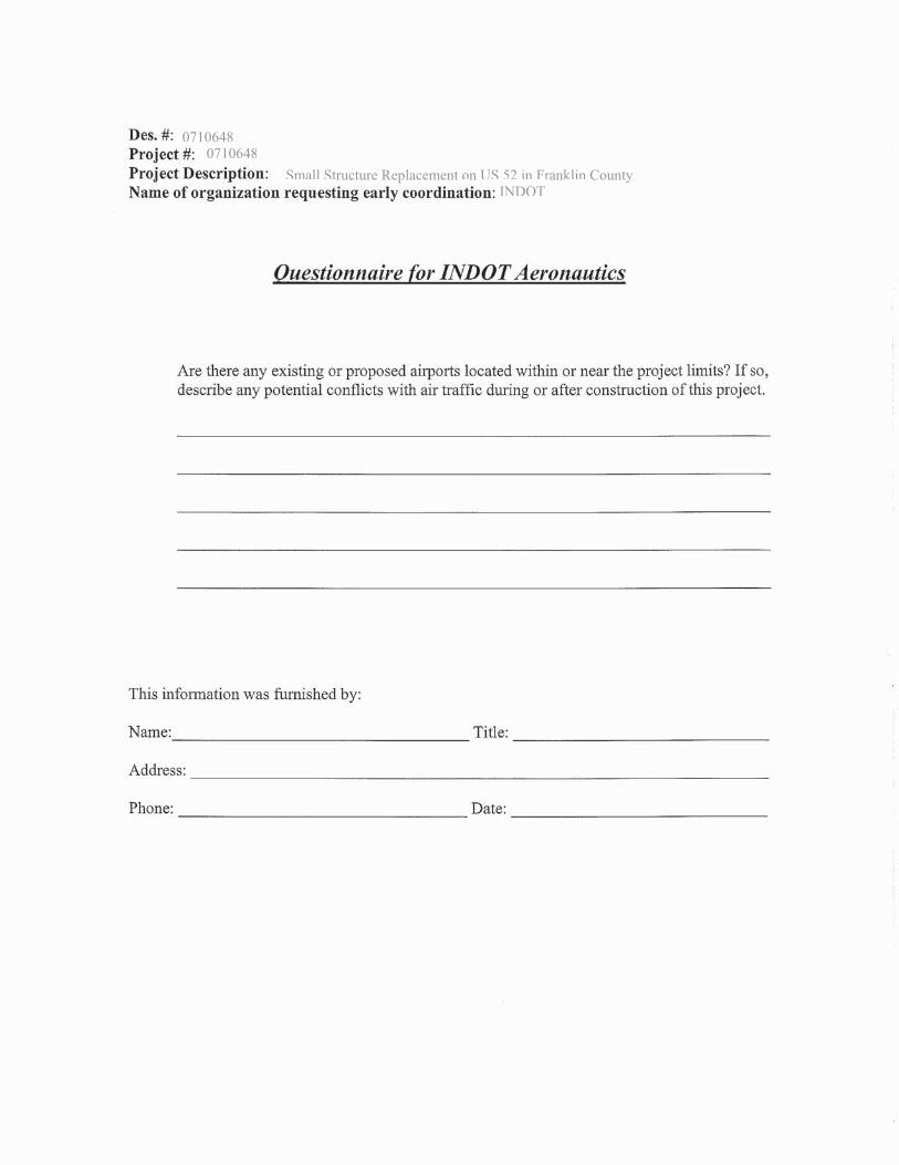
Re: Des. #0710648, Small Structure on US 52 over Goose Creek, Franklin County
Reviewer,
The Indiana Department of Transportation intends to proceed with a project involving the aforementioned small structure replacement in Franklin County. This letter is part of the early coordination phase of the environmental review process. We are requesting comments from your area of expertise regarding any possible environmental effects associated with this project. Please use the above designation numbers and description in your reply. We will incorporate your comments into a study of the project’s environmental impacts.
This project will replace the small structure on US 52 over Goose Creek, 4.17 miles east of SR 229, within Metamora Township of Franklin County, Indiana. The project is approximately 0.19 miles in length. Vertical alignment changes are planned for Goose Creek Road. Goose Creek Road will be realigned approximately 20 feet to the east of where it currently intersects with US 52.
The land use in the immediate vicinity of the project area comprises of residential land north and agricultural land south of the structure. The Whitewater Canal is present on the south side of the structure.
The existing structure is a concrete slab top culvert that has been widened with precast concrete beams, with a rise of 7feet, a span of 15 feet, and a length of 28 feet. There is deterioration of the concrete slab next to the precast beam, causing a 1 foot gap between the slab and the beams warranting replacement. The existing US 52 approach cross section consists of two 12 foot travel lanes with 1 foot paved (2 feet usable) shoulders. Guardrail is present at the structure and wraps around the northwest corner of the Goose Creek Road/US 52 intersection. The canal is approximately 30-50 feet from the edge of pavement on the south side US 52 within the project limits.
The proposed replacement structure is to be of a precast concrete box structure with a rise of 6 feet, span of 16 feet, and a length of 60 feet. This structure size will allow for 12 foot lanes and the addition of 4 foot paved shoulder at the structure and where guardrail is installed. Approximately 765 feet of guardrail is required for this project of which approximately 250 feet will be installed where current guardrail currently exist. Approximately 515 feet of new guardrail will be installed where no guardrail currently exist. The proposed roadway is recommended to be 12 foot lanes with 2 foot paved (3 feetusable) shoulders where no guardrail is present.

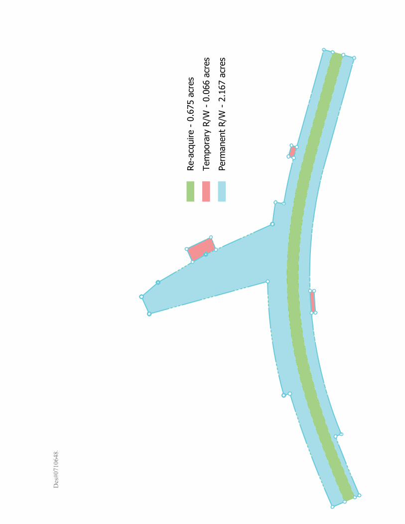
Total new right-of-way in the amount of 2.233 acres is required for this project and consists of 2.167 acres permanent and 0.066 acres temporary right-of-way. New right-of-way will consist of residential and forested land.
Impacts to the channel are expected to include removal of existing structure, installation of new structure, and placement of riprap. The INDOT Environmental Section will perform waters and wetlands determinations.
Should we not receive your response within thirty (30) calendar days from the date of this letter, it will be assumed that your agency feels that there will be no adverse effects incurred as a result of the proposed project. However, should you find that an extension to the response time is necessary; a reasonable amount may be granted upon request. If you have any questions regarding this matter, please feel free to contact Brad Williamson, of the INDOT Seymour District Environmental Section, at (812)-524-3971 or [email protected]
Thank you in advance for your input.
Sincerely,
Brad WilliamsonEnvironmental ManagerINDOT Seymour District
BLW/XXXAttachment
Brad Williiamson
Digitally signed by Brad Williiamson DN: cn=Brad Williiamson, o, ou, [email protected], c=US Date: 2011.04.12 09:34:51 -04'00'

Attachment A
Maps, Photos, Plans


£¤52
Goose C
reek Rd
Photo Key MapSmall Structure over Goose Ck located 4.17 miles east of SR 229
US 52, Franklin County, IndianaDes No. 0710648, Small Structure Replacement
º0.03 0 0.030.015
Miles
1:1,494Scale
Sources: Non Orthophotography Data - Obtained from the State of Indiana Geographical Information Office LibraryOrthophotography - Obtained from Indiana Map Framework Data(www.indianamap.org) Map Projection: UTM Zone 16 N Map Datum: NAD83
This map is intended to serve as an aid in graphic representation only. This information is not warranted for accuracy or other purposes.
State Routes TYPEInterstate
State Route
US Route
Local Road
111111111111 222222222222222222222
333333333333333
444444444444444444444444444444444
55555555555555555555555555
6666666666666666666666
¤££¤££££££77777777777777777777¤¤£
8888888888888888888888888
999999999999999999999999
1010101010101001010010100010110001010
111111111111111111111111111111112111221222121212121121212212221212

Des
igna
tion
#07
1064
8,S
mal
l Str
uctu
reR
epla
cem
ent
onU
S 5
2ov
er G
oose
Cre
ek,F
rank
linC
ount
y In
dian
a
Pho
to1-
Look
ing
east
atca
nala
ndaq
uadu
ct s
truc
ture
Pho
to2-
Roc
khe
adw
allf
or a
quad
uct
Pho
to3-
Look
ing
upst
ream
atG
oose
Cre
ekfr
omR
R b
ridg
e
P
hoto
4-Lo
okin
gw
est
atca
nal

Des
igna
tion
#07
1064
8,P
age
2
Pho
to5-
Sou
thea
stqu
adra
ntfr
omU
S 5
2sm
all s
truc
ture
P
hoto
6-N
orth
east
quad
rant
fro
mU
S 5
2sm
all s
truc
ture
Pho
to7-
Look
ing
sout
h(d
owns
trea
m)
from
US
52
Pho
to8-
Sou
thw
est
quad
rant
from
US
52
smal
l str
uctu
re

Des
igna
tion
#07
1064
8, P
age
3
Pho
to9-
Look
ing
nort
hat
outl
etof
US
52
smal
l str
uctu
re
P
hoto
10-N
orth
wes
tqu
adra
ntfr
omU
S 5
2sm
all s
truc
ture
Pho
to11
-Bar
nsea
stof
Goo
seC
reek
Roa
d
P
hoto
12-I
nlet
area
of U
S 5
2sm
all s
truc
ture
onno
rth
side
of
US
52
Deem
oliti
onof
this
baarn
prppppop
osed
Des
#071
0648
.
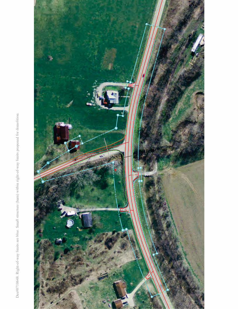
Des
#071
0648
. Rig
ht-o
f-w
ay li
mits
are
blue
.Sm
all s
truct
ure
(bar
n) w
ithin
righ
t-of-
way
lim
itspr
opos
ed fo
r dem
oliti
on.


Attachment B
Agency Questionnaires

U.S. Department of Agriculture
FARMLAND CONVERSION IMPACT RATING
PART I (To be completed by Federal Agency) Date Of Land Evaluation Request
Name of Project Federal Agency Involved
Proposed Land Use County and State
PART II (To be completed by NRCS) Date Request Received By NRCS
Person Completing Form:
Does the site contain Prime, Unique, Statewide or Local Important Farmland?
(If no, the FPPA does not apply - do not complete additional parts of this form)
YES NO
Acres Irrigated
Average Farm Size
Major Crop(s)
Farmable Land In Govt. Jurisdiction
Acres: %
Amount of Farmland As Defined in FPPA
Acres: %
Name of Land Evaluation System Used
Name of State or Local Site Assessment System
Date Land Evaluation Returned by NRCS
Alternative Site Rating PART III (To be completed by Federal Agency) Site A Site B Site C Site D
A. Total Acres To Be Converted Directly
B. Total Acres To Be Converted Indirectly
C. Total Acres In Site
PART IV (To be completed by NRCS) Land Evaluation Information
A. Total Acres Prime And Unique Farmland
B. Total Acres Statewide Important or Local Important Farmland
C. Percentage Of Farmland in County Or Local Govt. Unit To Be Converted
D. Percentage Of Farmland in Govt. Jurisdiction With Same Or Higher Relative Value
PART V (To be completed by NRCS) Land Evaluation Criterion
Relative Value of Farmland To Be Converted (Scale of 0 to 100 Points)
PART VI (To be completed by Federal Agency) Site Assessment Criteria
(Criteria are explained in 7 CFR 658.5 b. For Corridor project use form NRCS-CPA-106) Maximum
Points Site A Site B Site C Site D
1. Area In Non-urban Use (15)
2. Perimeter In Non-urban Use (10)
3. Percent Of Site Being Farmed (20)
4. Protection Provided By State and Local Government (20)
5. Distance From Urban Built-up Area (15)
6. Distance To Urban Support Services (15)
7. Size Of Present Farm Unit Compared To Average (10)
8. Creation Of Non-farmable Farmland (10)
9. Availability Of Farm Support Services (5)
10. On-Farm Investments (20)
11. Effects Of Conversion On Farm Support Services (10)
12. Compatibility With Existing Agricultural Use (10)
TOTAL SITE ASSESSMENT POINTS 160
PART VII (To be completed by Federal Agency)
Relative Value Of Farmland (From Part V) 100
Total Site Assessment (From Part VI above or local site assessment) 160
TOTAL POINTS (Total of above 2 lines) 260
Site Selected:
Date Of Selection
Was A Local Site Assessment Used?
YES NO
Reason For Selection:
Name of Federal agency representative completing this form: Date:
(See Instructions on reverse side) Form AD-1006 (03-02)
Des#07106484/15/2011
INDOT (Federally funded project)INDOT Right-of-way Franklin County, Indiana
2.167
2.167
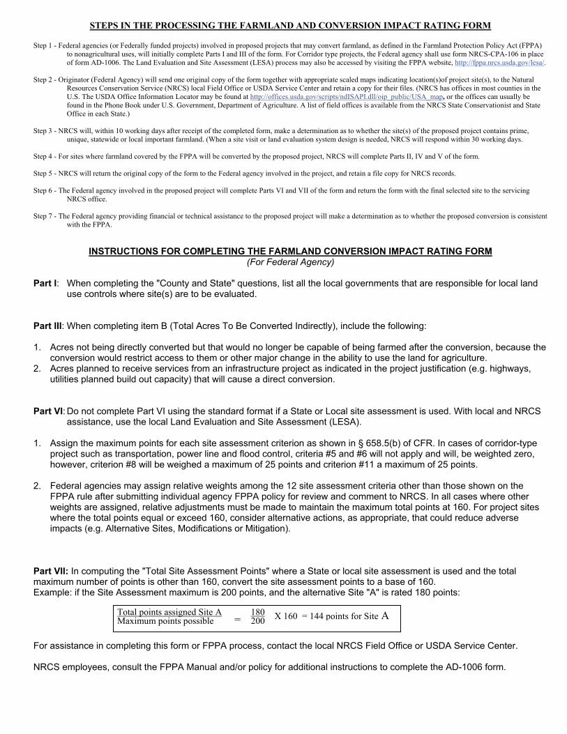
STEPS IN THE PROCESSING THE FARMLAND AND CONVERSION IMPACT RATING FORM
Step 1 - Federal agencies (or Federally funded projects) involved in proposed projects that may convert farmland, as defined in the Farmland Protection Policy Act (FPPA)
to nonagricultural uses, will initially complete Parts I and III of the form. For Corridor type projects, the Federal agency shall use form NRCS-CPA-106 in place of form AD-1006. The Land Evaluation and Site Assessment (LESA) process may also be accessed by visiting the FPPA website, http://fppa.nrcs.usda.gov/lesa/.
Step 2 - Originator (Federal Agency) will send one original copy of the form together with appropriate scaled maps indicating location(s)of project site(s), to the Natural
Resources Conservation Service (NRCS) local Field Office or USDA Service Center and retain a copy for their files. (NRCS has offices in most counties in the U.S. The USDA Office Information Locator may be found at http://offices.usda.gov/scripts/ndISAPI.dll/oip_public/USA_map, or the offices can usually be found in the Phone Book under U.S. Government, Department of Agriculture. A list of field offices is available from the NRCS State Conservationist and State Office in each State.)
Step 3 - NRCS will, within 10 working days after receipt of the completed form, make a determination as to whether the site(s) of the proposed project contains prime,
unique, statewide or local important farmland. (When a site visit or land evaluation system design is needed, NRCS will respond within 30 working days. Step 4 - For sites where farmland covered by the FPPA will be converted by the proposed project, NRCS will complete Parts II, IV and V of the form. Step 5 - NRCS will return the original copy of the form to the Federal agency involved in the project, and retain a file copy for NRCS records. Step 6 - The Federal agency involved in the proposed project will complete Parts VI and VII of the form and return the form with the final selected site to the servicing
NRCS office. Step 7 - The Federal agency providing financial or technical assistance to the proposed project will make a determination as to whether the proposed conversion is consistent
with the FPPA.
INSTRUCTIONS FOR COMPLETING THE FARMLAND CONVERSION IMPACT RATING FORM (For Federal Agency)
Part I: When completing the "County and State" questions, list all the local governments that are responsible for local land
use controls where site(s) are to be evaluated. Part III: When completing item B (Total Acres To Be Converted Indirectly), include the following: 1. Acres not being directly converted but that would no longer be capable of being farmed after the conversion, because the
conversion would restrict access to them or other major change in the ability to use the land for agriculture. 2. Acres planned to receive services from an infrastructure project as indicated in the project justification (e.g. highways,
utilities planned build out capacity) that will cause a direct conversion. Part VI: Do not complete Part VI using the standard format if a State or Local site assessment is used. With local and NRCS
assistance, use the local Land Evaluation and Site Assessment (LESA). 1. Assign the maximum points for each site assessment criterion as shown in § 658.5(b) of CFR. In cases of corridor-type
project such as transportation, power line and flood control, criteria #5 and #6 will not apply and will, be weighted zero, however, criterion #8 will be weighed a maximum of 25 points and criterion #11 a maximum of 25 points.
2. Federal agencies may assign relative weights among the 12 site assessment criteria other than those shown on the
FPPA rule after submitting individual agency FPPA policy for review and comment to NRCS. In all cases where other weights are assigned, relative adjustments must be made to maintain the maximum total points at 160. For project sites where the total points equal or exceed 160, consider alternative actions, as appropriate, that could reduce adverse impacts (e.g. Alternative Sites, Modifications or Mitigation).
Part VII: In computing the "Total Site Assessment Points" where a State or local site assessment is used and the total maximum number of points is other than 160, convert the site assessment points to a base of 160. Example: if the Site Assessment maximum is 200 points, and the alternative Site "A" is rated 180 points: For assistance in completing this form or FPPA process, contact the local NRCS Field Office or USDA Service Center. NRCS employees, consult the FPPA Manual and/or policy for additional instructions to complete the AD-1006 form.
Total points assigned Site A 180 Maximum points possible 200 = X 160 = 144 points for Site A

Indiana Wellhead Protection Program Indiana Department of Environmental Management · Drinking Water Branch · Ground Water Section
Wellhead Protection Area Proximity Request Form Use this form to request information on the proximity of your site to a Wellhead Protection Area (WHPA). Please fill out the form completely and mail, email or fax to the Drinking Water Branch/Ground Water Section. Upon review, you will be contacted with official WHPA Proximity Determination documentation. Send to:
Indiana Dept. of Environmental Management Drinking Water Branch/Ground Water Section ATTN: James Sullivan 100 N. Senate Avenue Indianapolis, IN 46204
Fax:Phone:Email:
Date
Person Requesting Information
Name
Company
Address
Phone
Site Information
Address(please include
zip code)
AdditionalComments
For Office Use Only Date and Time Request
Received
Date and Time Request Filled
Brad Williamson
INDOT, Seymour District
185 Agrico LaneSeymour
gIn. 47274
812-524-3971
Small structure replacement on US 52 in Franklin County. See maps and details above.
4/12/2011
07106480710648
Small Structure Replacement on US 52 in Franklin CountyINDOT

07106480710648
Small Structure replacement on US 52, Franklin County
INDOT

07106480710648
Small Structure replacement on US 52 in Franklin CountyINDOT