revised groundwater quality trend monitoring work plan
TRANSCRIPT
Wood Environment & Infrastructure Solutions, Inc.
1281 East Alluvial Avenue, Suite 101
Fresno, CA 93720-2659
USA
T: 559-264-2535
www.woodplc.com
‘Wood’ is a trading name for John Wood Group PLC and its subsidiaries
July 31, 2018
Project FR1216043A
Mr. Joseph D. Hughes
Klein, DeNatale, Goldner, LLC
4550 California Avenue, Second Floor
Bakersfield, California 93309
Subject: Addendum No. 1 – Revised Groundwater Quality Trend Monitoring Work Plan
Westside Water Quality Coalition
Western Tulare Lake Basin, California
Dear Mr. Hughes:
Wood Environment & Infrastructure Solutions, Inc. (Wood), has prepared this Addendum No. 1 -Revised
Groundwater Quality Trend Monitoring Work Plan on behalf of Klein, DeNatale, Goldner, LLP, and your
client, the Westside Water Quality Coalition (Coalition). The Coalition is acting as a Third-Party Coalition
pursuant to Waste Discharge Requirements General Order R5-2013-0120 (General Order) issued by the
California Regional Water Quality Control Board (RWQCB) in September 2013. The Coalition entered into
a Memorandum of Understanding with the Central Valley Groundwater Monitoring Collaborative on
October 31, 2017, and is currently a participating member.
Introduction:
This addendum is in response to the RWQCB letter dated June 29, 2018, Review of the Westside Water
Quality Coalition Revised Groundwater Quality Trend Monitoring Work Plan. The letter requested that the
Coalition include the following information:
1. A rational for the sufficiency of the number of proposed wells to provide adequate coverage in
the Coalition’s Area;
2. A list of the proposed trend monitoring wells that you have permission to sample, and that have
been field verified;
3. Well construction details (e.g., depth, screen interval, well seal information, etc.) for all trend
monitoring wells;
4. An additional trend monitoring well to replace Starrh 9K No.2 well; and
5. Trend monitoring well(s) to monitor groundwater in T28S R21E, MDB&M

Mr. Joseph D. Hughes
Klein, DeNatale, Goldner, LLC
July 31, 2018
Page 2
Revised Groundwater Quality Trend Monitoring Program
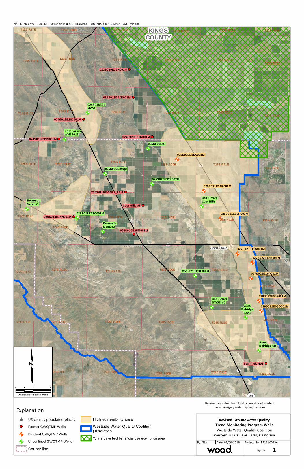
The Revised Groundwater Quality Trend Monitoring Program (GWQTMP) work plan originally designated
20 wells for the GWQTMP network (13 unconfined and 7 perched zone wells). The Coalition has
subsequently revised their GWQTMP well network based on the comments provided by the RWQCB and
due to the result of the Coalitions field vetting process of the original 20 proposed wells previously
selected for groundwater monitoring.
Coalition personnel conducted field verification for wells and contacted well owner/operators to inquire
about well construction information and to secure site access and permission to sample individual wells.
Wood also obtained well construction records from the California Department of Water Resources (DWR)
Well Completion Report Map Application (https://dwr.maps.arcgis.com/apps/webappviewer/
index.html?id=181078580a214c0986e2da28f8623b37) for each Township, Range, and Section located
within the Coalition boundary. The vetting process found that nine of the originally proposed unconfined
groundwater wells could not be field located, were former test wells that had been subsequently
destroyed, or consisted of wells with little or no well construction information or no associated DWR
record. These wells are shown on Figure 1 in red symbology.
Ten alternative wells were identified as suitable replacements based on well construction and/or proximity
to irrigated agricultural lands. Two of these wells are currently being installed by the United States
Geologic Survey (USGS); the USGS Lost Hills Well and USGS BWSD Well#5. Complete well construction
information for these wells is not currently available, but will be transmitted to the RWQCB when the wells
are completed. USGS has indicated to the Coalition that the wells will be available for groundwater
sampling during the fall 2018 GWQTMP monitoring event. The Coalition intends to sample the within the
cluster completed in first encountered groundwater.
The revised GWQTMP well network now consists of 21 monitoring wells. Thirteen of these wells are
screened in unconfined groundwater wells (Figure 1, in green symbology) and 8 wells are screened in
perched groundwater (Figure 1, in orange symbology). Table 1 contains available well construction
information provided by the well owner or contained in DWR records. Well construction records are
provided in Attachment A.
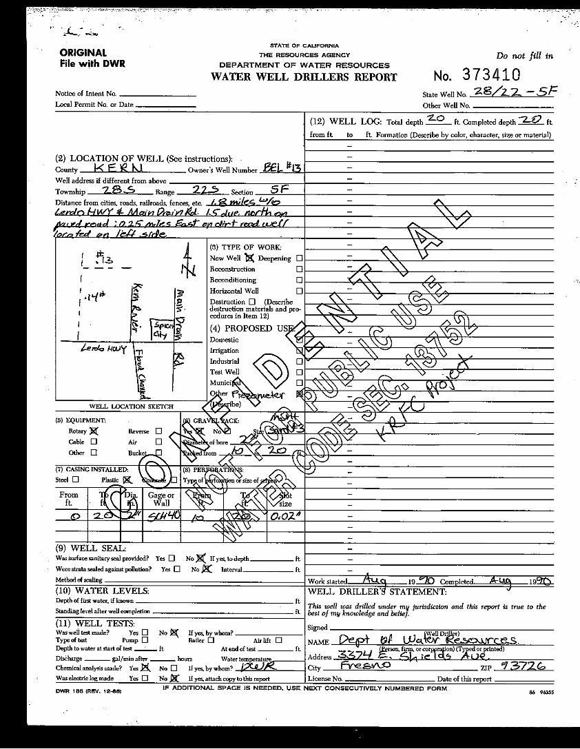
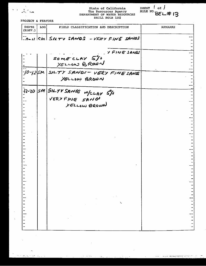
Two GWQTMP wells, Berrenda Mesa #1 and Berrenda Mesa #3 do not have available well construction
documentation from DWR records. The owner of Berrenda Mesa #1 has provided the Coalition with verbal
information regarding the wells perforated interval (Table 1) and the Coalition is performing research to
attempt to locate well construction information for Berrenda Mesa #3 well.
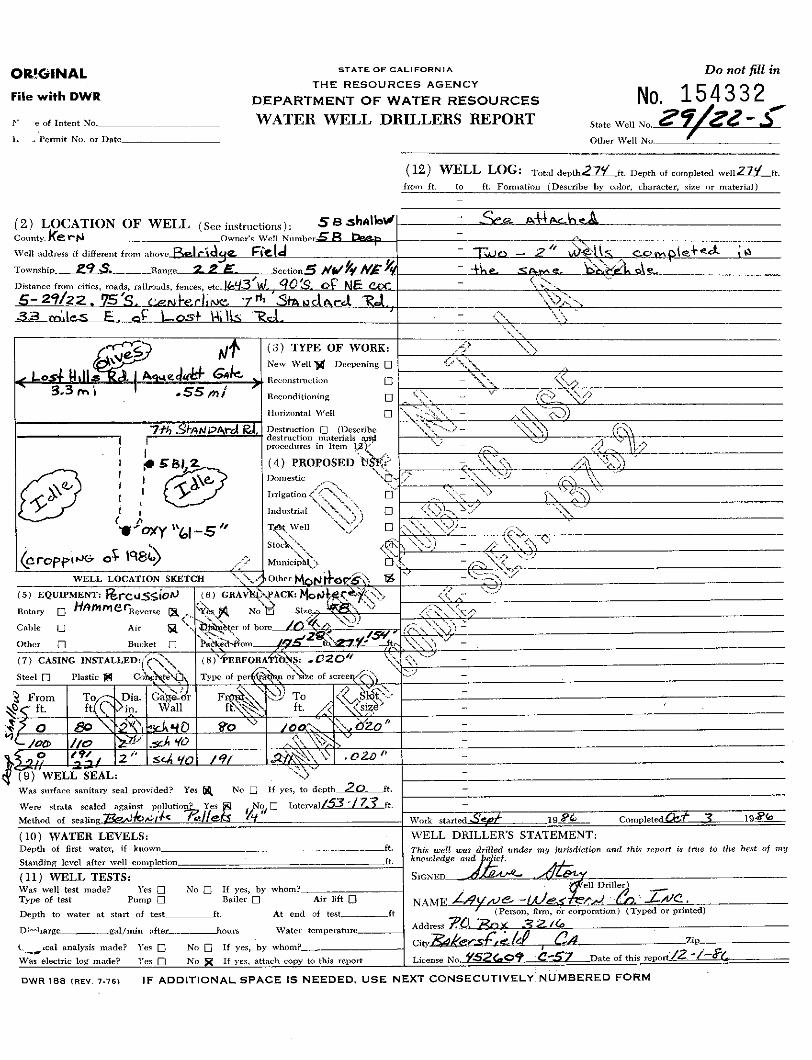
The RWQCB requested that a replacement to Starrh 9K No. 2 well be added to the GWQTMP network.
There is no adequate replacement well for Star2K No. 2 on irrigated land south of the location of Aera
Energy LLC (Aera), Belridge well 5B2 in T29SR22E Sections 07, 08, 09, or 18. All wells in these sections have
screened intervals located either across or below the E-Clay aquitard. There are shallow wells at the Clean
Harbors facility in Section 16; however, these wells are not downgradient of any irrigated agriculture.
There are also shallow wells that monitor the Cymric produced water impoundments, but they are also
not located downgradient of irrigated lands. We are proposing to use only Aera Belridge well 5B2 to
monitor irrigated lands in T29SR22E; this well is located directly downgradient of irrigated lands.

Mr. Joseph D. Hughes
Klein, DeNatale, Goldner, LLC
July 31, 2018
Page 3
The RWQCB requested that one or more wells be located in T28SR21E even though shallow monitoring
wells in this section are impacted by nitrogen sourced from former impoundments not associated with
irrigated agriculture. The Coalition proposes to use a new USGS well BWSD #5 in Section 8 of T28SR21E
and monitoring well Aera Belridge 13A1 located in Section 13. In addition, the Coalition plans to add a
perched zone well in Section 8 of T28SR22E situated east of irrigated land. These wells will provide
adequate coverage of first encountered groundwater in this Township/Range downgradient of irrigated
agriculture.
Rational and Adequacy of the GWQTMP Monitoring Network
The rationale for the location and number of wells is based on a general continuity in crop types, primarily
almond and pistachio, in which similar farming practices are applied within the Coalition. The general
continuity in crop types and farming practice favors a groundwater monitoring network of fewer wells
because the variability expected in application of irrigation, fertilizers, and soil amendments is low.
Furthermore, the water quality within the Coalition is generally poor in most areas occupied by irrigated
lands with some areas having total dissolved solids concentrations greater than 3,000 in the perched and
unconfined/semi-confined aquifers. There are also no communities that use groundwater for municipal
water supply downgradient of irrigated lands. These communities use imported treated surface water or
groundwater.
The revised GWQTMP network consisting of 21 monitoring wells. Thirteen wells are located in the upper
unconfined aquifer with a density of about one well per Township/Range where irrigated agriculture is
present. Two additional wells were added in Township 28S Range 21East to complete coverage of
irrigated agriculture in this area. Eight wells are located in the perched aquifer at a spacing of about one
or two wells per Township/Range. The coverage of the perched aquifer in the A-zone aquifer is more
complete with the addition of an eighth well. Nineteen wells have established well construction data. Only
two wells have incomplete information and the Coalition is still researching as to whether well
construction information is available.
There are no existing monitoring or water supply wells in the Dudley Ridge area, the two former GWQTMP
wells were found to no longer exist during field verification. Groundwater flow in the Dudley Ridge areas
is toward the adjacent Tulare Lake Sub-Basin which has been delisted for Municipal and Agricultural
beneficial use above the E-Clay aquitard due to the presence of poor water quality. Furthermore, there are
no plan to develop water resources in Dudely Ridge area due to poor water quality. Acknowledging these
facts, the Coalition does not propose to monitor impacts of irrigated agriculture in this area since any
negative impact will not affect any current or future beneficial use in the downgradient designated area.

Mr. Joseph D. Hughes
Klein, DeNatale, Goldner, LLC
July 31, 2018
Page 5
APPROVAL AND ACCEPTANCE
If this Addendum No. 7 meets with your approval and you wish Wood to proceed with the scope of
work described herein with an estimated budget of $110,850, please sign and return this authorization.
Approval and acceptance of this proposal are acknowledged by the signature of duly authorized
representative of Klein, DeNatale, Goldner, Cooper, Rosenlieb & Kimball, LLP.
Klein, DeNatale, Goldner, LLC
__________________________ ______________________ _______________
Signature Title Date

Table

Table 1Summary of Well Construction - Groundwater Quality Trend Monitoring Network
Trend Monitoring Well ID State Well Number Source Information Well Type Latitude Longitude
Top of Casing
Elevation (feet)
Ground Surface
Elevation (feet)
Well Depth (feet bgs)1
Screen Interval
(feet bgs)1
Casing Size (inches)
Well Seal (type and footage
bgs)Install Date
Field Verified
Permission To Sample
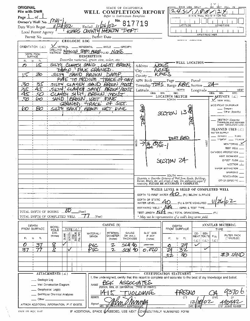
MW-1 024S018E24 024S018E24D DWR Well Record Monitoring 35.832782 -119.982134 TBD2 437 77 37-77 2Cement (0-29)
Bentonite(29-32)
11/26/2002 WWQC Yes
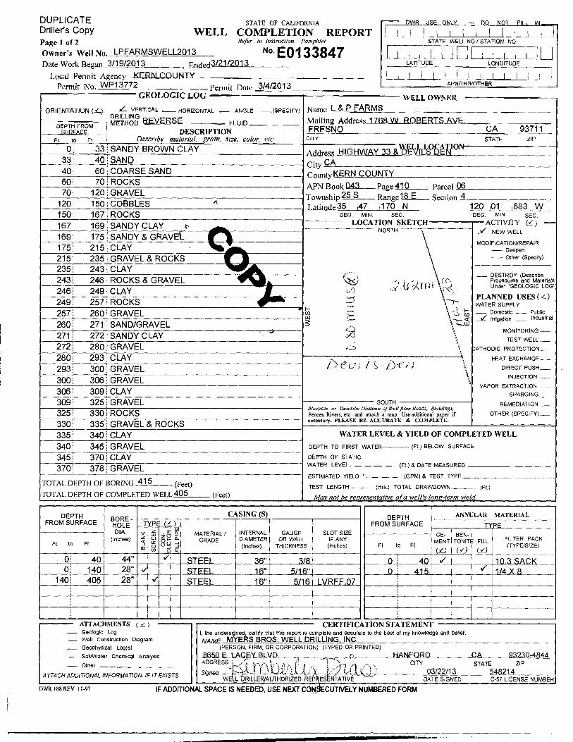
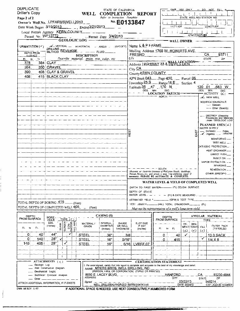
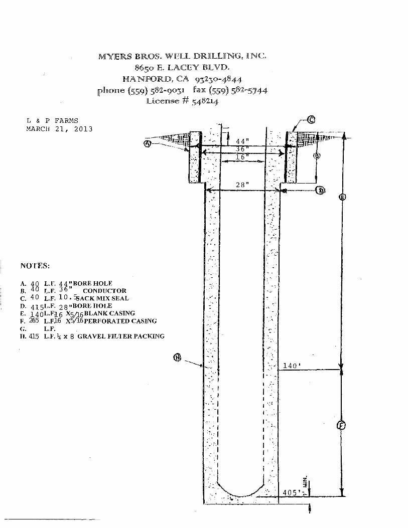
LP Farms Well 3013 025S018E04A DWR Well Record Irrigation 35.788646 -120.028073 TBD 608 405 140-405 16 Cement (0-40) 03/21/2013 WWQC Yes
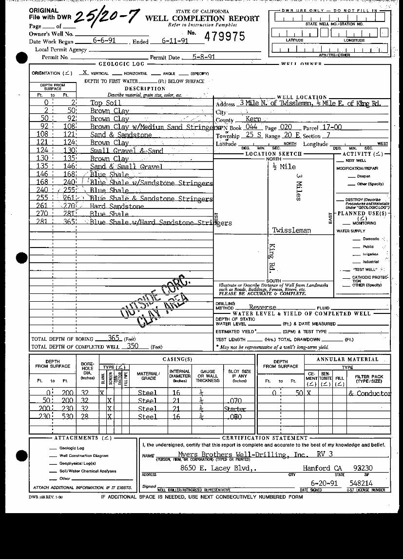
025S020E07 025S020E07 DWR Well Record Irrigation 35.774692 -119.858717 TBD 319 530 50-530 16-21 Cement (0-50) 05/08/1991 WWQC Yes
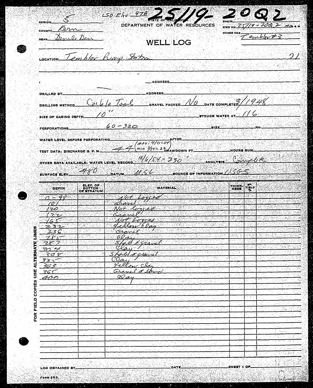
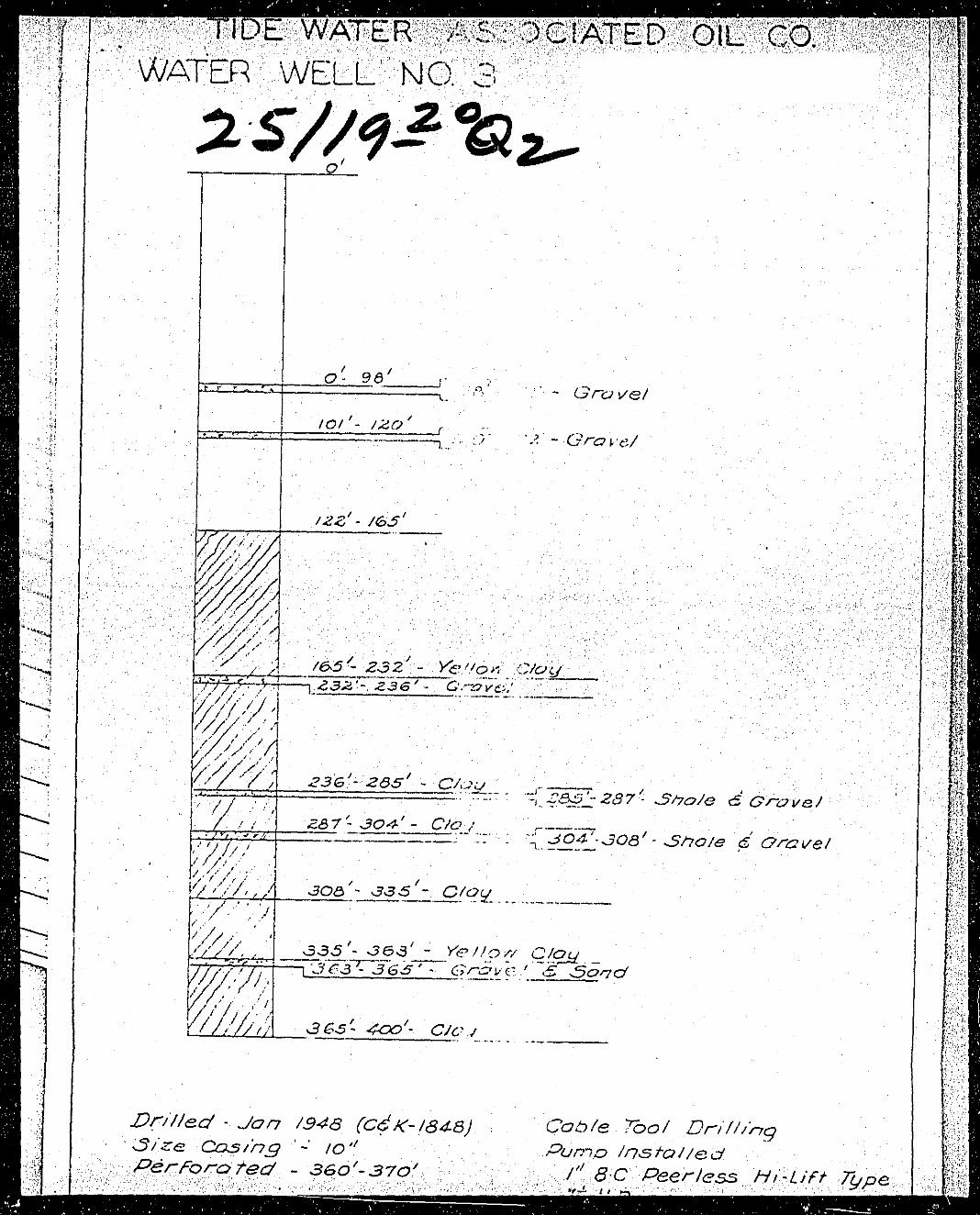
025S020E20Q002M 025S020E20Q002M DWR Well Record Irrigation 35.716095 -119.849763 TBD 480 400 60-320 10 Not Specified 03/01/1948 WWQC Yes
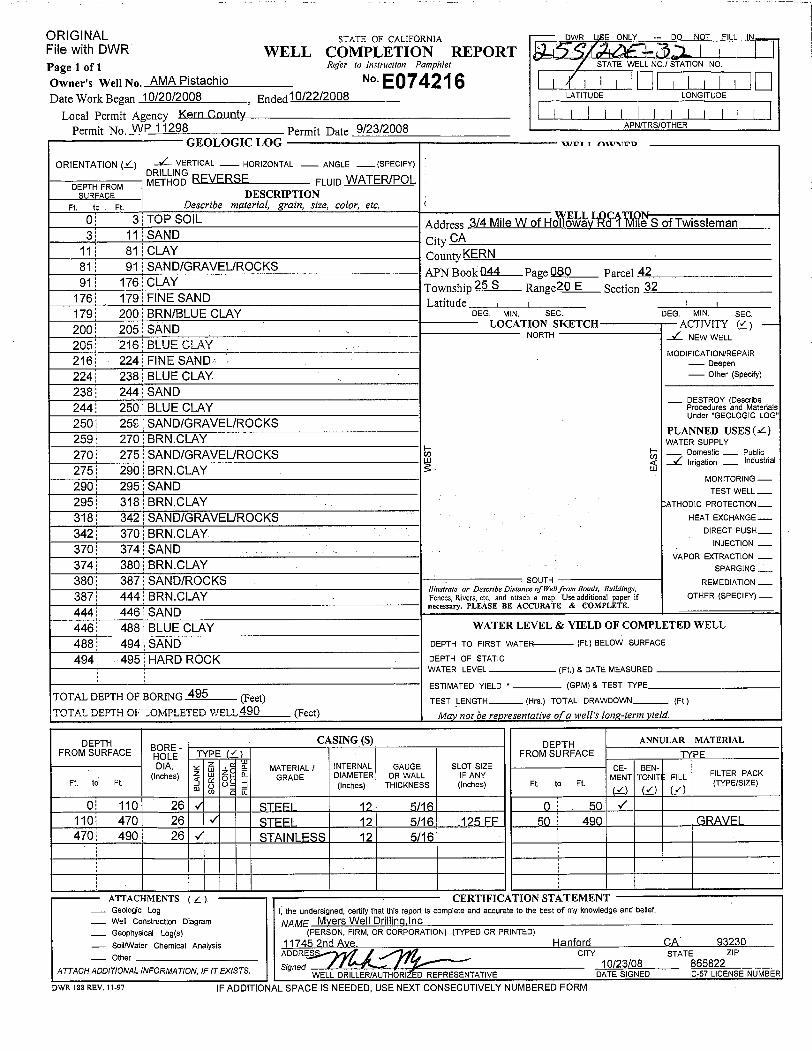
025S020E32E007M 025S020E32E007M DWR Well Record Irrigation 35.716095 -119.849763 TBD 402 490 110-470 12 Cement (0-50) 10/22/2008 WWQC Yes
026S018E23C001M 02618E023C001M DWR Well Record Irrigation 35.657976 -120.002459 TBD 670 186 160-186 16 Not Specified 04/08/1958 WWQC Yes
Berenda Mesa #3 026S019E29F No Current Record Irrigation 35.636035 -119.948245 TBD 755 --3 -- -- -- -- WWQC Yes
USGS Lost Hills Well4 026S021E07K TBD by USGS Piezometer 35.679594 -119.748315 TBD TBD TBD TBD TBD TBD TBD WWQC Yes
Berrenda Mesa-1 026SR17E14AOwner Verbal
CommunicationDomestic 35.668823 -120.090742 TBD 654 250 -- -- Not Specified -- WWQC Yes
AeraBelridge_19M1 027S021E19K001M
Area 2012 Post-Closure Groundwater Monitoring
Planfor Former Surface
Impoundments
Monitoring 35.56421 -119.760748 521.11 518.81 237170-200; 220-230
5Not Avaliable in
Report07/06/2006 WWQC Verbal
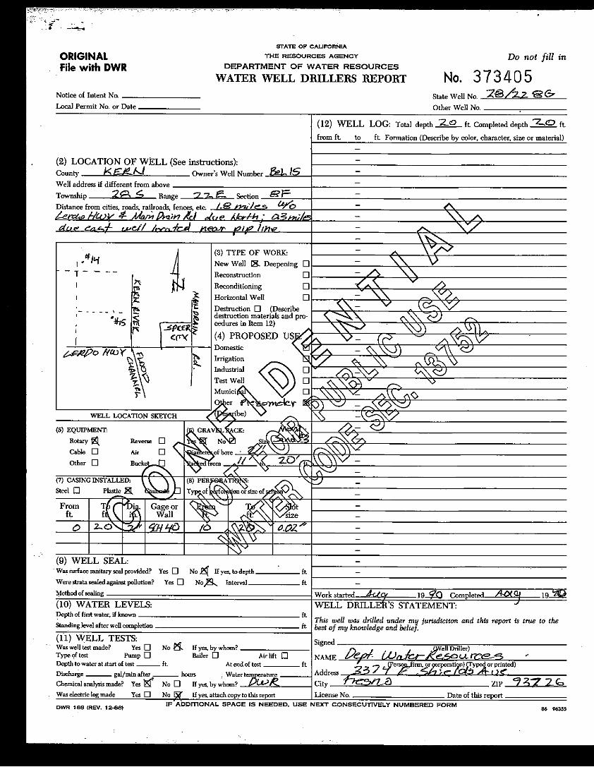
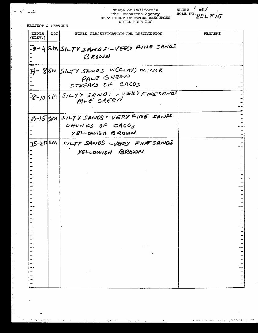
USGS Well BWSD #5 028S021E08A001M USGS E-Mail Piezometer 35.512571 -119.726464 TBD 489 300 260 280 TBD 07/19/2018 WWQC Yes
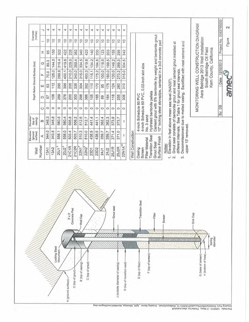
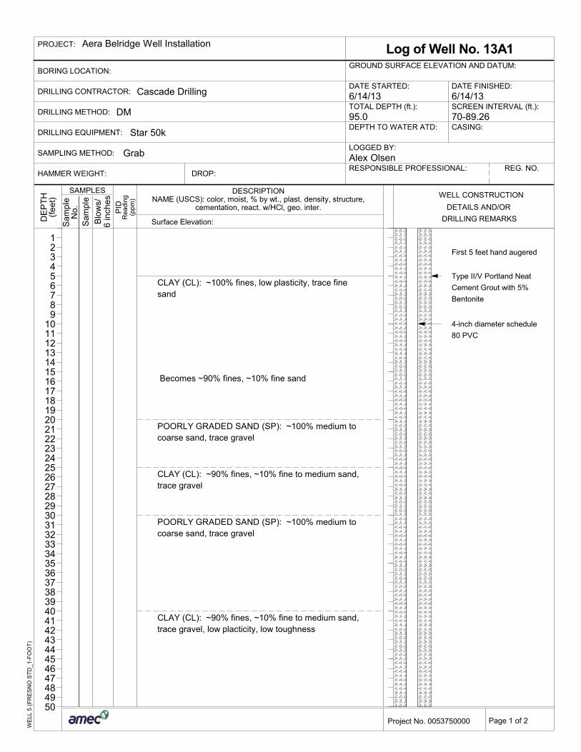
Aera Belridge 13A1 028S021E13H Well Contruction Log Monitoring 35.495564 -119.658 346.273 343.955 90 70-89.26 4Cement (0-57)
Bentonite(57-63)
06/14/2013 WWQC Yes
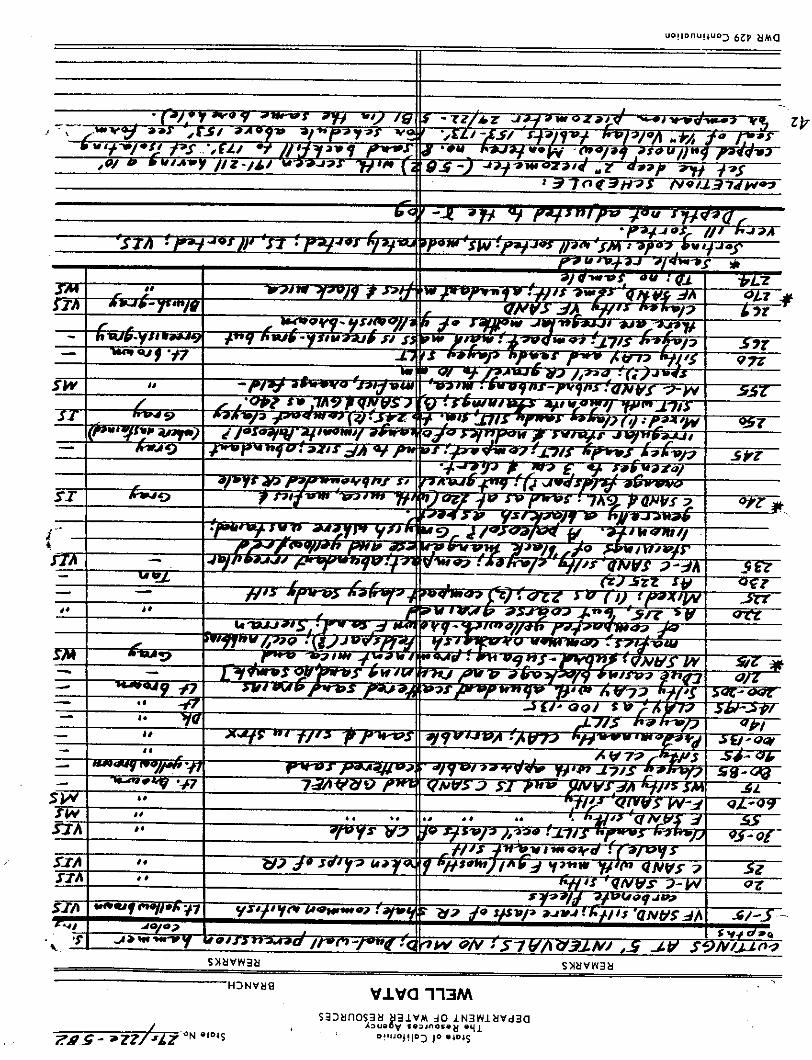
AeraBelridge_5B2 029S022E05B002M DWR Well Record Monitoring 35.441081 -119.630269 336.5 336.1 110 80-100 2 Bentonite (0-20) 10/03/1986 WWQC Verbal
Unconfined/Semi-Confined Aquifer
Westside Water Quality CoalitionWestern Tulare Lake Basin, California
Page 1 of 2I:\FR12s\FR1216043A\Archive\FR1216043-024.xlsx

Table 1Summary of Well Construction - Groundwater Quality Trend Monitoring Network
Trend Monitoring Well ID State Well Number Source Information Well Type Latitude Longitude
Top of Casing
Elevation (feet)
Ground Surface
Elevation (feet)
Well Depth (feet bgs)1
Screen Interval
(feet bgs)1
Casing Size (inches)
Well Seal (type and footage
bgs)Install Date
Field Verified
Permission To Sample
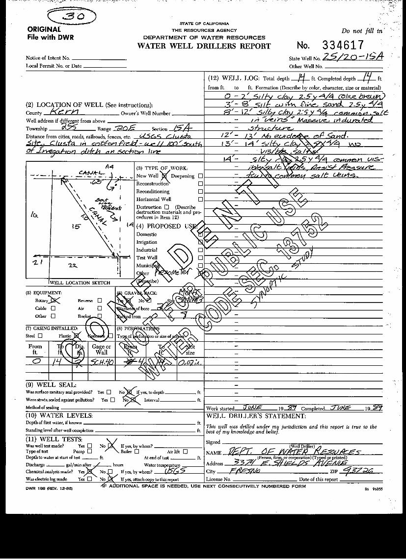
DWR T25S/R20E-15A 025S020E15A001M DWR Well Record Piezometer 35.757146 -119.799327 TBD 262 14 4-14 2 #3 Sand (0-8) 06/01/1989 WWQC Yes
DWR T25S/R21E-31R1_10 025S021E31R001M DWR Well Record Monitoring 35.70518 -119.745008 TBD 237 19 9-19 2 Bentonite (0-10) 11/06/1998 WWQC Yes
DWR T26S/R21E-16R1 026S021E16R001M DWR Well Record Piezometer 35.659687 -119.71014 TBD 292 22 12-22 2 #3 Sand (0-14) 06/01/1989 WWQC Yes
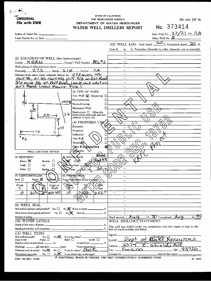
DWR T27S/R21E-11A_BEL #2 027S021E11A001M DWR Well Record Piezometer 35.60153 -119.67556 TBD 277 20 10-20 2Not Specified
(0-10)08/01/1990 WWQC Yes
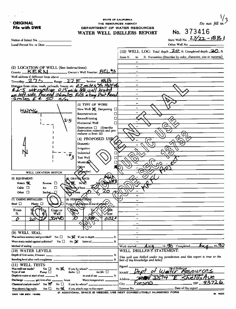
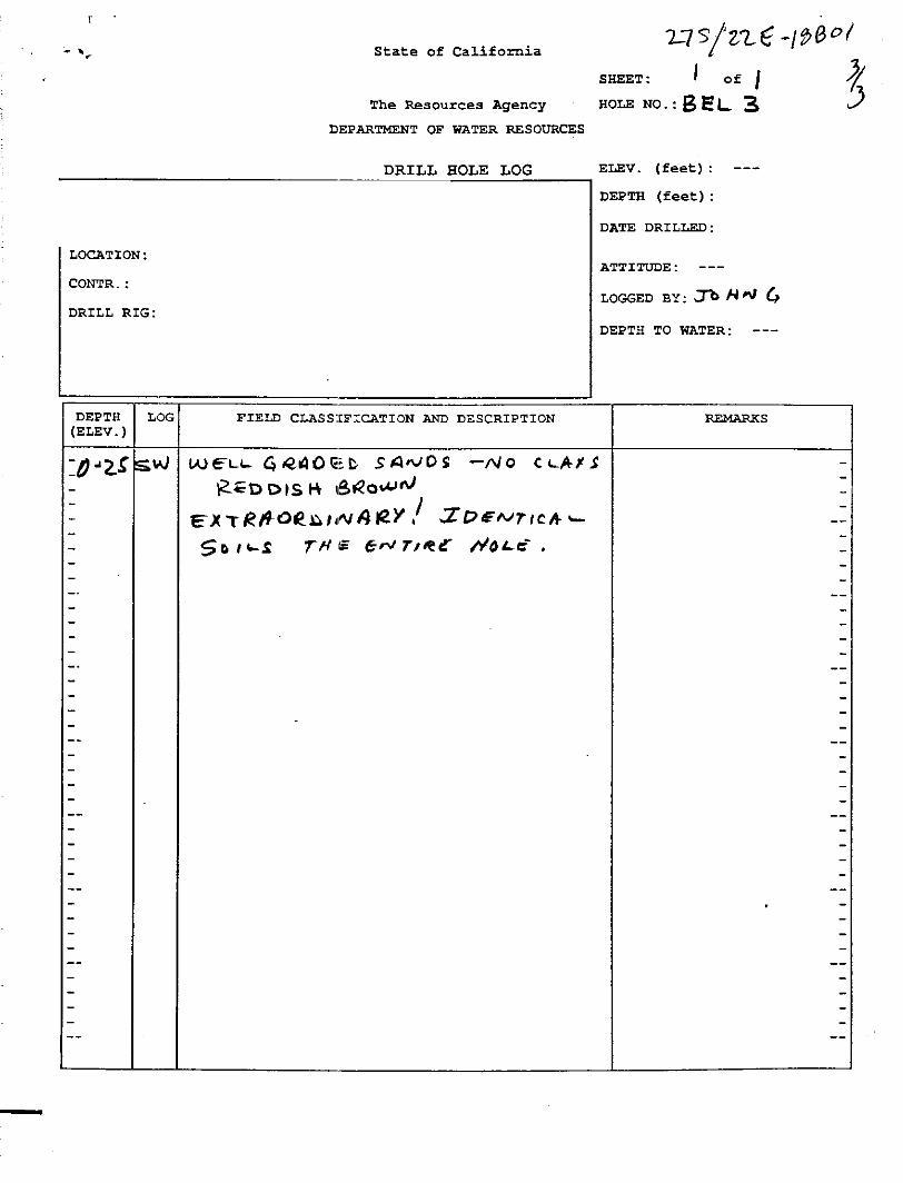
DWR T27S/R22E-18B1_BEL #3A 027S022E18B001M DWR Well Record Piezometer 35.586965 -119.64486 TBD 252 20 10-20 2Not Specified
(0-10)08/01/1990 WWQC Yes
DWR T27S/R22E-19P1_BEL #6A 027S022E19P001M DWR Well Record Piezometer 35.560633 -119.647388 TBD 277 20 10-20 2Not Specified
(0-10)08/01/1990 WWQC Yes
DWR T28S/R22E-05F 028S022E05F001M DWR Well Record Piezometer 35.523388 -119.631671 TBD 253 20 10-20 2Not Specified
(0-10)08/01/1990 WWQC Yes
DWR Bel 1S 028S022E08G001M DWR Well Record Piezometer 35.506436 -119.62746 TBD 249 20 10-20 2Not Specified
(0-11)08/01/1990 WWQC Yes
Notes:1. bgs = below ground surface.2. TBD = To be determined by field survey.3. -- = information not available.4. USGS As-built well constructions are pending. The shallow screened well within this cluster will be monitored.
Perched Aquifer
Page 2 of 2I:\FR12s\FR1216043A\Archive\FR1216043-024.xlsx
Figure
N:\_FR_projects\FR12s\FR1216043A\gis\maps\2018\Revised_GWQTMP\_fig02_Revised_GWQTMP.mxd
Basemap modified from ESRI online shared content, aerial imagery web mapping services.
@A
@A
@A
@A
@A
@A
@A
@A
@A
@A
@A
@A
@A
@A
@A
@A
@A
@A
@A
@A
@A
UV33
KINGSCOUNTY
T22S R17E T22S R18E T22S R19E T22S R20E T22S R21E T22S R22E
T23S R17ET23S R18E T23S R19E T23S R20E T23S R21E
T23S R22E
T24S R17ET24S R18E T24S R19E T24S R20E T24S R21E
T24S R22E
T25S R17E T25S R18ET25S R19E
T25S R20E T25S R21E
T25S R22E
T26S R17E
T26S R18E
T26S R19E T26S R20ET26S R21E T26S R22E
T27S R17ET27S R18E
T27S R19ET27S R20E T27S R21E
T27S R22E
T28S R17E T28S R18E T28S R19E T28S R20E T28S R21ET28S R22E
T29S
R17E
T29S R18E T29S R19ET29S R20E T29S R21E
T29S R22E
Lost Hills
023S019E15N001M
Lost Hills #5
Starrh 9k No2
024S018E33N001M 024S020E31K001M
026S018E14N001M
026S019E25M001M
024S019E02R001M
024S018E28J001M
T25S/R19E-34R3_L3-3
028S022E08G001M
028S022E05F001M
027S022E19P001M
027S022E18B001M
027S021E11A001M
026S021E16R001M
025S021E31R001M
025S020E15A001M
AeraBelridge
13A1
026S018E23C001M
USGS WellBWSD #5
USGS WellLost Hills
025S019E20Q2
025S020E32E007M
025S020E07
024S018E24MW-1
L&P FarmsWell 2013
AeraBelridge 5B
027S021E19K001M
BerrendaMesa #3
BerrendaMesa #1
Explanation) US census populated places
Former GWQTMP Wells
@A Perched GWQTMP Wells
@A Unconfined GWQTMP Wells
County line
High vulnerability area
Westside Water Quality Coalition
jurisdiction
Tulare Lake bed beneficial use exemption area
Revised Groundwater Quality Trend Monitoring Program Wells Westside Water Quality Coalition
Western Tulare Lake Basin, California
Figure
By: GLK Date: 07/30/2018 Project No.: FR1216043A
1
0 2 41
Approximate Scale in Miles
Attachment A
Well Construction Records

Perched


Unconfined
CLAY (CL): ~100% fines, low plasticity, trace finesand
Becomes ~90% fines, ~10% fine sand
POORLY GRADED SAND (SP): ~100% medium tocoarse sand, trace gravel
CLAY (CL): ~90% fines, ~10% fine to medium sand,trace gravel
POORLY GRADED SAND (SP): ~100% medium tocoarse sand, trace gravel
CLAY (CL): ~90% fines, ~10% fine to medium sand,trace gravel, low placticity, low toughness
First 5 feet hand augered
Type II/V Portland Neat
Cement Grout with 5%
Bentonite
4-inch diameter schedule
80 PVC
Grab
RESPONSIBLE PROFESSIONAL:
LOGGED BY:
CASING:
HAMMER WEIGHT:
DESCRIPTION
REG. NO.
DEPTH TO WATER ATD:
SCREEN INTERVAL (ft.):
DRILLING CONTRACTOR:
BORING LOCATION:
Alex Olsen
70-89.26
Cascade Drilling
WE
LL 5
(F
RE
SN
O S
TD
_1-F
OO
T)
DM
cementation, react. w/HCl, geo. inter.
TOTAL DEPTH (ft.):
95.0
6/14/13DATE FINISHED:DATE STARTED:
DROP:
Surface Elevation:
GROUND SURFACE ELEVATION AND DATUM:
6/14/13
SAMPLING METHOD:
DRILLING EQUIPMENT:
DRILLING METHOD:
Star 50k
NAME (USCS): color, moist, % by wt., plast. density, structure,
Log of Well No. 13A1
DRILLING REMARKS
DETAILS AND/OR
WELL CONSTRUCTIONSAMPLES
DE
PT
H
Sam
ple
(fee
t)
Sam
ple
No.
Blo
ws/
6 in
ches
Rea
ding
(ppm
)
PID
Aera Belridge Well Installation
Page 1 of 2
123456789
1011121314151617181920212223242526272829303132333435363738394041424344454647484950
Project No. 0053750000
PROJECT:
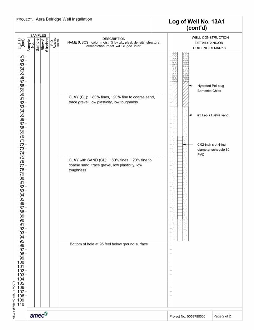
CLAY (CL): ~80% fines, ~20% fine to coarse sand,trace gravel, low plasticity, low toughness
CLAY with SAND (CL): ~80% fines, ~20% fine tocoarse sand, trace gravel, low plasticity, lowtoughness
Bottom of hole at 95 feel below ground surface
Hydrated Pel-plug
Bentonite Chips
#3 Lapis Lustre sand
0.02-inch slot 4-inch
diameter schedule 80
PVC
Log of Well No. 13A1(cont'd)
cementation, react. w/HCl, geo. inter.NAME (USCS): color, moist, % by wt., plast. density, structure,
DESCRIPTION
WE
LL 5
(F
RE
SN
O S
TD
_1-F
OO
T)
DRILLING REMARKS
DETAILS AND/OR
WELL CONSTRUCTIONSAMPLES
DE
PT
H
Sam
ple
(fee
t)
Sam
ple
No.
Blo
ws/
6 in
ches
Rea
ding
(ppm
)
PID
Aera Belridge Well Installation
Page 2 of 2
51525354555657585960616263646566676869707172737475767778798081828384858687888990919293949596979899
100101102103104105106107108109110
Project No. 0053750000
PROJECT: