revised segment 17sccrtc.org/.../2012/10/appendix+i+-revised+segment+17.pdf · 2015-05-05 · •...
TRANSCRIPT

APPENDIX I
Revised Segment 17

I - 2 | R E V I S E D S E G M E N T 1 7

A P P E N D I X I | I - 3
Harkins Slough train trestle
Harkins Slough fauna
Harkins Slough looking south
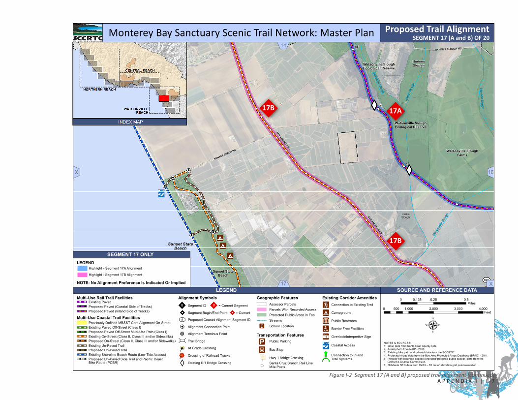
4.17 SEGMENT 17 - HARKINS SLOUGHSegment 17ALength: 4.00 miles (21,140 LF) - Buena Vista Drive and San Andreas Road intersection to Lee Road - cost reflected in table on page 4-94 for planning purposes only.
Segment 17BLength: 3.58 miles (18,920 LF) - Buena Vista Drive and San Andreas Road intersection to Lee Road and rail line intersection via San Andreas Road/West Beach Street/Segment 18A/Lee Road. Segment length does not include Segment 18A length. Segment 17B cost and distance not reflected in project summary table nor total project figures.
4.17.1 SEGMENT 17 BOUNDARY DETERMINATION
Segment 17AThe boundary is determined by the physical setting and the change in rail corridor character from the northern starting point at San Andreas Road down the coast to Harkins Slough, a primary branch of Watsonville Slough. This is the one (1) spot where the rail corridor diverts away from the coastal edge and heads inland as it continues down the coast to Watsonville.
Segment 17BThe boundary is determined by the intersection of the rail line at Buena Vista Drive and San Andreas Road and proceeding downcoast to West Beach Street via existing San Andreas Road on-street facilities and then northeast to the intersection of West Beach Street and Thurwacher Road. The down coast boundary is determined by connecting via Lee Road back to the Segment 18 Coastal Rail Trail.
4.17.2 SEGMENT 17 DESCRIPTION
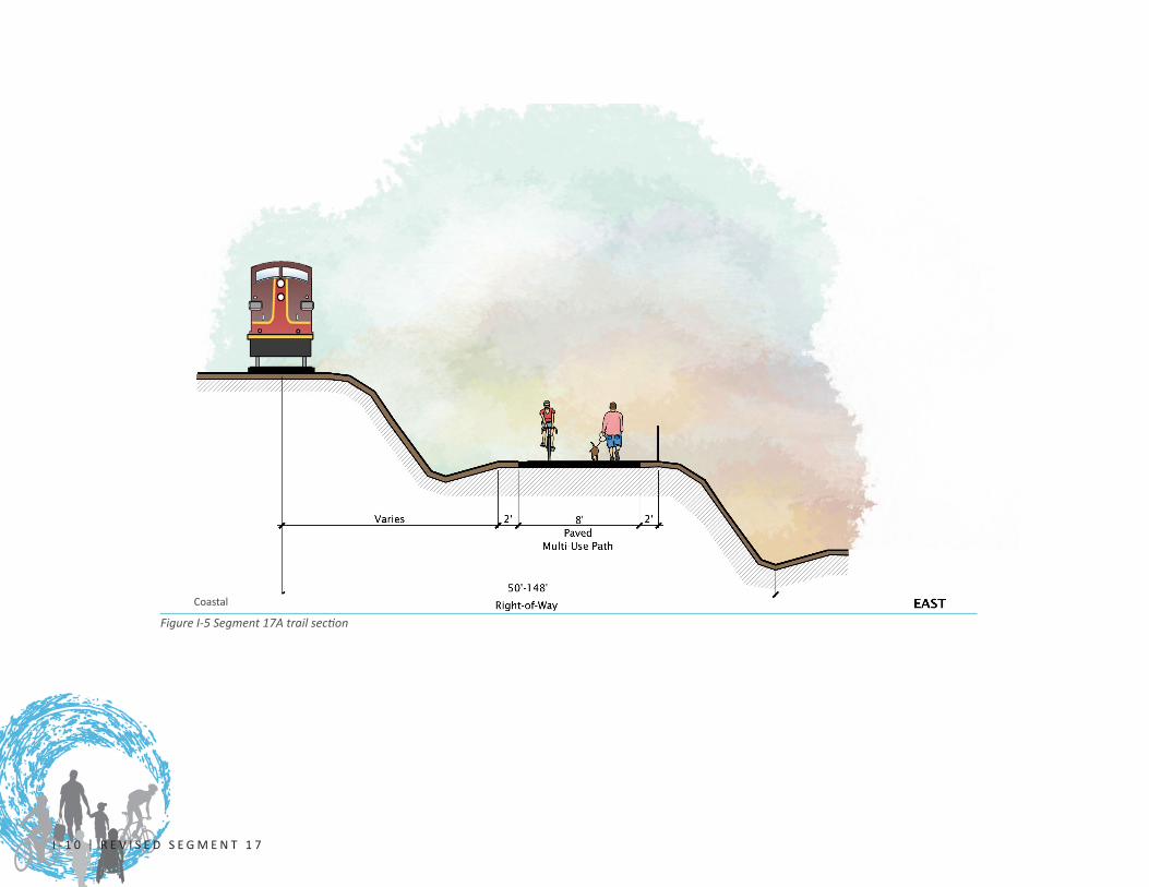
Segment 17AStarting from the intersection crossing at San Andreas Road and Buena Vista Drive, the proposed Coastal Rail Trail will parallel Gallighan Slough to its convergence with Harkins Slough, following the inland side of the rail tracks. The rail right-of-way width varies from forty-five- (45-) feet wide to one-hundred-and-forty-eight- (148-)feet wide as it continues along the steep slope just down the coast from mile marker 7 to mile marker 4.5 at the Harkins Slough trestle. The Segment 17 stretch will require retaining walls to create a bench for the trail tread. This segment is heavily wooded with several smaller rail trestle bridge crossings over small drainages and sloping ravines.
The proposed Coastal Rail Trail will follow the inland rail right-of-way along several agricultural fields, a mineral quarry, and wooded slopes as it descends towards the Gallighan Slough-Harkins Slough wetland area. The alignment will require several preengineered bridges and culverts to cross several of the drainages along the steep slopes. Harkins Slough is the largest freshwater slough in California’s Central Coast region, and the four-hundred- (400-) foot crossing of the slough may require a boardwalk bridge structure adjacent to the rail line to

I - 4 | R E V I S E D S E G M E N T 1 7
reach down the coastal side of the slough. A possible interim alignment will divert the trail from the rail line at Gallighan Slough to an on-road alignment at Rountree Lane, Harkins Slough Road, and Lee Road, and will reconnect with the rail at the Lee Road junction. (This alignment was not evaluated or identified in this Master Plan.) The trail will require fencing along the agricultural operations and there is one (1) private, agricultural, dirt road, non-signalized rail crossing west of Lee Road. This segment connects with four (4) activity centers identified in Table 3.1.
Segment 17A proposed improvements include:
• 4.0 miles (21,140 LF) multi-use paved path (Class I) along the inland rail right-of-way
• Seven (7) rail bridge/culvert crossings of varying lengths
• One (1) private farm road crossing (one-half [1/2] mile west of Lee Road)
• One (1) private road crossing at Buena Vista Drive and one (1) additional private crossing
• This segment also includes fencing for agricultural operations and safety; additional fencing may be considered when project is implemented
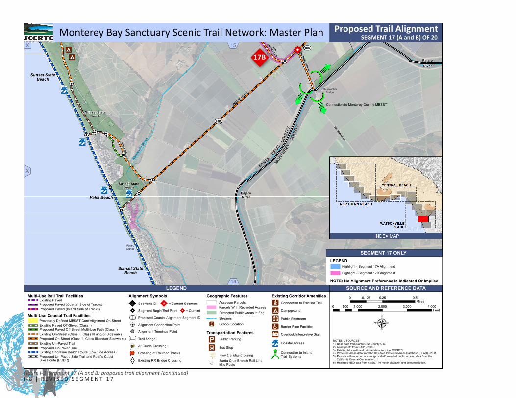
Segment 17BStarting from the intersection crossing at Buena Vista Drive and San Andreas Road, the project would utilize the existing San Andreas Road on-street network to provide connectivity to West Beach Street, then northeast to the intersection of West Beach Street and Thurwacher Road (southwest terminus of Coastal Trail segment 18A). San Andreas Road serves as the Pacific Coast Bicycle Route and connects down coast via West Beach Street and Thurwacher Road to Monterey County.
The Segment 17B alignment will utilize Coastal Trail segment 18A along West Beach Street to reach the intersection of West Beach Street and Lee Road. Segment 17B will continue from this intersection north along Lee Road back to the Rail Trail at the Segment 18 up coast terminus. This portion of Segment 17B will require development of on-street facilities.
Segment 17B proposed improvements include:
• 3.31 miles (17,490 LF) - Improvements to existing bicycle lane (Class II) facilities along San Andreas Road to West Beach Street
• 0.13miles (680 LF) - Improvements to existing bicycle lane (Class II) facilities along West Beach Street to Thurwacher Road
• 0.14 miles (750 LF) - Development of bicycle lane (Class II) facilities along Lee Road to the Rail Trail Segment 18 up coast terminus
Note: Segment 17B improvements are not costed out on page 4-94 nor is the mileage reflected in the total project mileage. Segment 17A improvements are costed out for planning purposes only and are not to indicate an alignment preference.
For Segment 17 there shall be established a joint planning and implementation task force to make recommendations to the RTC and any other implementing agency prior to any trail design, development, or construction activities for this segment. The task force shall consider alternative trail alignments, including those identified in the Final Environmental Impact Report, for Segment 17 and recommend a final alignment. Membership on the task force shall include representation from adjacent property owners recommended by the County Farm Bureau, representation from the disabled community as recommended by the Commission on Disabilities, and representation from the bicycle community.

A P P E N D I X I | I - 5
Existing Watsonville Slough trail
Harkins Slough looking south
Existing Watsonville Slough trail
4.00 miles (21,140 LF) - Harkins SloughRail Trail Portion 4.00 miles (21,140 LF)
Coastal Trail Portion 0.0 miles (0 LF)
$19,961,888
Quantity Unit Unit Price Cost
Paved Multi-Use Path 21,140 Linear Feet Varies $5,212,980
Amenities (Fencing, Benches, Signeage, Etc.) 1 Lump Sum Varies $233,200
Bridge Structures 7 Each Varies $7,000,000
At-Grade Crossings (Rail Tracks or Streets) 3 Each Varies $30,000
Rail Trail Construction SUBTOTAL $12,476,180
Quantity Unit Unit Price Cost
Paved Multi-Use Path 0 Linear Feet Varies $0
Unpaved Trail 0 Linear Feet Varies $0
On Street Facilites (Class II, III, and Sidewalks) 0 Linear Feet Varies $0
Coastal Trail Construction SUBTOTAL $0
Construction TOTAL $12,476,180
$1,871,427
Environmental Permitting (10%) $1,247,618
Construction Management (15%) $1,871,427
Contingency (20%) $2,495,236
$19,961,888
Description Quantity
Segment Jurisdictional Area -
Rail Bridge Crossing (Wood Trestle) 4
Major Drainage 1
Minor Drainage 2
Coastal Trail Components
TABLE 4.17 Segment 17 - Harkins SloughSegment Length
Segment Cost
Rail Trail Components
Various drainages along segment
Watsonville Slough
COST SUMMARY
Design, Engineering, and PS&E (Plans, Specifications, and Estimates) (15%)
SEGMENT TOTAL COST
Segment Features
Various bridges along segment
RTC - Rail ROW Owner, City of Watsonville, California Dept. of Fish and Wildlife (CDFW)
Rail Tr
ail porti
on coste
d for p
lanning p
urposes only
and not to
imply
priorit
y ove
r other p
ossible al
ignments.

I - 6 | R E V I S E D S E G M E N T 1 7
Sand DollarSand DollarDevelopmentDevelopment
La SelvaLa SelvaBeachBeach
Manresa StateManresa StateBeachBeach
Manresa StateManresa StateBeachBeach
Manresa StateManresa StateBeachBeach
1
1
1
1
1
CDFG
Watsonville SloughEcological Reserve
Santa CruzLong-Toed Salamander
Ecological Reserve
Ellicott SloughNational Wildlife
Refuge
GallighanSlough
GallighanSlough
HarkinsSlough
Watsonville SloughEcological Reserve
Watsonville SloughEcological Reserve
StruveSlough
StruveSlough
Watsonville SloughFarms
Watsonville SloughFarms
Watsonville SloughEcological Reserve
StruveSlough
Sunset StateBeach
SUMNER AV
SUMNER AV
Hidden BeachHidden BeachAccessAccess
Sumner AveSumner AveBeach AccessBeach Access
Seascape PublicSeascape PublicTrailsTrails
Manresa StateManresa StateBeach TrailsBeach Trails
WEST BEACH ST
WEST BEACH ST
LEE RD
LEE RD
SAN ANDREAS RD
SAN ANDREAS RD
SAN
AN
DREA
S RD
SAN
AN
DREA
S RD
SAN ANDREAS RD
SAN ANDREAS RD
SAN
AN
DREA
S RD
SAN
AN
DREA
S RD
DOLPHIN DR
DOLPHIN DR
LAR
KIN
VA
LLEY
RD
LAR
KIN
VA
LLEY
RD
PALO ALTO
PALO ALTO
VIAVIA
SPRING VALLEY RDSPRING VALLEY RD
CAMINO AL MAR
CAMINO AL MAR
16B
16A
18A
18A
SUNSET BEACH RD
SUNSET BEACH RD
SeascapeSeascapeGolf ClubGolf Club
Polo Fields
SeascapeSeascapeGolf ClubGolf Club
Ellicott SloughNational Wildlife
Area
Long-ToedSalamanderEcological
Reserve
Place de MerPark
Ellicott SloughNational Wildlife
Refuge
Manresa State BeachManresa State BeachCampgroundsCampgrounds
HarkinsSlough
HarkinsSlough Ellicott Slough
National WildlifeRefuge
Undercrossing atUndercrossing atState Hwy BridgeState Hwy Bridge
J
Rio Del MarBeach
70
75
Locked Gate
77
J
17A
17A17B
17A
17B
17B
SAN ANDREAS RD
SAN ANDREAS RD
BUENA VISTA DR
BUENA VISTA DR
FREEDOM BL
FREEDOM BL
AMESTI RD
AMESTI RD
SAN ANDREAS RD
SAN ANDREAS RD
LARKIN VALLEY RD
LARKIN VALLEY RD
LEE RDLEE RD
BUENA VISTA DRBUENA VISTA DR
SUMNER AV
SUMNER AV
AIRPORT BL
AIRPORT BL
BONITA DR
BONITA DR
HARKINS SLOUGH RDHARKINS SLOUGH RD
MAR
MON
TE A
V
MAR
MON
TE A
V
DOLPHIN DR
DOLPHIN DR
SOUT
H G
REEN
VAL
LEY
RD
SOUT
H G
REEN
VAL
LEY
RD
SEASCAPE BLSEASCAPE BL
PINEHURST DR
PINEHURST DR
ESTRELLA AV
ESTRELLA AV
EAST TOWNSEND DR
EAST TOWNSEND DR
CLIFF DR
CLIFF DR
LOMA PRIETA AV
LOMA PRIETA AV
Gal
ligha
n S
loug
hG
allig
han
Slo
ugh
7
8
9
6
8.5
7.5
6.5
14 X
X
12 X
School Location!,!
"!
Segment ID
Segment Begin/End Point
Proposed Coastal Alignment Segment ID
Alignment Connection Point
Trail Bridge
At Grade Crossing
Crossing of Railroad Tracks
â³³
ØØ"" Connection to Inland
Existing RR Bridge Crossing
Geographic FeaturesConnection to Existing TrailAssessor Parcels
Parcels With Recorded Access
Transportation Features
Hwy 1 Bridge Crossing
Bus Stop
Public Parking
Campground
Public Restroom
Barrier Free Facilities
Coastal Access
Existing Corridor Amenities
Protected Public Areas in Fee
Alignment Symbols
XY
Streams
Overlook/Interpretive Sign!\
K""(
µ
0 0.25 0.50.125Miles
0 1,000 2,000 3,000 4,000500Feet
!i"5
nÆå
"#
öõ#
Alignment Terminus Point
¾Ü
!b!_!9
Trail Systems
= Current
= Current Segment
"!"#
Proposed Trail Alignment
K«
LEGEND
Monterey Bay Sanctuary Scenic Trail Network: Master Plan
NOTES & SOURCES: 1) Base data from Santa Cruz County GIS. 2) Aerial photo from NAIP - 2009. 3) Existing bike path and railroad data from the SCCRTC. 4) Protected Areas data from the Bay Area Protected Areas Database (BPAD) - 2011. 5) Parcels with recorded access (provided/protected public access) data from the California Coastal Commission. 6) Hillshade NED data from CaSIL - 10 meter elevation grid point resolution.Santa Cruz Branch Rail Line
Mile Posts
Multi-Use Rail Trail FacilitiesExisting PavedProposed Paved (Coastal Side of Tracks)Proposed Paved (Inland Side of Tracks)
Existing On-Street (Class II, Class III and/or Sidewalks)Proposed On-Street (Class II, Class III and/or Sidewalks)
Proposed Un-Paved Side Trail and Pacific Coast
Existing Un-Paved TrailProposed Un-Paved TrailExisting Shoreline Beach Route (Low Tide Access)
Multi-Use Coastal Trail Facilities
Existing Paved Off-Street (Class I)Proposed Paved Off-Street Multi-Use Path (Class I)
Previously Defined MBSST Core Alignment On-Street
Bike Route (PCBR)
XSOURCE AND REFERENCE DATA
XNOTE: No Alignment Preference Is Indicated Or Implied
Highlight - Segment 17B Alignment
Highlight - Segment 17A AlignmentLEGEND
SEGMENT 17 ONLY
Figure I-1 Segment 17 (A and B) proposed trail alignment
17A
17B
SEGMENT 17 (A and B) OF 20
A P P E N D I X I | I - 7
HarkinHarkinSloughSlough
Sunset StateSunset StateBeachBeach
1
1
1
MONTEREY
CRUZ
SANTA
COUN
TY
MONT
EREY
1
Watsonville SloughEcological Reserve
Santa CruzLong-Toed Salamander
Ecological Reserve
Ellicott SloughNational Wildlife
Refuge
GallighanSlough
GallighanSlough
HarkinsSlough
Watsonville SloughEcological Reserve
Watsonville SloughEcological Reserve
StruveSlough
StruveSlough
Watsonville SloughFarms
Watsonville SloughFarms
Watsonville SloughEcological Reserve
StruveSlough
Neary LagoonPark
Sunset StateBeach
Sunset StateBeach
Sunset StateBeach
Manresa StateManresa StateBeach TrailsBeach Trails
WEST BEACH ST
WEST BEACH ST
WEST BEACH ST
WEST BEACH ST
LEE RD
LEE RD
WEST BEACH ST
WEST BEACH ST
SHELL DRSHELL DR
SAN ANDREAS RD
SAN ANDREAS RD
SAN
AN
DREA
S RD
SAN
AN
DREA
S RD
SAN ANDREAS RD
SAN ANDREAS RD
PajaroRiver
SPRING VALLEY RDSPRING VALLEY RD
16B
16A
18A
18A
18A
18B
SUNSET BEACH RD
SUNSET BEACH RD
Polo Fields
SeascapeSeascapeGolf ClubGolf Club
Place de MerPark
Ellicott SloughNational Wildlife
Refuge
Manresa State BeachManresa State BeachCampgroundsCampgrounds
HarkinsSlough
HarkinsSlough Ellicott Slough
National WildlifeRefuge
SeaviewPark
RIVERSIDE DR
RIVERSIDE DR
HARVEST DR
HARVEST DR
2ND ST
2ND ST
OH
LON
E PKW
YO
HLO
NE PK
WY
Undercrossing atUndercrossing atState Hwy BridgeState Hwy Bridge
PajaroRiver
PajaroRiver
SANSAN
ANDREAS RD
ANDREAS RD
Connection to Monterey County MBSST
MCGOWAN RD
MCGOWAN RDCO
UNTY
J
77
17B
17A
17A17B
17A
17B
17B
17B
LEE RDLEE RD
SAN ANDREAS RD
SAN ANDREAS RD
BUENA VISTA DR
BUENA VISTA DR
THURWACHER RD
THURWACHER RD
SAN ANDREAS RD
SAN ANDREAS RD
MAIN STMAIN ST
LEE RDLEE RD
AIRPORT BL
AIRPORT BL
HARKINS SLOUGH RDHARKINS SLOUGH RD
HOLOHAN RD
HOLOHAN RD
WEST RIVERSIDE DR
WEST RIVERSIDE DR
SOUT
H G
REEN
VAL
LEY
RD
SOUT
H G
REEN
VAL
LEY
RD
INDUSTRIAL RD
INDUSTRIAL RD
ESTRELLA AV
ESTRELLA AV
WEST LAKE AV
WEST LAKE AVWALKER ST
WALKER ST
LOMA PRIETA AV
LOMA PRIETA AV
Har
kin
Slou
gh
Har
kin
Slou
gh
Wat
sonv
ille S
loug
h
Wat
sonv
ille S
loug
h
Hanson S
loughH
anson Slough
Gallighan Slough
Gallighan Slough
5
4
5.5
4.5
16 X
17
1413
School Location!,!
"!
Segment ID
Segment Begin/End Point
Proposed Coastal Alignment Segment ID
Alignment Connection Point
Trail Bridge
At Grade Crossing
Crossing of Railroad Tracks
â³³
ØØ"" Connection to Inland
Existing RR Bridge Crossing
Geographic FeaturesConnection to Existing TrailAssessor Parcels
Parcels With Recorded Access
Transportation Features
Hwy 1 Bridge Crossing
Bus Stop
Public Parking
Campground
Public Restroom
Barrier Free Facilities
Coastal Access
Existing Corridor Amenities
Protected Public Areas in Fee
Alignment Symbols
XY
Streams
Overlook/Interpretive Sign!\
K""(
µ
0 0.25 0.50.125Miles
0 1,000 2,000 3,000 4,000500Feet
!i"5
nÆå
"#
öõ#
Alignment Terminus Point
¾Ü
!b!_!9
Trail Systems
= Current
= Current Segment
"!"#
Proposed Trail Alignment
K«
LEGEND
Monterey Bay Sanctuary Scenic Trail Network: Master Plan
NOTES & SOURCES: 1) Base data from Santa Cruz County GIS. 2) Aerial photo from NAIP - 2009. 3) Existing bike path and railroad data from the SCCRTC. 4) Protected Areas data from the Bay Area Protected Areas Database (BPAD) - 2011. 5) Parcels with recorded access (provided/protected public access) data from the California Coastal Commission. 6) Hillshade NED data from CaSIL - 10 meter elevation grid point resolution.Santa Cruz Branch Rail Line
Mile Posts
Multi-Use Rail Trail FacilitiesExisting PavedProposed Paved (Coastal Side of Tracks)Proposed Paved (Inland Side of Tracks)
Existing On-Street (Class II, Class III and/or Sidewalks)Proposed On-Street (Class II, Class III and/or Sidewalks)
Proposed Un-Paved Side Trail and Pacific Coast
Existing Un-Paved TrailProposed Un-Paved TrailExisting Shoreline Beach Route (Low Tide Access)
Multi-Use Coastal Trail Facilities
Existing Paved Off-Street (Class I)Proposed Paved Off-Street Multi-Use Path (Class I)
Previously Defined MBSST Core Alignment On-Street
Bike Route (PCBR)
XSOURCE AND REFERENCE DATA
XNOTE: No Alignment Preference Is Indicated Or Implied
Highlight - Segment 17B Alignment
Highlight - Segment 17A AlignmentLEGEND
SEGMENT 17 ONLY
Figure I-2 Segment 17 (A and B) proposed trail alignment (continued)
17B
17B
17A
SEGMENT 17 (A and B) OF 20
I - 8 | R E V I S E D S E G M E N T 1 7
Inland
PajaroPajaroDunesDunes
ThurwacherThurwacherBridgeBridge
Sunset StateSunset StateBeachBeach
Palm BeachPalm Beach
Sunset StateSunset StateBeachBeach
1
CO
UN
TY
MONTEREY
CRUZ
SANTA
COUN
TY
MONT
EREY
1
HarkinsSlough
Watsonville SloughEcological Reserve
Watsonville SloughEcological Reserve
Watsonville SloughFarms
Watsonville SloughFarms
Watsonville SloughEcological Reserve
StruveSlough
Sunset StateBeach
Sunset StateBeach
Sunset StateBeach
Sunset StateBeach
LeveeLeveePathPath
WEST BEACH ST
WEST BEACH ST
MAIN ST
MAIN ST
WEST BEACH ST
WEST BEACH ST
LEE RD
LEE RD
WEST BEACH ST
WEST BEACH ST
SHELL DRSHELL DR
SAN ANDREAS RD
SAN ANDREAS RD
CO
UN
TY
PajaroRiver
18A
18A
18A
18B
To Monterey
SUNSET BEACH RD
SUNSET BEACH RD
Polo Fields
SeascapeSeascapeGolf ClubGolf Club
SeaviewPark
WatsonvilleWatsonvilleJunctionJunction
MarinovichPark
RIVERSIDE DR
RIVERSIDE DR
HARVEST DR
HARVEST DR
2ND ST
2ND ST
RODRIGUEZ ST
RODRIGUEZ ST
OH
LON
E PKW
YO
HLO
NE PK
WY
Undercrossing atUndercrossing atState Hwy BridgeState Hwy Bridge
PajaroRiver
Undercrossing atUndercrossing atState Hwy BridgeState Hwy Bridge
LEWIS RDLEWIS RD
RAILROAD AVERAILROAD AVE
SALIN
AS R
DSA
LINA
S RD
SALIN
AS R
DSA
LINA
S RD
SAN JUAN RDSAN JUAN RD
PajaroRiver
SANSAN
ANDREAS RD
ANDREAS RD
Connection to Monterey County MBSST
MCGOWAN RD
MCGOWAN RD
19A
CRUZ
SANTA
COUNTY
MONTEREY COUNTY
PajaroRiver
COUN
TY
J
17B
17A
17A17B
17B
17B
LEE RDLEE RD
SAN ANDREAS RD
SAN ANDREAS RD
THURWACHER RD
THURWACHER RD
LEE RDLEE RD
HARKINS SLOUGH RDHARKINS SLOUGH RD
WEST RIVERSIDE DR
WEST RIVERSIDE DR
EAST BEACH ST
EAST BEACH ST
RIVERSIDE DR
RIVERSIDE DR
INDUSTRIAL RD
INDUSTRIAL RD
WEST LAKE AV
WEST LAKE AVWALKER ST
WALKER ST
Pajaro river
Pajaro river
Wat
sonv
ille S
lough
Wat
sonv
ille S
lough
X X
18
15 X
School Location!,!
"!
Segment ID
Segment Begin/End Point
Proposed Coastal Alignment Segment ID
Alignment Connection Point
Trail Bridge
At Grade Crossing
Crossing of Railroad Tracks
â³³
ØØ"" Connection to Inland
Existing RR Bridge Crossing
Geographic FeaturesConnection to Existing TrailAssessor Parcels
Parcels With Recorded Access
Transportation Features
Hwy 1 Bridge Crossing
Bus Stop
Public Parking
Campground
Public Restroom
Barrier Free Facilities
Coastal Access
Existing Corridor Amenities
Protected Public Areas in Fee
Alignment Symbols
XY
Streams
Overlook/Interpretive Sign!\
K""(
µ
0 0.25 0.50.125Miles
0 1,000 2,000 3,000 4,000500Feet
!i"5
nÆå
"#
öõ#
Alignment Terminus Point
¾Ü
!b!_!9
Trail Systems
= Current
= Current Segment
"!"#
Proposed Trail Alignment
K«
LEGEND
Monterey Bay Sanctuary Scenic Trail Network: Master Plan
NOTES & SOURCES: 1) Base data from Santa Cruz County GIS. 2) Aerial photo from NAIP - 2009. 3) Existing bike path and railroad data from the SCCRTC. 4) Protected Areas data from the Bay Area Protected Areas Database (BPAD) - 2011. 5) Parcels with recorded access (provided/protected public access) data from the California Coastal Commission. 6) Hillshade NED data from CaSIL - 10 meter elevation grid point resolution.Santa Cruz Branch Rail Line
Mile Posts
Multi-Use Rail Trail FacilitiesExisting PavedProposed Paved (Coastal Side of Tracks)Proposed Paved (Inland Side of Tracks)
Existing On-Street (Class II, Class III and/or Sidewalks)Proposed On-Street (Class II, Class III and/or Sidewalks)
Proposed Un-Paved Side Trail and Pacific Coast
Existing Un-Paved TrailProposed Un-Paved TrailExisting Shoreline Beach Route (Low Tide Access)
Multi-Use Coastal Trail Facilities
Existing Paved Off-Street (Class I)Proposed Paved Off-Street Multi-Use Path (Class I)
Previously Defined MBSST Core Alignment On-Street
Bike Route (PCBR)
16SOURCE AND REFERENCE DATA
XNOTE: No Alignment Preference Is Indicated Or Implied
Highlight - Segment 17B Alignment
Highlight - Segment 17A AlignmentLEGEND
SEGMENT 17 ONLY
Figure I-3 Segment 17 (A and B) proposed trail alignment (continued)
SEGMENT 17 (A and B) OF 20
17B

A P P E N D I X I | I - 9
WatsonvilleWatsonvilleSloughSlough
SANTA
CRUZ
1
1
1
CO
UN
TY
MONTEREY
CRUZ
SANTA
COUN
TY
MONT
EREY
1
GallighanSlough
GallighanSlough
HarkinsSlough
Watsonville SloughEcological Reserve
Watsonville SloughEcological Reserve
StruveSlough
StruveSlough
Watsonville SloughFarms
Watsonville SloughFarms
Watsonville SloughEcological Reserve
StruveSlough
Neary LagoonPark
Sunset StateBeach
Sunset StateBeach
WEST BEACH ST
WEST BEACH ST
MAIN ST
MAIN ST
WEST BEACH ST
WEST BEACH ST
LEE RD
LEE RD
WEST BEACH ST
WEST BEACH ST
SHELL DRSHELL DR
SAN ANDREAS RD
SAN ANDREAS RD
CO
UN
TY
PajaroRiver
18A
18A
18A
18B Polo Fields
SeascapeSeascapeGolf ClubGolf Club
HarkinsSlough
HarkinsSlough Ellicott Slough
National WildlifeRefuge
SeaviewPark
WatsonvilleWatsonvilleJunctionJunction
MarinovichPark
RIVERSIDE DR
RIVERSIDE DR
HARVEST DR
HARVEST DR
2ND ST
2ND ST
RODRIGUEZ ST
RODRIGUEZ ST
OH
LON
E PKW
YO
HLO
NE PK
WY
Undercrossing atUndercrossing atState Hwy BridgeState Hwy Bridge
PajaroRiver
LEWIS RDLEWIS RD
RAILROAD AVERAILROAD AVE
SALIN
AS R
DSA
LINA
S RD
SALIN
AS R
DSA
LINA
S RD
SAN JUAN RDSAN JUAN RD
PajaroRiver
SANSAN
ANDREAS RD
ANDREAS RD
Connection to Monterey County MBSST
MCGOWAN RD
MCGOWAN RD
19A
COUN
TY
J
17B
17A
17A17B
17A
17B
17B
LEE RDLEE RD
SAN ANDREAS RD
SAN ANDREAS RD
THURWACHER RD
THURWACHER RD
MAIN STMAIN ST
LEE RDLEE RD
AIRPORT BL
AIRPORT BL
HARKINS SLOUGH RDHARKINS SLOUGH RD
HOLOHAN RD
HOLOHAN RD
WEST RIVERSIDE DR
WEST RIVERSIDE DR
SOUT
H G
REEN
VAL
LEY
RD
SOUT
H G
REEN
VAL
LEY
RD
EAST LAKE AV
EAST LAKE AV
EAST BEACH ST
EAST BEACH ST
RIVERSIDE DR
RIVERSIDE DR
INDUSTRIAL RD
INDUSTRIAL RD
WEST LAKE AV
WEST LAKE AVWALKER ST
WALKER ST
LOMA PRIETA AV
LOMA PRIETA AV
Paj
aro
river
Paj
aro
river
Watsonville Slough
Watsonville Slough
Stru
ve S
lough
Stru
ve S
lough
Hanson Slough
Hanson Slough
2
3
1
1.5
2.5
3.50.5
X15
X
X14
School Location!,!
"!
Segment ID
Segment Begin/End Point
Proposed Coastal Alignment Segment ID
Alignment Connection Point
Trail Bridge
At Grade Crossing
Crossing of Railroad Tracks
â³³
ØØ"" Connection to Inland
Existing RR Bridge Crossing
Geographic FeaturesConnection to Existing TrailAssessor Parcels
Parcels With Recorded Access
Transportation Features
Hwy 1 Bridge Crossing
Bus Stop
Public Parking
Campground
Public Restroom
Barrier Free Facilities
Coastal Access
Existing Corridor Amenities
Protected Public Areas in Fee
Alignment Symbols
XY
Streams
Overlook/Interpretive Sign!\
K""(
µ
0 0.25 0.50.125Miles
0 1,000 2,000 3,000 4,000500Feet
!i"5
nÆå
"#
öõ#
Alignment Terminus Point
¾Ü
!b!_!9
Trail Systems
= Current
= Current Segment
"!"#
Proposed Trail Alignment
K«
LEGEND
Monterey Bay Sanctuary Scenic Trail Network: Master Plan
NOTES & SOURCES: 1) Base data from Santa Cruz County GIS. 2) Aerial photo from NAIP - 2009. 3) Existing bike path and railroad data from the SCCRTC. 4) Protected Areas data from the Bay Area Protected Areas Database (BPAD) - 2011. 5) Parcels with recorded access (provided/protected public access) data from the California Coastal Commission. 6) Hillshade NED data from CaSIL - 10 meter elevation grid point resolution.Santa Cruz Branch Rail Line
Mile Posts
Multi-Use Rail Trail FacilitiesExisting PavedProposed Paved (Coastal Side of Tracks)Proposed Paved (Inland Side of Tracks)
Existing On-Street (Class II, Class III and/or Sidewalks)Proposed On-Street (Class II, Class III and/or Sidewalks)
Proposed Un-Paved Side Trail and Pacific Coast
Existing Un-Paved TrailProposed Un-Paved TrailExisting Shoreline Beach Route (Low Tide Access)
Multi-Use Coastal Trail Facilities
Existing Paved Off-Street (Class I)Proposed Paved Off-Street Multi-Use Path (Class I)
Previously Defined MBSST Core Alignment On-Street
Bike Route (PCBR)
XSOURCE AND REFERENCE DATA
17NOTE: No Alignment Preference Is Indicated Or Implied
Highlight - Segment 17B Alignment
Highlight - Segment 17A AlignmentLEGEND
SEGMENT 17 ONLY
Figure I-4 Segment 17 (A and B) proposed trail alignment (continued)
SEGMENT 17 (A and B) OF 20
17A17B
I - 1 0 | R E V I S E D S E G M E N T 1 7
Coastal
Figure I-5 Segment 17A trail section