revised study plan - brainerd public...
TRANSCRIPT


Distribution List

Federal Agencies Advisory Council on Historic Preservation John M. Fowler, Executive Director Old Post Office Building 1100 Pennsylvania Ave NW Suite 803 Washington DC 20004 [email protected]
U.S. National Park Service Randy Thoreson, Recreation Planner 111 East Kellogg Blvd Suite 105 St Paul MN 55101 [email protected]
U.S. Bureau of Indian Affairs Diane Rosen, Director, Midwest Regional Office 5600 American Boulevard West Suite 500 Bloomington MN 55437-1274 [email protected]
U.S. Senator Office of Senator Smith 309 Hart Senate Office Building Washington DC 20510 No email address available
Federal Emergency MGMT Agency Brock Long, Administrator 500 C Street SW Washington DC 20472 [email protected]
U.S. Senator Office of Senator Klobuchar 309 Hart Senate Office Building Washington DC 20510 No email address available
Federal Energy Regulatory Commission John Zygaj, Regional Engineer Division of Dam Safety and Inspections 230 South Dearborn Street Room 3130 Chicago IL 60604 [email protected]
U.S. Army Corps of Engineers, St. Paul District Robert K. Edstrom, Project Manager 190 5th St. East St. Paul MN 55101-1638 [email protected]
Federal Energy Regulatory Commission Patrick C. Ely, Fisheries Biologist Office of Energy Projects Division of Hydropower Licensing 888 First Street, NE Washington DC 20426 [email protected]
U.S. Bureau of Land Management, Eastern States State Office Mitchell Leverette, Acting State Director 20 M Street SE Suite 950 Washington DC 20003 [email protected]
Federal Energy Regulatory Commission Shana Wiseman Office of Energy Projects Division of Hydropower Licensing [email protected]
U.S. Bureau of Reclamation Brenda Burman, Commissioner U.S. Department of the Interior 1849 C Street NW Washington DC 20240-0001 [email protected]
National Oceanic and Atmospheric Administration Fisheries Regional Office Michael Pentony, Regional Administrator 55 Great Republic Drive Gloucester MA 01930-2298 [email protected]
U.S. Coast Guard CAPT. Mary Ellen Durley Chief Office of Navigation Systems 2703 Martin Luther King Jr. Ave SE Washington DC 20593-7000 [email protected]
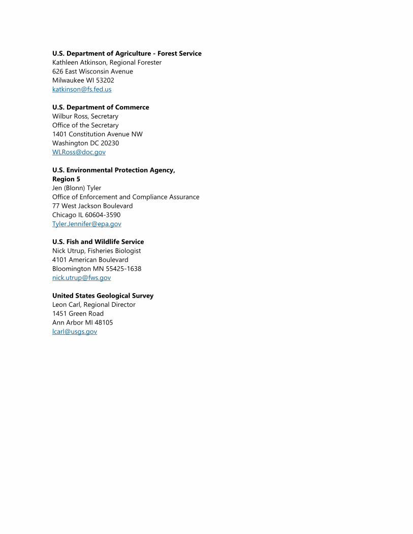
U.S. Department of Agriculture - Forest Service Kathleen Atkinson, Regional Forester 626 East Wisconsin Avenue Milwaukee WI 53202 [email protected]
U.S. Department of Commerce Wilbur Ross, Secretary Office of the Secretary 1401 Constitution Avenue NW Washington DC 20230 [email protected]
U.S. Environmental Protection Agency, Region 5 Jen (Blonn) Tyler Office of Enforcement and Compliance Assurance 77 West Jackson Boulevard Chicago IL 60604-3590 [email protected]
U.S. Fish and Wildlife Service Nick Utrup, Fisheries Biologist 4101 American Boulevard Bloomington MN 55425-1638 [email protected]
United States Geological Survey Leon Carl, Regional Director 1451 Green Road Ann Arbor MI 48105 [email protected]

Non-Government Organizations American Canoe Association Wade Blackwood, Executive Director 1340 Central Blvd Suite 210 Fredericksburg VA 22401 [email protected]
American Rivers William Robert Irvin, President 1101 14th St. NW Suite 1400 Washington DC 20005-5637 [email protected]
Hydropower Reform Coalition National Coordinator 1101 14th St. NW Suite 1400 Washington DC 20005-5637 [email protected]
Trout Unlimited Chris Wood, President/ Chief Executive Officer 1777 N. Kent Street Suite 100 Arlington, VA 22209 [email protected]

State Agencies Minnesota Department of Natural Resources Charlotte Cohn, Hydropower Projects Planner 500 Layfayette Road Eco Resources - Box 25 St. Paul MN 55155-4025 [email protected]
Minnesota Board of Water & Soil Resources John Jaschke, Executive Director 520 Layfayette Road North St. Paul MN 55155-0001 [email protected]
Minnesota Pollution Control Agency - North Central Region Laurel Mezner, Watershed Unit Supervisor 7678 College Road, Suite 105 Baxter, MN 56425 [email protected]
Minesota Indian Affairs Council Dennis Olson Jr., Executive Director 161 St. Anthony Ave Suite 919 St. Paul MN 55103 [email protected]
Minnesota Historical Society Sarah J. Beimers, SHPO 50 Sherbune Avenue St. Paul MN 55155 [email protected]
Minnesota Public Utilities Commission Daniel P. Wolf, Executive Secretary 121 7th Pl. East Suite 350 St. Paul MN 55101-2163 [email protected]
Office of the Attorney General Lori Swanson, Attorney General State Capitol Suite 102 St. Paul MN 55155 [email protected]
Office of the Governor Governor Mark Dayton 130 State Capitol 75 Rev. Dr. Martin Luther King Jr. Boulevard St. Paul MN 55155 [email protected]
Minnesota Geological Survey Harvey Thorleifson, Director, Midwest Regional Office 2609 West Territorial Road St. Paul MN 55114-1032 [email protected]

Local Government City of Brainerd Paul Sandy, City Engineer 501 Laurel Street Brainerd, MN 56401 [email protected]
City of Baxter 13190 Memorywood Drive Baxter, MN 56425 [email protected]
Crow Wing County Government Timothy Houle, County Administrator 326 Laurel St. Suite 13 Brainerd, MN 56401 [email protected]
Crow Wing Soil & Water Conservation District Melissa Barrick, Manager 322 Laurel St. #22 Brainerd, MN 56401 [email protected]
Township of Center Linda McCabe, Chairwomen 22894 Antler Road Merrfield, MN 56465 No email address available
Township of Irondale 19121 County Road 12 Ironton, MN 56455 No email address available
Township of Oak Lawn Sharon Pike, Supervisor Chair P.O. Box 333 Brainerd, MN 56401 [email protected]
Township of West Crow Wing Greg Smith, Chairman 6930 Cuyuna Avenue [email protected]

Native American Tribes Bois Forte Band of Chippewa Bill Latady, Tribal Historic Preservation Officer 5344 Lakeshore Drive PO Box 16 Nett Lake MN 59772 [email protected]
Minnesota Chippewa Tribe Michael Northbird, GAP Coordinator P.O. Box 217 Cass Lake MN 56633 [email protected]
Cheyenne & Arapaho Tribes Virginia Richey, THPO PO Box 167 Concho OK 73022 [email protected]
Otoe-Missouria Tribal Council John R. Shotton, Chairman 8151 Highway 177 Red Rock OK 74651-0348 [email protected]
Fond du Lac Reservation Business Committee Kevin R. Dupuis, Chairman 1720 Big Lake Road Cloquet MN 55720 [email protected]
Ote-Missouria Tribe of Oklahoma Elsie Whitehorn, THPO 8151 Highway 177 Red Rock OK 74651-0348 [email protected]
Grand Portage Reservation Tribal Council Norman Deschampe, Chairman P.O. Box 428 Grand Portage MN 55605 [email protected]
Prairie Island Indian Community of Minnesota Noah White, Tribal Historic Preservation Officer 5636 Sturgeon Lake Road Welch MN 55089 [email protected]
Leech Lake Historic Preservation Office Amy Burnette, Tribal Historic Preservation Officer 190 Sailstar Drive NE Cass Lake MN 56633 [email protected]
Red Lake Band of Chippewa Indians of Minnesota Kade Farris PO Box 274 Red Lake MN 56671 [email protected]
Lower Sioux Indian Community of Minnesota Cheyanne St. John, Tribal Historic Preservation Officer/ Historic Site Mgr. 39527 Reservation Highway 1 Morton MN 56270 [email protected]
Red Lake Nation Government Center Darrell G. Seki, Sr., Chairman 15484 Migizi Drive Red Lake MN 56671 No email address available
Mille Lacs Band of Ojibwe Indians Natalie Weyaus, Tribal Historic Preservation Officer 43408 Oodena Drive Onamia MN 56359 [email protected]
Santee Sioux Tribal Council Roger Trudell, Chairman 425 Frazier Ave. N. Ste 2 Niobrara NE 68760-7219 [email protected]

Santee Sioux Tribal Nation Duane Whipple, THPO 425 Frazier Ave. N. Ste 2 Niobrara NE 68760-7219 No email address available
Shakopee Mdewakanton Sioux Community of Minnesota Bill Rudnicki, Tribal Administrator 2330 Sioux Trail NW Prior Lake MN 55372 [email protected]
Shakopee Mdewakanton Sioux Community of Minnesota Leonard Wabasha, Cultural Resources 2330 Sioux Trail NW Prior Lake MN 55372 [email protected]
Upper Sioux Community of Minnesota Samanatha Odegard, THPO P.O. Box 147 Granite Falls MN 56241-0147 [email protected]
White Earth Nation Terrence Tibbetts, Chairman P.O. Box 418 White Earth MN 56591 [email protected]
White Earth Nation of Minnesota Chippewa Jamie Arsenault, THPO P.O Box 418 White Earth MN 56591 [email protected]

Revised Study Plan

Revised Study Plan
Brainerd Hydroelectric Project
FERC License No. 2533
Prepared for:
Brainerd Public Utilities
Brainerd, Minnesota
December 10, 2018
Available for Public Release

4300 MarketPointe Drive, Suite 200
Minneapolis, MN 55435
Phone: 952.832.2600
Revised Study Plan
Brainerd Hydroelectric Project
FERC License No. 2533
Prepared for:
Brainerd Public Utilities
Brainerd, Minnesota
December 10, 2018
Available for Public Release 1001 Diamond Ridge, Suite 1100
Jefferson City, MO 65109
Phone: 573.638.5000

\\barr.com\projects\Mpls\23 MN\18\23181016 BPU Due Diligence\WorkFiles\05-8_FERC Relicensing\608_Revised Study Plan\BPU Revised Study
Plan_v2.docx
i
Revised Study Plan
Brainerd Hydroelectric Project
December 10, 2018
Preface
The Revised Study Plan (RSP) for the Brainerd Hydroelectric Project (Project) submitted by Brainerd Public
Utilities (BPU) to the Federal Energy Regulatory Commission (FERC) during the Integrated Licensing
Process (ILP) is presented herein.
BPU filed a Pre-Application Document (PAD) and Notice of Intent (NOI) for a license for the Project on
February 28, 2018. The PAD provides a detailed description of the Project and serves as the foundation for
issue identification, study plan development, and the FERC’s environmental analysis. Following the filing of
the PAD, FERC prepared and issued Scoping Document 1 (SD1) on April 26, 2018. FERC also held agency
and public scoping meetings and a site visit on May 16 and 17, 2018. Public agencies and interested
parties were able to file comments on the PAD and SD1 and request studies until June 28, 2018. Within 45
days of the comment period for the PAD closing, BPU was required to prepare and file a PSP, which
addressed each of the study criteria, explained how the proposed studies addresses the issues raised
during scoping, and filled information gaps identified by the stakeholders. Comments generated by the
agencies and interested parties were incorporated into the development of the PSP. Comments on BPU’s
PSP had to be filed within 90 days of filing the PSP, or by November 10, 2018. Comments received on the
PSP were reviewed and considered in development of BPU’s Revised Study Plan (RSP).

ii
Revised Study Plan
Brainerd Hydroelectric Project
December 10, 2018
Contents
1.0 Introduction ................................................................................................................................................................... 1
1.1 Pre-Application Document Background ................................................................................................................ 1
1.2 Proposed Study Plan ..................................................................................................................................................... 1
1.3 Initial Study Plan Meeting ........................................................................................................................................... 2
1.4 Revised Study Plan ......................................................................................................................................................... 2
2.0 Proposed Study Plan Comments and Responses ........................................................................................... 3
3.0 Study Plan Proposals .................................................................................................................................................. 5
3.1 Dissolved Oxygen and Temperature Study .......................................................................................................... 5
3.2 Cultural Resources Study ............................................................................................................................................. 7
3.3 Desktop Fish Entrainment and Impingement Study .......................................................................................10
3.4 Recreation Use and Inventory Planning Study..................................................................................................13
4.0 Anticipated Study Schedule ..................................................................................................................................17
5.0 References ....................................................................................................................................................................18
List of Tables
Table 4-1 Anticipated Study Schedule ......................................................................................................................... 17
List of Appendices
Appendix A Proposed Study Plan Comments
Appendix B Preliminary Study Plan Meeting Minutes
Appendix C APE Coordination
Appendix D Botanical Resources Review
Appendix E Recreational Use Survey Questionnaire

iii
Acronyms
Acronym Description
APE Area of potential effect
BPU Brainerd Public Utilities (Licensee)
CFR Code of Federal Regulations
cfs Cubic Feet per Second
CRMP Cultural Resources Management Plan
DO Dissolved Oxygen
FERC Federal Energy Regulatory Commission
ILP Integrated Licensing Process
ISR Initial Study Report
MNDNR Minnesota Department of Natural Resources
MPCA Minnesota Pollution Control Agency
NHPA National Historic Preservation Act
NOI Notice of Intent
NRHP National Register of Historic Places
PA Programmatic Agreement
PAD Pre-Application Document
Project Brainerd Hydroelectric Project
PSP Proposed Study Plan
RSP Revised Study Plan
SD1 Scoping Document 1
SHPO State Historic Preservation Office
USFWS U.S. Fish and Wildlife Service
USGS U.S. Geological Survey
Definitions
Project Brainerd Hydroelectric Project, Federal Energy Regulatory Commission (FERC)
No. 2533 (Project).
Project Area The area within the Project boundary consisting of “…lands necessary for the
operation and maintenance of the Project and for other Project purposes…”
(Reference (1)).
Project Boundary The boundary line defined in the Project license issued by the FERC that surrounds
the “…lands necessary for the operation and maintenance of the Project and for
other Project purposes…” (Reference (1)).
Relicensing The process of acquiring a new FERC license for an existing hydropower project
under expiration of the existing FERC license.
Study Plan
Determination
A ruling from FERC that determines the studies conducted during relicensing.

1
1.0 Introduction
Brainerd Public Utilities (BPU) is filing this Revised Study Plan (RSP) with the Federal Energy Regulatory
Commission (FERC) for the relicensing of the Brainerd Hydroelectric Project (Project), FERC No. 2533
(Project), as required by Title 18 of the U.S. Code of Federal Regulations (18 CFR) § 5.13. Information on
BPU’s relicensing efforts is available on FERC’s eLibrary Docket Search (https://elibrary.ferc.gov/IDMWS/
docket_search.asp) on BPU’s project website (http://bpu.org/our-services/electric/hydro/).
1.1 Pre-Application Document Background
BPU filed a Pre-Application Document (PAD) and Notice of Intent (NOI) for a new license for the Project
on February 28, 2018. The PAD provides a detailed description of the Project and serves as the foundation
for issue identification, study plan development, and the FERC’s environmental analysis. BPU is not
proposing any changes to the Project as part of relicensing. BPU is using FERC’s Integrated Licensing
Process (ILP).
BPU distributed the PAD and NOI simultaneously to federal and state resource agencies, local
governments, Native American tribes, and other stakeholders interested in the relicensing proceedings.
A PAD makes known all existing engineering, economic, and environmental information relevant to
licensing a project that is reasonably available or can reasonably be obtained with due diligence. The
purpose of the PAD was to provide participants in the relicensing process with the information necessary
to identify issues and develop study requests; it served as the foundation for issue identification, study
plan development, and the Commission’s environmental analysis. Section 5 of the PAD identified two
potential studies that could be used to address gaps associated with available information. These studies
included a Recreation and Inventory Planning Assessment and Cultural Resources Inventory Plan.
Following the filing of the PAD, FERC prepared and issued Scoping Document 1 (SD1) on April 26, 2018.
FERC also held agency and public scoping meetings and a site visit on May 16 and 17, 2018. Public
agencies and interested parties were able to file comments on the PAD and SD1 and request studies by
June 28, 2018. The letters received in response are included in Appendix H of the PAD.
1.2 Proposed Study Plan
A proposed study plan (PSP) was prepared and filed with the FERC on August 10, 2018. Following the
requirements of 18 CFR § 5.11, the study plan addressed each of the study criteria, explained how the
proposed studies address the issues raised during scoping, and filled information gaps identified by the
stakeholders. Comments generated by the agencies and interested parties on the PAD were incorporated
into the development of the PSP.
1.2.1 Proposed Study Plan Comments
The FERC content requirements for the PSP comment process are specified in 18 CFR § 5.12. Comments
on BPU’s PSP had to be filed within 90 days of filing the PSP, or by November 10, 2018. Per FERC
regulations, comments must include an explanation of concerns with study plans and agreements reached

2
with BPU regarding the concerns (18 CFR § 5.12). Additionally, proposed modifications to the PSP must
address the study criteria in 18 CFR § 5.9(b). Only one agency, FERC, submitted comments on the PSP.
These comments are included in Appendix A.
1.3 Initial Study Plan Meeting
As required by the ILP (18 CFR § 5.12), BPU held a PSP meeting on September 11, 2018 at 10 am at the
Brainerd Public Utilities Commission. Participants were able to attend the meeting either in person or on
the phone. No participants attended the meeting in person (aside from BPU and its consultant), while 10
participants called in to the meeting. A copy of the minutes from this meeting are included in Appendix B.
The purpose of this PSP meeting was to describe the studies BPU is proposing to complete and rationale
for each. During this meeting, a request for any additional information or study requests was be made,
and outstanding concerns with any of the studies proposed in the PSP was be discussed. No additional
PSP meetings were requested or scheduled.
1.4 Revised Study Plan
This RSP has been prepared in accordance with requirements of 18 CFR § 5.13 to include comments on
the PSP and a description of the efforts made to resolve differences over study plan requests. No
additional studies were requested during the PSP review/comment period. As such, this RSP does not
propose new studies beyond those proposed in the PSP.
3
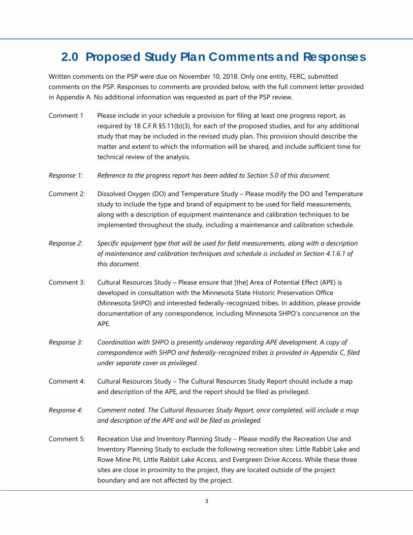
2.0 Proposed Study Plan Comments and Responses
Written comments on the PSP were due on November 10, 2018. Only one entity, FERC, submitted
comments on the PSP. Responses to comments are provided below, with the full comment letter provided
in Appendix A. No additional information was requested as part of the PSP review.
Comment 1 Please include in your schedule a provision for filing at least one progress report, as
required by 18 C.F.R §5.11(b)(3), for each of the proposed studies, and for any additional
study that may be included in the revised study plan. This provision should describe the
matter and extent to which the information will be shared, and include sufficient time for
technical review of the analysis.
Response 1: Reference to the progress report has been added to Section 5.0 of this document.
Comment 2: Dissolved Oxygen (DO) and Temperature Study – Please modify the DO and Temperature
study to include the type and brand of equipment to be used for field measurements,
along with a description of equipment maintenance and calibration techniques to be
implemented throughout the study, including a maintenance and calibration schedule.
Response 2: Specific equipment type that will be used for field measurements, along with a description
of maintenance and calibration techniques and schedule is included in Section 4.1.6.1 of
this document.
Comment 3: Cultural Resources Study – Please ensure that [the] Area of Potential Effect (APE) is
developed in consultation with the Minnesota State Historic Preservation Office
(Minnesota SHPO) and interested federally-recognized tribes. In addition, please provide
documentation of any correspondence, including Minnesota SHPO’s concurrence on the
APE.
Response 3: Coordination with SHPO is presently underway regarding APE development. A copy of
correspondence with SHPO and federally-recognized tribes is provided in Appendix C, filed
under separate cover as privileged.
Comment 4: Cultural Resources Study – The Cultural Resources Study Report should include a map
and description of the APE, and the report should be filed as privileged.
Response 4: Comment noted. The Cultural Resources Study Report, once completed, will include a map
and description of the APE and will be filed as privileged.
Comment 5: Recreation Use and Inventory Planning Study – Please modify the Recreation Use and
Inventory Planning Study to exclude the following recreation sites: Little Rabbit Lake and
Rowe Mine Pit, Little Rabbit Lake Access, and Evergreen Drive Access. While these three
sites are close in proximity to the project, they are located outside of the project
boundary and are not affected by the project.

4
Response 5: The Little Rabbit Lake and Rowe Mine Pit, Little Rabbit Lake Access, and Evergreen Drive
Access recreation sites have been removed from the Recreation Use and Inventory Planning
Study.
Comment 6: Botanical Resources Study – The PAD did not provide site-specific data on botanical
resources occurring at the project, and the proposed study plan does not indicate that
this information would be collected. Consequently, it is not possible to analyze the range
of effects to botanical and wildlife resources at the project. If you have existing data,
study or survey results, or information that would satisfy the requirements above, please
state this in your revised study plan and file this information in conjunction with the
revised study plan. If you cannot provide the information, the study plan should be
modified to provide for the botanical resources study, as outlined by staff in our
Comments on Preliminary Study Plans, Requests for Studies, and Additional Information,
and pursuant to the Commission’s regulations
Response 6: Additional information regarding botanical resources is provided in Appendix D of this RSP.
This information includes an evaluation of vegetation species based on available site
information, including species present; age class, species composition and relative density of
forested understory; presence of snags or old-growth hardwoods with sloughing bark; and
presence of invasive species.

5
3.0 Study Plan Proposals
3.1 Dissolved Oxygen and Temperature Study
FERC has requested a baseline dissolved oxygen (DO) and temperature study to evaluate the DO
concentration of water entering the Project intakes within the reservoir, then discharged immediately
downstream of the dam into the Mississippi River during summer conditions.
3.1.1 Goals and Objectives
The goal of this study is to determine if DO and temperature at the Project meet state water quality
standards. The objectives of this study are to (a) identify the DO concentration and temperature of water
entering the Project intakes, (b) describe any temporal variations of DO concentration and temperature,
(c) identify the DO and temperature profile within the Project reservoir in the vicinity of the intakes, and
(d) describe the changes of DO concentrations and temperature in the river downstream of the Project.
3.1.2 Known Resource Management Goals
The state of Minnesota has established water quality standards (Minnesota Rules, Chapter 7050) to
protect water resources for uses such as fishing, swimming, and other recreation and to sustain aquatic
life. These standards are a measure to identify polluted waters or healthy waters in need or protection and
guide the limits on what regulated facilities can discharge to surface water. These rules are administered
by the Minnesota Pollution Control Agency (MPCA). The MPCA is continually working to revise, develop,
and otherwise improve Minnesota’s water quality standards.
3.1.3 Public Interest Considerations
FERC must give equal consideration to all uses of the waterway on which a project is located and what
conditions should be placed on any license that may be issued. In making its license decision, FERC must
equally consider the environment, recreation, fish and wildlife, and other non-developmental values of the
Project, as well as power and other developmental values.
Water quality at the Project supports an aquatic ecosystem that provides public opportunities, including
sport fisheries. FERC considers the effects of Project operation on water quality relevant to its public
interest determination.
3.1.4 Background and Existing Information
The MPCA has a water quality monitoring station approximately 1,700 feet upstream of the Project, and
the U.S. Geological Survey (USGS) operates water quality monitoring stations downstream of the Project.
However, none of these stations have recorded measurements for DO and temperature.
In the absence of data in close proximately to the Project, raw monitoring data from all USGS and MPCA
water quality monitoring stations within a 1-mile radius were evaluated for relevance to this study,
resulting in the consideration of five additional monitoring stations. However, DO and temperature data

6
from these monitoring stations were either outdated (most dating to 2007 or prior) or nearly a mile away
from the Project.
3.1.5 Project Nexus
Typically, lower DO concentrations are most likely to exist during summer months when water
temperatures are increased. Collecting water temperature and DO data immediately upstream and
downstream of the Project during the summer months helps determine if Project operation is negatively
affecting water quality at the Project. Therefore, understanding current DO and temperature conditions
would inform the need for and development of potential license conditions to protect aquatic resources
at the Project.
3.1.6 Proposed Study Methodology
The proposed methodology for the Dissolved Oxygen and Temperature Study is described in the
following sections.
3.1.6.1 Data Collection
To sample the upstream portion of the Project, DO and temperature measurements will be taken in the
reservoir within an approximately 33-foot (10-meter) radius of the Project intake or at the closest safe
distance upstream from the Project intake. Turbines shall be operating at the time of the measurement.
DO and temperature measurements will begin approximately 3 feet (1 meter) below the surface of the
reservoir, with subsequent measurements taken at 3-foot (1-meter) intervals. Measurements shall
terminate within 3 feet (1 meter) of each intake structure. Field notes shall indicate the intake structure
where measurements were taken. To the extent feasible, based on turbine operations, an attempt will be
made to take measurements at consistent locations.
Downstream of the Project, DO concentration and temperature will be monitored and recorded at three
sites in the Mississippi River, located as follows: Site 1 – within approximately 150 feet downstream of the
Project, Site 2 – approximately 300 feet downstream of the Project, and Site 3 – approximately 450 feet
downstream of the Project. Samples will again be collected at 3-foot (1 meter) intervals beginning 3 feet
(1 meter) below the water surface. The habitat type of each sampling location (i.e., pool, run, riffle, etc.)
will be identified and recorded, along with GPS coordinates for each sampling location.
Upstream and downstream sampling will both take place weekly from June 1 through September 30. The
reservoir surface elevation will be recorded during each sampling event, and discharge in cubic feet per
second (cfs) from USGS stream gauge #05242300 (located at the Project) will be recorded.
Equipment to be used to take DO and temperature measurements is a YSI Optical DO Model EcoSense
ODO200/ODO200M or equivalent YSI meter equipped with an optical DO probe. The advantage of using
an optical DO meter is that it does not require a “warm-up” time, requires less frequent maintenance, and
the calibration can hold for several months.
The meter will require the following maintenance. The sensing element will be replaced annually in
accordance with detailed instructions provided in the YSI user manual. Calibration will be performed at

7
the beginning of the monitoring season, prior to the first sampling event. Prior to each weekly use, a
calibration check will be performed to determine whether the calibration has drifted, thus requiring
recalibration. The calibration check will be conducted as follows:
Place the DO sensor in the provided calibration environment (the sponge in the calibration
environment should be moistened).
Compare the % saturation reading of the instrument against the % saturation expected at the
prevailing atmospheric pressure conditions (available from the National Weather Service if
needed).
If absolute percent difference between the DO meter reading and the expected reading according
to the YSI manual is greater than 2%, the meter will be recalibrated.
If needed, recalibration will be conducted in accordance with the YSI user manual.
3.1.6.2 Reporting
Upon conclusion of DO and temperature-monitoring activities, a report will be compiled that includes
analytical summaries and graphical representations of the data, including average DO concentration and
average temperature with associated measures of confidence. The report will include a histogram of
depth, DO, and temperature within the reservoir and a graphical representation of any changes of these
components over the monitoring period. The report will also include a histogram of river distance, DO,
and temperature content with a similar graphical representation of any changes of these components
over the monitoring period. All data points used to develop the report (including latitude/longitude
coordinates, date, and time of data collection) will be included as a report appendix.
3.1.7 Cost and Level of Effort
The estimated cost of conducting this study is approximately $20,000 based on the level of effort
described above. The Dissolved Oxygen and Temperature Study is expected to take place during one
study season in 2019.
3.2 Cultural Resources Study
A cultural resources study is proposed to determine the potential effects of existing operations and the
Project on archaeological and historic resources within an area of potential effect (APE) that is currently
being determined in coordination with the State Historic Preservation Office (SHPO). The study will focus
on resources that are included or eligible for listing on the National Register of Historic Places (NRHP) and
may be affected over the life of the Project.
3.2.1 Goals and Objectives
The goal of this study is to determine the potential effects of Project operations on archaeological and
historic resources within the APE that are included or eligible for listing on the NRHP. This study will be
developed in coordination with FERC, SHPO, and any federally recognized tribes with expressed interest in
the Project.

8
3.2.2 Known Resource Management Goals
FERC’s issuance of a new license for the continued operation of the Project is subject to approval under
Section 106 of the National Historic Preservation Act (NHPA), which requires federal agencies to consider
the effects of a proposed undertaking (i.e., relicensing) on resources listed or eligible for listing on the
NRHP.
In accordance with FERC regulation (18 CFR §5.5(e)), FERC has authorized BPU as the non-federal
representative to conduct informal Section 106 consultation with SHPO.
Previous studies have identified 33 archaeological sites within the Project's APE that were determined or
are believed to have significant archaeological research potential. Resource management goals for these
sites include the following:
1. The development of a Cultural Resources Management Plan (CRMP) in coordination with FERC
and SHPO that will establish a formal schedule for monitoring the 33 archaeological sites within
the Project's APE
2. The development of a plan to install/reinstall monitoring control points in a manner that is less
subject to disturbance by natural environmental factors
3. The development of a plan to conduct Phase II investigations at four archaeological sites that
appear to be at risk of disturbance through erosion and loss of shoreline
3.2.3 Public Interest Considerations
FERC must consider the impacts that Projects may have on Historic Properties under Section 106 of the
NHPA. The Section 106 process requires consultation with the SHPO, federally recognized tribes with
expressed interest in the Project, and other stakeholders. To date, no tribes have indicated interest in the
Project.
The locations of archaeological sites is considered protected information; therefore. Locations of
archaeological sites may not be distributed to the public.
3.2.4 Background and Existing Information
Between 1989-1990, cultural resource investigations were performed and documented in the Cultural
Resource Inventory and Evaluations around the Brainerd Reservoir, Crow Wing County, Minnesota
(FERC#2533) (reference (2)) Report. This report informed the 1992 Programmatic Agreement (PA) between
FERC, the Advisory Council on Historic Preservation (the Council), and SHPO for Management of Historic
Properties Affected by the Project.
In 1995, a CRMP (reference (3)) was developed based on the provisions of the PA. Licensees of the Project
have followed the 1995 CRMP for management of cultural resources within the 1995 established Project
APE.

9
The archaeological sites in the 1995 established Project’s APE were most recently inspected in 2017 and
recommendations made for further treatment were documented in the Cultural Resources Monitoring
Report (reference (4)) following the requirements of the 1995 CRMP. A Cultural Resources Treatment Plan
and Schedule (reference (5)) was developed in 2018 to address recommendations in the Cultural Resources
Monitoring Report (reference (4)).
Management of cultural resources as required by the 1992 PA will continue for the duration of the
existing license. The next Cultural Resources Monitoring Report is scheduled to be filed by March 2, 2020.
3.2.5 Project Nexus
The proposed cultural resources study will provide current information on historic and archaeological
resources potentially eligible for listing within the Project’s APE. The study will identify potential adverse
effects to historic and cultural resources resulting from continued Project operations and will provide a
basis for SHPO concurrence of potential effects, as well as help facilitate the Section 106 consultation
process.
3.2.6 Proposed Study Methodology
As a first step in development of the cultural resources study for the relicensing effort, the project’s APE
requires review. BPU has assessed the APE identified in the 1995 CRMP and compared this existing APE’s
extents to present and historic (pre-Project) conditions. Key findings from this comparison include (1) on
the upstream end of the Project, the APE boundary extends to the point where the river contracts back to
the pre-Project width and (2) on the downstream end of the Project, the Project did not appear to affect
the width of the river. Based on the findings of this comparison, BPU proposes to retain the existing APE
for the cultural resources study included in the PSP, this RSP, and for relicensing. Coordination regarding
the methodology for APE assessment and APE determination is currently underway with SHPO and
interested federally-recognized tribes, and a request for APE concurrence has been submitted to these
parties. SHPO and tribal correspondence is included in Appendix C (filed under a separate cover as
privileged).
The methods used to conduct the Phase II investigations, as recommended for four archaeological sites
within the APE, will consist of standard methodology and will be conducted in accordance with guidelines
put forth by the SHPO. Phase II testing will consist of the excavation of 1- by 1-meter or 1- by 2-meter
test units. The test units will be placed adjacent to the areas of active erosion to assess the nature and
quality of the archaeological deposits and to determine if mitigation strategies are necessary.
The Cultural Resources Study Report, once completed, will compile findings and recommendations,
relevant maps, and a description of the APE. This report will be filed with FERC as privileged and
submitted to SHPO.
3.2.7 Cost and Level of Effort
The estimated cost of conducting this study is approximately $50,000 based on the level of effort
described above. The Phase II investigations and a portion of the monitoring control point installations

10
are expected to take place during one season in 2019. Monitoring will take place in subsequent years as
dictated by the CRMP.
3.3 Desktop Fish Entrainment and Impingement Study
At the request of FERC, a desktop fish entrainment and impingement study is proposed to evaluate fish
entrainment (i.e., involuntary passage through intakes and turbines) and fish impingement (i.e.,
involuntary entrapment against Project features such as screens, trashracks, etc.). As described further
below, this desktop assessment approach relies on results of published turbine passage survival studies
and site-specific turbine specifications to estimate entrainment rates and fish passage survival.
Impingement will be evaluated qualitatively using publicly available information about fish morphology,
trashrack spacing, and calculated approach velocities at intake areas. Estimates derived from this desktop
study are expected to be suitable for determining general potential for and levels of entrainment and
impingement that may occur as a result of the Project; the findings should not be considered absolute
quantitative results.
3.3.1 Goals and Objectives
The goal of this study is to evaluate the potential for fish entrainment and impingement at the Project and
its potential effects on the health of the Upper Mississippi River fishery. The objectives of this study are to:
Describe the physical characteristics of the intake structures, including the location, dimensions,
and the velocity distribution in front of each structure.
Analyze fish species for factors that influence their vulnerability to impingement, entrainment, and
turbine survival.
Assess the potential for fish species impingement at the Project.
Estimate entrainment rates and turbine-passage survival rates for fish species at the Project.
Describe the likely effects of Project-induced entrainment or impingement on fish resources,
based on the physical characteristics of the Project.
3.3.2 Known Resource Management Goals
In Minnesota, fisheries and conservation programs are principally managed by the Minnesota Department
of Natural Resources (MNDNR) at the state level and by the U.S. Fish and Wildlife Service (USFWS) at the
federal level. MNDNR aims to sustain healthy waterways, conserve aquatic species and habitat, and
provide the public access to outdoor recreational opportunities. To enhance fisheries in Minnesota, the
MNDNR practices ecosystem-based fisheries management to ensure long-term health of fisheries in rivers
and lakes, including the Mississippi River. As part of the MNDNR Ecological and Water Resources
Division’s 2018–2028 Strategic Plan (Reference (6)), the agency emphasized a focus on managing water
resources sustainably and preserving biological diversity. The goals of the agency include managing water
resources sustainably and improving or maintaining water quality throughout the state. To protect local
species, the agency aims to prevent the spread of invasive species and to minimize the impact of these

11
invasive species if they do spread. Finally, the agency will focus in the coming years on protecting
ecosystems from the impacts of climate change.
The USFWS also plays a role in managing fisheries on the Upper Mississippi River. According to the
agency’s 2016–2020 Strategic Plan (Reference (7)), it aims to conserve aquatic species through
conservation, restoration, and enhancement of habitat. This includes managing aquatic invasive species,
many of which threaten the Mississippi River. Additionally, the agency will promote and enhance
recreational fishing and other public uses of aquatic resources and educate the public about conservation.
3.3.3 Public Interest Considerations
Sections 4(e) and 10(a) of the Federal Power Act require that FERC give equal consideration to all uses of
the waterway on which a project is located. In making its license decision, FERC must equally consider the
environmental, recreational, fish and wildlife, and other non-developmental values of the Project, as well
as power and developmental values.
Fish populations in the Project boundary support a sport fishery. As such, the effects that operating the
Project may have on fisheries resources are relevant to FERC’s public interest determination.
3.3.4 Background and Existing Information
The powerhouse is a 256-foot long structure. Flumes are numbered one through 10 with number one
being closest to the river and number 10 closest to the left embankment. Flumes one through five are
currently used for power generation. The Amjet turbine will be installed in flume six. The flume intakes are
approximately 15 feet wide and the distance from normal water elevation to the concrete sill at the
trashrack is approximately 16 feet. Trashracks are located in front of the intakes to minimize fish
entrainment. Trash racks consist of 3” by ¼” bars spaced at 2 inches on center.
3.3.5 Project Nexus
The operations of the Project may result in the mortality of entrained or impinged fish during normal
operations. In general, hydropower dams may affect fish species that are more subject to travel through
the riverine system than fish species that may inhabit only certain portions of the riverine system (i.e.,
pools or the impoundment area) for their entire life cycles.
3.3.6 Proposed Study Methodology
The methodology for this analysis will follow standard methods and data sources previously accepted by
FERC or standard methods used by fisheries management professionals for desktop evaluation of
impingement, entrainment, and turbine mortality (References (8), (9), (10), and (11) ). Fish that are small
enough to pass through the Project’s trash racks will be considered susceptible to entrainment. Individuals
large enough to be physically excluded due to size (length, width/body depth) will be considered as
potentially susceptible to impingement. Fish species found in the Project reservoir may not be equally
susceptible to impingement or entrainment because of individual species habitat use, behaviors, or
swimming abilities.

12
Fish species and abundance information available from the MNDNR and MPCA will be used to
characterize the fisheries community composition upstream of the Project. Fish species will be grouped
into family groups and size classes for evaluation. For species/family groups where no comparable or
applicable data can be found, the survival rate reported for a similar group/size class will be substituted.
Fish species/groups for evaluation will be developed in conjunction with the MNDNR. Preliminary review
of fisheries data indicates evaluation of walleye, smallmouth bass, largemouth bass, channel catfish, yellow
perch, northern pike, bigmouth buffalo, white sucker, shorthead redhorse, and silver redhorse will be
considered as potential target species/groups.
Fish entrainment and mortality data from other similar hydroelectric projects (head, turbine type, flow
capacity, etc.) will be selected from the databases available from the Electric Power Research Institute
(Reference (12)) and FERC (Reference (8)) to develop a BPU project estimate using the Project-specific fish
species/group assemblages. The evaluation will be sequenced with the following inputs:
1. Develop a matrix of entrainment/impingement/mortality studies that can be applied to the BPU
Project.
2. Calculate and estimate fish entrainment rates at the Project site based on available Project
operation information. Maximum approach velocity at each turbine will be estimated based on
the size of the intake area and the maximum hydraulic capacity at each turbine. Entrainment will
be defined as the number of fish/volume of water entrained.
3. Utilize reservoir-specific species compositions in conjunction with applicable prior studies to
characterize the composition of the fish community susceptible to impingement or entrainment.
4. Apply physical, biological, or reservoir factor filters that may impact susceptibility to impingement
or entrainment at the Project.
5. Estimate the potential for turbine mortality of entrained fish based on turbine mortality estimates
from project studies at similar sites. Utilize blade-strike mortality models developed by Franke et
al. (Reference (13)) if applicable studies are not available.
6. Estimate impingement mortality for fish eliminated from entrainment estimates.
7. Report estimates of entrainment, mortality, and impingement on a monthly fish group/size per
hour of Project operation and fish per volume of water passed through the Project. Estimated
monthly entrainment and impingement rates will be reported based on the relative abundance of
species according to existing fisheries data from the MNDNR.
3.3.7 Cost and Level of Effort
The estimated cost of conducting this study is approximately $30,000 based on the level of effort
described above. The Desktop Fish Entrainment and Impingement Study is expected to take place over a
3-month period in 2019.

13
3.4 Recreation Use and Inventory Planning Study
A recreation and inventory planning study is proposed to assess the condition of recreation sites/facilities
within the Project boundary and site use. This type of study was also requested by MNDNR, and FERC
provided comments for consideration in study development.
3.4.1 Goals and Objectives
The goals of this study are to gather information on existing recreation sites/facilities, evaluate existing
recreational use and capacity, and estimate future recreation demands within the Project boundary. The
objectives of this study are to:
Identify the condition of all informal and formal recreation sites and facilities wholly or partially
within the Project boundary.
Determine current and projected capacity at each recreation site/facility.
Identify who owns, operates, and maintains each recreation site/facility.
Conduct visitor surveys during the recreation season to determine the adequacy of Project
recreation facilities and whether modifications or upgrades are needed to meet current or future
recreation needs.
3.4.2 Known Resource Management Goals
As noted above, the MNDNR aims to sustain healthy waterways, conserve aquatic species and habitat,
and provide the public with access to outdoor recreational opportunities. The MNDNR’s water recreation
goal is to provide and maintain free, safe, and convenient access to public waters for recreation while
protecting and enhancing natural resources through facility design, program management, and public
education. In its study request, MNDNR expressed interest in identifying how river recreation is affected
by the dam and reservoir.
3.4.3 Public Interest Considerations
Section 4(e) and 10(a) of the Federal Power Act require that FERC give equal consideration to all uses of
the waterway on which a project is located. In making its license decision, FERC must equally consider the
environmental, recreational, fish and wildlife, and other non-developmental values of the Project, as well
as power and developmental values.
The Project allows for and supports several recreation opportunities, including boating, hiking, fishing,
watersports, and passive recreation activities. As such, the Project’s effects on recreational resources is
relevant to FERC’s public interest determination.
3.4.4 Background and Existing Information
The Project supports a variety of recreation opportunities. BPU owns and maintains a canoe portage
within the Project boundary, located on the west side of the impoundment, immediately upstream from

14
the dam. This facility allows canoeists a means to safely pass from the upstream side of the dam to the
downstream side.
The following recreation sites are located within the Project boundary, but are operated by different
entities:
Lum Park – This facility is owned and operated by the City of Brainerd, with a motorized boat
launch providing access to Rice Lake and the Mississippi River. Additional recreational amenities
at Lum Park include a public swimming beach, restroom and shower facilities, a fishing pier,
pavilion, playground, sand volleyball courts, and a disc golf course.
French Rapids access – Crow Wing County maintains a public motorized boat launch, picnic area,
and shoreline fishing area in this location.
Green’s Point access – This location features a carry-in boat launch point, as well as a shoreline
fishing area and is maintained by the MNDNR.
3.4.5 Project Nexus
BPU provides recreational opportunities within the Project boundary in accordance with the conditions of
its existing license. It also has a responsibility for ongoing maintenance of its recreation facilities
throughout the license term. FERC requires licensed projects to provide reasonable public recreation
opportunities consistent with the safe and effective operation of the Project. FERC also has ongoing
responsibility to ensure that those recreation facilities meet recreational demand over the term of the new
license.
MNDNR requested recreational-use surveys be completed for flowing and impounded stretches of the
river but did not provide spatial boundaries in their request. As such, the Recreation Use and Inventory
Planning Study extents will be primarily limited to the four facilities located within the Project boundary
(BPU canoe portage, Lum Park, French Rapids access, and Green’s Point access).
3.4.6 Proposed Study Methodology
The proposed methodology for the Recreation Use and Inventory Planning Study is described in the
following sections.
3.4.6.1 Facility Inventory and Condition Assessment
BPU will conduct a site inventory and condition assessment at each of the following recreation sites:
Canoe portage
Lum Park
French Rapids access
Green’s Point access

15
The facility inventory and condition assessment will include a brief description of each site and location of
the facilities in relation to the Project boundary:
Identification of whether or not the facility is located within the Project boundary
Ownership and party responsible for operation and maintenance of each facility
Hours and seasons of operation
Type, number, and condition of amenities provided, including parking and signage
General observations of site use and accessibility
Identification of areas that show signs of erosion or other forms of instability
Photographs will accompany the facility inventory and condition assessment, and coordination will take
place with each facility operator to discuss projected capacity at each recreation site/facility.
3.4.6.2 Recreation Use Survey
BPU will conduct a recreation use survey at each of the four sites included in the facility inventory and
condition assessment effort. A draft of the recreational use survey questionnaire is provided in Appendix
E.
All sampling days will be randomly selected. Survey routes will be completed on a rotating basis and at
different times of day to account for time-of-day use patterns. Each count will last for 2 hours per site, per
day and will be conducted on 4 days per month, including two randomly selected weekdays and two
randomly selected weekend days. If a month contains a three-day holiday weekend (i.e., Memorial Day,
Independence Day, Labor Day), one day per holiday weekend will be included in addition to the standard
survey days. The recreation use surveys will be completed during the recreation season to capture
recreational use occurring while the facilities are open to the public. The recreation season for this Project
is defined as the opening weekend of fishing season (mid-May) to the opening weekend of waterfowl
hunting season (late September).
The recreation use survey will be administered to facility users to gain opinions with regard to existing
recreation facilities and opportunities. This survey will record the number of people in a party, their
primary reason for visiting the site (i.e., type of recreation), their perception of level of site use, and their
opinions with regard to the amount and types of recreation opportunities offered within the Project
boundary.
3.4.6.3 Spot Counts
Spot counts will be conducted in conjunction with the recreation use survey. Spot counts are brief in
duration to provide a snapshot of use at each recreation site. Spot counts will last approximately
5 minutes and will record the number of vehicles parked at a site and the number of users observed. This
information will be used in estimating site use.

16
3.4.6.4 Reporting
BPU will prepare a report that includes a discussion of study area, study methodology, and analysis of the
study findings. The report will document the number of days spent at the monitored sites, average
number of persons per party, and will include a determination of the percent of each facility’s capacity
currently utilized. The report will also provide documentation of the facility inventory. Potential future
recreation demand and needs over the term of the license will be assessed based on the results of the
facility inventory and condition assessment, existing recreation use, and estimated population projections
and the demand for future recreational resources.
3.4.7 Cost and Level of Effort
The estimated cost of conducting this study is approximately $20,000 based on the level of effort
described above. The Recreation Use and Inventory Planning Study is expected to take place during one
study season in 2019.

17
4.0 Anticipated Study Schedule
FERC’s Study Plan Determination is anticipated by January 9, 2019, allowing BPU to undertake most of the
proposed studies in 2019, as noted in Table 4-1. Additional detail on the overall study process schedule
can be found in Appendix A of the PAD. In accordance with 18 CFR §5.11(b)(3), progress reports will be
completed following field data collection, prior to development of the associated reports. Due to the
concurrent period for all four studies proposed, it is anticipated that a single progress report will be
prepared to address all studies. The progress report will include summaries of field data collection efforts
and attachments of data collected, as appropriate.
Based on FERC’s ILP regulations, Initial Study Report (ISR) is due 1 year following FERC’s Study Plan
Determination (January 9, 2020). In order to obtain agency feedback prior to the 2020 field season, BPU
anticipates that the ISR meeting will occur in January 2020.
Table 4-1 Anticipated Study Schedule
Study
Anticipated Start
Date Anticipated Completion Date
Dissolved Oxygen and Temperature Study June 1, 2019 September 30, 2019
Cultural Resources Study June 1, 2019 Fall of 2019 for Phase II investigations
Desktop Fish Entrainment and Impingement Study May 2019 July 2019
Recreation Use and Inventory Planning Study Mid-May 2019 Late-September 2019

18
5.0 References
1. Federal Energy Regulatory Commission (FERC). Division of Hydropower Administration & Compliance,
Compliance Handbook. Washington : Department of Energy, 2015.
2. Harrison, Christina, Burnett County Historical Society. Report on Cultural Resource Reconnaissance
Survey Around the Brainerd Reservoir, Crow Wing County, Minnesota. s.l. : prepared for Potlatch
Corporation Northwest Paper Division, 1991.
3. Mead & Hunt, Inc. Cultural Resources Management Plan for the Management of Historic Properties
Affected by the Brainerd Hydroelectric Project FERC Project No. 2533. June 1995. Brainerd, Minnesota :
s.n., June 1995.
4. Barr Engineering Co. Cultural Resources Monitoring Report, Brainerd Hydroelectric Project FERC License
No. 02533. Brainerd, Minnesota : Brainerd Public Utilites, March 14, 2018.
5. —. Cultural Resources Treatment Plan and Schedule, Brainerd Hydroelectric Project FERC License No.
2533. Brainerd, Minnesota : Brainerd Public Utilites, August 30, 2018.
6. Minnesota Department of Natural Resources. Ecological and Water Resources Division Strategic Plan
2018-2028. Minnesota Department of Natural Resources. [Online] 2018.
https://files.dnr.state.mn.us/eco/ewr-strategicplan.pdf.
7. U.S. Fish and Wildlife Service. Strategic Plan for the U.S. Fish and Wildlife Service Fish and Aquatic
Conservation Program: FY2016-2020. U.S. Fish and Wildlife Service. [Online] 2016.
https://www.fws.gov/fisheries/pdf_files/FAC_StrategyPlan_2016-2020.pdf.
8. Federal Energy Regulatory Commission (FERC). Preliminary Assessment of Fish Entrainment at
Hydropower Projects, a Report on Studies and Protective Measures. Washington, D.C. : FERC Office of
Hydropower Licensing, 1994 and 1995. Vol. 1 and 2.
9. Alden Research Laboratory, Inc. Guidelines for Hydro Turbine Fish Entrainment and Survival Studies.
EPRI Report No. TR-107299 Holden, MA : Electric Power Research Institute, July 1997.
10. Cada, G.F., Coutant, C.C. and Whitney, R.R. Development of Biological Criteria for the Design of
Advanced Hydropower Turbines. Idaho Falls, ID : U.S. Department of Energy, 1997.
11. Bell, M.C. Revised Compendium on the Success of Passage of Small Fish through Turbines. Portland,
OR : U.S. Army Corps of Engineers, North Pacific Division, 1991.
12. Alden Research Laboratory, Inc. Turbine Entrainment and Survival Database--Field Tests. EPRI Report
No. TR-108630 Holden, MA : Electric Power Research Institute (EPRI), October 1997.

19
13. Franke, G.F., et al. Development of Environmentally Advanced Hydropower Turbine System Concepts.
s.l. : Department of Energy, 1997. DEAC07-96ID13382.
14. Hess, Jeffrey H. of Hess Roise and Company. Determination of National Register Eligibility for the
Hydroelectric Plant and Associated Paper Mill of the Potlatch Corporation in Brainerd, Minnesota. s.l. :
prepared for Potlatch Corporation Northwest Paper Division, January 1991.
15. Minnesota Department of Agriculture. Mapping Minnesota's Noxious Weeds. Minnesota
Department of Agriculture. [Online] [Cited: July 2, 2018.] https://app.gisdata.mn.gov/mda-
noxiousweeds/index.htm?4390.
16. US Army Corps of Engineers. Engineering and Design - Hydropower. Washington DC : Department of
the Army, 1985. EM 110-2-1701.
17. Mead & Hunt, Inc. Initial Consultation Package, Brainerd Hydroelectric Project, F.E.R.C Project No.
2533. Brainerd : Potlatch Corporation, 1988.
18. Barr Engineering Co. Cultural Resources Monitoring Report: Brainerd Hydroelectric Project, FERC
License No. 2533, Prepared for Brainerd Public Utilities. 2018.

Appendix A
Proposed Study Plan Comments

FEDERAL ENERGY REGULATORY COMMISSIONWASHINGTON, D. C. 20426
November 6, 2018
OFFICE OF ENERGY PROJECTS
Project No. 2533-017 – MinnesotaBrainerd Hydroelectric ProjectBrainerd Public Utility
Mr. Scott MagnusonSuperintendentBrainerd Public Utility8027 Highland Scenic RoadPO Box 373Brainerd, MN 56401
Reference: Staff Comments on the Proposed Study Plan for the BrainerdHydroelectric Project
Dear Mr. Magnuson:
We have reviewed Brainerd Public Utility’s (Brainerd) proposed study plan for the Brainerd Hydroelectric Project filed on August 10, 2018. We provided verbal comments on the proposed study plan during the September 11, 2018 study plan meeting.1 Weexpect Brainerd to take those comments into consideration during the development of the revised study plan, which is due to be filed on December 10, 2018. In addition, we are providing written comments pursuant to section 5.12 of the Commission’s regulations onthe Dissolved Oxygen and Temperature Study, Cultural Resources Study, Recreation Use and Inventory Planning Study, and Botanical Resources Study. Comments are provided in the attached Schedule A.
The 90-day comment period for the proposed study plan is intended to be used to resolve stakeholder concerns with study methods. We encourage Brainerd to follow up with agencies and stakeholders, and hold additional meetings if needed.
Please include in your schedule a provision for filing at least one progress report, as required by 18 C.F.R. §5.11(b)(3), for each of the proposed studies, and for any additional study that may be included in the revised study plan. This provision should
1 A summary of the study plan meeting was filed by Brainerd on
October 10, 2018.

Project No. 2533-017 2
describe the manner and extent to which information will be shared, and include sufficient time for technical review of the analysis.
If you have any questions, please contact Patrick Ely at [email protected] or (202) 502-8570.
Sincerely,
Janet Hutzel, ChiefMidwest BranchDivision of Hydropower Licensing
Enclosure: Schedule A

Schedule AProject No. 2533-017
A-1
Comments on the Proposed Study Plan
Dissolved Oxygen (DO) and Temperature Study
Please modify the DO and Temperature study to include the type and brand of equipment to be used for field measurements, along with a description of equipment maintenance and calibration techniques to be implemented throughout the study,including a maintenance and calibration schedule.
Cultural Resources Study
Please ensure that Area of Potential Effect (APE) is developed in consultation with the Minnesota State Historic Preservation Office (Minnesota SHPO) and interested federally-recognized tribes. In addition, please provide documentation of any correspondence, including Minnesota SHPO’s concurrence on the APE. The Cultural Resources Study report should include a map and description of the APE, and the report should be filed as privileged.
Recreation Use and Inventory Planning Study
Please modify the Recreation Use and Inventory Planning study to exclude the following recreation sites: Little Rabbit Lake and Rowe Mine Pit, Little Rabbit Lake Access, and Evergreen Drive Access. While these three sites are close in proximity to the project, they are located outside of the project boundary and are not affected by the project.
Botanical Resources Study
Section 5.6(d)(3)(v) of the Commission’s regulations requires a description of the wildlife and botanical resources, including invasive species, in the project vicinity. Components of this description must include: (A) upland habitat(s) in the project vicinityand a listing of plant and animal species that use the habitat(s); and (B) temporal or spatial distribution of species considered important because of their commercial, recreational, or cultural value.
The PAD did not provide site-specific data on botanical resources occurring at the project, and the proposed study plan does not indicate that this information would becollected. Consequently, it is not possible to analyze the range of effects to botanical and wildlife resources at the project. If you have existing data, study or survey results, or other information that would satisfy the requirements listed above, please state this in your revised study plan and file this information in conjunction with the revised study plan. If you cannot provide the information, the study plan should be modified to provide

Schedule AProject No. 2533-017
A-2
for the botanical resources study, as outlined by staff in our Comments on Preliminary Study Plans, Request for Studies, and Additional Information,2 and pursuant to the Commission’s regulations.
2 Issued June 27, 2018.

Appendix B
Preliminary Study Plan Meeting Minutes

Meeting Notes
Brainerd Dam – Proposed Study Plan MeetingSeptember 11, 201810:00 am – 11:00 am
Attendees: Shanna Braun (Barr), Adéle Braun (Barr), Scott Magnuson (BPU), Bonnie Finnerty (MPCA), Jay
Summers (FERC), Patrick Ely (FERC), Tyrone Williams (FERC), Shana Wiseman (FERC), Laura Washington
(FERC), Janet Hutzel (FERC), Jen Tyler (EPA Region 5 Chicago), Sarah Beimers (Mn SHPO), Bill Latady (Bois
Forte Band of Chippewa Indians).
Agenda Topic
Introductions Proposed Study Plan (PSP) meeting goals and objectives Proposed studies included in the PSP Studies not proposed in the PSP New information in the FERC Scoping Document 2 Open Discussion
Proposed studies included in the PSP1. Dissolved Oxygen and Temperature Study
The study in the PSP was described A request was made to include the type and brand of equipment planned for use during the
study along with the calibration method be included in the revised study plan. A question was asked if the data will become publically available after it is collected. An answer
to this question is not known at this time but will be considered.
2. Cultural Resources Study The study in the PSP was described It was noted that the APE should include areas inside and outside of the project areas.
Consultation on the APE should start now before the revised study plan is developed. Consultation should include FERC, SHPO, and tribes.
It was noted that it is critical to get a good definition the undertaking (i.e. what is the federal project, in this case, license renewal). A determination needs to be done to assess the validity of previous cultural studies that have been performed, which pre-dates changes to amendments to Section 106 in 1992. Section 106 discussion needs to start now.
The importance of including tribes in this process was noted as tribes were likely not included during the previous relicensing evaluation.
It was noted that it is better to include more tribes than less; however, no specific additional tribes were identified for addition to the distribution list. If additional tribes should be added to the consultation list, a contact individual should be provided to Laura Washington ([email protected]) and Adéle Braun ([email protected]).
3. Desktop Fish Entrainment and Impingement Study The study in the PSP was described

Page 2
2
It was noted that recent MNDNR fish sampling data from above the dam could be used tonarrow down the species evaluated in the study.
It was noted that in their comments on the PAD, the MNDNR questioned looking at a one-inchtrash rack. As part of this study, a comparison can be done considering the existing site and thepotential for a one-inch trash rack. Examples can be provided on previous studies. This wouldhelp with later analysis. If this study does occur, the cost of installing a one-inch trash rack wouldbe needed.
4. Recreation Use and Inventory Planning Study The study in the PSP was described It was noted that it would be helpful to distribute the survey instrument/form to the distribution
list while the PSP is under review so that this form could be evaluated in conjunction with thestudy.
Studies not proposed in the PSP1. Botanical Resources Study
The requested study and reasons for not proposing the study in the PSP was described. It was noted that the PAD did not present sufficient information to understand the botanical
resources in the area and there may be incorrect information noted in the PSP. The purpose forrequesting this study was to determine how operations will impact resources. For that reason,land cover maps were requested along with identification and quantification of the botanicalresources to allow the reader of the EA to develop a mental picture of the resources in the projectboundary. It was noted that the more information the better so that if a threatened orendangered species is becomes listed during the relicensing process, a determination of effect tothis species can quickly be made pertaining based on habitat characteristics of the area.
2. Impoundment, Bathymetric Study, and Sediment Accumulation and Containment Study The requested study and reasons for not proposing the study in the PSP was described. There was
no additional discussion on this item.
Additional Discussion1. Climate Resiliency
There was a question if climate resiliency of the project’s infrastructure will be addressed in the EAto determine if any measures or plans are needed
It was noted that an analysis on climate resiliency of the project’s infrastructure will not beincluded in the EA, but a discussion was included in Scoping Document 2 (SD2) to that effect. Thereason climate resiliency of the project’s infrastructure is not considered is that a robust damsafety program is already developed for FERC dams which account for this.

Appendix C
APE Coordination
(Privileged and Confidential – filed under separate cover)

Appendix D
Botanical Resources Review

Barr Engineering Co. 4300 MarketPointe Drive, Suite 200, Minneapolis, MN 55435 952.832.2600 www.barr.com
Memorandum
To: File
From: Daniel Tix, PhD and Shanna Braun
Subject: Botanical Resources Review for Brainerd Public Utilities
Date: 11/30/2018
Project: BPU – FERC Relicensing, Revised Study Plan
Background
FERC requested a Botanical Resources Study in a letter dated June 27, 2018 to map and/or confirm vegetation types within the Project boundary, including age-class and composition of forested area; rare, threatened, or endangered plant species or potential habitats; and document presence, absence, and location of invasive plant species.
In its August 20, 2018 Proposed Study Plan (PSP), BPU did not adopt this study request for the following reasons:
• The Project is operated as a run-of-river project and maintains a target elevation of 1174.04 feet, with fluctuations limited to 0.1 foot. As such, adjacent lands experience little change in water elevation, posing minimal change to vegetation communities and habitat types.
• There are no federally listed threatened or endangered plant species found in Crow Wing County, where the Project is located. In addition, there are no designated critical habitats for any federally listed species in Crow Wing County.
• Based on review using the Minnesota Department of Natural Resources (MNDNR) Natural Heritage Inventory System (NHIS) database, there are no state-listed plant species in the vicinity of the Project boundary.
• The Minnesota Department of Agriculture’s Noxious Weed Mapper was reviewed to assess the presence of noxious weed infestations within the Project boundary. There are three mapped noxious weed occurrences in the Project area: two purple loosestrife occurrences observed in 2007/2008 and one common tansy occurrence observed in 2013. Mapped noxious weed occurrences are included in the attached Noxious Weed Records figure. This information was not included in the PAD.
• The only land BPU owns adjacent to the Project boundary is immediately surrounding the dam and auxiliary facilities. This land primarily comprises access roadways and facility structures. BPU actively mows and manages weeds on green spaces associated with these areas.
• BPU does not own or manage additional lands beyond the Project boundary limits and is not authorized to dictate vegetation management, including noxious weed control, of these lands.
To: File
From: Daniel Tix, PhD and Shanna Braun
Subject: Botanical Resources Review for Brainerd Public Utilities
Date: 11/30/2018
Page: 2
P:\Mpls\23 MN\18\23181016 BPU Due Diligence\WorkFiles\05-8_FERC Relicensing\608_Revised Study Plan\Appendices\Appendix D - Botanical Review\Components\Botanical Resources Memo.docx
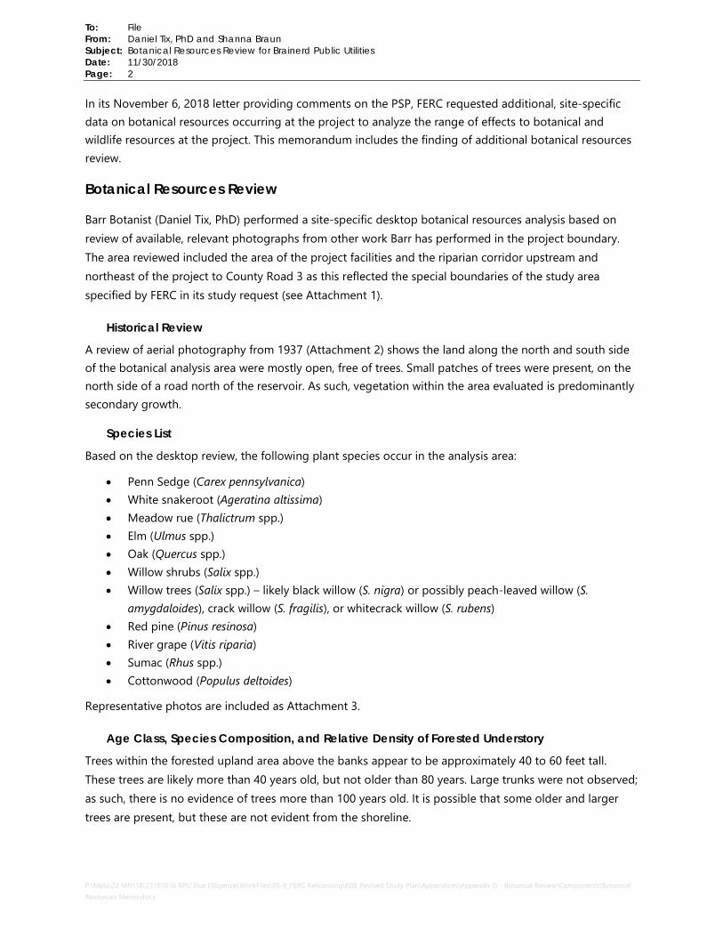
In its November 6, 2018 letter providing comments on the PSP, FERC requested additional, site-specific data on botanical resources occurring at the project to analyze the range of effects to botanical and wildlife resources at the project. This memorandum includes the finding of additional botanical resources review.
Botanical Resources Review
Barr Botanist (Daniel Tix, PhD) performed a site-specific desktop botanical resources analysis based on review of available, relevant photographs from other work Barr has performed in the project boundary. The area reviewed included the area of the project facilities and the riparian corridor upstream and northeast of the project to County Road 3 as this reflected the special boundaries of the study area specified by FERC in its study request (see Attachment 1).
Historical Review
A review of aerial photography from 1937 (Attachment 2) shows the land along the north and south side of the botanical analysis area were mostly open, free of trees. Small patches of trees were present, on the north side of a road north of the reservoir. As such, vegetation within the area evaluated is predominantly secondary growth.
Species List
Based on the desktop review, the following plant species occur in the analysis area:
• Penn Sedge (Carex pennsylvanica) • White snakeroot (Ageratina altissima) • Meadow rue (Thalictrum spp.) • Elm (Ulmus spp.) • Oak (Quercus spp.) • Willow shrubs (Salix spp.) • Willow trees (Salix spp.) – likely black willow (S. nigra) or possibly peach-leaved willow (S.
amygdaloides), crack willow (S. fragilis), or whitecrack willow (S. rubens) • Red pine (Pinus resinosa) • River grape (Vitis riparia) • Sumac (Rhus spp.) • Cottonwood (Populus deltoides)
Representative photos are included as Attachment 3.
Age Class, Species Composition, and Relative Density of Forested Understory
Trees within the forested upland area above the banks appear to be approximately 40 to 60 feet tall. These trees are likely more than 40 years old, but not older than 80 years. Large trunks were not observed; as such, there is no evidence of trees more than 100 years old. It is possible that some older and larger trees are present, but these are not evident from the shoreline.

To: File
From: Daniel Tix, PhD and Shanna Braun
Subject: Botanical Resources Review for Brainerd Public Utilities
Date: 11/30/2018
Page: 3
P:\Mpls\23 MN\18\23181016 BPU Due Diligence\WorkFiles\05-8_FERC Relicensing\608_Revised Study Plan\Appendices\Appendix D - Botanical Review\Components\Botanical Resources Memo.docx
Some red pines were observed that appear to be planted in rows. They appear to be 50 to 70 feet tall and are presumably 40 to 60 years old. They are mostly on the northern shore in discontinuous patches; there is not a single plantation.
An island within the analysis area has several smaller trees, likely willow, green ash, and elm that have relatively sparse canopy cover. Trees are likely 30 to 50 years old. Dense shrubs are also present with river grape and possibly other vines.
Within the evaluation area, the forested understory appears to have moderate coverage of shrubs and understory woody species. There also appears to be relatively thorough cover of the forest floor with herbaceous species. In general, the forested habitat appears to be relatively low quality secondary growth that is dominated by native trees, shrubs, and herbaceous species; though, portions are apparently planted pine. The species composition is typical of other common native forest stands in relatively disturbed habitats.
Presence of Snags or Old-growth Hardwoods with Sloughing Bark
Some snags are present, but since the forest areas reviewed appear to be relatively young and comprised of secondary growth, there are not many large dead trees. Most of the snags are likely smaller. Most of the sloughing bark likely occurs on dead branches of living trees or smaller dead trees.
Invasive Species
The Minnesota Department of Agriculture’s Noxious Weed Mapper was again reviewed in November 2018 to assess the presence of noxious weed infestations within the analysis area, with additional emphasis given to the vicinity of County Road 3. Common tansy was recorded upstream of the analysis area, but no noxious weed species were recorded within the analysis area (Attachment 1).
One invasive species, reed canary grass (Phalaris arundinacea), was observed along the shorelines within the analysis area. Coverage was relatively light and confined to the shoreline due to steep shoreline slopes and wooded coverage of the area upslope and open water below.
Attachments Attachment 1 – Botanical Study Figure
Attachment 2 – 1937 Aerial Image
Attachment 3 – Representative Photos

ÛÚ
!(
!(
!(
!(
")
BRAINERD DAM
Rice Lake
1004456720
45673
210
Mississippi River
Barr Footer: ArcGIS 10.6, 2018-11-30 12:13 File: I:\Projects\23\18\1016\Maps\Reports\FERC_Relicensing\Appendix X - Additional Information\Botanical Analysis.mxd User: kac2
!;N
Attachment 1DESKTOP BOTANICAL ANALYSIS
Brainerd DamBrainerd Public Utilities
0 800 1,600
Feet
!( River Mile Marker
ÛÚ Dam LocationProject BoundaryBotanical Analysis Area
Noxious Weed Record") Common Tansy
Major Roadway
Brainerd
Imagery Source: 2015 USDA-FSA NAIP

Attachment 2 1937 Aerial Imagery

Botanical Resources Review for Brainerd Public Utilities Attachment 3 – Representative Photos BPU-FERC Relicensing, Revised Study Plan
Photo 1 – Shoreline taken from dam, view northwest
Photo 2 – Shoreline taken from dam, view northeast

Botanical Resources Review for Brainerd Public Utilities Attachment 3 – Representative Photos BPU-FERC Relicensing, Revised Study Plan
Photo 3 – Representative shoreline in analysis area, view northwest
Photo 4 – Representative shoreline close-up in analysis area, view west

Botanical Resources Review for Brainerd Public Utilities Attachment 3 – Representative Photos BPU-FERC Relicensing, Revised Study Plan
Photo 5 – Representative shoreline taken from northeast side of island, view south.
Photo 6 – Representative shoreline taken from vicinity of County Road 3 bridge, view south

Appendix E
Recreational Use Survey Questionnaire

Revised Study Plan Brainerd Hydroelectric Project FERC License No. 2533 Recreational Use Questionnaire 1. Which facility are you using today?
• BPU Canoe portage • Lum Park • French Rapids access • Green’s Point access
2. How many people are in your party, including you?
• 1 • 2 • 3-5 • 6-10 • More than 10
3. How many vehicles did your group come with?
• 1 • 2 • 3-5 • 6-10 • More than 10
4. How often do you visit this facility?
• First time • 1-3 times a year • 4-6 times a year • 6-10 times a year • 11-20 times a year • More than 20 times a year
5. What type of recreation activity(ies) do you plan to/did you participate in today? • Canoeing/kayaking • Boating (motorized boat) • Camping • Fishing • Hunting • Trapping • Wildlife viewing • Swimming

• Picnicking • Other ____________________________________
6. Why did you choose to come to this recreation site versus another recreation site today? • (open-ended response)
7. When you come here, how long do you usually stay (hours)
• <1 hour • 1-2 hours • 2-4 hours • 4-8 hours • >8 hours
8. What time of year do you typically come here? • Winter (December – March) • Spring (April – May) • Summer (June – September) • Fall (October – November)
9. Did you experience any difficulty accessing the resources you were hoping to access when you came here today? • Yes • No
10. During your visit to this site today, what was your perception on the amount of use occurring?
• Site was not very busy • Site was moderately busy • Site was too busy
11. During your visit to this site today, did you experience any conflict with other recreational activities
or visitors? • Yes (please explain) • No
12. What amenities are most important to you when recreating at this site (choose all that apply)? • General access • ADA accessibility • Parking • Signs and information • Picnic table/shelters • Boat launch

• Boat dock • Fishing dock • Lighting • Restrooms • Trails • Trash receptacles
13. Overall, how satisfied were you with the number of available recreational amenities at this facility?
• Satisfied • Moderately satisfied • Neither satisfied nor unsatisfied • Moderately unsatisfied • Unsatisfied (explain why)
14. Overall, how would you rate the overall condition of this recreation site?
• Satisfactory • Moderately satisfactory • Neither satisfactory nor unsatisfactory • Moderately unsatisfactory • Unsatisfactory (explain why)
15. Are there any additional recreation amenities needed at this recreation site?
• Yes (write-in what) • No
16. Would you recreate at this site again in the future?
• Yes • No
17. Any additional comments or suggestions?