revocation of community land - cityofpae.sa.gov.au · classification of some land that the council...
TRANSCRIPT

Revocation of Community LandCowan Street, Angle Park
Report for public consultation
July 2017
Proposal to revoke classification of Community Land
Allotment 113 and portion of Allotment 115 in Deposited Plan 54323
Cowan Street, Angle Park
Contact: Kym Jackson
Telephone: 8405 6600

Contents
Section 1 Introduction
Section 2 The Land
• Legal description (including location plan) • Certificates of title • Easements
Section 3 Public consultation
• Public notices • Other publicity material • Revocation sign installed on the site
Section 4 Council documents
• Minute – Item 12.2.4 for Council meeting held on 9 May 2017

Section 1
Introduction

Introduction
What is community land? Most land that is owned by Council or under its care and control is set aside for the public to use and enjoy. All local government land (except roads) that is owned by Council or is under the care, control and management of Council is Community Land under the Local Government Act 1999, unless it has been exempted through legislation, excluded by resolution of Council or the classification has been revoked. This land is classified as “Community Land” to make sure it is looked after for the benefit of the whole community and to reflect that some land has special meaning to locals because of important cultural or historic features. Council is responsible for actively managing this land. Council’s overall goal is to create a vibrant and attractive city that is well-planned, with safe and healthy places to live, work and play. When it plans ahead, Council takes into account changing population demographics (in particular ageing), changing community needs and shifts in leisure trends such as the increasing demand for structured recreation activities. Over time community expectations and priorities change about how Community Land should be used and there are competing demands for its use. Council needs to consider all of these demands and the best way to use ratepayers’ money in a way that benefits the most people. Sometimes Council needs to consider whether it is in the long term interests of the community that the protection of a parcel of land under the classification of Community Land should continue or not. Council (in consultation with the community) may decide that such protection under this classification is no longer required, to enable the land to be sold and the proceeds used for another community purpose, such as the building of a community facility. One of Council’s key priorities is to provide community facilities that will benefit as many people as possible in the local community. The new Parks Library and Community Facility is an example of such a facility. However, the cost of building this facility is significant, and Council needs to find some extra money to fund it. It is also important that Council balances its books. Council is therefore considering a proposal to sell some Community Land to help pay for this facility. How is community land revoked? The Local Government Act 1999 contains important restrictions on the ability of Council to sell its Community Land. Community Land cannot be sold without first consulting with the broader community and giving the public an opportunity to consider any proposal to sell the land. Council must take into account the views and opinions of the public when Council makes its decision as to whether it will revoke the Community Land status of the land. There is a further step in the process. The Minister for Local Government must also consider the overall merits of the proposal and decide whether to consent to the revocation and sale and give Council the authority to proceed. What is the process? Section 194 of the Local Government Act 1999 requires Council to prepare a report on a proposal to revoke the Community Land classification of any land and to place that report on display and follow the steps set out in its public consultation policy before considering any submissions and submitting the proposal to the Minister for Local Government for decision. The report describes the proposal, the reasons behind it, where the land is located and the possible future use of the land.

What happens to my feedback? Details about the revocation proposal can be seen on Council’s website or at Council offices. The public has 4 weeks to provide their views and opinions to Council staff about the revocation proposal. Council staff will submit the proposal and report on consultation to Council for consideration. A copy of any written feedback is included in the report that will be presented to the elected members of Council. Council’s response to the issues raised is also included in this report. Council members must consider what the community has to say about the proposal, when they decide whether to make an application to the Minister for his approval. Council staff may recommend that the Community Land classification of the land be revoked at a meeting of Council. Council may decide not to proceed any further. The decision is up to the Elected Members of Council. What is the role of the Minister? If Council decides to apply for the Minister’s approval, a report must be provided to the Minister that includes a copy of every public submission made during the course of the public consultation and a report on all submissions. The process of consulting the public and its results is an important factor in the Minister’s decision whether to approve the proposal or not. The Minister has the discretion to decide one way or the other. If the Minister approves Council’s application - this consent gives Council the authority to pass a resolution to revoke the classification of the land as Community Land. Once that resolution is made at a meeting of Council, then the sale process can start. The revocation of the Community Land classification does not take effect unless Council makes a resolution to give effect to the proposal. Council may decide that it does not wish to proceed with the resolution. If Council resolves to revoke the classification, the land is freed from any dedication, reservation or trust affecting the land (other than under the Crown Lands Management Act 2009). Report for public consultation This Report: • Describes the proposal • Provides the reasons for the proposal • Identifies the land and where it is located • Provides a location plan.

Section 2
Land Details
• Legal description (including a location plan) • Certificates of Title • Easements
Legal description
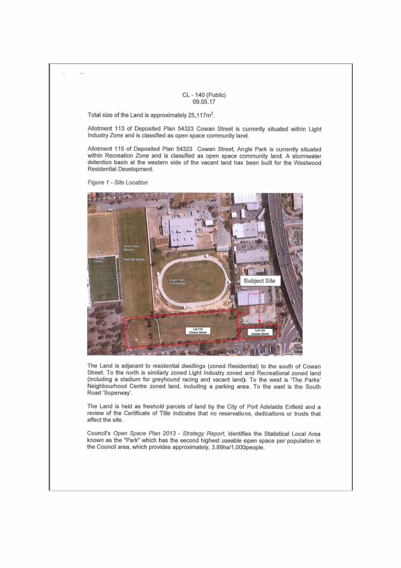
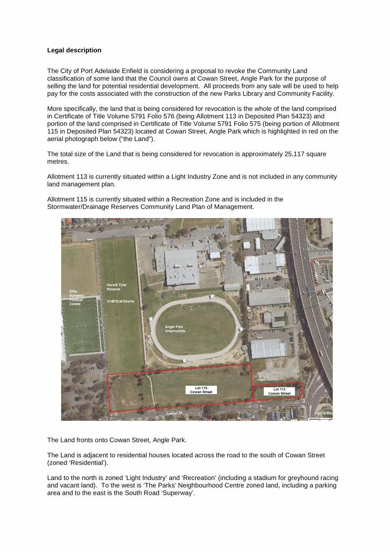
The City of Port Adelaide Enfield is considering a proposal to revoke the Community Land classification of some land that the Council owns at Cowan Street, Angle Park for the purpose of selling the land for potential residential development. All proceeds from any sale will be used to help pay for the costs associated with the construction of the new Parks Library and Community Facility. More specifically, the land that is being considered for revocation is the whole of the land comprised in Certificate of Title Volume 5791 Folio 576 (being Allotment 113 in Deposited Plan 54323) and portion of the land comprised in Certificate of Title Volume 5791 Folio 575 (being portion of Allotment 115 in Deposited Plan 54323) located at Cowan Street, Angle Park which is highlighted in red on the aerial photograph below (“the Land”). The total size of the Land that is being considered for revocation is approximately 25,117 square metres. Allotment 113 is currently situated within a Light Industry Zone and is not included in any community land management plan. Allotment 115 is currently situated within a Recreation Zone and is included in the Stormwater/Drainage Reserves Community Land Plan of Management.
The Land fronts onto Cowan Street, Angle Park. The Land is adjacent to residential houses located across the road to the south of Cowan Street (zoned ‘Residential’). Land to the north is zoned ‘Light Industry’ and ‘Recreation’ (including a stadium for greyhound racing and vacant land). To the west is ‘The Parks’ Neighbourhood Centre zoned land, including a parking area and to the east is the South Road ‘Superway’.


Deposited Plan 54323


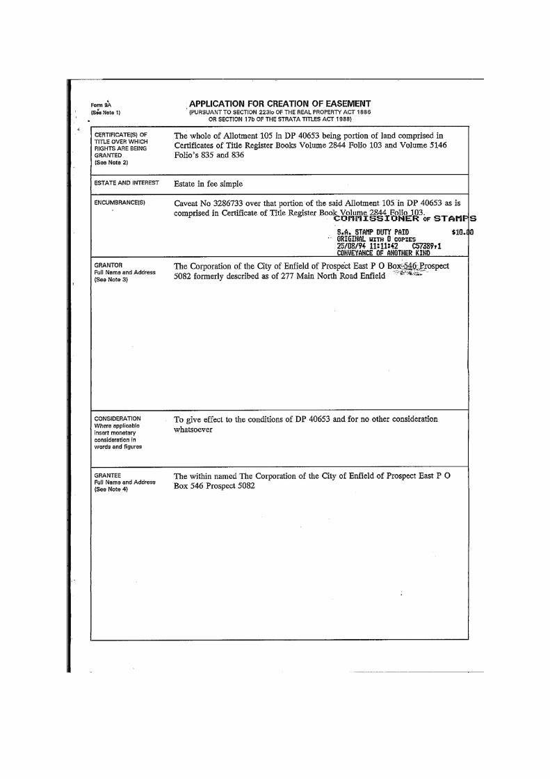
Easements
Application for Creation of Easement (registered document number 3166076)


Easements
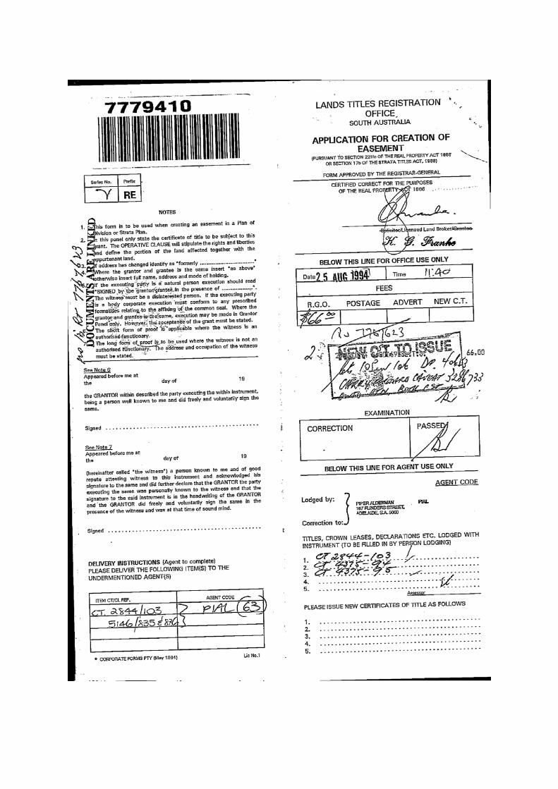
Application for Creation of Easement (registered document number 7779410)


Section 3
Public Consultation
Public notices
* The Advertiser, 13 July 2017 * Westside Weekly Messenger, 19 July 2017
Other publicity material
* Brochure * Information on Council’s Website
Revocation sign installed on the site
* Sign * Sign location

Public notice
Published in The Advertiser on 13 July 2017 and the Westside Weekly Messenger on 19 July 2017

Public information brochure


Information on Council’s website

Revocation of community land - Cowan Street, Angle Park
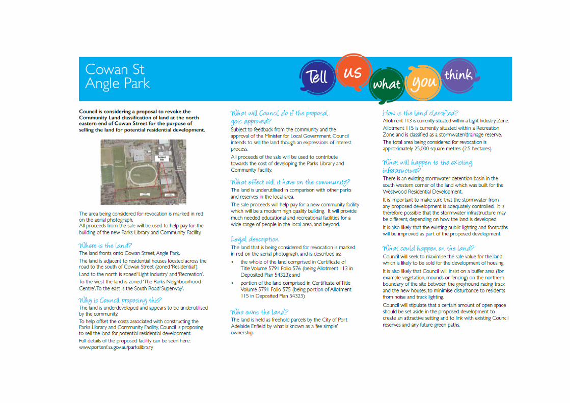
Council is considering the revocation of the Community Land classification of the area marked in red on the photograph below. The land is currently underdeveloped and not used as frequently as other reserves in the local area and Council is looking for funds to help offset the costs of building a new community facility. Council will seek to maximise the sale value for the land which may be sold for potential housing development.
All proceeds from the sale of this land will be used to help pay for the building of the Parks Library and Community Facility.
The land fronts onto Cowan Street, Angle Park.
The land is adjacent to residential houses located across the road to the south of Cowan Street (zoned ‘Residential’).
Land to the north is zoned ‘Light Industry’ and ‘Recreation’ (including a stadium for greyhound racing and vacant land).
To the west the land is zoned ‘The Parks Neighbourhood Centre’, including a parking area.
To the east is the South Road ‘Superway.
The total area being considered for revocation is approximately 25,000 square metres.
Community and stakeholder engagement
We recognise the importance of hearing from our community to ensure this process meets the needs of our community both now and into the future. A key part of the revocation process is engagement with stakeholders and the community. You are invited to provide your view on Council’s proposal to revoke the Community Land classification of land located at Cowan Street, Angle Park.

How can I get involved? The consultation period will begin on 13 July 2017 and close on Friday 11 August 2017
You can provide feedback by:
• Writing to: Kym Jackson City of Port Adelaide Enfield PO Box 110 Port Adelaide SA 5015
• Submitting a letter to Council or your comments via email on [email protected]
WHAT HAPPENS TO MY FEEDBACK?
The comments from this public consultation will be collated and presented in a report to Council.
Details about the revocation proposal can be seen in a Report that is available on this website or at Council offices. The Report describes the proposal, the reasons behind it, where the land is located and the possible future use of the land.
The public has 4 weeks to provide their views and opinions to Council about the revocation proposal.
Following the completion of public consultation, a report will be presented to Council with the results of the consultation for Council to consider and to decide whether to continue the process to revoke the Community Land classification of this land.
Frequently asked questions
Why is Council proposing this?
To help offset the costs associated with constructing the Parks Library and Community Facility, Council is proposing to sell the land for potential residential development.
This new community facility will be a modern high quality building. It will provide much needed educational and recreational facilities for a wide range of people in the local area, and beyond.
Full details of the proposed facility can be seen here: http://www.portenf.sa.gov.au/parkslibrary
What will Council do if the proposal gets approved?
Subject to feedback from the community and the approval of the Minister for Local Government, Council intends to sell the land though an open sales process by inviting expressions of interest.
All proceeds of the sale will be used to contribute towards the cost of developing the Parks Library and Community Facility.
What could happen on the land?
Depending on the response from the community it is likely that the land will be developed for housing.
It is also likely that Council will insist on a buffer area (for example vegetation, mounds or fencing) on the northern boundary of the site between the greyhound racing track and the new houses, to minimise disturbance to residents from noise and track lighting.
Council will stipulate that a certain amount of open space should be set aside in the proposed development to create an attractive setting and to link with existing Council reserves.

What effect will it have on the community?
The land appears to be underdeveloped with low amenity and low value vegetation. It is underutilised in comparison with other parks and reserves in the local area.
The sale proceeds will help pay for a new community facility which will be a modern high quality building. It will provide much needed educational and recreational facilities for a wide range of people in the local area, and beyond.
What will happen to the existing infrastructure?
There is an existing stormwater detention basin in the south western corner of the land which was built for the Westwood Residential Development. It is important to make sure that the stormwater from any proposed development is adequately controlled. It is therefore possible that the stormwater infrastructure may be different, depending on how the land is developed. The way in which the stormwater is managed may therefore change.
It is also likely that the existing public lighting and footpaths will be improved as part of the proposed development.
How is the land classified?
The land is held as freehold parcels by the City of Port Adelaide Enfield by what is known as a ‘fee simple’ ownership.
Allotment 113 is currently situated within a Light Industry Zone.
Allotment 115 is currently situated within a Recreation Zone and is classified as a stormwater/drainage reserve.
Legal description
The land that is being considered for revocation is marked in red on the aerial photograph, and is described as:
• the whole of the land comprised in Certificate of Title Volume 5791 Folio 576 (being Allotment 113 in Deposited Plan 54323) and
• portion of the land comprised in Certificate of Title Volume 5791 Folio 575 (being portion of Allotment 115 in Deposited Plan 54323)
What is the history behind this land?
Land grants for this area were originally issued to farmers in the 1850s and often inherited by their children, one of which was Hubert Hurtle Schillabeer, who inherited his father’s land in the early 1920s and progressively sold small portions of land to other individuals during the 1920s.
Some of this land was purchased by the South Australian Housing Trust in the late 1940s and throughout the 1950s and subsequently purchased by The Corporation of the City of Enfield in late 1960 and the early 1970s.
Part of this housing trust land was also purchased by The Electricity Trust of South Australia in the early 1950s and sold onto to farmers who ultimately transferred land to The Corporation of the City of Enfield.
What is community land?
Most land that is owned by Council or under its care and control is set aside for the public to use and enjoy.
This land is classified as “Community Land” to make sure it is looked after for the benefit of the whole community and to reflect that some land has special meaning to locals because of important cultural or historic features. Council is responsible for actively managing this land.
Council’s overall goal is to create a vibrant and attractive city that is well-planned, with safe and healthy places to live, work and play. When it plans ahead, Council takes into account changing population demographics (in particular ageing), changing community needs and shifts in leisure trends such as the increasing demand for structured recreation activities.

Over time community expectations and priorities change about how Community Land should be used and there are competing demands for its use. Council needs to consider all of these demands and the best way to use ratepayers’ money in a way that benefits the most people.
Sometimes councils need to consider whether it is in the long term interests of their community that the protection of a parcel of land under the classification of Community Land continues or not. Councils (in consultation with the community) may decide that such protection under this classification is no longer required, to enable the land to be sold and the proceeds used for another community purpose, such as building a community facility.
One of Council’s key priorities is to provide community facilities that will benefit as many people as possible in the local community. The new Parks Library and Community Facility is an example of such a facility. However, the cost of building this complex is significant, and Council needs to find some extra money to fund it. It is also important that Council balances its books. Council is therefore considering a proposal to sell some Community Land to help pay for this facility.
How is community land revoked?
The Local Government Act 1999 contains important restrictions on the ability of Council to sell its Community Land. Community Land cannot be sold without first consulting with the broader community and giving the public an opportunity to consider any proposal to sell the land. Council must take into account the views and opinions of the public when Council makes its decision as to whether it will revoke the Community Land status of the land.
There is a further step in the process. The Minister for Local Government must also consider the overall merits of the proposal and decide whether to consent to the revocation and sale and give Council the authority to proceed.
What happens to the feedback provided by the public?
A copy of any written feedback is included in a report that will be presented to the elected members of Council. Council members must consider what the community has to say about the proposal, when they decide whether to make an application to the Minister for his approval.
If Council decides to apply for the Minister’s approval, a report must be provided to the Minister that includes a copy of every public submission made during the course of the public consultation. The process of consulting the public and its results is an important factor in the Minister’s decision whether to approve the proposal or not. The Minister has the discretion to decide one way or the other.
If the Minister approves Council’s application, this consent gives Council the authority to pass a resolution to revoke the classification of the land as Community Land. Once that resolution is made, then the sale process can start.
The revocation of the Community Land classification does not take effect unless Council makes a resolution to give effect to the proposal. Council may decide that it does not wish to proceed with the resolution.

Distribution map for letter drop off to nearby owners and occupiers

Revocation sign stalled at the site
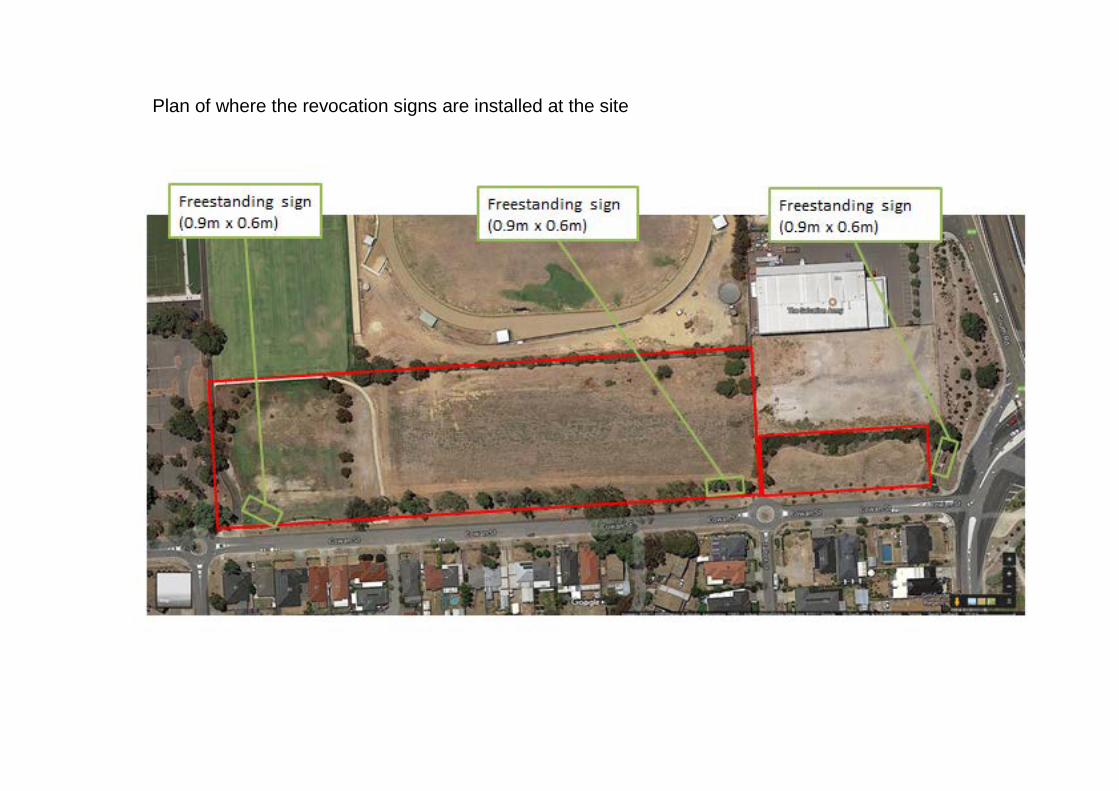
Plan of where the revocation signs are installed at the site

Report on the revocation of classification as community land

City of Port Adelaide Enfield
Report on the revocation of classification as community land
Section 194 of the Local Government Act 1999
Report on the proposal to revoke the Community Land classification of the whole of the land comprised in Certificate of Title Volume 5791 Folio 576 (being Allotment 113 in Deposited Plan 54323) and portion of the land comprised in Certificate of Title Volume 5791 Folio 575 (being portion of Allotment 115 in Deposited Plan 54323), located at Cowan Street, Angle Park
Reasons for the proposal One of Council’s key priorities is to provide community facilities that will benefit as many people as possible in the local community. The new Parks\ Library and Community Facility is an example of such a facility. However, the cost of building this complex will involve further expenditure of Council funds. Council will be spending almost $8 million on the new Parks Library and Community Facility. It is highly unlikely that this project will attract significant external funding. To enable this project to proceed, Council will need to borrow the majority of the funds unless it can offset the expenditure through the sale of other assets. Council is therefore considering a proposal to revoke the Community Land classification of some land that the Council owns at Cowan Street, Angle Park. This land is currently underdeveloped and not used as frequently as other reserves in the local area and the sale proceeds could help offset the costs of building the new Parks Library and Community Facility. Council will seek to maximise the sale value for the land which is likely to be sold for the development of housing. More specifically, the land that is being considered for this proposal is described as the whole of the land comprised in Certificate of Title Volume 5791 Folio 576 (being Allotment 113 in Deposited Plan 54323) and portion of the land comprised in Certificate of Title Volume 5791 Folio 575 (being portion of Allotment 115 in Deposited Plan 54323) (the ‘Land’). How will the proposal affect the local community? The Land is currently under-utilised by the local community in comparison with other parks and reserves in the local area and appears underdeveloped for recreational use with low amenity and low value vegetation. It is considered that the local community often prefers to use other existing recreational facilities at Regency Park Reserves and nearby Parks Community Centres, which offer easy access to parking, recreational/sports facilities, community centre, lighting, shelters, benches and public toilets, etc. Although there will be a reduction in the open space in the area, the sale proceeds will be used to contribute towards the cost of the construction of a library community facility which will have a positive social impact on residents in the surrounding suburbs and more generally and provide much needed recreational and educational opportunities currently not available within the area. Council considers revocation of the Land and the potential residential development will offer significant benefits to the community and Council, including: • proceeds of the land sale would fund the construction of the new Parks Library and Community
Facility, which is one of the Council’s key commitments for 2017/18 and 2018/19; • the provision of a fully integrated residential development with existing and future community
services; • a possible increase in affordable housing stock in the local area to cater for the low income and
disadvantage community;

• an improvement to existing assets, including stormwater management infrastructure, public lighting, footpaths, etc; and
• an improved quality and amenity of the open space in the area to create a safe, clean, healthy and attractive environment for local community and general public.
An indicative market value of the Land (25,117 square metres) could be exceeding $3,900,000 ($3.9 million) if the land was able to be developed as residential. The Report to Council at its meeting on 9 May 2017 contains more detailed information about open space, affordable housing and market values. See Section 4 of this Report. What are the benefits of the Parks Library and Community Facility? The proposed design of this new facility is expected to provide significant social benefits, such as providing a place where people: • from diverse backgrounds will feel celebrated and have a strong sense of belonging; • enjoy good physical, social, mental and emotional wellbeing and have access to support,
resources and experiences; • feel welcomed and included and have the opportunity to contribute meaningfully in their
neighbourhood; • embrace and explore opportunities for social and economic improvement. In addition to the library resources and services, the Parks Library and Community Facility will offer an inclusive community environment and a wide range of social activities and outreach services. The new facility is designed to promote opportunity for group social activities at the facility for people with disabilities. The Parks Library and Community Facility will offer a superior level of accessibility to the new Library & Community facility for disabled visitors and their carers. The facility will contain an accredited Changing Places facility which will be the first of its kind in South Australia. In terms of equal access and inclusion principles, it is more beneficial for the changing facility to be located within the new library than in an adjacent building such as the sports centre. Preliminary plans are also being developed to include improvements that need to be made to the existing roads, footpaths and parking arrangements. The current roads, footpaths and parking layouts need to be upgraded to be able to provide a pedestrian friendly link between the facilities at the Parks Library and Community Facility, whilst making vehicular access better and parking easier. The latest proposed design of the Parks Library and Community Facility will also contribute to all five goals in the City Plan It will be a place to access learning and information, a place for meetings, cultural celebrations, education programs, borrow books, toys and movies, to explore history and heritage, to have fun, to socialise, to volunteer, to learn about and access technology and to be welcomed, included and safe. What is the history behind this land? Land grants for this area were originally issued to farmers in the 1850s and often inherited by their children, one of which was Hubert Hurtle Schillabeer, who inherited his father’s land in the early 1920s and progressively sold small portions of land to other individuals during the 1920s. Some of this land was purchased by the South Australian Housing Trust in the late 1940s and throughout the 1950s and subsequently purchased by The Corporation of the City of Enfield in late 1960 and the early 1970s. Part of this housing trust land was also purchased by The Electricity Trust of South Australia in the early 1950s and sold onto to farmers who ultimately transferred land to The Corporation of the City of Enfield. It appears that no Government Assistance was given to acquire the various parcels of land.

What is the zoning of the land? Allotment 113 is presently zoned ‘Light Industry’. Allotment 115 is currently zoned ‘Recreation’. The zone objectives promote sporting and recreation activities and the maintenance and enhancement of existing trees and vegetation. The Land is adjacent to residential houses located across the road to the south (zoned ‘Residential’). To the north the land nearby is zoned ‘Light Industry’ and ‘Recreation’ (including a stadium for greyhound racing and vacant land). To the west the land is zoned ‘The Parks Neighbourhood Centre’, including a parking area. To the east is the South Road ‘Superway’. The relevant zoning can be seen in the plan below.
Are there any registered interests over the land? There is an existing registered service easement for drainage purposes over part of Allotment 115 in favour of the City of Port Adelaide Enfield, and the ownership rights of this parcel of land are subject to this easement. This easement gives the Council the right to enter the easement area at any time and to use the area for laying drains, drainage pipes or other infrastructure and for checking, maintaining and repairing that infrastructure. Dedication, reservation or trust to which the land is subject The Land is held as freehold parcels by the City of Port Adelaide Enfield by what is known as a ‘fee simple’ ownership. The Land is not subject to any known Crown Land dedication, reservation or trust. Allotment 113 is not included in any community land management plan. In 2000, Allotment 113 became a reserve by virtue of the Real Property Act 1886 as part of a plan of division and is not subject to any other known dedication, reservation or trust. Allotment 115 is included in the Stormwater/Drainage Reserves Community Land Plan of Management. It is not subject to any known dedication, reservation or trust.

What will happen to the existing infrastructure? There is an existing stormwater detention basin in the south western corner of the land fronting onto Cowan Street which was built for the Westwood Residential Development. It is important to make sure that the stormwater from any proposed development is adequately controlled. It is therefore possible that the stormwater infrastructure may be different, depending on how the land is developed. It is also likely that the existing public lighting and footpaths will be improved as part of the proposed development. Council's Strategic Business Plan recommends the construction of a shared path along the northern side of Cowan Street and accordingly space would need to be set aside for this proposal to be implemented. The majority of the shared path can be accommodated within the road reserve with only a small portion or the existing allotments requiring a minor boundary re-alignment to allow for the path to wrap around the northern side of the Talbot Street/Cowan Street roundabout. What could happen on the land if it is sold? Depending on the response from the community, it is likely that the land will be developed for housing. Under the current zoning, any residential development is likely to be considered by a planning authority as a non-complying form of development. If residential development was contemplated, such development would either need to involve a non-complying development application process or a prior Development Plan Amendment (rezoning) process, to enable housing to be built on the site. Any proposed development would need to be able to demonstrate that it would not adversely affect or constrain the continued existing operation of the adjacent uses. In addition, some measures may be recommended to minimise disturbance to residents and to include a certain amount of open space to create an attractive setting and to link with existing Council reserves. Written submissions (including opinions, views and letters) should be addressed to: Director City Assets City of Port Adelaide Enfield PO Box 110 PORT ADELAIDE SA 5015 Attention: Kym Jackson Residents may request further details on the proposal to be posted to them by contacting Kym Jackson on telephone 8405 6600 or email: [email protected].

Section 4
Council Documents
Minute – Item 12.2.4 for Council meeting held on 9 May 2017