rex j. fleming ucar april 21, 2003orlando
DESCRIPTION
National Environmental Observing System to Mitigate the Effects of Nuclear-Biological-Chemical (NBC) Attacks: Strategic and Tactical. Rex J. Fleming UCAR April 21, 2003Orlando. Contaminated Plumes from NBC Terrorism. Source: Nuclear or radiation device Truckload of Anthrax - PowerPoint PPT PresentationTRANSCRIPT
National Environmental Observing System to Mitigate the Effects of Nuclear-Biological-
Chemical (NBC) Attacks: Strategic and Tactical
Rex J. Fleming
UCAR
April 21, 2003 Orlando
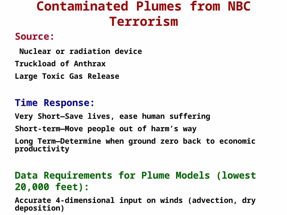
Contaminated Plumes from NBC Terrorism
Source:
Nuclear or radiation device
Truckload of Anthrax
Large Toxic Gas Release
Time Response:Very Short—Save lives, ease human suffering
Short-term—Move people out of harm’s way
Long Term—Determine when ground zero back to economic productivity
Data Requirements for Plume Models (lowest 20,000 feet):Accurate 4-dimensional input on winds (advection, dry deposition)
Accurate 4-dimensional input on water vapor and temperatures (stability, wet deposition, moist physics/chemistry, etc.)

Potentially Dangerous Chain of Events
• Plume models driven by Mesoscale Models• Mesoscale (high resolution in space and time)
models: highly volatile, extremely sensitive to quality and quantity of initial data
• Above results in a wide spectrum of results in short time period– stable predicted as unstable and vice versa– convective weather lines moving too fast or too
slow– moisture regions geographically misplaced and
intensity wrong by factor of two or more

Stable Unstable
Strong Winds
Weak Winds
less intense
more area affected
more intense
less area affected
least intense
least area affected (locally)
Impact of Atmospheric Stability on Contaminant Plumes

• Current upper air data (radiosonde system)– 350 km average horizontal resolution– two/day (12-hour) temporal resolution– Large errors in system movement due to advection
uncertainty– Very large error if systems developing or
dissipating• No high resolution data input
poor mesoscale (high resolution) model outputpoor plume model input
poor plume model guidancepotential large loss of life - needlessly
Potentially Dangerous Chain of Events (continued)

National Strategic Observing System:
- Serves entire country prior to an NBC event.
- Provides 4-D high resolution input as most powerful information source at location and time of NBC terrorist event
- Allows time (2-4 hours) for Tactical Observing System to be brought into ground zero
- Further supports Tactical System in determining radioactive fallout in case of nuclear event (near-surround vs. far-surround)
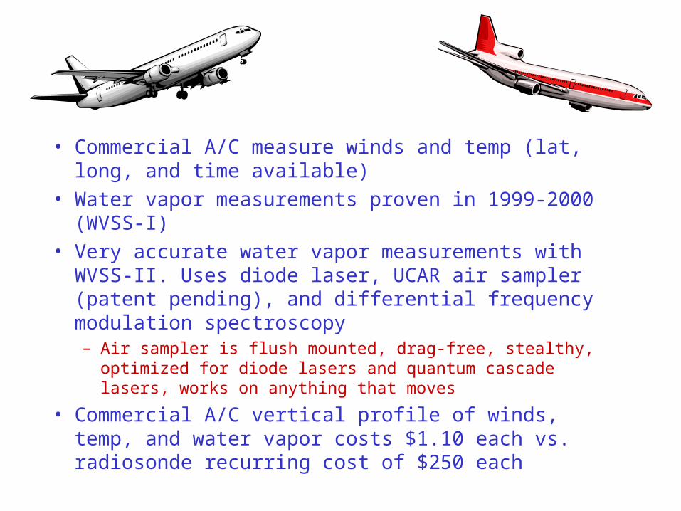
• Commercial A/C measure winds and temp (lat, long, and time available)
• Water vapor measurements proven in 1999-2000 (WVSS-I)
• Very accurate water vapor measurements with WVSS-II. Uses diode laser, UCAR air sampler (patent pending), and differential frequency modulation spectroscopy– Air sampler is flush mounted, drag-free, stealthy, optimized for
diode lasers and quantum cascade lasers, works on anything that moves
• Commercial A/C vertical profile of winds, temp, and water vapor costs $1.10 each vs. radiosonde recurring cost of $250 each

Figure 2. Cross section of complete sampler
Turbulence enhancer
Cylindrical sampling tube
Inertial separator (inside, see Fig. 3)
Aircraft skin
8.89 cm
24 cm


WVSS-II Lifetime Costs (20 Years) Per Aircraft
Purchase and Installation $18,000
Maintenance ($2,000 every two years) 20,000
Comms. Cost ($1,600/year/aircraft) 32,000
Total $70,000
Profiles: (10/day)(320 flight days/year)(20 years) = 64,000
Price per profile = $1.10

Tactical Observing System:(staged throughout country serving dual benefits – one is NBC terrorism event)
- Consists of a variety of systems: function of (nuclear, biological, or chemical)
- Includes existing satellite systems and systems brought in by first responders
- Measures 4-D area around ground zero and near-surround
- Consists of highly mobile systems (aerial and ground-based)
- Measures environment and contaminated plume (composition, strength, 4-D movement, trends)

Ground Mobile Systems
- trucks/vans
- all-terrain Hummers
- fast moving choreographed array for environmental data
- optimally positioned array for species identification, concentration and trends

Figure 4: Cartoon showing a possible ground-based mobile platform configuration [the concentric circles shown are only symbolic as the actual paths for the ground mobile systems would be polygons of available paths (streets and/or fields) that could be traversed].

Aerial Mobile Observational Platforms:
Special Manned Aircraft
- Some existing government a/c
- Some existing university and government research a/c
- Some existing older commercial a/c suitable for purpose
Unmanned Aerial Vehicles (UAV)
- Range from GNAT (48 hr endurance and 140 lb payload) to GlobalHawk (42 hr endurance and 1960 lb payload)
- Smaller, simpler, in-situ data and plume info only

National Strategic Observing Systems to Help Mitigate Effects of NBC Terrorism
Principal Investigators:
Rex J. Fleming (UCAR)Tom Warner (NCAR)
Draft of May 27, 2003
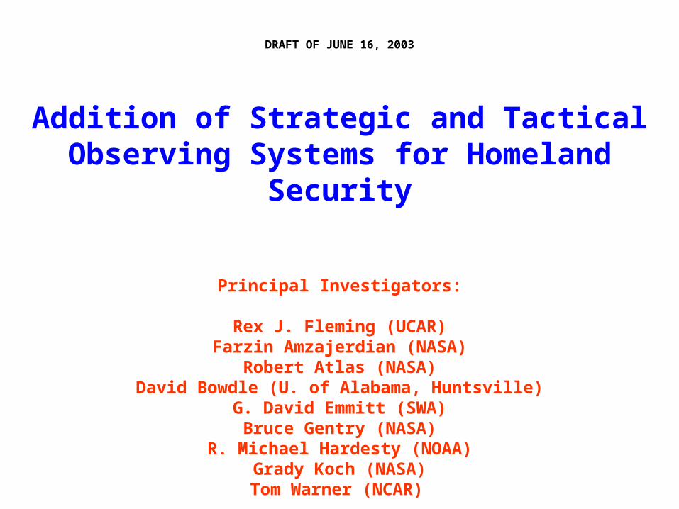
DRAFT OF JUNE 16, 2003
Addition of Strategic and Tactical Observing Systems for Homeland Security
Principal Investigators:
Rex J. Fleming (UCAR)Farzin Amzajerdian (NASA)
Robert Atlas (NASA)David Bowdle (U. of Alabama, Huntsville)
G. David Emmitt (SWA)Bruce Gentry (NASA)
R. Michael Hardesty (NOAA)Grady Koch (NASA)Tom Warner (NCAR)
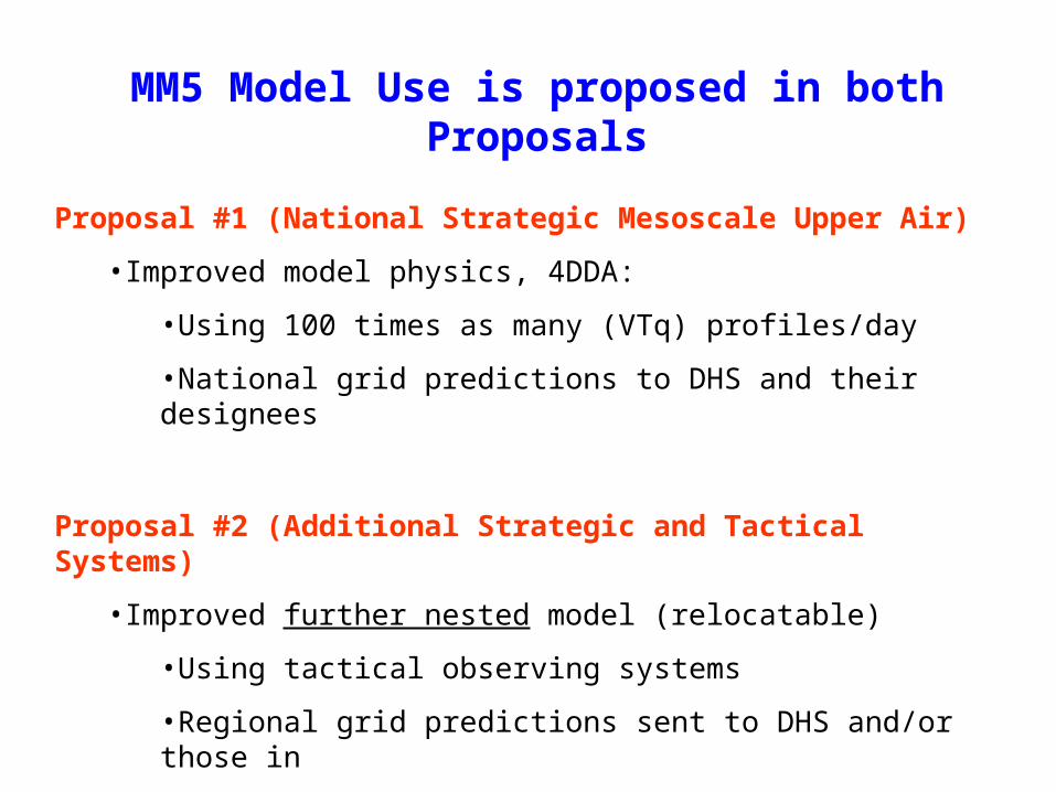
MM5 Model Use is proposed in both Proposals
Proposal #1 (National Strategic Mesoscale Upper Air)
•Improved model physics, 4DDA:
•Using 100 times as many (VTq) profiles/day
•National grid predictions to DHS and their designees
Proposal #2 (Additional Strategic and Tactical Systems)
•Improved further nested model (relocatable)
•Using tactical observing systems
•Regional grid predictions sent to DHS and/or those in
charge of ground zero operations

Mesoscale Aircraft Network
OtherFederal Users
NWS /NCEP
ARINC
delayed q.c.feedback
NEW
MM5Model Runs
All OtherUsers
High ResolutionData
from Carriers
delayed q.c.data
Later (new)
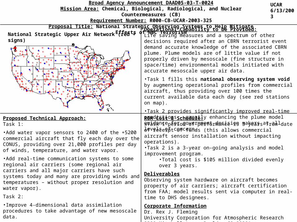
Broad Agency Announcement DAAD05-03-T-0024Mission Area: Chemical, Biological, Radiological, and Nuclear Countermeasures (CB)
Requirement Number: R000-CB-UCAR-2003-325Proposal Title: National Strategic Observing Systems to Help Mitigate Effects of NBC Terrorism
Proposed Technical Approach:Task 1:
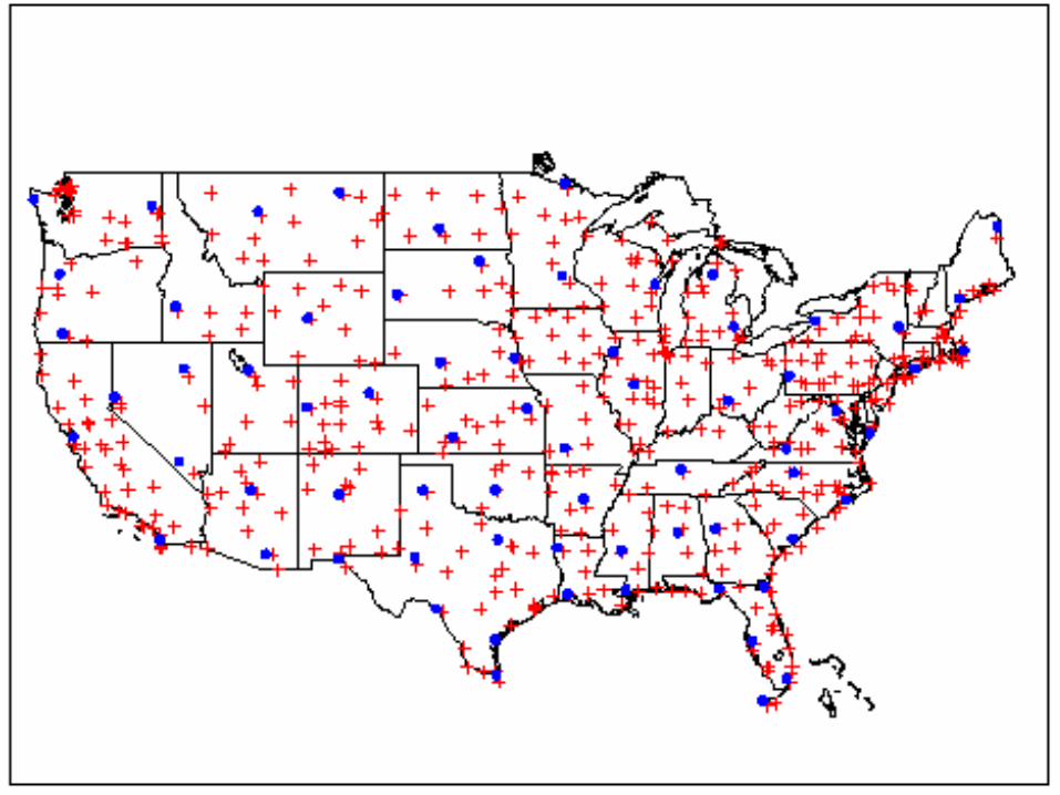
•Add water vapor sensors to 2400 of the +5200 commercial aircraft that fly each day over the CONUS, providing over 21,000 profiles per day of winds, temperature, and water vapor.
•Add real-time communication systems to some regional air carriers (some regional air carriers and all major carriers have such systems today and many are providing winds and temperatures – without proper resolution and water vapor).
Task 2:
•Improve 4-dimensional data assimilation procedures to take advantage of new mesoscale data.
•Improve NCAR MM5 model (currently providing 24x7 model results to US Army) with better physics and data.
Operational Capability to be Provided:Life saving measures and a spectrum of other decisions required after an CBRN terrorist event demand accurate knowledge of the associated CBRN plume. Plume models are of little value if not properly driven by mesoscale (fine structure in space/time) environmental models initiated with accurate mesoscale upper air data.
•Task 1 fills this national observing system void by augmenting operational profiles from commercial aircraft, thus providing over 100 times the current available data each day (see red stations on map).
•Task 2 provides significantly improved real-time predictions – greatly enhancing the plume model guidance for government decision makers at all levels of concern.
ROM Cost & Schedule:•Task 1 period of performance is 3 years from date of receipt of funds (this allows commercial aircraft sensor installation without impacting operations).•Task 2 is a 3-year on-going analysis and model improvement program.
•Total cost is $105 million divided evenly over 3 years.
DeliverablesObserving system hardware on aircraft becomes property of air carriers; aircraft certification from FAA; model results sent via computer in real-time to DHS designees.
Corporate InformationDr. Rex J. FlemingUniversity Corporation for Atmospheric Research3300 Mitchell Lane, Boulder CO 80301Phone (303)497-8165 Fax (303)497-8158 Email [email protected]
National Strategic Upper Air Network (red + signs)
UCAR6/13/2003

Broad Agency Announcement DAAD05-03-T-0024Mission Area: Chemical, Biological, Radiological, and Nuclear Countermeasures (CB)
Requirement Number: R000-CB-UCAR-2003-326Proposal Title: Addition of Strategic and Tactical Observing Systems for Homeland Security
Proposed Technical Approach:Task 1:•Add automatic ground based Doppler wind profilers at major coastal cities for possible coastal nuclear detonations.•Add proven hand-held devices for measuring plume composition to air mobile (special manned aircraft and UAVs) and ground mobile platforms (trucks/vans and all-terrain Hummers). Also add environmental sensors for wind, temperature, and water vapor to above mobile platforms.
Task 2:•Improve 4-dimensional data assimilation procedures for the small regional movable grid required to monitor/predict conditions following a terrorist event.•Implement relocatable finer scale version of national NCAR MM5 model to be major information source for ground zero operations
Operational Capability to be Provided:Once a CBRN even has occurred the contaminated plume will continue to evolve due to a number of dynamical, chemical, and physical processes. A mobile tactical observing system is required to measure both the environment and the plume near ground zero and the near-surround. Several tactical observing system configurations are pre-staged at locations around the country. This information is crucial for all subsequent actions and decisions – including those involved in saving lives.
Task 1 implements new observations at key coastal cities and mobile tactical observing systems for both the plume and the environment (ground-based, special manned aircraft, and UAVs).
Task 2 provides detailed regional model results for the region of the CBRN event.
Cartoon showing a possible ground-based mobile platform configuration [the concentric circles shown are only symbolic as the actual paths for the ground mobile systems would be polygons of available paths (streets and/or fields) that could be traversed].
ROM Cost & Schedule:(This is a large interagency effort lead by UCAR)•Task 1 period of performance is 3 years from date of receipt of funds (this allows time to select and equip the 30 regional hubs around the country).•Task 2 is a 3-year on-going analysis and model improvement program.
•Total cost is $138 million evenly divided over 3 years.
DeliverablesObserving system hardware; data and model results sent to DHS and/or ground zero operations center in real-time.
Corporate InformationDr. Rex J. FlemingUniversity Corporation for Atmospheric Research3300 Mitchell Lane, Boulder CO 80301Phone (303)497-8165 Fax (303)497-8158 Email [email protected]
UCAR6/13/2003
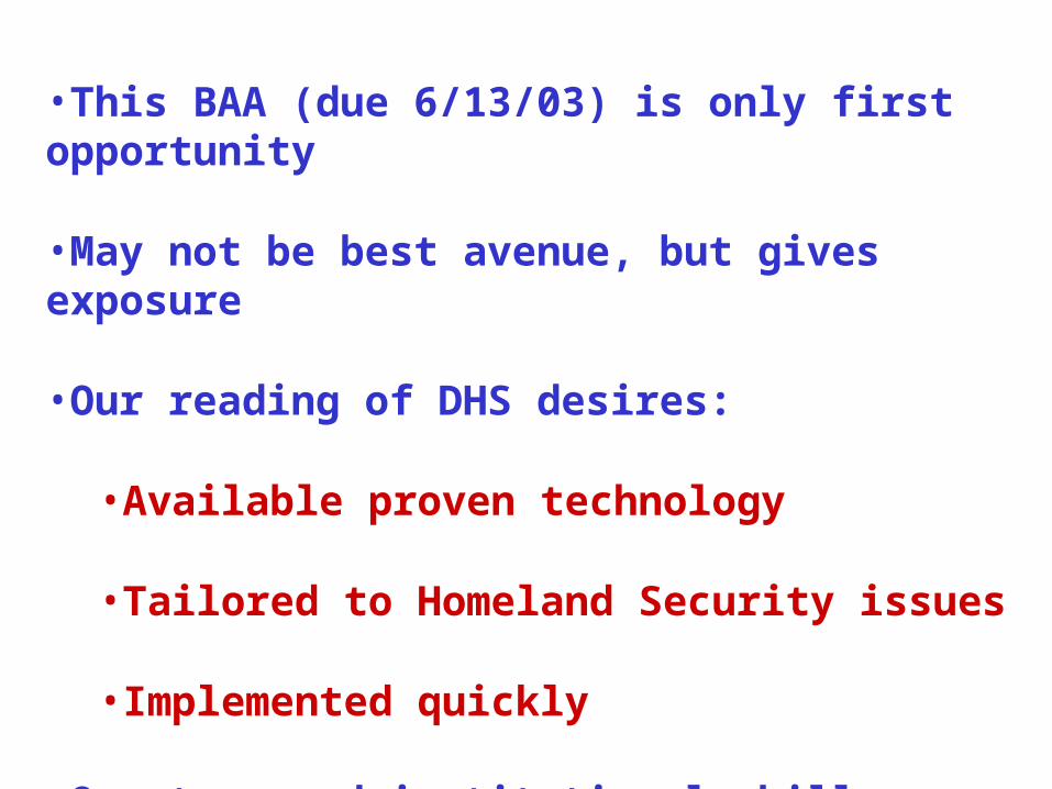
•This BAA (due 6/13/03) is only first opportunity
•May not be best avenue, but gives exposure
•Our reading of DHS desires:
•Available proven technology
•Tailored to Homeland Security issues
•Implemented quickly
•Our team and institutional skill can get job done

BUDGET for National Strategic Upper Air Obsrving System (thousands of dollars)
FY 2004 FY2005 FY2006 FY2007 TOTAL
Non-recurring costsWVSS-II units (2400) 14400 14400 14400 43200
Comms: Regional A/C (600) 10000 10000 10000 30000
Turboprop software/comms 600
Certification expense 500 500 1000
TOTAL 25500 24900 24400 74200
Recurring costs
Comms 2500 4500 6500 6500 20000
Maintenance 1600 2400 4000
4DDA Improvement 400 400 500 1300
MM5 Model Implementation 400 300 300 200 1200
UCAR Project Support 850 900 950 1000 3700
TOTAL 4150 6100 9850 10100 30200
TOTAL TOTAL 29650 31000 34250 10100 105000

BUDGET SUMMARY: ADDITIONAL STRATEGIC and TACTICAL OBSERVING SYSTEMS(Thousands of dollars)
Task description FY #1 FY #2 FY#3 FY #4 Total
Wind profilers for coastal cities 4000 3000 3000 10000
Water vapor profiles at coastal cities 1000 2000 1000 4000
Commercial a/c wind profilers 2000 2000 1000 5000
WVSS-II on military aircraft 6200 5000 5000 16200
SMA wind profilers 3000 3500 3500 10000
UAV sensor package 1000 1000 1000 3000
UAV wind profilers 4000 3000 3000 10000
Vans/trucks (purchase and sensors) 8000 8000 8000 24000
Hummers (purchase and sensors) 14000 14000 14000 42000
RECURRING COSTS
Communications 500 1700 1700 3900
4DDA improvements 400 700 1100 400 2600
Model improvements 400 900 1100 400 2800
Administration costs 1000 1400 1600 500 4500
TOTAL COSTS 45000 45000 45000 3000 138000

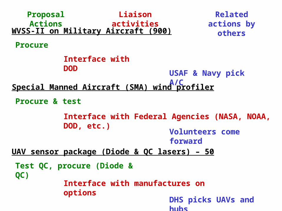
Proposal Actions Liaison activities Related actions by others
Wind profilers for 20 Coastal Cities
Procure & test
Interface with NWS
Sites selected by DHS
Water vapor profilers (DIAL or Raman) for 20 coastal cities
Procure & test
Interface with NWS
Sites selected by DHS
Commercial a/c wind profilers (20)
Develop, certify, procure & test
Interface with possible air carriers
Proposal Actions Liaison activities Related actions by others
WVSS-II on Military Aircraft (900)
Procure
Interface with DOD
USAF & Navy pick A/C
Special Manned Aircraft (SMA) wind profiler
Procure & test
Interface with Federal Agencies (NASA, NOAA, DOD, etc.)
Volunteers come forward
UAV sensor package (Diode & QC lasers) – 50
Test QC, procure (Diode & QC)
Interface with manufactures on options
DHS picks UAVs and hubs

Proposal Actions Liaison activities Related actions by others
UAV Wind Profilers (50)
Develop, certify, procure
Interface with manufactures on options
DHS picks UAVs and hubs
Vans/trucks (purchase [all or some] and sensors 10 each @ 30 sites)
Determine sensor location, purchase, equip, test
Interface with manufactures
DHS selects 30 regional hubs
Hummers (purchase [all or some] and sensors 10 each @ 30 sites)
Determine sensor location, purchase, equip, test
Interface with manufactures
DHS selects 30 regional hubs