rezoning from ra to rh and cd (based on rh-g) in order to ... · pdf filera lots to the east...
TRANSCRIPT

City of Surrey PLANNING & DEVELOPMENT REPORT
File: 7913-0093-00
Planning Report Date: September 09, 2013
PROPOSAL:
• Rezoning from RA to RH and CD (based on RH-G)
in order to allow subdivision into three (3) lots.
LOCATION: 14665 - 28 Avenue
OWNER: James L Shannon
ZONING: RA
OCP DESIGNATION: Suburban
LAP DESIGNATION: One Acre

Staff Report to Council File: 7913-0093-00
Planning & Development Report
Page 2 RECOMMENDATION SUMMARY • By-law Introduction and set date for Public Hearing for Rezoning DEVIATION FROM PLANS, POLICIES OR REGULATIONS • The subject site is designated "One Acre" in the Central Semiahmoo Peninsula Local Area Plan
(LAP). The Applicant is proposing to amend the Central Semiahmoo Peninsula LAP from "One Acre" to "Half-Acre Gross Density".
RATIONALE OF RECOMMENDATION • Complies with OCP Designation. • The application is consistent with development immediate to the west and to the north.
Under application No. 7903-0268-00 to the immediate west, the LAP was amended from "Suburban One Acre" to "Half-Acre Gross Density" and the proposed rezoning and subdivision continues that pattern.

Staff Report to Council File: 7913-0093-00
Planning & Development Report
Page 3 RECOMMENDATION The Planning & Development Department recommends that: 1. A By-law be introduced to rezone the subject site as shown on the Rezoning Block Plan
(Appendix II) as follows: • Block A from "One-Acre Residential Zone (RA )" (By-law No. 12000) to
"Comprehensive Development Zone (CD)" (By-law No. 12000) (based on RH-G);
• Block B from "One-Acre Residential Zone (RA )" (By-law No. 12000) to "Half-Acre Residential Zone (RH)" (By-law No. 12000);
and a date be set for Public Hearing.
2. Council instruct staff to resolve the following issues prior to final adoption:
(a) ensure that all engineering requirements and issues including restrictive covenants, dedications, and rights-of-way where necessary, are addressed to the satisfaction of the General Manager, Engineering;
(b) submission of a subdivision layout to the satisfaction of the Approving Officer; (c) submission of a finalized tree survey and a statement regarding tree preservation
to the satisfaction of the City Landscape Architect; (d) the applicant addresses the shortfall in tree replacement; (e) submission of a landscaping plan and landscaping cost estimate to the
specifications and satisfaction of the Planning and Development Department; (f) the applicant address the concern that the development will place additional
pressure on existing park facilities to the satisfaction of the General Manager, Parks, Recreation and Culture;
(g) demolition of existing buildings and structures to the satisfaction of the Planning
and Development Department; and (h) applicant address the 15% cash in lieu of open space associated with gross density
type lots, for the CD By-Law zoned lot.
3. Council pass a resolution to amend the Central Semiahmoo Peninsula Local Area Plan to
redesignate the land from Suburban 1 Acre to Suburban ½ Acre when the project is considered for final adoption.

Staff Report to Council File: 7913-0093-00
Planning & Development Report
Page 4 REFERRALS Engineering: The Engineering Department has no objection to the project
subject to the completion of Engineering servicing requirements as outlined in Appendix III.
School District: Projected number of students from this development: 2 Elementary students at Semiahmoo Trail Elementary School 1 Secondary students at Semiahmoo Secondary School (Appendix IV) The applicant has advised that the project is expected to be completed by Fall 2014.
Parks, Recreation & Culture:
There are concerns about the pressure this project will place on existing Parks, Recreation and Culture facilities in the neighbourhood. An appropriate amenity contribution will be necessary.
SITE CHARACTERISTICS Existing Land Use: Single family dwelling to be removed Adjacent Area:
Direction Existing Use OCP / LAP Designation Existing Zone
North (Across 28A Avenue):
Single family dwellings Suburban / Half-Acre Gross Density
RH-G
East:
Single family dwelling and Semiahmoo Trail
Suburban / Suburban 1 Acre RA
South (Across 28 Avenue):
Sunnyside Acres Urban Forest Park
Conservation / Open Space RA
West:
Single family dwellings Suburban / Half-Acre Gross Density
RH-G
JUSTIFICATION FOR PLAN AMENDMENT • The site is designated "One Acre", and applicant is proposing that the site be redesignated to
"Half-Acre Gross Density". The site area is 0.5734 hectares (1.42 acres) in size.
• The applicant proposes to rezone from "One-Acre Residential Zone (RA)" to "Half-Acre Residential Zone (RH)" and to "Comprehensive Development Zone (CD)" based on "Half-Acre Residential Gross Density Zone (RH-G)", with 15% cash-in-lieu of open space, in order to permit the subdivision of one lot into 3 lots. The density being proposed by the applicant is 5

Staff Report to Council File: 7913-0093-00
Planning & Development Report
Page 5
units per hectares (2 units per acre), which is consistent with the suburban designation in the OCP.
• The proposed redesignation is in keeping with the character and established subdivision pattern of the area. The subject site is bounded on the north and west by RH-G lots. Existing RA lots to the east have similar subdivision potential. South of the subdivision (across 28 Avenue) is the Sunnyside Acres Urban Forest Park.
DEVELOPMENT CONSIDERATIONS Background and Proposal • The applicant is proposing to subdivide one lot into 3 lots, removing the existing dwelling.
• This property was under development application No. 7906-0092 with the neighbouring
properties to the east, but did not proceed. The applicant was unable to incorporate the properties to the east in this application, but has demonstrated that these parcels can develop on their own.
• The application proposes 2 lots fronting 28A Avenue, and one lot fronting 28 Avenue (Appendix II).
• The proposed RH lots (Lot 1 and Lot 3) are 1,858 m2 (20,000 sq. ft.), which complies with the minimum lot area for the RH Zone. Lot 1 is 32.7 m (107 ft.) wide by 56.9 m (187 ft.) deep, and Lot 3, facing 28 Avenue, is 60.9 m (200 ft.) wide by 30.5 m (100 ft.) deep. Both lots comply with minimum widths and depths for the RH Zone.
Comprehensive Development (CD) Zone • One of the proposed lots (Lot 2) facing 28A Avenue is proposed to be rezoned to CD,
generally based on Half-Acre Residential Gross Density Zone (RH-G).
• The proposed CD lot has a total area of 1,624.7 m2 (17,489 sq. ft.), and is 28.8 m (95 ft.) wide and 56.8 m (186 ft.) deep.
• The table below provides a comparison between the RH-G Zone and the proposed CD By-Law:
RH-G Zone Propose CD By-Law Minimum Lot Width 30 m [100 ft] 28 m [91 ft] Minimum Lot Area 1,300 m2 [14,000 sq. ft.] 1,600 m2 [17,200 sq. ft.] Minimum Lot Depth 30 m [100 ft] 56 m [183 ft]
• The applicant is volunteering 15% cash-in-lieu of open space to achieve proposed Lot 2 based
on RH-G zoning.

Staff Report to Council File: 7913-0093-00
Planning & Development Report
Page 6 Building Scheme and Lot Grading • The applicant has retained Mike Tynan, from Tynan Consulting Ltd. as the design consultant.
The design consultant conducted a character study of the surrounding homes and based on the findings, has proposed a set of building design guidelines (summary attached as Appendix V).
• A preliminary lot grading plan, submitted by Hunter Laird Engineering Ltd., has been reviewed by staff and found to be generally acceptable.
• The applicant proposes in-ground basements on all lots. The feasibility of in-ground basements will be confirmed once the City’s Engineering Department has reviewed and accepted the applicant’s final engineering drawings.
Tree Preservation • The applicant has retained Leslie Gifford, of Diamond Head Consulting Ltd., to provide an
arborist report. The report assesses all trees on the subject property.
• The arborist has identified 40 trees on the subject site, and proposed to remove 19 trees, and retain 20 trees, according to the table below:
Tree Species On-site Off-site City Replacement trees total retained removed retained removed Douglas Fir 22 17 5 18 4 18 Stand A Alder 7 - 7 - - 7 Apple 3 - 3 - - 6 E. White Cedar 1 1 - - - - Gingko 1 1 - - - - Dogwood 2 1 1 - - 2 Spruce (Norway) 2 1 1 - - 2 Western Redcedar 2 - 2 - 1 6 Paper birch - - - - 1 2 TOTAL 40 21 19 18 6 43
• In addition to the 21 trees to be retained, another 18 off-site Douglas Firs were also identified
for retention. Alders are to be replaced at a 1:1 ratio, while the other trees are to be replaced at a 2:1 ratio, with a total of 43 replacement trees.
• The applicant is proposing 4 replacement trees on-site, with a shortfall of 39 replacement trees. The applicant proposes to provide compensation to the City’s Green Fund for the shortfall in replacement trees (39 trees).
PRE-NOTIFICATION Pre-notification letters were sent out on May 13 2013, and staff received no comments.

Staff Report to Council File: 7913-0093-00
Planning & Development Report
Page 7 INFORMATION ATTACHED TO THIS REPORT The following information is attached to this Report: Appendix I. Lot Owners, Action Summary and Project Data Sheets Appendix II. Proposed Subdivision Layout and Rezoning Block Plan Appendix III. Engineering Summary Appendix IV. School District Comments Appendix V. Building Design Guidelines Summary Appendix VI. Summary of Tree Survey and Tree Preservation Appendix VII. Proposed CD By-law
original signed by Nicholas Lai Jean Lamontagne General Manager Planning and Development LFM/da \\file-server1\net-data\csdc\generate\areaprod\save\15343608022.doc DRV 9/5/13 10:24 AM
Page 1
\\file-server1\net-data\csdc\generate\areaprod\save\15343608022.doc DRV 9/5/13 10:24 AM
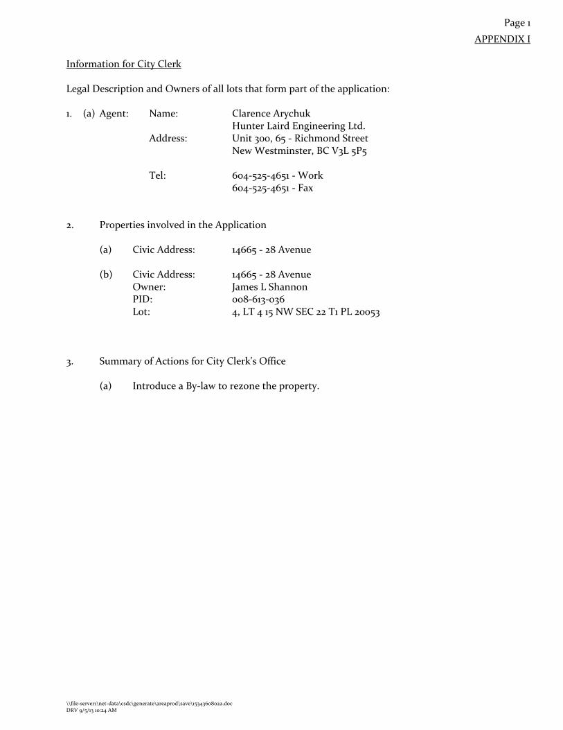
APPENDIX I
Information for City Clerk Legal Description and Owners of all lots that form part of the application: 1. (a) Agent: Name: Clarence Arychuk
Hunter Laird Engineering Ltd. Address: Unit 300, 65 - Richmond Street New Westminster, BC V3L 5P5 Tel: 604-525-4651 - Work 604-525-4651 - Fax
2. Properties involved in the Application
(a) Civic Address:
14665 - 28 Avenue
(b) Civic Address: 14665 - 28 Avenue Owner: James L Shannon PID: 008-613-036 Lot: 4, LT 4 15 NW SEC 22 T1 PL 20053
3. Summary of Actions for City Clerk's Office
(a) Introduce a By-law to rezone the property.

Page 2
\\file-server1\net-data\csdc\generate\areaprod\save\15343608022.doc DRV 9/5/13 10:24 AM
SUBDIVISION DATA SHEET
Proposed Zoning: RH and CD (based on RH-G)
Requires Project Data Proposed GROSS SITE AREA Acres 1.42 acres Hectares 0.5734 hectares NUMBER OF LOTS Existing 1 Proposed 3 SIZE OF LOTS Range of lot widths (metres) 28.7 m to 60.8 m Range of lot areas (square metres) 1624 m2 to 1858 m2 DENSITY Lots/Hectare & Lots/Acre (Gross) 5.23 uph / 2.11 upa Lots/Hectare & Lots/Acre (Net) 5.6 uph / 2.3 upa SITE COVERAGE (in % of gross site area) Maximum Coverage of Principal &
Accessory Building 25%
Estimated Road, Lane & Driveway Coverage 5% Total Site Coverage 30% PARKLAND Area (square metres) n/a % of Gross Site n/a Required PARKLAND 5% money in lieu NO TREE SURVEY/ASSESSMENT YES MODEL BUILDING SCHEME YES HERITAGE SITE Retention NO BOUNDARY HEALTH Approval NO DEV. VARIANCE PERMIT required Road Length/Standards NO Works and Services NO Building Retention NO Others NO

Pion BCP21692
h 6 7 8 9
10 /'":SRW Pion_ 8CP17664 69IJ34 ' "'J< 90'13'58"
~ ·~Y \ ,,.,. ~ 0
28A AVENUE ·<:l'~-7t9 5l :}__ ..'lQ:I.:i'str:. Ql.£aa Iii 90'13'58" 90'13'58" 0
50.385
I J'.ooo ~ ROAD 338.1 m2 ' 53.507
90'13'58" {u 39.411 32.683 28.771 90'13'58" 90'13'58"
1,1, ri ~
I (()
11 Sl .... (()
& - 4 G' I
~ .... co 00 ...
~~ 2 se co 1il 1
~~ <::> ·
~ ~ l8 0.162 ho ~ ~
~ ..0 0.186 ho u;;:t 1624.7 m2 Ill 1858.0 m2 "'m
~ :;r,
"' g:: 8\ Pion 20053 3 2 0> ... \ (/) ~,~ Plan 18943 Plan 18943 8\ "' ,.; :-~ 12 ~ 0> :S y;,.; ~ oCIO
~ '\~ ' <.o 0> ~ :lS
1 - 32.683 28.408 0
I 61.091 90'11'31"
I Pion 18943
<:: J2 3 N~ 13 a.: CIOn
~ ~ 0.186 ho ~~ lii g 1858.0 m2
I
N N ...
<1> ... {t '!_, 41.043 I J
60.897 90'11 '31" 1 103.923 ;so;._,~., 90'10'32" - "' . - ,o:891 -~oP.o -_; 90'11'31" :$9 ~. "'""' <1>1/l
"'"' <»g 57.4 m2 __ 1_64.89_4 - - tig -- - - -- - -
91'13'05" 290:646~ - - -- --5645
28th AVENUE
Preliminary Subdivision Layout Gil HunterLaird Amritpal Gill - #14665 28 Avenue ENG IN E ERIN G LT D .
June2013 7913-0093-00 116879

SURVEY PLAN TO ACCOMPANY CITY OF SURREY REZONING BYLAW NO. OF THE NORTH HALF LOT 4, SECTION 22, TOWNSHIP 1, NWD, PLAN 20053 City of Surrey B.C.G.S. 92G.006 0 10 20 30 40 50 m
~·.• ~ I 1-...-scALE - 1 : 750 All distances ore in metres 6 7 8
Plan _cSRW Pla_2 BCP1 7664 .
~ ~ (,7
1 I '* ·~
~ .,._
& co c:
~ 6: S:
g:: ~ (/)
11
0
28A AVENUE ~ ~
0 ~ 90' 13' 58" 0 l{) 32.683 ui
·-
tD 0 ~
28.806
BLOCK A 0.178 ha.
(1783 m2)
12 f'"\1 ,, __ , •• ,.
#o-"lrfr1 II II 1°"'\ "'' ...t::: ......... ({) ~ .........
II
c: 0
13 a:::
Legend: ha. Denotes hectares
CX) tD r<1 d r<1
N '<I" Ol d
I 1\JII 4.-VV\.~ ... ;
BLOCK B 0.395 ha .
(3953 m2)
60.891
90'11'31"
28th AVENUE
28.408 90'11'31"
; , \ \..,· .-~.·~
9 BCP21692
oob r;):-
• Ol No c.D' 0
'<I" Fo 0 ~ '<1: Ol ~ 0 r<1 0
3 Plan 18943
Cameron Land Surveying Ltd. B.C. Land Surveyors
\•I. ~ei'tifi~d correct to survey dated
Unit 206 - 16055 Fraser Highway Surrey, B.C. V4N OG2 Phone: 604-597-3777 Fax: 604-597-3783
)~r·~u • -:~hi[:~ ...
...• ·::; ~erineth W. Schuurman, B.C.L.S. This plan lies within the /:•,r;,,.;:,;,:·, ...
Greater Vancouver Regional District File: 4450-ZONING

TO:
SUYRREY INTER-OFFICE MEMO the future lives here.
Manager, Area Planning & Development - South Surrey Division Planning and Development Department
FROM: Development Services Manager, Engineering Department
DATE: August 28, 2013 PROJECT FILE:
RE: Engineering Requirements Location: 14665 28 Ave
REZONE/SUBDIVISION
Property and Right-of Way Requirements • Dedicate 0.942 metres on 28 Avenue for a total of 22.ooo metres; • Dedicate 5.500 metres on 28AAvenue for a total of17.ooo metres; • Provide 0.5 metre wide SROW along 28 Avenue and 28A Avenue
Works and Services • Construct and complete north side of 28 Avenue. • Construct 1.5 metre wide concrete sidewalk fronting the site on 28A Avenue. • Construct storm sewer main and sanitary sewer main on 28 Avenue. • Pay for One (1) Sanitary Connection Fee (SDR). • Restrictive covenant for pumped sanitary connection, if required. • Restrictive covenant on Lots 2 and 3 restricting U shaped driveway construction.
A Servicing Agreement is required prior to Rezone/Subdivision.
Remi Dube, P.Eng. Development Services Manager
HB
NOTE: Detailed Land Development Engineering Review available on file
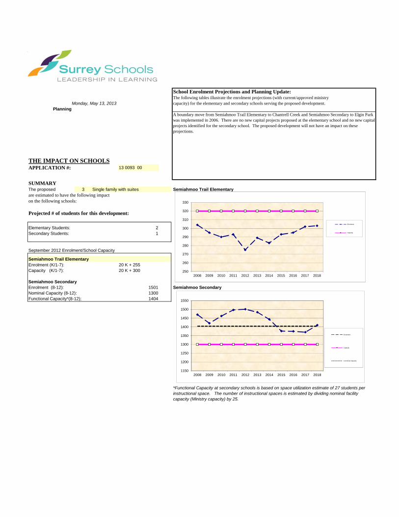
School Enrolment Projections and Planning Update:The following tables illustrate the enrolment projections (with current/approved ministrycapacity) for the elementary and secondary schools serving the proposed development.
THE IMPACT ON SCHOOLSAPPLICATION #: 13 0093 00
SUMMARY The proposed 3 Single family with suites Semiahmoo Trail Elementaryare estimated to have the following impacton the following schools:
Projected # of students for this development:
Elementary Students: 2Secondary Students: 1
September 2012 Enrolment/School Capacity
Semiahmoo Trail ElementaryEnrolment (K/1-7): 20 K + 255 Capacity (K/1-7): 20 K + 300
Semiahmoo SecondaryEnrolment (8-12): 1501 Semiahmoo SecondaryNominal Capacity (8-12): 1300 Functional Capacity*(8-12); 1404
Projected cumulative impact of development Nominal Capacity (8-12):subject project) in the subject catchment areas:
Elementary Students: 17Secondary Students: 164Total New Students: 181
A boundary move from Semiahmoo Trail Elementary to Chantrell Creek and Semiahmoo Secondary to Elgin Park was implemented in 2006. There are no new capital projects proposed at the elementary school and no new capital projects identified for the secondary school. The proposed development will not have an impact on these projections.
PlanningMonday, May 13, 2013
*Functional Capacity at secondary schools is based on space utilization estimate of 27 students per instructional space. The number of instructional spaces is estimated by dividing nominal facility capacity (Ministry capacity) by 25.
250
260
270
280
290
300
310
320
330
2008 2009 2010 2011 2012 2013 2014 2015 2016 2017 2018
Enrolment
Capacity
1150
1200
1250
1300
1350
1400
1450
1500
1550
2008 2009 2010 2011 2012 2013 2014 2015 2016 2017 2018
Enrolment
Capacity
Functional Capacity

BUILDING GUIDELINES SUMMARY Surrey Project no: 7913-0093-00 Project Location: 14665 - 28 Avenue, Surrey, B.C. Design Consultant: Tynan Consulting Ltd., (Michael E. Tynan) The draft Building Scheme proposed for this Project has been filed with the City Clerk. The following is a summary of the Residential Character Study and the Design Guidelines which highlight the important features and form the basis of the draft Building Scheme. 1. Residential Character 1.1 General Description of the Existing and/or Emerging Residential Character
of the Subject Site: This area was built out over a time period spanning from the 1970's to the 2000's. The age distribution from oldest to newest is: 1970's (33%), and post year 2000's (67%). A majority of homes in this area have a floor area exceeding 3550 sq.ft. Home size distribution is: 2501 - 3000 sq.ft. (11%), 3001 - 3550 sq.ft. (22%), and over 3550 sq.ft. (67%). Styles found in this area include: "Old Urban" (22%), "West Coast Modern" (11%), "Traditional" (33%), and "Neo-Traditional" (33%). Home types include: Basement Entry (11%), Cathedral Entry (11%), and Two-Storey (78%). Massing scale (front wall exposure) characteristics include: mid-scale massing with proportionally consistent, well balanced massing design (56%), mid to high scale massing (11%), mid-to-high scale massing with proportionally consistent, well balanced massing design (11%), and high scale, box-like massing (22%). The scale (height) range for front entrance structures include: one storey front entrance (44%), one storey front entrance veranda in heritage tradition (11%), and 1 ½ storey front entrance (44%). The range of roof slopes found in this area is: 5:12 (11%), 6:12 (22%), 12:12 (56%), and greater than 12:12 (11%). Main roof forms (largest upper floor truss spans) include: main common hip roof (78%), and main common gable roof (22%). Feature roof projection types include: Common Hip (9%), Common Gable (73%), and Dutch Hip (18%). Roof surfaces include: rectangular profile type asphalt shingles (11%), shake profile asphalt shingles (22%), concrete tile (rounded Spanish profile) (22%), and cedar shingles (44%). Main wall cladding materials include: horizontal vinyl siding (22%), Hardiplank siding (33%), and Stucco cladding (44%). Feature wall trim materials used on the front facade include: no feature veneer (8%), brick feature veneer (8%), stone feature veneer (46%), wood wall shingles accent (31%), and vertical cedar accent (8%). Wall cladding and trim colours include: Neutral (47%), Natural (53%). No primary derivative or "warm" colours have been used in this area. Covered parking configurations include: double garage (33%), and triple garage (67%). A variety of landscaping standards are evident, ranging from an old suburban landscape standard with sod and modest plantings to an extraordinary suburban-estate landscape

standard. Driveway surfaces include: asphalt (33%), exposed aggregate (44%), and stamped concrete (22%). 1.2 Prevailing Features of the Existing and Surrounding Dwellings
Significant to the Proposed Building Scheme:
1) Context Homes: The character of this area has been clearly defined by the new and aesthetically desirable housing stock. Two thirds of existing neighbouring homes provide suitable architectural context for use at the subject site. Ideal "context homes" include: 14611 - 28A Avenue, 14625 - 28A Avenue, 14635 - 28A Avenue, 14645 - 28A Avenue, 2838 - 146 Street, and 2818 - 146 Street. These homes meet new massing design standards in which various projections on the front of the home are proportionally consistent with one another, are well balanced across the façade, are visually pleasing, and are architecturally interesting. These new homes provide an appropriate standard for future development in this area, and emulating the standards found on these homes will reinforce the desirable emerging trend. Therefore, new homes should be consistent in theme, representation and character with homes identified above as context homes.
2) Style Character : New homes should have a suburban-estate character. Styles suited for this objective include “Traditional” (including English Country, English Tudor, English Manor, Cape Cod and other sub-styles that impart a formal, stately character), Classical Heritage, Neo-Heritage, and estate quality manifestations of the Neo-Traditional style. Note that style range is not restricted in the building scheme. However, the consultant refers to the character study style recommendations when reviewing plans for meeting style-character intent.
3) Home Types : There are a wide range of home types evident, and so some flexibility is justified. Home type (Two-Storey, Bungalow, Basement Entry, Split Level, etc..) will not be regulated in the building scheme.
4) Massing Designs : Massing designs should meet new standards for RH zoned subdivisions. New homes should exhibit "mid-scale" massing. Various elements and projections on the front of the home should be interesting architecturally, and should be in pleasing natural proportions to one another. These elements and proportions should be located so as to create balance across the façade.
5) Front Entrance Design : Front entrance porticos range from one to 1 ½ storeys in height. The recommendation however is to limit the range of entrance portico heights to between one storey and 1 ½ storeys to ensure there is not proportional overstatement of this one element.
6) Exterior Wall Cladding : This is an estate home area in which high value homes have been constructed with high quality cladding materials. Vinyl is a low cost utility cladding material that is well suited to areas where affordability is an objective. This is not the case here, as all lots and new homes will be of high value and estate quality. Vinyl therefore, is not recommended.
7) Roof surface : A wide range of roof surfacing materials have been used in this area including cedar shingles, concrete roof tiles, and asphalt shingles. The roof surface is not a uniquely recognizable characteristic of this area and so flexibility in roof surface materials is warranted. The recommendation is to permit cedar shingles, shake profile concrete roof tiles, shake profile asphalt shingles with a raised ridge cap, and new environmentally sustainable roof products that have a strong shake profile.
8) Roof Slope : Roof slopes of 8:12 or higher have been used on context homes. This is a suitable minimum roof slope given the objectives of ensuring continuity with context homes and to ensure that homes appear style-authentic within the proposed style range.

Streetscape: The area surrounding the subject site is in an advanced stage of transition from "old suburban" to an executive quality suburban estate area featuring architecturally significant 4000 sq.ft."Traditional" style Two-Storey homes situated on lots landscaped to a high suburban standard. The homes have mid-scale massing designs with mass allocations distributed in a proportionally correct and balanced manner across the façade. Main roof forms are common hip or common gable at slopes ranging from 8:12 to 16:12. There are a range of roof surface materials including cedar shakes, asphalt shingles and concrete roof tiles. Homes are clad in stucco, or Hardiplank, or vinyl (one vinyl home), and context homes have a significant stone feature. The colour range includes only natural and neutral hues. Landscaping meets a high modern suburban standard.
2. Proposed Design Guidelines 2.1 Specific Residential Character and Design Elements these Guidelines
Attempt to Preserve and/or Create: The new homes are constructed to a high architectural standard, meeting or exceeding standards
found in most executive-estate quality subdivisions in the City of Surrey. New homes are readily identifiable as one of the following styles: “Traditional” (including English Country, English Tudor, English Manor, Cape Cod and other sub-styles that impart a formal, stately character), Classical Heritage, Neo-Heritage, and estate quality manifestations of the Neo-Traditional style.
a new single family dwelling constructed on any lot meets year 2000's design standards, which include the proportionally correct allotment of mass between various street facing elements, the overall balanced distribution of mass within the front facade, readily recognizable style-authentic design, and a high trim and detailing standard used specifically to reinforce the style objectives stated above.
trim elements will include several of the following: furred out wood posts, articulated wood post bases, wood braces and brackets, louvered wood vents, bold wood window and door trim, highly detailed gable ends, wood dentil details, stone or brick feature accents, covered entrance verandas and other style-specific elements, all used to reinforce the style (i.e. not just decorative).
the development is internally consistent in theme, representation, and character. the entrance element will be limited in height (relative dominance) to 1 to 1 ½ storeys. 2.2 Proposed Design Solutions:
Interfacing Treatment Strong relationship with neighbouring “context homes” with existing dwellings) including 14611 - 28A Avenue, 14625 - 28A Avenue, 14635 -
28A Avenue, 14645 - 28A Avenue, 2838 - 146 Street, and 2818 - 146 Street. Homes will therefore be in a compatible style range, including “Traditional” (including English Country estate, English Tudor, English Manor, Cape Cod and other sub-styles that impart a formal, stately character), Classical Heritage, Neo-Heritage, and estate quality manifestations of the Neo-Traditional style (note however that style range is not specifically regulated in the building scheme). New homes will have similar or better massing designs (equal or lesser massing scale, consistent proportionality between various elements, and balance of volume across the façade). New homes will have

similar roof types, roof slope and roofing materials. Wall cladding, feature veneers and trim treatments will meet or exceed standards found on the aforesaid context homes.
Exterior Materials/Colours: Stucco, Cedar, Hardiplank, Brick, and Stone. Vinyl siding not permitted on exterior walls.
“Natural” colours such as browns, greens, clays, and other earth-tones, and “Neutral” colours such as grey, white, and cream are permitted. Primary colours are not recommended for this development. “Warm” colours such as pink, rose, peach, salmon are not permitted. Trim colours: Shade variation of main colour, complementary, neutral, or subdued contrast only.
Roof Pitch: Minimum 8:12. Roof Materials/Colours: Cedar shingles, shake profile concrete roof tiles, shake profile
asphalt shingles with a raised ridge cap, and new environmentally sustainable roofing products providing that aesthetic properties of the new materials are equal to or better than that of the traditional roofing products. Greys, black, or browns only.
In-ground basements: Permitted, subject to determination that service invert locations
are sufficiently below grade. Basements will appear underground from the front.
Treatment of Corner Lots: Not applicable - there are no corner lots Landscaping: High modern suburban standard: Tree planting as specified on
Tree Replacement Plan plus minimum 50 shrubs of a minimum 3 gallon pot size. Sod from street to face of home. Driveways: exposed aggregate, interlocking masonry pavers, or stamped concrete.
Compliance Deposit: $5,000.00 Summary prepared and submitted by: Tynan Consulting Ltd. Date: July 16, 2013
Reviewed and Approved by: Date: July 16, 2013

Arborist Report − 14665 28 Ave, Surrey
14
TREE PRESERVATION SUMMARY
Project Location: 14665 28 Ave Surrey, BC
Registered Arborist: Lesley Gifford, B.App Sc.ISA Certified Arborist (PN5432A)Certified Tree Risk Assessor (56)BC Parks Wildlife and Danger Tree Assessor
Detailed Assessment of the existing trees of an Arborist’s Report is submitted on file. The following is asummary of the tree assessment report for quick reference.
1.General Tree Assessment of the Subject Site: Almost two acre parcel with two apartment buildings uponit.
2.Summary of Proposed Tree Removal and Placement:
The summary will be available before final adoption.
Number of Protected Trees Identified (including city) 46 (A)
Number of Protected Trees declared high risk due to natural causes 0 (B)
Number of Protected Trees to be removed 19 (C)
Number of Protected Trees to be Retained ( A-B-C ) 21 (D)
Number of Replacement Trees Required ( xx @ 1:1 plus xx @2:1) 43 (E)
Number of Replacement Trees Proposed 4 (F)
Number of Replacement Trees in Deficit ( E-F ) 39 (G)
Total Number of Protected and Replacement Trees on Site ( D+F ) 25 (H)
Number of Lots Proposed in the Project 3 (I )
Average Number of Trees per Lot ( H / I ) 83
3.Tree Survey and Preservation / Replacement Plan
Tree Survey and Preservation / Replacement Plan is attached
This plan will be available before final adoption
Summary prepared andsubmitted by:
Sep. 3, 2013
Arborist Date
- 1 -
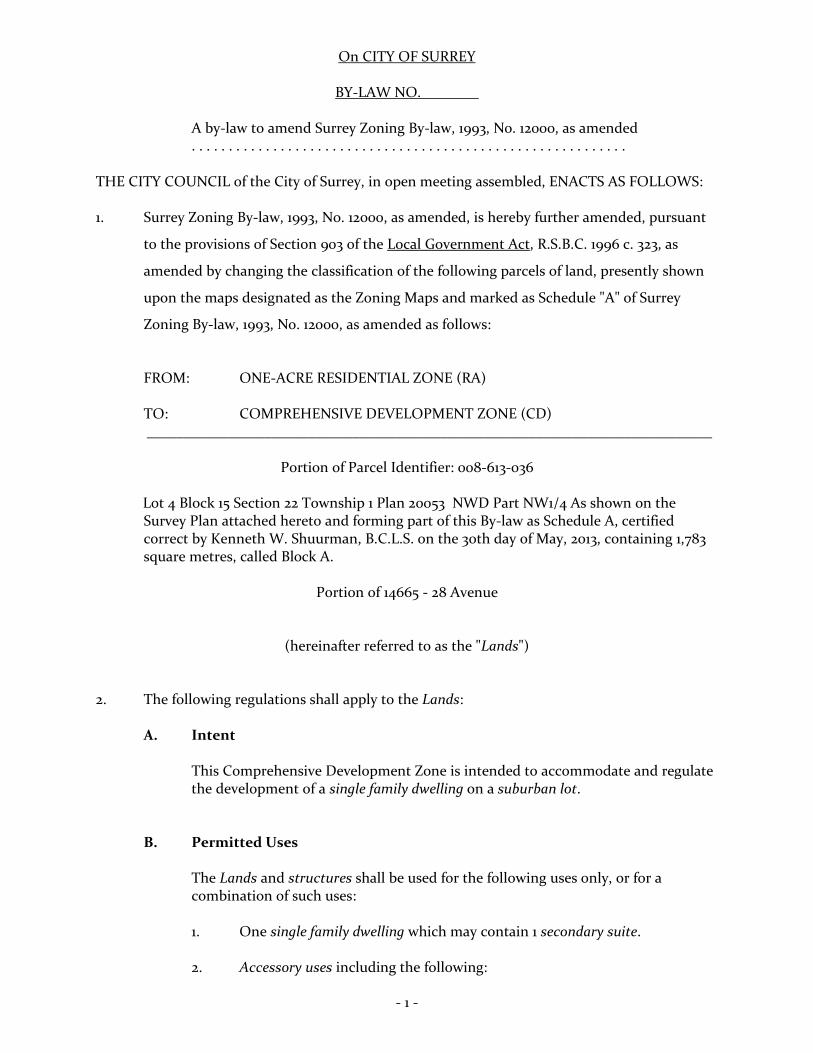
On CITY OF SURREY
BY-LAW NO.
A by-law to amend Surrey Zoning By-law, 1993, No. 12000, as amended . . . . . . . . . . . . . . . . . . . . . . . . . . . . . . . . . . . . . . . . . . . . . . . . . . . . . . . . . . . THE CITY COUNCIL of the City of Surrey, in open meeting assembled, ENACTS AS FOLLOWS: 1. Surrey Zoning By-law, 1993, No. 12000, as amended, is hereby further amended, pursuant
to the provisions of Section 903 of the Local Government Act, R.S.B.C. 1996 c. 323, as
amended by changing the classification of the following parcels of land, presently shown
upon the maps designated as the Zoning Maps and marked as Schedule "A" of Surrey
Zoning By-law, 1993, No. 12000, as amended as follows:
FROM: ONE-ACRE RESIDENTIAL ZONE (RA) TO: COMPREHENSIVE DEVELOPMENT ZONE (CD) _____________________________________________________________________________
Portion of Parcel Identifier: 008-613-036
Lot 4 Block 15 Section 22 Township 1 Plan 20053 NWD Part NW1/4 As shown on the Survey Plan attached hereto and forming part of this By-law as Schedule A, certified correct by Kenneth W. Shuurman, B.C.L.S. on the 30th day of May, 2013, containing 1,783 square metres, called Block A.
Portion of 14665 - 28 Avenue
(hereinafter referred to as the "Lands") 2. The following regulations shall apply to the Lands:
A. Intent This Comprehensive Development Zone is intended to accommodate and regulate the development of a single family dwelling on a suburban lot.
B. Permitted Uses
The Lands and structures shall be used for the following uses only, or for a combination of such uses: 1. One single family dwelling which may contain 1 secondary suite. 2. Accessory uses including the following:

- 2 -
(a) Bed and breakfast use in accordance with Section B.2, Part 4
General Provisions of Surrey Zoning By-law, 1993, No. 12000, as amended; and
(b) The keeping of boarders or lodgers in accordance with Section B.2,
Part 4 General Provisions of Surrey Zoning By-law, 1993, No. 12000, as amended.
C. Lot Area
Not applicable to this Zone. D. Density
1. For the purpose of subdivision, the maximum density shall not exceed 5 dwelling units per hectare [2.0 u.p.a.].
2. (a) For the purpose of this Section and notwithstanding the definition
of floor area ratio in Part 1 Definitions of Surrey Zoning By-law, 1993, No. 12000, as amended, all covered areas used for parking shall be included in the calculation of floor area ratio unless the covered parking is located within the basement; and
(b) For building construction within a lot the floor area ratio shall not
exceed 0.32, provided that, of the resulting allowable floor area, 45 square metres [480 sq.ft.] shall be reserved for use only as a garage or carport and 10 square metres [105 sq.ft.] shall be reserved for use only as accessory buildings and structures.
E. Lot Coverage
The lot coverage shall not exceed 25%.
F. Yards and Setbacks
Buildings and structures shall be sited in accordance with the following minimum setbacks:

- 3 -
Use
Setback Front Yard Rear Yard Side Yard
Principal 7.5 m. 7.5 m. 3.0 m. Building [25 ft.] [25 ft.] [10 ft.] Accessory Buildings and Structures Greater Than 10 square metres
18.0 m. [60 ft.]
1.8 m [6 ft.]
1.0 m [3 ft.]
Other Accessory Buildings and Structures 18.0 m
[60 ft.] 0.0 m 0.0 m.
Measurements to be determined as per Part 1 Definitions of Surrey Zoning By-law, 1993, No. 12000, as amended. G. Height of Buildings Measurements to be determined as per Part 1 Definitions of Surrey Zoning By-law,
1993, No. 12000, as amended. 1. Principal building: The building height shall not exceed 9 metres [30 ft.]. 2. Accessory buildings and structures: The building height shall not exceed
4 metres [13 feet] except that where the roof slope and construction materials of an accessory building are the same as that of the principal building, the building height of the accessory building may be increased to 5 metres [16.5 ft.].
H. Off-Street Parking
1. Resident and visitor parking spaces shall be provided as stated in Table C.6
of Part 5 Off-Street Parking and Loading/Unloading of Surrey Zoning By-law, 1993, No. 12000, as amended.
2. Outside parking or storage of campers, boats and vehicles including cars,
trucks and house trailers ancillary to the residential use, shall be limited to:
(a) A maximum of 2 cars or trucks; (b) House trailer, camper or boat provided that the combined total
shall not exceed 1; and (c) The total amount permitted under (a) and (b) shall not exceed 3.
- 4 -
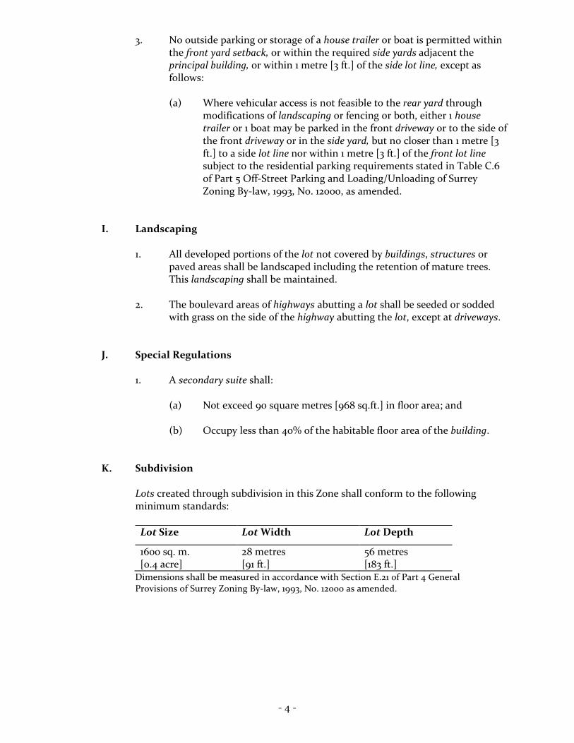
3. No outside parking or storage of a house trailer or boat is permitted within the front yard setback, or within the required side yards adjacent the principal building, or within 1 metre [3 ft.] of the side lot line, except as follows:
(a) Where vehicular access is not feasible to the rear yard through
modifications of landscaping or fencing or both, either 1 house trailer or 1 boat may be parked in the front driveway or to the side of the front driveway or in the side yard, but no closer than 1 metre [3 ft.] to a side lot line nor within 1 metre [3 ft.] of the front lot line subject to the residential parking requirements stated in Table C.6 of Part 5 Off-Street Parking and Loading/Unloading of Surrey Zoning By-law, 1993, No. 12000, as amended.
I. Landscaping
1. All developed portions of the lot not covered by buildings, structures or paved areas shall be landscaped including the retention of mature trees. This landscaping shall be maintained.
2. The boulevard areas of highways abutting a lot shall be seeded or sodded
with grass on the side of the highway abutting the lot, except at driveways. J. Special Regulations
1. A secondary suite shall:
(a) Not exceed 90 square metres [968 sq.ft.] in floor area; and (b) Occupy less than 40% of the habitable floor area of the building.
K. Subdivision
Lots created through subdivision in this Zone shall conform to the following minimum standards:
Lot Size Lot Width Lot Depth
1600 sq. m. [0.4 acre]
28 metres [91 ft.]
56 metres [183 ft.]
Dimensions shall be measured in accordance with Section E.21 of Part 4 General Provisions of Surrey Zoning By-law, 1993, No. 12000 as amended.
- 5 -
L. Other Regulations In addition to all statutes, by-laws, orders, regulations or agreements, the
following are applicable, however, in the event that there is a conflict with the provisions in this Comprehensive Development Zone and other provisions in Surrey Zoning By-law, 1993, No. 12000, as amended, the provisions in this Comprehensive Development Zone shall take precedence:
1. Definitions are as set out in Part 1 Definitions, of Surrey Zoning By-law,
1993, No. 12000, as amended. 2. Prior to any use, the Lands must be serviced as set out in Part 2 Uses
Limited, of Surrey Zoning By-law, 1993, No. 12000, as amended and in accordance with the servicing requirements for the RH-G Zone as set forth in the Surrey Subdivision and Development By-law, 1986, No. 8830, as amended.
3. General provisions are as set out in Part 4 General Provisions of Surrey
Zoning By-law, 1993, No. 12000, as amended. 4. Additional off-street parking requirements are as set out in Part 5
Off-Street Parking and Loading/Unloading of Surrey Zoning By-law, 1993, No. 12000, as amended.
5. Sign regulations are as set out in Surrey Sign By-law, 1999, No. 13656, as
amended. 6. Special building setbacks are as set out in Part 7 Special Building Setbacks,
of Surrey Zoning By-law, 1993, No. 12000, as amended. 7. Building permits shall be subject to the Surrey Building By-law, 2012, No.
17850, as amended. 8. Subdivisions shall be subject to the applicable Surrey Development Cost
Charge By-law, 2013, No. 17856, as may be amended or replaced from time to time, and the development cost charges shall be based on the RH-G Zone.
9. Tree regulations are set out in Surrey Tree Protection By-law, 2006, No.
16100, as amended.

- 6 -
3. This By-law shall be cited for all purposes as "Surrey Zoning By-law, 1993, No. 12000, Amendment By-law, , No. ."
READ A FIRST AND SECOND TIME on the th day of , 20 . PUBLIC HEARING HELD thereon on the th day of , 20 . READ A THIRD TIME ON THE th day of , 20 . RECONSIDERED AND FINALLY ADOPTED, signed by the Mayor and Clerk, and sealed with the Corporate Seal on the th day of , 20 . ______________________________________ MAYOR ______________________________________ CLERK \\file-server1\net-data\csdc\generate\areaprod\save\20351098067.doc LFM 9/4/13 10:21 AM

SURVEY PLAN TO ACCOMPANY CITY OF SURREY REZONING BYLAW NO. OF THE NORTH HALF LOT 4, SECTION 22, TOWNSHIP 1, NWD, PLAN 20053 City of Surrey B.C.G.S. 92G.006 0 10 20 30 40 50 m
~·.• ~ I 1-...-scALE - 1 : 750 All distances ore in metres 6 7 8
Plan _cSRW Pla_2 BCP1 7664 .
~ ~ (,7
1 I '* ·~
~ .,._
& co c:
~ 6: S:
g:: ~ (/)
11
0
28A AVENUE ~ ~
0 ~ 90' 13' 58" 0 l{) 32.683 ui
·-
tD 0 ~
28.806
BLOCK A 0.178 ha.
(1783 m2)
12 f'"\1 ,, __ , •• ,.
#o-"lrfr1 II II 1°"'\ "'' ...t::: ......... ({) ~ .........
II
c: 0
13 a:::
Legend: ha. Denotes hectares
CX) tD r<1 d r<1
N '<I" Ol d
I 1\JII 4.-VV\.~ ... ;
BLOCK B 0.395 ha .
(3953 m2)
60.891
90'11'31"
28th AVENUE
28.408 90'11'31"
; , \ \..,· .-~.·~
9 BCP21692
oob r;):-
• Ol No c.D' 0
'<I" Fo 0 ~ '<1: Ol ~ 0 r<1 0
3 Plan 18943
Cameron Land Surveying Ltd. B.C. Land Surveyors
\•I. ~ei'tifi~d correct to survey dated
Unit 206 - 16055 Fraser Highway Surrey, B.C. V4N OG2 Phone: 604-597-3777 Fax: 604-597-3783
)~r·~u • -:~hi[:~ ...
...• ·::; ~erineth W. Schuurman, B.C.L.S. This plan lies within the /:•,r;,,.;:,;,:·, ...
Greater Vancouver Regional District File: 4450-ZONING