richard ghail thomas widemann colin wilson · 30th november 2016 ‐‐vexag 14 slide 2© rich...
TRANSCRIPT

30th November 2016 ‐‐ VEXAG 14 © Rich Ghail EnVision: European Plans for Venus
Richard GhailLead Proposer
Thomas WidemannProgramme Management Lead
Colin WilsonScience Investigation Lead
30th November 2016 ‐‐ VEXAG 14 Slide 2 © Rich Ghail EnVision: European Plans for Venus
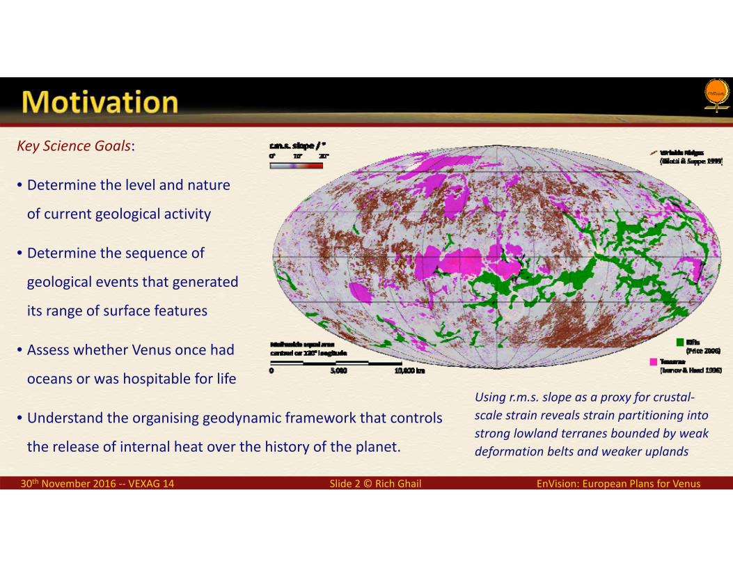
Key Science Goals:
• Determine the level and nature
of current geological activity
• Determine the sequence of
geological events that generated
its range of surface features
• Assess whether Venus once had
oceans or was hospitable for life
• Understand the organising geodynamic framework that controls
the release of internal heat over the history of the planet.
Using r.m.s. slope as a proxy for crustal‐scale strain reveals strain partitioning into strong lowland terranes bounded by weak deformation belts and weaker uplands

30th November 2016 ‐‐ VEXAG 14 Slide 3 © Rich Ghail EnVision: European Plans for Venus
Key Science Goals:
• Determine the level and nature
of current geological activity
• Determine the sequence of
geological events that generated
its range of surface features
• Assess whether Venus once had
oceans or was hospitable for life
• Understand the organising geodynamic framework that controls
the release of internal heat over the history of the planet.
Using r.m.s. slope as a proxy for crustal‐scale strain reveals strain partitioning into strong lowland terranes bounded by weak deformation belts and weaker uplands

30th November 2016 ‐‐ VEXAG 14 Slide 4 © Rich Ghail EnVision: European Plans for Venus
Key Science Goals:
• Determine the level and nature
of current geological activity
• Determine the sequence of
geological events that generated
its range of surface features
• Assess whether Venus once had
oceans or was hospitable for life
• Understand the organising geodynamic framework that controls
the release of internal heat over the history of the planet.
Using r.m.s. slope as a proxy for crustal‐scale strain reveals strain partitioning into strong lowland terranes bounded by weak deformation belts and weaker uplands

30th November 2016 ‐‐ VEXAG 14 Slide 5 © Rich Ghail EnVision: European Plans for Venus
Key Science Goals:
• Determine the level and nature
of current geological activity
• Determine the sequence of
geological events that generated
its range of surface features
• Assess whether Venus once had
oceans or was hospitable for life
• Understand the organising geodynamic framework that controls
the release of internal heat over the history of the planet.
We are more used to thinking about rifts and other structural features than the terranes bounded by them. Note the distributed low‐level interior strain

30th November 2016 ‐‐ VEXAG 14 Slide 6 © Rich Ghail EnVision: European Plans for Venus
Key Science Goals:
• Determine the level and nature
of current geological activity
• Determine the sequence of
geological events that generated
its range of surface features
• Assess whether Venus once had
oceans or was hospitable for life
• Understand the organising geodynamic framework that controls
the release of internal heat over the history of the planet.
Global Zonal Reconnaissance Exploration Locality
Coverage >95% >95% >20% >2% >0∙2%
Unit Area Global 2500 × 2500 km 1500 × 1500 km 100 × 100 km 5 × 5 km
Resolution 50 km 150 m 30 m 6 m 1 m
Feature Size 150 km 500 m 100 m 20 m <4 m
Geomorphological Features
Structures Terra ‘continents’, Planitia Chasmata, Dorsa Folds, graben Fault scarps
Volcanoes Volcanic rises (Regio) Volcanic edifices Lava Flows Flow textures
Sediments ‘Featureless’ plains Parabolas, halos Landslides Dunes

30th November 2016 ‐‐ VEXAG 14 Slide 7 © Rich Ghail EnVision: European Plans for Venus
Key Science Goals:
• Determine the level and nature
of current geological activity
• Determine the sequence of
geological events that generated
its range of surface features
• Assess whether Venus once had
oceans or was hospitable for life
• Understand the organising geodynamic framework that controls
the release of internal heat over the history of the planet.
Goal Measurement Resolution Instrument
Surface change < ±1 cm a⁻¹ at 10–50 m spatial VenSAR‐I
Geomorphology Images at 10–50 m spatial VenSAR‐P
Topography at 10–50 m vertical, 100–500 m spatial VenSAR‐P
Specified targets Images at 1–10 m spatial VenSAR‐H / VenSAR‐S
Subsurface structure Profiles at 10–50 m vertical and 100–500 m spatial SRS
Thermal emissivity Signal to noise >100 at <50 km spatial VEM‐M, VenSAR‐R
SO₂ concentration < ±1% at <300 km spatial and 30–40 km altitude VEM‐H / VEM‐U
H₂O concentration < ±10% at <300 km spatial and <15 altitude VEM‐H / VEM‐U
D/H ratio < ±10% at <300 km spatial and <15 altitude VEM‐H
Gravity field Spherical harmonic degree and order 120 Tracking
Spin Rate < ±10⁻⁸ (1 minute in one Venus day) VenSAR‐S + Tracking
Spin Axis < ±0∙001° in right ascension and declination VenSAR‐I

30th November 2016 ‐‐ VEXAG 14 Slide 8 © Rich Ghail EnVision: European Plans for Venus
Shrouded in permanent clouds, the 90 bar, 750 K Venus atmosphere is prohibitive for surface rovers and opaque at wavelengths shorter than ~3∙5 cm.
In other respects the atmosphere is benign:• The total electron count is <1 TeV• IR brightness temperature ~50 K cooler than Earth• Drag‐free orbits above 220 km altitude
EnVision’s InSAR coherence requirement drives our choice for an S‐band radar.

30th November 2016 ‐‐ VEXAG 14 Slide 9 © Rich Ghail EnVision: European Plans for Venus
NovaSAR will consist offour small low‐cost SARsatellites providing globalcontinuous environmentalmanagement anddisaster monitoring. Thefirst is being fundedby the UK governmentfor launch in early 2017.
VenSAR is undergoingdesign work to hardenagainst thermal andionising radiation duringinterplanetary cruise and at Venus.
During operations, the extreme thermal range during the short orbit effectively limits the operating time to about 15 minutes per orbit.

30th November 2016 ‐‐ VEXAG 14 Slide 10 © Rich Ghail EnVision: European Plans for Venus
Resolution Looks Tx Incidence Sensitivity Swath Duration Data
VI1 InSAR 27 m 18 4% 21° – 31° −21∙8 dB 53 km 498 s 66 Mbps
VI2 InSAR 27 m 18 4% 19° – 29° −20∙9 dB 53 km 498 s 68 Mbps
VI3 InSAR 27 m 18 4% −21° – −31° −21∙8 dB 53 km 498 s 66 Mbps
VP1 StereoPolSAR 30 m 9 4% 37° – 41° −16∙9 dB 53 km 873 s 127 Mbps
VH1 HiRes 6 m 6 20% 38° – 43° −20∙1 dB 22 km 291 s 353 Mbps
VH2 HiRes 6 m 6 20% 38° – 43° −20∙1 dB 32 km 291 s 513 Mbps
VS1 Spotlight 1 m 1 20% 38° – 39° −21∙5 dB 5 km 4 s 468 Mbps
VR1 Radiometry 5 × 30 km n/a 0% −4° – +4° ~1 K 38 km <2760 s <0∙25 kbps
Level 1 dataSingle‐look complex images (SLC)Multi‐look map oriented images (GRD)Radiometry profilesInitial ephemeris dataLevel 2 dataInterim geocoded image mosaicsOrbit‐orbit interferogramsRevised ephemeris dataLevel 3 dataGround surface change / deformation mapsGeocoded & orthorectified image mosaicsDigital Elevation Models (gridded at 60 m)

30th November 2016 ‐‐ VEXAG 14 Slide 11 © Rich Ghail EnVision: European Plans for Venus
Simulated Magellan110 m resolution SARimage of Holuhraun,Iceland (derived fromSentinel 1a data). Noticethe low contrast from2‐bit BAQ compressionand foreshortening due to lack of appropriate DEM.
Simulated 30 m resolution HHVHVV StereoPolSARimage (derived from Sentinel 1a data). Note the new lava flow in blue at lower left.Scale bar in all images is 2 km.

30th November 2016 ‐‐ VEXAG 14 Slide 12 © Rich Ghail EnVision: European Plans for Venus
Simulated Magellan110 m resolution SARimage of Holuhraun,Iceland (derived fromSentinel 1a data). Noticethe low contrast from2‐bit BAQ compressionand foreshortening due to lack of appropriate DEM.
Simulated 30 m resolution HHVHVV StereoPolSARimage (derived from Sentinel 1a data). Note the new lava flow in blue at lower left.Scale bar in all images is 2 km.
Simulated 6 m resolution HiRes image (derived from TerraSAR‐X data).

30th November 2016 ‐‐ VEXAG 14 Slide 13 © Rich Ghail EnVision: European Plans for Venus
Simulated Magellan110 m resolution SARimage of Holuhraun,Iceland (derived fromSentinel 1a data). Noticethe low contrast from2‐bit BAQ compressionand foreshortening due to lack of appropriate DEM.
Simulated 30 m resolution HHVHVV StereoPolSARimage (derived from Sentinel 1a data). Note the new lava flow in blue at lower left.Scale bar in all images is 2 km.
Simulated 6 m resolution HiRes image (derived from TerraSAR‐X data).
NovaSAR 6 m airborne test data, Pembroke Dock

30th November 2016 ‐‐ VEXAG 14 Slide 14 © Rich Ghail EnVision: European Plans for Venus
The Radar Sounder for EnVision can acquire information on the shallow subsurface with the following main scientific goals:• Characterisation of the different stratigraphic and structural
patterns of the subsurface.• Study the volcanism phenomena and their impact on the
geological evolution of the Venusian topography.• Detection of subsurface structures non directly linked with
surface.• Analysis of the materials in the surface and subsurface and
their metamorphism linked to the burial process.• Synergistic analysis of the data provided by SAR and radar
sounder sensors to study the evolution of the planet.• Analysis of the total electron content of the
ionosphere.One of the main issues for the design of theradar sounder instrument for EnVision concernsthe physical and electromagnetic modelling ofthe surface and subsurface targets.
Transmitted central frequency (fc) In the range 6 ‐ 30 MHz
Transmitted bandwidth (Bw) In the range 2 ‐ 10 MHz
Antenna type Dipole (deployable)
Antenna dimension TBD (depending on the central frequency)
Power 30 W
Along track resolution < 1 km
Across track resolution < 5 km
Vertical resolution 75 m (Bw=2 MHz) ‐ 15 m (Bw=10 MHz) (vacuum)
Estimated maximum penetration depth 1.5 Km (fc=6 MHz) ‐ 600 m (fc=30 MHz)
Data rate 300 – 10000 kbps (depending on selected parameters and operation scenarios)
Mass (without antenna) 10 kg
Size 37×25×13 cm
Pointing requirements Nadir
SHARAD radargram over a portion of western Medusae Fossae Formation, a low‐density pyroclastic deposit spanning across the crustal dichotomy of Mars. The deposit labelled "North Hill“ (nh) is about 500 m thick (taken from [6]).

30th November 2016 ‐‐ VEXAG 14 Slide 15 © Rich Ghail EnVision: European Plans for Venus
The Radar Sounder for EnVision can acquire information on the shallow subsurface with the following main scientific goals:• Characterization of the different stratigraphic and structural
patterns of the subsurface.• Study the volcanism phenomena and their impact on the
geological evolution of the Venusian topography.• Detection of subsurface structures non directly linked with
surface.• Analysis of the materials in the surface and subsurface and
their metamorphism linked to the burial process.• Synergistic analysis of the data provided by SAR and radar
sounder sensors to study the evolution of the planet.• Analysis of the total electron content of the
ionosphere.One of the main issues for the design of theradar sounder instrument for EnVision concernsthe physical and electromagnetic modelling ofthe surface and subsurface targets.
SHARAD radargram over a portion of western Medusae Fossae Formation, a low‐density pyroclastic deposit spanning across the crustal dichotomy of Mars. The deposit labelled "North Hill“ (nh) is about 500 m thick (taken from [6]).

30th November 2016 ‐‐ VEXAG 14 Slide 16 © Rich Ghail EnVision: European Plans for Venus
VIRTIS has mapped the hot surface at 1 μm using emissivity data[Helbert, Müller, et al. 2008& Müller, Helbert et al. 2009, 2010]
Key Parameter ValueInstrument Concept Pushbroom design
FOV / swath 60° / 250 km
Detector SOFRADIR “Neptune” 500 X 256 HgCdTe array
Cooled focal plane 150 K, pulse‐tube cooler
14 spectral bands Bandwidth < 10 nm Variation < 1nm
Processed Data Rate 190 kb/s (1 Mb/orbit)
Mass / Power (CBE) ~5.4 kg / ~18.5 W
Volume 30 cm x 30 cm x 40 cm
VEM‐M spectral bands and science themes

30th November 2016 ‐‐ VEXAG 14 Slide 17 © Rich Ghail EnVision: European Plans for Venus
E. Marcq et al. (Venus Express); L. Esposito et al. (earlier data); image ESA/AOES Medialab
Left: the optical assembly, which is inverted and mounted on a baseplate on the underside of the radiator.Right: the SOFRADIR detector for NOMAD on ExoMars.
VEM‐H is a spectrometer probing the near‐infrared nightside windows with very high spectral resolution (resolving power ~ 40,000). It will:• Quantify SO₂, H₂O and HDO in the lower atmosphere• Characterise of volcanic plumes• Detect other sources of gas exchange with the surface• Complement VenSAR and VEM‐M surface observations
VEM‐U is a small, light, UV spectrometer which will map mesospheric SO₂ abundances on the dayside of Venus. Together with VEM‐M and VEM‐H it will link surface, tropospheric and mesospheric changes in SO₂, H₂O and other gases.

30th November 2016 ‐‐ VEXAG 14 Slide 18 © Rich Ghail EnVision: European Plans for Venus
Venus apparently rotated more quickly during the period of the Magellan mission (small red error bars, 1990‐1992) than it did in the first Earth‐based observations (green) or in later measurements from Earth and by Venus Express (blue). Vertical bars indicate measurement uncertainty, horizontal bars the period over which the measurement was made.
Preliminary simulations indicate that an accuracy of ~±0∙002 in k₂ is achievable by stacking together 3 years of navigation tracking data of EnVision spacecraft, more than sufficient to distinguish between different models of internal structure.

30th November 2016 ‐‐ VEXAG 14 Slide 19 © Rich Ghail EnVision: European Plans for Venus
EnVision is a 2m cubic platform with a dry mass of 950 kg.Planned for launch from an Ariane 6.2 in October 2029,200 days aerobraking are anticipated to achieve the259 km altitude circular polar orbit.
The following operating modes are planned during each24‐hour period:
Communications mode: 5½ hour HGA Earth‐pointed,solar array oriented towards the Sun, one‐axis degreeof freedom;
VenSAR mode: <15 minutes, inertial 3‐axes pointed,nadir face facing Venus centre, rolled by up to ±35°around the spacecraft velocity vector (x‐axis); and
Night side science mode: 45 minute nadir face facingVenus centre, inertial 3‐axes pointed.
Telemetry is provided by a fixed 3‐m, 65 W RF, Ka‐bandhigh gain antenna. With GMSK (0∙5) modulation and 1/4Turbo codes, a minimum link rate of 4 Mbps is achieved.
Platform could support a secondary Cubesat payload

30th November 2016 ‐‐ VEXAG 14 Slide 20 © Rich Ghail EnVision: European Plans for Venus
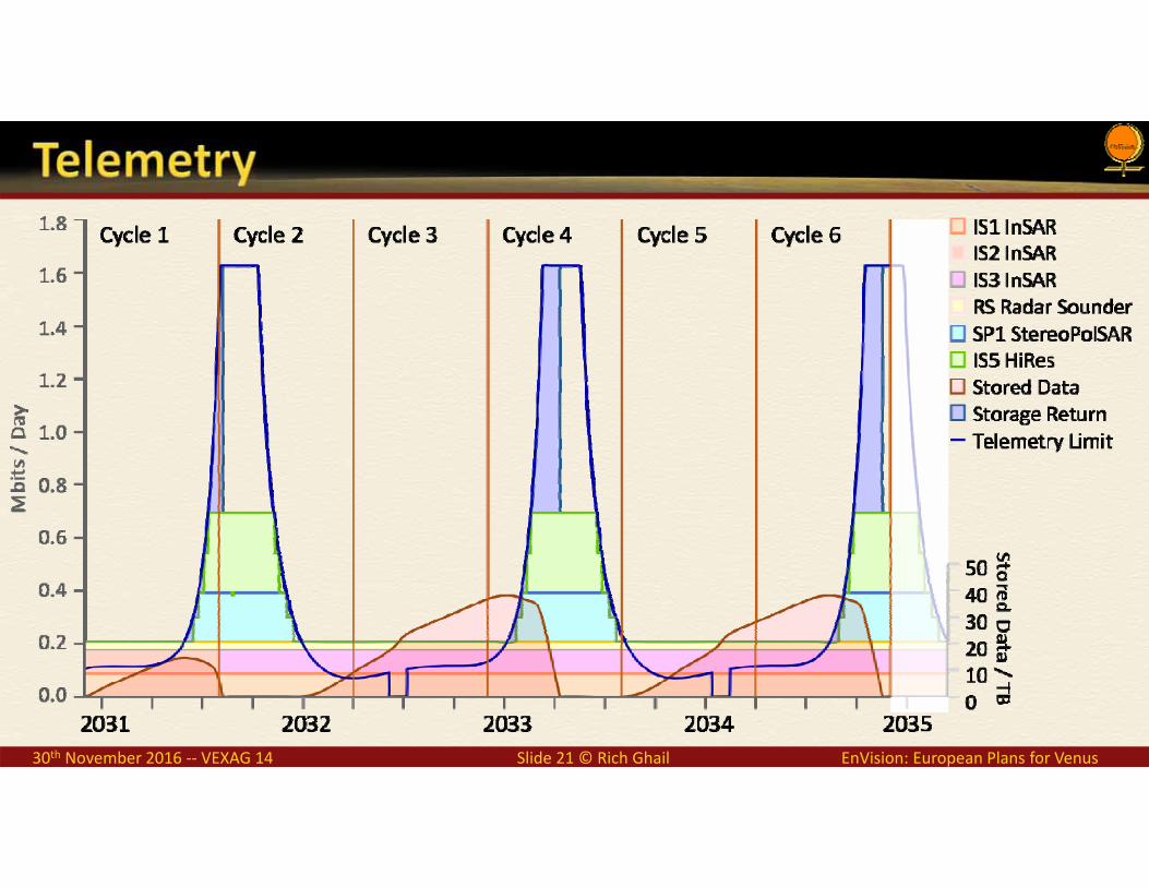
30th November 2016 ‐‐ VEXAG 14 Slide 21 © Rich Ghail EnVision: European Plans for Venus

30th November 2016 ‐‐ VEXAG 14 Slide 22 © Rich Ghail EnVision: European Plans for Venus
We have a very poor understanding of Venus, particularly its surface materials
High resolution imagery, topography and compositional data are needed to understand
D‐InSAR change detection will determine the location and nature of geological activity on Venus today
Surface, tropospheric and mesospheric volatile measurements will characterise geochemical cycles
Calibrated polarimetric and high resolution contextual imagery of the Venera landing sites is needed to understand what the landers imaged
EnVision will take our knowledge of Venus towards that of Mars today
Venera 13 landing site[Don P. Mitchell]