ridgetop spreading features and relationship to...
TRANSCRIPT

RIDGETOP SPREADING FEATURES AND RELATIONSHIP TO EARTHQUAKES, SAN GABRIEL MOUNTAINS REGION, SOUTHERN CALIFORNIA -- PART A: DISTRIBUTION AND DESCRIPTION OF RIDGETOP
DEPRESSIONS (SACKUNGEN)
by James P. McCalpin and Earl W. Hart
2002
(Previously released as the following report, but with minor changes and corrections plus the inclusion of 25 detailed maps of quadrangles)
RIDGETOP SPLITTING, SPREADING, AND SHATTERING RELATED TO EARTHQUAKES IN SOUTHERN CALIFORNIA
Final Technical Report Contract 1434-HQ-GR-1026
National Earthquake Hazards Reduction Program U.S. Geological Survey
Principal Investigator: James P. McCalpin
GEO-HAZ Consulting, Inc. P.O. Box 837
600 East Galena Ave Crestone, CO 81131
OFFICE: 719-256-5227 FAX: 719-256-5228
Co-PI
Earl Hart 6 Vista Court
Corte Madera, CA 94925 (415) 924-0325
April 23, 1999 This report was prepared under contract to the U.S. Geological Survey and has not been reviewed for conformity with USGS editorial standards and stratigraphic nomenclature. Opinions and conclusions expressed herein do not necessarily represent those of the USGS or the California Geological Survey. Any use of trade names is for descriptive purposes only and does not imply endorsement by the USGS
or CGS.

2
NON-TECHNICAL SUMMARY The San Gabriel and eastern Santa Susana Mountains contain anomalous ridgetop depressions that resemble depressions formed or reactivated during large earthquakes elsewhere in California and worldwide. These depressions may constitute a ground-rupture hazard to buildings and utilities during earthquake shaking, so our maps show planners and engineers what ridgetop areas to avoid or where other mitigation may be required. Some of the depressions may also preserve a record of prehistoric earthquake shaking in the form of displaced or deformed sediments. This possibility, explored in a following report, would add these landforms to the suite of sites where paleoearthquake histories can be deduced.

3
TABLE OF CONTENTS 1. ABSTRACT..................................................................................................................................6 2. INTRODUCTION........................................................................................................................7 2.1 Purpose and Scope of Study........................................................................................................7 2.2 Methods ....................................................................................................................11 2.3 Acknowledgement .........................................................................................................11 3. PREVIOUS STUDIES OF ANOMALOUS RIDGETOP LANDFORMS..................................13 3.1 Typical Morphology and Inferred Origins of Ridgetop Landforms....................................13 4. PHYSIOGRAPHY AND REGIONAL GEOLOGY OF THE STUDY AREA............................15 4.1 Threefold subdivison of our study area............................................................................15 5. RIDGETOP SPREADING IN THE SAN GABRIEL MOUNTAINS .........................................15 5.1 General Physiography.....................................................................................................15 5.2 Types of Landforms Mapped.........................................................................................17 5.3 Spatial Association of Anomalous Landforms With Landslides ........................................17 5.4 Distance to Nearest Late Quaternary Fault .....................................................................21 6. RIDGETOP SPREADING IN THE SAN GABRIEL MOUNTAINS PROPER..........................21 7. RIDGETOP SPREADING FLANKING THE SAN ANDREAS FAULT...................................31 8. RIDGETOP SPREADING IN THE EASTERN SANTA SUSANA MOUNTAINS AND HILLS TO THE NORTH............................................................................................................................31 8.1 General Physiography.....................................................................................................31 8.2 Summary of Ridgetop Landforms ...................................................................................32 9. CONCLUSIONS--CONTROLS ON RIDGETOP SPREADING IN SOUTHERN CALIFORNIA................................................................................................................................37 10. RECOMMENDATIONS..........................................................................................................38 11. REFERENCES .........................................................................................................................38 12. AERIAL PHOTOGRAPHS USED ...........................................................................................45 13. APPENDIX—Inventories of Anomalous Ridgetop Landforms (arranged alphabetically by name of
7.5’ quadrangle).............................................................................................................follows 45

4
List of Figures Page Fig. 1. Map of anomalous ridgetop landforms in the vicinity of Kagel Mountain....................................9 Fig. 2 Explanation for mapping symbols used on Plates 1-4..............................................................10 Fig. 3. Schematic profiles of various anomalous ridgetop landforms; subsurface part of profiles is inferred. ...........................................................................................................................................16 Fig. 4. Photograph of the largest closed ridgetop depression observed in the San Gabriel Mountains, in the extreme southern part of the Chilao Flat quadrangle. View is northwest. The depression is roughly 100 m wide and 200 m long, and is asymmmetric, with the floor tilting south toward the larger south margin scarp ....................................................................................................................................18 Fig. 5. Proportion of our numbered sites of anomalous landforms that contain various types of landforms. cd, closed depression; tr, trough; shb, subhorizontal bench; bfs, back-facing scarp; fr, failed ridge; g, graben; sw, swale; dr, anomalous drainage pattern; sc, downhill-facing scarp; vl, vegetation lineament..........................................................................................................................................20 Fig. 6. Relief of ridge containing anomalous landform, San Gabriel Mountains ....................................26 Fig. 7. Distance between ridge landform and nearest Late Quaternary fault, San Gabriel Mountains....27 Fig. 8a. Ridge relief below sackungs as a function of distance to Late Quaternary fault, San Gabriel Mountains, definite non-landslide-associated landforms .....................................................................29 Fig. 8b. Ridge relief below sackungs as a function of distance to Late Quaternary fault, San Gabriel Mountains, all landforms...................................................................................................................30 Fig. 9. Relief of ridge containing anomalous landform, Eastern Santa Susana Mountains and hills to the north................................................................................................................................................34 Fig. 10. Distance between ridge landform and nearest Late Quaternary fault, Eastern Santa Susana Mountains and hills to the north.........................................................................................................35 Fig. 11. Ridge relief below sackungs as a function of distance to Late Quaternary fault, Eastern Santa Susana Mountains and hills to the north, all landforms........................................................................36 List of Tables Table 1 Ridgetop spreading localities associated with historic earthquakes in California. .......................8 Table 2. List of 7.5' quadrangles mapped in this study.......................................................................12 Table 3. Spreadsheet of geomorphic parameters for anomalous ridgetop landforms in the San Gabriel Mountains, listed by quadrangle........................................................................................................23 Table 4. Spreadsheet of geomorphic parameters for anomalous ridgetop landforms in the Eastern Santa Susana Mountains and hills to the north, listed by quadrangle.............................................................33

5
List of Plates 1. Index map of anomalous ridgetop landforms in the Los Angeles 30' by 60' quadrangle (1:100,000 scale) 2. Index map of anomalous ridgetop landforms in the San Bernadino 30' by 60' quadrangle (1:100,000 scale) 3. Map of anomalous ridgetop landforms, Val Verde quadrangle 4. Map of anomalous ridgetop landforms, Agua Dulce quadrangle 5. Map of anomalous ridgetop landforms, Acton quadrangle 6. Map of anomalous ridgetop landforms, Pacifico Mountain quadrangle 7. Map of anomalous ridgetop landforms, Simi Valley East quadrangle 8. Map of anomalous ridgetop landforms, Oat Mountain quadrangle 9. Map of anomalous ridgetop landforms, San Fernando quadrangle 10. Map of anomalous ridgetop landforms, Sunland quadrangle 11. Map of anomalous ridgetop landforms, Condor Peak quadrangle 12. Map of anomalous ridgetop landforms, Chilao Flat quadrangle 13. Map of anomalous ridgetop landforms, Pasadena quadrangle 14. Map of anomalous ridgetop landforms, Mt. Wilson quadrangle 15. Map of anomalous ridgetop landforms, Juniper Hills quadrangle 16. Map of anomalous ridgetop landforms, Valyermo quadrangle 17. Map of anomalous ridgetop landforms, Mescal Creek quadrangle 18. Map of anomalous ridgetop landforms, Waterman Mtn. quadrangle 19. Map of anomalous ridgetop landforms, Crystal Lake quadrangle 20. Map of anomalous ridgetop landforms, Mt. San Antonio quadrangle 21. Map of anomalous ridgetop landforms, Telegraph Peak quadrangle 22. Map of anomalous ridgetop landforms, Cajon quadrangle 23. Map of anomalous ridgetop landforms, Azusa quadrangle 24. Map of anomalous ridgetop landforms, Glendora quadrangle 25. Map of anomalous ridgetop landforms, Mt. Baldy quadrangle 26. Map of anomalous ridgetop landforms, Cucamonga Peak quadrangle 27. Map of anomalous ridgetop landforms, Devore quadrangle
6
1. ABSTRACT In the winter and spring of 1997-98 we examined aerial photographs of the entire San Gabriel Mountains and the eastern Santa Susana Mountains (and hills to the north) to locate anomalous ridgetop landforms that might be the result of earthquake-induced lateral spreading. In 25 of the 33 7.5' quadrangles mapped we found such ridgetop landforms. These landforms were subdivided for the purpose of mapping into 10 landform types: cd, closed depression; tr, trough; shb, sidehill bench; bfs, back-facing scarp; fr, failed ridge; g, graben; sw, swale; dr, anomalous drainage pattern; sc, downhill-facing scarp; vl, vegetation lineament. In addition, at each site where we deemed the landforms significant, we classified the site into one of four landslide-association classes. This classification was based on the proximity of definite or suspected landslides to the ridgetop landforms. At each significant site we tabulated landform type, landslide association, ridge relief, distance to nearest exposed Late Quaternary fault, and bedrock type. No particular landform type was exclusively associated with any landslide-association class. During 2 weeks in May of 1998 we field checked the more easily accessible sites. In the crystalline rock terrain of the San Gabriel Mountains we mapped 143 significant sites of anomalous ridgetop landforms. Of these, 37% were definitely not associated with landslides, 14% were probably not associated, 23% were probably associated, and 26% were definitely associated with landslides. The relief of the ridges containing these landforms, and their distances from Late Quaternary faults, did not vary significantly among the landslide-association classes. Thus, it appears that ridgetop landforms resulting from gravitational spreading are responding to similar controls as landslides. In the weaker late Tertiary sedimentary rocks of the eastern Santa Susana Mountains and the hills to the north, we mapped 24 sites of significant anomalous ridgetop landforms. Of these, 16% were definitely not associated with landslides, 21% probably not associated, 25% probably associated, and 38% definitely associated with landslides. This higher proportion of landslide-association reflects the weaker nature of the rocks, as exemplified by the widespread landsliding during the 1994 Northridge earthquake. As in the San Gabriel Mountains, anomalous landforms not associated with landslides tended to occur in locations similar to landforms intimately associated with landslides. This result suggests that deep-seated gravitational spreading is merely an end-member of a continuum of gravitational failures, the opposite end of which is represented by "normal" translational and rotational landslides. Between these end members is a continuum of slope failures that grade from diffuse lateral spreading and its attendant incipient ridge fracturing, to progressively more severe ridge collapse and more discrete ridge flank failure masses, which eventually become recognizable enough to call landslides.

7
2. INTRODUCTION 2.1 Purpose and Scope of Study Ridgetop and ridgeflank scarps and fissures have appeared after several M>6.5 earthquakes in Southern California, as well as in the 1989 Loma Prieta earthquake. These scarps and fissures are often superimposed on larger, older scarps and depressions (e.g., Hart et al., 1990). Trenching at Summit Ridge after the Loma Prieta earthquake (Nolan and Weber, 1992 and 1998) showed that the ridgetop scarps, troughs, and depressions had been created by a series of prehistoric displacements similar in style and amount to that caused by the Loma Prieta earthquake. Several geologists suggested that the ridgetop troughs and scarps might contain a record of paleoearthquakes comparable to that of fault traces. Table 1 documents nine ridgetop spreading localities associated with historic earthquakes in California. These localities are based on a larger compilation of ridgetop-spreading localities of Hart (1997, unpublished). There are probably many more locations where ridgetop spreading has been triggered by historic earthquakes, but the localities in Table 1 indicate something of the variety of ridgetop landforms ruptured, the proximity to active faults, and the size of causative earthquakes. Some of the fractured ridges were narrow and others wide. Some had well-developed features that were reactivated, while other ridgetops apparently were featureless or only had subtle swales. For example, Location 8 (Kagel Mountain), which is in our present study area, experienced ridgetop fissuring in both the 1971 San Fernando and 1994 Northridge earthquakes, but the fissures only partly coincided with the weak sidehill bench and subtle swale on the flattened ridge top (Locality 1, Fig. 1). Large-scale fractures also developed along existing scarps and depressions on Summit Ridge in the Santa Cruz Mts in 1989 (Location 3, Table 1).
The distances to causative faults were all within 10 km and one of the faults (Northridge, 1994) was a blind thrust. The size of earthquakes listed ranges from M 5.9 (1986 event) to M 8.0 (1906 event). Finally, some were clearly associated with landslides while others had no associated landsliding reported. Not listed are rock types which varied from granitic rocks (Locations 1, 8) and Franciscan Complex sandstone (Location 2) to firm tertiary sedimentary rocks (Locations 3, 4) and weak late Cenozoic sedimentary rocks (Locations 5-7, 9). Relief of ridges ranged from 100-400 m. To test the hypothesis that ridgetop landforms might have formed during earthquakes, we mapped ridgetop troughs and scarps on the mountains north of the Los Angeles Basin, in anticipation of trenching some scarps that appear to have a long record of successive displacements. The spatial and temporal distribution of ridgetop scarps can be compared to that of historic and prehistoric earthquakes on the region's larger active faults. We expect that episodes of ridgetop spreading will correlate well with the largest known paleoearthquakes on nearby faults, but there will also be deformation not contemporaneous with known earthquakes. These episodes may represent shaking from paleoearthquakes on buried or poorly-expressed reverse faults, such as the Sierra Madre fault. In addition, the California Division of Mines and Geology will use our results to decide if ridgetop scarps should be zoned as "other ground failures" under the Seismic Hazards Mapping Act (CDMG, 1997). Although some ridgetop features are fault-like and have been mapped as faults, such features are not zonable under the Alquist-Priolo earthquake Fault Zoning Act (Hart et al., 1990). This report is slightly revised from McCalpin and Hart (1999) to correct errors and omissions. It also contains detailed maps of landforms in 25 quadrangles, compared to two quadrangles in the original report.

8
Table 1. Ridgetop spreading localities associated with historic earthquakes in California. Does not include shallow soil-shattering localities. See Hart (this volume, Contribution 2) for updated list. Locality (County) Year of
earthquake Causative fault (distance in km)
References/comments
1. Mt. Wittenberg (Marin)
1906 San Andreas (2) Two large cracks with 1-2 ft vertical offsets on ridgecrest (Lawson, 1908). Airphotos show linear scarps and depressions.
2. Cahill & Sawyer Ridges (San Mateo)
1906 San Andreas (1.5-2) Linear cracks with uphill-facing scarplets and depression reported in 3 places on ridgetops (Lawson, 1908)
3. Summit Ridge (Santa Cruz and Santa Clara)
1906, 1989 San Andreas (0-3) Many linear scarps and depressions mimicked by large fractures and scarplets in 1989; adjacent landslides also activated (Wells et al., 1989; Hart et al., 1990; Ponti and Wells, 1991; Spittler and Harp, 1990). Similar ridgetop fracturing (previously thought to be faults) reported in 1906 (Lawson, 1908).
4. Robinwood Dr., Laurel Quad. (Santa Cruz)
1989 San Andreas (3.5) Fissures developed in existing swales on ridgetop, trenching indicates previous rupture; large landslide associated (Spittler and Harp, 1990; Technical Advisory Board, 1991; Hartzell, 1994).
5. Laurel Glen, Laurel Quad. (Santa Cruz)
1989 San Andreas (7) Fissures and back-facing scarps developed on narrow ridgecrest in soft sandstone; no associated landslides observed (Hart et al., 1990)
6. Watsonville Junction (Monterey)
1989 San Andreas (6) 200 m-long fissures in Aromas Sand on ridgecrest, existing swale, house damaged; trenching indicates previous offset (Rosenberg, 1990).
7. San Martinez Grande, Val Verde Quad. (Los Angeles)
1994 Northridge aftershock zone (0+)
Large scarp and related depressions formed at crest of ridge due to landslide enlargement, 12 m lateral displacement, little or no movement at slide toe; similar ridgetop depressions to east did not reactivate (McCrink, 1995; Harp and Jibson, 1996).
8. Kagel Mountain (Los Angeles)
1971, 1994 San Fernando (5); Northridge aftershock zone (0+)
Fractures and scarplets with up to 20 cm offset developed on ridgecrest for 1 km in 1971, mapped as a fault (Barrows et al., 1974); minor fracturing in same general area in 1994 (Barrows, 1995); pre-rupture airphotos show flattened ridgecrest with minor swales.
9. Whitewater (Riverside)
1986 Banning/San Andreas (0-1.3)
Fissuring reported on mesa (Morton et al., 1989); many scarps and troughs previously existed across mesa (Morton and Sadler, 1989; Treiman, 1994)

9
Fig. 1. Map of anomalous ridgetop landforms in the vicinity of Kagel Mountain (lower left center). Note Pacoima Dam and Reservoir at left margin. The boundary between the San Fernando and Sunland 7.5’ quadrangles is shown. Scale= 1”=2000 ft. Landforms abbreviations are explained in Fig. 2; Locality numbers refer to Appendix.

10

11
2.2 Methods During the Winter and Spring of 1997-1998 we performed photogeologic reconnaissance over the San Gabriel Mountains and the eastern part of the Santa Susana Mountains, mapping ridgetop depressions and associated landslides. Co-PI Hart used several sets of vintage black-and-white and color aerial photos of 1:15,000 to 1:24,000 scale -- including U.S.D.A. (1952-1954), USGS (1966, 1967), U.S. Forestry (1969, 1980), Fairchild Aerial Surveys (1933) and NASA (1994) -- to map the eastern Santa Susana Mountains area, and southern San Gabriel Mountains area. PI McCalpin used color photos of ASCS/US Forestry (1978, 1994; 1:16,000 to 1:24,000 scales) to map the northern San Gabriel Mountains area. These photos are referenced more completely in Section 12. In May 1998 both PIs spent 2 weeks field checking the better-developed and more easily accessible ridgetop depressions and describing local lithology and structures. However, there was still enough snow at elevations above about 7000 ft that some areas could not be checked. For example, the road along the crest of Blue Ridge south of Wrightwood was blocked by snow about 1 km east of the Angeles Crest Highway, so we did not field check features along Blue Ridge. In most areas, heavy brush obscured ridgetop landforms, making them difficult to see from a distance, and difficult to walk to. Generally, we stayed close to ridgetop firebreaks during our field traverses. Thirty-three 7.5-minute quadrangles were examined (Table 2) and 167 significant ridge-top landform localities were noted at 25 of them. The mapped features are shown on plates 3 to 27 and are described in the Appendix using the symbols shown on Figure 2. Additional features also are noted on plates 3-27 but are not discussed or analysed elsewhere. Tables 3 and 4 are brief summaries used to analyse the significant localities. 2.3 Acknowledgement The investigators of this report would like to thank the California Geological Survey (formerly the California Division of Mines and Geology) for use of their aerial photographs, as well as their library and office services. We also acknowledge the cooperation of U.S. Forest Service for access to the Angeles and San Bernardino National Forests, and various private owners for access to their lands. Additional thanks go to various California Geologic Survey staff for providing word-processing and digitizing assistance during the revision of this report.

12
Table 2. List of 7.5' quadrangles mapped in this study. A. Quadrangles Containing Anomalous Ridgetop Landforms Plate No. Acton ........................................................................................................................4 Agua Dulce................................................................................................................3 Azusa ......................................................................................................................23 Cajon ......................................................................................................................22 Chilao Flat ...............................................................................................................12 Condor Peak ...........................................................................................................11 Crystal Lake............................................................................................................19 Cucamonga Peak.....................................................................................................26 Devore ....................................................................................................................27 Glendora..................................................................................................................24 Juniper Hills .............................................................................................................15 Mescal Creek ..........................................................................................................17 Mount San Antonio..................................................................................................20 Mt. Baldy................................................................................................................25 Mt. Wilson...............................................................................................................14 Oat Mountain.............................................................................................................8 Pacifico Mountain ......................................................................................................6 Pasadena .................................................................................................................13 San Fernando ............................................................................................................9 Simi Valley East.........................................................................................................7 Sunland....................................................................................................................10 Telegraph Peak........................................................................................................21 Val Verde..................................................................................................................3 Valyermo.................................................................................................................16 Waterman Mountain.................................................................................................18 B. Quadrangles Examined that Did Not Contain Anomalous Ridgetop Landforms 26. Glendale 27. Littlerock 28. Mint Canyon 29. Newhall 30. Palmdale 31. Phelan 32. Ritter Ridge 33. Sleepy Valley

13
3. PREVIOUS STUDIES OF ANOMALOUS RIDGETOP LANDFORMS Antislope scarps on the crests and flanks of mountain ridges have been studied descriptively since the 1960s and the morphologic types are well known, but there is universal disagreement on their origins. In general, geologists working in regions of moderate to high seismicity (e.g. Carpathian and Tatra Mountains, eastern Europe; Caucasus Mountains, southern Russia; New Zealand) ascribe such scarps to either direct surface faulting or seismic shaking. Geologists in less seismic areas (Cascade Range and Rocky Mountains, USA) attribute identical scarps to nonseismic processes such as gravity creep and stress relaxation following deglaciation. The only detailed study of antislope scarps in the USA resulted in equivocal conclusions concerning origin. McCleary et al (1978) concluded that some scarps in the North Cascade Range represented tectonic reactivations of older faults and should be considered seismogenic sources, whereas other scarps of similar height, length, and morphology were probably gravity-driven. As a result of McLeary's conclusions, the only seismogenic faults included in the Cascades seismic hazard analysis were chosen based on their antislope scarps, even though the origin of those scarps was not known! The controversy continues today. In British Columbia the Hell Creek Fault is the dominant seismogenic source that could impact Terzaghi Dam. The provincial utility (BC Hydro), following McCleary et al (1978) and Ertec (1981), considers the antislope scarps to be the result of coseismic faulting and thus constitute a serious seismic threat. In contrast the Geological Survey of Canada (Clague and Evans, 1994) considers the scarps to reflect nonseismic gravity failure (or "sackung"). Many similar scarps pose this dilemma throughout the Canadian Cordillera. Antislope scarps on mountain ridges played a significant role in the development of the field of paleoseismology, which occurred in the USSR in the 1960s (e.g. Florensov, 1960). Co-PI McCalpin has translated parts of Solonenko's (1970, 1973) description of the Soviet "paleoseismogeological method" which guided three decades of paleoseismic investigations in the world's largest landmass. In these papers Solonenko heavily emphasizes the distribution of landslides and antislope scarps in bedrock to infer epicentral locations of paleoearthquakes. In regional paleoseismic investigations in the Caucasus (Solonenko and Khromovskikh, 1978), central Asia (Nikonov, 1981, 1988), and the Baikal Rift (Solonenko, 1977a) most of the numerical ages on paleoearthquakes actually come from landslides and antislope scarps, rather than from fault scarps. Recent collaborative seismic investigations involving Westerners and Russians, such as in the Baikal Rift (McCalpin and Khromovskikh, submitted) and in Georgia (Jibson et al, 1994) raise the suspicion that many Soviet paleoseismic works of the 1960s-1980s may be flawed from too heavy reliance on slope failure phenomena, much of which may be nonseismic in origin. 3.1 Typical Morphology and Inferred Origins of Ridgetop Landforms Antislope scarps range in morphology from sharp-crested, steep, unvegetated scarps to smooth subhorizontal benches on slopes. Many antislope scarps have water- or sediment-filled ponds along their upslope margins. A special type of paired antislope scarps creates crestal grabens or double-crested ridges. Antislope scarps are mainly described in the literature as "sackungen". Zischinsky (1966, 1969) first proposed the term "sackung" for the surface manifestations of deep-seated rock creep in foliated bedrock of the Alps. Varnes et al (1989) distinguish three types of sackungen: 1) spreading of rigid rocks overlying soft rocks (Radbruch-Hall, 1978; Radbruch-Hall et al, 1976), 2) sagging and bending of foliated phyllites, schists, and gneisses ("true Sackung" of Zischinsky, 1969), and 3) differential displacements in hard but fractured crystalline igneous rocks. Sackungen have been observed in almost

14
all rock types, including phyllite and schist (Jahn, 1964; Zischinsky, 1969; Nemcok, 1972; McCleary et al, 1978; Ertec, 1981; Morton and Sadler, 1989; Clague and Evans, 1994), slate (Goodman and Bray, 1976), high-grade gneisses and intrusive rocks (Radbruch-Hall et al, 1976, 1977; West, 1978; Varnes et al, 1989, 1990), volcanic rocks (Tabor, 1971; Bovis, 1982), and massive sedimentary rocks (Beck, 1968; Radbruch-Hall, 1978). Two opposing geometries have been proposed for sackungen in massive competent rocks. The first, held by Zischinsky (1969) and other European workers, proposes that "a well-defined slide plane near the headscarp passes downward into a broader zone of rock creep. Consequently the lower portion of this type of failure simply bulges out into the valley" (Morton and Sadler, 1989, p. 302). The slide plane may dip either into or out of the slope. Such a slow, deep-seated failure results in "half-a-landslide" morphology, with well-developed tensional features near the head, but with no evidence of medial landslide features or compressional morphology at the toe. Although Radbruch-Hall (1978) claims that rock creep can extend to depths of several hundred meters, there are few locations where the depth or shape of the failure plane can be measured with certainty. This geometry has been associated mainly with sackungen that were assumed to be nonseismic. The second theory is that sackungen are a shallow surface manifestation of toppling and flexural slip along discontinuities that dip steeply into a mountain mass, but which do not penetrate to any great depth (Jahn, 1964, Fig. 9; Beck, 1968; Bovis, 1982). Bovis termed this process "flexural toppling" and cited model studies (Barton, 1971) and studies in quarries (Goodman and Bray, 1976) as support for a this non-penetrative mode of extensional deformation. In flexural toppling outward rotation of blocks and dilation of sackung cracks lead to attenuation of movement with time, which Bovis (1982, p. 811) compared to strain-hardening in granular materials. Hypothetical cross-sections that infer this type of geometry appear in papers supporting a seismic origin for sackungen (e.g. Beck, 1968). The origin of the stress field that produces sackung is also in doubt. The four most common origins proposed for sackung are: 1) gravity forces that produce deformation slowly to the point of instability in a rock mass, 2) stored forces resulting from prior loading conditions (e.g glaciation) which produce sporadic deformation as strain is recovered, 3) seismic shaking which induces lateral spreading and differential settlement of rock masses, and 4) displacement connected to deep-seated seismogenic faults (Ertec, 1981). Proponents of origin 2 point out that sackungen are common in areas of high relief, especially mountains eroded by valley glaciers in the Pleistocene. Many authors (Beck, 1968; Radbruch-Hall, 1978; Bovis, 1982) have suggested a causal relationship between the retreat of a valley glacier that once buttressed a steep slope, and the subsequent sagging and bulging of the slope. Tabor (1971) noted that even in glaciated areas sackungen were widespread only where ridges rose more than 1000 m above glaciated valleys. An inventory of sackung scarp dimensions in published literature (McCleary et al, 1978) yields these typical ranges: scarp length, 15-300 m; scarp height, 1-9 m; slope height, 400-1200 m; slope gradient, 25o-50o. Proponents of origin 3 working in active seismic areas have noted sackungen on lower-relief slopes, and have ascribed the spreading to either general earthquake shaking and settling (Beck, 1968; Solonenko, 1977b; Clague, 1979, 1980), concentration of rock shattering on ridge crests by topographic amplification (Morton et al, 1989), or to surface fault rupture (e.g. Cotton, 1950). The sackungen landforms cited as evidence for the various theories described above all look remarkably similar, perhaps the result of geomorphic convergence.

15
4. PHYSIOGRAPHY AND REGIONAL GEOLOGY OF THE STUDY AREA The San Gabriel Mountains are a 35 km-wide by 110 km-long, WNW-trending uplift bounded by the right-lateral San Andreas fault on the north and the reverse San Fernando-Sierra Madre-Cucamonga faults on the south. The range is mainly composed of a complex of igneous and metamorphic rocks of Precambrian to early Cenozoic age (Jennings, 1977; Bortugno and Spittler, 1986). These igneous rocks include a diverse assemblege of Precambrian anorthosite-gabbro and Mesozoic granitic rocks (granodiorite, quartz monzonite, quartz diorite, gabbro) which complexly intrude various metamorphic rocks (gneiss, schist, mylonite) of Precambrian to Mesozoic age. Sedimentary rocks (sandstone, shale, siltstone, conglomerate) of Cenozoic age locally overlie the crystalline rocks mostly in the westernmost part of the range and occur extensively in the santa Susana Mountains and unnamed hills to the north. 4.1 Threefold subdivison of our study area. Physiography, lithology, and structure define three sub-provinces within our study area. In the San Gabriel Mountains proper, slopes are very steep, ridgetops are narrow, local relief is 100s-1000 m, rocks are dominantly intrusives or gneissic rocks, and local shearing and hydrothermal alteration zones are abundant and control local physiography. In the vicinity of the San Andreas fault, the flanking ridges (Upper Lytle Creek ridge and Circle Mountain ridge) have broad, flattened crests, local relief is a few hundred meters, rocks are dominantly foliated schist ((Upper Lytle Creek ridge) and granitic and gneissic rocks (Circle Mountain ridge), and shattering is pervasive. In the eastern Santa Susana Mountains and hills to the north slopes are moderately steep, landslides are abundant, rocks are mainly weakly cemented upper Cenozoic sedimentary rocks, and broad folding and the Santa Susana thrust fault are the major structures. The abundance and distribution of ridgetop depressions, and their relationship to landslides, is different in each sub-province. 5. RIDGETOP SPREADING IN THE SAN GABRIEL MOUNTAINS 5.1 General Physiography The San Gabriel Mountains rise abruptly from the San Fernando and San Gabriel Valleys (elevations of 300-600 m at the base of the range front) to elevations up to 3068 m (Mount San Antonio in the far eastern part of the range) (Plates 1 and 2). The range front itself rises 600-800 m in a horizontal distance of 1.5-2.5 km. In the range itself major canyons are incised 600-900 m into a rugged topography where slopes are near the angle of repose, and ridge crests reach relatively uniform heights of 1500-2100 m. Higher elevations are found only in the southeastern part of the range around Mt. San Antonio.

16
Fig. 3. Schematic profiles of various anomalous ridgetop landforms; subsurface part of profiles is inferred.
small, simplegraben
large graben,hummocky topographyat center
scarp with adjacent sediment-filledtrough
hummocky ridgecrest with cd’s,usually abovedeep-seatedlandslides
deep, lineartroughs, oftenassociated withridge flanklandslides
Crystal Lake (10)
Crystal Lake (9)
too numerous to list
Pacifico Mtn. (2,6)
Pacifico Mtn. (3)
Waterman Mtn. (1)Chilao Flat (4)
ProfileLandformType
Example
Quadrangle(Locality number)

17
5.2 Types of Landforms Mapped (see Fig. 3) The most common landform mapped is a linear trough (tr) or swale (sw) that strongly parallels the ridgeline, even where strike of foliation and beds does not. Some of these troughs are bounded by linear scarps (sc) to form grabens (g) or half-grabens. Some troughs are occupied by drainages (dr) and have a distinct gradient, but most have flat segments or closed depressions (cd) with as much as 1-2 m of closure. The second most abundant landforms are linear upslope-facing (or back-facing) scarps (bfs), sidehill subhorizontal benches (shb), and troughs just below ridgcrests. They too parallel the ridgelines and in places have slightly closed depressions. They tend to occur above massive landslides and may be incipient head scarps. Some benches are not associated with landslides, although some slopes are too vegetated to tell. These landforms resemble the ridgecrest landforms described previously, but are not on the ridge crest. A third landform are the large closed depressions (cd) that are roughly equidimensional. These depressions exhibit up to 3 m of topographic closure where best-developed (Fig. 4). These landforms, many of which are not associated with landslides, are inferred to represent ridgetop collapse related to distributive gravitational spreading. A fourth landform is the flattened to slightly rounded ridge with subdued hummocks and swales with no preferred orientation. We term these flattened or failed ridges (fr). These look like laterally spread ridges. Some are associated with landslides, and some are not. We did not map all of these features. Many ridges, of course, contain combinations of these landforms. Finally, almost all of our ridgetop depressions lie along fire breaks created by bulldozers. In most cases the bulldozers appear to have scraped off 30-50 cm of loose material (regolith, colluvium, and sag pond deposits) incidental to removing trees and brush along the ridgecrests. This means that the late Holocene record of sedimentation in the depressions is probably missing or disturbed. 5.3 Spatial Association of Anomalous Landforms With Landslides Examination of the aerial photographs showed that many anomalous ridgetop landforms are part of, or occur directly upslope of, landslides. Because we are mainly interested in ridgetop spreading that occurred as a result of seismic shaking, we wished to segregate the landforms clearly associated with landslides (almost all of which are presumably nonseismic) from those caused by deep-seated, sackung-type movement. Therefore, each landform was placed in one of four landslide-association classes. Definitely Non-Landslide-Associated (N): These landforms include ridgetop troughs, grabens, back-facing scarps, and closed depressions on ridges, the flanks of which show no evidence of landsliding as far down as the bottom of the slopes. In other words, the slopes below the failed ridgetop appear to have been formed by normal fluvial erosion of intact bedrock.

18
Fig. 4. Photograph of the largest closed ridgetop depression at locality 1 observed in the San Gabriel Mountains, in the extreme southwestern part of the Chilao Flat quadrangle. View is northwest. The depression is roughly 100 m wide and 200 m long, and is asymmmetric, with the floor tilting south toward the larger south margin scarp.

19
Probably Non-Landslide-Associated (N?): These landforms occur on ridges that contain either suspected landslides on one or both flanks (subject to the limitations inherent in airphoto interpretation), or definite landslides that are small and/or distant from the ridgetop. In the first case, the "probable" assignment reflects the chance that, if there really is a flank landslide, that it is close enough to the ridge crest to induce some extensional stresses. In the second case, the definite landslides are sufficiently far from the ridge crest, or so small or shallow, that their overall effect of the stress field of the ridgetop is questionable. Probably Landslide-Associated (Y?): In this case the definite landslides are sufficiently close to the ridgetop landforms that is is reasonable to infer that the ridge crest stress field has been affected by unloading, caused by detachment of a moderate to deep landslide mass not too far downslope of the crest. Definitely Landslide-Associated (Y): These ridgetop troughs and scarps are clearly part of a landslide, the main part of which occupies one or both flanks of the ridge. To deserve this classification, we must be able to trace to ridgetop trough as a more-or-less continuous topographic feature into the lateral margins of a definite slide block. We hypothesized that the landforms that are not associated with landslides (N, N?) might be different from those that are associated with landslides (Y?, Y). For example, if deep-seated spreading had affected a ridge, one might expect ridgetop landforms that reflect pure horizontal extension (grabens, troughs). In contrast, if landsliding was the dominant process one would expect more downhill-facing scarps (sc), perhaps back-facing scarps (bfs), and the closed depressions (cd) and sidehill benches (shb) typically created by rotational slumping. Fig. 5 shows the frequency of occurrence of various types of landforms in the four landslide-association classes in crystalline rocks (Table 3). For closed depressions (cd), the percentage of our numbered sites that contain such landforms are as follows; N-class sites, 11%; N?-class sites, 25%; Y?-class sites, 22%; Y-class sites, 35%. In general, then, landslide-associated sites (Y?, Y) tend to contain closed depressions more often (22% and 35% of cases, respectively) than do non-landslide-associated sites (11% of N sites, 25% of N? sites). This difference generally follows the geomorphic logic outlined earlier in the paragraph. However, for cd's the percentage values cited in Fig. 5 for N and N? sites overlap those for Y? and Y sites. If some types of landforms occur significantly more often at landslide-associated sites than at others, the proportion values shown in Fig. 5 for Y and Y? sites should not overlap with values for N and N? sites. The greater the spread between the proportion values for Y and Y? sites, versus N and N? sites, the more useful a landform type would be for distinguishing between landslide- and non-landslide causes of spreading. None of the 10 landform types shown in Fig. 5 occur with sufficiently different frequency in the Y and Y? sites, versus the N and N? sites, that they can be confidently associated with one class or another. For example, graben (g) do not occur at all at Y and Y?-class sites, but do occur at 5% of N? sites and 10% of N sites. This occurrence pattern follows the geomorphic reasoning outlined above, that features of pure horizontal extension such as graben are more likely to be

20
Fig. 5. Proportion of numbered sites of anomalous landforms that contain various types of landforms in crystalline rocks listed in Table 3. cd, closed depression; tr, trough; shb, subhorizontal bench; bfs, back-facing scarp; fr, failed ridge; g, graben; sw, swale; dr, anomalous drainage pattern; sc, downhill-facing scarp; vl, vegetation lineament with no relief.

21
associated with deep-seated ridge spreading than with shallower landsliding. However, the difference in proportions of sites with grabens among the Y, Y?, N?, and N classes shown on Fig. 5 may be too small to be statistically significant, despite the fact that it is based on 143 sites and this is the largest data set of ridgetop landforms that has ever been analyzed. For all the other landform types, the proportions of Y and Y? sites containing them overlaps with the proportions of N? and N sites, so that their mere existence at a site cannot be used to infer one style of deformation over another. 5.4 Distance to Nearest Late Quaternary Fault For each numbered site of anomalous landforms (see Plates), we measured the straight-line distance to the nearest Late Quaternary fault, as shown on the 1:250,000-scale geologic maps of the San Bernadino and Los Angeles sheets (Bortugno and Spittler, 1986; Jennings and Strand, 1969), or on larger-scale geologic maps if available (e.g., the Dibblee series). We chose "Late Quaternary faults" as the potential sources of earthquake ground shaking that could result in ridgetop spreading, because the anomalous ridgetop landforms we mapped are probably late Quaternary in age. The landforms range in morphology from very fresh (Holocene?) to very subdued (Late Quaternary?), but we feel it is unlikely (due to the high erosion rates in this range), that many of the mapped landforms are older than Late Quaternary. We defined a Late Quaternary fault as one shown by Jennings (1994) in any of the following Fault Classification Color Codes (Indicating Recency of Movement): historic (red), Holocene (orange), and Late Quaternary (green). In addition, we included the San Gabriel fault as a Late Quaternary fault, even though it is shown as having only "Quaternary" movement (purple) in the San Gabriel Mountains. However, west of the San Gabriel Mountains Holocene movement has been documented on this fault, and the apparent lack of evidence for Late Quaternary movement in the San Gabriel Mountains may be (in our opinion) due to the rapid erosion there and lack of Late Quaternary deposits that could record Late Quaternary movement. The use of surface faults to record fault distance is arbitrary and ignores the real possibility that blind thrusts capable of causing ridge-top spreading are present throughout much of the sutdy area. The method also ignores the fact that thrust fault epicenters may be closer to individual sites than the surface fault trace. 6. RIDGETOP SPREADING IN THE SAN GABRIEL MOUNTAINS PROPER. Ridgetop spreading landforms in the San Gabriel Mountains sub-province tend to vary according to the proximity to landslides and the degree of shearing/fracturing of the rock. Where rocks are sparsely fractured, and landslides are distant, the dominant landform is moderate-to-large (ca. 0.2-1 ha) individual depressions bounded by one or more linear scarps (Fig. 4). Where landslides are closer or rocks are more shattered, landforms tend toward swarms of closed depressions or linear troughs. Based on an inventory of 143 sites of anomalous ridgetop topography (Table 3; includes closed depressions, troughs, and scarps), 27% are definitely associated with landslides, 22% are probably associated, 14% are probably not associated, and 37% are definitely not associated with slides. Overall, the 51% of ridgetop landforms that are not spatially associated with landslides form the best candidates for future trenching, because they are most probably related to deep-seated gravitational spreading, and they are closed depressions bounded by linear scarps that probably overlie discrete planar zones of displacement.

22
Previous studies (cited in Sec. 2) have indicated that ridgetop spreading occurs on ridges of high relief (particularly in glaciated areas) and on ridges close to active faults. Therefore, we made several bivariate graphs that compared the number of mapped anomalous landforms with ridge relief and distance to faults. First, we asked whether the relief of the ridge had any correlation with the landslide-association class of mapped anomalous landforms. We reasoned that true sackung-like (non-landslide-associated) landforms might preferentially occur on high-relief ridges, because the inferred deep geometry of sackung failure planes requires high (lithostatic) stresses, such as occur beneath high ridges. In contrast, more landslide-related failures might occur on ridges with less relief, because the factor of safety of most landslides is relatively unaffected by the length or total height of the slope. Within all four classes, we tabulated the frequency of landforms found on ridges with relief of 0-100 m, 100-200 m, 200-300 m etc. Fig. 6 shows that the relief of ridges containing landforms in each of the four landslide-association classes (N, N?, Y?, and Y) is essentially identical from a statistical standpoint (note that, at +/- one sigma, all mean values overlap). The overall frequency distribution is highly skewed to the lower-relief ridges in all cases. For example, the largest number of N-class landforms was found on ridges with a total relief of 100-200 m, and 200-300 m, with progressively fewer landforms found on ridges with greater relief. This same basic pattern was observed in the other three landslide-association classes. If ridges of all degrees of relief are equally common, then our hypothesis that N-class landforms would preferentially occur on high-relief ridges (compared to Y?- and Y-class landforms) is rejected by the data. However, it is possible that there are more low-relief than high-relief ridges in our study area, in which case the abundance of landforms on low-relief ridges merely reflects the relative abundance of low-relief ridges. We cannot assess this possibility because we did not inventory the relief of all those ridges that did not contain anomalous landforms. Our second hypothesis was that, if N-class landforms were created by seismic shaking, and Y?- and Y-class landforms were created mainly by nonseismic (climatic and undercutting) causes, that N-class landforms would be found preferentially closer to Late Quaternary faults. Fig. 7 shows the frequency distribution of ridgetop landforms in each landslide-association class, as a function of distance to the nearest Late Quaternary fault. In each class, the largest number of landforms is found closest to the faults, with a near-exponential decrease in frequency away from the faults. Due to the exponential-type frequency distribution, the computed standard deviations are larger than (or equal to) the mean values for three of the four landslide-association classes. About the only difference between the four classes is that N-class landforms are found at larger distances from faults (mean= 6.2 km) than landforms in the other three classes (means= 4.1, 4.3, and 4.7 km for N?, Y?, and Y-classes, respectively). This trend is the opposite of our original hypothesis. One explanation for this anomaly is the covariance between distance to faults and ridge relief. In general, ridge relief is small near the bounding faults such as the Sierra Madre and San Andreas faults, and is greater in the center of the range where fault distance is greatest. Therefore, if N-class landforms preferentially occurred on high-relief ridges, and those ridges happened to be located mainly far from faults, we might see a pattern such as in Fig. 7. Unfortunately, Fig. 7 indicates that N-class landforms are no more likely to occur on high relief ridges than are N?-, Y?-, and Y-class landforms, thus this argument is probably specious. Our third hypothesis was that seismic shaking might produce ridgetop spreading on low-relief ridges near the fault where shaking was strong, but that with increasing distance from the fault spreading would only be found on progressively higher-relief ridges. In other words, we

23
Table 3. Spreadsheet of geomorphic parameters for anomalous ridgetop landforms for crystalline rocks in the San Gabriel Mountains, listed by quadrangle.
San Gabriel Mountains Quad.
Locality No.
Landform Type
Assoc. w/ Landslide?
Ridge Relief (m)
Nearest Active Fault Name
Distance km
Rock Type
Acton 1 tr n 80 San Andreas 14 anorthosite Acton 2 cd, shb y 250 San Andreas 9 granodiorite Acton 3 fr y? 200 San Andreas 20 anorthosite Acton 4 dr n 150 San Andreas 20 anorthosite Acton 5 tr n? 150 San Andreas 20 anorthosite Acton 6 tr n 130 San Andreas 20 granodiorite Acton 7 dr n 200 San Andreas 20 granodiorite Acton 8 shb n 130 San Andreas 15 granodiorite Acton 9 bfs n 300 San Andreas 14 granodiorite Agua Dulce 1 tr, shb n 50 San Gabriel 9 anorthosite Agua Dulce 2 dr n 200 San Gabriel 8 anorthosite Agua Dulce 3 tr y 300 San Gabriel 8 anorthosite Agua Dulce 4 tr n 130 San Gabriel 6 anorthosite Agua Dulce 5 vl n 300 San Gabriel 8 mafic complex Agua Dulce 6 tr, shb y? 130 San Gabriel 9 anorthosite Azusa 1 bfs y 600 Sawpit Canyon 0.3 gneiss Azusa 2a-2c bfs n? 800 Sawpit Canyon 0.6 gneiss Azusa 3 tr, cd y 250 Sawpit Canyon 1.3 quartz diorite Azusa 4 bfs, tr y? 300 Sawpit Canyon 1.3 quartz diorite Azusa 5 cd n 200 Sawpit Canyon 1.5 quartz diorite Azusa 6 tr, bfs y? 500 Sawpit Canyon 1.5 quartz diorite Azusa 7 cd n? 200 Sierra Madre 0.5 quartz diorite Cajon 1 tr, fr y 300 San Andreas 2 Pelona schist Cajon 2 bfs n 150 San Andreas 1.3 gneiss Cajon 3 sc y 400 San Andreas 2.5 gneiss Cajon 4 tr n 125 San Andreas 0.8 Pelona schist Chilao Flat 1 cd n? 500 San Gabriel 1.5 granite Chilao Flat 2 tr n 300 San Gabriel 9 anorthosite Chilao Flat 3a tr y? 250 San Gabriel 8 granite Chilao Flat 3b dr y? 200 San Gabriel 8 granite Chilao Flat 4 tr n 350 San Gabriel 11 granite Condor Peak 1 tr, bfs, cd y? 700 Sierra Madre 3 granite Condor Peak 2 fr, tr y 500 Sierra Madre 4 granite Condor Peak 3 tr n 125 Sierra Madre 0.5 granite Condor Peak 4a bfs y? 500 Sierra Madre 1.5 granite Condor Peak 4b bfs, tr, cd n 800 Sierra Madre 1.5 granite Condor Peak 5 fr, tr, bfs n 700 Sierra Madre 2 granite Condor Peak 6 fr, tr, bfs n 300 Tujunga 1 granite Condor Peak 7 bfs n 100 Sierra Madre 1 granite Condor Peak 8 cd y 150 Sierra Madre 0.2 granite Crystal Lake 1 tr, bfs, cd n 500 Sierra Madre 12 quartz diorite Crystal Lake 2 tr, sc, cd y? 900 San Andreas 6 mylonite Crystal Lake 3 tr n 300 Sierra Madre 12 quartz diorite Crystal Lake 4 cd y 250 San Andreas 14 quartz diorite Crystal Lake 5 tr y? 325 San Andreas 11 quartz diorite Crystal Lake 6 shb, tr y? 400 San Andreas 10 quartz diorite Crystal Lake 7a tr n 700 San Andreas 12 granodiorite Crystal Lake 7b cd n? 600 San Andreas 12 granodiorite Crystal Lake 8 tr, bfs n 325 San Andreas 9 quartz diorite
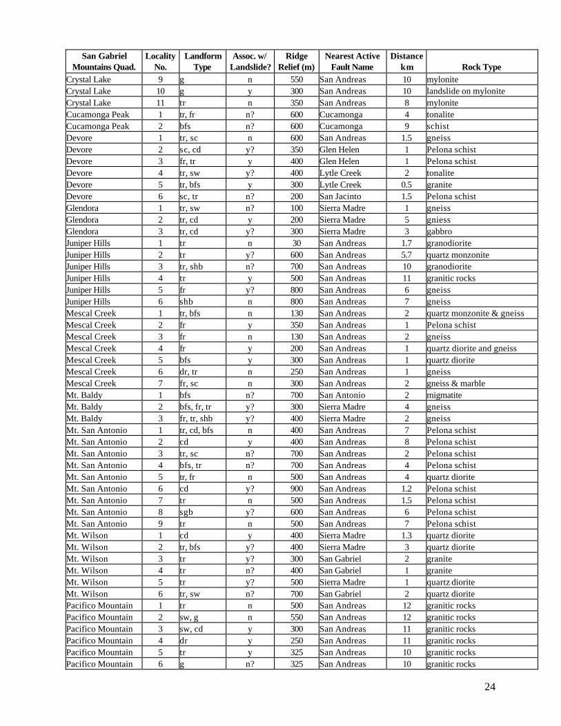
24
San Gabriel Mountains Quad.
Locality No.
Landform Type
Assoc. w/ Landslide?
Ridge Relief (m)
Nearest Active Fault Name
Distance km
Rock Type
Crystal Lake 9 g n 550 San Andreas 10 mylonite Crystal Lake 10 g y 300 San Andreas 10 landslide on mylonite Crystal Lake 11 tr n 350 San Andreas 8 mylonite Cucamonga Peak 1 tr, fr n? 600 Cucamonga 4 tonalite Cucamonga Peak 2 bfs n? 600 Cucamonga 9 schist Devore 1 tr, sc n 600 San Andreas 1.5 gneiss Devore 2 sc, cd y? 350 Glen Helen 1 Pelona schist Devore 3 fr, tr y 400 Glen Helen 1 Pelona schist Devore 4 tr, sw y? 400 Lytle Creek 2 tonalite Devore 5 tr, bfs y 300 Lytle Creek 0.5 granite Devore 6 sc, tr n? 200 San Jacinto 1.5 Pelona schist Glendora 1 tr, sw n? 100 Sierra Madre 1 gneiss Glendora 2 tr, cd y 200 Sierra Madre 5 gniess Glendora 3 tr, cd y? 300 Sierra Madre 3 gabbro Juniper Hills 1 tr n 30 San Andreas 1.7 granodiorite Juniper Hills 2 tr y? 600 San Andreas 5.7 quartz monzonite Juniper Hills 3 tr, shb n? 700 San Andreas 10 granodiorite Juniper Hills 4 tr y 500 San Andreas 11 granitic rocks Juniper Hills 5 fr y? 800 San Andreas 6 gneiss Juniper Hills 6 shb n 800 San Andreas 7 gneiss Mescal Creek 1 tr, bfs n 130 San Andreas 2 quartz monzonite & gneiss Mescal Creek 2 fr y 350 San Andreas 1 Pelona schist Mescal Creek 3 fr n 130 San Andreas 2 gneiss Mescal Creek 4 fr y 200 San Andreas 1 quartz diorite and gneiss Mescal Creek 5 bfs y 300 San Andreas 1 quartz diorite Mescal Creek 6 dr, tr n 250 San Andreas 1 gneiss Mescal Creek 7 fr, sc n 300 San Andreas 2 gneiss & marble Mt. Baldy 1 bfs n? 700 San Antonio 2 migmatite Mt. Baldy 2 bfs, fr, tr y? 300 Sierra Madre 4 gneiss Mt. Baldy 3 fr, tr, shb y? 400 Sierra Madre 2 gneiss Mt. San Antonio 1 tr, cd, bfs n 400 San Andreas 7 Pelona schist Mt. San Antonio 2 cd y 400 San Andreas 8 Pelona schist Mt. San Antonio 3 tr, sc n? 700 San Andreas 2 Pelona schist Mt. San Antonio 4 bfs, tr n? 700 San Andreas 4 Pelona schist Mt. San Antonio 5 tr, fr n 500 San Andreas 4 quartz diorite Mt. San Antonio 6 cd y? 900 San Andreas 1.2 Pelona schist Mt. San Antonio 7 tr n 500 San Andreas 1.5 Pelona schist Mt. San Antonio 8 sgb y? 600 San Andreas 6 Pelona schist Mt. San Antonio 9 tr n 500 San Andreas 7 Pelona schist Mt. Wilson 1 cd y 400 Sierra Madre 1.3 quartz diorite Mt. Wilson 2 tr, bfs y? 400 Sierra Madre 3 quartz diorite Mt. Wilson 3 tr y? 300 San Gabriel 2 granite Mt. Wilson 4 tr n? 400 San Gabriel 1 granite Mt. Wilson 5 tr y? 500 Sierra Madre 1 quartz diorite Mt. Wilson 6 tr, sw n? 700 San Gabriel 2 quartz diorite Pacifico Mountain 1 tr n 500 San Andreas 12 granitic rocks Pacifico Mountain 2 sw, g n 550 San Andreas 12 granitic rocks Pacifico Mountain 3 sw, cd y 300 San Andreas 11 granitic rocks Pacifico Mountain 4 dr y 250 San Andreas 11 granitic rocks Pacifico Mountain 5 tr y 325 San Andreas 10 granitic rocks Pacifico Mountain 6 g n? 325 San Andreas 10 granitic rocks

25
San Gabriel Mountains Quad.
Locality No.
Landform Type
Assoc. w/ Landslide?
Ridge Relief (m)
Nearest Active Fault Name
Distance km
Rock Type
Pasadena 1 sw, bfs n 250 Sierra Madre 3 granite Pasadena 2 sw. cd n 400 Sierra Madre 1.3 granite San Fernando 1 shb, sw n? 400 Hospital/Lopez 1 quartz diorite San Fernando 2 tr, cd y 200 San Gabriel 0.3 quartz diorite San Fernando 3 bfs n 300 Lopez 1 quartz diorite San Fernando 4 tr, shb y? 300 Hospital/Lopez 3 granite Sunland 1 tr n 75 San Gabriel 1 gneiss Sunland 2 tr n 300 San Fernando 3 quartz diorite Sunland 3 tr y? 200 San Fernando 1 quartz diorite Sunland 4 tr, cd y 125 San Fernando 0.6 quartz diorite Sunland 5 dr, tr, bfs y? 700 Sunland 1 quartz diorite Sunland 8 shb, tr y? 200 San Gabriel 1 quartz diorite Telegraph Peak 1a bfs, cd n? 300 San Andreas 2 Pelona schist Telegraph Peak 1b bfs y 300 San Andreas 1 Pelona schist Telegraph Peak 1c tr y 400 San Andreas 1 Pelona schist Telegraph Peak 1d tr, sc y 300 San Andreas 1.3 Pelona schist Telegraph Peak 1e sw, tr y 300 San Andreas 1.3 Pelona schist Telegraph Peak 1f tr y 100 San Andreas 1 Pelona schist Telegraph Peak 1g tr, cd y 200 San Andreas 1 Pelona schist Telegraph Peak 1h tr, cd y 400 San Andreas 1.5 Pelona schist Telegraph Peak 1i tr y? 300 San Andreas 1 Pelona schist Telegraph Peak 1j bfs, cd y? 300 San Jacinto 1.6 Pelona schist Telegraph Peak 2a bfs n 200 San Jacinto 1 granodiorite Telegraph Peak 2b bfs n 300 San Andreas 1 granodiorite Telegraph Peak 3a tr n? 250 San Andreas 0.7 gneiss Telegraph Peak 3b tr, bfs y 250 San Andreas 0.9 gneiss Telegraph Peak 3c tr, bfs, cd y? 250 San Andreas 1 gneiss Telegraph Peak 3d cd. tr, bfs n? 275 San Andreas 0.9 gneiss Telegraph Peak 3e tr, cd n 400 San Andreas 1.3 gneiss Telegraph Peak 3f tr y 400 San Andreas 1.3 gneiss Telegraph Peak 3g tr y? 400 San Andreas 1 gneiss Telegraph Peak 3h shb y 400 San Andreas 1 gneiss Telegraph Peak 4 tr, sc n? 500 San Andreas 7 Pelona schist Valyermo 2 tr, g n 100 San Andreas 4 mylonite Waterman Mtn. 1 tr y? 150 San Andreas 14 granite Waterman Mtn. 1a tr n 250 San Andreas 13 granite Waterman Mtn. 2 tr y 130 San Andreas 14 granite Waterman Mtn. 3 tr y 175 San Andreas 16 granite Waterman Mtn. 4 cd y 300 San Andreas 16 granite Waterman Mtn. 5 tr, dr n 400 San Andreas 12 granite Waterman Mtn. 6 tr, shb y 500 San Andreas 16 granite Waterman Mtn. 7 sc y 550 San Andreas 13 granodiorite Waterman Mtn. 7a dr, bfs n 200 San Andreas 13 granodiorite
1tr, trough; cd, closed depression; shb, sidehill bench; fr, failed ridge; dr, anomalous drainage; bfs, back-facing scarp; vl, vegetation lineament; sc, downhill-facing scarp; g, graben; sw, swale.

26
Fig. 6. Relief of ridge containing anomalous landform in crystalline rocks, San Gabriel Mountains.

27
Fig. 7. Distance between ridge landform in crystalline rocks and nearest Late Quaternary fault, San Gabriel Mountains.
28
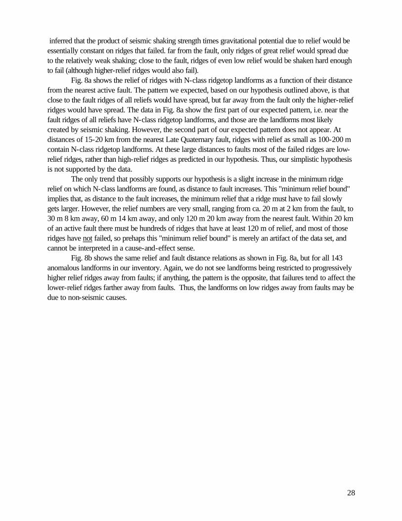
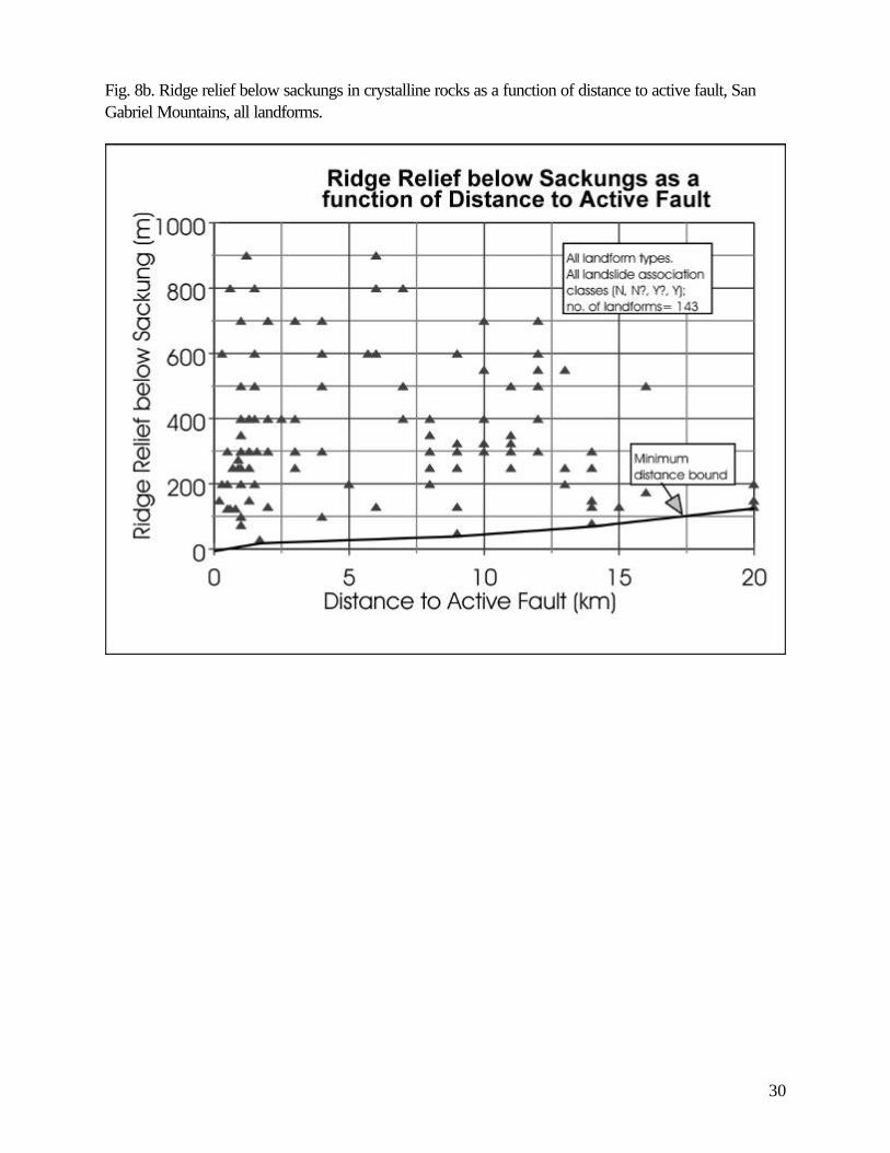
inferred that the product of seismic shaking strength times gravitational potential due to relief would be essentially constant on ridges that failed. far from the fault, only ridges of great relief would spread due to the relatively weak shaking; close to the fault, ridges of even low relief would be shaken hard enough to fail (although higher-relief ridges would also fail). Fig. 8a shows the relief of ridges with N-class ridgetop landforms as a function of their distance from the nearest active fault. The pattern we expected, based on our hypothesis outlined above, is that close to the fault ridges of all reliefs would have spread, but far away from the fault only the higher-relief ridges would have spread. The data in Fig. 8a show the first part of our expected pattern, i.e. near the fault ridges of all reliefs have N-class ridgetop landforms, and those are the landforms most likely created by seismic shaking. However, the second part of our expected pattern does not appear. At distances of 15-20 km from the nearest Late Quaternary fault, ridges with relief as small as 100-200 m contain N-class ridgetop landforms. At these large distances to faults most of the failed ridges are low-relief ridges, rather than high-relief ridges as predicted in our hypothesis. Thus, our simplistic hypothesis is not supported by the data. The only trend that possibly supports our hypothesis is a slight increase in the minimum ridge relief on which N-class landforms are found, as distance to fault increases. This "minimum relief bound" implies that, as distance to the fault increases, the minimum relief that a ridge must have to fail slowly gets larger. However, the relief numbers are very small, ranging from ca. 20 m at 2 km from the fault, to 30 m 8 km away, 60 m 14 km away, and only 120 m 20 km away from the nearest fault. Within 20 km of an active fault there must be hundreds of ridges that have at least 120 m of relief, and most of those ridges have not failed, so prehaps this "minimum relief bound" is merely an artifact of the data set, and cannot be interpreted in a cause-and-effect sense. Fig. 8b shows the same relief and fault distance relations as shown in Fig. 8a, but for all 143 anomalous landforms in our inventory. Again, we do not see landforms being restricted to progressively higher relief ridges away from faults; if anything, the pattern is the opposite, that failures tend to affect the lower-relief ridges farther away from faults. Thus, the landforms on low ridges away from faults may be due to non-seismic causes.
29
Fig. 8a. Ridge relief below sackungs in crystalline rocks as a function of distance to active fault, San Gabriel Mountains, definite non-landslide-associated landforms.
30
Fig. 8b. Ridge relief below sackungs in crystalline rocks as a function of distance to active fault, San Gabriel Mountains, all landforms.

31
7. RIDGETOP SPREADING FLANKING THE SAN ANDREAS FAULT. In the northeastern part of the San Gabriel Mountains (Telegraph Peak quadrangle) the northwest-trending San Andreas fault lies in the linear valley of Lone Pine Canyon (Plate 21). This 0.5 km-wide valley is flanked by two parallel ridges (the Upper Lytle Creek Ridge to the southwest, the Circle Mountain ridge to the northeast), that rise 425-500 m and 250-375 m (respectively) above the valley floor. The Upper Lytle Creek Ridge is dominantly composed of the Pelona schist, whereas the Circle Mountain ridge is composed of granitic rocks with metamorphic inliers of gneiss and marble (Morton et al, 1989). Because both ridges are composed of crystalline rocks we include their landforms in the overall analysis of the San Gabriel Mountains (previous section). However, the overall morphology of these ridges is distinctly different from that of other ridges of similar relief (ca. 300-400 m) elsewhere in the core of the San Gabriel Mountains. Both Upper Lytle Creek and Circle Mountain ridges have very broad (50-100 m), flattened ridge crests and spatulate spur ridges that broaden into lobe-shapes at their bases. Morton and Sadler (1991) term these lower bedrock spur ridges "exploded ridges", because it appears that the rocks comprising them have been shattered as if by explosives, after which they "flowed" in a semi-solid state down into the rift valley. This type of spatulate, "exploded" spur ridges is not observed elsewhere in the San Gabriel Mountains. Morton and Sadler (1991) mapped many landslides as well as anomalous ridgetop landforms on both ridges. In their interpretation, most of the anomalous ridgetop landforms (mainly troughs, with minor back-facing scarps and a few shallow depressions) were directly associated with discrete, mappable flank landslides. Thus, their interpretation was that the ridges were so internally shattered, that shaking from M~8 earthquakes on the San Andreas fault caused pervasive vertical settling and horizontal extrusion of the entire ridge cross-section. Based on our field mapping, depressions on the ridge crests tend to be shallow and all have been scraped by bulldozers, so the chance of finding thick stratigraphic sections of fine-grained fills appears remote. However, some depressions do have linear scarps on their margins that may be underlain by fault planes with associated colluvial wedge stratigraphy. The depressions and scarps on spurs extending from the Upper Lytle Creek Ridge have not been graded but are vegetated and not easily accessible. 8. RIDGETOP SPREADING IN THE EASTERN SANTA SUSANA MOUNTAINS AND HILLS TO THE NORTH 8.1 General Physiography Our study includes a sub-area directly west of the San Gabriel Mountains (eastern Santa Susana Mountains and hills to the north) that is underlain by relatively soft late Cenozoic sedimentary rocks. This region, composed of the Simi Valley East, Oat Mountain, and Val Verde quadrangles, forms a contrast in both physiography and geology to the high and steep crystalline rock terrain of the San Gabriel Mountains. Coincidentally, this 3-quad area was the site of numerous landslides, ground cracks, and shattered ridgetops during the 1994 Northridge earthquake. For statistical purposes several of the sedimentary rock localities from the San Gabriel Mountains are included in this area. Ridges and valleys in this area trend E-W, parallel to the trend of reverse faults and folds in this part of the Transverse Ranges (Morton and Yerkes, 1987). The Santa Clara River and its tributaries form low-elevation valleys (typical valley-floor elevations of 250-300 m) above which rise highly dissected ridges with summit elevations of 600-700 m. Thus, the local relief of the highest ridges (350-400 m) is about half of that typical in the San Gabriel Mountains.

32
8.2 Summary of Ridgetop Landforms Ridgetop spreading in the weak sedimentary rocks of the eastern Santa Susana Mountains and hills to the north is more spatially associated with the pervasive landsliding than in the other sub-provinces we studied. 62% of anomalous ridgetop landforms are definitely (Y) or probably (Y?) associated with slides (Table 4). Some of these larger, thicker slides were probably triggered by prehistoric earthquake shaking, as suggested by the Martinez Grande slide, the largest landslide triggered by the 1994 Northridge earthquake (Harp and Jibson, 1996). However, the adjacent unnamed ridgetop features and associated prehistoric landslide were not reactivated in 1994, suggesting that the ridgetop features are not always reactivated in weak sedimentary rocks (McCrink, 1995). We tested the same three hypotheses for the 26 mapped anomalous sedimentary-rock landforms in this region as we did for the 143 crystalline-rock landforms in the San Gabriel Mountains. First, the relief of ridges containing, N-, N?-, Y?-, and Y-class landforms did not vary significantly among the classes (Fig. 9). Although the variance of relief values in the N and N? classes is small (24-41 m) compared to the means (180-188 m), and small compared to the variance in the Y? and Y classes, this may be an artifact of the small number of observations in each class (4 in the N class, 5 in the N? class). The mean relief in each class overlaps at one sigma. Thus, there is no significant difference among the relief of ridges that contain landforms in each of the four landslide-association classes. The second hypothesis is that N-class landforms would be found preferentially closer to faults than landforms of other classes. Again, the mean distance-to-fault values of all four classes overlap at one sigma (Fig. 10), which apparently disproves the hypothesis. Of course, the closest late Quaternary fault is only one possible (maybe not the most likely) candidate for a seismic shaking source that may have shaken the ridge in question. For example, ridgetop failures formed in 1994 at Locations 8 and 12 in the Val Verde quadrangle are 0.5 km and 0.8 km from the closest Late Quaternary fault, even though the causative seismogenic source in 1994 was the blind Northridge structure which may have its surface projection as the Oak Ridge fault, 3 km and 13 km away from those two locations. Large ridge-crest fissures and scarps also formed in 1994 at Location 2 and, possibly, at 3 in the Simi Valley East quadrangle at distances of 0.3 and 3 km of the Santa Susana thrust fault (which did not rupture at the surface during the earthauake). All of the four failure locations lie in the upper plate of the blind Northridge fault where intense landsliding was triggered by seismic shaking (Barrows et al, 1995; Harp and Jibson, 1996). Thus, our assumption that the closest late Quaternary fault to each ridgetop site is the most likely causative seismic source for shaking is probably not true in every case. Finally, there is not a clear pattern showing that more ridge relief is needed for failure at greater distances from active faults (Fig. 11).

33
Table 4. Spreadsheet of geomorphic parameters for anomalous ridgetop landforms in sedimentary rocks, mainly in the Eastern Santa Susana Mountains and hills to the north, listed by quadrangle. Santa Susana Mountains
Nearest Late Quaternary Fault
Quad. Locality Landform Assoc. w/ Ridge Name Distance Formation Rock Type2 No. Type1 Landslide? Relief (m) (km)
Oat Mountain 1 fr, sw n 150 Santa Susana 2 Towsley Fm. ss Oat Mountain 2 tr y 75 Santa Susana 2 Saugus Fm. ss,cgl Oat Mountain 3 tr, cd, sw y? 200 Santa Susana 2.5 Towsley Fm. ss Oat Mountain 4 tr, bfs y? 500 Santa Susana 1.8 Towsley Fm. ss/sh Oat Mountain 5 cd y 300 Santa Susana 1 Monterey Fm. sil.sh San Fernando 5 fr, sc, cd y 200 Santa Susana 2 Towsley ss Simi Valley East 1 tr n 200 Santa Susana 0 Saugus Fm. ss,cgl,clst Simi Valley East 2 bfs, shb, tr y 400 Santa Susana 0.3 Sisquoc Fm. sh+ Simi Valley East 3 tr n? 150 Santa Susana 3 Pico Fm. slts,clst Simi Valley East 4 tr, shb n 150 Simi 1.7 Pico Fm. ss Simi Valley East 5 tr y? 150 Santa Susana 3 Monterey Fm. sh Sunland 6 tr, cd y 125 San Fernando 1 Towsley Fm. cgl Sunland 7 tr, sc n? 200 San Fernando 1 Towsley Fm. cgl Val Verde 1 tr, shb y? 200 Santa Susana 3 Pico Fm. clst,slts,ss Val Verde 2 bfs, tr, cd y? 80 Santa Susana 5 Pico Fm. ss Val Verde 3 tr, cd, bfs y 200 Holser 0.2 Pico Fm. clst,slts Val Verde 4 tr, bfs, cd y 300 Holser 1.7 Towsley Fm. cgl Val Verde 5 tr, cd n 250 Oakridge 1.5 Towsley Fm. ss Val Verde 6 bfs, cd y? 300 Holser 1 Pico Fm. clst,slts Val Verde 7 tr, bfs n? 200 Del Valle 0.4 Pico Fm. clst,slts Val Verde 8 g, cd y 300 Del Valle 0.5 Pico Fm. slts,clst Val Verde 9 tr n? 200 Holser 5 Towsley Fm. cgl Val Verde 10 tr, cd y 150 Holser 1.3 Pico Fm. ss Val Verde 11 fr y 150 Holser 5 Pico Fm. ss Val Verde 12 tr, cd n? 150 Holser 0.8 Pico Fm. ss Valyermo 1 g n 350 San Andreas 0.8 Punchbowl ss 1 tr, trough; cd, closed depression; bfs, back-facing scarp; g, graben; sw, swale; sc, downshill-facing scarp; fr, failed ridge; shb, sidehill bench 2 cgl, conglomerate; ss, sandstone; slts, silstone; clst, claystone; sh, shale

34
Fig. 9. Relief of ridge containing anomalous landform in sedimentary rocks, mostly in the Eastern Santa Susana Mountains and hills to the north.

35
Fig. 10. Distance between ridge landform in sedimentary rocks, and nearest Late Quaternary fault, Eastern Santa Susana Mountains and hills to the north.

36
Fig. 11. Ridge relief below sackungs in sedimentary rocks as a function of distance to active fault, Eastern Santa Susana Mountains and hills to the north, all landforms.
37
9. CONCLUSIONS--CONTROLS ON RIDGETOP SPREADING IN SOUTHERN CALIFORNIA According to our bivariate analyses of the relationships between anomalous landforms, ridge relief, and distance to faults, the locations of anomalous ridgetop landforms do not vary significantly from those of landslides. Most anomalous ridgetop landforms that are not visibly associated with landslides occur on ridges of relatively low relief, as do landforms that are possibly or probably associated with landslides. Most anomalous ridgetop landforms not visibly associated with landslides occur close to Late Quaternary faults, but then so do ridgetop landforms that are possibly and probably associated with landslides. Although we did not perform a rigorous bivariate analysis of the abundance of ridgetop landforms as a function of rock type or strucure, we can make some general observations. Weak sedimentary rocks and highly fractured rocks such as the Pelona schist near the San Andreas fault apparently fail more readily than other rock types. Structure seems to play a role in creating ridgetop landforms, at least in defining the geometry of landforms, particularly where relatively strong rocks are interbedded with weak rocks and dip is steep. Where crystalline rocks are highly fractured (e.g. Pelona schist) they tend to act like weak rocks. A rigorous comparison of the density of anomalous ridgetop landforms over the outcrop area of each rock type would require measuring the outcrop areas of all rock types, a task beyond the scope of this project. Our statistical results suggest that anomalous ridgetop landforms not visibly associated with landslides are responding to the same causal mechanisms as all other anomalous ridgetop landforms, even those clearly associated with landslides. In other words, all of these slope failures probably share a common origin, whether that origin is seismic shaking or climatic triggers or both. This conclusion reinforces the idea that our four landside-association classes are arbitrary subdivisions of a geomorphic continuum. Within this continuum exist failures, the most incipient stage of which would result in diffuse lateral spreading of a ridge, without the formation of a throughgoing failure plane; this incipient failure creates isolated ridgetop grabens and troughs with no evidence of instability on the ridge flanks. A more advanced failure would be partial detachment of one flank of the ridge, or such a multiplicity of diffuse subsurface failure planes that the ridge flank "extrudes" into the adjacent valley, as occurs on Lytle Creek and Circle Mountain ridges. This failure mode creates more abundant networks of ridgetop graben, depressions, and troughs, along with evidence of suspected or definite failures on ridge flanks, or at least suspicious hummocky topography on ridge flanks. Finally, discrete ridge-flank landslides may occur. The headscarps of these failures may reach the ridge crest and become integrated as graben, or as back-facing scarps on the opposite side of the ridge. Alternatively, the clear headscarp may occur downslope of the ridge crest, but debuttressing due to detachment of the flank slide mass may induce strong enough extensional stresses at the ridge crest that troughs and depressions are created. The idea that our mapped anomalous landforms form a slope-failure continuum is further supported by the difficulty we had in classifying the landforms into morphologic types (i.e., graben, closed depressions, troughs, back-facing scarps, etc.). Many of the mapped landforms contain multiple morphologic types (e.g., a trough that contains closed depressions along its axis), or the landforms change along strike.

38
10. RECOMMENDATIONS Our mapping documents that anomalous ridgetop landforms are numerous in the San Gabriel and Santa Susana Mountains, and that many sites (37% of the San Gabriel sites, 16% of the Santa Susana sites) are not associated with any visible signs of landsliding. These sites may represent deep-seated gravitational spreading due to earthquake shaking. However, our factor analysis indicates that the spatial distribution of these suspected spreading landforms, with respect to ridge relief and distance to Late Quaternary faults, is essentially identical to that of landslides. Thus, it seems that if these spreading landforms represent the results of earthquake shaking, than so do many (most?) of the landslides that we mapped. If the above hypothesis is true, then spreading landforms in our area (as well as most of the landslides) will not have random ages, but instead will be the same age as the strong earthquake shaking events that created them. Thus, dating these landforms and establishing their contemporaneity with each other, as well as with independently-dated paleoearthquakes, would be the best evidence for their earthquake-shaking origin. The best way to date these ridgetop landforms is to trench them and apply standard paleoseismic techniques and dating methods to the trench stratigraphy. Accordingly, we recommend that a program of trenching the best N-class sites be initiated. Such a program has been funded by NEHRP for summer of 1999 (see McCalpin and Hart, 2000). 11. REFERENCES Barrows, A. G., 1986, Landslide hazards in the east 1/2 of the Val Verde quadrangle, Los Angeles County, California: California Division of Mines and Geology Open-File Report 86-9, 2 sheets. Barrows, A.G., Irvine, P.J., and Siang, S.T., 1995, Geologic surface effects triggered by the Northridge earthquake in M.C. Woods and W.R. Seiple, editors, The Northridge, California, Earthquake of 17 January 1994: California Division of Mines and Geology Special Publication 116, p. 65-88. Barrows, A.G., Kahle, J.E., Weber, F.H., Jr., Saul, R.B., and Morton, D.M., 1974, Surface effects maps of the San Fernando earthquake area: California Division of Mines and Geology Bulletin 196, pl. 3. Barton, N.R., 1971, A model study of the behavior of steep excavated slopes: Ph.D. thesis, Imperial College, University of London, London, England, 520 p. Beck, A.C., 1968, Gravity faulting as a mechanism of topographic adjustment: New Zealand Journal of Geology and Geophysics, v. 11, p. 191-199. Bovis, M.J., 1982, Uphill-facing (antislope) scarps in the Coast Mountains, southwest British Columbia: Geological Society of America Bulletin, v. 93, p. 804-812. Bortugno, E. J., and Spittler, T. E., 1986, Geologic map of the San Bernardino quadrangle: California Division of Mines and Geology Regional Geologic Map No. 3A, 5 sheets.

39
CDMG, 1992, Preliminary fault activity map of California: California Division of Mines & Geology, Open-File Report 92-03, scale 1:750,000, Appendix 76 p. California Division of Mines and Geology, 1997, Guidelines for evaluating and mitigating seismic hazards in California: Special Publication 117, 74 p. Clague, J.J., 1979, The Denali Fault system in southwest Yukon Territory-- a geologic hazard?: Current Research, Geological Survey of Canada Paper 79-1A, p. 169-178. Clague, J.J., 1980, The role of geomorphology in the identification and evaluation of natural hazards, in Craig, R.S. and Craft, J.L. (eds.), Applied geomorphology, Proceedings of the 11th annual Binghampton symposium on geomorphology, p. 17-43: Allen and Unwin, Boston. Clague, J.J. and Evans, S.G., 1994, A gravitational origin for the Hell Creek 'fault', British Columbia: Current Research 1994-A, Geological Survey of Canada, p. 193-200. Cotton, C.A., 1950, Tectonic scarps and fault valleys: Geological Society of America Bulletin, v. 61, p. 717-758. Dibblee, T.W. Jr., 1989, Geologic map of the Pasadena quadrangle, Los Angeles County, California: Dibblee Geological Foundation, Map #DF-23, scale 1:24,000. Dibblee, T.W. Jr., 1991a, Geologic map of the Sunland and Burbank (North 1/2) quadrangles, Los Angeles County, California: Dibblee Geological Foundation, Map #DF-32, scale 1:24,000. Dibblee, T. W., Jr., 1991b, Geologic map of the San Fernando and Van Nuys (north 1/2) quadrangles, Los Angeles County, California: Dibblee Geological Foundation Map #DF-33. Dibblee, T. W., Jr., 1992a, Geologic map of the Oat Mountain and Canoga Park (north 1/2) quadrangles, Los Angeles County, California: Dibblee Geological Foundation Map #DF-36. Dibblee, T. W., Jr. 1992b, Geological Map of the Santa Susana (Simi Valley East) quadrangle, Ventura and Los Angeles counties, California: Dibblee Geological Foundation Map #DF-68. Dibblee, T. W. Jr., 1993, Geologic map of the Val Verde quadrangle, Los Angeles and Ventura counties, California: Dibblee Geological Foundation Map #DF-50. Dibblee, T.W. Jr., 1996a, Geologic map of the Aqua Dulce quadrangle, Los Angeles County, California: Dibblee Geological Foundation, Map #DF-58, scale 1:24,000. Dibblee, T.W. Jr., 1996b, Geologic map of the Acton quadrangle, Los Angeles County, California: Dibblee Geological Foundation, Map #DF-59, scale 1:24,000.

40
Dibblee, T.W. Jr., 1998, Geologic map of the Mt. Wilson quadrangle, Los Angeles County, California: Dibblee Geological Foundation, Map #DF-67, scale 1:24,000. Ertec Northwest, Inc., 1981, The origin(s) of uphill-facing scarps, North Cascade Range, washington: unpublished report by Ertec Northwest, Inc., Seattle, WA submitted to Puget Sound Power and Light Co., Nov. 1981, report no. 81-513, 77 p. Evans, J. G., 1982, Geology of the Sheep Mountain Wilderness Study Area and the Cucamonga Wilderness and additions, Los Angeles and San Bernardino Counties, California: U. S. Geological Survey Bulletin 1506A, p. 5 - 28, Pl. 1. Florensov, N.A., 1960, On the neotectonics and seismicity of the Mongol-Baikal mountain area: Geology and Geophysics, v.1, p.79-90 (in Russian). Goodman, R.E. and Bray, J.W., 1976, Toppling of rock slopes, in Rock engineering: American Society of Civil Engineers, Geotechnical Engineering Division, Conference, Boulder, Colorado, v. II, p. 201-237. Harp, E.L., and Jibson, R.W., 1996, Landslides triggered by the 1994 Northridge Calfornia earthquake: Bulletin of the Seismological Society of America, v. 86, n. 1B, p. S319-S332, pl. 1. Hart, E.W., Bryant, W.A., Wills, C.J., and Treiman, J.A., 1990, The search for fault rupture and significance of ridgetop fissures, Santa Cruz Mountains, California in S.R. McNutt and R.H. Sydnor, editors, The Loma Prieta earthquake of 17 October 1989: California Division of Mines and Geology Special Publication 104, p. 83-94. Hartzell, S.H., Carver, D.L., and King , K.W., 1994, Initial investigation of site and topographic effects at Robinwood Ridge, California: Bulletin of the Seismological Society of America, v. 84, p. 1336-1349 Jahn, A., 1964, Slopes morphological features resulting from gravitation: Zeitschrift fur Geomorpholgie, Supplement Band 5, p. 59-72. Jennings, C. W., 1977, Geologic Map of California: California Division of Mines and Geology Geologic Data Map No. 2 Jennings, C. W., 1994, Fault activity map of California and adjacent areas and locations and ages of recent volcanic eruptions: California Division of Mines and Geology Geologic Data Map No. 6 Jennings, C. W., and Strand, R. G., 1969, Geologic Map of California Los Angeles sheet: California Division of Mines and Geology, Olaf P. Jenkins Edition. Jibson, R.W., Prentice, C.S., Borissoff, B.A., Rogozhin, E.A. and Langer, C.J., 1994, Some observations of landslides triggered by the 29 April 1991 Racha earthquake, Republic of Georgia: Bulletin of the Seismological Society of America, v. 84, p. 963-973.

41
Lawson, A.C., 1908, The California earthquake of April 18, 1906: Report of the State Earthquake Investigation Commission, Vol. I and II and Atlas: Carnegie Institution, Washington, DC. McCalpin, J.P., and Hart, E.W., 2000, Ridgetop splitting, spreading, and shattering related to earthquakes in southern California: Final Technical Report, Contract 99HQGR0042, National Earthquake Hazards Reduction Program, U.S. Geological Survey, 54 p. (unpublished). McCalpin, J.P. and Irvine, J.R., Sackungen at Aspen Highlands Ski Area, Pitkin County, Colorado: submitted to Environmental and Engineering Geology, Oct. 1994. McCalpin, J.P. and Khromovskikh, V.S., Holocene paleoseismicity of the central Tunka Fault, Baikal Rift Zone, Russia: submitted to Tectonics, Oct. 1994. McCleary, J., Dohrenwend, J., Cluff, L. and Hanson, K., 1978, 1872 earthquake studies, Washington Public Power Supply System Nuclear Project Nos. 1 and 4: unpublished report by Woodward-Clyde Consultants, San Francisco, CA submitted to United Engineers and Constructors, Inc., April 1978, contract No. 52028, 75 p. plus appendices. McCrink, T.P., 1995, Ridge-top landslide triggered by the Northridge earthquake: California Division of Mines and Geology Special Publication 116, p. 273-278. Morton, D. M., 1973, Geology of parts of Azusa and Mount Wilson quadrangles, San Gabriel Mountains, Los Angeles County, California: California Division of Mines and Geology Special Report 105, 21 p., 2 Pl. Morton and Matti, J. C., 1991, Geologic map of the Cucamonga Peak 7.5 minute quadrangle, San Bernardino County, California: U. S. Geological Survey Open-File Report 90-694, map, 7 p. Morton, D. M., and Matti, J. C., 1991, Geologic map of the Devore quadrangle, San Bernardino, California: U. S. Geological Survey Open-file Report 90-695, map 10 p. Morton, D. M., and Miller, F. K., 1975, Geology of the San Andreas fault zone north of San Bernardino between Cajon Canyon and Santa Ana Wash in J. C. Crowell, San Andreas fault in Southern California: California Division of Mines and Geology Special Report 118, p. 136 - 146. Morton, D.M. and Sadler, P.M., 1989, The failings of the Pelona Schist; landslides and sackungen in the Lone Pine Canyon and Wrightwood areas of the eastern San Gabriel Mountains, southern California, in Sadler, P.M. and Morton, D.M. (eds.), Landslides in a semi-arid environment, with emphasis on the inland valleys of southern California: Inland Geological Society, Publication 2, p. 301-322. Morton, D.M., Sadler, P.M., and Minnich, R.A., 1989, Large rock avalanche deposits: Examples from the central and eastern San Gabriel Mountains of Southern California in P.M. Saddler and D.M. Morton, editors, Landslides in a semi-arid environment: Inland Geological Society, v. 2, p. 323-337.

42
Morton, D.M., Campbell, R.H., Jibson, R.W., Wesson, R.L. and Nicholson, C., 1989, Ground fracturing and landsliding produced by the July 8, 1986 North Palm Springs earthquake, in Sadler, P.M. and Morton, D.M. (eds.), Landslides in a semi-arid environment, with emphasis on the inland valleys of southern California: Inland Geological Society, Publication 2, p. 183-196. Morton, D.M., Woodburne, M.D., and Foster, J.H., 1991, Geologic map of the Telegraph Peak quadrangle, San Bernardino County, California: U.S. Geological Survey Open-File Report 90-693, 10 p., 2 pl. Morton, D.M. and Yerkes, R.F., 1987, Introduction, in USGS, Recent reverse faulting in the Transverse Ranges, California: U.S. Geological Survey Professional Paper 1339, p. 1-7. Nemcok, A., 1972, Gravitational slope deformation in high mountains: 24th International Geological Congress, Montreal, Proceedings, Section 13, p. 132-141. Nikonov, A.A., 1981, The use of radiocarbon dating for age determination of old earthquakes in the mountains of southern Soviet central Asia: Izvestia Akademia Nauk SSSR, Solid Earth, v.9, p.70-75 (in Russian). Nikonov, A.A., 1988, Reconstruction of the main parameters of old large earthquakes in Soviet central Asia using the paleoseismogeological method: Tectonophysics, v.147, p.297-312. Noble, L.F., 1954, Geology of the Valyermo quadrangle and vicinity, California: U.S. Geological Survey Map GQ-50, scale 1:24,000. Nolan, J.M. and Weber, G.E., 1992, Evaluation of surface cracking caused by the 1989 Loma Prieta earthquake, Santa Cruz County, California: Case histories, in Sharma, S. (ed.), Proceedings of the 28th Symposium on Engineering Geology and Geotechnical Engineering: University of Idaho, Moscow, ID, p. 272-286. Nolan, J.M., and Weber, G.E., 1998, Evaluation of coseismic ground cracking accompanying the earthquake: Trenching studies and case histories in The Loma Prieta, California, earthquake of October 17, 1989 -- landslides: U.S. Geological Survey Professional paper 1551-C, p. 145-163, pl. 5. Ponti, D.J., and Wells, R.E., 1991, Off-fault ground ruptures in the Santa Cruz Mountains, California: Ridge-top spreading versus tectonic extension during the 1989 Loma Prieta earthquake: Bulletin of the Seismological Society of America, v. 81, p. 1480-1510. Radbruch-Hall, D.H., Varnes, D.J., and Savage, W.Z., 1976, Gravitational spreading of steep-sided ridges ("sackung") in western United States: International Association for Engineering Geology Bulletin, v. 14, p. 23-35. Radbruch-Hall, D.H., Varnes, D.J., and Colton, R.B., 1977, Gravitational spreading of steep-sided ridges in Colorado: U.S. Geological Survey Journal of Research, v. 5, p. 359-363.

43
Radbruch-Hall, D.H., 1978, Gravitational creep of rock masses on slopes, in Voight, B. (ed.), Rockslides and avalanches, v. 1, p. 607-657: Elsevier, Amsterdam. Rosenberg, L.I., 1990, Geological evaluation and soil engineering study, existing damage DeBoi residence, north Monterey County, California: Applied Soil Mechanics, unpublished consulting report prepared for American Red Cross, 39 p., 3 apps. (incomplete report filed with CDMG as C-921). Smith, D.P., 1978, Sierra Madre and related faults: California Division of Mines and Geology Fault Evaluation Report FER-69, 32 p., maps, 2 supps. (unpublished file report). Solonenko, V.P., 1970, The paleoseismogeological method, in Large earthquakes in Soviet central Asia and Khazakstan, vol. 1, Donish, Dushanbe, p.83-93 (in Russian). Solonenko, V.P., 1973, Paleoseismogeology: Izvestia Akademia Nauk SSSR, Solid Earth, v.9, p.3-16 (in Russian). Solonenko, V.P., 1977a, Seismic deformations and the paleoseismogeological method, in Gorshkov, G.P. (ed.) Seismicity and seismogeology of eastern Siberia: Nauka, Moscow, p.83-131 (In Russian). Solonenko, V.P., 1977b, Landslides and collapses in seismic zones and their prediction: Bulletin of the International Association of Engineering Geology, no. 15, p. 4-8. Solonenko, V.P. and Khromovskikh, V.S., 1978, Paleoseismogeological and seismotectonic basis for seismic zoning in the greater Caucasus, in Gubin, I.E. (ed.), Seismotectonics of the southern areas of the USSR: Nauka, Moscow, p.48-63 (in Russian). Spittler, T.E., and Harp, E.L., 1990, Preliminary map of landslide features and coseismic fissures triggered by the Loma Prieta, California, earthquake of October 17, 1989: California Division of Mines and Geology, Open-File Report 90-06, scale 1:4,800. (Same as USGS OF 90-688.) Tabor, R.W., 1971, Origin of ridge-top depressions by large-scale creep in the Olympic Mountains, Washington: Geological Society of America Bulletin, v. 82, p. 1811-1822. Technical Advisory Group on the Santa Cruz Geologic Hazard Investigation, 1991, Geologic hazards in the Summit Ridge area of the Santa Cruz Mountains, Santa Cruz County, California, evaluated in response to the 17 October 1989 Loma Prieta earthquake: Report of Technical Advisory Group: U.S. Geological Survey Open-File Report 91-618, 427 p., plates. Varnes, D.J., Radbruch-Hall, D.H., and Savage, W.Z., 1989, Topographic and structural conditions in areas of gravitational spreading of ridges in the western United States: U.S. Geological Survey Professional Paper 1496, 28p. Varnes, D.J., Radbruch-Hall, D.H., Varnes, K.L., Smith, W.K. and Savage, W.Z., 1990, Measurement of ridge-spreading movements (sackungen) at Bald Eagle Mountain, Lake County, Colorado, 1975-1989: U.S. Geological Survey Open-File Report 90-543, 13 p.

44
Wells, R.E., Ponti, D.J., Clark, M.M., Bucknam, R.C., Budding, K.E., Fumal, T.E., Harwood, D.S.,Lajoie, K.R., Lienkaemper, J.J., Machette, M.N., Prentice, C.S., and Schwartz, D.P., 1989, Preliminary map of fractures formed in the Summit Road-Skyland Ridge area during the Loma Prieta, California, earthquake of October 17, 1989: U.S. Geological Survey Open-File Report 89-686, 1 plate, scale 1:12,000. West, M.W., 1978, Quaternary geology and reported surface faulting along the east flank of the Gore Range, Summit County, Colorado: Colorado School of Mines Quarterly, 73(2): 1-66. Zischinsky, U., 1966, On the deformation of high slopes: International Society of Rock Mechanics, 1st Congress, Proceedings, v. 2, p. 179-185. Zischinsky, U., 1969, Uber sackungen: Rock Mechanics, v. 1, p. 30-52.

45
12. AERIAL PHOTOGRAPHS USED Fairchild Aerial Surveys, 1933, vertical, black and white, 1:19,200-scale, part of C-2878 series (collection at California Geological Survey (CGS), SF office). National Aeronautical and Space Administration (NASA), 1994, black and white, vertical, 1:12,000-scale, parts of flights flown 1/21/94 and 1/24/94 (collection at CGS, Sacramento office). U.S. Department of Agriculture, 1952-1953, black and white, vertical, 1:20,000-scale, parts of AXI (Ventura County) series (collection at CGS, SF office). U.S. Department of Agriculture, 1952-1954, black and white, vertical, 1:20,000-scale, parts of AXJ (Los Angeles County) series (collection at CGS, SF office). U.S. Department of Agriculture, 1953, black and white, vertical, 1:20,000-scale, parts of AXL (San Bernardino County) series (collection at CGS, SF office). U.S. Geological Survey, 1966, black and white, vertical, 1:12,000-scale, WRD series (San Andreas fault), (collection at CGS, LA office). U.S. Geological Survey, 1967, black and white, vertical, 1:12,000-scale, WRD series (San Jacinto fault), (collection at CGS, LA office). U.S. Forest Service, 1969, color, vertical, 1:15,000-scale (approx.), parts of EUX series (collection at CGS, SF office). U.S. Forest Service, 1978, color infrared, vertical, 1:24,000-scale, ASCD/FS series, parts of rolls 278, 378 and 478 (collection at GeoHaz Consultants, Colorado). U.S. Forest Service, 1980, black and white, vertical, 1:18,000-scale, AAS-36 to 213, flown 6/18/80 by Americal Aerical Surveys (collection at CGS, LA office). U.S. Forest Service, 1994, color, vertical, 1:15,000-scale ASCS/FS series, parts of Roll 194 (collection at GeoHaz Consultants, Colorado).

13. APPENDIX -- Inventory of Anomalous Landforms (arranged alphabetically by name of 7.5' quadrangle). NEHRP GRANT 98HQGR1026; RIDGETOP SPLITTING, SPREADING, AND SHATTERING RELATED TO EARTHQUAKES IN SOUTHERN CALIFORNIA Inventory of Anomalous Ridgetop Landforms Acton, CA 7.5’ Quadrangle Locality No.1
Airphoto Airphoto Interpretation2 Field Observations (Date) Associated with Landslide?
Ridge Relief (m)
Nearest Active Fault (Distance,km)
Rock Type/Formation
Comments/ References
1 278-122 + 123 broad, shallow tr coincident with old firebreak? N 80 San Andreas (14) anorthosite Dibblee, 1996b 2 278-123 + 124 depression and sloping bench on ridgecrest Y 250 San Andreas (9) Lowe granodiorite Dibblee (1996b) maps a slide here 3 278-141 + 142 flattened area at ridgecrest broad trough has a saddle at W end where campsites of Messenger Flats campground
are; remainder of trough is a low-gradient, grassy valley that drains to W; almost surely a pull-apart structure (26 May 1998)
Y? 200 San Andreas (20 anorthosite Dibblee (1996b) does not map slide here
4 278-141 + 142 near-circular drainage pattern at ridgecrest N 150 San Andreas (20) anorthosite Dibblee, 1996b 5 278-166 + 167 linear E-W trending trough that has no contributing
drainage area; north-facing scarp in bedrock approx. 300 m to south crosses ridge and road (twice) and deflects drainage
N? 150 San Andreas (20) anorthosite Dibblee (1996b) does not map a slide here
6 278-166 + 167 slightly arcuate N-S trending trough on E side of ridge at LA County Fire Camp ; S end has been obliterated by grading
N 130 San Andreas (20) Lowe granodiorite- hornblende facies
Dibblee (1996b) shows that foliation parallels this trough and dips E at 60°
7 278-166 + 167 1.2 km-long ridge-parallel drainage, deeply incised, on crest of ridge north of Mt. Gleason Road and east of Little Gleason Forestry Plantation
N 200 San Andreas (20) Lowe granodiorite- hornblende and porphyritic facies
Dibblee (1996b) does not map any structure parallel to this trough; trough trends perpendicular to foliation
8 278-167 + 168 N-S trending sidehill benches and shallow troughs, probably erosional
N 130 San Andreas (15) Lowe granodiorite- hornblende facies
Dibblee (1996b) shows troughs parallel foliation, which dips 50° E
9 278-167 + 168 bfs between 2 strands of access road; may be artificial N 300 San Andreas (14) Lowe granodiorite- porphyritic facies
Dibblee (1996b) shows foliation trending about 30° more westerly than strike of bfs
1 refer to Plate 5 2 abbreviations: tr-trough; shb- sidehill bench; sw- swale; ls - landslide; cd- closed depression; bfs- back (uphill)-facing scarp; ss- sandstone; sh- shale; slts- siltstone; cgl- conglomerate; sch- schist; gn- gneiss; gr- granitic rocks; dg- decomposed granitic rocks; fm- formation.

NEHRP GRANT 98HQGR1026; RIDGETOP SPLITTING, SPREADING, AND SHATTERING RELATED TO EARTHQUAKES IN SOUTHERN CALIFORNIA Inventory of Anomalous Ridgetop Landforms Agua Dulce, CA 7.5’ Quadrangle Locality No.1
Airphoto Airphoto Interpretation2 Field Observations (Date) Associated with Landslide?
Ridge Relief (m)
Nearest Active Fault (Distance,km)
Rock Type/Formation
Comments/ References
1 278-120 + 121 2 shallow tr and shb; shb may be dozer scrape N 50 San Gabriel (9) anorthosite Dibblee (1996a) shows foliation parallel to tr/shb and dipping 40-70° W
2 278-93 + 94 2 anomalous drainage heads bend to parallel ridgecrest; they are erosional, but may be following ridge-parallel tension cracks
N 200 San Gabriel (8) anorthosite Dibblee (1996a)
3 278-93 + 94 2 probable landslides, each of which contain linear troughs; the NE slide(?) has a pair of NW-trending troughs that bound a hummocky, low part of the ridgecrest; the SW slide(?) contains a single trough that cuts across the back of a bench (back-rotated block?)
Y 300 San Gabriel (8) anorthosite Dibblee (1996a)
4 278-65 + 66 E-W trending short trough at summit of steep peak, 0.5 km N of a saddle created by the Magic Mountain fault
N 130 San Gabriel (6) anorthosite Dibblee (1996a)
5 278-66 + 67 vegetation lineament with no visible relief on ridgetop, possibly an old firebreak
N 300 San Gabriel (8) mafic complex Dibblee (1996a)
6 278-66 + 67 trough on ridge nose, and shb on S flank of ridge; trough may be associated with possible old slide to N; shb may be a purely erosional feature
Y? 130 San Gabriel (9) anorthosite Dibblee (1996a)
1 refer to Plate 4 2 abbreviations: tr-trough; shb- sidehill bench; sw- swale; ls - landslide; cd- closed depression; bfs- back (uphill)-facing scarp; ss- sandstone; sh- shale; slts- siltstone; cgl- conglomerate; sch- schist; gn- gneiss; gr- granitic rocks; dg- decomposed granitic rocks; fm- formation.
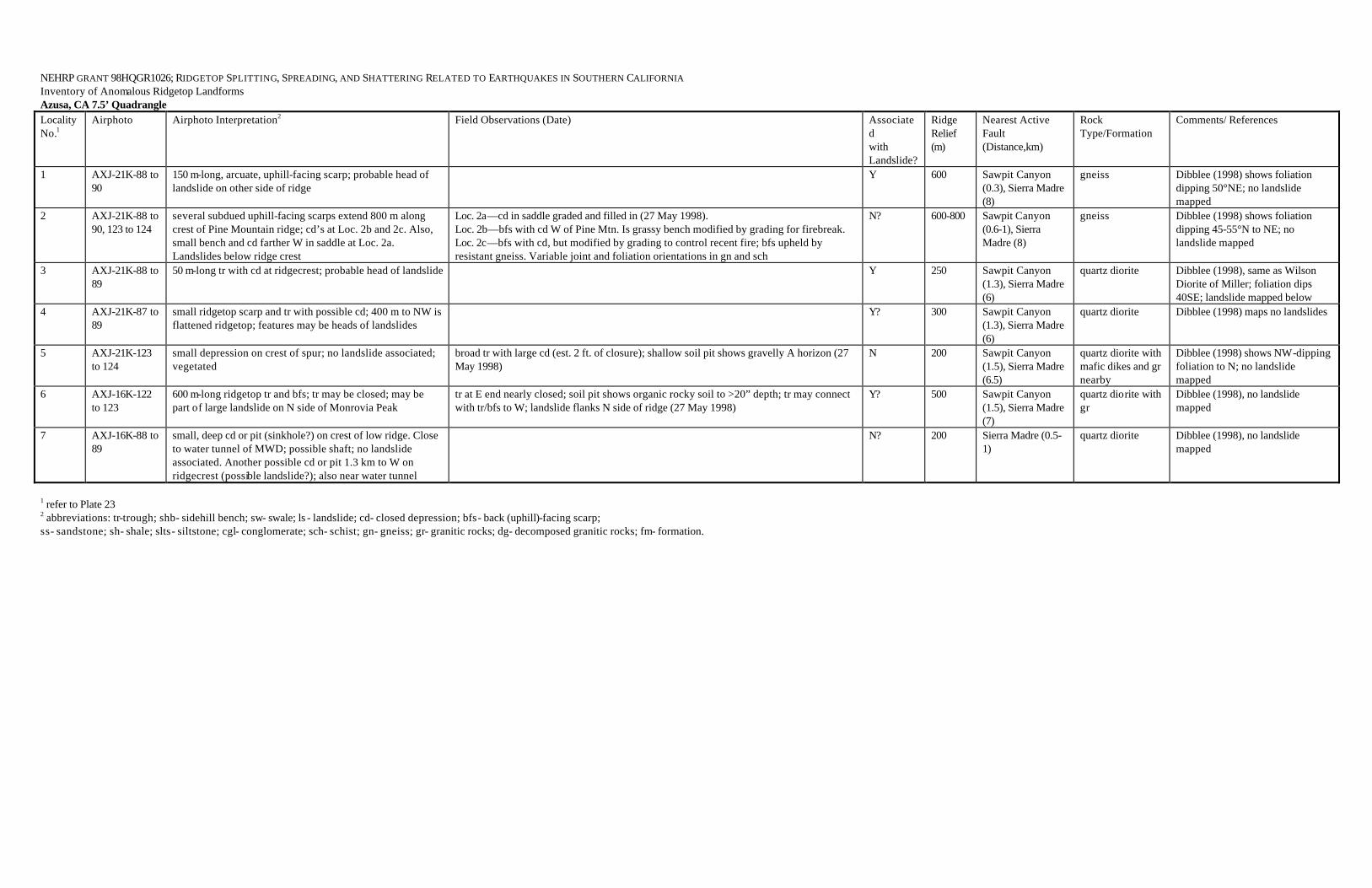
NEHRP GRANT 98HQGR1026; RIDGETOP SPLITTING, SPREADING, AND SHATTERING RELATED TO EARTHQUAKES IN SOUTHERN CALIFORNIA Inventory of Anomalous Ridgetop Landforms Azusa, CA 7.5’ Quadrangle Locality No.1
Airphoto Airphoto Interpretation2 Field Observations (Date) Associated with Landslide?
Ridge Relief (m)
Nearest Active Fault (Distance,km)
Rock Type/Formation
Comments/ References
1 AXJ-21K-88 to 90
150 m-long, arcuate, uphill-facing scarp; probable head of landslide on other side of ridge
Y 600 Sawpit Canyon (0.3), Sierra Madre (8)
gneiss Dibblee (1998) shows foliation dipping 50°NE; no landslide mapped
2 AXJ-21K-88 to 90, 123 to 124
several subdued uphill-facing scarps extend 800 m along crest of Pine Mountain ridge; cd’s at Loc. 2b and 2c. Also, small bench and cd farther W in saddle at Loc. 2a. Landslides below ridge crest
Loc. 2a—cd in saddle graded and filled in (27 May 1998). Loc. 2b—bfs with cd W of Pine Mtn. Is grassy bench modified by grading for firebreak. Loc. 2c—bfs with cd, but modified by grading to control recent fire; bfs upheld by resistant gneiss. Variable joint and foliation orientations in gn and sch
N? 600-800 Sawpit Canyon (0.6-1), Sierra Madre (8)
gneiss Dibblee (1998) shows foliation dipping 45-55°N to NE; no landslide mapped
3 AXJ-21K-88 to 89
50 m-long tr with cd at ridgecrest; probable head of landslide Y 250 Sawpit Canyon (1.3), Sierra Madre (6)
quartz diorite Dibblee (1998), same as Wilson Diorite of Miller; foliation dips 40SE; landslide mapped below
4 AXJ-21K-87 to 89
small ridgetop scarp and tr with possible cd; 400 m to NW is flattened ridgetop; features may be heads of landslides
Y? 300 Sawpit Canyon (1.3), Sierra Madre (6)
quartz diorite Dibblee (1998) maps no landslides
5 AXJ-21K-123 to 124
small depression on crest of spur; no landslide associated; vegetated
broad tr with large cd (est. 2 ft. of closure); shallow soil pit shows gravelly A horizon (27 May 1998)
N 200 Sawpit Canyon (1.5), Sierra Madre (6.5)
quartz diorite with mafic dikes and gr nearby
Dibblee (1998) shows NW-dipping foliation to N; no landslide mapped
6 AXJ-16K-122 to 123
600 m-long ridgetop tr and bfs; tr may be closed; may be part of large landslide on N side of Monrovia Peak
tr at E end nearly closed; soil pit shows organic rocky soil to >20” depth; tr may connect with tr/bfs to W; landslide flanks N side of ridge (27 May 1998)
Y? 500 Sawpit Canyon (1.5), Sierra Madre (7)
quartz diorite with gr
Dibblee (1998), no landslide mapped
7 AXJ-16K-88 to 89
small, deep cd or pit (sinkhole?) on crest of low ridge. Close to water tunnel of MWD; possible shaft; no landslide associated. Another possible cd or pit 1.3 km to W on ridgecrest (possible landslide?); also near water tunnel
N? 200 Sierra Madre (0.5-1)
quartz diorite Dibblee (1998), no landslide mapped
1 refer to Plate 23 2 abbreviations: tr-trough; shb- sidehill bench; sw- swale; ls - landslide; cd- closed depression; bfs- back (uphill)-facing scarp; ss- sandstone; sh- shale; slts- siltstone; cgl- conglomerate; sch- schist; gn- gneiss; gr- granitic rocks; dg- decomposed granitic rocks; fm- formation.

NEHRP GRANT 98HQGR1026; RIDGETOP SPLITTING, SPREADING, AND SHATTERING RELATED TO EARTHQUAKES IN SOUTHERN CALIFORNIA Inventory of Anomalous Ridgetop Landforms Cajon, CA 7.5’ Quadrangle Locality No.1
Airphoto Airphoto Interpretation2 Field Observations (Date) Associated with Landslide?
Ridge Relief (m)
Nearest Active Fault (Distance,km)
Rock Type/Formation
Comments/ References
1 AXL-35K-81 to 83
sharp 150 m-long trough at ridgecrest, appears to be part of a landslide scarp; SE end of ridge is flattened (failed ridge= FR) with subprallel troughs, scarps, and cd, which grades into a massive landslide
Y 300 San Andreas (2) Pelona schist Bortugno & Spittler (1986; CDMG Geol. Map of San Bernadino sheet)
2 AXL-34K-35 to 37
well-developed uphill-facing scarp 1/3 of the way down below the ridgecrest; no landslide associated (above or below)
N 150 San Andreas (1.3) gneiss Bortugno & Spittler (1986)
3 AXL-31K-147 to 149
broad ridgecrest scarp that is arcuate; mimics arcuate ls scar to W; ls scar may have thin ls deposits; arcuate scarp appears to be an incipient ls scarp
Y 400 San Andreas (2.5) gneiss Bortugno & Spittler (1986)
4 WRD 875 to 876
broad trough with possible cd; may be in part a terrace surface rotated into the hill; partly eroded; no landslide
N 125 San Andreas (0.8) Pelona schist overlain by Pleistocene alluvium
Morton & Miller (1975, CDMG Spec. Rept. 118, p. 136-146)
1 refer to Plate 22 2 abbreviations: tr-trough; shb- sidehill bench; sw- swale; ls - landslide; cd- closed depression; bfs- back (uphill)-facing scarp; FR- flattened (failed) ridge; ss- sandstone; sh- shale; slts- siltstone;clst- claystone; cgl- conglomerate; sch- schist; gn- gneiss; gr- granitic rocks; dg- decomposed granitic rocks; fm- formation.

NEHRP GRANT 98HQGR1026; RIDGETOP SPLITTING, SPREADING, AND SHATTERING RELATED TO EARTHQUAKES IN SOUTHERN CALIFORNIA Inventory of Anomalous Ridgetop Landforms Chilao Flat, CA 7.5’ Quadrangle Locality No.1
Airphoto Airphoto Interpretation2 Field Observations (Date) Associated with Landslide?
Ridge Relief (m)
Nearest Active Fault (Distance,km)
Rock Type/Formation
Comments/ References
1 AXJ-16K-4 to 5; EUX-9-40 to 41
large ridgecrest depression, closed; 100 m by 200 m; possible landslides to N and S
Loc. 1—large cd with nearly flat floor and gentle slope to S toward main scarp in granitic rocks (partly decomposed), with main joints striking N40-50W and N40-50E; granodiorite on N rim is partly decomposed and has variable joints: (1) strike N15-30W & dip 35-55NE; (2) strike N65-80W & dip 65-80SW; (3) strike N30E, dip 90. Surface of cd covered with angular granitic pebbles; soil pit to 2 ft depth shows granitic, pebbly soil with A horizon to 8-10” and C horizon below; POSSIBLE TRENCH SITE, but no road access (21 May 1998)
N? ~500 San Gabriel (1.5), Sierra Madre (4)
granitic rocks Jennings & Strand (1969)
2 278-207 + 208 several sharp, steep troughs trending down a steep slope, with the southmost curving northward to bound a shb; may indicate deep-seated failure of this entire mountain slope
N 300 San Gabriel (10) granitic rocks Jennings & Strand (1969)
3a 378-13 + 14 two very sharp troughs; the eastern of which crosses the ridgecrest, the western parallels the crest. Both appear to bound steeply-tilted planar blocks on their downslope sides, perhaps the rotated headblocks of slides.
Y? 250 San Gabriel (8 granitic rocks Jennings & Strand (1969)
3b 378-13 + 14 broad, low-gradient valley atop peak; could be remnant of the same old erosion surface that exists 1 km to E across the East Fork; however, linear N boundary suggests deep-seated sliding to N
Y? 200 San Gabriel (8 granitic rocks Jennings & Strand (1969)
4 378-12 + 13 a group of sharp, incised linear troughs at the edge of the old erosion surface on granite, where it is deeply incised by the Middle Fork of Alder Creek; appears that the entire NW- facing valley wall is moving NW, and these troughs are tension cracks caused by extension to the NW
N 350 San Gabriel (12) granitic rocks Jennings & Strand (1969)
1 refer to Plate 12 2 abbreviations: tr-trough; shb- sidehill bench; sw- swale; ls - landslide; cd- closed depression; bfs- back (uphill)-facing scarp; ss- sandstone; sh- shale; slts- siltstone; cgl- conglomerate; sch- schist; gn- gneiss; gr- granitic rocks; dg- decomposed granitic rocks; fm- formation.

NEHRP GRANT 98HQGR1026; RIDGETOP SPLITTING, SPREADING, AND SHATTERING RELATED TO EARTHQUAKES IN SOUTHERN CALIFORNIA Inventory of Anomalous Ridgetop Landforms Condor Peak, CA 7.5’ Quadrangle Locality No.1
Airphoto Airphoto Interpretation2 Field Observations (Date) Associated with Landslide?
Ridge Relief (m)
Nearest Active Fault (Distance,km)
Rock Type/Formation
Comments/ References
1 AXJ-15K-129 to 130, 116 to 118
several linear troughs, back-facing scarps, and cd’s along ridgecrest W of Condor Peak for 1 km; large, ill-defined ls complex to S
Y? 600-700 Sierra Madre/ San Gabriel (3)
granitic rocks Jennings & Strand (1969)
2 AXJ-15K-129 to 130
possible failed ridge (FR) with eroded trough and scarps; flanked by large ls on S
Y 500 Sierra Madre/ San Gabriel (4)
granitic rocks Jennings & Strand (1969)
3 AXJ-15K-127 to 128
300 to 400 m-long irregular trough on crest of failed (?) low ridge; possibly enlarged by erosion; no associated ls
N 125 San Gabriel/ Sierra Madre (0.5)
granitic rocks Jennings & Strand (1969)
4a AXJ-15K-125 to 126; EUX 34-36; C-2878-53 to 55
back-facing scarp (very fresh) just below ridgecrest along Mt. Lukens Road; probable large landslide on opposite (NE) side of ridge
Y? 500 San Gabriel/ Sierra Madre (1.5)
granitic rocks Jennings & Strand (1969); most of these features were mapped by D.P. Smith (1978, FER-69)
4b AXJ-15K-125 to 126; EUX 34-36; C-2878-53 to 55
several bfs and tr with cd’s extend discontinuously along ridge for 1 km, but no obvious ls associated
Loc. 4b—cd interpreted from airphotos at W end of group verified as possibly closed; soil is dark brown (moist) with veneer of granitic rock lag; POSSIBLE TRENCH SITE (LOW PRIORITY); other features at 4b do not appear to be closed and “tr/cd” not verified (20 May 1998)
N 600-800 San Gabriel/ Sierra Madre (1.5)
granitic rocks Jennings & Strand (1969); D.P. Smith (1978)
5 AXJ-15K-119 to 121
broad flattened ridgecrest with troughs and back-facing scarps extend for over 1 km along Mt. Lukens Road; no clear ls association
Loc. 5—sw/tr at W end of ridge has cd at E end with closure of ~3 ft; soil pit to 2 ft depth has A horizon of dark brown gravelly soil to 12-14 inches with yellow brown gravelly soil below (C horizon?); POSSIBLE TRENCH SITE (Road access); adjacent rock is fractured gr and dg (20 May 1998)
N 600-700 San Gabriel/ Sierra Madre (2), Tujunga/ Mt. Lukens (2)
granitic rocks Jennings & Strand (1969); D.P. Smith (1978)
6 AXJ-15K-120 to 122; EUX-9-34 to 35; C-2878-54 to 55
flattened ridge with short troughs and swales flanked by bfs low on ridge; unusual features; no landslides noted
N ~300 Tujunga/ Mt. Lukens (1-1.5), Sierra Madre (3)
granitic rocks and gneiss
Jennings & Strand (1969); D.P. Smith (1978)
7 AXJ-15K-120 to 122; EUX-9-34 to 35
two long back-facing scarps flanking a plunging nose in Sec. 15 and 22 between Pickens and Eagle Canyons; not landslide-associated, could be recent fault scarps in part; scarps are breached by drainages, but one cd is present in the freshest scarp just W of Pickens Canyon; difficult access.
N 100+ Sierra Madre/ Mt. Lukens (1), San Gabriel (3)
granitic rocks and gneiss
Jennings & Strand (1969); mapped as lateral spreading-type faults by D.P. Smith (1978, FER-69), considered to be Holocene-active features; a cd on the west-facing scarp was considered to be latest Holocene.
8 AXJ-15K-126 to 128
broad, elliptical cd approximately 300 ft by 600 ft; closed along S margin; completely vegetated with thick brush or trees. Appears to be a remnant of an old ls, but if so why is it still closed?
Loc. 8—large cd not examined due to steep roadcut and dense vegetation; roadcut below cd exposes debris avalanche deposits with large clasts and distorted, sheared slabs of various granitic rocks resting on granitic rocks; possibly genetic relation between avalanche and cd upslope; field observations indicate that south margin of cd is rimmed by debris avalanche and related ls deposits; these deposits rest on fractured, partly decomposed granitic rocks; cd too vegetated to access
Y 150 San Gabriel and “Sierra Madre” (0.2)
granitic rock & landslide
Jennings & Strand (1969);
1 refer to Plate 11 2 abbreviations: tr-trough; shb- sidehill bench; sw- swale; ls - landslide; cd- closed depression; bfs- back (uphill)-facing scarp; ss- sandstone; sh- shale; slts- siltstone; cgl- conglomerate; sch- schist; gn- gneiss; gr- granitic rocks; dg- decomposed granitic rocks; fm- formation.

NEHRP GRANT 98HQGR1026; RIDGETOP SPLITTING, SPREADING, AND SHATTERING RELATED TO EARTHQUAKES IN SOUTHERN CALIFORNIA Inventory of Anomalous Ridgetop Landforms Crystal Lake, CA 7.5’ Quadrangle Locality No.1
Airphoto Airphoto Interpretation2 Field Observations (Date) Associated with Landslide?
Ridge Relief (m)
Nearest Active Fault (Distance,km)
Rock Type/Formation
Comments/ References
1 AXJ-21K-48 to 49; AXJ-19K-144 to 145
trough and back-facing scarp just below ridgeline, probable cd; no obvious landslide associated; 2 km W of Rattlesnake Peak; sharply defined; TRENCHABLE, but inaccessible to vehicles
N 600 Sierra Madre (12), San Andreas (14)
quartz diorite Evans (1982, USGS Bull. 1506-A)
2 WRD 5381-5383
several significant troughs and scarps with cd’s extend for 700 m along south spur of Mt. Baden-Powell; benched and hummocky topography on either side of ridge, which is flattened
N? 900 San Andreas (6) mylonite Evans (1982) does not show associated landslides, except to south
3 478-13 + 14 short shallow trough atop knife-edge ridge 1.5 km E of Burro Peak
N 300 Sierra Madre (12 ) quartz diorite Bortugno and Spittler (1986)
4 478-34 + 35 linear cd (seasonal pond) on subsidiary ridge; all of terrain on north side of ridge looks like landslide complex
Y 250 San Andreas (14 ) quartz diorite Bortugno and Spittler (1986)
5 478-32 + 33 pair of ridge-parallel troughs that extend up to a hummocky bench at the ridgecrest; probably lateral pull-away fractures assoicated with incipient landslide directly N of Crystal Lake
Y? 325 San Andreas (11) quartz diorite Bortugno and Spittler (1986)
6 478-32 + 33 shb and curving trough directly below curve in road (abandoned) between Crystal Lake and the Angeles Crest Highway; trough is probably a headscarp of slide, and shb may represent the antithetic fault of a headscarp graben
Y? 400 San Andreas (10) quartz diorite Bortugno and Spittler (1986)
7a 478-16 + 17 600 m-long trough N of S. Mt. Hawkins, with splay tr, and 2 shb’s; no signs of landsliding on flanks; looks like good example of deep-seated E-W spreading
N 700 San Andreas (12) Mt. Lowe granodiorite
Bortugno and Spittler (1986)
7b 478-16 + 17 cd directly N of S. Mt. Hawkins N? 600 San Andreas (12) Mt. Lowe granodiorite
Bortugno and Spittler (1986)
8 478-17 + 18 linear tr/bfs on sharp ridgecrest between Mt. Hawkins and Windy Gap; no visible slides;
N 325 San Andreas (9) quartz diorite Bortugno and Spittler (1986)
9 478-8 + 9 v. large area (700 x 1700 m) of hummocky, gentle topography at crest of Copter Ridge, which is deeply incised to E, S, and W; near cd’s; overall structure looks like a NW-SE oriented graben; steep drainage to SE (tributary to Iron Fork) appears to be eroding headward into the graben axis; no sediment traps in gullies
N 550 San Andreas (10) mylonite Bortugno and Spittler (1986)
10 478-177 + 178 500 m-long by 100 m-wide graben on ridgecrest; one cd at center, multiple parallel scarps and troughs; landslides occur far to SE, off nose of ridge, but none are visible on flanks
Y 300 San Andreas (10) landslide on mylonite
Bortugno and Spittler (1986) and Evans (1982)
11 478-176 + 177 narrow, sloping tr directly SE of Ross Mtn; probably too steep to have trapped sediments
N 350 San Andreas (8) mylonite Evans (1982)
1 refer to Plate 19 2 abbreviations: tr-trough; shb- sidehill bench; sw- swale; ls - landslide; cd- closed depression; bfs- back (uphill)-facing scarp; ss- sandstone; sh- shale; slts- siltstone; cgl- conglomerate; sch- schist; gn- gneiss; gr- granitic rocks; dg- decomposed granitic rocks; fm- formation.

NEHRP GRANT 98HQGR1026; RIDGETOP SPLITTING, SPREADING, AND SHATTERING RELATED TO EARTHQUAKES IN SOUTHERN CALIFORNIA Inventory of Anomalous Ridgetop Landforms Cucamonga Peak, CA 7.5’ Quadrangle Locality No.1
Airphoto Airphoto Interpretation2 Field Observations (Date) Associated with Landslide?
Ridge Relief (m)
Nearest Active Fault (Distance,km)
Rock Type/Formation
Comments/ References
1 AXL-35K-118 to 119 (USDA, 1953)
broad hummocky ridge with broad troughs and swales; possibly a failed ridge at San Sevaine Flats
N? 300-600 Cucamonga (4) tonalite and granodiorite
no landslides mapped by Morton and Matti (1991, USGS OFR 92-694)
2 AXL-51K-110 to 112
uphill-facing scarp and trough on Timber Mountain; no landslide apparent, but peak is mostly snow-covered (8300 ft elevation)
N? 600 Cucamonga (9) ls in schist and gneiss
Morton & Matti (1991) map as a landslide that includes part of the ridgecrest
NOTE: other landslide scarps locally include ridgecrests in Sec. 20-T2N-R6W and Sec. 35-T2N-R7W
1 refer to Plate 26 2 abbreviations: tr-trough; shb- sidehill bench; sw- swale; ls - landslide; cd- closed depression; bfs- back (uphill)-facing scarp; ss- sandstone; sh- shale; slts- siltstone; cgl- conglomerate; sch- schist; gn- gneiss; gr- granitic rocks; dg- decomposed granitic rocks; fm- formation.

NEHRP GRANT 98HQGR1026; RIDGETOP SPLITTING, SPREADING, AND SHATTERING RELATED TO EARTHQUAKES IN SOUTHERN CALIFORNIA Inventory of Anomalous Ridgetop Landforms Devore, CA 7.5’ Quadrangle Locality No.1
Airphoto Airphoto Interpretation2 Field Observations (Date) Associated with Landslide?
Ridge Relief (m)
Nearest Active Fault (Distance,km)
Rock Type/Formation
Comments/ References
1 AXL-31K-146 to 148 (USDA, 1953)
400 m-long trough, scarp, and swale on NW-trending ridge; features partly erosional; not landslide-associated
N 500-600 San Andreas (1.5) gneiss mapped as a fault by Morton and Matti (1991); no landslide mapped
2 AXL-34K-72 to 74
600 m-long scarp with possible cd at ridgecrest; possible landslides associated to NE
Y? 350 Glen Helen (1) Pelona siliceous schist, fractured, landslide-prone
Morton & Matti (1991; USGS OFR 90-695)
3 AXL-34K-72 to 73
broad, flattened (failed) ridge with two troughs 100 m long; probable large ls to NE
Y 400 Glen Helen (1) Pelona greenstone foliated
adjacent massive landslides in fractured schist mapped by Morton & Matti (1991)
4 AXL-35K-85 to 86
broad hummocky ridge with broad to erosionally enhanced troughs and swales extending for ~2 km; ridge appears to be collapsed and grades into landslides on slopes
Y? 300-400 Lytle Creek (2-3), Cucamonga (3-4)
foliated tonalite, and granite rocks
foliation parallels ridge, no landslides mapped by Morton & Matti (1991)
5 AXL-34K-70 to 72
several troughs and uphill-facing scarps on flattened end of Penstock Ridge; appears to be upper part of a landslide mass
Y 300 Lytle Creek (0.5-1) mostly granitic rocks and ls
Morton & Matti (1991) map shows mostly as landslide deposits
6 AXL-35K-32 to 34; WRD 5249-5251
broad scarp or tr on ridgecrest, somewhat degraded; ls to NE
N? ~200 San Jacinto (1.5), San Andreas (3)
Pelona schist Morton & Matti (1991) do not map any landslides here
1 refer to Plate 27 2 abbreviations: tr-trough; shb- sidehill bench; sw- swale; ls - landslide; cd- closed depression; bfs- back (uphill)-facing scarp; ss- sandstone; sh- shale; slts- siltstone; cgl- conglomerate; sch- schist; gn- gneiss; gr- granitic rocks; dg- decomposed granitic rocks; fm- formation.

NEHRP GRANT 98HQGR1026; RIDGETOP SPLITTING, SPREADING, AND SHATTERING RELATED TO EARTHQUAKES IN SOUTHERN CALIFORNIA Inventory of Anomalous Ridgetop Landforms Glendora, CA 7.5’ Quadrangle Locality No.1
Airphoto Airphoto Interpretation2 Field Observations (Date) Associated with Landslide?
Ridge Relief (m)
Nearest Active Fault (Distance,km)
Rock Type/Formation
Comments/ References
1 AJX-9K-142 to 143
weak tr and sw on small, flattened spur in SW ¼ Sec. 24-T1N-R9W; small, shallow ls to S; flattened ridge crest to W
N? 100+ Sierra Madre (1?) gneiss or quartz diorite
Bortugno & Spittler (1986)
2 AJX-9K-93 to 94
two shallow troughs, one with a cd, along spur off of main ridge; forms margin of landslide; Sec. 9-T1N-R9W
Y 200 Sierra Madre (5) gneiss Bortugno & Spittler (1986)
3 AJX-9K-93 to 94
shallow ridgecrest tr and cd; apparent head of ls Y? 300 Sierra Madre (3-4) gabbro or diorite Bortugno & Spittler (1986)
1 refer to Plate 24 2 abbreviations: tr-trough; shb- sidehill bench; sw- swale; ls - landslide; cd- closed depression; bfs- back (uphill)-facing scarp; ss- sandstone; sh- shale; slts- siltstone; cgl- conglomerate; sch- schist; gn- gneiss; gr- granitic rocks; dg- decomposed granitic rocks; fm- formation.

NEHRP GRANT 98HQGR1026; RIDGETOP SPLITTING, SPREADING, AND SHATTERING RELATED TO EARTHQUAKES IN SOUTHERN CALIFORNIA Inventory of Anomalous Ridgetop Landforms Juniper Hills, CA 7.5’ Quadrangle Locality No.1
Airphoto Airphoto Interpretation2 Field Observations (Date) Associated with Landslide?
Ridge Relief (m)
Nearest Active Fault (Distance,km)
Rock Type/Formation
Comments/ References
1 378-39 + 40 series of linear troughs in rolling hills of low relief; local relief is too small for sackung; possibly erosional topog. along a fault
N 30 m San Andreas (1.7) Mt. Lowe granodiorite
Bortugno and Spittler (1986)
2 378-48 + 49 2 arcuate troughs that trend perpendicular to the ridge crest on the W end of Pleasant View Ridge; the N boundary of the troughs is an arcuate drainage that looks like the margin of a slide
Y? 600 San Andreas (5.7) quartz monzonite Bortugno and Spittler (1986)
3 378-36 + 37 summit of Bare Mtn. is composed of several NW-SE-trending tr’s and shb’s; whole summit looks like failed ridge, with spreading to NE and SW; possible slide bench to SW
N? 700 San Andreas (10) Mt. Lowe granodiorite
Bortugno and Spittler (1986)
4 378-50 + 51 complex of short, arcuate tr’s and isolated rock pinnacles at crest of Winston Ridge; entire flank to SW looks like it has failed; rock looks very incompetent
Y 500 San Andreas (11) granitic rocks Bortugno and Spittler (1986)
5 378-45 + 46 flattened summit at 7025’ elev. on Pleasant View Ridge; no cd’s, probably nothing trenchable
Y? 800 San Andreas (6) gneiss Bortugno and Spittler (1986)
6 378-44 + 45 several shb’s at summit of 7515 on Pleasant View Ridge; no cd’s; slide to N, but no slides visible below those shb’s; note several saddles and lineaments nearby, implying fault-related shearing of rockmass
N 800 San Andreas (7) gneiss Bortugno and Spittler (1986)
1 refer to Plate 15 2 abbreviations: tr-trough; shb- sidehill bench; sw- swale; ls - landslide; cd- closed depression; bfs- back (uphill)-facing scarp; ss- sandstone; sh- shale; slts- siltstone; cgl- conglomerate; sch- schist; gn- gneiss; gr- granitic rocks; dg- decomposed granitic rocks; fm- formation
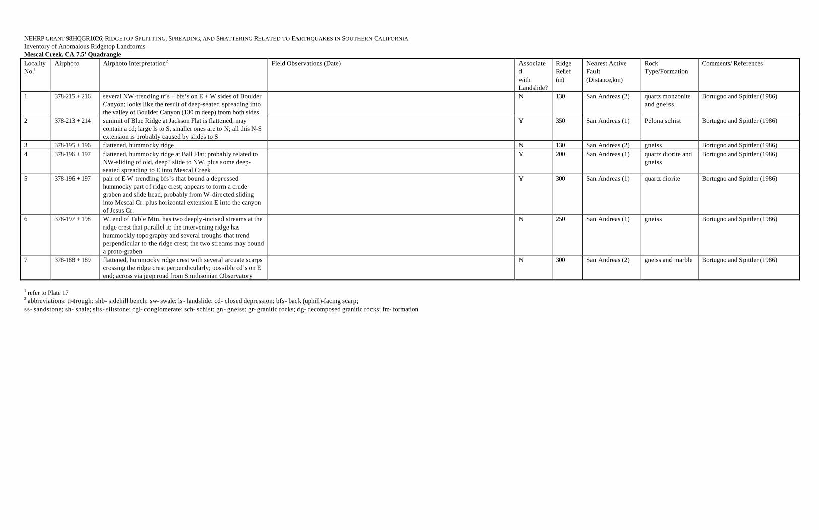
NEHRP GRANT 98HQGR1026; RIDGETOP SPLITTING, SPREADING, AND SHATTERING RELATED TO EARTHQUAKES IN SOUTHERN CALIFORNIA Inventory of Anomalous Ridgetop Landforms Mescal Creek, CA 7.5’ Quadrangle Locality No.1
Airphoto Airphoto Interpretation2 Field Observations (Date) Associated with Landslide?
Ridge Relief (m)
Nearest Active Fault (Distance,km)
Rock Type/Formation
Comments/ References
1 378-215 + 216 several NW-trending tr’s + bfs’s on E + W sides of Boulder Canyon; looks like the result of deep-seated spreading into the valley of Boulder Canyon (130 m deep) from both sides
N 130 San Andreas (2) quartz monzonite and gneiss
Bortugno and Spittler (1986)
2 378-213 + 214 summit of Blue Ridge at Jackson Flat is flattened, may contain a cd; large ls to S, smaller ones are to N; all this N-S extension is probably caused by slides to S
Y 350 San Andreas (1) Pelona schist Bortugno and Spittler (1986)
3 378-195 + 196 flattened, hummocky ridge N 130 San Andreas (2) gneiss Bortugno and Spittler (1986) 4 378-196 + 197 flattened, hummocky ridge at Ball Flat; probably related to
NW-sliding of old, deep? slide to NW, plus some deep-seated spreading to E into Mescal Creek
Y 200 San Andreas (1) quartz diorite and gneiss
Bortugno and Spittler (1986)
5 378-196 + 197 pair of E-W-trending bfs’s that bound a depressed hummocky part of ridge crest; appears to form a crude graben and slide head, probably from W-directed sliding into Mescal Cr. plus horizontal extension E into the canyon of Jesus Cr.
Y 300 San Andreas (1) quartz diorite Bortugno and Spittler (1986)
6 378-197 + 198 W. end of Table Mtn. has two deeply-incised streams at the ridge crest that parallel it; the intervening ridge has hummockly topography and several troughs that trend perpendicular to the ridge crest; the two streams may bound a proto-graben
N 250 San Andreas (1) gneiss Bortugno and Spittler (1986)
7 378-188 + 189 flattened, hummocky ridge crest with several arcuate scarps crossing the ridge crest perpendicularly; possible cd’s on E end; across via jeep road from Smithsonian Observatory
N 300 San Andreas (2) gneiss and marble Bortugno and Spittler (1986)
1 refer to Plate 17 2 abbreviations: tr-trough; shb- sidehill bench; sw- swale; ls - landslide; cd- closed depression; bfs- back (uphill)-facing scarp; ss- sandstone; sh- shale; slts- siltstone; cgl- conglomerate; sch- schist; gn- gneiss; gr- granitic rocks; dg- decomposed granitic rocks; fm- formation

NEHRP GRANT 98HQGR1026; RIDGETOP SPLITTING, SPREADING, AND SHATTERING RELATED TO EARTHQUAKES IN SOUTHERN CALIFORNIA Inventory of Anomalous Ridgetop Landforms Mt. Baldy, CA 7.5’ Quadrangle Locality No.1
Airphoto Airphoto Interpretation2 Field Observations (Date) Associated with Landslide?
Ridge Relief (m)
Nearest Active Fault (Distance,km)
Rock Type/Formation
Comments/ References
1 AXJ-19K-109 to 111
150 m-long uphill-facing scarp near ridgecrest; large ls mass opposite, but lower on ridge
N? 600-700 San Antonio (2), Sierra Madre (7-8)
migmatite or gneiss
Evans et al (1982, USGS Bull. 1506); Bortugno and Spittler (1986) show this feature as a landslide
2 AXJ-19K-113 to 114
large-scale uphill-facing scarps and failed ridge crest; weak troughs at east end; features extend for 1 km along ridge along Sunset Ridge Road; may be the head of a landslide to the N, but there is only 100+ m of relief to the N
Y? 100-300 Sierra Madre (4-5) gneiss Bortugno & Spittler (1986)
3 AXJ-9K-140 to 141
partly failed ridge with eroded tr/shb and swale along Sunset Ridge Road, Sec. 17-T1N-R8W; landslide-associated (?); weak features
Y? 400 Sierra Madre (~2) gneiss or quartz diorite
Bortugno & Spittler (1986)
1 refer to Plate 25 2 abbreviations: tr-trough; shb- sidehill bench; sw- swale; ls - landslide; cd- closed depression; bfs- back (uphill)-facing scarp; ss- sandstone; sh- shale; slts- siltstone; cgl- conglomerate; sch- schist; gn- gneiss; gr- granitic rocks; dg- decomposed granitic rocks; fm- formation

NEHRP GRANT 98HQGR1026; RIDGETOP SPLITTING, SPREADING, AND SHATTERING RELATED TO EARTHQUAKES IN SOUTHERN CALIFORNIA Inventory of Anomalous Ridgetop Landforms Mt. San Antonio, CA 7.5’ Quadrangle Locality No.1
Airphoto Airphoto Interpretation2 Field Observations (Date) Associated with Landslide?
Ridge Relief (m)
Nearest Active Fault (Distance,km)
Rock Type/Formation
Comments/ References
1 378-165 + 166 E-W-trending tr with cd, partly filled with snow on Sept. 21, 1978; several tr + bfs in talus; V. WELL PRESERVED; prob. caused by spreading into 600 m-deep cirque to S
N 400 San Andreas (7) Pelona schist two shb’s reported on N side of ridge between Mt. San Antonio and Mt. Harwood (Morton & Sadler, 1989, p. 314); Morton et al (1989, p. 325) shows this to be the head of a large ls on the S side of the ridge
2 378-165 + 166 v. deep cd at head of apparent slide block ~60 m thick; saddle to S. suggests a fault zone and local crushing of rock
Y 400 San Andreas (8) Pelona schist large cd at head of ls shown by Morton et al (1989, p. 325) on ridge crest 1 km SW of Mt. San Antonio; topo map suggests this is part of a 300-400 m-long trench; locality lies in Wilderness Area
3 WRD photos (partial coverage) 378-185 + 186
mapping of Morton and Sadler (1989) partly verified, but there are probably more landslides in Sec. 18; sag in N ½ Sec. 19 may not be ls -associated
Y & N? 400-700 San Andreas (2) Pelona schist several ridgetop scarps and trenches mapped on Pine Mountain for 4 km both E and W of Wright Mountain; partly ls -associated (Morton & Sadler, 1989, Fig. 13)
4 378-167 + 168 swarm of bfs, shb, and tr on E. end of Pine Mtn. Ridge N? & Y 500-700 San Andreas (4-5) Pelona schist several ridgetop scarps and trough mapped on Pine Mountain Ridge and on crest to west for 2 km by Morton and Sadler (1989, Fig. 13); partly associated with large landslides
5 AXJ-19K-107 to 108
weak, discontinuous, plunging trough on FR with possible cd at W end on Big Horn Ridge; not obviously related to a landslide
N 500 San Antonio (4), San Andreas (11)
quartz diorite? Bortugno & Spittler (1986, State map sheet); locality lies in Wilderness Area
6 378-213 + 214 large, deep cd on ridgecrest, nearly circular cd is 300-400 ft in diameter and 15 ft or more deep; S rim is fractured schist (ps3) with foliation striking N70W and dipping 80 S; large ls scar to SW; cd floor covered with schist fragments, no soil pit dug; possible trench site, good access (24 May 1998)
Y? 900 San Andreas (1.2) Pelona schist Morton & Saddler (1989, p. 318-319, Fig. 13) map a large cd in a rotational ls.
7 378-187 + 188 broad, sloping tr on ridgecrest; no cd N 500 San Andreas (1.5) Pelona schist Bortugno and Spittler (1986) 8 378-212 + 213 hummocky, bench w/poss. Cd but far down below ridge
crest; could be a protalus rampart or slide head Y? 600 San Andreas (6) Pelona schist Bortugno and Spittler (1986)
9 378-202 + 203 tr w/poss. cd just below ridge crest on S. side; narrow end deep
N 500 San Andreas (7) San Andreas (8)
Pelona schist Bortugno and Spittler (1986)
1 refer to Plate 20 2 abbreviations: tr-trough; shb- sidehill bench; sw- swale; ls - landslide; cd- closed depression; bfs- back (uphill)-facing scarp; ss- sandstone; sh- shale; slts- siltstone; cgl- conglomerate; sch- schist; gn- gneiss; gr- granitic rocks; dg- decomposed granitic rocks; fm- formation

NEHRP GRANT 98HQGR1026; RIDGETOP SPLITTING, SPREADING, AND SHATTERING RELATED TO EARTHQUAKES IN SOUTHERN CALIFORNIA Inventory of Anomalous Ridgetop Landforms Mt. Wilson, CA 7.5’ Quadrangle Locality No.1
Airphoto Airphoto Interpretation2 Field Observations (Date) Associated with Landslide?
Ridge Relief (m)
Nearest Active Fault (Distance,km)
Rock Type/Formation
Comments/ References
1 AXJ-16K-88 to 89, 5K-31 to 32
small ridgetop depression, possible cd, large ls to E and S (?) Y 400 Sierra Madre (1.3) quartz diorite Morton (1973, CDMG Spec. Rept. 105) shows a large ls to E
2 AXJ-16K-89 to 90, 84 to 85; 5K-30 to 31
150 m-long trough and uphill-facing scarp on ridgetop, flanked by small landslides and debris flows
Y? 200-400 Sierra Madre (3) quartz diorite Morton (1973) maps as part of a small ls to N
3 AXJ-16K-83 to 84
well-developed ridgetop depression; large ls on N Y? 300+ San Gabriel (2), Sierra Madre (7)
granitic rocks Dibblee (1998) maps ls to N well below ridgecrest
4 AXJ-16K-83 to 84
small elliptical depression on ridgecrest; other than debris flow scars, no ls obvious on S, but possible ls on N
N? 400 San Gabriel (1), Sierra Madre (7.5)
granitic rocks Dibblee (1998) maps no ls
5 AXJ-19K-69 to 71
300 m-long ridgecrest trough; probable ls to W; truncated to S by active debris flows/ls
Y? 200-500 Sierra Madre (1-2) quartz diorite Morton (1973) shows no ls
6 AXJ-16K-48 to 49
flattened, swaley crest of Mt. Wilson with eroded troughs, swales; may be part of immense landslide on N side of ridge
N? ~700 San Gabriel (2), Sierra Madre (5)
quartz diorite Dibblee (1998), maps no ls
1 refer to Plate 14 2 abbreviations: tr-trough; shb- sidehill bench; sw- swale; ls - landslide; cd- closed depression; bfs- back (uphill)-facing scarp; ss- sandstone; sh- shale; slts- siltstone; cgl- conglomerate; sch- schist; gn- gneiss; gr- granitic rocks; dg- decomposed granitic rocks; fm- formation

NEHRP GRANT 98HQGR1026; RIDGETOP SPLITTING, SPREADING, AND SHATTERING RELATED TO EARTHQUAKES IN SOUTHERN CALIFORNIA Inventory of Anomalous Ridgetop Landforms Oat Mountain, CA 7.5’ Quadrangle Locality No.1
Airphoto Airphoto Interpretation2 Field Observations (Date) Associated with Landslide?
Ridge Relief (m)
Nearest Active Fault (Distance,km)
Rock Type/Formation
Comments/ References
1 AAS 187-189; AXJ-3K-101 to 103; NASA 386-387
flattened ridgecrest with swales; partly graded; no obvious landslides associated; possible crack zone (NASA 1994)
N 150 Santa Susana (2) Towsley Fm. ss Dibblee (1992) shows no ls
2 AXJ-3K-101 to 102; AAS 187-188
linear trough, partly the head of a landslide Y 75 Santa Susana (2) Saugus Fm., cgl and ss
Dibblee (1992) show no ls
3 AAS 188-189, 204-205
two small troughs with cd’s and nearby swales on ridgetop; no clear ls association although possible dissected ls on S side of ridge
Y? 150-200 Santa Susana (2.5) Towsley Fm. ss Dibblee (1992) shows no ls
4 AAS 192-193 broad trough and back-facing scarp; possible ls head Y? 200-500 Santa Susana (1.8) Towsley Fm. ss/sh Dibblee (1992) shows no ls 5 AAS 205-206;
NASA 266-267 large depressions on nose of ridge; looks like part of large landslide on Mission Point; no evidence of reactivation or cracks in 1994 except for possible soil shattering locally
Y 250-300 Santa Susana (1) Monterey Fm. sil. sh
Dibblee (1992) shows ls for two upper cd’s only
NOTE: Many landslides in soft sedimentary rocks (Saugus, Pico, Towsley, Sisquoc, Monterey Fms.) in this quad, some of which start at ridgcrest; most not mapped. 1 refer to Plate 8 2 abbreviations: tr-trough; shb- sidehill bench; sw- swale; ls - landslide; cd- closed depression; bfs- back (uphill)-facing scarp; ss- sandstone; sh- shale; slts- siltstone; cgl- conglomerate; sch- schist; gn- gneiss; gr- granitic rocks; dg- decomposed granitic rocks; fm- formation
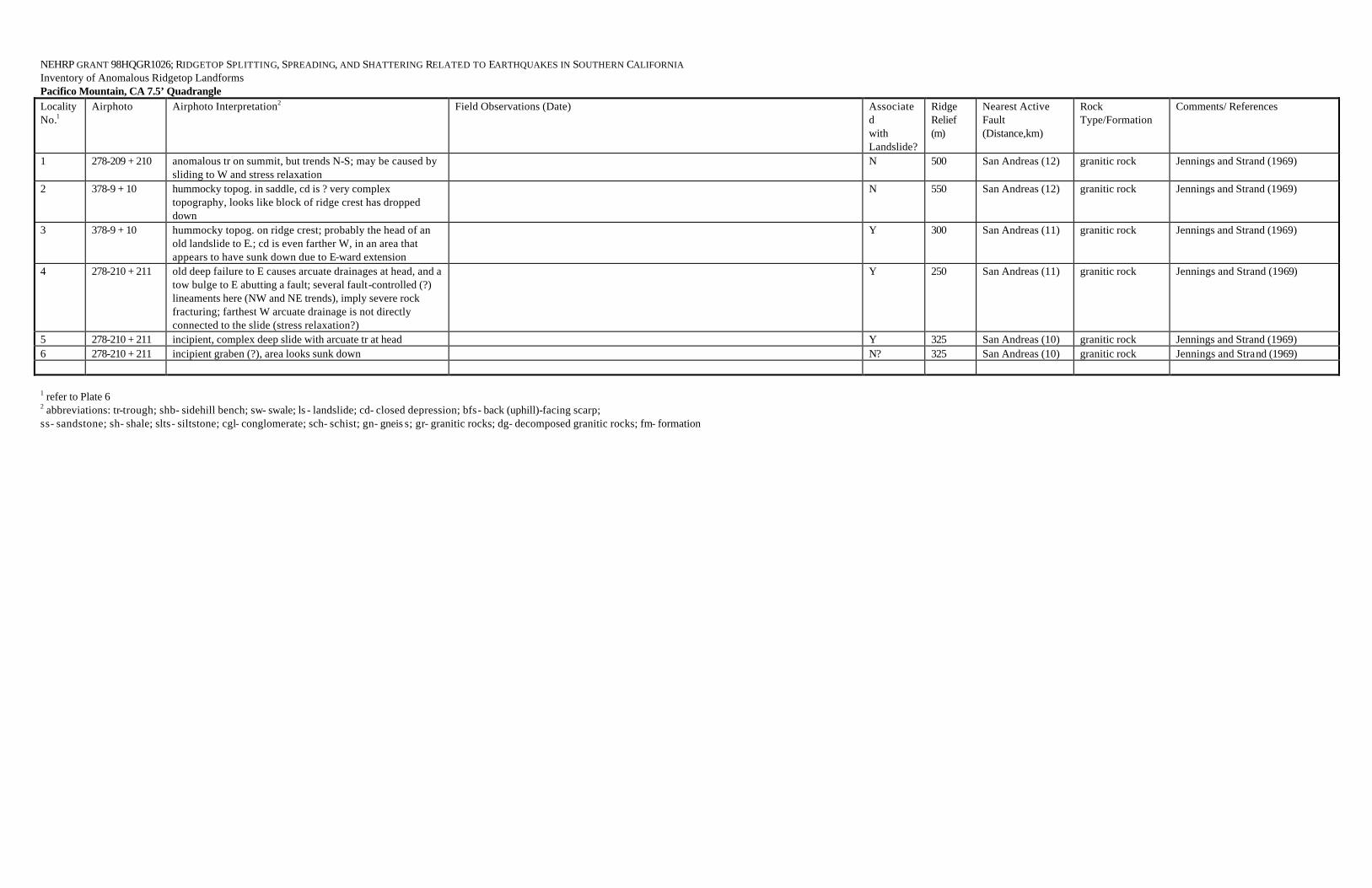
NEHRP GRANT 98HQGR1026; RIDGETOP SPLITTING, SPREADING, AND SHATTERING RELATED TO EARTHQUAKES IN SOUTHERN CALIFORNIA Inventory of Anomalous Ridgetop Landforms Pacifico Mountain, CA 7.5’ Quadrangle Locality No.1
Airphoto Airphoto Interpretation2 Field Observations (Date) Associated with Landslide?
Ridge Relief (m)
Nearest Active Fault (Distance,km)
Rock Type/Formation
Comments/ References
1 278-209 + 210 anomalous tr on summit, but trends N-S; may be caused by sliding to W and stress relaxation
N 500 San Andreas (12) granitic rock Jennings and Strand (1969)
2 378-9 + 10 hummocky topog. in saddle, cd is ? very complex topography, looks like block of ridge crest has dropped down
N 550 San Andreas (12) granitic rock Jennings and Strand (1969)
3 378-9 + 10 hummocky topog. on ridge crest; probably the head of an old landslide to E.; cd is even farther W, in an area that appears to have sunk down due to E-ward extension
Y 300 San Andreas (11) granitic rock Jennings and Strand (1969)
4 278-210 + 211 old deep failure to E causes arcuate drainages at head, and a tow bulge to E abutting a fault; several fault-controlled (?) lineaments here (NW and NE trends), imply severe rock fracturing; farthest W arcuate drainage is not directly connected to the slide (stress relaxation?)
Y 250 San Andreas (11) granitic rock Jennings and Strand (1969)
5 278-210 + 211 incipient, complex deep slide with arcuate tr at head Y 325 San Andreas (10) granitic rock Jennings and Strand (1969) 6 278-210 + 211 incipient graben (?), area looks sunk down N? 325 San Andreas (10) granitic rock Jennings and Strand (1969) 1 refer to Plate 6 2 abbreviations: tr-trough; shb- sidehill bench; sw- swale; ls - landslide; cd- closed depression; bfs- back (uphill)-facing scarp; ss- sandstone; sh- shale; slts- siltstone; cgl- conglomerate; sch- schist; gn- gneis s; gr- granitic rocks; dg- decomposed granitic rocks; fm- formation

NEHRP GRANT 98HQGR1026; RIDGETOP SPLITTING, SPREADING, AND SHATTERING RELATED TO EARTHQUAKES IN SOUTHERN CALIFORNIA Inventory of Anomalous Ridgetop Landforms Pasadena, CA 7.5’ Quadrangle Locality No.1
Airphoto Airphoto Interpretation2 Field Observations (Date) Associated with Landslide?
Ridge Relief (m)
Nearest Active Fault (Distance,km)
Rock Type/Formation
Comments/ References
1 EUX-9-39 to 40, 12-6 to 7; AXJ-16K-3 to 4
flattened, swaley ridge crest and back-facing scarp, about 200 m long; no obvious ls associated
N 200-250 Sierra Madre (3) granitic rocks Dibblee (1989)
2 EUX-12-2 to 4; AXJ-15K-124 to 125
broad swale with cd’s; GOOD TRENCH SITE; no ls observed on photos
Loc. 2—broad swaley ridge; N swale has cd at E end, which is partly bisected by dirt road (fill), POSSIBLE TRENCH SITE; SE edge of cd is well-developed scarp in grd or qtz diorite, N margin is same rock with strong foliation (E-W strike, near vert. dip) and possible shears in road cut (Dibblee shows inferred “Mt. Lukens” fault here); SW swale not checked due to presence of beehives, but may also be closed (20 May 1998)
N 300-400 Mt. Lukens (0-0.2), Sierra Madre/Tujunga (1.3)
granitic rocks Dibblee (1989)
1 refer to Plate 13 2 abbreviations: tr-trough; shb- sidehill bench; sw- swale; ls - landslide; cd- closed depression; bfs- back (uphill)-facing scarp; ss- sandstone; sh- shale; slts- siltstone; cgl- conglomerate; sch- schist; gn- gneiss; gr- granitic rocks; dg- decomposed granitic rocks; fm- formation

NEHRP GRANT 98HQGR1026; RIDGETOP SPLITTING, SPREADING, AND SHATTERING RELATED TO EARTHQUAKES IN SOUTHERN CALIFORNIA Inventory of Anomalous Ridgetop Landforms San Fernando, CA 7.5’ Quadrangle Locality No.1
Airphoto Airphoto Interpretation2 Field Observations (Date) Associated with Landslide?
Ridge Relief (m)
Nearest Active Fault (Distance,km)
Rock Type/Formation
Comments/ References
1 AAS 179-181; AXJ-15K-4 to 6; NASA 350-352 (1/21/94)
weak shb just below ridge crest NW of Kagel Mtn. (Loc. 1b), slightly flattened ridge with weak swale on Kagel Mtn. and ridge to E (Loc. 1a); partly coincides with ruptures reported in 1971 (CDMG Bull. 196); no sags on ridge E of peak where rupture occurred in 1971; N side of mtn covered with landslides well-below ridgecrest, however, activated landslides only mapped on S and W sides of mtn after 1971 quake. 1994 NASA photos show no obvious ruptures after Jan. 1994 earthquake.
Loc. 1a—crest of Kagel Mtn. graded for hang glider launching; sw interpreted on airphotos is a saddle and N-draining swale; 1971 cracks trend at 30 degree angle to Dibblee contact of gn and quartz diorite; ridge to E of Loc. 1a appears flattened, but no well-developed sags; weak shb to NW at Loc. 1b is heavily vegetated with brush, but is partly a N-draining swale held up on the outer (W) edge by a resistant to partly decomposed gneiss (19 May 1998)
N? 300-400 Hospital/Lopez (1); San Fernando (5)
quartz diorite and gneiss (Dibblee, 1991)
Barrows and others (1974 -- CDMG Bull. 196) show nearly continuous cracks with as much as 20 cm down-to-the-N offset in 1971; interpreted as faults and zoned under AP Act; also, only small landslides on S side of ridge. Minor cracks reported on ridge crest in same vicinity after 1994 Northridge EQ (A. Barrows, pers. Comm., 1995); also see Barrows et al (1995, p. 82 and photo 23)
2 AAS 179-180; NASA 351-352
small tr’s and cd on ridgecrest; ls on both sides below crest of ridge; features extends SE into Sunland Quad.
Y 200+ San Gabriel (0.3-0.6), San Fernando (6)
quartz diorite Dibblee (1991); Barrows et al (1974) report no cracks or ls failures in 1971
3 AAS 179-180, 212-213; AXJ-15K-4 to 6, 14K- 146 to 147
NW-facing bfs on partly eroded crest of broad (failed?) ridge; no associated ls evident
N 200-300 Lopez (1), San Fernando (4.5)
Saugus Fm.(cgl and ss) on quartz diorite
Dibblee (1991); Barrows et al (1974) report no cracks or ls failures in 1971
4 AAS 180-182, 172-173; NASA 350-351
small tr or shb, just below arcuate ridgecrest, partly erosional; maybe old ls scar; no 1994 cracks on photos (1/21/94), but road cut below failed
Y? 300 Hospital/Lopez (3), Sylmar/San Fernando (6)
granitic rocks and gneiss
Dibblee (1991)
5 AAS 186-187 failed ridge west of “Fremont 2359’” Bench Mark in Sec. 18; massive landslides with scarps and cd’s at crest
Y 200 Santa Susana/Hospital (2)
Towlsey Fm. ss Dibblee (1991) shows complex structure, stratigraphy, landslide
1 refer to Plate 9 2 abbreviations: tr-trough; shb- sidehill bench; sw- swale; ls - landslide; cd- closed depression; bfs- back (uphill)-facing scarp; ss- sandstone; sh- shale; slts- siltstone; cgl- conglomerate; sch- schist; gn- gneiss; gr- granitic rocks; dg- decomposed granitic rocks; fm- formation
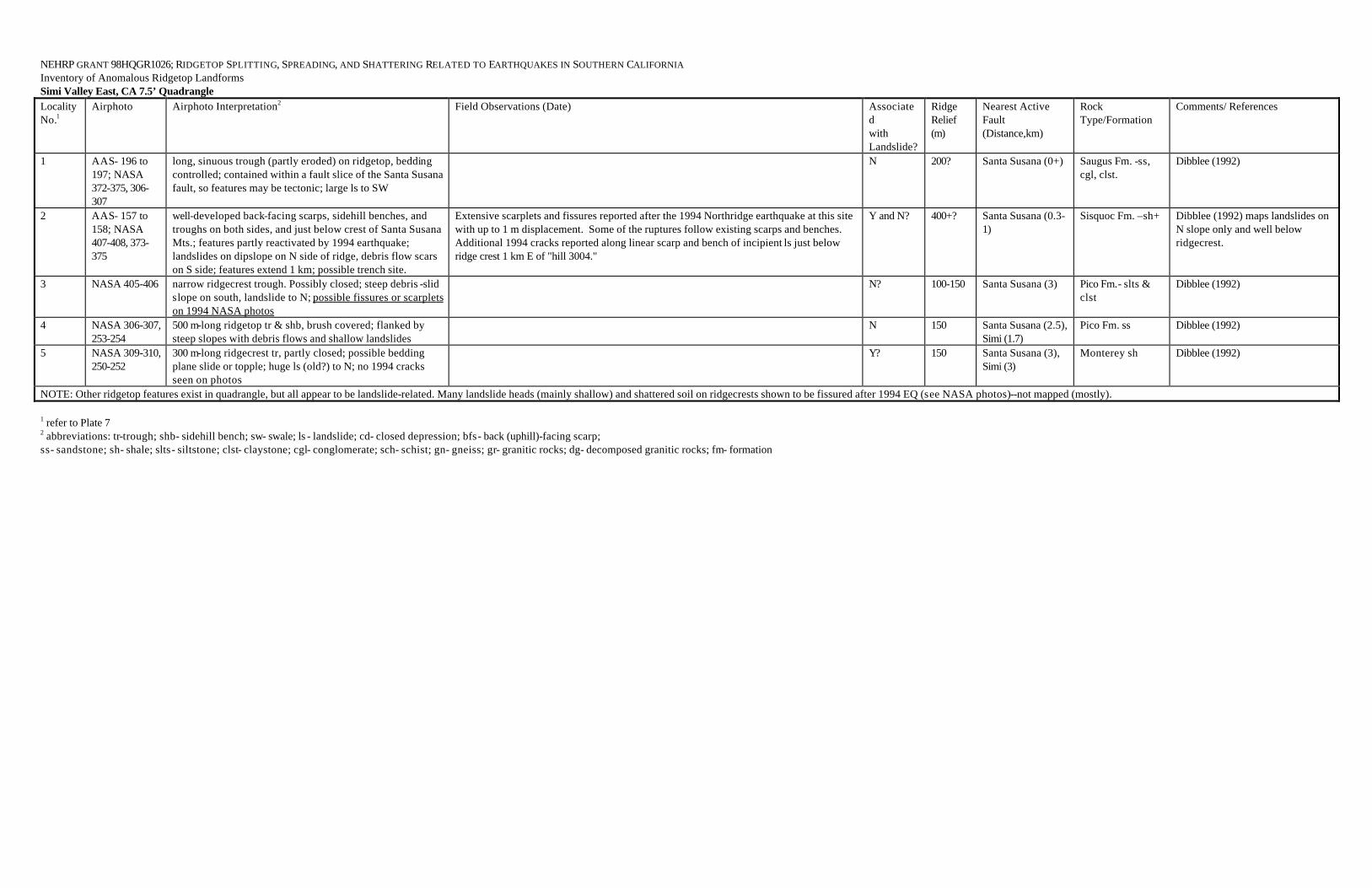
NEHRP GRANT 98HQGR1026; RIDGETOP SPLITTING, SPREADING, AND SHATTERING RELATED TO EARTHQUAKES IN SOUTHERN CALIFORNIA Inventory of Anomalous Ridgetop Landforms Simi Valley East, CA 7.5’ Quadrangle Locality No.1
Airphoto Airphoto Interpretation2 Field Observations (Date) Associated with Landslide?
Ridge Relief (m)
Nearest Active Fault (Distance,km)
Rock Type/Formation
Comments/ References
1 AAS- 196 to 197; NASA 372-375, 306-307
long, sinuous trough (partly eroded) on ridgetop, bedding controlled; contained within a fault slice of the Santa Susana fault, so features may be tectonic; large ls to SW
N 200? Santa Susana (0+) Saugus Fm. -ss, cgl, clst.
Dibblee (1992)
2 AAS- 157 to 158; NASA 407-408, 373-375
well-developed back-facing scarps, sidehill benches, and troughs on both sides, and just below crest of Santa Susana Mts.; features partly reactivated by 1994 earthquake; landslides on dipslope on N side of ridge, debris flow scars on S side; features extend 1 km; possible trench site.
Extensive scarplets and fissures reported after the 1994 Northridge earthquake at this site with up to 1 m displacement. Some of the ruptures follow existing scarps and benches. Additional 1994 cracks reported along linear scarp and bench of incipient ls just below ridge crest 1 km E of "hill 3004."
Y and N? 400+? Santa Susana (0.3-1)
Sisquoc Fm. –sh+ Dibblee (1992) maps landslides on N slope only and well below ridgecrest.
3 NASA 405-406 narrow ridgecrest trough. Possibly closed; steep debris -slid slope on south, landslide to N; possible fissures or scarplets on 1994 NASA photos
N? 100-150 Santa Susana (3) Pico Fm.- slts & clst
Dibblee (1992)
4 NASA 306-307, 253-254
500 m-long ridgetop tr & shb, brush covered; flanked by steep slopes with debris flows and shallow landslides
N 150 Santa Susana (2.5), Simi (1.7)
Pico Fm. ss Dibblee (1992)
5 NASA 309-310, 250-252
300 m-long ridgecrest tr, partly closed; possible bedding plane slide or topple; huge ls (old?) to N; no 1994 cracks seen on photos
Y? 150 Santa Susana (3), Simi (3)
Monterey sh Dibblee (1992)
NOTE: Other ridgetop features exist in quadrangle, but all appear to be landslide-related. Many landslide heads (mainly shallow) and shattered soil on ridgecrests shown to be fissured after 1994 EQ (see NASA photos)--not mapped (mostly). 1 refer to Plate 7 2 abbreviations: tr-trough; shb- sidehill bench; sw- swale; ls - landslide; cd- closed depression; bfs- back (uphill)-facing scarp; ss- sandstone; sh- shale; slts- siltstone; clst- claystone; cgl- conglomerate; sch- schist; gn- gneiss; gr- granitic rocks; dg- decomposed granitic rocks; fm- formation

NEHRP GRANT 98HQGR1026; RIDGETOP SPLITTING, SPREADING, AND SHATTERING RELATED TO EARTHQUAKES IN SOUTHERN CALIFORNIA Inventory of Anomalous Ridgetop Landforms Sunland, CA 7.5’ Quadrangle Locality No.1
Airphoto Airphoto Interpretation2 Field Observations (Date) Associated with Landslide?
Ridge Relief (m)
Nearest Active Fault (Distance,km)
Rock Type/Formation
Comments/ References
1 AXJ-15K-81 to 82
500 m-long eroded trough (probable former uphill-facing scarp) halfway up low ridge; no ls
N 50-75 San Fernando (7), San Gabriel (1)
gneiss and granodiorite
Dibblee (1991)
2 AXJ-15K-77 to 78; C-2878-5 to 7 and 25 to 27
two large ridgetop troughs, the eastern tr with partial closure and ponded alluvium; no associated ls evident
N 200-300 San Fernando/Tujunga (3), San Gabriel (3)
quartz diorite Dibblee (1991); Barrows et al (1974) show no ruptures in 1971.
3 AXJ-7K-104 to 105, 15K-77 to 78, 20K-23 to 24
curvilinear trough along low ridge crest, somewhat eroded; probably a ls head scarp
Y? 200 Tujunga/San Fernando (1)
quartz diorite Dibblee (1991); Barrows et al (1974) show no 1971 ruptures.
4 AXJ-7K-104 to 106, 15K-77 to 78
100 m-long arcuate trough with cd on ridge crest; probable ls head scarp
Y 125 Tujunga/San Fernando (0.6)
quartz diorite Dibblee (1991) shows Rowley fault zone about 50 m to SW; Barrows et al (1974) show no 1971 failures
5 AXJ-15K-72 to 74
anomalous drainages associated with eroded troughs and uphill-facing scarps; possible large-scale landsliding to crest of Yerba Buena Ridge
Y? 700 San Fernando (3), Sunland (1)
quartz diorite Dibblee (1991) show no ls or other recognition of features; 1971 ruptures (Barrows et al, 1974) on anomalous ridge in SW ¼ Sec. 16 show no evidence of pre-existing geomorphic features on 1954 photos
6 AXJ-15K-28 to 29, 20K-33 to 34
small trough with cd just below ridge crest; apparent ls feature
Y 125 San Fernando (1) Towsley Fm. cgl Dibblee (1991)
7 AXJ-15K-28 to 29
broad tr bounded by scarp to S on flattened ridgetop; feature is weak; possibly ls -associated; tr partly coincides with 1971 ruptures.
N? 200 San Fernando (1) Towlsey Fm. cgl Dibblee (1991); several short 1971 ruptures with 5-15 cm down-to-the-north offset mapped by Barrows et al (1974)
8 AAS 178-180; AXJ-15K-30 to 32; NASA 352-353
Loc. a-- sidehill bench/trough just below ridge crest; apparent head of ls; failed ridge crest (with cd) extends 1 km to W (Loc. b)
Loc. 8a—tr/shb drains to E, W end is breached by 2 drainages, central and E parts not visited (18 May 1998) Loc. 8b—400 ft-long tr with cd at E end, est. 5-6 ft of closure; tr 100+ ft to N and downslope not visited; gneiss exposure between 2 tr’s shows foliation striking N30W and dip 55 SW, with joints striking N60E, vertical; GOOD TRENCH SITE (19 May 1998)
Y? 200 San Gabriel (1), San Fernando (6)
quartz diorite and gneiss
Dibblee (1991)
1 refer to Plate 10 2 abbreviations: tr-trough; shb- sidehill bench; sw- swale; ls - landslide; cd- closed depression; bfs- back (uphill)-facing scarp; ss- sandstone; sh- shale; slts- siltstone; cgl- conglomerate; sch- schist; gn- gneiss; gr- granitic rocks; dg- decomposed granitic rocks; fm- formation

NEHRP GRANT 98HQGR1026; RIDGETOP SPLITTING, SPREADING, AND SHATTERING RELATED TO EARTHQUAKES IN SOUTHERN CALIFORNIA Inventory of Anomalous Ridgetop Landforms Telegraph Peak, CA 7.5’ Quadrangle Locality No.1
Airphoto Airphoto Interpretation2 Field Observations (Date) Associated with Landslide?
Ridge Relief (m)
Nearest Active Fault (Distance,km)
Rock Type/Formation
Comments/ References
1a WRD 5253-5254
large uphill-facing scarp of Morton et al (1991) verified; although the scarp occurs 125 m below ridge top, it is arcuate and looks like head of ls; at least three cd’s. Photo coverage incomplete, but large displacement to NE (>10 m?). No large ls observed on SW side or ridge, no photo coverage to NE. Mapping of Morton et al slightly revised
N? 200 to S, 300 to N
San Andreas (2) Pelona schist Morton et al (1991) show large ls deposits to E of 5080’ peak, but none to W ans S, and no direct association of scarp with ls
1b WRD 882-883 weak bfs weak bfs appears to have ponded sediment in schist; probably not a good trench site (23 May 1998)
Y 300 San Andreas (1) Pelona schis t Morton et al (1991) map as ls scarp
1c WRD 882-883 well-developed ridgecrest tr with possible cd’s tr on spur NE of road verified but two cd’s at NE end not quite closed; soil pit to 1 ft has fine-med sand and gravel, young (no clay films); cd just N of road is closed but partly graded; soil pit to 1 ft mostly sand (cumulic young soil?), possible trench site; no cd W of road; shb at W end not closed and is actually 2 shb’s 60-80 ft apart; fragments of slabby schist cover ground; main ridge is flattened to slightly hummocky (possibly due to distributive fissuring) (23 May 1998)
Y 350-400 San Andreas (1-1.5)
Pelona schist Morton et al (1991) map mostly as ls scarps
1d WRD 883-884 trough and scarps, hummocky ridge crest Y 300 San Andreas (1.3) Pelona schis t Morton et al (1991) map partly as ls.
1e WRD 884-885 hummocky ridge crest with possible cd’s; probable landslides on flanks; weak, narrow tr on ridge to NW
narrow rocky tr, no soil, nearly closed at W end; to SE is a broad, hummocky sw or tr on ridgecrest with small shallow cd above (23 May 1998)
Y 250-300 San Andreas (1.3) Pelona schist Morton et al (1991) map as ls
1f WRD 885-886 well-developed troughs on crests of two spurs as well as on main ridge
two small depressions at W end of ridge crest are nearly closed, but have thin soil; other features not checked due to heavy brush (23 May 1998)
Y 70-100 San Andreas (1) Pelona schist Morton et al (1991) map mostly as ls
1g WRD 886-887 well-developed tr with cd on spur Y 200 San Andreas (1) Pelona schist Morton et al (1991) map as ls scarp 1h WRD 886-887 broad tr with cd on ridge crest; tr’s on peak to W cd with 1-2 m closure in broad tr; some ponded water, but partly graded and drained;
possible trench site (23 May 1998) Y 400 San Andreas (1.5) Pelona schist Morton et al (1991) map as ls scarp
1i WRD 889-890 ridgecrest tr with possible closure; possible ls on SE side of ridge (hummocky, rocky)
Y? 300 San Andreas (1) Pelona schist Morton et al (1991) show large ls adjacent on SE side of ridge
1j WRD 888-889 well-developed bfs’s with cd’s on peak 6966 ft, subparallel to ls scarp to N; other ridgetop scarps to E
Y? 300 San Andreas (1.6) Pelona schist Morton et al (1991) do not map landslide mass, only scarps
2a WRD 5251-5252, AXL-35K-121 to 122, 82 to 83
400 m-long bfs with probable cd (brushy vegetation); other than debris flows on opposite (S) side of ridge, no ls seen on airphotos
N 200 San Jacinto (1?), San Andreas (4)
fractured Tertiary granodiorite
Morton et al (1991) mapped this scarp but show no landslide
2b WRD 5252-5254; AXL-35K-121 to 122
300 m-long set of bfs’s near top of ridge, possible cd; no ls observed; mapping similar to Morton et al (1991)
N 300 San Jacinto (1?), San Andreas (4)
contact between granodiorite and Pelona schist
Morton et al (1991) do not map landslide deposits
3a WRD 800-802 linear tr with no visible sediment, no cd (?); other weak tr’s associated; not landslide-associated
N? 200-250 San Andreas (0.7) gneiss Morton et al (1991) show no landslides here
3b WRD 801-803 linear tr’s and bfs’s; partly graded and weak; possible cd’s S-facing scarp and tr verified at NW end, but no cd; only partly checked due to fog and poor visibility, brushy, ridgecrest graded; discontinuous outcrops of marble with gn and gr (25 May 1998)
Y 200-250 San Andreas (0.9) gneiss Morton et al (1991) maps this as the head of a ls, in part
3c WRD 803-805 well-developed tr’s and bfs with cd’s; old landslide remnant to N (?)
weak tr with cd (?) at W end; gn and marble outcrops with foliation strike of N75W, S dip on hill 5549 ft; other features not verified in fog (25 May 1998)
Y? 250 San Andreas (1) gneiss Similar mapping to Morton et al (1991), who map this as the head of a ls
Telegraph Peak, CA 7.5’ Quadrangle (continued)

3d WRD 804-805 cd at W end of tr/bfs; hummocky ridge to W; tr with cd NW of hill 5938 ft
tr W of hill 5938 ft verified; scarps on hill 5938 ft not checked; cd at W end of S-facing scarp just E of hill 5938 ft has slight closure, but possibly modified by grading (firebreak); gneissic debris; foggy, poor visibility (25 May 1998)
N? 275 San Andreas (0.9) gneiss & ls tr W of hill 5938 ft mapped as N-facing scarp by Morton et al (1991), but not part of nearby ls
3e WRD 805-806 broad hummocky tr across saddle in ridge, cd’s; W-facing scarp to W
did not examine—foggy, steep, brushy N 400 San Andreas (1.3) gneiss Morton et al (1991)
3f WRD 805-806 well-developed ridgecrest tr’s with possible cd’s tr just N of ridgecrest is more of a shb with little if any closure and modified by grading (firebreak?); soil pit at W end has dark, organic carbonaceous soil with gneissic rock clasts to 1-1.2 ft deep, then a big rock; longer tr to S on ridgecrest also not closed, same gneissic rocky soil; foggy (25 May 1998)
Y
300-400
San Andreas (1.3)
gneiss
features coincide with ls margin of Morton et al (1991)
3g WRD 806-807 weak ridgecrest tr ridgecrest tr coincides with Morton et al’s scarp; possible cd with carbonaceous rocky (granitic, gneissic fragments) soil; low outcrops of marble and gneiss nearby (no attitudes measured) (25 May 1998)
Y? 400 San Andreas (1) gneiss + Morton et al (1991) map scarp above ls deposit
3h WRD 806-807 arcuate bench, looks like head of a ls; tr with possible cd’s shb with flat areas at W end, not quite closed; thin, carbonaceous, loose, granular rocky soil; flat area is approx. 100 ft by 400 ft; light colored, foliated granitic rock or gneiss exposed on ridge above) (25 May 1998)
Y 400 San Andreas (1) ls in gneiss Morton et al (1991) map as a ls
4 378-155 to 156 large sinuous tr and scarp extends 1 km along ridgecrest (Morton and Sadler, 1989); lower (eastern) 0.5 km is occupied by a ski run of the Mt. Baldy Ski Area; edges of run appear to have been cut by machinery; GOOD TRENCH SITE IF SURFACE HAS NOT BEEN SCALPED BY MACHINERY
N? 400-500 San Andreas (7) Pelona schist Morton et al. (1991); small landslide only partly associated
1 refer to Plate 21 2 abbreviations: tr-trough; shb- sidehill bench; sw- swale; ls - landslide; cd- closed depression; bfs- back (uphill)-facing scarp; ss- sandstone; sh- shale; slts- siltstone; cgl- conglomerate; sch- schist; gn- gneiss; gr- granitic rocks; dg- decomposed granitic rocks; fm- formation

NEHRP GRANT 98HQGR1026; RIDGETOP SPLITTING, SPREADING, AND SHATTERING RELATED TO EARTHQUAKES IN SOUTHERN CALIFORNIA Inventory of Anomalous Ridgetop Landforms Val Verde, CA 7.5’ Quadrangle Locality No.1
Airphoto Airphoto Interpretation2 Field Observations (Date) Associated with Landslide?
Ridge Relief (m)
Nearest Active Fault (Distance,km)
Rock Type/Formation
Comments/ References
1 AAS-158 to 159; NASA 478-479
small trough or shb just below ridgecrest; possible head of ls on dipslope. No cracks on NASA photos
Y? 200 Santa Susana (3-4) Pico Fm.- clst, slts, ss
Dibblee (1993) does not show a landslide here
2 AAS-156 to 157; NASA 512-513
low ridge with back-facing scarps with large tr/cd below; possible slump block; 1994 NASA photos show no cracks along scarp or troughs, only minor debris flows on slopes to N; TRENCHABLE; adjacent to Santa Clara River
Y? 50-80 Santa Susana (5-6) Pico Fm. ss Dibblee (1993) shows no ls
3 AAS-110 to 111; AXI-3K-22 to 23; NASA 706 to 708
series of troughs, closed depressions and uphill-facing scarps along ridgecrest for 1.9 km; landslides flank both sides of ridge; SEVERAL TRENCHABLE SITES; the Ramona oilfield ls failed in 1994 EQ (Harp & Jibson, 1996)
Loc. 3a—cd in saddle at W end has minor closure Loc. 3b—cd mapped from airphotos is not closed, but is a SE-plunging tr Loc. 3c—3-4 m-deep cd appears to be artificial, with earthfill dam on the E Loc. 3d—long, deep sinuous cd probably is the head of a large ls that may include the Ramona Oilfield ls that failed in 1994; only viewed from a distance; POSSIBLE TRENCH SITE; (28 May 1998)
Y 100-200 Holzer (0.2-0.3), San Gabriel (8)
Pico Fm. clst-slts Dibblee (1993); Barrows (1986, CDMG OFR 86-9) shows some of ridge features to NE to be part of ls complex
4 AAS-112 to 113; AXI-2K-47 to 48; NASA 709-711
800 m-long zone of deep troughs and uphill-facing scarps with closed depressions on ridge crests; gradational with large ls complex on S (dip-slope) side of ridge; VERY TRENCHABLE
Y 200-300 Holzer (1.7), San Gabriel (10)
Hasley Cgl. Member of Towsley Fm.
Dibblee (1993)
5 AXI-9K-28 to 29; NASA 471-473
several broad troughs, one with a cd, along ridgecrest for 1 km; one small ls mapped; ridge crest appears flattened. No cracks seen on 1994 NASA photos, but shallow debris flows triggered on flanks of ridge
N 200-250 Oakridge (1.5) Towsley Fm., steeply-dipping ss
Dibblee (1993) shows no slides
6 AXI-11K-75 to 76; NASA 667-669
series of south (uphill)-facing scarps and two cd’s occur along ridgecrest for 1.7 km, appear to be controlled by steep bedding along this strike ridge; flanked by large landslides on south, one of which (Rancho Camulos slide) was reactivated in 1994; 1994 cracks also reported on ridges (spurs?) adjacent to slide (Harp & Jibson, 1996); not clear from NASA photos if ridgecrest troughs were reactivated in 1994
Y? 200-300 Holser (1), Oakridge (13)
Pico Fm., clst-slts Dibblee (1993) shows slides; Harp & Jibson (1996) show 1994 slides
7 AAS-114 to 115; AXI-2K-44 to 45; NASA 670 to 672 and 601 to 602
sharply defined ridgecrest trough about 350 m long, controlled by bedding; locally closed; also uphill-facing scarp on N side of peak; not part of a landslide, but slides below
N? 200+ Oakridge (2.7), Del Valle (0.4), Holser (2)
Pico Fm. clst & slts
Dibblee (1993) shows no landslide; dip is 32-37S

Val Verde, CA 7.5’ Quadrangle (continued) 8 AXI-3K-20 to
22; AAS-114 to 116; NASA 671 to 673 and 600 to 602
arcuate set of well-developed grabens, some closed; appears to be part of a remnant landslide that moved downdip to S (a on map); ls is truncated on each side by arcuate ls scars that are younger (b and c on map); features reportedly did not reactivate in 1994 EQ although adjacent slide c did (McCrink, 1995), the latter enlarging to include ridgecrest (d). The cd in the bfs at a may be worth trenching to validate recent and past movements. Other ridgetop tr’s also occur to the east at f and g on the same ridge and appear to be heads of landslides
Loc. 8a—main arcuate tr with associated cd’s are deep and well-developed; cd under “k” in “water tank” on map is slightly closed, shallow soil pit had young soil and did not reveal any 1994 fissures (which is consistent with McCrink’s observations); cd 500 ft to W is better developed with ~3.6 m of closure across area 40 x 25 m (est.) flanked by N-facing arcuate scarp, it also has a 0.5 m-deep graben in front of scarp, which may suggest a recent fissuring event; no soil pit; nearby rock is Pico slts-clst. Good trench site at head of old ls (see map). Field checked 28 May 1998.
Y 200-300 Holser (2), Del Valle (0.5), Oak Ridge (3)
Pico Fm. slts-clst Dibblee (1993); McCrink (1995) reports road in upper part of ls d-c to be offset 12 m laterally and 6 m vertically, but there was no reactivation of ls at a; McCrink also suggests greater movement in upper part of d-c than lower part, which is consistent with EQ-triggered movements at Loma Prieta where the toes of slides showed very little displacement (Spittler and Harp, 1990). Also, see San Martinez Grande slide of Harp and Jibson (1996)
9 AAS-58 to 59; NASA 811 to 812
broad shallow tr along ridge crest with possible cd; partly flanked by, but not part of, small landslides; no reactivation seen on NASA (1994) photos. Ridgetop tr’s to W are landslide-associated
N? 200 Holser (5) Hasley Cgl. Member of Towsley Fm. over Sisquoc Fm. sh
Dibblee (1993), shows only one landslide
10 AAS-62 to 64; NASA 707 to 708
narrow trough with 2 closed depressions on ridgecrest; marginal to a landslide; no apparent reactivation in 1994
Y 150 Holser (1.3) Pico Fm.- contact between ss and clst-slts
Dibblee (1993), shows no landslides
11 AAS-55 to 56; NASA 808-809
ridge shattered for length of hundreds of meters beyond margins of Loma Verde ls, which was triggered by 1994 EQ (Harp & Jibson, 1996); part of slide mappable on 1980 photos (Barrows, 1986), but no ridgetop features seen on NASA photos other than probable fissures & scarps marginal to the activated 1994 landslide
Y 125-150 Holser (5) Pico Fm. ss Harp & Jibson (1996, p. S326); Barrows (1986); Dibblee (1993)
12 AAS 108-109; NASA 674 to 676
broad hummocky troughs with cd at E end; not flanked by apparent landslides; could be an incipient slide. NASA photos 674-676 show that 200 m segment of ridgecrest failed in 1994, dislocating crest 100 m to S and downslope and creating new and sharper crest about 20-30 m farther to N. This may be an examp le of a single reactivation of a previously-failed ridge
N? 150 Holser (0.8) Pico Fm. ss Dibblee (1993) shows no ls; Harp & Jibson (1996, pl. 1) verify 1994 slide
1 refer to Plate 3 2 abbreviations: tr-trough; shb- sidehill bench; sw- swale; ls - landslide; cd- closed depression; bfs- back (uphill)-facing scarp; ss- sandstone; sh- shale; slts- siltstone; cgl- conglomerate; sch- schist; gn- gneiss; gr- granitic rocks; dg- decomposed granitic rocks; fm- formation

NEHRP GRANT 98HQGR1026; RIDGETOP SPLITTING, SPREADING, AND SHATTERING RELATED TO EARTHQUAKES IN SOUTHERN CALIFORNIA Inventory of Anomalous Ridgetop Landforms Valyermo, CA 7.5’ Quadrangle Locality No.1
Airphoto Airphoto Interpretation2 Field Observations (Date) Associated with Landslide?
Ridge Relief (m)
Nearest Active Fault (Distance,km)
Rock Type/Formation
Comments/ References
1 478-27 + 28 E-W trending graben at summit, generally parallel but not coincident with two short faults mapped by Noble (1954); broad portions of ridge crest are hummocky
N 350 San Andreas (0.8) San Francisquito Fm. (massive ss)
Noble (1954), stratigraphic terminology from Bortugno and Spittler (1986)
2 478-28 + 29 sloping tr’s and sharp graben on low-relief ridges in crush zone of Noble (1954) between the San Jacinto fault and the Punchbowl fault
N 100 San Andreas (4) on Punchbowl fault between Punchbowl Fm. (ss) and quartz diorite
Noble (1954) ), stratigraphic terminology from Bortugno and Spittler (1986)
1 refer to Plate 16 2 abbreviations: tr-trough; shb- sidehill bench; sw- swale; ls - landslide; cd- closed depression; bfs- back (uphill)-facing scarp; ss- sandstone; sh- shale; slts- siltstone; cgl- conglomerate; sch- schist; gn- gneiss; gr- granitic rocks; dg- decomposed granitic rocks; fm- formation

NEHRP GRANT 98HQGR1026; RIDGETOP SPLITTING, SPREADING, AND SHATTERING RELATED TO EARTHQUAKES IN SOUTHERN CALIFORNIA Inventory of Anomalous Ridgetop Landforms Waterman Mountain, CA 7.5’ Quadrangle Locality No.1
Airphoto Airphoto Interpretation2 Field Observations (Date) Associated with Landslide?
Ridge Relief (m)
Nearest Active Fault (Distance,km)
Rock Type/Formation
Comments/ References
1 378-33 + 34 sharp linear ridgetop trough at Camp Cumorah Crest in main (south) trough, steep sideslopes are covered with grus, actively ravelling; there is no flat area at the bottom of the trough; the stream is trickling N at a low gradient; in one place apparently intact, unfractured (!) granite is exposed in the stream bottom; in N trough, water is also running; fact that water is flowing in both troughs suggests that bedrock is shallow, groundwater is forced to the surface, and open fractures do not exist; NO TRENCHABLE SITES
Y? 150 San Andreas (14) granitic rocks Bortugno and Spittler (1986)
1a 378-33 + 34 poorly defined trough at ridgetop N 250 San Andreas (13) granitic rocks Bortugno and Spittler (1986) 2 378-33 + 34 3 troughs trending perpendicular to ridge node; N-most,
arcuate trough is above slide headscarp; other 2 troughs are linear, contain cd’s, probably caused by slide unloading
Y 130 San Andreas (14) granitic rocks Bortugno and Spittler (1986)
3 378-32 + 33 2 troughs, each defines the head of a drainage that turns perpendicular to slope near the ridgecrest; probably represent headscarp pull-aparts
Y 175 San Andreas (16) Mt. Lowe granodiorite
Bortugno and Spittler (1986)
4 378-31 + 32 large complex of shallow + deep landsliding; isolated summit 4915’ appears to have moved to the NW into Devils Canyon; cd behind summit is blocked by slide or debris -flow lobe, but also coincides with NE-trending lineament
Y 300 San Andreas (16) landslide in granitic rocks
Bortugno and Spittler (1986)
5 378-52 + 53 series of E-W-trending tr’s and structurally-controlled drainages at summit of Waterman Mtn; good access via road to ski area; some troughs are in ski runs!; cd directly S of top lift terminal; GOOD TRENCH SPOT
N 400 San Andreas (12) granitic rocks Bortugno and Spittler (1986)
6 378-54 + 55 old, degraded tr’s and benches assoc. with old slide Y 500 San Andreas (16) granitic rocks and landslide
Bortugno and Spittler (1986)
7 378-38 + 39 scarps associated with slides Y 550 San Andreas (13) Lowe granodiorite Bortugno and Spittler (1986) 7a 378-38 + 39 linear gullies and bfs, all probably erosional; most are not
parallel to ridge crest N 200 San Andreas (13) Lowe granodiorite Bortugno and Spittler (1986)
1 refer to Plate 18 2 abbreviations: tr-trough; shb- sidehill bench; sw- swale; ls - landslide; cd- closed depression; bfs- back (uphill)-facing scarp; ss- sandstone; sh- shale; slts- siltstone; cgl- conglomerate; sch- schist; gn- gneiss; gr- granitic rocks; dg- decomposed granitic rocks; fm- formation

Plate 1. INDEX MAP OF ANOMALOUS RIDGETOP LANDFORMSLos Angeles 30' by 60' QuadrangleAccompanies Ridgetop Spreading Features and Relationship to Earthquakes, San Gabriel Mountains Region, Southern California --Part A: Distribution and Description of Ridgetop Depressions (Sackungen)
NOTES: 1) Only numbered (significant) sites of anomalous landforms are shown on this Index Map. Additional landforms are shown on 1:24,000-scale Field Sheets, Plates 3-27. 2) Numbers refer to site numbers in Tables 3 and 4, Plates 3-27, and Appendix. Circled numbers indicate sites where landforms are not associated with landslides (landslide association classes N and N?). 3) Line symbols are schematic and only represent the general location and orientation of landforms.Troughs and other depressions are indicated by "railroad track" symbol and tickmarks on scarps are shown by tick marks on the down side.
Plate 3 Plate 4 Plate 5 Plate 6
Plate 12Plate 11Plate 10Plate 9Plate 8Plate 7
Plate 13 Plate 14
PLATE 1

Plate 2. INDEX MAP OF ANOMALOUS RIDGETOP LANDFORMSSan Bernardino 30' by 60' QuadrangleAccompanies Ridgetop Spreading Features and Relationship to Earthquakes, San Gabriel Mountains Region, Southern California --Part A: Distribution and Description of Ridgetop Depressions (Sackungen)
NOTES: 1) Only numbered (significant) sites of anomalous landforms are shown on this Index Map. Additional landforms are shown on 1:24,000-scale Field Sheets, Plates 3-27. 2) Numbers refer to site numbers in Tables 3 and 4, Plates 3-27, and Appendix. Circled numbers indicate sites where landforms are not associated with landslides (landslide association classes N and N?). 3)Line symbols are schematic and only represent the general location and orientation of landforms.Troughs and other depressions are indicated by "railroad track" symbol and tickmarks on scarps are shown by tick marks on the down side.
Plate 26
Plate 15 Plate 16 Plate 17
Plate 18 Plate 19 Plate 20 Plate 21 Plate 22
Plate 23 Plate 24 Plate 25 Plate 27