rift flank uplift and landscape evolution of hall...
TRANSCRIPT

Rift flank uplift and landscape evolution of Hall Peninsula, Baffin Island,Nunavut: an exhumation model based on low-temperaturethermochronology
C.G. Creason, Department of Earth Science, Dalhousie University, Halifax, Nova Scotia,
J.C. Gosse, Department of Earth Science, Dalhousie University, Halifax, Nova Scotia
M.D. Young, Department of Earth Science, Dalhousie University, Halifax, Nova Scotia
Creason C.G., Gosse, J.C. and Young, M.D. 2013: Rift flank uplift and landscape evolution of Hall Peninsula, Baffin Island, Nunavut: anexhumation model based on low-temperature thermochronology; in Summary of Activities 2012, Canada-Nunavut Geoscience Office, p.75–84.
Abstract
This study is part of the Canada-Nunavut Geoscience Office’s Hall Peninsula Integrated Geoscience Program, a multiyearbedrock and surficial geology mapping program with associated thematic studies. Baffin Island is characterized by fault-line bounded physiographic provinces that reflect lithological and structural elements inherited over the past two billionyears. The northern coast of the Hall Peninsula half-horst is a rugged highland that constitutes a portion of the eastern ArcticRim, a mountain range extending from northern Labrador to southern Ellesmere Island. Although Quaternary ice sheet andalpine glacial erosion has increased the relief of the mountain range, it appears from thermochronology and marine stratig-raphy that much of the relief was generated by incision through isostatically and thermally uplifted lithosphere accompany-ing rifting from Greenland. In the past decade, offshore geophysical surveys have provided a firmer understanding of post-rift processes and the nature of the continental-ocean crust boundary in Baffin Bay and Davis Strait. However, many funda-mental questions remain regarding the exhumation history of Hall Peninsula and adjoining provinces and the subsequentsediment fluxes to the margin: What is the timing of initial rifting along the Arctic Rim and which rifting models does thissupport? Is there evidence for a crustal or lithospheric root under the diamondiferous Hall Peninsula? How much rock hasbeen denuded from Hall Peninsula and did the rate vary with climatic or tectonic controls, or both?
The purpose of this project is to determine how fast and variable Hall Peninsula rocks were exhumed. This is important be-cause 1) it is beneficial to have onshore sediment flux rates to test and strengthen basin models of Baffin Bay and neighbour-ing marine sequences with petroleum potential; and 2) the exhumation history will place constraints on the timing and styleof rifting in eastern Arctic Canada, as well as the total amount of erosion, which has offshore (petroleum) and onshore (dia-mond) economic implications. Our short term goals are to 1) use multiple methods of low-temperature thermochronometry(e.g., zircon and apatite (U-Th)/He, apatite fission track) to measure cooling histories and interpret how long it took selectedrocks to cool by ascending from shallow depths; 2) combine regional stratigraphy, structural geology and thermo-chronometry data to establish a thermochronological model that can be used to hindcast sediment fluxes and relative differ-ences in rock uplift on Hall Peninsula; and 3) place this into context with other available thermochronology and geologicalor geophysical data to improve our understanding of the long-term evolution of this region of anomalous relief in ArcticCanada.
Résumé
Cette étude fait partie du Programme géoscientifique intégré de la péninsule Hall, du Bureau géoscientifique Canada-Nunavut, un programme pluriannuel de cartographie du substratum rocheux et de la géologie de surface accompagnéed’études thématiques connexes. L’île de Baffin est caractérisée par des provinces physiographiques qui sont délimitées pardes lignes de failles et qui reflètent des éléments lithologiques et structuraux hérités au cours des deux derniers milliardsd’années. La côte nord du demi-horst de la péninsule Hall est un haut-pays accidenté qui constitue une partie de la bordureorientale de l’Arctique, une chaîne de montagnes qui s’étend du nord du Labrador jusqu’au sud de l’île d’Ellesmere. Bienque la nappe glaciaire du Quaternaire et l’érosion glaciaire alpine aient augmenté le relief de la chaîne de montagnes, il
Summary of Activities 2012 75
This publication is also available, free of charge, as colour digital files in Adobe Acrobat® PDF format from the Canada-Nunavut Geo-science Office website: http://cngo.ca/.

ressort des données de thermochronologie et de stratigraphie marine qu’une grande partie du relief a été incisé à travers lalithosphère soulevée par des mécanismes isostatiques et thermiques qui ont accompagné le rifting du Groenland. Au coursde la dernière décennie, les levés géophysiques au large des côtes ont permis de mieux comprendre les processus post-rift etla nature de la limite séparant les croûtes continentale et océanique dans la baie de Baffin et le détroit de Davis. Cependant,de nombreuses questions fondamentales subsistent quant à l’histoire de l’exhumation de la péninsule Hall et des provincesvoisines, ainsi que des flux de sédiments subséquents vers la marge : À quel moment le rifting initial s’est-il produit le longde la bordure de l’Arctique et en fonction de quels modèles de rifting? Existe-t-il des preuves d’une racine crustale oulithosphérique sous la péninsule Hall diamantifère? Quelle quantité de roche a été dénudée de la péninsule Hall et lesfacteurs climatiques ou tectoniques ont-ils eu une incidence sur le taux de dénudation?
Le but de ce projet est de déterminer à quelle vitesse et avec quelle variabilité les roches de la péninsule Hall ont étéexhumées. Il s’agit d’une pièce d’information importante car : 1) il est utile de connaître la vitesse des flux de sédiments surterre pour vérifier et renforcer les modèles de bassin pour la baie de Baffin et les séquences marines voisines ayant unpotentiel pétrolier; et 2) l’histoire de l’exhumation imposera des contraintes sur la synchronisation et le style de rifting dansl’est de l’Arctique canadien, ainsi que sur la quantité totale d’érosion, processus certains d’avoir des incidenceséconomiques au large des côtes (pétrole) et sur terre (diamant). Nos objectifs à court terme sont les suivants : 1) utiliserplusieurs méthodes de thermochronométrie à basse température (p. ex., zircon et apatite (U-Th)/He, traces de fission sur ap-atite) pour déterminer l’historique de refroidissement et établir le temps requis par certaines roches pour se refroidir en re-montant des faibles profondeurs; 2) combiner les données de stratigraphie régionale, de géologie structurale et dethermochronométrie pour établir un modèle thermochronologique pouvant simuler de façon rétrospective les flux desédiments et les différences relatives du soulèvement de la roche sur la péninsule Hall, et 3) mettre cette information encontexte avec d’autres données disponibles de nature thermochronologique et géologique ou géophysique afin de mieuxcomprendre l’évolution à long terme de cette région de l’Arctique canadien au relief anormal.
Introduction
The Hall Peninsula Integrated Geoscience Program(HPIGP) is being led by the Canada-Nunavut GeoscienceOffice (CNGO) in collaboration with the Government ofNunavut, Aboriginal Affairs and Northern DevelopmentCanada, Dalhousie University, University of Alberta, Uni-versité Laval, University of Manitoba, University of Ot-tawa, University of Saskatchewan, Nunavut Arctic Collegeand the Geological Survey of Canada. It is supported logis-tically by several local, Inuit-owned businesses. The studyarea comprises all or parts of six 1:250 000 scale NationalTopographic System map areas north and east of Iqaluit(NTS 025I, J, O, P, 026A, B).
In the summer of 2012, fieldwork was conducted in thesouthern half of the peninsula (NTS 025 I, J, O, P) betweenJune 22 and August 8. Fieldwork was supported by a 20–25person camp located approximately 130 km southeast ofIqaluit. The focus was on bedrock mapping at a scale of1:250 000 and surficial-sediment mapping at a scale of1:100 000. A range of thematic studies was also supported.This included Archean and Paleoproterozoic tectonics, geo-chronology, landscape uplift and exhumation, detailedmapping in mineralized areas, microdiamonds, sedimen-tary rock xenoliths and permafrost. Summaries and prelim-inary observations for all of these studies can be found inthis volume.
Hall Peninsula, Baffin Island composes part of the easternArctic Rim (Figure 1). Although the crystallization and
metamorphism of the rocks are Precambrian in age, andthey have undergone several orogenic events (Scott, 1999),the current high relief (>1000 m in places) is likely the re-sult of rifting of Hall Peninsula from Cumberland andBaffin Island from Greenland since the Jurassic (Grist andZentilli, 2005; Oakey, 2005; Pulvertaft and Dawes, 2011;Funck et al., 2012; Oakey and Chalmers, 2012). The hightopography (up to 1000 m) along eastern Hall Peninsula is aresult of vertical motions. Uplift was caused mainly byisostasy and thermal effects (van der Beek et al., 1995; Jap-sen et al., 2006; Schenk, 2011), and subsidence of BaffinBay was caused by tectonic rifting, thermal and loading ef-fects (Schenk, 2011). The erosion that generated the deepvalleys and exhumed the deeply buried metamorphic rockspresent at the surface today was a function of Phanerozoicfluvial processes and glacial erosion (Fortier and Morley1956; Bornhold et al., 1976; Sugden 1976). However, thedebate over which processes are most responsible for thecurrent relief has continued (e.g., Montgomery 2002; Stai-ger et al., 2006; Kessler et al., 2008), and the need for moreprecise estimates of the rates of these processes has becomea critical question here as it has in Greenland (Japsen et al.,2006) and Norway (Nielsen et al., 2009).
Hall Peninsula is situated along a rift flank system that hasdistinctly different physiographical, geophysical and ther-mochronological characteristics along its length. To thesouth, the Torngat Mountains represent a high relief(>2000 m in places) volcanic rift margin with geophysicaland thermochronological evidence for a thick crustal root.
76 Canada-Nunavut Geoscience Office

Funck and Louden (1999) discovered the presence of the~15 km thick crustal root below the Torngat Mountainsduring a wide-angle seismic transect across the area. Theyproposed that the root was emplaced by subduction relatedto the Proterozoic convergence of the Nain and Superiorcratons and was maintained over 1.8 b.y. due to an absenceof post-orogenic magmatism. Centeno (2005) further sup-ported the presence of a crustal root using apatite (U-Th)/He low-temperature thermochronology in a study thatwas aimed at quantifying the thermal history of the TorngatMountains and also explaining the exhumation and tec-tonic history of the Labrador margin. Results from thestudy showed very rapid crustal cooling over a short time(from ~140–150 m.y.), which is attributable to the isostaticresponse (i.e., very rapid uplift) from the thick crustal rootbelow the peninsula.
Northward from Hall Peninsula, the Cumberland Peninsulahas similar relief but lacks thermochronological evidencefor a crust root (Yaehne, 2008), and the margin transitions
from a volcanic system—as defined geophysically by sea-ward reflecting units interpreted to be rift basalts (Skaarupet al., 2006)—to a nonvolcanic margin. Preliminary ther-mochronology results on Cumberland Peninsula also indi-cate the absence of a crustal root. The close proximity ofHall Peninsula to Cumberland Peninsula suggests a similarrift-flank exhumation history to the north-bounding prov-inces, but the discovery of diamond and the plausibility thatthe Abloviak Shear Zone extends from the Torngat Orogenthrough Hudson Strait opens the possibility that a smallcrustal or lithospheric root exists (or existed) under HallPeninsula.
The scientific objectives of the 2012–2013 thermochron-ology study of Hall Peninsula are to1) measure the cooling ages along strategically positioned
vertical and horizontal transects and in random samplesthroughout Hall Peninsula to provide a spatial pattern ofcooling ages that can be used to interpret patterns in ex-humation;
Summary of Activities 2012 77
Figure 1: Map of eastern Arctic Rim (http://www.geomapapp.org, modified from Ryan et al., 2009):bold dashed line with dots is the approximate location of the extinct spreading axis of Baffin Bay andLabrador Sea; bold dotted line is the approximate location of the transform margin, from Chalmersand Pulvertaft (2001) and Oakey and Chalmers (2012); maroon dotted area is the Baffin Fan, fromHarrison et al. (2011); Scott Inlet Basin (SIB), from Harrison et al. (2011); thin black line is UngavaFault Zone (UFZ), from Chalmers and Pulvertaft (2001); Cape Dyer volcanic margin (CDVM), fromSkaarup et al. (2006).

2) use multiple thermochronometers (e.g., apatite-He, zir-con-He and apatite fission track) in selected samples toprovide a sense of the changes in cooling rates withtime;
3) develop an exhumation model to interpret Hall Penin-sula landscape evolution over the last 100 Ma using thenew low-temperature thermochronometry data in thecontext of new and available geological, structural,stratigraphic and geophysical data;
4) interpret the variable rates of cooling over time aschanges in exhumation rates, link those changes to re-gional tectonic or climate influences, and calculate thetotal amount of post-Jurassic exhumation; and
5) use thermochronology to better interpret the nature andstyle of rift flank uplift in the vicinity of Hall Peninsula,test the hypothesis of the presence of crustal or litho-spheric root, and contribute to the larger understandingof the evolution of the western margin of Baffin Bay.
The results will be significant because this is the highestresolution (U-Th)/He thermochronology study to be com-pleted on Baffin Island (spatial resolution of the samples,and number of measurements and thermochronometersused per sample), and the first to be completed on Hall Pen-insula. An exhumation model will establish the geomor-phic mechanisms that shaped the present-day landscape ofHall Peninsula and provide a well-constrained sedimentflux history for Baffin Bay. Furthermore, the exhumationmodel for Hall Peninsula will contribute to otherthermochronology and offshore data from around the east-ern Arctic Rim to establish its post-rift evolution. This willprovide critical data and tests for sedimentation models thatcan be employed for petroleum exploration in the area.
Methodology
Overview of (U-Th)/He thermochronometry
Thermochronology is a geological method used to deter-mine the amount of time elapsed since a mineral cooled be-low a specific temperature, known as its ‘closure tempera-ture’ (Tc). The temperature is specific to the particularisotope and mineral selected, and can depend on mineralcomposition, size and rate of cooling of the rock bearing themineral. Low-temperature thermochronology is commonlyused to determine the cooling history of rocks as they as-cend from higher temperatures at shallow depths corre-sponding to Tc. However, since low-temperature thermo-chronometers are used to determine the cooling history ofrocks through ~30 to 250°C, they are also useful for volca-nic ash chronology (Westgate et al., 2012) or establishingthe thermal maturation of hydrocarbon-bearing sediment(Grist et al., 1995). High-T methods can provide informa-tion about the history of metamorphism and crystal forma-tion.
There are many low-T thermochronometry methods for awide range of minerals (including apatite, fluorite, xeno-time and zircon), and each has a specific closure tempera-ture range that depends, for instance, on the diffusion of gas(Wolf et al., 1996), annealing of fission tracks (Arne andZentilli, 1994), or the amount of environmental radiationaffecting trapped electrons (Herman et al., 2010). For theHall Peninsula objectives, the most appropriate thermo-chronometric approach is to use the apatite and zircon (U-Th-Sm)/He method, which is based on the U radioactivedecay series (involving 238U, 235U, 232Th and 147Sm) and theaccumulation of � particles (4He gas) within the mineral’scrystal structure. Although � emission from the parent ra-dioisotopes is constant, retention of helium within the crys-tal structure only occurs when the mineral grain is below acertain temperature. Thus, the longer a crystal has been be-low Tc, the greater the concentration of 4He gas. A calcula-tion of the parent/daughter isotope ratio (U-Th-Sm/He)within a grain can therefore be used to precisely establishthe duration of time below this temperature. Apatite andzircon are particularly useful for low-T (U-Th)/He thermo-chronology due to their low Tc of ~75 and 180�C, respec-tively. For a given geothermal gradient (e.g., 25�C/km),this corresponds to the time for a rock to ascend from 3 and7 km respectively. This is why low-T thermochronometersare well suited to provide insight into the post-Jurassic ex-humation history of Hall Peninsula.
The amount of 4He within a mineral is also controlled bymany factors other than time since closure. Helium reten-tion depends on the concentration of the parent radioiso-topes and, because of the possibility of ejection of the� particles from the crystal, it also depends on the surface-area-to-mass ratio (crystal size), as well as the distributionof the radionuclides in the crystal. Thus, small crystal size,anhedral shape, inclusions, bubbles, radiation damage andchemical zoning can dramatically affect 4He concentration.Furthermore, not all of the � particles are retained belowthe closure temperature. The range of temperature where4He is neither completely ejected nor entirely retainedwithin a mineral grain is known as the helium partial reten-tion zone (HePRZ). Within the HePRZ, increasing amountsof 4He are retained as temperature decreases until all heliumis completely retained. The range of the HePRZ dependsmostly on cooling rate. For impact breccia and tephra (i.e.,very rapid cooling) the HePRZ is ~75–70�C, but a slowlyexhuming apatite crystal on Hall Peninsula the HePRZ mayrange from 75 to 40�C. For a more rigorous explanation ofHe diffusion, the HePRZ, and their importance to (U-Th)/He thermochronometry, the reader is directed to Wolfet al. (1998), Farley (2002) and Shuster et al. (2006).
Sampling strategy
Sampling was conducted during helicopter and foot tra-verses for bedrock and surficial mapping. Prospective sam-
78 Canada-Nunavut Geoscience Office

ple locations were proposed by considering the physio-graphic geometry of the rift flank, available structural andlithological data (Scott, 1996, 1999), topography andbathymetry data (Figure 2), and the location and signifi-cance of offshore geophysical data (Suckro et al., 2012).However, exact locations were ultimately selected accord-ing to helicopter accessibility (landing surface, wind, etc.),structural simplicity, and outcrop exposure and rock type.The target was metaplutonic granitoid—specifically meta-tonalite—based on the observation that the largest, mosteuhedral crystals were obtained from orthogneisses duringthe previous thermochronological work on north centralBaffin and Cumberland Peninsula (Yaehne, 2008).
Samples were collected in three different transects (Fig-ure 3; Table 1). Data from a vertical transect, collected fromsea level to 1000 m, will be used to determine variations incooling history due to vertical exhumation and to test thehypothesis that a root exists (or existed) under Hall Penin-sula. The analysis of data collected from a horizontaltransect that trends perpendicular to the Cumberland Soundcoastline will provide insight into rates and styles of riftflank exhumation (e.g., by parallel escarpment retreat or byerosion on both flanks of a pinned drainage divide aroundthe highest peaks). Samples from a second horizontaltransect running parallel to the Cumberland Sound marginwill be analyzed to determine how the rift flank has tiltedsince rifting and if the relief and exhumation is mainly afunction of west-east extension from Greenland or north-south extension from Cumberland Peninsula. Analysis ofdata from the latter transect will also inform about the exis-tence of pre-Cenozoic valleys it crosses if it’s found that the75�C and lower isotherms were adequately deflected tomimic topography. Additionally, random samples werecollected at various elevations throughout the peninsulawhich, when analyzed, and the results combined with thetransect data, will constrain a 3-D heat and exhumation his-
tory for Hall Peninsula using thermodynamic modellingsoftware (PECUBE, Braun, 2003; Braun et al., 2012).
Laboratory procedure
Apatite and zircon are isolated from other grains throughstandard heavy mineral separation methods, describedherein, from Elhers and Farley (2003). All samples arecrushed into grains less than 500 µm. The grains are sepa-rated by density through immersion in heavy liquid (e.g.,lithium heteropolytungstates). Further separation is com-pleted using a Frantz magnetic separator and ultimately byhand picking. Once isolation is complete, grain selection isbased on size (generally 75–150 µm in shortest axis), eu-hedral shape, and lack of inclusions, fractures or evidenceof zoning. The geometry of the grains is carefully measuredto calculate grain volume and establish a correction for Heloss to adjacent minerals. The 4He abundance is measuredwith a He mass spectrometer on an ultrahigh vacuum(UHV) noble gas extraction line. The 4He is then degassedfrom the apatite or zircon grain using an yttrium-alumi-num-garnet (YAG) laser. After isotope dilution and columnchemistry to concentrate the elements, isotopic abundancesof U, Th and Sm are determined for each grain using an in-ductively coupled plasma–mass spectrometer (ICP-MS).
For each sample, a minimum of five apatite or zircon grainswill be measured because unrecognized crystal imperfec-tions and low abundances of the alpha parents can contrib-ute significant total analytical uncertainty. Because apatitehas a lower Tc, it is more appropriate for determining theCenozoic exhumation history and isotherm deflections,hence it will be measured in all samples. Zircon will bemeasured in selected samples where the addition of datafrom a deeper history is valuable, and, in a few samples, ap-atite fission track ages will be measured to establish the pre-Jurassic thermal history and thus a useful boundary con-straint for thermal modelling. At the time of submission of
Summary of Activities 2012 79
Figure 2: Topographic profiles of margin-perpendicular and margin-parallel transects of Hall Peninsula,Nunavut (modified from http://www.geomapapp.org, elevation dataset from Ryan et al., 2009).

this article, we have demonstrated the existence of abun-dant suitable apatite and zircon in the tonalite on Hall Pen-insula (sample 12MBC-C014A01).
Economic considerations
Understanding the history of exhumation on Hall Peninsulais critical to interpreting nearby offshore sedimentary re-cords. It provides a means to confirm sediment provenanceand establish linkages between tectonics and climate thatmay or may not be inferred from the marine records (Allen,2008). The connection of onshore sediment flux histories(the byproduct of cooling histories), interpreted from 3-Dthermal models for Hall Peninsula, can be used in contextwith other onshore data to improve the models of sedimenttype and accumulation rate into Baffin Bay and surround-ing basins with high hydrocarbon potential (Grist et al.,1995). In particular, the results of this work are directly use-
ful for the evaluation of petroleum potential in areas of cur-rent interest, such as the Baffin Fan, in northwestern BaffinBay, and Scott Inlet Basin, of the northwestern BaffinShelf. Harrison et al. (2011) speculate on the petroleum po-tential of the Baffin Fan. Citing many similarities in re-source-related features between the Baffin Fan and Beau-fort-Mackenzie Basin (e.g., dimensions, sediment type andthickness, tectonic structure, etc.), the authors suggest thepossible presence of petroleum source rocks.
Hall Peninsula is in close proximity to the high reliefTorngat Mountains on Ungava Peninsula to the south,where geophysical and thermochronological data indicatethe presence of a crustal root. Such anomalous crustal orlithospheric depths may correlate to kimberlite pipe em-placement (Helmstaedt and Gurney, 1995). Known kim-berlites on Hall Peninsula are of potential economic interestfor diamond mining companies. Because the quality of dia-
80 Canada-Nunavut Geoscience Office
Figure 3: Map of sample sites throughout Hall Peninsula, Nunavut. Samples were collected on an op-portunistic basis in co-operation with Hall Peninsula Integrated Geoscience Program bedrock mappingtraverses. Red cross is vertical transect samples; 800 vertical metres (over ~950 horizontal metres),sampling every 61 m. Green circle is margin-perpendicular transect samples; 67 km at 0 m elevation,sampling every 8–10 km (varied). Black triangle is margin-parallel transect samples; 141 km at 247 melevation, sampling every 3–10 km (varied). Blue square is random samples for PECUBE model con-straints.
Summary of Activities 2012 81
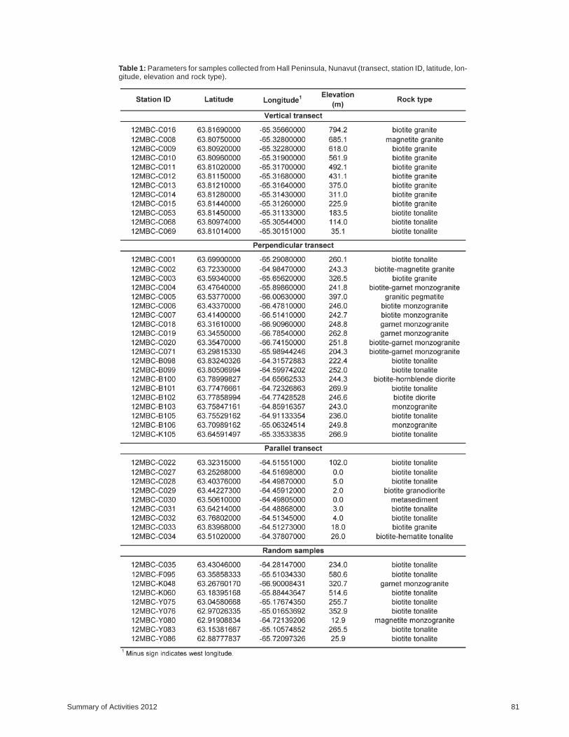
Table 1: Parameters for samples collected from Hall Peninsula, Nunavut (transect, station ID, latitude, lon-gitude, elevation and rock type).

monds varies with depth in a diatreme, knowledge of theexhumation history of Hall Peninsula can help to focus dia-mond exploration in the region.
Acknowledgments
The authors gratefully thank D.J. Mate, G. Machado,C. Bilodeau, T. Tremblay, C.B. Mackay, R.E. From and the2012 CNGO Hall Peninsula field and support crewmem-bers. The support received through both a Natural Sciencesand Engineering Research Council of Canada (NSERC)Discovery Grant and an NSERC Northern Research Sup-plement to J.C. Gosse was also greatly appreciated.
References
Allen, P.A. 2008: From landscapes into geological history; Nature,2008, v. 251, doi:10.1038/nature06586
Arne, D. and Zentilli, M. 1994: Apatite fission track thermochron-ology integrated with vitrinite reflectance; American Chem-ical Society, Symposium Series, v. 570, ch. 16, p. 249–268.
Bornhold, B.D., Finlayson, N.M. and Monahan, D. 1976: Sub-merged drainage patterns in Barrow Strait, Canadian Arctic;Canadian Journal of Earth Sciences, v. 13, p. 305–311.
Braun, J. 2003: Pecube: a new finite-element code to solve the 3Dheat transport equation including the effects of a time-vary-ing, finite amplitude surface topography; Computers &Geosciences, 2003, v. 29, p. 787–794, doi:10.1016/S0098-3004(03)00052-9
Braun, J., van der Beek, P., Valla, P., Robert, X., Herman, F.,Glotzbach, C., Pedersen, V., Perry, C., Simon-Labric, T. andPrigent, C. 2012: Quantifying rates of landscape evolutionand tectonic processes by thermochronology and numericalmodeling of crustal heat transport using PECUBE; Tecton-ophysics, v. 524–525, p. 1–28.
Centeno, J.P. 2005: Exhumation of the Torngat Mountain, north-ern Labrador, Canada; M.Sc. thesis, University of Kansas,Lawrence, Kansas.
Chalmers, J.A. and Pulvertaft, T.C.R. 2001: Development of thecontinental margins of the Labrador Sea: a review; Geologi-cal Society, London, Special Publications, v. 187, no. 1,p. 77–105.
Ehlers, T.A. and Farley, K.A. 2003: Apatite (U–Th)/He thermo-chronometry: methods and applications to problems in tec-tonic and surface processes; Earth and Planetary ScienceLetters, v. 206, no. 1–2, p. 1–14, doi:10.1016/S0012-821X(02)01069-5
Farley, K.A. 2002: (U-Th)/He dating: techniques, calibrations,and applications; Reviews in Mineralogy and Geochemis-try, v. 47 p. 819–844, doi:10.2138/rmg.2002.47.18
Fortier, Y.O. and Morley, L.W. 1956: Geological unity of the Arc-tic Islands; Royal Society of Canada Transactions, v. 50,p. 3–12.
Funck, T., Gohl, K., Damm, V. and Heyde, I. 2012: Tectonic evolu-tion of southern Baffin Bay and Davis Strait: results from aseismic refraction transect between Canada and Greenland;Journal of Geophysical Research, v. 117, 24 p. ,doi:10.1029/2011JB009110
Funck T. and Lounden, K.E. 1999: Wide-angle seismic transectacross the Torngat Orogen, northern Labrador: evidence for
a Proterozoic crustal root; Journal of Geophysical Research,v. 104, no. B4, p. 7463–7480, doi:104:7463-7480
Grist, A.M. and Zentilli, M. 2005: The thermal history of the NaresStrait, Kane Basin, and Smith Sound region in Canada andGreenland: constraints from apatite fission-track and(UThSm)/He dating; Canadian Journal of Earth Sciences,v. 42, no. 9, p. 1547–1569, doi:10.1139/e05-058
Grist, A.M., Ryan, R.J. and Zentilli, M. 1995: The thermal evolu-tion and timing of hydrocarbon generation in the MaritimesBasin of eastern Canada: evidence from apatite fission trackdata; Bulletin of Canadian Petroleum Geology, v. 43, no. 2,p. 145–155.
Harrison, J.C., Brent, T.A. and Oakey, G.N. 2011: Baffin Fan andits inverted rift system of Arctic eastern Canada: stratigra-phy, tectonics and petroleum reserve potential; GeologicalSociety, London, Memoirs 2011, v. 35, p. 595–626,doi:10.1144/M35.40
Helmstaedt, H.H. and Gurney, J.J. 1995: Geotectonic controls ofprimary diamond deposits: implications for area selection;Journal of Geochemical Exploration, v. 53, p. 125–144.
Herman, F., Rhodes, E.J., Braun, J. and Heiniger, L. 2010: Uni-form erosion rates and relief amplitude during glacial cyclesin the Southern Alps of New Zealand, as revealed fromOSL-thermochronology; Earth and Planetary Science Let-ters, v. 297, p. 183–189.
Japsen, P., Bonow, J.M., Green, P.F., Chalmers, J.A. and Lidmar-Bergström, K. 2006: Elevated, passive margins: long-termhighs or Neogene uplifts? New evidence from West Green-land; Earth and Planetary Science Letters, 2006, v. 248,p. 330–339.
Kessler, M.A., Anderson, R.S. and Briner, J.P. 2008: Fjord inser-tion into continental margins driven by topographic steeringof ice; Nature Geoscience, v. 1, no. 6, p. 365–369,doi:10.1038/ngeo201
Montgomery, D.R. 2002: Valley formation by fluvial and glacialerosion; Geology, v. 30, no. 11, p. 1047–1050.
Nielsen, S.B., Gallagher, K., Leighton, C., Balling, N.,Svenningsen, L., Jacobsen, B.H., Thompson, E., Niel-sen, O.B., Heilmann-Clausen, C., Egholm, D.L., Summer-field, M.A., Clausen, O.R., Piotrowski, J.A., Thorsen, M.R.,Huuse, M., Abrahamsen, N., King, C. and Lykke-Andersen, H. 2009: The evolution of western Scandinaviantopography: a review of Neogene uplift versus the ICE (isos-tasy-climate-erosion) hypothesis; Journal of Geodynamics,v. 47, p. 72–95.
Oakey, G.N. 2005: Cenozoic evolution and lithosphere dynamicsof the Baffin Bay–Nares Strait region of Arctic Canada andGreenland; Ph.D. thesis, Vrije Universiteit, Amsterdam.
Oakey, G.N. and Chalmers, J.A. 2012: A new model for the Paleo-gene motion of Greenland relative to North America: platereconstructions of the Dave Strait and Nares Strait regionsbetween Canada and Greenland; Journal of Geophysical Re-search, v. 117, doi:10.1029/2011JB008942
Pulvertaft, T.C.R. and Dawes, P.R. 2011: North Atlantic spreadingaxes terminate in the continental cul-de-sacs of Baffin Bayand the Laptev Sea; Canadian Journal of Earth Sciences,v. 48, p. 593–601.
Ryan, W.B.F., Carbotte, S.M., Coplan, J.O., O’Hara, S., Melkon-ian, A., Arko, R., Weissel, R.A., Ferrini, V., Goodwillie, A.,Nitsche, F., Bonczkowski, J. and Zemsky, R. 2009: Globalmulti-resolution topography synthesis; Geochemistry, Geo-physics, Geosystems, v. 10, doi:10.1029/2008GC002332
82 Canada-Nunavut Geoscience Office

Schenk, C.J. 2011: Geology and petroleum potential of the WestGreenland – East Canadian Province; Geological Society,London, Memoirs 2011, v. 35, p. 627–645.
Scott, D.J. 1999: U-Pb geochronology of eastern Hall Peninsula,southern Baffin Island, Canada: a northern link between theArchean of West Greenland and the PaleoproterozoicTorngat Orogen of northern Labrador; Precambrian Re-search, v. 93, p. 5–26.
Shuster, D.L., Flowers, R.M. and Farley, K.A. 2006: The influenceof natural radiation damage on helium diffusion kinetics inapatite; Earth and Planetary Science Letters, v. 249, p. 148–161.
Skaarup, N., Jackson, H. R. and Oakey, G. 2006: Margin segmen-tation of Baffin Bay/Davis Strait, eastern Canada based onseismic reflection and potential field data; Marine and Pe-troleum Geology, v. 23, p. 127–144.
Staiger. J.W., Gosse, J., Little, E.C., Utting, D.J., Finkel, R., John-son, J.V. and Fastook, J. 2006: Glacial erosion and sedimentdispersion from detrital cosmogenic nuclide analysis of till;Quaternary Geology, v. 1, p. 29–42.
Suckro, K., Gohl, K., Funck, T., Heyde, I., Ehrhardt, A.,Schreckenberger, B., Gerlings, J., Damm, V. and Wilfried, J.2012: The crustal structure of southern Baffin Bay: implica-tions from a seismic refraction experiment; GeophysicalJourna l In t e rna t iona l , v. 190 , no . 1 , p . 37–58 ,doi:10.1111/j.1365-246X.2012.05477.x
Sugden, D.E. 1976: A case against deep erosion of shields by icesheets; Geology, v. 4, p. 580–582.
van der Beek, P., Andriessen, P. and Cloetingh, S. 1995:Morphotectonic evolution of rifted continental margins: in-ferences from a coupled tectonic-surface processes modeland fission track thermochronology; Tectonics, v. 14, no. 2,p. 406–421.
Westgate, J.A., Pearce, G.W., Preece, S.J., Schweger, C.E.,Morlan, R.E., Pearce, N.J.G. and Perkins, T.W. 2012:Tephrochronology, magnetostratigraphy and mammalianfaunas of Middle and Early Pleistocene sediments at twosites on the Old Crow River, northern Yukon Territory, Can-ada; Quaternary Research, dx.doi.org/10.1016/j.yqres.2012.09.003
Wolf, R.A., Farley, K.A. and Kass, D.M. 1998: Modeling of thetemperature sensitivity of the apatite (U-Th)/He thermo-chronometer; Chemical Geology, v. 148, no. 1, p. 105–114.
Wolf, R.A., Farley, K.A. and Silver, L.T. 1996: Helium diffusionand low-temperature thermochronometry of apatite;Geochemica et Cosmochimica Acta, v. 60, no. 21, p. 4231–4240.
Yaehne, S. 2008: Landscape evolution of the Eastern Arctic Rim,Canada; Honours B.Sc. thesis, Dalhousie University, Hali-fax, Nova Scotia.
Summary of Activities 2012 83

84 Canada-Nunavut Geoscience Office