rifting of the south china sea: new...
TRANSCRIPT

Rifting of the South China Sea: new perspectives
Andrew Cullen1, Paul Reemst1,*, Gijs Henstra1, Simon Gozzard1 and Anandaroop Ray2
1Shell International Exploration and Production B.V., Kessler Park 1 / 2288 GS Rijswijk, The Netherlands2Shell Technology India, Bangalore, India
*Corresponding author (e-mail: [email protected])
ABSTRACT: The Cenozoic evolution of SE Asia records a diverse array of tectonicprocesses with rifting, subduction, terrane collision and large-scale continentalstrike-slip faulting occurring in spatially and temporally complex relations. Oligoceneseafloor spreading and rift propagation in the South China Sea are critical tectonicevents that overprint an earlier phase of regional extension. Two end-membermodels proposed to explain the opening of the South China Sea differ in the relativeimportance of extrusion versus subduction as the driving mechanism. This papertreats the South China Sea region as a large multi-phase continental rift basin.Synthesizing recently published studies and using filtered Bouguer gravity data, wemake a series of observations and possible interpretations to advance the notion thata hybrid tectonic models need to be proposed and tested. We present an examplefrom the Phu Khanh Basin where flexural backstripping supports our interpretationthat an ‘out-of-sequence’ rifting event was of sufficient magnitude to completelyattenuate the continental crust in the ultra deep water part of the basin. The complexrift history of the region leads us to believe that future frontier hydrocarbonexploration will carry large uncertainties from basin to basin.
KEYWORDS: South China Sea, rifts, tectonics
INTRODUCTION
The Cenozoic evolution of the South China Sea region encom-passes a broad spectrum of tectonic processes including rifting,seafloor spreading, subduction, terrane collision, and large-scalecontinental strike-slip faulting. Although this plethora of proc-esses makes the region an ideal natural laboratory for tectonicstudies, their close association in time and space clouds ourvision when attempting to distinguish cause from effect. Draw-ing heavily on new filtered Bouguer gravity data, this paperexamines tectonic models for rifting of the South China Sea inrelation to the region’s geological features incorporating theresults of recent studies that post-date those tectonic models.The greater South China Sea is a prolific petroleum provincewith numerous productive basins that have been studied largelyon a case-by-case basis. This study treats the region as a singleoceanic basin with conjugate margins containing multiplesub-basins. Our approach is primarily inquisitive, as we placeour observations in the context of different tectonic models inan attempt to highlight areas on which further research shouldbe focused.
REGIONAL GEOLOGICAL OVERVIEW
The South China Sea (hereafter SCS) rift is expressed as anirregularly shaped triangular area of Oligocene to EarlyMiocene oceanic crust with a SW pointing apex (Fig. 1). The3000 m isobath approximately outlines the continent–oceanboundary ((COB; Briais et al. 1993; Braitenberg et al. 2006).Removing the longer wavelength components (500 km high
pass filter) from the Bouguer gravity signal improves resolutionof shorter wavelength features of the SCS rift. Further enhance-ment of the shorter wavelength features is achieved using a150 km high pass filter rendered semi-transparent and drapedover the 500 km high pass filter (Fig. 2). The axis of the rift isexpressed as a narrow Bouguer gravity low. A series of volcanicseamounts that rise from rift axis and associated transformfaults record a younger, post-rift, episode of igneous activitythat is attributed to the Hainan mantle plume (Tu et al. 1992;Lie et al. 2009). Beyond the COB, two wide areas of attenuatedcontinental crust define the conjugate margins of the SCS rift.In the deeper water areas, horsts and graben of the brittle uppercrust are bathymetrically well expressed, e.g. DangerousGrounds. A series of petroleum-rich pull-apart rift basinsunderlying the shallow shelf on the NW side of the rift (Chinaand Vietnam), have little bathymetric expression owing toburial by Neogene deltaic successions. These basins record acomplex history that includes episodes of extension, wrenchingand inversion. To the SE, the Dangerous Grounds and ReedBank are the expression of attenuated continental crust.Attenuated continental crust also underlies the NW Borneotrough and Baram–Balabac foreland basin (Cullen 2010).
Since the Late Cretaceous at least three episodes of Ceno-zoic extension have affected the SCS region (Ru & Pigott1986). In the Cenozoic we recognize two main episodes ofrifting. The older Paleocene to Eocene episode is very wide-spread; recognized in the Dangerous Grounds (Thies et al.2005), the Phu Khanh Basin (Fyhn et al. 2009a), Luconia(Mat-Zin & Swarbrick 1996), the Pearl River Mouth Basin (Ru& Pigott 1986), onshore Kalimantan (Barito, Kutei, and
Petroleum Geoscience, Vol. 16 2010, pp. 273–282 1354-0793/10/$15.00 � 2010 EAGE/Geological Society of LondonDOI 10.1144/1354-079309-908

Tarakan basins; Satyana et al. 1999) and the Makassar Straits(Guntoro 1999; Hall et al. 2009). Owing to overprinting bysubsequent tectonic events, as well as poor exposures in theheavily vegetated onshore areas, well constrained tectonicmodels for Paleocene to Eocene extension remain to beworked out. This early episode of extension has been attributedto back-arc spreading induced by slab role back around greaterSE Asia (Doust & Sumner 2007). Hall (2009) suggests that acomponent of this older event reflects extension perpendicularto the maximum tectonic stress in what became the upper platefollowing re-initiation of subduction of the Indo-Australia platebeneath Java and Sumatra c. 45 Ma.
A second episode of regional extension occurred from theLate Eocene to Early Miocene. Although not as regionallywidespread as the earlier episode, the amount of crustalthinning in the second episode was of sufficient magnitude toresult in wholesale rifting of Asian continental crust andseafloor spreading in the SCS. Volcanism contemporaneouswith rifting and seafloor spreading is minimal and the SouthChina Sea is regarded as a non-volcanic margin to weaklyvolcanic margin (Yan et al. 2006; Clift & Lin 2001). Althoughwe treat the extensional history of the SCS in terms of twoepisodes, we recognize that these episodes are not independentevents, but stages of a protracted process. To the extent thatheterogeneities in the rheology, thermal gradient, compositionand thickness of the upper mantle and crust are funda-mental boundary conditions that influence rifting (Huismanset al. 2005; Gueydan et al. 2008), rifting in the SCS was stronglyinfluenced by lithosphere-scale perturbations resulting from thefirst episode of extension.
SEAFLOOR SPREADING HISTORY
The timing and kinematics of the seafloor spreading in the SCSrest largely on the interpretation of marine magnetic dataacquired in multiple cruises over the several decades. The earlywork of Taylor & Hayes (1983) and Briais et al. (1993)established that SCS opened in several phases during theOligocene and Early Miocene, c. 32 Ma to 16 Ma and thatat least one major ridge jump occurred. The main tectonicmodels for the region’s evolution (e.g. Lee & Laver 1995; Hall1996, 2002; Replumaz & Tapponnier 2003) rest on this earlierwork.
Additional ship-borne magnetic data acquired specifically toaddress a data gap near Taiwan and uncertainties between theReed and Macclesfield banks introduce two important refine-ments to the spreading history that must be considered withina regional tectonic context. First, additional magnetic anomaliesidentified south of Taiwan across a Luzon transform faultsuggest that SCS oceanic crust could be as old as 37 Ma,magnetic anomaly C17 (Hsu et al. 2004). Second, Barckhausen& Roeser (2004), in a paper reviewed by Hayes and Briais,conclude that seafloor spreading at the SW rift tip ceased at20.5 Ma, anomaly 6A1; approximately 4 Ma earlier than inter-preted in the seminal models for the SCS. Reconstructing theopening history for the SCS from seafloor magnetic anomaliesis complicated by several factors that include difficulty withmagnetic measurements at equatorial latitudes, the presence ofyounger igneous rocks, and post-spreading transpressive defor-mation of the magnetic anomalies (Barckhausen & Roeser2004; Yan et al. 2008). Taking these potential complications into
!"#$% &&%
'&%
(#%
)#
*$%+,,,-
./,%
&'&%
0##
###
12,,-
34
3*(%
5.5.
167%,68%
+68%
/+69
969%+62%
:;#%
&4<=%
>5!%
'0#
!'&%
4?%
$#
;###
$(#
2,,%@-
:*%
:)(#%
!"#
2,,-
"!#%
Fig. 1. Regional setting and featuresmap with ETOPO2v2 bathymetry andShuttle Radar Topography MissionDigital Elevation Model models as anunderlay. The bathymetric map has anon-linear colour bar to assist inhighlighting certain features. Dark greyto black areas are marginal basins andoceanic crust. Offshore Cenozoicsedimentary basins outlined in yellowand black dashed lines. White to lightblue areas correspond to the continentalshelf and upper slope, respectively. BB,Barito Basin; BBB, Baram BalabacBasin; CLB, Cuu Long Basin; CS,Celebes Sea; DG, Dangerous Grounds;HI, Hainan Island; KB, Kutei Basin;LBB, Luconia Balingian Basin; MB,Macclesfield Bank; NCS, Nam Con SonBasin; NWBT, NW Borneo Trough;PKB, Phu Khanh Basin; PRMB; PearlRiver Mouth Basin; PX, PenxiSeamounts; QDN, QuiondongnanBasin; RB, Reed Bank; SCS, SouthChina Sea; SS, Sulu Sea; SH-Y, SongHong-Yengeahai Basin; TB, TarakanBasin; TMB, Thai Malay Basin; WNB,West Natuna Basin; XT, Xisha Trough;ZH, Zenghe Massif (e.g. SpratleyIslands); ZXM, Zongsha-Xisha Massif.Red triangles show location of agedates (reviewed by Yan et al. 2006).AC, possible attenuated crust; G10marks prominent north-trendingstructurally-controlled carbonate build.
A. B. Cullen et al.274

account, Figure 3 is a diagrammatic reconstruction that depictsthree phases of seafloor spreading in the SCS.
37 Ma to 25.5 Ma (anomalies 16 to 7A)
Spreading segments strike east–west and are linked to north–south striking transform faults. The restriction of anomalies
14–16 to the east side of the Luzon transform fault, relative toyounger anomalies, suggests that rifting progressed from east towest. Evidence for east–west propagation comes from theXisha Trough; a narrow east–west trending bathymetric low onthe northern side of the Zhongsha-Xisha Massif (ParacelIslands) that is marked by a modest Bouguer gravity high anddeep bathymetry (Figs 1 & 2). On the basis of these features
XT
1011
12
9
7A8
8
6B
6B
6B
6B
6A1
6A1
Borneo
HI
MB
RB
SH-Y
SS
CS
NCS
RRFZ
WBL
TL
MPFZ
KD
UBF
PKB
1011
12
14
15
16
Taiwan
1110
7
7
LZT
v vv v
G10
EVFZ
ZXM
BBB
PRMB
THSZ
WNFAC?
500 km
MT
ZH
TF1
ZZ Fig. 2. 150 km high pass Bouguergravity map draped over a 500 km highpass Bouguer gravity map. Dashed linearound SCS marks approximate limit ofoceanic crust. Magnetic anomalies arefrom Barckhausen & Roeser (2004).Solid black lines show faults and faultrelays are from Fyhn et al. 2009; Liuet al. 2004; Morley 2002; Pubellier et al.2006; Rangin et al. 1995a; Tongkul1994, 2006; Zhu et al. 2009.Abbreviations as in Figure 1. EVFZ,East Vietnam Fault Zone; KD, KudatPeninsula; LZT, Luzon Transform;MPFZ, Mae Ping Fault Zone; MY,Manila Trench; NCSS, Nam Con SonSwell; RRFZ, Red River Fault Zone;SPO, Sabah-Palawan Ophiolite; THSZ,Tuy Huy Shear Zone; TL, Tinjar Line;TF1, transform fault; WBL, WestBaram Line; UBF, Ulugan Bay Fault;WNF, Wan-Na Fault; ZZ, ZonghsahZone. Open circles show Vietnam hotsprings with waters > 50�C (Quy 1998).Fine black line with filled triangle marksmodern NW Borneo-Palawan collisionzone.
? ?
? ?
24.7 Ma(7) 37 Ma
24.7 Ma
RB
MB
Xisha Trough
25.5 Ma(7A)
37 Ma
25.5 Ma
25.5 Ma
? ?
? ?
RB
MB
RB
MB
? ?
20.5 Ma(6A1)
? ?
37 Ma
PKB
Presnt COB
Fig. 3. Schematic opening history of the South China Sea oceanic spreading system at Magnetic Anomalies 7, 7a and 6A1. Redrawn fromBarckhausen & Roeser (2004) and Hsu et al. (2004).
Rifting of the South China Sea 275

and wide angle, multi-channel 2D seismic data, Qui et al. (2001)interpret the Xisha Trough as a failed rift arm that recordsthinning of the pre-rift continental crust from c. 25 km to 8 km.
25.5 Ma to 24.7 Ma (anomalies 7 to 6B)
Following a minor ridge jump from east of the Xisha Trough toa position approximately 50 km south, spreading segmentswere orientated WSW. This ridge jump is documented byjuxtaposed magnetic anomalies 7 and 9 on the southern side ofthe rift and resulted in rifting of previously formed oceaniccrust (Fig. 2). The Reed and Macclesfield banks are interpretedas representing an originally contiguous region of strong crustthat inhibited propagation of the rift to the SW.
24.7 Ma to 20.5 Ma (anomalies 6B to 6A1)
An important ridge jump across a transform fault occurred at24.7 Ma as the rift propagated SW into continental crustsplitting the Reed and Macclesfield banks with seafloor spread-ing directed NW to SE. Magnetic anomalies related to seafloorspreading do not extend to the rift tip (Fig. 2) and it is notknown whether the SW limit of the rift is underlain by oceaniccrust or exhumed mantle. The SW limit of oceanic crust istaken from a study by Huchon et al. (2001) that documentsdextral oblique faulting near the rift tip and that the rift isasymmetric with thicker continental crust on the southern(Dangerous Grounds) conjugate margin. Bouguer gravity dataindicate that SE of the rift tip the Dangerous Groundsrepresents a much wider area of attenuated continental crust
than is present on the Vietnamese margin. Although a wide areaof attenuated continental crust may reflect a low strengthductile lithosphere (Guyedan et al. 2008), some of the observedfaulting in the upper crust occurred during the earlier episodeof regional extension (Thies et al. 2005).
TECTONIC MODELS
In considering the rifting history of the SCS within a tectonicframework there are two contrasting end-member kinematic-tectonic models: the collision-extrusion model (Fig. 4a) andsubduction-collision model (Fig. 4b). Each of the models hasstrong points and resolution of their differences will probablyrequire adaptation of components of each model. Extrusion-based models (e.g. Briais et al. 1993; Replumaz & Tapponnier2003) show opening of the SCS as driven by the SE displace-ment of the Indochina block along the Mae Ping and AilaoShan-Red River fault zones owing to India’s collision with Asia.Subduction-based models (e.g. Hall 2002; Hall et al. 2008)suggest the SCS opened in response to slab pull duringsubduction of proto-South China oceanic crust. A variation onthese models suggests additional lithospheric thinning related tothe Hainan mantle plume is required to initiate seafloorspreading (Xia et al. 2006).
Collision-extrusion model
In the extrusion model, India’s collision with Asia progressivelydisplaces a series of blocks along inter-continental strike-slip
Fig. 4. Comparison of tectonic models for the region at 40 Ma, 30 Ma, and 20 Ma. (a) The extrusion model is adapted from Replumaz &Tapponier (2003). (b) The subduction model is modified from Hall (2002). Abbreviations as in prior figures, filled triangles are on the upperplate at active subduction zones. West Baram Line as transform fault after Morley (2002) is dashed line. Arcs with arrows on Borneo indicatesense of rotation predicted by different models.
A. B. Cullen et al.276

faults. Borneo and Palawan remain attached to Indochina andthe SCS is pulled open by the left-lateral displacement of theIndochina Block along long intercontinental strike-slip, particu-larly the Ailao Shan-Red River fault zone (ASRR; Tapponnieret al. 1986). In the extrusion model, SCS seafloor spreadingterminates when India penetrates far enough into Asia to nolonger push Indochina aside. The extrusion model requires thatthe amount of seafloor spreading in the SCS is roughly equal tothe lateral displacements along the intercontinental strike-slipand predicts c. 25� clockwise (CW) rotation of Indochina andBorneo. In the extrusion model there is no subduction underNW Borneo and mass is conserved by subduction in the PacificOcean. Although there are variants of the extrusion model,each requires that major transcurrent faults extend across theSCS essentially forming a giant hook. Briais et al. (1993) do notexplicitly show how the ASRR fault zone extends into the SCS.LeLoup et al. (2001) link the Mae Ping fault with the WestBaram Line; whereas Replumaz & Tapponnier (2003) show theASRR linking with the East Vietnam Fault that in turn links tothe SW side of the oceanic spreading ridge.
Whilst geometrically elegant, the extrusion model has beenquestioned on multiple grounds: the lack of palaeomagneticevidence for clockwise rotation on Borneo (Fuller et al. 1999),the lack of evidence for through-going faults across the SCS
and disagreement over the amount and timing of strike-slipdisplacement on the major fault zones relative to the age ofseafloor spreading (Morley 2002; Searle 2006; Hall et al. 2008).The older, Eocene, magnetic anomalies in the NE part of theSCS (Hsu et al. 2004) are particularly problematic for thecollision-extrusion, as these pre-date estimates for the earlieststrike-slip motion on the ASRR (LeLoup et al. 1995). Theextrusion model has difficulty in accounting for the wide area ofattenuated continental crust on both sides of the continent–ocean boundary; as the Dangerous Grounds lies SE of the areabeing pulled away from Asia.
Subduction-collision model
Dating to the work of Hamilton (1979) and Holloway (1982),the subduction model, in sharp contrast with the extrusionmodel, features long-lived subduction beneath NW Borneo(e.g. Lee & Laver 1995; Hall 1997). Proposed variations of thesubduction model generally show that subduction of theproto-SCS oceanic crust commenced between the Paleocene toMiddle Eocene and ended (in the area of the Baram–BalabacBasin) in the Early Miocene with the arrival of buoyantattenuated continental crust of the Dangerous Grounds at thesubduction (Hall 1997; Longley 1997; Murphy 1998; Morley
Figure 5
XT
BBB
PKB
LBB
Figure 5b
Figure 5c
WBL
MB
Fig. 5b
WBL
TL
G10
100 km
G10
Fig. 5c
RB
ZZ
ZZ
EVFZ
BBB
AC?
AC?
EVFZ
JB
JB
Fig. 5. 150 km high pass Bouguer gravity map draped over a 500 km high pass Bouguer gravity map. Abbreviations as in Figures 1 & 2; ZZ,Zongsha Zone. Dashed lines mark interpreted faults and dashed white lines outline gravity lows interpreted as narrow graben. Figures 5b and5c (outlined in white on Fig. 5) show the 150 km high pass Bouguer gravity map draped over the 1st vertical derivative of the 150 km high passBouguer gravity data, which enhances edge effects related to faulting.
Rifting of the South China Sea 277

2002; Hall 2002). The Sabah Orogeny is attributed to collisionof the Dangerous Grounds with NW Borneo c. 18 Ma(Hutchison et al. 2000).
There are several variants of the subduction theme withimportant differences. These differences arise from conflictingviews on the roll of extrusion of Indo-China, the drivingmechanism for opening the SCS, the rotation of Borneo, andthe amount of proto-SCS that was subducted. In the models ofHall (2002, 2009) rifting in the SCS is driven by slab pull of thesubducting proto-SCS, which is progressively consumed as thesubduction zone tip line migrates SW–NE from Sarawak toPalawan from 45–15 Ma. In those models, the width of theproto-SCS outboard of Borneo remains little changed between45 Ma and 30 Ma and nearly all of the subduction beneathBorneo occurs between 30 Ma and 15 Ma as the island isshown to rotate 50� counter clockwise (CCW); honouringpalaeomagnetic data interpreted by Fuller et al. (1999). Theconsumption of relatively little proto-SCS crust under Borneoprior to 30 Ma appears to pose a geometric problem forinvoking slab pull to open the SCS, as there appears to berelatively little subduction to pull apart the crust. A kinematicinconsistency arises from the observation that the rifting inthe SCS progressed NE to SW opposite the direction ofsubduction tip line migration.
Hybrid models
Several hybrid models have been proposed to help resolveincompatibilities in the end-member models. Reconstructionsby Longley (1997) and Murphy (1998), retaining elements ofthe extrusion model, show multiple CW rotating blocks(Luconia, Baram, Dangerous Grounds, Reed Bank) separatedby transform faults colliding with NW Borneo and Palawanfrom 45–15 Ma. Rangin et al. (1999) suggest that extrusion wasaccompanied by subduction of a relatively narrow (c. 300 km)proto-SCS beneath NW Borneo along a SW migrating collision.Morley (2002), questioning the amount of young CCW rotationof Borneo, presents a subduction-collision model which linksthe ASRR to the West Baram Line using the East VietnamFault as a relay. Cullen (2010), in a study focused on NWBorneo, interprets new biostratigraphic and palaeomagneticdata to indicate minimal Oligo–Miocene subduction and sug-gests rifting in the SCS was accommodated over a wide zone bymultiple mechanisms that included crustal shortening (includ-ing continental underthrusting) in Borneo and subduction inthe Pacific Ocean.
Geodynamic considerations
Over the previous decade several papers have drawn attentionto nature of the mantle beneath the greater Southeast Asiaregion and to the role that mantle upwelling and plumes mayhave played in rifting of the SCS. Age determinations, majorand trace element concentrations, and isotopic ratios of theigneous rocks from the region suggest the widespread presenceof Precambrian subcontinental lithosphere (under the Sulu Arcand Sabah (Castillo 1996; Macpherson et al. 2010), MountKinabalu in Sabah (Cottam et al. 2010), Dangerous Grounds(Yan et al. 2010; Kudrass et al. 1986), SE China (Xu et al. 2002))that is underlain by mantle having a Dupal-like Indian Ocean toenriched ocean-island basalt composition (Tu et al. 1992;Castillo 1996; Macpherson et al. 2010). Petrological and geo-physical evidence demonstrate a youthful mantle plume liesbeneath Hainan Island (Zou & Fan 2010; Lei et al. 2009).Plume-related volcanism in the region could be as old as 60 Ma(Zhou et al. 2009) and ultimately be related to deep subduction
slab dehydration (Zhao & Ohtani 2009). Geodynamic model-ling suggests that neither the subduction model nor theextrusion model produce sufficient extension to trigger seafloorspreading and that additional thinning of the crust and litho-spheric by asthenosphere upwelling is required to drive theopening and spreading of the SCS (Xia et al. 2006).
OBSERVATIONS / INTERPRETATIONS
The use of potential field data, such as Bouguer gravity, is animportant tool for addressing and resolving tectonic models,especially in areas with minimal seismic and borehole infor-mation. Largely on the basis of gravity and bathymetric data, inlight of the prior discussion of tectonic models and drivingmechanisms for rifting in the SCS, we make several observa-tions and propose interpretations of these data. Our interpre-tations are non-unique and our intent is to stimulate discussionby providing new ideas to be challenged with further research.
1. As a first order observation we note that there is an excellentcorrespondence between strong Bouguer gravity highs,bathymetric lows, and extremely attenuated continental crustin the Xisha Trough and at the SW tip of the SCS rift.
2. Attenuated continental crust can be traced 700 km acrossthe Dangerous Grounds, the NW Borneo Trough and theBaram–Balabac Basin. Thus, the region can be classified as awide rift (Buck 1991). A wide zone of attenuated crustbeyond the COB implies a mechanically weak upper mantleprior to rifting (Gueydan et al. 2008). We propose that theearlier Eocene episode of extension is responsible formechanically weakening the mantle prior to the secondepisode of extension.
3. The NW Borneo Trough is characterized by very deep waterand a Bouguer gravity low, and thus shares characteristicswith the Xisha Trough. Seismic data show that riftedcontinental crust extends beneath the Baram–Balabac Basin(Franke et al. 2008; Cullen 2010) and it is tempting tospeculate that the basin is underlain by extremely attenuatedcrust. However, quantitative modelling indicates that Bou-guer gravity low of the NW Borneo Trough is due todynamic loading by the NW Borneo thrust belt whichpushes the SCS crust below its level of isostatic compensa-tion (Milsom et al. 1997) which exaggerates the contrast withadjacent areas. We propose that the Bouguer gravity highsbeneath the Baram–Balabac Basin are the expression ofsmall rift basins similar to those of the Dangerous Grounds.The 150 km high pass gravity data with enhanced edgedetection indicates that the Baram–Balabac Basin is under-lain by north–south, NE–SW and NW–SE striking base-ment faults similar to the fault orientations on theDangerous Grounds (Fig. 5).
4. The West Baram Line which separates Luconia from theBaram–Balabac Basin is generally treated as a major tectonicfeature that may have accommodated significant strike-slipmotion during extrusion of Indochina. Luconia is an olderblock sutured to Borneo during the Middle Eocene SarawakOrogeny (Hutchison 1996). On the filtered gravity data,Luconia has a distinctive character with subdued northerly-trending anomalies, one of which extends across the WestBaram Line at the G10 high (Fig. 5). This subdued characterin part reflects burial by a thick Pliocene sedimentary sectionand masking by Miocene platform carbonates and reefs. Theobservation that structural trends appear to extend acrossthe West Baram Line from Luconia into the DangerousGrounds is problematic for invoking major strike-slipmotion (e.g. >100 km) across the West Baram Line.
A. B. Cullen et al.278

5. The Sabah-Palawan Ophiolite is well expressed by a stronggravity high and displays an apparent left-lateral offset acrossthe Ulugan Bay fault (Fig. 2). The Ulugan Bay fault, whichhas been interpreted as a right lateral transform fault (Ru &Pigott 1986), projects northward toward the Luzon Trans-form Fault on the northern side of the SCS rift. On theKudat peninsula in northern Sabah thrust faults placingEocene turbidites over Early Miocene shallow to deep-waterclastics are interpreted to be related to opening of the SCS(Tongkul 1994, 2006). These observations and the relativelywidespread north–south fabric expressed on the regionalgravity lead us to concur that at least part of the opening ofthe SCS has been accommodated by shortening on Borneo(Tongkul 1994; Cullen 2010).
6. At the SW tip of the SCS oceanic crust near the Nam ConSon Basin, the rift is much wider on the SE (Borneo) siderelative to the NW (Phu Khanh Basin) side (Figs 2&5). Thebasement structure map in the area of the rift tip shows adominance of down-to-the-NW normal faults (Huchon et al.2001, fig. 6). We suggest that this area may have experienceda greater component of simple shear (e.g. Wernicke 1985)extension.
7. South of the Zongsha-Xisha Massif and the MacclesfieldBank, the Penxi Seamounts lie along a NW–SE trendingzone of high Bouguer gravity (Figs 1, 2, 5) that projects intoa bend in the Qiongdongnan Basin (QDN). We informallyrefer to this feature as the Zongsha Zone (ZZ). On the150 km high pass Bouguer gravity data (Fig. 5) the ZongshaZone appears to be cut by a series of NE–SW strikinggravity anomalies that can be interpreted as extensional faultblocks along a left-lateral shear, implying that the QDNBasin may have developed as a left-stepping releasing bendalong an ancestral branch of the Red River Fault Zone, priorto its capture and relay into the East Vietnam Fault Zone, ina relationship similar to that proposed between the Mae PingFault and the Cuu Long Basin (Matthews et al. 1997; Morley2002). The correspondence between the intersection ofthe ZZ with limit of well developed magnetic anomaliessuggests the ZZ is an important tectonic feature (Fig. 2).
8. The Phu Khanh Basin lies athwart the East Vietnam Fault(EVF). East of a prominent bathymetric scarp that marksthe trace of that fault, the ultra deepwater part of the basinis marked by a strong Bouguer gravity high (Fig. 5), whichcorresponds to region with an elastic thickness of less than1 km (Braitenberg et al. 2006). Similar features are associatedwith the failed rift arm of the Xisha trough. We hypothesizethat the eastern part of the Phu Khanh Basin is underlain byextremely attenuated continental crust.
9. We have highlighted an area (AC?) between the Nam ConSon Basin and Luconia-Balingian Basin that has a strongBouguer gravity high associated with deep water (Figs 1,2&5). Features similar to those are associated with stronglyattenuated crust of the eastern Phu Khanh Basin. Faultpatterns suggest that splays of the EVF, such as the Wan-NaFault, extended further to the south than the Tuy Huy shearzone. Further work may reveal that area AC is also one ofstrongly attenuated crust.
ADDITIONAL WORK ON THE PHU KHANHBASIN
We tested the hypothesis regarding extreme crustal thinning inthe Phu Khanh Basin by determining whole lithosphere thin-ning factors along a published cross-section (Fig. 6 is modifiedfrom Fyhn et al. 2009a, fig. 3). We assume an initial crustalthickness of 35 km (Holt 1998; Clift et al. 2002). The cross-
section was flexurally backstripped to the base of the MiddleMiocene sediments (model A) and to the base of the Middle toUpper Eocene sediments (model B) to determine water loadedsubsidence profiles using the lithosphere extension model ofMcKenzie (1978) modified to include volcanic addition at highthinning factors (White & McKenzie 1989).
Models A and B both show post-rift thermal subsidence(St-only) rapidly reaching a value of one, e.g. a beta factorapproaching infinity. The numerical solution in both models
MS4-II Pliocene to Recent
MS4-I Late Miocene to Pliocene
MS3-IV Middle to Late Miocene
MS3-III Early to Middle Miocene
MS3-II Late Oligocene Early Miocene (post-rift sag
4 km
Early Cenozoic to Mesozoic (pre-rift)
MS 1&2 Eocene to Late Oligocene (syn-rift)
Fig. 6. Depth converted model with sediments flexurally back-stripped to produce water loaded subsidence profiles. Model A & Bresults are from a McKenzie lithosphere extension model, modifiedto include volcanic addition at high thinning factors. Whole thinningfactors for the lithosphere have been determined from the waterloaded subsidence. Model A assumes a rift event in the LowerMiocene; model B assumes a rift event in the mid to Upper Eocene.Post rift thermal subsidence alone cannot account for the waterloaded subsidence observed in both models; and results from modelB suggests that the Phu Khanh basin consists of highly thinnedcontinental crust with a large component of volcanic addition. Si,subsidence initial; St, subsidence thermal; WLS, water-loaded subsid-ence, b, stretching factor.
Rifting of the South China Sea 279
requires whole lithospheric thinning factors exceeding one inorder to account for the observed whole lithosphere subsid-ence. Such solutions are physically impossible and are notplotted. Therefore, additional initial (syn-rift) subsidence (Si) isrequired.
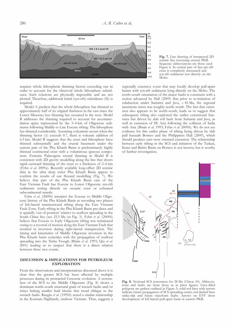
Model A predicts that the whole lithosphere has thinned toapproximately half of its original thickness in the east since theLower Miocene; less thinning has occurred in the west. ModelB addresses the thinning required to account for accommo-dation space represented by the 3–4 km of Oligocene sedi-ments following Middle to Late Eocene rifting. The lithospherehas thinned considerably. Assuming volcanism occurs when thethinning factor (�) exceeds 0.7, there is volcanic addition of6.5 km. Model B suggests that the crust and lithosphere havethinned substantially and the crustal basement under theeastern part of the Phu Khanh Basin is predominately highlythinned continental crust with a voluminous igneous compo-nent. Extreme Palaeogene crustal thinning in Model B isconsistent with 2D gravity modelling along the line that showsrapid eastward thinning of the crust to a thickness of 2–6 km(Fyhn et al. 2009a). Recently available long-offset 2D seismicdata in the ultra deep water Phu Khanh Basin appear toconfirm the results of our flexural modelling (Fig. 7). Webelieve that part of the Phu Khanh Basin east of theEast Vietnam Fault has Eocene to Lower Oligocene syn-riftsediments resting directly on oceanic crust or exhumedsubcontinental mantle.
Fyhn et al. (2009b) interpret the Eocene to Middle Oligo-cene history of the Phu Khanh Basin as recording two phasesof left-lateral transtensional rifting along the East VietnamFault Zone. Early rifting in the Phu Khanh Basin pre-dates andis spatially ‘out of position’ relative to seafloor spreading in theSouth China Sea (see 25.5 Ma on Fig. 3). Fyhn et al. (2009b)believe that Eocene to Early Oligocene rifting was terminatedowing to a reversal of motion along the East Vietnam Fault thatresulted in inversion during right-lateral transpression. Thetiming and kinematics of Middle Oligocene inversion in thePhu Khanh basin coincides with the propagation of seafloorspreading into the Xisha Trough (Briais et al. 1993; Qiu et al.2001) leading us to suspect that there is a direct relationbetween these two events.
DISCUSSION & IMPLICATIONS FOR PETROLEUMEXPLORATION
From the observations and interpretations discussed above it isclear that the greater SCS has been affected by multipleprocesses during its protracted Cenozoic evolution. A restora-tion of the SCS to the Middle Oligocene (Fig. 8) shows adominant north–south structural grain of wrench faults and/orrelays linking smaller fault blocks that trend oblique to thewrench faults. Rangin et al. (1995b) noted a similar relationshipin the Kontum Highlands, onshore Vietnam. Thus, suggests a
regionally extensive event that may locally develop pull-apartbasins with syn-rift sediments lying directly on the Moho. Thenorth–south orientation of the major faults is consistent with anotion advanced by Hall (2009) that prior to re-initiation ofsubduction under Sumatra and Java, c. 45 Ma, the regionalmaximum stress was roughly north–south. The fact that exten-sion also appears to be north–south, leads us to suggest thatsubsequent rifting also exploited the earlier extensional frac-tures but driven by slab roll back from Sumatra and Java, aswell as extrusion of SE Asia following the collision of Indiawith Asia (Briais et al. 1993; Fyhn et al. 2009b). We do not seeevidence for this earlier phase of rifting being driven by slabpull beneath Borneo and the Philippines Hall (2009), whichshould produce east–west oriented extension. The relationshipbetween early rifting in the SCS and initiation of the Tarkan,Kutei and Barito Basin on Borneo is not known, but is worthyof further investigation.
1.0
2.0
3.0
4.0
5.0
6.0
7.0
8.0
9.0
10.0mantle
pre-rift crust pre-rift crust
MS 1 & 2 syn-rift
50 km
MS 3 & 4 post-rift
Moho
West Easttwtsec.
water bottom
Fig. 7. Line drawing of interpreted 2Dseismic line traversing eastern PKB.Sequence abbreviations are those usedFigure 6. In central part of line pre-riftcrust is completely attenuated andsyn-rift sediments rest directly on theMoho.
RB
MB
G10
XT
RB
present day
WNF
THSZZM
ZM
TF1
ZZ
EVF
Fig. 8. Notional SCS restoration for 28 Ma (Chron 10). Abbrevia-tions and faults are from those as in prior figures. Grey-filledpolygons are graben outlined in Figure 5; solid red lines with arrowsindicate future propagation of SCS spreading centre; red dashed linesstrike-slip and future transform faults. Arrows on EVF showdevelopment of left-lateral pull-apart basin in eastern PKB.
A. B. Cullen et al.280

The SCS rift shows a marked change in orientation in thepost-25 Ma spreading geometry when it propagated to the SWthrough the older north–south system. Several NW–SE strikingfaults beyond the SCS spreading centre obscure the older faults.Neogene spreading in the SCS can be viewed as a consequenceof a slab-pull associated with subduction of the proto-SCSfollowing cessation of extrusion of the Indo-China Block (Hall2002; Fyhn et al. 2009b). An alternate model proposed byCullen (2010), interprets minimal Neogene subduction underBorneo and suggests a hybrid model of extrusion and crustalshortening needs to be considered (see also Zhu et al. 2009;Sun et al. 2009).
We note that reversals, left- to right-lateral motion alongmajor fault systems, such as the Red River, represent relativemotion between blocks and that from a regional tectonicperspective both blocks could still be ‘extruding’ away fromAsia. From a geodynamic standpoint it appears that additionalthinning of the lithosphere by asthenosphere upwelling isrequired to drive opening of the SCS (Xia et al. 2006). Giventhe complex subduction history around the region the conceptof ‘splash plumes’ produced by instabilities at the edges ofdownwelling mantle (Davies & Bunge 2006) may prove usefulin explaining some of the anomalous patterns in the SCS.
With respect to petroleum exploration in the frontier areasof the SCS, either deeper in presently productive basins oroutboard towards the SCS spreading centre, our observationssuggest complexity and surprises. Given the overprinting ofmultiple rift events, predicting age, depositional environments,and thermal history ahead of the drill bit will be challenging.
CONCLUSIONS
Multiple processes have contributed to the evolution of the SCSrift making this region an ideal laboratory to study the complexi-ties of rifting. Earlier end-member tectonic models have beeninvaluable in providing a framework for subsequent studies tochallenge. The use of filtered gravity data provides a useful toolfor looking at potential tectonic features related to SCS riftingand the extrusion of Indochina. Our observations suggest thatalthough rifting preceded collision-extrusion, the latter stronglyinfluenced the former. Although rifts are a target-rich environ-ment, frontier exploration in the South China Sea will bechallenging because its complex evolution will limit inter-basinpredictability for its petroleum systems. Improving our under-standing of the region’s tectonic evolution through develop-ment of hybrid models would greatly benefit from futuremulti-national, industry-academic-governmental joint studies.
We gratefully acknowledge Shell permission to present our work atthe Rifts Renaissance Conference and for support in publishing thispaper. We have benefited from lively discussions with Diete Franke,Ude Barckhausen, Nick Kusznir and Jon Teasdale at various stagesof this study. Whilst we bear the responsibility of any remainingshortcomings in this paper, we acknowledge the benefit of construc-tive reviews by Steve Bergman and an anonymous reviewer.
REFERENCES
Barckhausen, U. & Roeser, H.A. 2004. Seafloor spreading anomalies in theSouth China Sea revisited. In: Clift, P., Wang, P., Kuhnt, W. & Hayes, D.(eds) Continent–Ocean Interactions with East Asian Marginal Seas. AmericanGeophysical Union, 140, 121–125.
Briais, A., Patriat, P. & Tapponnier, P. 1993. Updated interpretation ofmagnetic anomalies and seafloor spreading stages in the South China Sea:Implications for the Tertiary tectonics of Southeast Asia. Journal ofGeophysical Research, 98B, 6299–6328.
Braitenberg, C., Wienecke, S. & Wang, Y. 2006. Basement structures fromsatellite-derived gravity field: South China Sea ridge. Journal of GeophysicalResearch, 111B, 1–15.
Buck, W.R. 1991. Modes of continental lithosphere extension. Journal of
Geophysical Research, 96 (B12), 20161–20178.Castillo, P.R. 1996. The origin and geodynamic implication of the Dupal
isotopic anomaly in volcanic rocks from the Philippine island arcs. Geology,24, 271–274.
Clift, P.D. & Lin, J. 2001. Patterns of extension and magmatism along thecontinent–ocean boundary, South China margin. In: Wilson, R.C.,Whitmarsh, R.B., Taylor, B. & Froitzheim, N. (eds) Non-Volcanic Rifting of
Continental Margins: A Comparison of Evidence from Land and Sea. GeologicalSociety, London, Special Publications, 187, 489–510.
Clift, P., Lin, J. & Barckhausen, U. 2002. Evidence of low flexural rigidity andlow viscosity lower continental crust during continental break-up in theSouth China Sea. Marine and Petroleum Geology, 19, 951–970.
Cottam, M., Hall, R., Sperber, C. & Armstrong, R. 2010. Pulsed emplacementof a layered granite: new high-precision age data from Mount Kinabalu,North Borneo. Journal of the Geological Society of London, 167, 49–60.
Cullen, A.B. 2010. Transverse segmentation of the Baram–Balabac Basin,NW Borneo: refining the model of Borneo’s tectonic evolution. Petroleum
Geoscience, 16, 3–29.Davies, J.H. & Bunge, H.P. 2006. Are splash plumes the origin of minor
hotspots? Geology, 34, 349–352.Doust, H. & Sumner, H.S. 2007. Petroleum systems in rift basins – a
collective approach in Southeast Asian basins. Petroleum Geoscience, 13,127–144.
Franke, D., Barckhausen, U., Heyde, I., Tingay, M. & Ramli, N. 2008. Seismicimages of a collision zone offshore NW Sabah/Borneo. Marine and
Petroleum Geology, 25, 606–624.Fuller, M., Ali, J.R., Moss, S.J., Frost, G.M., Richter, B. & Mahfi, A. 1999.
Paleomagnetism of Borneo. Journal of Asian Earth Sciences, 17, 3–24.Fyhn, M.B.W., Nielsen, L.H. et al. 2009a. Geological evolution, regional
perspectives and hydrocarbon potential of the northwest Phu KhanhBasin, offshore Central Vietnam. Marine and Petroleum Geology, 26, 1–24.
Fyhn,, Michael, B.W., Boldreel, L.O. & Nielsen, L.H. 2009b. Geologicaldevelopment of the central and south Vietnamese margin: Implications forthe establishment of the South China Sea, Indochinese escape tectonicsand Cenozoic volcanism. Tectonophysics, doi: 10.1016/j.tecto.2009.08.002.
Gueydan, F., Morency, C. & Brun, J.P. 2008. Rifting as a function oflithosphere mantle strength. Tectonophysics, 460, 83–93.
Guntoro, A. 1999. The formation of the Makassar Strait and the separationbetween SE Kalimantan from SW Sulawesi. Journal of Asian Earth Sciences,17, 79–98.
Hall, R. 1996. Reconstructing Cenozoic SE Asia. In: Murphy, R.W. (ed.)Petroleum Geology of Southeast Asia. Geological Society, London, SpecialPublications, 126, 11–23.
Hall, R. 1997. Cenozoic plate reconstructions of SE Asia. In: Hall, R. &Blundell, D.J. (eds) Tectonic Evolution of Southeast Asia. Geological Society,London, Special Publications, 106, 153–184.
Hall, R. 2002. Cenozoic geological and plate tectonic evolution of SE Asiaand the SW Pacific: computer-based reconstructions, model andanimations. Journal of Asian Earth Sciences, 20, 353–431.
Hall, R. 2009. Hydrocarbon basins in SE Asia: understanding why they arethere. Petroleum Geoscience, 15, 131–146.
Hall, R., van Hattum, M.W.A. & Spakman, W. 2008. Impact of India–Asiacollision on SE Asia: the record in Borneo. Tectonophysics, 451, 366–369.
Hall, R., Cloke, I., Nur’aini, S., Puspita, S., Calvert, S & Elders, C. 2009.The North Makassar Straits: what lies beneath? Petroleum Geoscience, 15,147–158.
Hamilton, W. 1979. Tectonics of the Indonesian Region. United States GeologicalSurvey Professional Paper, 1078.
Holloway, N.H. 1982. North Palawan Block, Philippines – Its Relation toAsian Mainland and Role in the Evolution of South China Sea. American
Association of Petroleum Geologists, Bulletin, 66, 1355–1383.Holt, R.A. 1998. The Gravity Field of Sundaland – acquisition, assessment and
interpretation. Unpublished Ph.D. Thesis. Birkbeck College and UniversityCollege, University of London.
Hsu, S., Yeh, Y., Doo, W. & Tsai, C. 2004. New bathymetry and magneticlineations identifications in the northernmost South China Sea and theirtectonic implications. Marine Geophysical Researches, 25, 29–44.
Huchon, P., Nguyen, T.N.H. & Chamot-Rooke, N. 2001. Propagation ofcontinent break-up in the south-western South China Sea. In: Wilson,R.C., Whitmarsh, R.B., Taylor, B. & Froitzheim, N. (eds) Non-Volcanic
Rifting of Continental Margins: A Comparison of Evidence from Land and Sea.Geological Society, London, Special Publications, 187, 31–50.
Huismans, R.S., Buiter, S.J.H. & Beaumont, C. 2005. Effect of plastic-viscouslayering and strain softening on mode selection during lithosphericextension. Journal of Geophysical Research, 110, B02406–B003114.
Rifting of the South China Sea 281

Hutchison, C.W. 1996. The ‘Rajang Accretionary Prism’ and ‘Lupar Line’Problem of Borneo. In: Hall, R. & Blundell, D.J. (eds) Tectonic Evolution of
Southeast Asia. Geological Society, London, Special Publications, 106,247–261.
Hutchison, C.S., Bergman, S.C., Swauger, D. & Graves, J.E. 2000. A Miocenecollisional belt in north Borneo, uplift mechanism and isostatic adjustmentquantified by thermochronology. Journal of the Geological Society, London, 157,783–793.
Kudrass, H. R., Wiedicke, M., Cepek, P., Kreuzer, H. & Muller, P. 1986.Mesozoic and Cenozoic rocks dredged from the South China Sea (ReedBank area) and Sulu Sea and their significance for the plate-tectonicreconstructions. Marine and Petroleum Geology, 3, 19–30.
Lee, G.H., Lee, K. & Watkins, J.S. 2001. Geological evolution of the CuuLong and Nam Con SonBasins, offshore southern Vietnam, South ChinaSea. American Association Of Petroleum Geologists Bulletin. 85, 1055–1082.
Lee, T.Y. & Laver, L.A. 1995. Cenozoic plate reconstructions of theSoutheast Asia. Tectonophysics, 251, 85–138.
Leloup, P.H., Lacassin, R et al. 1995. The Ailao Shan-Red River shear zone(Yunnan, China), Tertiary transform boundary of Indochina. Tectonophysics,251, 3–84.
Leloup, P.H., Arnaud, N. et al. 2001. New constraints on the structure,thermochronology and timing of the Ailao Shan–Red River shear zone, SEAsia. Journal of Geophysical Research, 66, 1083–6732.
Lei, J., Zhao, D. et al. 2009. New seismic constraints on the upper mantlestructure of the Hainan plume. Physics of the Earth and Planetary Interiors, 173,33–50.
Liu, H-l., Yan, P. et al. 2004. Role of the Wan-Na fault system in the westernNansha Islands (Southern South China Sea). Journal of Asian Earth Sciences,23, 221–233.
Longley, I.M. 1997. The tectonostratigraphic evolution of SE Asia. In:
Murphy, R.W. (ed.) Petroleum Geology of Southeast Asia. Geological Society,London, Special Publications, 126, 311–339.
Macpherson, C.G., Chaing, K. et al. 2010. Plio-Pleistocene intra-plate mag-matism from the southern Sulu Arc, Semporna peninsula, Sabah, Borneo:Implications for high-Nb basalt in subduction zones. Journal of Volcanology
& Geothermal Research, 190, 25–38, doi: 10.1016/jvolgeores.2009.11.004.Matthews, S.J., Fraser, A.J., Lowe, S., Todd, S.P. & Peel, F.J. 1997. Structure,
stratigraphy and petroleum geology of the SE Nam Con Son, offshoreVietnam. In: Fraser, A.J., Matthews, S.J. & Murphy, R.W. (eds) Petroleum
Geology of Southeast Asia. Geological Society, London, Special Publications,126, 89–106.
Mat-Zin, I.C. & Swarbrick, R.E. 1997. The tectonic evolution and associatedsedimentation history of Sarawak Basin, eastern Malaysia: a guide forfuture hydrocarbon exploration. In: Fraser, A.J., Matthews, S.J. & Murphy,R.W. (eds) Petroleum Geology of Southeast Asia. Geological Society, London,Special Publications, 126, 237–245.
McKenzie, D.P. 1978. Some remarks on the development of sedimentarybasins. Earth and Planetary Science Letters, 40, 25–32.
Milsom, J., Holt, R., Ayub, D. & Smail, R. 1997. Gravity anomalies and deepstructural controls at the Sabah-Palawan margin, South China Sea. In:
Fraser, A.J., Matthews, S.J. & Murphy, R.W. (eds) Petroleum Geology of
Southeast Asia. Geological Society, London, Special Publications, 126,417–427.
Morley, C.K. 2002. A tectonic model for the Tertiary evolution of strike-slipfaults and rift basins in SE Asia. Tectonophysics, 347, 189–215.
Murphy, R.W. 1998. SE Asia reconstruction with a non-rotating Borneo.Geological Society of Malaysia Bulletin, 42, 85–94.
Pubellier, M., Rangin, C. & Le Pichon, X. 2006. Memoir de la SociétéGéologique de France. 176, DOTSEA, Deep Offshore Tectonics Southeast Asia.American Association of Petroleum Geologists, Tulsa, OK.
Qiu, X., Sanyu, Y. et al. 2001. Crustal structure across the Xisha Trough,northwestern South China Sea. Tectonophysics, 341, 179–193.
Quy, H.H. 1998. Overview of Geothermal Potential of Vietnam. Geothermics,27, 109–115.
Rangin, C., Klein, M. et al. 1995a. Cenozoic deformation of central and southVietnam. Tectonophysics, 251, 179–196.
Rangin, C., Klein, M., Roque, D., Le Pichon, X. & Trong, L.V. 1995b. TheRed River fault system in Tonkin Gulf, Vietnam. Tectonophysics, 242,209–222.
Rangin, C., Spakman, W., Pubellier, M. & Bijward, H. 1999. Tomographicand geologic constraints on subduction along the eastern Sundaland
continental margin, South-East Asia. Bulletin de la Société Géologique de France,170, 755–788.
Replumaz, A. & Tapponier, P. 2003. Reconstruction of the deformedcollision zone between India and Asia by backward motion of lithosphericblocks. Journal of Geophysical Research, 108. doi:10.1029/2001JB000661.
Ru, K. & Pigott, J.D. 1986. Episodic rifting and subsidence in the SouthChina Sea. American Association of Petroleum Geologists Bulletin, 70, 1136–1155.
Satyana, A.H., Nugroho, D. & Imanhardjo, S. 1999. Tectonic controls on thehydrocarbon habitats of the Barito, Kutei, and Tarakan Basins, EasternKalimantan, Indonesia: major dissimilarities in adjoining basins. Journal ofAsian Earth Sciences. 17, 99–122.
Searle, M.P. 2006. Role of the Red River Shear zone, Yunnan and Vietnam,in the continental extrusion of SE Asia. Journal of the Geological Society,London, 163, 1025–1036.
Sun, Z., Zhong, Z. et al. 2009. 3D analogue modelling of the South China Sea:A discussion on breakup pattern. Journal of Asian Earth Sciences, 34, 544–556.
Tapponnier, P., Peltzer, G. & Armijo, R. 1986. On the mechanism ofcollision between India and Asia. In: Coward, M.P. & Ries, A.C. (eds)Collision Tectonics. Geological Society, London, Special Publications, 19,115–157.
Thies, K., Mansor, A., Hamdon, M., Bishkel, R., Boyer, J. & Tearpock, D.2005. Structural and Stratigraphic Development of Extensional Basins:A Case Study Offshore Deepwater Sarawak and Northwest Sabah,Malaysia. Extended abstract. American Association of Petroleum Geologists, 2005Convention, Calgary.
Taylor, B. & Hayes, D.E. 1983. Origin and history of the South China Seabasin. In: Hayes, D.E. (ed.) The Tectonic and Geologic Evolution of SoutheastAsian Seas and Islands, Part 2. American Geophysical Union, GeophysicalMonographs Series, 27, 23–56.
Tongkul, F. 1994. The Geology of northern Sabah, Malaysia – its relationshipto the opening of the South China Sea Basin. Tectonophysics, 235, 131–147.
Tongkul, F. 2006. The structural style of Lower Miocene sedimentary rocks,Kudat Peninsula, Sabah. Geological Society of Malaysia, Bulletin, 49, 119–124.
Tu, K., Flower, M.F.J., Carlson, R.W., Xie, G.H., Chen, C.Y. & Zhang, M.1992. Magmatism in the South China Basin, 1. Isotopic and trace elementevidence for an endogenous Dupal mantle component. Chemical Geology, 97,47–63.
Wernicke, B. 1985. Uniform-sense normal simple shear of the continentallithosphere. Canadian Journal of Earth Science, 22, 108–125.
White, R. & McKenzie, D. 1989. Magmatism at rift zones: the generation ofvolcanic continental margins and flood basalts. Journal of Geophysical Research,94, 7685–7729.
Xia, B., Zhang, Y., Cui, C.J., Lui, B.M., Xie, J.H., Zhang, S.L. & Lin, G. 2006.Understanding the geological and geodynamic controls on formation ofthe South China Sea: A numerical modelling approach. Journal of Geodynam-ics, 42, 63–84.
Yan, P., Deng, H., Liu, K., Zhang, Z. & Jaing, Y. 2006. The temporal andspatial distribution of volcanism in the South China Sea region. Journal ofAsian Earth Sciences, 27, 647–659.
Yan, P., Wang, Y. & Liu, K. 2008. Post-spreading transpressive faults in theSouth China Sea Basin. Tectonophysics, 450, 70–78.
Yan, Q., Shi, X., Liu, J., Wang, K. & Bu, W. 2010. Petrology andgeochemistry of Mesozoic granite rocks from the Nansha micro-block, theSouth China Sea: constraints on the basement nature. Journal of Asian EarthSciences, 37, 130–139.
Yusong, Y., Zhu, W., et al. 2009. “Uniform geothermal gradient” and heatflow in the Qiongdongnan and Pearl River Mouth Basins of the SouthChina Sea. Marine and Petroleum Geology, 26, 1152–1162.
Xu, Y.G., Sun, M., Yan, W., Liu, Y., Huang, X.L. & Chen, X.M. 2002.Xenolith evidence for polybaric melting and stratification of the uppermantle beneath South China. Journal of Asian Earth Sciences, 20, 937–954.
Zhao, D. & Ohtani, E. 2009. Deep slab subduction and dehydration and theirgeodynamic consequences: Evidence from seismology and mineral physics.Gondwana Research, 16, 401–413.
Zhu, M., Graham, S. & McHargue, T. 2009. The Red River Fault zone in theYinggehai Basin, South China Sea. Tectonophysics. 476, 397–417.
Zou, H. & Fan, Q. 2010. U–Th isotopes in Hainan basalts: Implications forsub-asthenospheric origin of EM2 mantle end member and the dynamicsof melting beneath Hainan Island. Lithos, doi:10.1016/j.lithos.2010.01.010.
Zhou, H., Xiao, L. et al. 2009. Geochemical and geochronological study of theSanshui basin bimodal volcanic rock suit, China: Implications for basindynamics in southeastern China. Journal of Asian Earth Sciences, 34, 178–189.
Received 19 October 2009; revised typescript accepted 27 April 2010.
A. B. Cullen et al.282