rio grande – corrales reach - bureau of...
TRANSCRIPT

GEOMORPHOLOGY SUMMARY RIO GRANDE – CORRALES REACH
FINAL REPORT
U.S. Department of the Interior Bureau of Reclamation Environment Division Albuquerque Area Office

Geomorphology Summary Rio Grande – Corrales Reach Final Report December 2005 Prepared by: Tamara M. Massong Albuquerque Area Office-Environment Division Albuquerque, New Mexico
U.S. Department of the Interior Bureau of Reclamation


Geomorphology Summary-Corrales Reach
TABLE OF CONTENTS 1.0 INTRODUCTION ............................................................................................1 2.0 HISTORICAL INFORMATION .....................................................................3
2.1 MAINTENANCE HISTORY ......................................................................3 2.2 PRECIPITAITON, FLOW, AND SEDIMENT .........................................5
3.0 WIDTH AND PLANFORM DISCUSSION ..................................................7 4.0 CHANNEL INCISION DISCUSSION ........................................................10 5.0 BED MATERIAL DISCUSSION.................................................................12 6.0 SUMMARY ....................................................................................................13 7.0 LITERATURE CITED ..................................................................................14

Geomorphology Summary-Corrales Reach
1.0 INTRODUCTION The Corrales reach of the Rio Grande extends from Cochiti range line 33
(CO-33), just upstream of the Harvey Jones Channel/Arroyo de las Montoyas, to the Montano Bridge crossing, a reach of approximately 10.2 river miles (Figure 1). Results from three individual studies are synthesized in this report. The Corrales Reach, Corrales Flood Channel to Montano Bridge, Hydraulic Modeling Analysis, 1962-2001 report (Appendix A) was completed in August 2003 by Jason Albert and others in the Civil Engineering Department at Colorado State University (Albert 2003) as part of a cooperative agreement with the U.S. Bureau of Reclamation (Reclamation). The Preliminary Geomorphic Assessment of the Bernalillo-Albuquerque Reach, Middle Rio Grande near Albuquerque, New Mexico report (Appendix B) was prepared by Richard Ortiz in July 2003. Ortiz’s study is part of a cooperative agreement between the Earth and Planetary Sciences Department at the University of New Mexico and Reclamation (Ortiz 2003). The third report, Current Fluvial Conditions, Rio Grande-Corrales Reach, is located in Appendix C [Massong 2003 (b)]. The entirety of this study is funded by the Middle Rio Grande Project, allocated through the Albuquerque Area Office-Technical Services Division of Reclamation in Albuquerque, New Mexico. The purpose of this study is to report and discuss the evolution of the Corrales reach in the Rio Grande watershed.
Unlike the Bernalillo Bridge reach of the Rio Grande which is immediately upstream, recent riverine data (collected in 2001) from the Corrales reach indicates that this reach has not begun transitioning. The Corrales reach is a sand-bedded channel with a braided morphology. Although the Corrales reach was subdivided into 3 smaller reaches (sub-reaches) for the analysis and models, the delineation was based primarily on tributary confluences rather than observable physical differences. The assessment results support the observations that little difference exists between the sub-reaches, therefore as a consequence, the subsequent discussions will focus on how each topic relates to the entire reach rather than sub-reaches.
Page 1

Geomorphology Summary-Corrales Reach
Harvey Jones Channel-Arroyo de las Montoyas
N AMAFCAArroyo Calabacillas
Montano Bridge0 1 20.5 Miles
Albuquerque Area
Santa Fe
Las Cruces
Rio
Gra
nde
§̈¦10
§̈¦25
§̈¦40
Peco
s R
iver
Rio
Pue
rco
Portales
Roswell
Carlsbad
Farmington [
Corrales Reach
Figure 1: Location of the Corrales reach within the state of New Mexico. 2002 aerial photos source: Reclamation’s aerial photography archives. Figure from Massong, 2003 (b).
Page 2

Geomorphology Summary-Corrales Reach
2.0 HISTORICAL INFORMATION 2.1 MAINTENANCE HISTORY
[section reprinted in part from Massong, 2003 (a)]
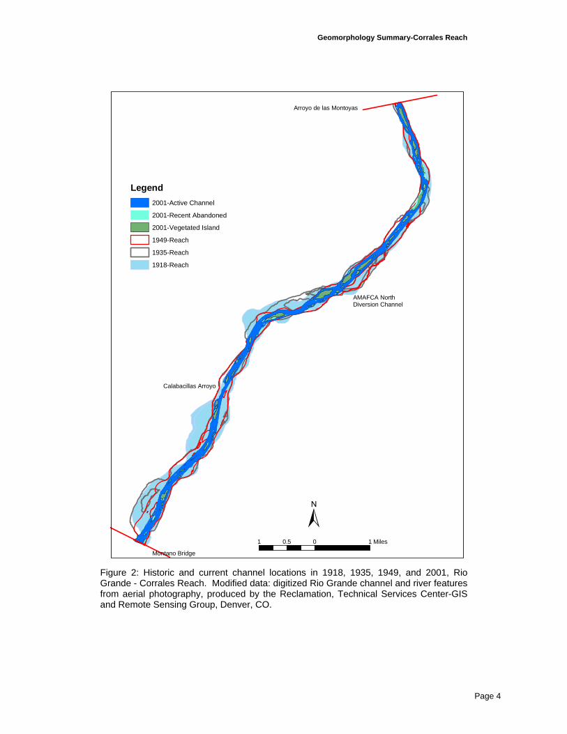
During rehabilitation of the Rio Grande in the 1930s by the Middle Rio Grande Conservancy District (MRGCD), a floodway was constructed along the river between 1930-1936 (Woodson and Martin 1962). The constructed floodway was noticeably narrower than the original channel (Figure 2), while the general location of the river did not change significantly. Several bends were abandoned as well as several active side channels. An initial levee system was also constructed during this time period. By the 1950s, the Rio Grande occupied a wide shallow channel between the levees in which the river banks were poorly developed (Leopold 1994). At this time, the average level of the channel bed, especially in the Albuquerque area, was above the elevation of the floodplain located outside of the levees (Woodson and Martin 1962). Continued flooding outside the levees prompted the U.S. Congress in 1948 and 1950 to authorize additional river modifications to control sedimentation and flooding along the Rio Grande. As part of this authorization, the Rio Grande was re-channelized, Kellner jetty jack fields were placed along the floodway to control channel and deposition locations. An improved levee system was also built at this time.
Since major re-construction of the floodway, river maintenance activities on the Rio Grande have been localized. Verbally recited maintenance history indicates that floodway bed de-stabilization, wood debris removal, and vegetation mowing occurred throughout the middle Rio Grande until the early 1990s (C. Gorbach, pers. comm., December 2003). These activities centered on controlling island/bar growth and maintaining levee integrity rather than floodplain manipulation.
After the 1941 flooding, several flood and sediment control dams were built in the Rio Grande watershed; three dams were built on tributaries and one dam on the mainstem Rio Grande (Cochiti dam) which began operations in November 1973 (Lagasse 1980). Although all of the dams influence the Rio Grande, the Cochiti dam/reservoir effects are clearly the most visible in the flood and sedimentation records.
Page 3
Geomorphology Summary-Corrales Reach
Montano Bridge
Arroyo de las Montoyas
AMAFCA North Diversion Channel
Calabacillas Arroyo
1 0 10.5 Miles
±
Legend2001-Active Channel
2001-Recent Abandoned
2001-Vegetated Island
1949-Reach
1935-Reach
1918-Reach
Figure 2: Historic and current channel locations in 1918, 1935, 1949, and 2001, Rio Grande - Corrales Reach. Modified data: digitized Rio Grande channel and river features from aerial photography, produced by the Reclamation, Technical Services Center-GIS and Remote Sensing Group, Denver, CO.
Page 4

Geomorphology Summary-Corrales Reach
2.2 PRECIPITAITON, FLOW, AND SEDIMENT Precipitation data indicates that the yearly rainfall has generally been
elevated in the 1980s and 1990s in the Albuquerque area. At present, the yearly average precipitation is 10.5 in/yr at the Corrales climate gage, 1984-1999, and 8.7 in/yr at the Albuquerque Airport climate gage, 1931-1999 [Massong 2003 (a)]. The largest rainfall year on record for the Albuquerque area occurred in 1941, with just over 16 inches of precipitation at the Albuquerque Airport gage.
In conjunction with the high rainfall in 1941, the last major flood event occurred in 1941 [Massong 2003 (a)]. Although the 1941 event was large, over 20,000 cfs, the largest flow at the USGS Rio Grande gage at San Felipe was in 1937, peaking at just over 27,000 cfs. Partial peak data (Hydrosphere 2000) show that other than one peak in 1955, the 1941 event was the last large flow (>15,000 cfs) to pass the San Felipe gage. Prior to 1973, the 2-year recurring peak flow was estimated just over 10,000 cfs, however post-1973 data indicates a current peak flow of under 6,000 cfs [Massong 2003 (a), Mussetter 2003]. In fact, no flows greater than 10,000 cfs have passed San Felipe since 1967 (Figure 3). Despite the low peak flows, the average yearly volume of water doubled after 1978 from 700,000 acre-feet to approximately 1,400,000 acre-feet [Massong 2003 (a)]. The average yearly water volume decreased after 1987 to approximately 960,000 acre-feet, which is still nearly 150% more water than the years prior to 1978.
0
5000
10000
15000
20000
25000
30000
1895
1900
1905
1914
1921
1927
1932
1937
1942
1947
1952
1957
1962
1967
1972
1977
1982
1987
1992
1998
Water Year
Dis
char
ge (c
fs)
Rio Grande at OtowiRio Grande at San Felipe
Figure 3: Rio Grande pak discharge records measured upstream (Otowi gage) and downstream (San Felipe) of Cochiti dam; USGS Rio Grande gage data at Otowi Bridge (1895-1999) and San Felipe (1927-1999), [Massong 2003 (a)].
Along with the lower peak flow data, suspended sediment data indicates a decreasing sediment load from historic levels (Table 1). USGS Rio Grande
Page 5

Geomorphology Summary-Corrales Reach
suspended sediment records at Bernalillo/Albuquerque, San Acacia and San Marcial indicate that the whole Rio Grande transported higher levels of sediment prior to 1958 (Table 1, Reclamation 2003). Since 1958, the suspended sediment supply decreased, with a dramatic decrease since 1973. As Cochiti dam began operations in 1973, the decrease in suspended sediment after 1973 is likely due to the dam’s sediment trapping effectiveness. The average suspended sediment levels in the Albuquerque area is currently less than one million tons per year. Table 1: Average yearly amount of suspended sediment collected at the USGS Rio Grande gages at Albuquerque and Bernalillo, NM, [Massong 2003 (a)]. Time Period Average Suspended Sediment
(million tons/yr) 1956-1958 10.8 1958-1972 3.0 1972-1973 7.6 1973-1985 1.2 1985-1993 0.3
(1989-1992) (no data collected) 1993-1995 2.8 1995-1999 0.8
Combining both the discharge with the suspended sediment data shows that the 1980s produced flows with relatively low concentrations of sediment. Prior to 1973, sediment concentrations ranged from 3,700 to 6,700 mg/l (Albert et al. 2003) in the Albuquerque area; after 1973 the concentration decrease to about 1,600 mg/l until the 1978-1993 period which measured sediment concentrations less than 650 mg/l. In 1993-1995, sediment concentrations increased up to almost 1,500 mg/l before returning to about 650 mg/l in the later 1990s. The increase in sediment from 1993-1995 corresponds with increased thunderstorm activity found in the precipitation data [Massong 2003 (a)].
Page 6

Geomorphology Summary-Corrales Reach
3.0 WIDTH AND PLANFORM DISCUSSION
Historically, the unconfined channel of 1918-1935 had a channel width of approximately 1,200 feet, but had already narrowed noticeably by the 1949 photos (Albert et al. 2003). The active channel found today was re-shaped/channelized during the floodway rehabilitation in the 1950s by the MRGCD; through the use of Kellner jetty jacks, the channel width was set at approximately 660 feet. During this floodway re-construction, a continuous and improved levee system was built along with the installation of numerous lines of jetty jacks as erosion protection (Woodson 1961). Data after 1962 shows that a stable channel width of ~650 feet set-up, however, since 1992, narrowing has begun at approximately 5 ft/yr (Albert et al. 2003). In comparison, channel widths upstream in the Santa Ana reach also are not in equilibrium; the current Santa Ana reach width is approximately 330 feet and still narrowing (T. Bauer pers. Comm, December 2003 and Reclamation 1998). Since the channel bank locations appear unchanged in the Corrales reach, the decrease in channel width appears to be primarily due to island establishment and growth within the active channel.
Although island development is difficult to predict, continued narrowing is expected as the current un-vegetated bars grow. Islands became prominent feature in this reach starting in the mid-1980s (Ortiz 2003), as river flows and sediment declined (Figure 3 and Table 1). Historic photos indicate that islands naturally formed in this reach [Figure 2 and Massong (b)], but the floodway construction in the 1950s removed these islands, creating a more uniform channel. As channel maintenance activities appeared to focus on suppressing islands, once the disturbances subsided, island development quickly rebounded 1985-1992 (Figure 4); although new island development continues to date, the initially formed islands in the early 1990s rapidly expanded in the late 1990s. Without relatively peak flows high enough to scour the islands or maintenance activities that physically remove them, island growth and development will likely continue to decrease channel width/area and split flows.
The recent growth of the islands is a vital component to the evolution of the channel pattern. Aerial photos from 1949 show that although islands were present, the channel planform, was not greatly influenced by their presence (Figure 5); the 1949 islands are small and appear to be thickly vegetated. The planform in these photos appears to be a slightly sinuous meandering pattern with developed point bars on the inside of the channel bends. After the 1949 photos, channel pattern becomes less distinct but appears to be mostly braided. By the 1992 photos, the planform was bar-braided, which evolved into island-braided by the 2002 photos (Figure 5) as the 1992 bars vegetated.
Page 7

Geomorphology Summary-Corrales Reach
96
75
102
0
2000
4000
6000
8000
10000
12000
1972 1985 1992 2001
photo date
isla
nd a
rea
(m2 )
Figure 4: Total island area within the Rio Grande channel, Corrales reach; number of islands present in each photo year is printed above the column for each year. Modified data from Ortiz (2003).
A similar evolutionary pattern was also found immediately upstream of the Corrales reach in the Bernalillo Bridge reach [Massong 2003 (a)]. However, the upstream reach has evolved one step beyond this reach; the side channels have become abandoned, causing the islands to become bank attached. The side channel abandonment was at least partially attributed to continued degradation of the channel bed, which has not been a prominent process in the Corrales reach, to date. However, the full planform evolution, as seen in the Bernalillo Bridge reach, is expected in the Corrales reach, such that the planform will change into a single threaded channel as found upstream.
Page 8

Geomorphology Summary-Corrales Reach
´
0 0.25 0.50.125 Miles
1949 Photo
´
0 0.25 0.50.125 Miles
1972 Photo
´
0 0.25 0.50.125 Miles
1992 Photo
´
0 0.25 0.50.125 Miles
2001 Photo
Figure 5: Historical aerial photographs (1949, 1972, 1992, and 2001) of the Corrales area. Figure from Massong, 2003 (b).
Page 9
Geomorphology Summary-Corrales Reach
4.0 CHANNEL INCISION DISCUSSION Incision simply defined is the river eroding the channel bed. The post-
1972 channel bed has been slightly incising, however, recent deposition has occurred downstream of Arroyo Calabacillas (Figure 6). Based on cross section data, approximately 2-3 feet of incision has occurred upstream of Arroyo Calabacillas since 1972 (Albert et al. 2003). Field measurements of the historic floodplain (pre-1935 surface) just upstream of this reach indicates approximately 5 feet of incision (Ortiz 2003), collaborating with the degradation results presented by Albert et al.
Just downstream of Arroyo Calabacillas, the channel is filling slightly and has almost attained the 1962 surface at the Montano Blvd. bridge (Figure 6). Since this section of the river channel has similar slopes and physical channel dimensions to that found upstream of Arroyo Calabacillas, the deposition of sediments is likely due to an increase in local sediment supply, specifically an increase in sediment from the arroyo.
The change in channel pattern to island-braided causes the flow within the channel to focus into several small channels as it winds itself around the islands. This smaller flow area has a deeper channel depth [Albert et al. 2003, and Massong 2003(a)] than when it was simply braided or bar-braided. A deeper thalweg has more potential at transporting sediment, therefore the bed will become more unstable as the planform evolves. With this information, incision is expected to continue upstream of Arroyo Calabacillas and begin downstream of the arroyo until the channel bed stablizes.
Page 10

Geomorphology Summary-Corrales Reach
4960
4970
4980
4990
5000
5010
5020
5030
0 1 2 3 4 5 6 7 8 9 10 11
Distance downstream from Agg/Deg 351 (miles)
Mea
n B
ed E
leva
tion
(feet
)
1962 MBE1972 MBE1992 MBE2001 MBE
AMAFCA North Diversion
Arroyo del Las Calabacillas
Montano Bridge
Subreach 1 Subreach 2 Subreach 3
Figure 6: Longitudinal profile for the Rio Grande-Corrales reach. Figure re-printed from Albert et al. (2003).
Page 11

Geomorphology Summary-Corrales Reach
5.0 BED MATERIAL DISCUSSION Even though the bed material size has coarsened reach wide since Cochiti
dam began operations (Ortiz 2003), this reach still has a sand bed. The sediment transport model results show that sand-sized sediment is transported at nearly all flows >2,000 cfs [Massong 2003(b)], in fact, the only bed material that wasn’t predicted to be mobile were the cobbles just downstream from Arroyo de las Montoyas. Stable grain size model results also indicate that stable sediment at all the cross sections was at least gravel in size. These results indicate that without at least a gravel armour layer, the bed sediments are unstable.
Sources of gravel are limited to transport by the Rio Grande from the Bernalillo Bridge reach or transported into the Rio Grande by the two west-side tributaries. Unpublished data from Ortiz (pers. Comm. December 2003) indicates that the gravel bed transition is migrating downstream at a rate of approximately 1.33 miles per year. Since the transition zone is immediately upstream of this reach, gravel conversion is expected in the near future from this gravel sediment source alone.
Sediment from the two west-side tributaries is a mixture of sand, gravel and cobbles, however the actual amount of sediment delivery is unknown. At Arroyo de las Montoyas, a sediment settling structure collects much of the arroyo’s sediment prior to being transported to the Rio Grande channel; this settling basin is periodically emptied.
Sediment from Arroyo Calabacillas is directly transported to the Rio Grande channel and a relative amount of sediment can be assessed by monitoring the tributary confluence. Fan development at the Arroyo Calabacillas confluence began in the 1972 photos, but grew significantly in the 1980s and 1990s, with most of the growth 1985-1992 (Figure 7). This fan growth indicates that either the Rio Grande’s ability to completely transport arroyo sediment has diminished or there is an increase in arroyo sediments transported into the Rio Grande. In addition to an increase in arroyo sediment supply, an increase in the sediment size could also explain the obvious decrease in sediment transport at the confluence. Adequate information is not known about the arroyo sediment to exactly determine which process is facilitating the fan growth at Arroyo Calabacillas, but all three processes are likely having an influence on the fan’s growth.
Continued coarsening of the Rio Grande’s channel is expected in the Corrales reach. Due to the continued source of coarse sediment from Arroyo Calabacillas, the section downstream of this arroyo may coarsen first. Regardless of timing, the entire reach is expected to transition to a gravel bed.
Page 12

Geomorphology Summary-Corrales Reach
±
0 500 1,000250 Feet
LegendHistory of Arroyo Calabacillas
1949 Arroyo Calabacillas fan
1972 Arroyo Calabacillas fan
1992 Arroyo Calabacillas fan
2001 Arroyo Calabacillas fan
Figure 7: Alluvial fan at the Rio Grande-Arroyo Calabacillas confluence. Figure re-printed from Massong 2003 (b).
6.0 SUMMARY Although the transition zone has not yet reached the Corrales reach, it is
immediately upstream and is expected to continue to migrate through this area. If similar channel changes occur as found in the upstream reaches, the river will:
o Convert to a gravel bed throughout the reach;
o Continue to incise;
o Continue to abandon the use of the floodplain and vegetated island surfaces as overflow areas;
o Create a single-threaded channel;
o Narrow and deepen, especially in the thalweg;
The exact magnitude of these changes is very difficult to predict, since the exact constraints on the conversion are unknown; additional analysis should be performed after the conversion has begun. The transition appears to begin is small 2-4 mile sections rather than a steady downstream migrating conversion (i.e., Bernalillo Bridge reach). Conversion may also happen quickly over relatively long river-distances, stop for a ‘break’ when conditions are not adequate, then resume again when river conditions are better.
Page 13

Geomorphology Summary-Corrales Reach
7.0 LITERATURE CITED Albert, J., Sixta, M., Leon, C., and Julien, P., 2003, Corrales Reach, Corrales
Flood Channel to Montano Bridge, Hydraulic Modeling Analysis, 1962-2001, Middle Rio Grande, New Mexico, prepared for US Bureau of Reclamation, Albuquerque Area Office, Albuquerque NM, 97+ p.
Bureau of Reclamation, 1998, Draft Santa Ana-Phase I, Geomorphic Report, Technical Report, Upper Colorado Region, Albuquerque Area Office, Albuquerque NM, 21 p.
Bureau of Reclamation, 2003, Geomorphic Assessment of the Rio Grande, San Acacia Reach, June 2003, Technical Report, Upper Colorado Region, Albuquerque Area Office, Albuquerque NM, 78 p.
Lagasse, P. F., 1980, An Assessment of the Response of the Rio Grande to Dan Construction-Cochiti to Isleta, U. S. Army Corps of Engineers Technical Report, Albuquerque, NM, 133p.
Leopold, L. B., 1994, A View of the River, Cambridge, MA: Harvard University Press, 298 p.
Massong, T. M., 2003 (a), Geomorphology Summary, Rio Grande-Bernalillo Bridge Reach, unpublished Technical Report (draft), Bureau of Reclamation, Albuquerque, NM, 20 p.
Massong, T. M., 2003 (b), Current Geomorphic Conditions, Rio Grande-Corrales Reach, unpublished Technical Report (draft), Bureau of Reclamation, Albuquerque, NM, 25 p.
Mussetter Engineering Inc (MEI), 2002, Geomorphic and Sedimentologic Investigation of the Middle Rio Grande between Cochiti Dam and Elephant Butte Reservoir, prepared for the New Mexico Interstate Stream Commission, Mussetter Engineering Inc., Fort Collins, CO 80525.
Ortiz R. M., 2003, Preliminary Geomorphic Assessment of the Bernalillo-Albuquerque Reach, Middle Rio Grande near Albuquerque, New Mexico (draft), prepared for US Bureau of Reclamation, Department of Earth and Planetary Sciences, University of New Mexico, Albuquerque, New Mexico.
Woodson, R. C., and J. T. Martin, 1962, The Rio Grande comprehensive plan in New Mexico and its effects on the river regime through the middle valley, Control of Alluvial Rivers by Steel Jetties, American Society of Civil Engineering Proceedings, Waterways and Harbors Division Journal 88, E. J. Carlson and E. A. Dodge (eds.), NY, NY, pp. 53-81.
Page 14