rio tinto citadel farm-in project 2018 exploration update · 12/11/2018 · $60m staged farm‐in...
TRANSCRIPT

MEDIA RELEASE 11 December 2018
RIO TINTO CITADEL FARM-IN PROJECT 2018 EXPLORATION UPDATE
Highlights
Rio Tinto Exploration Pty Limited (“Rio Tinto”) has completed the following exploration activities at the Company’s Citadel Project where Rio Tinto can earn up to 75% by spending up to $60.0M:
Reverse circulation (“RC”) 2,052m drill programme testing several prospective copper-gold targets
Airborne electromagnetic (“AEM”) survey covering 600km2; and
Review of the Calibre and Magnum deposits which host gold-copper-silver±tungsten Mineral Resources
Limited RC drilling (3 holes for 378m) at the GT1 target identifies multiple strongly anomalous zones of copper, gold, silver, tungsten and zinc for priority follow-up
Calibre and Magnum review identifies significant resource extensional targets along strike and down dip at Calibre
AEM survey results pending
OVERVIEW
Antipa Minerals Ltd (ASX: AZY) (‘Antipa’, ‘the Company’) is pleased to provide an update for the 2018 exploration activities completed at the Citadel Project (the ‘Project’) as part of the $60M staged farm‐in by Rio Tinto Exploration Pty Limited (‘Rio Tinto’), a wholly owned subsidiary of Rio Tinto Limited. The Citadel Project is located in the prospective Paterson Province, 80km north of Newcrest’s Telfer gold‐copper‐silver mine in northern Western Australia (Figure 1). Under the existing terms of the farm‐in agreement, Rio Tinto continues to operate the Citadel Project.
Antipa’s Paterson Province dual exploration strategy strives to deliver both greenfield discoveries and increase brownfield gold and/or copper resources during 2019, exploration activities within the Citadel Project are complementary to this strategy.
DRILLING PROGRAMME
Rio Tinto completed a reverse circulation (“RC”) drill programme consisting of 12 holes for 2,052m testing three copper‐gold targets, key results are summarised below. Refer to Figure 1 for a plan summarising target and drill hole locations and Table 1 and Table 2 for drill hole assay results and collar details.
GT1 Target
The GT1 target is located 15km northwest of Folly in a favourable geological and structural setting within the El Paso Corridor (Figure 1). The target is supported by overlapping magnetic and historic GEOTEM electromagnetic conductivity anomalies. Just three, approximately vertical, RC holes were completed at GT1 (total 378m at an average depth of 126m), intersecting several zones of strongly anomalous mineralisation across maximum downhole intervals up to 38m, with maximum 1m grades for copper of 1,950 ppm, tungsten 6,690 ppm (0.7%), silver 1.39 g/t, gold 0.06 g/t, zinc 377 ppm and cobalt 172 ppm. Depth of cover ranges

between 12 to 36m. The geochemical signatures are consistent with an intrusion related hydrothermal system with follow‐up considered a priority and the results from the recently completed SkyTEM helicopter borne electromagnetic survey having the potential to refine the target location.
Folly Target Area
The Folly target area is hosted within the El Paso Corridor (Figure 1) and was supported by existing lithological, geochemical and geophysical data. Eight RC holes were completed at Folly (total 1,494m at an average depth of 187m), intersecting several zones of weak mineralisation across maximum downhole intervals up to 27m, with maximum 1m grades for copper of 1,565 ppm, silver 1.83 g/t, gold 0.04 g/t, tungsten 920 ppm and molybdenum 228 ppm. Depth of cover ranges between 3 to 45m. Whilst the geochemical signatures are consistent with an intrusion related hydrothermal system, at this stage no follow‐up is envisaged for Folly.
MB1 Target
The MB1 target is located 10km northeast of Folly (Figure 1) the available magnetic data supported a possible intrusion related or porphyry mineralisation target. A single RC hole (180m) was completed at MB1, intersecting an unaltered and unmineralised felsic intrusion. Depth of cover was 44m. No further follow‐up is warranted.
CITADEL PROJECT AND MAGNUM DOME REVIEW
Rio Tinto continues to review the wider Citadel Project area including the Magnum Dome for the identification of new targets. Rio Tinto’s review of the Calibre and Magnum deposits identified significant resource extensional targets along strike and down dip at the Calibre deposit. Activities which remain ongoing include:
Generation of a Magnum Dome structural model; and
Definition of additional RC and/or diamond drilling targets.
AERIAL ELECTROMAGNETIC SURVEY
The 600km2 airborne electromagnetic (SkyTEM) survey with the objective of defining EM conductors with potential to represent semi‐massive to massive sulphides associated with gold and/or copper mineralisation has been completed and results are pending. The survey area covered all remaining regions of the Citadel Project not previously covered by state of the art AEM geophysical systems (Figures 2 and 3). AEM has been an instrumental tool in several significant Paterson Province discoveries and this is the first geophysical survey of this type over this area. The AEM Survey was not included in the original Rio Tinto exploration programme and budget for this field season and represents a decision by Rio Tinto to undertake additional regional geophysical work in the current year, with the objective of generating targets that can be followed up and potentially tested in 2019.
ONGOING EXPLORATION ACTIVITIES AT THE CITADEL PROJECT
Aerial electromagnetic data processing, analysis and targeting;
2

Ongoing evaluation of exploration opportunities across the broader Citadel Project area, including the Calibre resource extensional targets; and
Planning for the 2019 exploration programme.
FARM-IN TERMS
The farm‐in agreement with Rio Tinto requires the following expenditure to be incurred (or paid) by Rio Tinto to earn up to a 75% joint venture interest in the Citadel Project:
$3 million exploration expenditure within 18 months of execution of the farm‐in agreement (execution date: 9 October 2015). This has now been satisfied. No joint venture interest was earned by the incurring of this amount.
$8 million exploration expenditure within a further 3 year period commencing 11 April 2017 to earn a 51% joint venture interest. Rio Tinto is in the second year of this stage.
$14 million exploration expenditure within a further 3 year period to earn a 65% joint venture interest. Antipa may elect to contribute at this point and maintain a 35% joint venture interest.
$35 million exploration expenditure within a further 3 year period to earn a 75% joint venture interest.
Rio Tinto has a right to withdraw from the farm‐in at the completion of each annual exploration programme.
Figure 1: Paterson Province magnetic plan showing the Citadel Project and proximal Antipa tenements
(“brighter” regions), the El Paso Corridor and deposit/prospect locations including Folly, GT1 and
MB1. NB: Over airborne magnetic image (Pseudo-colour First Vertical Derivative and typically a 50 to 100m flight-line
spacing at an altitude of 30m).
3

Figure 2: Plan view showing Antipa’s Paterson Province projects, the recently completed 600km2
Citadel Project SkyTEM survey area, the Minyari-WACA deposits and Mineral Resources, Newcrest
Mining Ltd’s Telfer Mine and O’Callaghans deposit, Greatland Gold plc’s Havieron deposit and Rio
Tinto’s Exploration Camp. NB: “Rio Tinto 100%” tenements includes several Rio Tinto exploration licence applications
which are not first in time. Regional GDA94 / MGA Zone 51 co-ordinates, 50km grid.
4
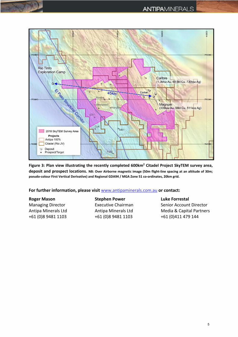
Figure 3: Plan view illustrating the recently completed 600km2 Citadel Project SkyTEM survey area,
deposit and prospect locations. NB: Over Airborne magnetic image (50m flight-line spacing at an altitude of 30m;
pseudo-colour First Vertical Derivative) and Regional GDA94 / MGA Zone 51 co-ordinates, 20km grid.
For further information, please visit www.antipaminerals.com.au or contact:
Roger Mason Managing Director Antipa Minerals Ltd +61 (0)8 9481 1103
Stephen Power Executive Chairman Antipa Minerals Ltd +61 (0)8 9481 1103
Luke Forrestal Senior Account Director Media & Capital Partners +61 (0)411 479 144
5

About Antipa Minerals:
Antipa Minerals Ltd is an Australian public company which was formed with the objective of identifying under‐explored mineral projects in mineral provinces which have the potential to host world‐class mineral deposits, thereby offering high leverage exploration and development potential. The Company owns 5,785km2 of tenements in the Paterson Province of Western Australia, including a 1,335km2 package of prospective granted tenements known as the Citadel Project. The Citadel Project is located approximately 75km north of Newcrest’s Telfer Gold‐Copper‐Silver Mine and includes the gold‐copper‐silver±tungsten Mineral Resources at the Calibre and Magnum deposits and high‐grade polymetallic Corker deposit. Under the terms of a Farm‐in and Joint Venture Agreement with Rio Tinto Exploration Pty Limited (“Rio Tinto”), a wholly owned subsidiary of Rio Tinto Limited, Rio Tinto can fund up to $60 million of exploration expenditure to earn up to a 75% interest in Antipa’s Citadel Project.
The Company has an additional 1,310km2 of granted exploration licences, known as the North Telfer Project which hosts the high‐grade gold‐copper Minyari and WACA Mineral Resources and extends its ground holding in the Paterson Province to within 20km of the Telfer Gold‐Copper‐Silver Mine and 30km of the O’Callaghans tungsten and base metal deposit. The Company has also acquired, from the Mark Creasy controlled company Kitchener Resources Pty Ltd, additional exploration licences in the Paterson Province which cover 831km2 and the Company owns a further 312km2 of exploration licences (including both granted tenements and applications), which combined are known as the Paterson Project, which comes to within 3km of the Telfer Mine and 5km of the O’Callaghans deposit.
6
Competent Persons Statement – Exploration Results:
The information in this report that relates to the Exploration Results is based on and fairly represents information and supporting documentation compiled by Mr Roger Mason, a Competent Person who is a Member of The Australasian Institute of Mining and Metallurgy. Mr Mason is a full‐time employee of the Company. Mr Mason is the Managing Director of Antipa Minerals Limited, is a substantial shareholder of the Company and is an option holder of the Company. Mr Mason has sufficient experience relevant to the style of mineralisation and type of deposit under consideration and to the activity being undertaking to qualify as a Competent Person as defined in the 2012 Edition of the ‘Australasian Code for Reporting of Exploration Results, Mineral Resources and Ore Reserves’. Mr Mason consents to the inclusion in the report of the matters based on his information in the form and context in which it appears.
Various information in this report which relates to Citadel Project Exploration Results have been extracted from the following announcements:
Report entitled “Calibre and Magnum Mineral Resources JORC 2012 Updates” created on 23 February 2015;
Report entitled “Rio Tinto – Antipa Citadel Project Joint Venture” created on 9 October 2015;
Report entitled “Rio Tinto Elects to Proceed to Stage 2 of Citadel Farm‐In” created on 12 April 2017;
Report entitled “Citadel Project 2017 Exploration Programme Update” created on 8 November 2017;
Report entitled “Calibre Deposit Mineral Resource Update” created on 17 November 2017;
Report entitled “Citadel Project 2018 Exploration Programme” created on 27 March 2018;
Report entitled “Presentation – Diggers and Dealers Conference Revised” created on 6 August 2018;
Report entitled “Rio Tinto Resumes Drilling at the Citadel Farm‐in Project” created on 4 September 2018;
Report entitled “Corporate Presentation – Hong Kong 121 Conference” created on 23 October 2018; and
Report entitled “Citadel Project Rio JV – Additional AEM Survey” created on 20 November 2018.
All of which are available to view on www.antipaminerals.com.au and www.asx.com.au. The company confirms that it is not aware of any new information or data that materially affects the information included in the original market announcements.
Forward-Looking Statements:
This document may include forward‐looking statements. Forward‐looking statements include, but are not limited to, statements concerning Antipa Mineral Ltd’s planned exploration programme and other statements that are not historical facts. When used in this document, the words such as "could," "plan," "estimate," "expect," "intend," "may," "potential," "should," and similar expressions are forward‐looking statements. Although Antipa Minerals Ltd believes that its expectations reflected in these forward‐looking statements are reasonable, such statements involve risks and uncertainties and no assurance can be given that actual results will be consistent with these forward‐looking statements.
7

Table 1: Citadel Project 2018 Reverse Circulation Drill Hole Key Assay Results
Copper‐Gold‐Silver‐Tungsten‐Zinc‐Cobalt‐Molybdenum (i.e. ≥ 1.0m with Cu ≥ 300ppm &/or Au ≥ 0.03ppm &/or Ag ≥ 0.30ppm &/or W ≥ 200ppm &/or Zn ≥ 250ppm &/or Co ≥ 100ppm &/or Mo ≥ 100ppm)
Hole ID Target From (m)
To (m)
Interval (m)
Cu (ppm)
Au (ppm)
Ag (ppm)
W (ppm)
Zn (ppm)
Co (ppm)
Mo (ppm)
18ACC0105 GT1 122.0 123.0 1.0 170 0.004 0.05 210 88 58 1 18ACC0105 GT1 123.0 124.0 1.0 165 0.003 0.04 250 81 59 1 18ACC0105 GT1 127.0 128.0 1.0 56 0.002 0.03 360 80 61 118ACC0106 GT1 21.0 22.0 1.0 4 0.051 0.01 2 3 7 0 18ACC0106 GT1 22.0 23.0 1.0 7 0.033 0.01 14 5 6 1 18ACC0106 GT1 40.0 41.0 1.0 496 0.008 0.05 4 117 40 2 18ACC0106 GT1 41.0 42.0 1.0 937 0.010 0.07 5 143 77 2 18ACC0106 GT1 42.0 43.0 1.0 301 0.005 0.05 3 124 48 118ACC0106 GT1 43.0 44.0 1.0 526 0.006 0.12 8 126 45 1 18ACC0106 GT1 44.0 45.0 1.0 1,540 0.007 0.33 10 155 41 1 18ACC0106 GT1 45.0 46.0 1.0 482 0.004 0.14 3 138 55 1 18ACC0106 GT1 60.0 61.0 1.0 548 0.008 0.12 5 139 55 118ACC0106 GT1 61.0 62.0 1.0 1,160 0.011 0.27 7 159 72 3 18ACC0106 GT1 62.0 63.0 1.0 951 0.007 0.52 66 122 41 2 18ACC0106 GT1 63.0 64.0 1.0 710 0.023 0.28 10 160 44 3 18ACC0106 GT1 95.0 96.0 1.0 468 0.003 0.28 2 220 51 218ACC0106 GT1 102.0 103.0 1.0 158 0.005 0.06 2 284 52 0 18ACC0106 GT1 121.0 122.0 1.0 449 0.009 0.14 6 150 54 1 18ACC0106 GT1 122.0 123.0 1.0 385 0.008 0.09 6 154 58 1 18ACC0106 GT1 123.0 124.0 1.0 388 0.010 0.08 6 135 54 118ACC0106 GT1 124.0 125.0 1.0 313 0.006 0.09 3 137 53 1 18ACC0107 GT1 32.0 33.0 1.0 55 0.001 0.47 9 41 16 0 18ACC0107 GT1 33.0 34.0 1.0 199 0.000 0.47 5 121 19 0 18ACC0107 GT1 34.0 35.0 1.0 305 0.000 0.31 5 195 35 118ACC0107 GT1 35.0 36.0 1.0 994 0.001 0.19 2 375 68 1 18ACC0107 GT1 36.0 37.0 1.0 429 0.001 0.10 2 348 56 1 18ACC0107 GT1 37.0 38.0 1.0 358 0.003 0.15 2 313 60 1 18ACC0107 GT1 38.0 39.0 1.0 270 0.002 0.15 5 287 58 118ACC0107 GT1 41.0 42.0 1.0 218 0.007 0.17 6 282 88 1 18ACC0107 GT1 42.0 43.0 1.0 459 0.004 0.13 8 268 96 1 18ACC0107 GT1 43.0 44.0 1.0 429 0.003 0.16 9 377 86 1 18ACC0107 GT1 45.0 46.0 1.0 303 0.004 0.08 7 156 68 1 18ACC0107 GT1 53.0 54.0 1.0 231 0.031 0.08 3 113 49 118ACC0107 GT1 57.0 58.0 1.0 355 0.007 0.12 4 117 50 1 18ACC0107 GT1 62.0 63.0 1.0 302 0.008 0.23 3,710 148 64 6 18ACC0107 GT1 63.0 64.0 1.0 808 0.060 0.61 6,690 327 88 21 18ACC0107 GT1 64.0 65.0 1.0 1,950 0.045 1.39 660 328 173 318ACC0107 GT1 65.0 66.0 1.0 373 0.007 0.21 750 185 65 2 18ACC0107 GT1 67.0 68.0 1.0 774 0.003 0.43 17 136 54 2 18ACC0107 GT1 68.0 69.0 1.0 318 0.004 0.16 22 123 53 1 18ACC0097 Folly 5.0 6.0 1.0 238 0.004 0.03 1 108 153 218ACC0097 Folly 6.0 7.0 1.0 292 0.005 0.04 1 116 739 2 18ACC0097 Folly 154.0 155.0 1.0 169 0.003 0.78 4 101 28 3 18ACC0098 Folly 62.0 63.0 1.0 325 0.004 0.10 3 80 43 35 18ACC0098 Folly 63.0 64.0 1.0 435 0.006 0.09 3 78 45 218ACC0098 Folly 66.0 67.0 1.0 102 0.001 0.19 3 183 45 228 18ACC0098 Folly 70.0 71.0 1.0 320 0.003 0.14 3 85 44 55 18ACC0098 Folly 71.0 72.0 1.0 293 0.002 0.11 4 59 29 160 18ACC0098 Folly 97.0 98.0 1.0 333 0.002 0.09 1 136 51 618ACC0098 Folly 177.0 178.0 1.0 99 0.001 1.83 15 90 14 29 18ACC0098 Folly 189.0 190.0 1.0 12 0.002 0.02 380 64 12 15 18ACC0098 Folly 202.0 203.0 1.0 15 0.001 0.01 920 73 78 3 18ACC0099 Folly 16.0 17.0 1.0 47 0.001 0.07 5 133 115 118ACC0099 Folly 62.0 63.0 1.0 59 0.001 0.17 2 39 8 105 18ACC0100 Folly 93.0 94.0 1.0 613 0.018 0.15 2 20 14 4 18ACC0100 Folly 94.0 95.0 1.0 1,565 0.027 0.13 2 32 24 3 18ACC0100 Folly 95.0 96.0 1.0 529 0.016 0.06 2 19 8 7 18ACC0100 Folly 107.0 108.0 1.0 552 0.014 0.23 3 20 10 418ACC0100 Folly 108.0 109.0 1.0 442 0.033 0.09 2 15 8 4 18ACC0100 Folly 113.0 114.0 1.0 533 0.015 0.10 4 13 4 4 18ACC0100 Folly 132.0 133.0 1.0 399 0.011 0.27 5 56 10 5 18ACC0101 Folly 71.0 72.0 1.0 305 0.006 0.11 3 119 47 218ACC0101 Folly 72.0 73.0 1.0 318 0.006 0.10 2 130 48 2 18ACC0101 Folly 73.0 74.0 1.0 310 0.008 0.09 2 126 48 3 18ACC0101 Folly 75.0 76.0 1.0 460 0.006 0.16 3 120 50 3 18ACC0101 Folly 76.0 77.0 1.0 335 0.007 0.11 2 112 49 218ACC0101 Folly 78.0 79.0 1.0 371 0.007 0.08 2 89 42 2
8

Hole ID Target From (m)
To (m)
Interval (m)
Cu (ppm)
Au (ppm)
Ag (ppm)
W (ppm)
Zn (ppm)
Co (ppm)
Mo (ppm)
18ACC0101 Folly 79.0 80.0 1.0 716 0.013 0.13 3 78 39 2 18ACC0101 Folly 80.0 81.0 1.0 340 0.007 0.07 2 91 47 118ACC0101 Folly 100.0 101.0 1.0 317 0.003 0.14 3 96 57 3 18ACC0103 Folly 48.0 49.0 1.0 23 0.038 0.12 5 68 11 1 18ACC0103 Folly 114.0 115.0 1.0 321 0.001 0.14 4 69 21 6 18ACC0104 Folly 119.0 120.0 1.0 30 0.033 0.04 3 74 15 118ACC0104 Folly 136.0 137.0 1.0 5 0.000 0.02 450 8 33 2 18ACC0104 Folly 179.0 180.0 1.0 19 0.003 0.02 220 20 20 3 18ACC0104 Folly 187.0 188.0 1.0 56 0.004 0.05 230 18 20 5
Notes (Intersection Table above): The intervals/intersections listed above have not been composited from individual assays as due to the reconnaissance nature of the 2018 Reverse Circulation drill programme varying sample lengths are present. The following selection criteria apply:
Intersection Interval = Nominal cut‐off grade scenarios:
≥ 300ppm (or 0.03%) copper which also satisfy a minimum down‐hole interval of 1.0m; or
≥ 0.03ppm gold which also satisfy a minimum down‐hole interval of 1.0m; or
≥ 0.30ppm silver which also satisfy a minimum down‐hole hole interval of 1.0m.
≥ 200ppm (or 0.02%) tungsten which also satisfy a minimum down‐hole interval of 1.0m; or
≥ 250ppm (or 0.025%) zinc which also satisfy a minimum down‐hole interval of 1.0m; or
≥ 100ppm (or 0.01%) cobalt which also satisfy a minimum down‐hole interval of 1.0m; or
≥ 100ppm (or 0.01%) molybdenum which also satisfy a minimum down‐hole interval of 1.0m.
NB: In some instances, zones grading less than the cut‐off grade/s have been included to highlight mineralisation trends.
NB: For the purpose of highlighting significant (generally isolated) results some intersections may be included in the Table above which do not satisfy the criteria above.
No top‐cutting has been applied to the assay results tabulated above;
Intersection true widths are unknown and would vary depending on the angle at which each individual drill hole intersects any mineralisation domains.
Intersections are down hole lengths, true widths not known with certainty.
Table 2: Citadel Project – 2018 RC Drill Hole Collar Locations (MGA Zone 51/GDA 94)
Hole ID Target Area Northing
(m) Easting (m)
RL (m) Hole Depth (m)
Azimuth (°)
Dip (°)
Assay Status
18ACC0097 Folly 7,676,400 397,200 270 210 228 ‐70 Received
18ACC0098 Folly 7,676,400 397,200 270 276 45 ‐70 Received
18ACC0099 Folly 7,676,050 397,403 272 204 43 ‐70 Received
18ACC0100 Folly 7,675,583 398,059 285 198 50 ‐61 Received
18ACC0101 Folly 7,677,296 395,588 264 144 45 ‐70 Received
18ACC0102 Folly 7,677,704 395,426 257 96 45 ‐70 Received
18ACC0103 Folly 7,676,196 397,539 281 156 46 ‐61 Received
18ACC0104 Folly 7,675,438 397,924 289 210 43 ‐61 Received
18ACC0105 GT1 7,693,027 389,138 261 138 51 ‐81 Received
18ACC0106 GT1 7,692,507 389,450 264 150 119 ‐90 Received
18ACC0107 GT1 7,692,884 389,276 265 90 126 ‐90 Received
18ACC0108 MB1 7,687,107 400,320 287 180 62 ‐89 Received
9

CITADEL PROJECT Section 1 – Sampling Techniques and Data (Criteria in this section shall apply to all succeeding sections)
Criteria JORC Code explanation Commentary
Sampling techniques
Nature and quality of sampling (e.g. cut channels, random chips, or specific specialised industry standard measurement tools appropriate to the minerals under investigation, such as down hole gamma sondes, or handheld XRF instruments, etc). These examples should not be taken as limiting the broad meaning of sampling.
Include reference to measures taken to ensure sample representivity and the appropriate calibration of any measurement tools or systems used.
Aspects of the determination of mineralisation that are Material to the Public Report.
In cases where ‘industry standard’ work has been done this would be relatively simple (e.g. ‘reverse circulation drilling was used to obtain 1 m samples from which 3 kg was pulverised to produce a 30 g charge for fire assay’). In other cases more explanation may be required, such as where there is coarse gold that has inherent sampling problems. Unusual commodities or mineralisation types (e.g. submarine nodules) may warrant disclosure of detailed information.
Sampling via RC Drilling
12 Reverse Circulation (RC) drill holes were completed, totalling 2,052m with an average drill hole
depth of 171m, to obtain samples for assay for a broad range of elements using standard acid digest,
spectroscopy, spectrometry and fire assay techniques.
The drilling programme was overseen by Rio Tinto Exploration Pty Limited (“RTX”), who are farming in
to the Citadel Project.
Assays have been received for all of the 12 completed RC drill holes.
The drilling programme investigated a number of targets including:
- Folly
- GT1
- MB1
RC Sampling:
RC Sampling was carried out under RTX protocols (consistent with Antipa protocols) and QAQC
procedures as per industry best practice.
RC samples were drilled using a 140mm diameter face sampling hammer and sampled on intervals of
1.0m using a rig mounted cone splitter from which 3 kg (average) samples were produced which were
then pulverised at the laboratory to produce material for assay.
Drilling techniques
Drill type (e.g. core, reverse circulation, open‐hole hammer, rotary air blast, auger, Bangka, sonic, etc) and details (e.g. core diameter, triple or standard tube, depth of diamond tails, face‐sampling bit or other type, whether core is oriented and if so, by what method, etc).
RC Drilling
A total of 12 RC drill holes were drilled totalling 2,052m with average drill hole depth of 171m.
All drill holes were completed using 140mm RC face sampling hammer drill bit from surface to total
drill hole depths of between 90m and 276m
Due to the range of different targets and expected geology being tested, and in some cases the
drilling conditions, drill holes were a mixture of vertical holes and holes directed towards the SW
(225° Magnetic) or NE (043° Magnetic). Drill holes had an inclination angle of ‐60 to ‐90 at the collar
to optimally intersect the expected target geology.
Drill sample recovery
Method of recording and assessing core and chip sample recoveries and results assessed.
Measures taken to maximise sample recovery and ensure representative nature of the samples.
Whether a relationship exists between sample recovery and grade and whether sample bias may have occurred due to preferential loss/gain of fine/coarse material.
RC Drill Samples
RC sample recovery was via visual estimation of sample volume and marked as poor (<70% recovery)
or good (70% ‐ 100%).
RC sample recovery ranges from poor to good with only very occasional samples with poor recovery
RC sample recovery was maximized by endeavouring to maintain dry drilling conditions as much as
practicable; the RC samples were almost exclusively dry
All samples were split on a 1m interval using a rig‐mounted cone splitter. Adjustments were made to
10

Criteria JORC Code explanation Commentary
ensure representative 2 kg to 3 kg sample volumes were collected.
Relationships between recovery and grade are not evident and are not expected given the generally
excellent and consistently high sample recovery
RC sample recovery and sample quality was recorded via visual estimation of sample volume and
condition of drill spoils.
RC results are generated for the purpose of exploration and potentially for Mineral Resource
estimations
Logging Whether core and chip samples have been geologically and geotechnically logged to a level of detail to support appropriate Mineral Resource estimation, mining studies and metallurgical studies.
Whether logging is qualitative or quantitative in nature. Core (or costean, channel, etc) photography.
The total length and percentage of the relevant intersections logged.
RC Drill Logging
All RC material is logged.
Logging includes both qualitative and quantitative components.
All logging is entered directly into a Toughbook computer using a logging system which is based in
AcQuire. Further validation is carried out during upload to the RTX / Antipa Citadel Project farm‐in
master Acquire database.
Geological logging of 100% of all RC sample intervals was carried out recording colour, weathering,
lithology, mineralogy, alteration, veining and sulphides.
Selected RC sample intervals were measured for magnetic susceptibility using a handheld Magnetic
Susceptibility meter.
RC samples are generally analysed in the field using a Portable XRF Device (Olympus) for the
purposes of geochemical and lithological interpretation.
Sub‐sampling techniques and sample preparation
If core, whether cut or sawn and whether quarter, half or all core taken.
If non‐core, whether riffled, tube sampled, rotary split, etc and whether sampled wet or dry.
For all sample types, the nature, quality and appropriateness of the sample preparation technique.
Quality control procedures adopted for all sub‐sampling stages to maximise representivity of samples.
Measures taken to ensure that the sampling is representative of the in situ material collected, including for instance results for field duplicate/second‐half sampling.
Whether sample sizes are appropriate to the grain size of the material being sampled.
RC Samples
RC samples for all drill holes were drilled using a 140mm diameter face sampling hammer and split
on intervals of 1.0m using a rig mounted cone splitter from which a 3 kg (average) sample which was
pulverised at the laboratory to produce material for assay.
Field duplicate samples were collected for all RC drill holes
Sample preparation
Sample preparation of samples was completed at ALS Laboratory Group in Perth following industry
best practice in sample preparation involving oven drying, coarse crushing of the sample using a
primary crusher down to crushed size of approximately 70% passing 2mm, followed by pulverisation
of a rotary split 1 kg aliquot to a grind size of approximately 85% passing 75 µm via a ring mill
pulveriser using a carbon steel ring set. The pulverised sample is then further split into a sub–
sample/s for analysis.
The sample sizes are considered appropriate to suitably represent sample material derived from this
type of reconnaissance (geochemical) drill‐based exploration programme.
11

Criteria JORC Code explanation Commentary
Quality of assay data and laboratory tests
The nature, quality and appropriateness of the assaying and laboratory procedures used and whether the technique is considered partial or total.
For geophysical tools, spectrometers, handheld XRF instruments, etc, the parameters used in determining the analysis including instrument make and model, reading times, calibrations factors applied and their derivation, etc.
Nature of quality control procedures adopted (e.g. standards, blanks, duplicates, external laboratory checks) and whether acceptable levels of accuracy (i.e. lack of bias) and precision have been established.
The sample preparation technique for RC samples is documented by RTX’s standard procedures
documents and is in line with industry standards in sample preparation.
The sample sizes are considered appropriate to represent mineralisation.
Sample preparation checks for fineness were carried out by the laboratory as part of its internal
procedures.
Analytical Techniques:
All samples were dried, crushed, pulverised and split to produce a sub–sample for a
0.25g sample which are digested and refluxed with hydrofluoric, nitric, hydrochloric
and perchloric acids (“four acid digest”) suitable for silica based samples. This digest is
considered to approach a total dissolution for most minerals. Analytical methods used
were Inductively Coupled Plasma Atomic Emission Spectroscopy / Mass Spectrometry
(ICP–AES / ICP‐MS) for Ag, Al, As, Au, Ba, Be, Bi, Ca, Cd, Ce, Co, Cr, Cs, Cu, Fe, Ga, Ge,
Hf, In, K, La, Li, Mg, Mn, Mo, Na, Nb, Ni, P, Pb, Pd, Pt, Rb, Re, S, Sb, Sc, Sn, Sr, Ta, Te,
Th, Ti, Tl, U, V, W, Y, Zn and Zr.
Note that based on the analytical technique described above, the assay results for Au,
Pd and Pt are considered semi‐quantitative in nature and with the Au results being
determined from only 0.25g of material dissolved sample material they must be
treated with caution. The Au, Pd and Pt data are obtained by this method for the
purposes of identifying low level geochemical anomalism.
A lead collection Fire Assay on a 50g sample with Inductively Coupled Plasma Atomic
Absorption Spectroscopy (ICP‐AAS) undertaken to determine gold content with a
detection limit of 0.005ppm (for selected mineralised samples).
Ore grade ICP‐AES analysis was completed on samples returning results above upper
detection limit
No geophysical tools were used to determine any element concentrations in this
report.
A handheld portable XRF analyser (Olympus) device is used in the field to investigate
and record geochemical data for internal analysis. However, due to “spatial”
accuracy/repeatability issues this data is not publicly reported.
Field QC procedures involve the use of commercial certified reference material
(CRM’s) for assay standards and blanks. Standards/blanks are inserted at a rate of 5
per 100 samples. The grade of the inserted standard is not revealed to the laboratory.
Field duplicates/repeat QC samples were utilised during the RC drilling programmes at
a rate of 5 per 100 samples.
Inter laboratory cross‐checks analysis programmes have not been conducted at this
stage.
In addition to RTX supplied CRM’s, ALS Laboratory Group includes in each sample
batch assayed certified reference materials, blanks and up to 10% replicates.
12

Criteria JORC Code explanation Commentary
Selected anomalous samples are re‐digested and analysed to confirm results.
Verification of sampling and assaying
The verification of significant intersections by either independent or alternative company personnel.
The use of twinned holes.
Documentation of primary data, data entry procedures, data verification, data storage (physical and electronic) protocols.
Discuss any adjustment to assay data.
No significant intersections were encountered in the 2018 RC drilling
For the RC programme all logging is entered directly into a Toughbook computer using a logging
system which is based in AcQuire. Further validation is carried out during upload to RTX / Antipa’s
Citadel Project Farm‐in Acquire database.
No adjustments or calibrations have been made to any assay data collected.
Location of data points
Accuracy and quality of surveys used to locate drill holes (collar and down‐hole surveys), trenches, mine workings and other locations used in Mineral Resource estimation.
Specification of the grid system used.
Quality and adequacy of topographic control.
km = kilometre; m = metre; mm = millimetre.
Drill hole collar locations are surveyed using a handheld Garmin Montana GPS which has an accuracy
of ± 3m.
The drilling co‐ordinates are all in GDA94 MGA Zone 51 co‐ordinates.
RTX did not adopt or reference any specific local grid/s across the Citadel Project during this 2018
drilling Programme.
The topographic surface has been defaulted to 265m RL.
The topographic surface has been compiled using the drill hole collar coordinates.
Data spacing and distribution
Data spacing for reporting of Exploration Results.
Whether the data spacing and distribution is sufficient to establish the degree of geological and grade continuity appropriate for the Mineral Resource and Ore Reserve estimation procedure(s) and classifications applied.
Whether sample compositing has been applied.
RC Drilling
All RC drill holes were reconnaissance in nature and so a nominal drill spacing is not relevant.
Due to difficult drilling at GT1, 2 of the RC drill holes were vertical. The single hole at MB1 was drilled
vertical due to expected geology.
Other drill holes at GT1 and Folly were all inclined between ‐60 to ‐70 to optimally intersect the
mapped stratigraphy and quartz veining.
Orientation of data in relation to geological structure
Whether the orientation of sampling achieves unbiased sampling of possible structures and the extent to which this is known, considering the deposit type.
If the relationship between the drilling orientation and the orientation of key mineralised structures is considered to have introduced a sampling bias, this should be assessed and reported if material.
RC Drilling
At this stage, it cannot be determined with any certainty if any consistent and/or material bias exists
in the 2018 RC drill hole sampling as a result of the drill hole location and/or orientation in relation to
possible mineralised structures.
The location and orientation of the RC drilling is appropriate given the expected strike, dip and
morphology of the target geological structures.
Sample security The measures taken to ensure sample security. Chain of sample custody is managed by RTX to ensure appropriate levels of sample security.
Samples are stored on site and delivered by RTX or their representatives to Port Hedland and
subsequently by Toll to the assay laboratory in Perth.
Audits or reviews The results of any audits or reviews of sampling techniques and data.
Sampling techniques and procedures are regularly reviewed internally, as is the data.
13

CITADEL PROJECT Section 2 – Reporting of Exploration Results (Criteria listed in the preceding section also apply to this section)
Criteria JORC Code explanation Commentary
Mineral tenement and land tenure status
Type, reference name/number, location and ownership including agreements or material issues with third parties such as joint ventures, partnerships, overriding royalties, native title interests, historical sites, wilderness or national park and environmental settings.
The security of the tenure held at the time of reporting along with any known impediments to obtaining a licence to operate in the area.
The drilling is located wholly within granted Exploration Licenses E45/4561 and E45/2876.
Antipa currently has a 100% interest in all Citadel Project tenements, including E45/4561 and
E45/2876, and there are no royalties on these tenements.
On 9 October 2015, Farm‐in and JV Agreements were executed between Antipa and RTX.
E45/4561 and E45/2876 is contained completely within land where the Martu People have been
determined to hold Native Title rights. No historical or environmentally sensitive sites have been
identified in the area of work.
The tenements are in ‘good standing’ with the Western Australian DMIRS.
No known impediments exist, including to obtain a licence to operate in the area.
Exploration done by other parties
Acknowledgment and appraisal of exploration by other parties.
Citadel Project:
Prior to 1991 limited to no mineral exploration activities.
1991 to 1996 BHP Australia completed various regional airborne geophysical surveys (e.g.
aeromagnetics, radiometrics, GeoTEM, ground magnetics, surface EM), geochemical Air Core and
selected diamond drilling programmes across a significant area which covered the Citadel Project.
Whilst this era of exploration highlighted a number of areas as being variously anomalous, BHP did
not locate any basement (Proterozoic) precious or base metal mineralisation. In 1995 BHP Minerals
completed an MMI‐A/MMI‐B soil programme over an area which was ultimately found to be the
region within which the Magnum deposit was located.
1997 to 2002 JV partners Croesus‐Gindalbie completed minor surface geophysical surveys (e.g.
electromagnetics) and various drilling programmes across parts of the Citadel Project (i.e. 17 x
Diamond, 10 x RC and 134 x Air Core drill holes) leading to the discovery of the Magnum Au‐Cu‐Ag
deposit, and its partial delineation, in 1998.
2002 to 2003 JV partners Teck Cominco and Croesus‐Gindalbie completed detailed aeromagnetic
and radiometric surveys over the entire Citadel Project, Pole‐Pole IP over 8 targets and limited
drilling (i.e. 4 x Diamond drill holes) within the Citadel Project.
2004 to 2005 JV partners NGM Resources and Croesus‐Gindalbie completed limited drilling (i.e. 3 x
Diamond drill holes) at selected Citadel Project prospects intersecting minor Au‐Cu‐Ag mineralisation
at the Colt prospect.
2006 to 2010 Glengarry Resources/Centaurus Metals undertook re‐processing of existing data and
re‐logging of some drill core. No drilling or geophysical surveys were undertaken, and so no new
exploration results were forthcoming.
2011 to 2015 Antipa Minerals Ltd exploration of the Citadel Project including both regional and
prospect/area scale geophysical surveys (i.e. VTEM, ground EM, DHEM, ground magnetics and
ground gravity) and geochemical surveys (i.e. MMI‐M™ and SGH™ soil programmes) and drilling
programmes (i.e. diamond and RC) resulting in two greenfield discoveries in 2012, i.e. Calibre and
14

Criteria JORC Code explanation Commentary
Corker, and subsequent drilling programmes.
October 2015 to March 2017 Antipa Minerals Ltd operators under a Farm‐in Agreement executed on
the 9 October 2015 between Antipa and RTX, a wholly owned subsidiary of Rio Tinto Limited. RC
drilling at Calibre late 2015, and in 2016 an extensive IP survey, a regional target RC drilling
programme and single (deep) diamond drill hole were completed.
In 2017 RTX became operators under the Farm‐in Agreement (see above). During 2017, a further
extensive IP survey in the south‐eastern portion of E45/2877, an Air Core drilling Programme in the
central region (Rimfire area) of E45/2876, an aerial electromagnetic survey primarily over E45/4561,
an RC drilling Programme in the central region (Rimfire area) of E45/2876 and an RC drilling
programme at the Calibre Deposit within E45/2877 have been completed.
Geology Deposit type, geological setting and style of mineralisation. The geological setting is Paterson Province Proterozoic aged meta‐sediment hosted hydrothermal
shear, fault and strata/contact controlled precious and/or base metal mineralisation which is
typically sulphide bearing. The mineralisation in the region is interpreted to be granite related. The
Paterson is a low grade metamorphic terrane but local hydrothermal alteration and/or contact
metamorphic mineral assemblages and styles are indicative of a high‐temperature local
environment. Mineralisation styles include vein, stockwork, breccia and skarns.
Drill hole Information
A summary of all information material to the understanding of the exploration results including a tabulation of the following information for all Material drill holes:
easting and northing of the drill hole collar
elevation or RL (Reduced Level – elevation above sea level in metres) of the drill hole collar
dip and azimuth of the hole
down hole length and interception depth
hole length.
If the exclusion of this information is justified on the basis that the information is not Material and this exclusion does not detract from the understanding of the report, the Competent Person should clearly explain why this is the case.
All meaningful and material Citadel Project exploration information has been included in the body of
the text or can sometimes be found in previous public reports and various WA DMIRS (WAMEX)
publicly available reports.
Data aggregation methods
In reporting Exploration Results, weighting averaging techniques, maximum and/or minimum grade truncations (e.g. cutting of high grades) and cut‐off grades are usually Material and should be stated.
Where aggregate intercepts incorporate short lengths of high grade results and longer lengths of low grade results, the procedure used for such aggregation should be stated and some typical examples of such aggregations should be shown in detail.
The assumptions used for any reporting of metal equivalent values should be clearly stated.
Reported aggregated length intervals have been length weighted.
No density or bulk density is available and so no density weighting has been applied when calculating
aggregated intervals.
No top‐cuts to gold or copper have been applied (unless specified otherwise).
Intersections in this report are composited for the purposes of highlighting geochemical
anomalism/trends from individual assays using the criteria below which are considered relevant for
both the reconnaissance nature of the drilling programme and metal indicators for various known
mineralisation styles within the Paterson Province.
For the RC drilling results a nominal cut‐off grade/s applied during data aggregation:
15

Criteria JORC Code explanation Commentary
≥ 200 ppm copper which also satisfy a minimum down‐hole intersection of ≥ 1 metre;
and/or
≥ 0.1 g/t gold which also satisfy a minimum down‐hole intersection of ≥ 1 metre; and/or
≥ 0.5 g/t silver which also satisfy a minimum down‐hole intersection of ≥ 1 metre; and/or
≥ 200 ppm zinc which also satisfy a minimum down‐hole intersection of ≥ 1 metre; and/or
≥ 150 ppm lead which also satisfy a minimum down‐hole intersection of ≥ 1 metre; and/or
≥ 200 ppm cobalt which also satisfy a minimum down‐hole intersection of ≥ 1 metre.
NB: In some instances, zones grading less than the cut‐off grade/s have been included in calculating
composites or to highlight mineralisation trends.
Higher grade intervals of mineralisation internal to broader zones of mineralisation (if any) are
reported as included intervals.
Metal equivalence is not used in this report.
Relationship between mineralisation widths and intercept lengths
These relationships are particularly important in the reporting of Exploration Results.
If the geometry of the mineralisation with respect to the drill hole angle is known, its nature should be reported.
If it is not known and only the down hole lengths are reported, there should be a clear statement to this effect (e.g. ‘down hole length, true width not known’).
RC Drill Holes
Quartz veins that outcrop in the Folly area are sub‐vertical to steeply dipping, indicating that the
down‐hole vein intervals are somewhat exaggerated.
Holes were angled at ‐60 to ‐70 degrees to account for expected vein orientations whilst still
managing difficult drilling conditions.
The GT1 and MB1 targets are completely under cover and the angle of bedding and veining relative
to the drill hole is not known.
Diagrams Appropriate maps and sections (with scales) and tabulations of intercepts should be included for any significant discovery being reported These should include, but not be limited to a plan view of drill hole collar locations and appropriate sectional views.
All appropriate maps and sections (with scales) and tabulations of intercepts are reported or can
sometimes be found in previous public reports and various WA DMIRS WAMEX publicly available
reports.
Balanced reporting
Where comprehensive reporting of all Exploration Results is not practicable, representative reporting of both low and high grades and/or widths should be practiced to avoid misleading reporting of Exploration Results.
All significant results are reported or can sometimes be found in previous public reports and various
WA DMIRS WAMEX publicly available reports.
Other substantive exploration data
Other exploration data, if meaningful and material, should be reported including (but not limited to): geological observations; geophysical survey results; geochemical survey results; bulk samples – size and method of treatment; metallurgical test results; bulk density, groundwater, geotechnical and rock characteristics; potential deleterious or contaminating substances.
All meaningful and material information has been included in the body of the text or can sometimes
be found in previous public reports and various WA DMIRS WAMEX publicly available reports.
Zones of mineralisation and associated waste material have not been measured for their bulk
density; however, Specific Gravity (“Density”) measurements have been taken from diamond drill
core for the Magnum, Calibre and Corker deposits.
Multi element assaying was conducted variously for a suite of potentially deleterious elements
including arsenic, sulphur, lead, zinc and magnesium.
No Geotechnical logging (e.g. Recovery, RQD and Fracture Frequency) was obtained from the
WAMEX reports.
16
Criteria JORC Code explanation Commentary
Information on structure type, dip, dip direction, alpha angle, beta angle, gamma angle, texture and
fill material derived mainly from diamond drilling is stored in the Company’s technical SQL database.
No information on structure type, dip, dip direction, alpha angle, beta angle, gamma angle, texture
and fill material was obtained from the WAMEX reports.
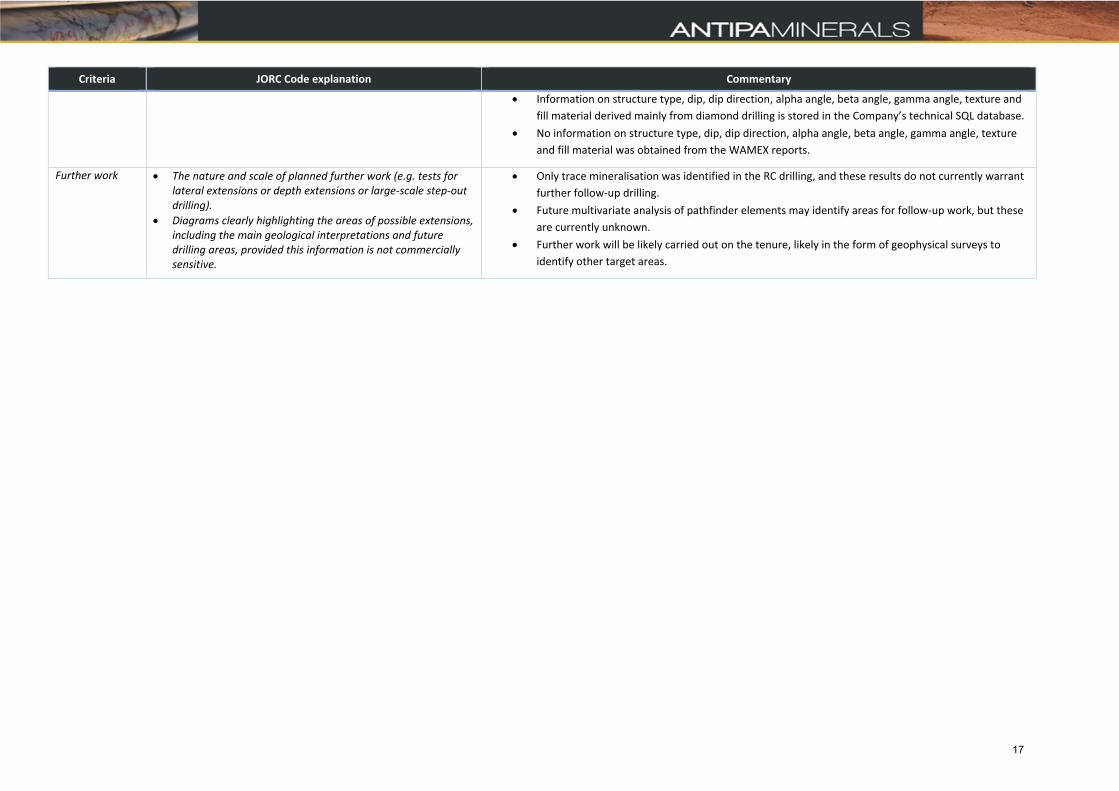
Further work The nature and scale of planned further work (e.g. tests for lateral extensions or depth extensions or large‐scale step‐out drilling).
Diagrams clearly highlighting the areas of possible extensions, including the main geological interpretations and future drilling areas, provided this information is not commercially sensitive.
Only trace mineralisation was identified in the RC drilling, and these results do not currently warrant
further follow‐up drilling.
Future multivariate analysis of pathfinder elements may identify areas for follow‐up work, but these
are currently unknown.
Further work will be likely carried out on the tenure, likely in the form of geophysical surveys to
identify other target areas.
17