risk-based management of groundwater contamination in …
TRANSCRIPT
Risk-Based Management of Groundwater Contamination in MichiganAn Analysis of Part 201 of the Natural Resources and Environmental Protection Act
Prepared For:State of Michigan’s Department of Environment Great Lakes, and EnergyOffice of the Great Lakes
Advised By:Dr. Paul Seelbach and Dr. Allen BurtonUniversity of Michigan School for Environment and Sustainability
Prepared By:Morgan Beeler (MPP/MS ‘20) Iqra Nasir (MPP/MS ‘21) Matt Willig (MS ‘20)University of MichiganSchool for Environment and Sustainability

April 2020
MP 363 / Pg. 1
[This page left intentionally blank]

April 2020
MP 363 / Pg. 2
Table of Contents
Acknowledgements 4
Executive Summary 5
1. Introduction 8
1.1. Background 9
1.2. Literature Review 10
1.3. Institutional Controls 14
2. Analyses & Findings 17
2.1. Statute Analysis: State of Michigan NREPA Part 201 17
2.2. Comparative Analysis: Minnesota, Wisconsin, and Wyoming 28
2.3. Practitioner Perspectives: Qualitative Insights Into the Process of Using Institutional
Controls 38
2.4. Data and Visualizations 48
2.5 Groundwater Models 52
3. Discussion & Recommendations 54
Glossary of Terms 60
Works Cited 63
Appendices 66

April 2020
MP 363 / Pg. 3
[This page left intentionally blank]

April 2020
MP 363 / Pg. 4
Acknowledgements
We would like to express our most sincere gratitude to State of Michigan personnel at EGLE
and DHHS for their efforts and contributions to our project. Their hard work and generosity were
greatly appreciated and helped us develop a successful and enlightening report. Additionally,
we are very grateful for the work of EGLE’s 2019 summer legal interns in helping us gather
statute information on other states’ use of institutional controls.
We also thank the many professors at the University of Michigan who assisted in developing our
interview methodology and our understanding of GIS data and software for analysis.
We extend special thanks to our client – EGLE Office of the Great Lakes’ Emily Finnell,
Christina Pastoria, and James Clift – and our advisors – Dr. Paul Seelbach and Dr. Allen Burton
– for sharing their expertise, contact networks, and thoughtful feedback as they guided our
exploration and analysis of this project.
Finally, we thank the University of Michigan School for Environment and Sustainability and
EGLE for their financial support of this project.
Disclaimer: This paper represents the opinions of the authors and is the product of academic
research to meet Master’s degree requirements for the University of Michigan’s School for
Environment and Sustainability. It is not meant to represent the position or opinions of the
University of Michigan or its members. Any errors are the fault of the authors. Information
provided in the report is not an alternative to legal or policy advice from an appropriately
qualified professional. Specific questions regarding any legal or policy matters should be
directed to an appropriately qualified professional.

April 2020
MP 363 / Pg. 5
Executive Summary
Restrictive management actions are used across the State of Michigan to address groundwater
contamination; however, the long-term impacts of these management choices have not been
fully assessed. The 2016 Michigan Water Strategy recommends developing a comprehensive
groundwater management strategy to better protect Michigan’s valuable water resources, but
the lack of understanding regarding long-term impacts of restrictive management actions poses
a major barrier to developing an effective management strategy.
Building a deeper understanding of the impacts of restrictive management actions was identified
as a priority for cross-agency collaboration by the State of Michigan Interdepartmental Water
Team, comprised of representatives from the Department of Environment, Great Lakes, and
Energy (EGLE), Department of Natural Resources (DNR), Michigan Economic Development
Corporation (MEDC), Department of Agriculture and Rural Development (MDARD), Department
of Health and Human Services (MDHHS), and Department of Transportation (MDOT). An
Interagency Long-Run Risk Working Group comprised of members of the Interdepartmental
Water Team was created to develop a plan to address the issue. Through several months of
meeting, the working group developed a draft plan to evaluate the long-term economic cost of
the risk management strategy by comparing the actual costs incurred at current sites to the
expected cost when the management action was selected.
While the Interagency Long-Run Risk Working Group recognized the importance of evaluating
the long-term economic costs of restrictive management actions, it became clear that the
regulatory framework in place for implementing these actions must be understood. Without a full
understanding of the regulatory framework, it would be difficult to offer recommendations for
policy change if it is later determined that the current risk management approach requires
modification. The Office of the Great Lakes developed an interim project team of three master’s
students from the University of Michigan’s School for Environment and Sustainability to analyze
Part 201 of Michigan’s Natural Resources and Environmental Protection Act (NREPA). Part 201
outlines the process for environmental remediation through use of restrictive management
actions to mitigate risks associated with groundwater contamination. Other statutes, including
NREPA Parts 1111 and 2132, also pertain to groundwater contamination and restrictive
management actions. However, the processes for implementing restrictive management actions
are more clearly defined under these statutes than for Part 201. Therefore, developing a better
understanding of the Part 201 process, including its strengths and weaknesses, is critical to
developing future recommendations and intervention strategies after the full economic analysis
is completed.
The project team conducted an analysis of NREPA Part 201, including amendments to the law
between 1995 and 2015, while investigating other state statutes to identify key similarities or
differences in their management of contaminated aquifers. Further, the project team conducted
1 NREPA Part 111: Hazardous Waste Management 2 NREPA Part 213: Leaking Underground Storage Tank Program

April 2020
MP 363 / Pg. 6
a spatial analysis of current land or resource use restrictions (LRURs, synonymously referred to
as institutional controls) using geographic information systems (GIS) data and tools.
Groundwater modeling protocols for projecting the fate and transport of groundwater
contaminants were also investigated to identify ways to increase data availability and
accessibility across the state. The project team also conducted in-person interviews with EGLE
and DHHS staff to understand how Part 201 is implemented in practice and to identify any
challenges associated with enforcing the statute. The project team then used this research to
develop recommendations for enhancing the effectiveness of inter-agency collaboration to
manage of groundwater contamination.
The project team found that while amendments to Part 201 were initially intended to aid in the
development of brownfield sites and limit urban sprawl, the law has consequently been used to
further restrict groundwater resources even outside of urban centers. The law also makes it
difficult for state agencies to fully track contamination under the present reporting requirements
and the ability for liable parties to self-implement cleanup measures without notifying the state,
unless an institutional control is placed on the property. While institutional controls provide
flexibility to owners and operators, allowing them to maintain operations on contaminated
properties if the risk is managed, no attempt has been made to measure the associated long-
run economic or social costs. Continued restriction of groundwater resources warrants
measuring the long-run costs of maintaining risk management focused cleanup criteria.
Michigan is not unique in their process for risk mitigation; most states follow similar protocols. In
the project team’s comparative analysis of Michigan, Minnesota, Wisconsin, and Wyoming’s
environmental protection statutes, several trends emerged. Most notably, no states require
property owners to disclose contamination if the release quantity is below the reportable
quantity. All states allow use of institutional controls, but the level of state involvement (e.g.,
review and approval) and how institutional controls could be used varied. While these states
allow the use of institution controls, the analysis could not measure whether institutional controls
effectively manage groundwater contamination or what the associated long-run costs are.
Interviews with State of Michigan employees resulted in a deeper understanding and
identification of the value of institutional controls and the range of obstacles to addressing
groundwater contamination. Interviewees, who have worked for years on the issue, offered
recommendations to improve prevention and management of groundwater contamination in the
State of Michigan. Interviewees explained that due to current legal statutes, cleaning to
appropriate land use-based criteria or background is not always a viable option. However,
institutional controls are valuable because they are cost-effective and mitigate public health
risks. There are however, a range of obstacles, such as tracking and monitoring, to effectively
addressing groundwater contamination. For example, many interviewees stated that the current
datasets needed to address contamination are incomplete or out of date. Others stated that
limited funding has hindered comprehensive mapping of Michigan’s groundwater resources and,
by extension, tracking of contamination. Interviewees recommended updating data and sources,
creating a more user-friendly platform that allows for easy navigation of the data, adding

April 2020
MP 363 / Pg. 7
additional layers of data, and providing training materials for use of the Remediation and
Redevelopment Division’s (RRD) Environmental Mapper (see section 2.4).
The project team’s interviews with staff and online research indicate that data available to staff
is disparate across agencies. Most staff use agency or division specific systems for collecting
and coding data. For example, Environmental Mapper uses site IDs while the Drinking Water
and Environmental Health Division’s (DWEHD) WellLogic uses parcel IDs (see section 2.4).
Because sites are identified differently, sites with institutional controls on them could be
overlooked during the well permitting process; therefore, it would be beneficial if Environmental
Mapper included parcel IDs in its site data. Another example is the Water Resource Division’s
(WRD) MiWaters database (see section 2.4). Even after a thorough search of WRD’s website
for coding descriptions, the project team was unable to understand what much of the data were
describing. Further, during the project team’s interviews, some staff stated that MiWaters
contained information on Part 201 sites. Subsequent data queries showed that identifying Part
201 sites was particularly onerous because the documents were housed with the permit
documents and not explicitly identified or searchable. Given the difficulties in navigating the
MiWaters data and challenges expressed to the project team from staff during interviews,
improvements could be made to MiWaters to make it more user friendly. Lastly, some of the
databases are missing critical information including site addresses and well records. This could
make it difficult for staff from other agencies to find information about a specific site. Missing
data can be attributed to the use of paper versus electronic records and that not all district staff
provide the same level of detail when entering records into a database.
Analysis of groundwater modeling protocols revealed three areas of weakness: lack of sufficient
funding to complete priority modeling, lack of authority to enforce modeling standards, and lack
of statewide database to house and access groundwater models and associated data.
Increased rule-making authority would allow the department to require groundwater models
submitted with Remedial Action Plans to adhere to these standards, ultimately aiding the
creation institutional controls that accurately reflect the state of contamination. Securing
additional funding would empower the Department to complete modeling on all sites without a
PRP to ensure that all contamination across the state is monitored and potential contamination
risks are fully understood. To enable accurate forecasting of groundwater quantity and quality
across the state, a statewide data management system should be developed to house
groundwater models and groundwater data to feed those models.
Given these analyses, recommendations were given to promote enhanced data availability and
accessibility as well as enhanced decision-making and resources for management.
Improvements to data continuity and improved processes for record keeping could be
undertaken by state agencies without approval or funding from the Michigan legislature.
However, to institute more strict reporting and management requirements where the
professional judgement of EGLE staff sees fit, Part 201 would need to be amended by the
legislature. Further, additional appropriations are needed from the legislature to ensure
comprehensive mapping of Michigan’s aquifers and increase EGLE’s capacity to address
contamination and reduce risks of human exposure.
April 2020
MP 363 / Pg. 8
1. Introduction
The State of Michigan is fortunate to enjoy abundant, accessible groundwater resources in most
parts of the state. Precipitation and snowmelt infiltrate a porous, glacial landscape dominated by
sand and gravel deposits, filling subsurface aquifers that are readily accessible by digging wells.
These aquifers undergird the state of freshwater resource security that supports the livelihoods
of millions of people across the state. Furthermore, Michigan’s porous landscape enables
connectivity and recharge of streams, rivers, and lakes, further supporting the state’s economy
and quality of life. However, this hydrologic connectivity creates significant challenges in
preventing degradation of Michigan’s freshwater supply. Contaminants discharged into the
subsurface are readily transported as groundwater migrates downslope through the porous
subsurface. These plumes of contaminated water threaten public health, are difficult to contain,
and are costly to remediate.
In Michigan, the present legal framework attempts to minimize remedial obligation, and thus
costs, allowing groundwater contamination to be addressed through restrictive management
practices. These are commonly referred to as land and/or resource use restrictions (LRURs) or
institutional controls, which restrict or ban use of groundwater in zones of contamination to
eliminate potential public exposure to contaminants. This framework facilitates redevelopment of
contaminated properties that cannot feasibly be remediated to background levels or unrestricted
residential criteria. Institutional control use is widespread, yet no clear framework exists to
determine when use is appropriate and the long-term impacts associated with their use have not
been fully assessed. The de facto removal of these aquifers from future use may pose long-term
risks to freshwater resource security and public health as the frequency of this practice
increases. Therefore, to ensure perpetual abundance of usable state groundwater resources, it
is essential to understand how risk-based management actions and institutional controls are
used by the state to protect this critical resource.
The analyses presented in this report achieve three objectives put forward by the project team.
Foremost, the project team sought to understand the legal foundation and process for risk-
based management of contaminated groundwater using Part 201 of the Natural Resources and
Environmental Protection Act (NREPA), including how institutional controls are used and
enforced. A literature review, comparative analysis of environmental protection statutes in 16
states, and interviews with state employees were conducted to map the Part 201 process from
start to finish. Next, the project team inventoried the available resources that support state and
local agencies in managing groundwater and groundwater contamination. Analyses of available
data revealed potential knowledge gaps and identified areas where cross-agency collaboration
may reduce delays in addressing groundwater contamination. The project team then
investigated geographic patterns of contamination across the state using GIS analyses to
identify hotspot areas for contamination and the use of restrictive management actions. Lastly,
the project team integrated the findings into recommendations for enhancing data availability
and accessibility as well as the steps needed to support enhanced decision making at the
agency and division levels.

April 2020
MP 363 / Pg. 9
1.1. Background
The Natural Resources and Environmental Protection Act (NREPA) is the umbrella legislation
for the State of Michigan to ensure responsible use of state resources for the enjoyment of
future generations and details management actions for addressing contamination. In particular,
Part 201, section 21(8) of NREPA allows for the implementation of restrictive management
actions that address groundwater contamination. In many cases, this constitutes a de facto
removal of the aquifer or portion of the aquifer from use for the foreseeable future. Over 2,000
sites in the State of Michigan (some estimates include up to 7,000 sites) apply various types of
restrictive management actions to control groundwater contamination. Despite the widespread
and pervasive nature of restrictive management, long-term implications and effects of these
actions have not been assessed in detail and no clear framework exists for determining
appropriate scenarios to use them. This lack of knowledge is a major barrier to developing a
comprehensive groundwater management strategy, as recommended by the 2016 Michigan
Water Strategy. Building a deeper understanding of the impacts of this policy was identified as a
priority for cross-agency collaboration by the State of Michigan Interdepartmental Water Team,
comprised of representatives from the Department of Environment, Great Lakes, and Energy
(EGLE), Department of Natural Resources (DNR), Michigan Economic Development
Corporation (MEDC), Department of Agriculture and Rural Development (MDARD), Department
of Health and Human Services (MDHHS), and Department of Transportation (MDOT). An
Interagency Long-Run Risk Working Group made up of members of the Interdepartmental
Water Team was created to develop a plan to address the issue.
The working group consists of staff from the EGLE’s Office of the Great Lakes (OGL),
Remediation and Redevelopment Division (RRD), Water Resources Division (WRD), Drinking
Water and Environmental Health Division (DWEHD), and MDHHS:3
Emily Finnell (EGLE-OGL)
Christina Pastoria (EGLE-OGL)
Mitch Adelman (EGLE-RRD)*
Dan Rockafellow (EGLE-RRD)
Patty Brandt (EGLE-RRD)
Dan Gough (EGLE-RRD)
Eric Chatterson (EGLE-WRD)
Matt Gamble (EGLE-DWEHD)
Steve Crider (MDHHS)
Through several months of meeting, the working group developed a draft plan to evaluate the
long-term economic cost of the risk management strategy by comparing the actual costs
incurred at current sites to the expected cost when the management action was selected. The
group developed a draft request for proposals (RFP), which can be referenced in Appendix A.
While the Interagency Long-Run Risk Working Group recognized the importance of evaluating
the long-term economic costs of restrictive management actions, it became clear that the
regulatory framework in place for implementing these actions must be understood. Without a full
understanding of the regulatory framework, it would be difficult to offer recommendations for
policy change if it is later determined that the current risk management approach requires
3 (*) denotes recent retirement

April 2020
MP 363 / Pg. 10
modification. The OGL developed an interim project team of three master’s students from the
University of Michigan’s School for Environment and Sustainability to analyze Part 201 of
NREPA. Part 201 outlines the process for environmental remediation through use of restrictive
management actions to mitigate risks associated with groundwater contamination. Other
statutes, including NREPA Parts 1114 and 2135, also pertain to groundwater contamination and
restrictive management actions. However, the processes for implementing restrictive
management actions are more clearly defined under these statutes than for Part 201. Therefore,
developing a better understanding of the Part 201 process, including its strengths and
weaknesses, is critical to developing future recommendations and intervention strategies after
the full economic analysis is completed.
1.2. Literature Review
To understand the nature of restrictive management and why it emerged as an alternative to
remediation of groundwater to background levels, a literature review was conducted. The review
summarizes the State of Michigan’s groundwater resources, explains how development of
hydrologic sciences influenced legislative actions to protect groundwater (see Figure 1), and
introduces the present legal framework for managing contaminated groundwater.
The State of Michigan relies heavily on groundwater resources to support public and private
sector demands, withdrawing approximately 700 mgd (million gallons of water daily) from
subsurface aquifers.6 Industrial wells withdraw approximately 180 mgd, while agriculture and
aquaculture demands total approximately 169 mgd.7 Providing safe drinking water to Michigan
residents also places significant demand, approximately 188 gallons per capita per day, on
Michigan’s groundwater resources. Approximately 1.25 million private household wells8 serve
approximately 2.6 million citizens while public groundwater supply systems serve approximately
1.7 million citizens.9 These resources are supplied by influxes of precipitation and snowmelt that
infiltrate a porous, sand and gravel-dominated landscape and accumulate in subsurface
aquifers10. Michigan’s present climate regime and porous landscape has allowed the state to
enjoy the security of virtually unlimited freshwater resources, which support the vibrant economy
that millions of people depend on.
Despite this dependence and apparent security, Michigan has struggled to adequately protect
this precious resource from contamination.11 The porous landscape that enables rapid recharge
of aquifers also enables rapid transport of contaminant plumes downslope through the
subsurface, leaving much of the state vulnerable to contamination. Severe groundwater
contamination presently inhibits designated uses at over 3,000 known sites across the state. In
these areas, local or state governments may restrict or ban groundwater use to manage
4 NREPA Part 111: Hazardous Waste Management 5 NREPA Part 213: Leaking Underground Storage Tank Program 6 National Ground Water Association, 601 Dempsey Rd., Westerville, OH 43081-8978. 7 Ibid. 8 Michigan Department of Environment, Great Lakes, and Energy; Drinking Water & Municipal Assistance Division. 9 National Ground Water Association, 601 Dempsey Rd., Westerville, OH 43081-8978. 10 USGS. (2013). Ground Water And Surface Water A Single Resource. doi: https://pubs.usgs.gov/circ/circ1139/ 11 Dempsey, D. (2018) The Sixth Great Lake: The Emergency Threatening Michigan's Overlooked Resource.
F.L.O.W.

April 2020
MP 363 / Pg. 11
ongoing contamination from sources including urban and agricultural runoff, abandoned wells,
chemical contamination, failing septic systems, fracking, leaking underground storage tanks,
and legacy contamination.12 Moreover, predicting the impact of climate change on groundwater
quality remains an ongoing challenge. Increased frequency of precipitation and extreme
weather events may increase mobility of contaminants in the subsurface, reducing available
groundwater supplies across the state13, amplifying the impact of present de facto losses by
restrictive management practices. These challenges necessitate development of an increased
understanding of the long-term risks and costs associated with the current restrictive risk
management approach to groundwater contamination.
Water System Context
Groundwater constitutes an essential component of Michigan’s hydrologic budget. However, the
importance of groundwater has been historically undervalued because it resides in the
subsurface, stored in spaces between soil particles, sediment particles, and rock fractures, and
functionally invisible to the public. Like surface water, groundwater flows generally downslope
with a direction and rate determined by complex interactions between differential pressure,
gravity, surface topography, subsurface geology, well pumping activity, and other variables.14
Michigan’s porous landscape hydrologically links groundwater and surface water into a single
system15. Thus, human activities that discharge pollutants into groundwater are likely to create
mobile contamination plumes; these can migrate several meters to several kilometers and
diffuse into surface waters magnifying the potential for human exposure. Therefore, providing
equal protections for groundwater and surface water is crucial to reducing potential
contamination of public water supplies.
Historic Scientific Understanding of Groundwater Contamination
In Michigan, legal protections for groundwater historically lagged behind surface water
protections. Hydrologic science was comparatively underdeveloped prior to the 1950’s16,
facilitating treatment of the resource as a virtually limitless wastebasket. United States public
health officials first recognized that bacteriological contamination from sewers and drains could
migrate via subsurface water into surrounding public wells and threaten public health in the
1870’s.17 By the early 1900’s, scientific consensus established that groundwater contamination
could migrate through the subsurface into surrounding streams and rivers. During this time,
hydrologic studies determined that groundwater flows through porous substrate, that shallow
groundwater and surface water are hydrologically linked as part of a single system18, and that
12 Ibid. 13 Cherkauer K.A., Sinha T. (2010) Hydrologic impacts of projected future climate change in the Lake Michigan
region. Journal of Great Lakes Research 36:33-50. DOI: 10.1016/j.jglr.2009.11.012. 14 Colten, C. (1991). A Historical Perspective on Industrial Wastes and Groundwater Contamination. Geographical
Review,81(2), 215-228. doi:10.2307/215985 15 Winter, T. C., Harvey, J. W., Franke, O. L., & Alley, W. M. (1998). Ground water and surface water; a single
resource (No. 1139). US Geological Survey. 16 Colten, C. (1991). A Historical Perspective on Industrial Wastes and Groundwater Contamination. Geographical
Review,81(2), 215-228. doi:10.2307/215985 17 Colten, C. “Groundwater Contamination: Reconstructing Historical Knowledge for the Courts.” Applied Geography,
vol. 18, no. 3, Elsevier Ltd, 1998, pp. 259–73, doi:10.1016/S0143-6228(98)00017-4. 18 Winter, T. C., Harvey, J. W., Franke, O. L., & Alley, W. M. (1998). Ground water and surface water; a single
resource (No. 1139). US Geological Survey.

April 2020
MP 363 / Pg. 12
groundwater could leach and mobilize organic and inorganic compounds from surrounding
substrate.19
Soon thereafter, a landmark 1927 study20 used monitoring wells to track bacterial and chemical
constituents in the subsurface, concluding that contamination plumes can be mapped and
monitored as they migrate through the subsurface. In the 1930’s, industrial engineering texts,
geological reports, and government groundwater publications began to incorporate these
findings and advise against dumping pollutants into seepage pits in the vicinity of public water
supplies.21 However, groundwater contamination by industrial pollutants, which do not degrade
as they flow through the subsurface and can travel much further from the source than biological
contaminants, was not scrutinized in Michigan until the 1940s when a chemical factory in
Lansing, MI polluted the municipal water supply. The company dumped trinitrophenol into a pit,
contaminating the local aquifer and associated municipal wells22, ultimately requiring intermittent
pumping until the early 1960s to remediate. Despite the dangers to human health by this
contamination, no policy changes were instituted to regulate industrial groundwater inputs.
By 1960, groundwater scientists were capable of developing models predicting flow paths of
subsurface contamination.23 While advances in groundwater science highlighted the mobility of
industrial contaminants, discharges of untreated waste into seepage pits, lagoons, or deep-well
injections continued24 until regulations in the late 1970’s prohibited the practice.
Legal and Regulatory History of Groundwater Protection (1949-1995)
Before 1949, the lack of statutory groundwater laws allowed widespread dumping of pollution
into Michigan’s groundwater. Polluters could be sued for damages under correlative rights,
which prohibit landowners in Michigan from interacting with groundwater in ways that reduce the
quality or quantity of available groundwater for surrounding landowners25; however, before
groundwater science was sufficiently developed and accepted, plaintiffs in groundwater
contamination court cases (e.g. 1889, Upjohn v. Richland Twp; 1938, Joldersma v. Muskegon
Development Co.) often failed to conclusively prove that the defendant had contaminated the
water supply.
The first major step towards establishing statutory protections for state groundwater resources
came in 1949, after public outcry was sparked by winter pileups of thousands of dead, oil-
covered duck carcasses along the heavily industrialized and polluted Detroit River banks. The
19 Colten, C. (1991). A Historical Perspective on Industrial Wastes and Groundwater Contamination. Geographical
Review,81(2), 215-228. doi:10.2307/215985 20 Stiles, C. W. Experimental bacterial and chemical pollution of wells via groundwater, and the factors involved. No.
147. US Government Printing Office, 1927. 21 Colten, C. “Groundwater Contamination: Reconstructing Historical Knowledge for the Courts.” Applied Geography,
vol. 18, no. 3, Elsevier Ltd, 1998, pp. 259–73, doi:10.1016/S0143-6228(98)00017-4. 22 Deutsch, M,. Ground-Water Contamination and Legal Controls in Michigan. United States Department of the
Interior, Geological Survey, 1963. 23 Colten, C. “Groundwater Contamination: Reconstructing Historical Knowledge for the Courts.” Applied Geography,
vol. 18, no. 3, Elsevier Ltd, 1998, pp. 259–73, doi:10.1016/S0143-6228(98)00017-4. 24 Colten, C. (1991). A Historical Perspective on Industrial Wastes and Groundwater Contamination. Geographical
Review,81(2), 215-228. doi:10.2307/215985 25 Colten, C. “Groundwater Contamination: Reconstructing Historical Knowledge for the Courts.” Applied Geography,
vol. 18, no. 3, Elsevier Ltd, 1998, pp. 259–73, doi:10.1016/S0143-6228(98)00017-4.

April 2020
MP 363 / Pg. 13
state legislature amended Act 245 of 1929 to create the Michigan Water Resources
Commission (WRC), tasked with regulating and restricting pollution of surface and subsurface
waters.26 In 1958, the WRC responded to increasing reports of groundwater contamination
pollution from WWII-era factory sites and former mining areas by attempting to pass regulations
requiring treatment of hazardous waste before discharge into groundwater.27 However, national
attention to groundwater contamination, galvanized by the New York Love Canal contamination
in 1978, ultimately forced federal and state legislatures to properly protect groundwater
resources. Michigan passed solid waste management and hazardous waste management laws
in 1978 and 1979, respectively, and instituted the 1958 regulations proposed by the WRC in
1980.28 Simultaneously, the U.S. Congress passed the 1980 Superfund law to provide funds for
remediation of contaminated sites identified by each state. These laws reduced threats of
groundwater contamination posed by landfills and hazardous materials.
Michigan’s state legislature went further to protect groundwater resources in 1982 by, passing
Michigan Environmental Response Act (MERA), which mirrored the federal Comprehensive
Environmental Response, Compensation, and Liability Act (CERCLA). MERA established strict
liability for contaminated sites and included “polluter-pays” provisions that required cleanup of
contamination to non-detectable, background levels. These provisions held owners and
operators of contaminated sites liable for cleanup costs whether they represented the original
source of contamination or not.6 In 1990, MERA was amended to categorize sites by cleanup
standards. Type A sites were cleaned to background levels, Type B sites were cleaned to risk-
based criteria, and Type C site cleanups eliminated exposure potential through restrictive
management actions but would not necessarily remove contaminants. Today, MERA is known
as the Natural Resource and Environmental Protection Act (NREPA) Part 201.
Current Regulatory Framework (1995-Present)
In 1995, the state legislature shifted to a risk-based management framework that no longer
required cleaning of contaminated sites to background levels. The 1995 overhaul of NREPA
Part 201 raised the burden of proof to hold a potentially responsible party (PRP) liable for the
cost of remediation activities at contaminated sites with a history of multiple owners and limited
evidence to identify which contaminated the site. The present framework manages groundwater
contamination by allowing the option to ban the use of groundwater in zones of contamination to
remove potential pathways for public exposure to contaminants. These relaxed regulations,
which enable expedited redevelopment of contaminated properties29 that cannot feasibly be
cleaned up to background levels, have left thousands of sites without a PRP and with only
public funding for remediation activities. Consequently, the state and private entities have a
short-term financial incentive to pursue restrictive management, rather than remediation, of sites
with contaminated groundwater because of the comparatively low initial cost of implementation.
Moreover, the state is only legally obligated to mitigate, rather than completely eliminate,
unacceptable risks to public health. Restrictive management actions, which constitute a de facto
26 Deutsch, M,. Ground-Water Contamination and Legal Controls in Michigan. United States Department of the
Interior, Geological Survey, 1963. 27 Dempsey, D., (2019). “Michigan Groundwater Policy: A History.” FLOW, 15 Mar. 2019. 28 Ibid. 29 Ibid.
April 2020
MP 363 / Pg. 14
removal of that portion of the aquifer from future use, may carry unexpected long-term public
health and freshwater supply risks as their frequency of use increases. Moreover, long-term
costs of restrictive management practices, which often include structural barriers30 to contain
contaminants, have not been estimated and complications that bear significant additional costs
may occur. As such, it is unclear whether current practices represent a more cost-effective
strategy than remediation.
Restrictive management practices are carried out by placing land and/or resources use
restrictions (LRURs) on contaminated properties. LRURs are more commonly referred to as
institutional controls and restrict site use, modify user behaviors, and alert residents to the
presence of contamination, ultimately keeping residents and the surrounding environment safe
from the release of contaminants. Beyond simply limiting or restricting activities that expose
humans to contamination, institutional controls are intended to facilitate safe reuse of a
contaminated site and reduce development of uncontaminated properties where possible. In
practice, institutional controls may prevent drilling of wells in contaminated aquifers, construction
of residential areas on top of contaminated soils, public access to contaminated areas, and any
practices that expose humans to contamination levels above state or federal standards.
1.3. Institutional Controls
Section 20121 of NREPA authorizes the use of LRURs to restrict contaminated land or resource
uses that may result in public exposure to toxic groundwater contaminants.31 Institutional
controls are legal, non-engineering instruments that place restrictions on the use of sites with
contaminated groundwater and are synonymous with LRURs.32 The legal authority for
institutional controls is derived from statutory laws, English common law, and local land use
controls. These include, but are not limited to, the following:
easements: legal documents granting the holder, not necessarily the property owner,
the right to use (affirmative) or restrain (negative) use an area of land
conservation easements: legal documents filed in the local county deed registry that
grant a governmental entity, charitable or educational association, corporation, trust, or
other legal entity the ability to legally restrict property owners from significantly modifying
the present state of an area of land (e.g., by property redevelopment)
local government controls: a variety of tools used to control land use by local
governments. These include: planning and zoning maps, subdivision plats, building
permits, siting restrictions, groundwater use restrictions via drilling prohibitions or well-
use permits
ordinances: legislation enacted by a municipal authority. Zoning ordinances regulate
permitted land-use practices while subdivision ordinances regulate land-use conversions
restrictive covenant: An enforceable promise between the state and property owners
to refrain from certain land use practices or maintain an exposure barrier (e.g. clay cap,
30 Schnapf, L. P. (2002). How to Use Institutional Controls for Contaminated Sites (pp. 25-37, Rep.). 31 MCL 324.20121 (8) 32 English, M. R., & Inerfeld, R. B. (1999). Institutional controls for contaminated sites: Help or hazard. Risk, 10, 121.

April 2020
MP 363 / Pg. 15
parking lot). Restrictive covenants are executed by documents filed in the local county
deed registry
The primary objectives of using an institutional control are reducing or restricting exposure to
hazardous substances, eliminating potential contamination exposure pathways, assuring the
effectiveness and integrity of containment or exposure barriers, and assuring the effectiveness
and integrity of remediation activities undertaken at a contaminated site.33 Sites with institutional
controls may be redeveloped, provided the property owner adheres to the restrictions placed on
that property. In Michigan, restrictive covenants are the most common form of institutional
control used by the state to close off contaminated sites.34 Restricted properties are
documented by RRD and displayed on Michigan’s public-facing database, Environmental
Mapper.
33MCL 324.20121 (1) 34 Schnapf, L. P. (2002). How to Use Institutional Controls for Contaminated Sites (pp. 25-37, Rep.).

April 2020
MP 363 / Pg. 16

April 2020
MP 363 / Pg. 17
2. Analyses & Findings
To understand the process Michigan uses for detecting and managing contamination, the
project team conducted statute analyses of NREPA Part 201 as well as the states of Minnesota,
Wisconsin, and Wyoming. Further, to develop an understanding of how Part 201 is implemented
in practice and to identify any challenges translating the statute into action, the project team
conducted interviews with 15 employees at the state and local levels in Michigan. Given the
importance of data in tracking contamination, the project team also developed a data source
inventory that documented the data availability from state agencies such as EGLE and MDHHS.
Additionally, the data source inventory included geospatial information, which the project team
used to develop thematic maps to better understand where contamination exists in conjunction
with other factors, such as population centers and wellhead protection areas.
2.1. Statute Analysis: State of Michigan NREPA Part 201
Before Michigan’s Natural Resources and Environmental Protection Act (NREPA) Part 20135
was enacted, it was preceded by the Michigan Environmental Response Act (MERA).36 MERA
was enacted in 1982 as the state-law counterpart to the federal Comprehensive Environmental
Response, Compensation, and Liability Act (CERCLA)37 and ensured state eligibility for funds
from the federal Superfund program. MERA created a list of contaminated sites; however, it did
not include liability provisions. 1990 amendments to MERA imposed liability on owners and
operators, which enabled more rapid response to the releases of hazardous substances into the
environment (e.g. water, soil, air) by extending government rights to issue cleanup orders,
implement cleanups, and recover the cleanup costs from parties assigned strict-status liability.
After the 1990 amendments, Michigan legislators became concerned that strict-status liability
under MERA burdened property transactions, obstructed real estate development, and was
leading to negative environmental impacts through increased urban sprawl. As such, in 1992 a
working group made up of stakeholders from three development and investment interests38,
three local governments39, and 12 members of the legislature40 was created to discuss
recommendations for amendments to MERA. Their charge was as follows:
“... examine the impacts of state environmental laws and policies on urban sprawl,
review current progress in developing approaches for reuse of contaminated urban
properties, and make findings and recommendations to the Special Ad Hoc Committee
on Revitalizing Our Michigan Cities that encourage private reinvestment in our older
35 Michigan Natural Resources and Environmental Protection Act (NREPA), Part 201: Environmental Remediation.
Act 451 of 1994. 36 Michigan Environmental Response Act (MERA). Act 307 of 1982, Repealed. 37 Comprehensive Environmental Response, Compensation, and Liability Act (CERCLA). 42 U.S. Code Chapter 103. 38 Development/Investment: Ted Gatzaros (400 Monroe Associates), Larry Marantette (ANR Development
Corporation), and Ronald Waybrant (Fishbeck, Thompson, Carr, Huber) 39 Local Government: Ron Flies (City of Detroit), George Korthauer (City of Petoskey), and Dewey Henry (Wayne
County) 40 Michigan House Representatives: Tom Alley, J.M. Middaugh, Morris W. Hood Jr., Ken Sikkema, Curtis Hertel, Jan
C. Dolan, James A. Kosteva, Bill Bobier, Kirk A. Profit, and Tom L. Hickner

April 2020
MP 363 / Pg. 18
urban areas without sacrificing environmental protection or public health.”41
The working group met over eight months and developed a series of 10 recommendations for
amendments to MERA that encourage redevelopment of brownfields and reinvestment in
cities.42 In response to recommendations developed by the working group, the legislature
amended MERA in 1995, known today as NREPA Part 201, to include limited liability for
purchasers of contaminated property and their lenders and approval for use of institutional
controls.
Rather than a strict status-liability law43 like MERA and CERCLA, Part 201 focused on causation
liability in conjunction with risk management. The idea was to make it easier for people to own,
re-develop, and transfer contaminated property without the fear of incurring potentially
substantial liability, specifically in the urban industrial core areas. Prior to the MERA
amendments, a new property owner could be held liable for contamination of the property, even
if the contamination originated from activities of a previous owner or migration from another
property. Lending institutions could also be held liable if the current property owner was unable
to remediate the contamination. Similar to Part 201, 2002 amendments to CERCLA44 also
provided for limitations of liability for people purchasing contaminated property – bona fide
prospective purchases (BFPPs).45 The risks on the property must still be managed by either the
purchaser or through an agreement with the EPA, which is consistent with the amendments to
MERA. Therefore, through the BFPP, “the purchaser agrees to provide full cooperation,
assistance, and facility access to the persons that are authorized to conduct response actions at
the facility (including the cooperation and access necessary for the installation, integrity,
operation, and maintenance of any complete or partial response action at the facility), is in
compliance with any land use restrictions established or relied on in connection with the
response action at a facility, and does not impede the effectiveness or integrity of any
institutional control employed at the facility in connection with a response action.”46
The following explains when Part 201 is triggered and how it affects liability, obligation,
response, and enforcement.
41 Michigan House of Representatives, Special Ad Hoc Committee on Revitalizing Our Michigan Cities. Citizen
Advisory Group, Findings and Recommendations State Environmental Policies. January 1993. 42 Ibid. 43 Strict status-liability holds the PRP responsible for contamination regardless of intent or perceived legality. In other
words, the PRP cannot claim it was not negligent or that is was within industry standards to avoid liability. 44 USEPA. “Memorandum: Bona Fide Prospective Purchasers and the New Amendments to CERCLA.” May 31,
2002. 45 USEPA defines bona fide prospective purchaser as “a person, or tenant of that person, who acquires ownership of
a facility after the date of enactment of the Brownfields Amendments, January 11, 2002, and by a preponderance of the evidence that establishes 1) disposal at the facility occurred prior to acquisition, …, 4) the person exercises “appropriate care” and “reasonable steps” to deal with the hazardous substance.”
46 42 USC Ch. 103: COMPREHENSIVE ENVIRONMENTAL RESPONSE, COMPENSATION, AND LIABILITY. Par. (35)(A). Pub. L. 107–118, §223(1)

April 2020
MP 363 / Pg. 19
2.1.1. Triggers
Part 201 is “triggered” – or put into action – when an owner or operator becomes aware of the
facility (i.e., when concentrations of a hazardous substance are greater than the criteria for
unrestricted residential use). Therefore, until soil or groundwater concentrations are found to
exceed a land use criterion, no other obligations are triggered, which is almost always long after
the initial release. It is important to understand the definitions of hazardous substance, release,
and facility.
Part 201 defines “hazardous substance” as “any substance that the department
demonstrates, on a case by case basis, poses an unacceptable risk to the public health,
safety, or welfare, or the environment, considering the fate of the material, dose-
response, toxicity, or adverse impact on natural resources.”47
A list of substances that are considered “hazardous” can be found on the EPA’s
website.48 It is important to note that the substance must be deemed hazardous to be
controlled under CERCLA and NREPA. For the most part, Part 201 refers to CERCLA in
its definition of hazardous substances, however, there are two exceptions: 1) Part 201
defines “hazardous substance” more broadly than CERCLA to include petroleum49, and
2) Part 201 exempts "fruit, vegetable, [and] field crop residuals [and] processing by-
products, [and] aquatic plants, that are applied to the land for agricultural use or for use
as an animal feed, if the use is consistent with generally accepted agricultural
management practices developed pursuant to the Michigan right to farm act" from the
definition.50
Emerging contaminants are not necessarily included in CERCLA’s hazardous
substances, unless they have been given a hazardous designation by the EPA. For
example, although it is widely known that PFAS51 chemicals may have negative health
consequences, they have not been designated as a hazardous substance by the EPA.52
In the current Congress (116th), multiple bills – H.R. 2500, H.R. 535, and S. 638 – have
been introduced to direct the EPA to designate PFAS as hazardous substances under
CERCLA, but none of the bills have been passed to-date. However, Part 201 gives
EGLE-RRD the authority to designate hazardous substances if they pose a risk to public
health or the environment and as such, PFAS has been declared a hazardous
substance. It should be noted that because this a more stringent approach than the
EPA, the state cannot require the EPA to provide federal funds to clean up PFAS
47 MCL 324.20101(1)(x)(i-iv) 48 US EPA. “Consolidated List of Chemicals Subject to EPCRA, CERCLA, and CAA.” June 2019 49 MCL 324.20101(1)(x)(iv) 50 MCL 324.20101(1)(x) 51 According to the Environmental Protection Agency, PFAS represents per- and polyfluoroalkyl substances (including
PFOA and PFOS) which are a group of man-made chemicals manufactured since the 1940s. PFOA and PFOS are very persistent in the environment and in the human body – meaning they don’t break down and they accumulate over time – and there is evidence that exposure to PFAS can lead to adverse human health effects.
52 Congressional Research Service. “Regulating Drinking Water Contaminants: EPA PFAS Actions.” August 6, 2019.

April 2020
MP 363 / Pg. 20
contamination. Much of the pressure from states to the EPA to declare PFAS as
hazardous substances stems from the additional funding and remediation efforts that
would be made available under CERCLA.
Part 201 defines “release” as “any spilling, leaking, pumping, pouring, emitting,
emptying, discharging, injecting, escaping, leaching, dumping, or disposing of a
hazardous substance into the environment, or the abandonment or discarding of barrels,
containers, and other closed receptacles containing a hazardous substance.”53
Part 201 defines “facility” as “any area, place, parcel or parcels of property, or portion of
a parcel of property where a hazardous substance in excess of the concentrations that
satisfy the cleanup criteria for unrestricted residential use has been released, deposited,
disposed of, or otherwise comes to be located.”54
Cleanup criteria are set by EGLE’s Remediation and Redevelopment Division (RRD).
Groundwater cleanup criteria for residential and nonresidential land use can be found in
Table 1 of Michigan’s Administrative Code R 299.455 and were most recently updated in
June 2018.
If response activities are undertaken and the property meets the cleanup criteria for
unrestricted residential use, the property is no longer considered a facility.56 Further, the
property is no longer considered a facility if: 1) the property has been split, subdivided, or
divided from a facility and does not contain hazardous substances in excess of
concentrations that satisfy the cleanup criteria for unrestricted residential use57 or 2)
natural attenuation or other natural processes have reduced concentrations of
hazardous substances to levels at or below the cleanup criteria for unrestricted
residential use.58 To put it simply, for a property to not be considered a facility,
hazardous substances cannot be in excess of the cleanup criteria if the intended use of
the property is unrestricted residential use. If hazardous substances are in excess of
cleanup criteria and an institutional control is put in place, the property is considered a
facility in perpetuity.
2.1.2. Liability
Potentially Responsible Persons (PRPs) are liable when there is knowledge of the facility and
have joint and several liability59 for all response activity costs incurred by the state relating to
implementation of the response activity. PRPs can be made to provide "the full value of injury to,
53 MCL 324.20101(1)(pp)(i-vii) 54 MCL 324.20101(1)(s)(i-vi) 55 Part 201 Generic Cleanup Criteria and Screening Levels. Table 1. Groundwater: Residential and Nonresidential. 56 MCL 324.20101(1)(s)(i) 57 MCL 324.20101(1)(s)(v) 58 MCL 324.20101(1)(s)(vi) 59 The Legal Information Institute defines joint and several liability as “two or more parties that are independently
liable for the full extent of the injuries.”

April 2020
MP 363 / Pg. 21
destruction of, or loss of natural resources, including the reasonable costs of addressing the
injury, destruction, or loss resulting from [a] release.”60
The following people are liable under Section 26 of Part 201:61
• The owner or operator of a facility if the owner or operator is responsible for an activity
causing a release or threat of release.
• The owner or operator of a facility at the time of disposal of a hazardous substance if the
owner or operator is responsible for an activity causing a release or threat of release.
• An owner or operator of a facility who becomes an owner or operator on or after June 5,
1995.
• A person who by contract, agreement, or otherwise arranged for disposal or treatment,
or arranged with a transporter for transport for disposal or treatment, of a hazardous
substance owned or possessed by the person, by any other person, at a facility owned
or operated by another person and containing the hazardous substance.
• A person who accepts or accepted any hazardous substance for transport to a facility
selected by that person.
• The estate or trust of a person described above.
Part 201 defines “owner” as “a person who owns a facility”62 and defines “operator” as “a person
who is in control of or responsible for the operation of a facility.”63
As with most laws, there are exemptions to Part 201’s liability standards. Exemptions include: 1)
owners and operators who conduct a baseline environmental assessment (BEA), 2) owners and
lessees of severed subsurface mineral rights, 3) owners and occupants of residential real
property,64 3) persons who did not know and had no reason to know that the property was a
facility (e.g. lessees of retail, office, and commercial space), 4) occupiers and operators of
property for the purpose of siting, constructing, operating, or removing a wind energy conversion
system or related components, and 5) owners and operators of property onto which
contamination has migrated.65
Lastly, it is important to address the various defenses to Part 201 liability. For example, an
owner or operator of a facility is not liable if the release was caused by "an act or omission of a
third party other than an employee or agent of the person or a person in a contractual
relationship existing either directly or indirectly with a person who is liable."66 The last two
liability defenses include acts of God and acts of war. Part 201 defines “acts of God” as “an
unanticipated grave natural disaster or other natural phenomenon of an exceptional, inevitable,
60 MCL 324.20126a(1)(a-c) 61 MCL 324.20126(1)(a-e) 62 MCL 324.20101(1)(kk)(i-iii) 63 MCL 324.20101(1)(jj)(i-ii) 64 Law Insider defines residential real property as “property, including vacant land, occupied by, or intended to be
occupied by, in the aggregate, one to four families as their residence.” 65 MCL 324.20126(3)(a-l) 66 MCL 324.20126(4)(d)(iii)

April 2020
MP 363 / Pg. 22
and irresistible character, the effects of which could not have been prevented or avoided by the
exercise of due care or foresight,"67 however, does not define “acts of war.”
2.1.3. Obligations
Part 201 states that liable owners and operators are obligated to disclose contamination to the
state within 24 hours after obtaining knowledge of the release if “the release is of a reportable
quantity of a hazardous substance” under CERCLA (reportable quantities are published in the
Code of Federal Regulations).68 It should be noted that Part 201 does not adopt CERCLA’s
petroleum exclusion as Part 213 has its own process for disclosure of petroleum constituents69
for owners of underground storage tanks. Further, liable owners and operators are required to
notify the state within 30 days if they have reason to believe a concentration of hazardous
substance exceeding the criterion for unrestricted residential use has migrated off their property.
In addition to the reporting requirements above, Section 14 of Part 201 imposes the following
obligations on liable owners and operators:70
• Immediately stop or prevent an ongoing release at the source.
• Immediately implement measures to address, remove, or contain hazardous substances
that are released after June 5, 1995 if those measures are technically practical, are cost
effective, and abate an unacceptable risk to the public health, safety, or welfare or the
environment. At a facility where hazardous substances are released after June 5, 1995,
and those hazardous substances have not affected groundwater but are likely to,
groundwater contamination shall be prevented if it can be prevented by measures that
are technically practical, cost effective, and abate an unacceptable risk to the public
health, safety, or welfare or the environment.
• Immediately identify and eliminate any threat of fire or explosion or any direct contact
hazards.
• Initiate a remedial action that is necessary and feasible to address unacceptable risks
associated with residual NAPL saturation, migrating NAPL, and mobile NAPL using best
practices for managing NAPL, including, but not limited to, best practices developed by
the American society for testing and materials or the interstate technology and regulatory
council.
• Diligently pursue response activities necessary to achieve the cleanup criteria
established under this part. Except as otherwise provided in this part, in pursuing
response activities under this subdivision, the owner or operator may do either of the
following: conduct self-implemented response activities or obtain departmental approval.
Because Part 201 aims to eliminate unacceptable risks to public health, safety, or welfare – not
eliminate contamination completely – the law requires all owners and operators to manage
67 MCL 324.20101(1)(a) 68 MCL 324.20114(1)(b)(i) 69 Petroleum constituents are defined as component substances such as benzene, toluene, and xylenes, plus any additives (e.g., MTBE, lead). 70 MCL 324.20114(1)(c-g)

April 2020
MP 363 / Pg. 23
exposure to hazardous substances at the facility. Therefore, even if a party is not found liable,
they are still responsible for undertaking due care obligations.71
Due care obligations are actions that are necessary to protect against human exposure to
contamination in soil, groundwater, and subsurface vapor. Actions must be taken to ensure safe
use of property that is contaminated and that affected parties are properly notified if there is a
likelihood of exposure (e.g. contamination migration onto another an adjacent property). Due
care obligations include:72
● Prevent anyone using the property from unacceptable exposures to the existing
contamination.
● Prevent anyone from taking actions that cause exacerbation of the existing
contamination, such as migration from your property.
● Take reasonable precautions against the foreseeable acts of third parties, such as
contractors, utility workers, etc.
● Cooperate with and provide access to the person responsible for cleaning up the
existing contamination and don't interfere with their actions.
● Be aware of and comply with any land or resource use restrictions placed on the
property due to the existing contamination. An example might be to prevent the
installation of a drinking water well into contaminated groundwater.
To ensure due care obligations are met, completion of a Baseline Environmental Assessment
(BEA) is recommended during, or immediately following, a property transaction. BEAs allow
property owners liability exemptions; however, they must be conducted within 45 calendar days
of the property purchase date and submitted to EGLE within six months.73 Before the 2010
amendments to Part 201, BEAs were defined as "an evaluation of environmental conditions
which exist at a facility at the time of purchase, occupancy, or foreclosure that reasonably
defines the existing conditions and circumstance[s] at the facility so that, in the event of a
subsequent release, there is a means of distinguishing the new release from existing
contamination."
Since the 2010 amendments, Part 201 defines BEA as "a written document that describes the
results of an all appropriate inquiry and the sampling and analysis that confirm that the property
is a facility."74 There is some ambiguity in the definition of "all appropriate inquiry." Part 201
relies on Part 312 of the Code of Federal Regulations – Innocent Land Owners, Standards for
Conducting All Appropriate Inquiries to define what is appropriate.75 The federal standard refers
to “all appropriate inquiry” as "an evaluation of environmental conditions at a property at the time
of purchase, occupancy, or foreclosure that reasonably defines the existing conditions and
circumstances at the property in conformance with 40 CFR 312."76
71 MCL 324.20107a(1) 72 Department of Environment, Great Lakes, and Energy. “What is Due Care and what are Your Obligations?” 73 MCL 324.20101(1)(f) 74 MCL 324.20101(1)(f) 75 MCL 324.20101(1)(c) 76 Code of Federal Regulations: 40 CFR 312

April 2020
MP 363 / Pg. 24
Although BEAs were originally included in the statute to establish an environmental “baseline,”
the law as it currently stands no longer requires a property owner to differentiate existing
contamination from new. No longer requiring potential purchasers to establish this differentiation
saves time and money; however, it could pose potential long-term risk to purchasers. For
example, if the contamination worsens over time or if they cannot prove they did not cause
contamination due to a lack of understanding of the environmental baseline, innocent property
owners could be found liable with little liability defense to protect them if the contamination
migrates off-site or if they try to sell the property. Additionally, emerging contaminants, or
contaminants that are not currently a concern but may be found to pose risks later, are more
likely to go unreported in the absence of a BEA. PFAS is an example of an emerging
contaminant that has existed for many years but has recently been found to pose risk to human
health. Without detailed BEAs, it is likely PFAS contamination exists in places that are currently
unknown to property owners and the state. The project team found no existing assessment of
whether this change has impacted the effectiveness of the program; however, future studies
may provide greater insight.
In some cases, EGLE may find contamination on a site where the liable party is unknown or no
longer exists, and subsequent owners have exemption from liability. These sites are referred to
as “orphan sites” and become the tax-payers burden. Based on 2018 estimates, there are
around 3,000 orphan sites in Michigan.77 Funding allocation for the cleanup of orphan sites is
not explicitly stated in the statute; therefore, the department with regulatory purview determines
where funds will come from for cleanup, and in some cases may need to appeal to the Michigan
legislature to fund cleanup of priority orphan sites. Generally, the department with regulatory
purview prioritizes orphan sites based on the level of risk they pose to human health, safety,
welfare, and the environment, determining what subsequent actions to take based on cost-
benefit analyses. When the state takes remedial action on a site, they incur the costs. Site
remediation has often been paid for through the Clean Michigan Initiative since 1998; however,
most of those funds have been expended. In rare circumstances, the state may be able to use
cost recovery if they can prove who the original liable party was; however, the liable party must
still be in business or living.
2.1.4. Response
Part 20178, coupled with EGLE administrative rules79, is used to determine how to implement
response activities in order to achieve applicable cleanup criteria. EGLE’s RRD is charged with
establishing cleanup criteria based on the category of land use: residential or nonresidential.
Liable owners and operators are not required to disclose contamination on their property to
EGLE if the release is under the reportable quantity. However, liable owners and operators who
have knowledge a property is a facility are required to notify EGLE and affected property owners
if they have reason to believe that contamination has migrated beyond their property
boundary.80
77 Malewitz, Jim. (2018) “Michigan has 7,300 toxic sites. Money for cleanups is almost gone.” Bridge Magazine. 78 MCL 324.20120a 79 EGLE, Remediation and Redevelopment Division, Administrative Rules 80 MCL 324.20114(1)(b)(ii)

April 2020
MP 363 / Pg. 25
In addition to Section 14 and due care obligations, liable owners and operators of a facility are
generally required to perform the following response activities:81
● Undertake measures as are necessary to prevent exacerbation;
● Exercise due care by undertaking response activity necessary to mitigate unacceptable
exposure to hazardous substances, mitigate fire and explosion hazards due to
hazardous substances, and allow for the intended use of the facility in a manner that
protects the public health and safety;
● Take reasonable precautions against the reasonably foreseeable acts or omissions of a
third party and the consequences that foreseeably could result from those acts or
omissions;
● Provide reasonable cooperation, assistance, and access to the persons that are
authorized to conduct response activities at the facility, including the cooperation and
access necessary for the installation, integrity, operation, and maintenance of any
complete or partial response activity at the facility. Nothing in this subdivision shall be
interpreted to provide any right of access not expressly authorized by law, including
access authorized pursuant to a warrant or a court order, or to preclude access allowed
pursuant to a voluntary agreement;
● Comply with any land use or resource use restrictions established or relied on in
connection with the response activities at the facility; and,
● Not impede the effectiveness or integrity of any land use or resource use restrictions
employed at the facility in connection with response activities.
Liable owners and operators are required to initiate response activities even if they are not
required to disclose their activities to the EGLE.82 Often times, liable owners and operators
choose to self-implement response activities rather than secure prior approval from EGLE.
Because of this, many refer to Part 201 as a self-implementation statute.83 Section 14 of Part
201 does give EGLE-RRD the authority to request the liable owner or operator to provide a
response activity plan, submit a no further action report, and pursue additional response
activities to protect public health, safety, welfare, and the environment, regardless of self-
implementation.84 When the response activity is done under an administrative order, agreement,
or judicial ruling, prior department approval and submission of a response activity plan is
required by the liable party.85 After a party completes response activities that satisfy Part 201
cleanup criteria, whether self-implemented or ordered, they may submit a no further action
report to EGLE documenting their response activities and proving the hazardous substances fall
within the acceptable threshold for land use.86 It is unclear from the statute if EGLE is required
to verify cleanup standards for voluntary actions; however, they do verify cleanup standards for
ordered remediation.
81 MCL 324.20107a(1)(a-f) 82 MCL 324.20114(1)(g) 83 MCL 324.20114(2) 84 MCL 324.20114(1)(h)(i-vi) 85 MCL 324.20114(2) 86 MCL 324.20114(2)

April 2020
MP 363 / Pg. 26
No further action reports must clearly document the response activities undertaken at the facility
and include a signed affidavit from the owner/operator and environmental consultant confirming
the accuracy of the information provided in the report.87 If the response activities satisfy EGLE’s
cleanup criteria for unrestricted residential use, the owner/operator is not required to provide a
postclosure plan or develop a postclosure agreement with the state.88
If a no further action report has been submitted to EGLE that requires land use or resource use
restrictions, a postclosure plan is required.89 A postclosure plan describes the land use or
resource restriction at a facility upon completion of response activities. Part 201 requires that all
postclosure plans include the land use or resource use restriction(s) relied upon (e.g. restrictive
covenant, exposure barrier), as granted by Section 20121.90 Additionally, the postclosure plan
must describe the permanent markers used to indicate the restricted areas.91 Permanent
markers are not required when groundwater is being restricted or if exposure controls (e.g. clay
cap) have been used to reduce the risk of exposure.92
A postclosure agreement is developed between EGLE and the liable owner or operator when
monitoring is required at the facility after the remedial actions are completed. The agreement
must include the liable owner or operator’s plans for monitoring, operating, and maintaining the
effectiveness of the remedial actions in addition to financial assurance to pay for those plans,
unless the financial assurance is found to be an insignificant amount.93 While monitoring of
groundwater is not always required, monitoring provides benefits to assuring long-term
compliance with the institutional control.
2.1.5. Compliance and Enforcement
Part 201 grants EGLE the authority to undertake response activities at facilities as well as
recover costs of cleanup from liable parties, which can incentivize liable parties to comply. The
authorities granted come in a few different forms, including: information requests, access to
facilities, state-initiated response activities, civil or criminal actions, and administrative orders.
Although liable owners and operators are not required in all cases to disclose contamination to
the state, the state may request specific information about the site and activities at the site if
they have reason to believe that contamination may exist.94 Additionally, Part 201 grants EGLE
the authority to access and investigate a property if they have a reasonable belief that the site is
a facility.95 If an owner/operator refuses to comply with the information request or allow EGLE
access to the facility, the attorney general, on behalf of EGLE, can obtain a warrant from the
87 MCL 324.20114d(1, 5) 88 MCL 324.20114d(3)(a) 89 MCL 324.20114d(3)(b) 90 MCL 324.20114c(2)(a) 91 MCL 324.20114c(2)(b) 92 MCL 324.20114c(2)(b)(i-iv) 93 MCL 324.20114d(3-4) 94 MCL 324.20117(1) 95 MCL 324.20117(3)

April 2020
MP 363 / Pg. 27
local jurisdiction or file a civil suit.96 It should be noted that “reason to believe” is not defined in
the statute and would therefore be up to the discretion of state employees.
If EGLE finds contamination at the site that may be an endangerment to public health or the
environment, classifying it as a facility, the owner/operator may be liable for response activities
to clean up the contamination in accordance with Section 27 of Part 201 (see 2.1.2. above).97
EGLE has a compliance and enforcement policy the begins with compliance assistance and
eventually escalates enforcement actions. If the liable party refuses to comply with the required
response activities the state may initiate response activities, issue an administrative order98, and
file a civil action against the liable party seeking relief and recovery of costs and damages.99
The civil fine for liable owner and operators refusing to comply with required response activities
can be up to $25,000.00 per day depending on the severity of the contamination and risks to
public health and the environment.100
While civil actions are most often sought, in some cases criminal actions may be pursued. A
liable owner or operator may be found guilty of a felony if: 1) they knowingly released
contamination that could cause personal injury or property damage; 2) they intentionally made
false statements or representations in state applications, records, reports, or other documents;
3) they intentionally provide inaccurate readings of monitoring devices or inaccurately record
information required by Part 201; or 4) they misrepresent their held qualifications.101 If a person
is found guilty of a felony, they can face fines anywhere from $2,500.00 to $25,000.00 for each
day the release occurred.102 In circumstances where this is the liable parties’ second offense,
they can face fines up to $50,000.00 for each day the release occurred.103
96 MCL 324.20117(7)(a-b) 97 MCL 324.20126a(6) 98 MCL 324.20119(1-2) 99 MCL 324.20126a(7) 100 MCL 324.20126a(4)(a-b) 101 MCL 324.20139(2)(a-d) 102 MCL 324.20139(2) 103 MCL 324.20139(3)

April 2020
MP 363 / Pg. 28
2.2. Comparative Analysis: Minnesota, Wisconsin, and Wyoming
To better understand the State of Michigan’s laws regarding groundwater contamination and the
use of institutional controls, the project team looked at other states in the Great Lakes Basin and
across the United States. The findings can be used to 1) to better understand how other states
manage groundwater resources, and 2) find similarities and differences in the State of
Michigan’s management of groundwater contamination. While practices from other states could
be applied to Michigan’s process for dealing with groundwater contamination, the state would
need to negotiate with the legislature to amend NREPA Part 201 or grant EGLE rulemaking
authority to make any substantial changes.
CERCLA is a federal umbrella policy and after it was enacted, nearly every state wrote a similar
state statute aimed at dealing with contamination of natural resources. States were encouraged
to do this not only to have the ability to hold PRPs liable for cleanup, but also so they could
access Federal Superfund funds for remediation of specific sites within the state. In accordance
with US Federal Law, all states must comply with CERCLA requirements for Federal properties;
however, states are empowered to implement their own CERCLA-like laws that apply to all
properties within their borders. As long as state law is not more stringent for Federal facilities
than private facilities, Federal properties can be held to the state standards.
To understand the broader context of state remediation laws, the project team considered Great
Lakes Basin states as well as a geographic range of other states. In total, the project team
looked at fifteen states: California, Florida, Illinois, Indiana, Minnesota, Missouri, Montana, New
Jersey, New York, Ohio, Pennsylvania, Texas, Washington, Wisconsin, and Wyoming. States
were selected based on geography, groundwater use, and recommendations from EGLE staff.
The project team looked at six major tenets of each state’s law: 1) Whether the state had a
specific process for dealing with groundwater contamination; 2) whether property owners were
required to disclose groundwater contamination and if so, to whom; 3) if an initial assessment of
cleanup costs was required; 4) whether the state gave preference to partial/full remediation, if
deemed feasible; 5) if monitoring (long- or short-term) of the contaminated site was required;
and 6) whether the state allowed for or required the use of institutional controls. The research
concluded that 13 out of 16 states had a specific process for dealing with groundwater
contamination, while the other three states’ statutes had more broad environmental
contamination language. Further, only seven states had explicit requirements for reporting
groundwater contamination to the state, while two states (Michigan and Wisconsin) had
reporting requirements in specific circumstances and six state statutes did not have clear
language on reporting requirements. Montana and Missouri were the only two states that did not
have explicit monitoring requirements for contaminated sites after remedial actions had been
taken, while the other 14 states either required monitoring in all or some cases. Lastly, nearly
every state allowed for the use of institutional controls, with the exception of Ohio. A complete
summarized comparison can be found in Table 1.

April 2020
MP 363 / Pg. 29
Due to time and resource constraints, it was not feasible to complete a full comparative analysis
of all fifteen states against the State of Michigan; therefore, after taking a broad look at each
state’s statute, the project team used USGS data on groundwater use by sector to determine
which states’ water use profiles and population served by groundwater were comparable to
Michigan (see Table 2). From this information, the project team determined that Minnesota,
Wisconsin, and Wyoming had similar water use profiles and percentage of their population

April 2020
MP 363 / Pg. 30
served by groundwater to constitute a reasonable comparison. Minnesota, Wisconsin, and
Wyoming statutes were compared to Michigan, each state analysis concludes with a brief
summary comparison table.
2.2.1. Minnesota
Minnesota is a Great Lakes State, with its northeast corner residing within the Basin and
containing some of Lake Superior’s coastline. The state has a surface area of nearly 80,000
square miles and a population of 5.6 million.104 According to USGS data collected in 2015105,
approximately 55% of Minnesota’s population is served through municipal or private wells.106
The following discussion explains Minnesota’s process for addressing groundwater
contamination, requirements for disclosing contamination, requirements for cleanup cost
assessment and remediation, requirements for monitoring, and permitted uses of institutional
controls as compared to NREPA Part 201. Table 3 then provides a summary of the key
similarities and differences between Minnesota and Michigan.
Process for Addressing Groundwater Contamination
Chapter 15B of the Minnesota Environmental Response and Liability Act (MERLA) has
provisions for the Minnesota Pollution Control Agency (MPCA) to instigate remedial actions to
combat any contaminant release which presents a danger to health, welfare or the
104 U.S. Census Bureau QuickFacts: Minnesota 105 USGS groundwater and surface water use data is collected every five years; therefore, 2015 is the most up-to-
date data available. 106 USGS. “Water Use Data for the Nation” Updated: 2015

April 2020
MP 363 / Pg. 31
environment.107 While this provision would seemingly include groundwater contamination, it is
not as explicitly stated in MERLA as it is in NREPA Part 201. Exclusion of specific groundwater
language could be a benefit, as the statute can be more widely applied to contamination of
various mediums; however, it could also serve as a loophole for PRPs. Section 115B.171 of
MERLA addresses private well testing, but the section is brief and only applies to wells in
Minnesota’s East Metropolitan Area.108 Specifically, section 171 requires the MPCA to maintain
a webpage about poly-fluorinated chemicals (PFC) in the East Metropolitan Area and detail the
process for private and public well PFC sampling. In addition to these requirements, the MPCA
provides an online interactive map system (MN Wells). This is similar to the State of Michigan’s
Environmental Mapper and WellLogic (see section 2.4); however, housed in a single website.
Requirements for Disclosing Contamination
Before the transfer of any property, the owner must disclose any site contamination if the owner
knew, or should have known, the property was subject to contamination by the release of a
hazardous substance. To do this, the owner is required to provide the county recorder with an
affidavit containing a legal description of the property that discloses to any potential transferee:
(1) that the land has been used to dispose of hazardous waste or that the land is contaminated
by a release of a hazardous substance; and (2) the identity, quantity, location, condition and
circumstances of the disposal or contamination to the full extent known or reasonably
ascertainable.109 The county recorder is then required to record the affidavit whereas if a
potential purchaser ran a title search it would be disclosed. If the owner fails to file an affidavit
before the transfer of property, they can be fined up to $100,000.00.110
There is no requirement that the owner notify the state (e.g. MPCA) of contamination, in other
words they may self-implement and remediate the contamination without approval from the
state. As is the case with Part 201, if MPCA requests information from a property owner
regarding a potential release, the property owner is required to provide necessary information
related to the release or potential release.111
Requirements for Cleanup Cost Assessment and Remediation
There was no explicit requirement that the PRP or MPCA do an assessment of cleanup costs,
but portions of the statute allude to the MPCA conducting a cost determination in some
circumstances. For example, MPCA is empowered to relocate residents, businesses, and
community facilities if it determines that relocation is the most “cost-effective” solution over
methods such as transportation, storage, or treatment.112 MERLA also alludes to the
determination of costs in section 115B.20, which explains the ways in which MPCA can use the
remediation fund; however, “… before implementing a project to rehabilitate; the commissioner
107 MSA 115B 108 The East Metropolitan Area refers to the cities of Afton, Cottage Grove, Lake Elmo, Maplewood, Newport,
Oakdale, St. Paul Park, and Woodbury; the townships of Denmark, Grey Cloud Island, and West Lakeland have a potential for significant groundwater pollution from PFCs.
109 MSA 115B.16(2-3) 110 MSA 115B.16(4) 111 MSA 115B.17(3) 112 MSA 115B.17(1)

April 2020
MP 363 / Pg. 32
of natural resources shall provide written notice of the proposed project to the chairs of the
senate and house representatives committees with jurisdiction over environment and natural
resources.”113 It is likely that MPCA conducts an assessment of the cleanup costs in order to
provide the legislature with a full picture of the proposed plan and how funds will be used.
Similar to NREPA Part 201, MERLA requires that cleanup standards be based on the planned
use of the property where the contamination occurred (e.g. residential, industrial).114 However, it
does not give preference for full or partial remediation. If the property belongs to the state and is
using state appropriated funds for response activities, they must provide public notice of the
proposed response actions and open a public comment period.115 In theory the public could
provide comments urging for partial or full remediation, but as stated above, in order to use the
remediation fund written notice of the response activities must also be given to the Senate and
House.
Requirements for Monitoring
Monitoring is not required by MERLA, but instead left to the discretion of the MPCA. The MPCA
may require “monitoring and maintenance” of a contaminated site if it chooses to do so.116
Permitted Use of Institutional Controls
MERLA does allow for the use of institutional controls. Institutional controls include restrictions,
conditions, or controls enforceable by contract, easement, restrictive covenant, statute,
ordinance, or rule, including official controls such as zoning, building codes, and official maps.117
The affidavit required under section 115B.16(2), or a similar notice of a release recorded with
property records, is also considered an institutional control although it does not technically place
any restrictions on the property. Further, the statute does not outline criteria for the use of
institutional controls; rather, similar to monitoring, it is left to the discretion of the MPCA to
determine the criteria for use. Currently, the State of Minnesota has 1,631 institutional controls
in place across the state.118
113 MSA 115B.20(4) 114 MSA 115B.17(2a) 115 MSA 115B.17(2b) 116 MSA 115B.17(16.3b) 117 MSA 115B.02(9a) 118 MPCA Institutional Controls
April 2020
MP 363 / Pg. 33
2.2.2. Wisconsin
Wisconsin is a Great Lakes State, with its eastern edge bordering Lake Michigan and its
northern edge butting up to Lake Superior. The state has a surface area of nearly 54,000
square miles and has a population of 5.8 million.119 According to USGS data collected in 2015,
approximately 40% of Wisconsin’s population is served through municipal or private wells.120
The following discussion explains Wisconsin’s process for addressing groundwater
contamination, requirements for disclosing contamination, requirements for cleanup cost
assessment and remediation, requirements for monitoring, and permitted uses of institutional
controls as compared to NREPA Part 201. Table 4 then provides a summary of the key
similarities and differences between Wisconsin and Michigan.
Process for Addressing Groundwater Contamination
The State of Wisconsin has two primary statutes that address groundwater contamination
response: Groundwater Protection Standards (Wis. Stats 160) and Remedial Action (Wis. Stats
292). The Groundwater Protection Standards were put in place to empower the WiDNR to
develop and enforce standards for minimizing groundwater pollution.121 Remedial Action is
broader, requiring any person who causes the discharge of a hazardous substance to take the
actions necessary to restore the environment to the “extent practicable” and minimize negative
air, land or water impacts.122 Both statutes empower the WiDNR to hold property owners liable
for contamination and provides them latitude in determining the best regulation, as the statute
sets standards but not a specific process. Under the Groundwater Protection Standards,
WiDNR is empowered to establish any type of regulation, including preventative action limits, so
long as they ensure regulated facilities and activities will not cause the concentration of a
substance in groundwater to exceed enforcement standards.123
Requirements for Disclosing Contamination
The Groundwater Protection Standard establishes requirements for groundwater monitoring,
threshold limits, and WiDNR response to threshold violations.124 However, it does not explicitly
state that property owners are to disclose groundwater contamination. Conversely, the
Remedial Action statute is very explicit about notifications hazardous discharges and requires
the WiDNR be notified “immediately of any discharge not exempted.”125 Lastly, WiDNR is
required to maintain a public database of contaminant discharges and update it regularly.126
Requirements for Cleanup Cost Assessment and Remediation
Assessment of cleanup costs is only required when using money from the state environmental
fund. If WiDNR decides to use the state fund, they must perform a cost assessment.127
119 U.S. Census Bureau QuickFacts: Wisconsin 120 USGS. “Water Use Data for the Nation” Updated: 2015 121 Wis. Stats 160.001 122 Wis. Stats 292.11(3) 123 Wis. Stats 160.001(4) 124 Wis. Stats 160.21(1-2) 125 Wis. Stats 292.11(2) 126 Wis. Stats 292.31(1) 127 Wis. Stats 292.25(d)

April 2020
MP 363 / Pg. 34
The Groundwater Protection Standards provides a flexible approach to remediation by
considering local circumstances, conditions, effect on the public and natural resources, health
risks, and history of the site. Chapters 160.23 and 160.25 affirm that the department should to
the greatest extent “feasible”, seek to remedy environmental damage; however, they also
emphasize the importance of remediating where “technically and economically feasible.”128
Unique to Wisconsin statute, WiDNR may “establish by rule additional points of standards
application which the regulatory agency determines are necessary to protect future groundwater
uses and the public interest in the waters of the state.”129
Requirements for Monitoring
Specifically for groundwater, the WiDNR is required to set up a monitoring system using the
best available technology and methodology to determine whether preventive action limits and
enforcement standards have been violated.130 The required monitoring is extensive and must
include criteria to identify hazardous substances, problem assessment monitoring, regulatory
monitoring, at-risk monitoring, management practice monitoring, and an overarching umbrella
monitoring system that contains the aforementioned monitoring. Additionally, it is the
responsibility of the WiDNR to contact other state agencies needed for coordination and
exchange of technical information. Lastly, through the Remedial Action statute, facilities must
undergo “long-term care,” which requires monitoring during operations and after closing.131
Permitted Use of Institutional Controls
Wisconsin allows some residual contamination to remain after a cleanup of contaminated soil or
groundwater. While the Groundwater Protection Standards do not discuss the use of
institutional controls, the Remedial Action statute allows for the use of “continuing
obligations.”132 Continuing obligations are legal requirements and apply to a property even after
the ownership changes. Individuals purchasing a property with a continuing obligation accept
responsibility for maintenance (e.g. maintaining engineering controls). The Remedial Action
statute requires that the WiDNR provide notice to the public by adding the property and
continuing obligation documents to the Wisconsin Remediation and Redevelopment Database
(WRRD). Currently, the State of Wisconsin has 10,499 sites with continuing obligations.133
128 Wis. Stats 160.23(1) 129 Wis. Stats 160.21(2b) 130 Wis. Stats 160.27 131 Wis. Stats 292.01(10) 132 Wis. Stats 292.12(2) 133 WiDNR Open Data. “Continuing Obligations Apply.”

April 2020
MP 363 / Pg. 35
2.2.3. Wyoming
Wyoming is a western state covered by seven river basins: Bear, Green, Northeast WY, Platte,
Powder/Tongue, Snake/Salt, and Wind/Bighorn.134 The state has a surface area of nearly
97,000 square miles and a population of 580,000.135 According to USGS data collected in
2015136, approximately 41% of Wyoming’s population is served through municipal or private
wells.137 While Wyoming’s population is quite small compared to Michigan, their daily
groundwater withdrawals are very similar - 748.5 mgal/day and 767 mgal/day, respectively.138
The following discussion explains Wyoming’s process for addressing groundwater
contamination, requirements for disclosing contamination, requirements for cleanup cost
assessment and remediation, requirements for monitoring, and permitted uses of institutional
controls as compared to NREPA Part 201. Table 5 then provides a summary of the key
similarities and differences between Wyoming and Michigan.
Process for Addressing Groundwater Contamination
Wyoming’s Public Health and Safety Statute (Title 35) chapter on Environmental Quality
(WEQA) enables the Wyoming Department of Environmental Quality (WDEQ) to prevent,
reduce and eliminate pollution, as well as to preserve and enhance Wyoming’s natural
resources.139 In Article 16, the statute specifically lays out provisions for WDEQ to establish
scientific, ecological, and health-based standards, while allowing for their modification based on
site-specific factors, for remedial efforts as part of both voluntary remediation and nonvoluntary
remediation.140 Voluntary remediation is used to encourage development of formerly
contaminated sites and is not applicable for newly contaminated sites.
Requirements for Disclosing Contamination
In certain circumstances, property owners are required to notify the WDEQ if a known or
suspected release occurs. Underground storage tank owners/operators and radioactive waste
site owners/operators are required under law to report141; however, it is not required of other
types of property owners or facility operators. For other types of property owners, the statute
does not address the requirements for disclosing contamination.
Requirements for Cleanup Cost Assessment and Remediation
The statute does not explicitly address whether property owners must do an assessment of
cleanup costs. However, the WDEQ is required to implement a fee system applicable to the
preliminary remediation agreements, remedy agreements, certificates of completion and no
further action letters. Fees are intended to cover WDEQ’s direct and indirect costs of
134 Wyoming Water Development Office. “River Basin Available Groundwater Determination Technical
Memorandum.” 135 U.S. Census Bureau QuickFacts: Wyoming 136 USGS groundwater and surface water use data is collected every five years; therefore, 2015 is the most up-to-
date data available. 137 USGS. “Water Use Data for the Nation” Updated: 2015 138 Ibid. 139 W.S. 35-11-102 140 W.S. 35-11-16 141 W.S. 35-11-1421

April 2020
MP 363 / Pg. 36
participation, but the statute does not indicate how the fees are to be calculated or provide a
definition of “participation,” leaving determination of both to the discretion of the WDEQ.142 In the
case of orphan sites or sites with imminent risk, the WDEQ director can expend funds from the
“Orphan Site Remediation Account” to conduct site evaluations and testing, evaluate remedial
measures, select remediation requirements, and construct, install, maintain and operate
systems to remedy contamination in accordance with a remediation work plan.143 However, if a
liable party is identified post remediation, they are required to reimburse the WDEQ three times
the expended amount, which is then returned to the account.144 Funds for the Orphan Site
Remediation Account are at the discretion of the WDEQ director, who can transfer funds into
the account from the general fund. However, the amount transferred can only be equal to the
fees collected by the agency, there are no dedicated annual appropriations for the fund.145 This
differs from Michigan, as EGLE does not seem to have a dedicated revenue stream for their
Clean Michigan Initiative fund.
For sites not eligible for the voluntary remediation program, remediation requirements for sites
are ultimately at the discretion of the WDEQ director, but may include returning contaminated
soil and water to background contaminant levels.146 If background contaminant levels are not
technically practicable, property owners must employ the best available remediation
technology.147 Notably, property owners will not be provided with a liability release until they
have removed all continuing sources of contamination, demonstrated that groundwater
standards have been met and are safe for any potential future use of the site.148
For voluntary remediation sites, the exposure factors used by the director to establish site-
specific, risk-based standards for groundwater must assume that groundwater may be used as
a drinking water source.149 Additionally, the WDEQ director is to consider whether remediation
poses a “substantial and disproportionately high cost for implementation and completion.” The
director shall compare the costs of remedies proposed by the property owner considering the
degree of risk reduction that is afforded by each remedy.150
Requirements for Monitoring
Monitoring is required at both involuntary and voluntary remediation sites. Specifically, for
groundwater, compliance with groundwater standards must be monitored on the property or
near the site boundary and is up to the discretion of the WDEQ director. The monitoring sites
and type of monitoring to be conducted are to be selected based on the evaluation of the
properties of the aquifer, the proximity of existing and reasonably anticipated points of
142 W.S. 35-11-1612 143 W.S. 35-11-1701 144 W.S. 35-11-1701(g) 145 W.S. 35-11-1701(h) 146 W.S. 35-11-1613 147 Ibid 148 W.S. 35-11-1613(i-iv) 149 W.S. 35-11-1605(a)(ii)(B) 150 W.S. 35-11-1605(b)(viii)

April 2020
MP 363 / Pg. 37
groundwater withdrawal or discharge to the surface, the location of the contaminant plume
relative to the site or use control area boundary, and the toxicity of the contaminant.151
Permitted Use of Institutional Controls
Beginning in 2000 Wyoming made amendments to WEQA to allow for the use of institutional
controls under certain circumstances through the use of a remedy agreement, which includes
the remedial action plan and proof of financial assurance (e.g. bond) to ensure the long-term
performance and maintenance of engineering controls as well as provide for any monitoring
activities required in the remedial action plan.152 Before an owner can enter into a remedy
agreement that includes long-term restriction or institutional control on the site, the owner must
obtain a use control area designation, which indicates the appropriate land uses allowed on the
site.153 Once the control area designation is obtained, the owner must submit a remedy
agreement that contains a remedial action plan, including the remediation standards and
objectives for the site or use control area, the remediation standards and objectives for adjacent
property, a description of the intended engineering or institutional control, a schedule for the
required remediation activities, and conditions for the effective and efficient implementation of
the remedy agreement.154
While Wyoming requires groundwater to be cleaned up to unrestricted use levels, the WDEQ
allows for some use institutional controls during the cleanup process, given the extended
timeframe that can be required for groundwater remediation.155 WDEQ considers the expected
life cycle performance of any engineering controls, monitoring systems, and institutional controls
when determining which is best suited to protect further human and environmental exposure.
The institutional controls to be applied at a site are then described in the remedial action plan,
which is part of the remedy agreement for the site.156 No changes to institutional or engineering
controls contained in a remedy agreement can be made without the prior written consent of
WDEQ.157
151 W.S. 35-11-1605(e)(i) 152 W.S. 35-11-1607(b) 153 W.S. 35-11-1607(a) 154 W.S. 35-11-1607(bi) 155 WDEQ Voluntary Remediation Program. “Institutional Controls, Engineering Controls, and Use Control Areas.”
May 2016. 156 W.S. 35-11-1607 157 W.S. 35-11-1607(f)
April 2020
MP 363 / Pg. 38
2.3. Practitioner Perspectives: Qualitative Insights Into the Process of Using
Institutional Controls
The project team conducted interviews to gain a better understanding and explore interviewees’
opinions on the use of institutional controls in the State of Michigan. These interviews provided
the project team with better insights as to the advantages of institutional controls and the
potential impacts on state groundwater resources in the future through the lens of those who
have worked on the topic for years. Since the interviewees are employees at the state and local
agencies who frequently interact with the use of institutional controls, the interviews allowed the
project team to understand the employees’ experiences, and the open-ended question style
allowed for in-depth information to be collected (see Appendix B for interview questions).
Method
The research project involved conducting semi-structured, face-to-face interviews with 12 State
of Michigan employees and three local Michigan health department employees from two
counties. The project team used a structured, nondirective approach to collect and analyze
interview data, and to identify patterns in how the State of Michigan addresses groundwater
contamination and use of institutional controls.
Participants and Recruitment
In the initial phase of the interview process, the project team met with the Deputy Director of
EGLE to provide an overview of the project and corresponding goals. The Deputy Director then
provided a list of division directors and assistant division directors within EGLE. The project
team contacted these individuals to provide them with briefings of the project and to ask them to
facilitate the contact with their staff in regards to the project. Staff from the Office of the Great
Lakes (OGL) suggested additional contacts at the Department of Health and Human Services.
Two individuals identified were members of the Interagency Long-Run Risk Working Group,
which formed following the release of the 2016 Michigan Water Strategy.
The project team contacted the division directors and assistant division directors of the
Remediation and Redevelopment Division (RRD), the Water Resources Division (WRD), and
the Drinking Water and Environmental Health Division (DWEHD). The team met with assistant
division directors and/or staff from these divisions, alongside OGL staff and the Deputy Director
to present the team’s research project. At the end of each meeting, the participants identified
staff within their division who have expertise in groundwater contamination and/or institutional
controls. The project team then chose potential interviewees from the contacts identified by the
OGL staff, the Deputy Director, and the assistant division directors.
The project team recruited employees to participate in the project through individual email
invitations which outlined our research aims, specific areas of the employees’ work portfolio of
interest to our project, and the interview process. The email also included a two-pager outlining
the research project and its overarching goals. In addition, participants received guiding
discussion questions prior to their interview (Appendix C). Following the conclusion of each
interview, interviewees suggested potential colleagues both within and outside of their division

April 2020
MP 363 / Pg. 39
or at another agency as valuable additions to the research. This resulted in a snowball sampling
method, wherein interviewees recommended colleagues for interviews, and allowed for a
greater number of participants for the research. In total there were 13 interviews conducted for
this this research project with a total of 15 participants.
Interview Design
To uncover rich, descriptive data on the personal experiences and institutional knowledge of
participants, the project team built a semi-structured interview process, which provides flexibility
with open-ended lead questions, while retaining continuity and focus by asking similar lead
questions to all participants.158 This open-ended design allowed the discussion to move from
general to more specific topics.
To develop the interview script and questions, the project team divided the interview into four
sections: 1) introductory questions, (2) questions regarding participants’ professional work
experience, (3) questions regarding data availability at the participants’ division/agency, and (4)
closing questions. The project team developed open-ended questions intentionally to: allow for
descriptive answers; participants with language commonly used; avoid leading questions; and
prevent framing questions with negative or positive biases. The interview began with simpler
topics and moved into more complex and detailed questions.
The project team disclosed to participants that the interview would retain their anonymity, and
audio recordings would be destroyed following transcription. This is in accordance with the
Institutional Review Board159 guidelines which state, “To best protect research participants, IRB
requires that any such recordings [audio, video, or digital] be destroyed within a definitive
timeframe.”160
Interview Process
Prior to beginning the interview, each team member introduced themselves, the participant
introduced themselves, and the project team explained the research and gained the
participant’s consent to audio-record. The interviews were loosely structured: The project team
began by asking interviewees whether they had questions about the research project.154 The
interviewer then asked the interviewees about their role at the division/agency and why they
chose to participate in the interview. For the remaining time, the project team asked
interviewees to describe the process of addressing groundwater contamination at their division
and/or agency and the use of institutional controls. Additionally, the project team asked
participants about data use and availability; and collaborations across their division, in the
agency, and outside of the agency. The interviewer asked open-ended questions to allow for
unanticipated statements. Therefore, the project team used probes, reworded questions when
appropriate, and followed up with additional questions when interviewees expressed interesting
158 Handbook of Practical Program Evaluation. Chapter 19, Conducting Semi-Structured Interviews. 159 The Institutional Review Board is an administrative body established to protect the rights and welfare of human
research subject recruited to participate in research activities. 160 IRB Audio/Video/Digital Recording of Research Participants.

April 2020
MP 363 / Pg. 40
or less common opinions.154 Interviewees were encouraged to use jargon, acronyms, and policy
language freely to feel more comfortable throughout the process.
Each interview lasted 40-75 minutes and was audio-recorded for later transcription.
All of the interviews were conducted in-person with all project team members present. Only one
interview was conducted via telephone. The project team sent email follow-up questions to six
interviewees to clarify statements and to request resources mentioned during the interviews.
One consistent project team member led the interview development process and conducted all
interviews. If a participant provided an answer relating to a question that hadn’t yet been asked,
the interviewer noted such and avoided repeating the question.
Interview Analysis
The interviews were recorded using an audio recording device and later transcribed to digital
documents verbatim. The data collection and analysis processes were grounded in that our
findings emerged from listening to the interview data and from comparing data across the
interviews. In order to facilitate an iterative process, following each interview the project team
discussed the results of the interview to understand whether additional questions or re-phrasing
of questions needed to be added.
The project team decided to use a deductive coding methodology once all the interviews were
transcribed.161 The project team read all of the transcriptions to develop the codebook for
analyzing the interviews. The coding process included identifying patterns of information
exhibited by the interviewees and seeing how the categories related to each other.156 The
project team undertook the process of integration – the process of identifying a core theme or
element from the data.156 Through this analysis, the project team identified four themes
including (1) addressing groundwater contamination, (2) capacity and resources, (3) obstacles,
and (4) parties/agencies notified or actively involved in the process of addressing contamination.
Each theme included 6 to 26 sub-themes or codes, shown in Table 6 below.
161 Demonstrating Rigor Using Thematic Analysis: A Hybrid Approach of Inductive and Deductive Coding and Theme
Development.
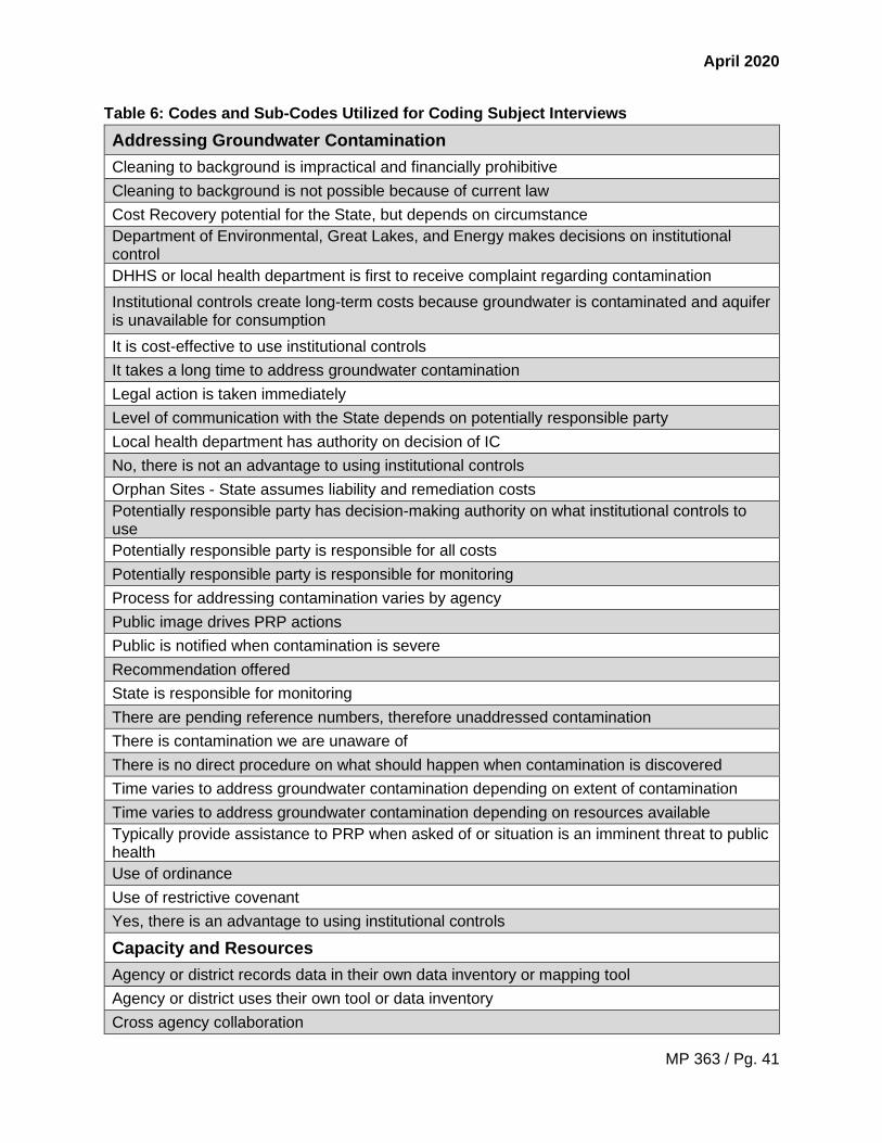
April 2020
MP 363 / Pg. 41
Table 6: Codes and Sub-Codes Utilized for Coding Subject Interviews
Addressing Groundwater Contamination
Cleaning to background is impractical and financially prohibitive
Cleaning to background is not possible because of current law
Cost Recovery potential for the State, but depends on circumstance
Department of Environmental, Great Lakes, and Energy makes decisions on institutional control
DHHS or local health department is first to receive complaint regarding contamination
Institutional controls create long-term costs because groundwater is contaminated and aquifer is unavailable for consumption
It is cost-effective to use institutional controls
It takes a long time to address groundwater contamination
Legal action is taken immediately
Level of communication with the State depends on potentially responsible party
Local health department has authority on decision of IC
No, there is not an advantage to using institutional controls
Orphan Sites - State assumes liability and remediation costs
Potentially responsible party has decision-making authority on what institutional controls to use
Potentially responsible party is responsible for all costs
Potentially responsible party is responsible for monitoring
Process for addressing contamination varies by agency
Public image drives PRP actions
Public is notified when contamination is severe
Recommendation offered
State is responsible for monitoring
There are pending reference numbers, therefore unaddressed contamination
There is contamination we are unaware of
There is no direct procedure on what should happen when contamination is discovered
Time varies to address groundwater contamination depending on extent of contamination
Time varies to address groundwater contamination depending on resources available
Typically provide assistance to PRP when asked of or situation is an imminent threat to public health
Use of ordinance
Use of restrictive covenant
Yes, there is an advantage to using institutional controls
Capacity and Resources
Agency or district records data in their own data inventory or mapping tool
Agency or district uses their own tool or data inventory
Cross agency collaboration

April 2020
MP 363 / Pg. 42
Current record is not or may not be up to date
Data scattered across multiple sources
Experience and use of GIS maps and layers
Experience and use of groundwater contamination data
Frequently used or directed individuals to Environmental Mapper
Have all the data and information necessary to make decisions
Inadequate functionality of data management system
Lack of in situ characterization
Limited funding
Limited staffing
Missing or unavailable data
Obstacles and limitations regarding data availability
State agencies provide resources to PRP
Obstacles
Facilities may refuse to provide data to the State
Inaccurately located contamination site
Lack of partnerships and/or collaborations
Lack of PRP involvement delays process
Lack of state agency involvement
RRD unaware of post closure plan due to voluntary program, non-mandatory report
State lacks legal authority to intervene
State of Michigan may not have up to date information because it is not electronic and/or in District office
Time to address contamination varies frequently
Unaware of exact location and size of plume due to lack of mapped aquifers and potential
Voluntary compliance under NREPA Part 201
Parties or Agencies Notified or Actively Involved
Community members
Consultant
Department of Environmental, Great Lakes, and Energy – Main Office
Department of Health and Human Services
EGLE District Office
Impacted property owner
Local health departments
The project team used NVivo, a qualitative analysis software to code the interviews. To remove
any potential bias during the process, two project team members coded all the interviews
simultaneously. One interview file was lost during the process and is not included in the
interview analysis (note: the specific interview will not be disclosed to ensure anonymity). In

April 2020
MP 363 / Pg. 43
addition, one of the interviews was conducted with two individuals and is therefore being
counted as one interview for analysis purposes and due to limitations of the qualitative software.
Once all the interviews were coded, the results were analyzed using NVivo and Excel software.
Findings
The interviews resulted in a deeper understanding and identification of (1) the value of
institutional controls and (2) the range of obstacles in the way of addressing groundwater
contamination.
1. The Value of Institutional Controls
The following section outlines the interviewees’ perspectives and recommendations on the use
of institutional controls to improve the prevention and management of groundwater
contamination in the State of Michigan. Because the focus of this research is the process of
treating and preventing groundwater contamination, and its decision-making framework, the
project team provides discussion and relevant recommendations in section three (“Discussion
and Recommendations”).
When asked about groundwater contamination, nearly half of interviewees agreed that, because
of current legal statutes, cleaning to natural background is not a viable solution. In addition, 31%
considered it cost-effective to use institutional controls, particularly because of the high cost
associated with cleaning contamination, especially when it is widespread and extensive.
As explained by interviewee P6:
P6: To put it in perspective, to potentially clean up a plume of that [large] magnitude
estimates between $22 and $99 million, and none of those [options] were ever
guaranteed to actually restore the water to uncontaminated levels.
Likewise, interviewee P8 exclaimed:
P8: There’s a big challenge in terms of how clean, clean should be.
With such high costs associated with cleaning contamination, the use of institutional controls
benefits both the state and the responsible party, who can alleviate burdensome costs by
restricting the use of groundwater and therefore continuing to ensure public health. However, it
remains unclear whether the long-term social costs of retaining groundwater contamination will
exceed clean-up cost estimates.
In contrast, 15% of interviewees believe that the responsible party should bear all costs
associated with the contamination. In certain circumstances, however, there are sites with no
viable party responsible for causing or contributing to the contamination. In these cases, the

April 2020
MP 363 / Pg. 44
State of Michigan may take ownership of remediation and clean-up efforts depending on the
severity of the contamination.
Over 50% of interviewees agreed there is no advantage to using institutional controls. On this
subject, several interviewees raised concerns that once institutional controls are in place, there
will be no incentive or requirement to clean up contamination because the responsible party has
adhered to state laws. Similarly, because of NREPA Part 201, a majority of interviewees (60%)
believe there is contamination that the State of Michigan is unaware of. Furthermore, aquifers
are rare and highly valued in the world, leaving contamination in place raises concerns
regarding the long-term social costs associated with the use of institutional controls on these
vital resources. As interviewee P4 explained:
P4: What I am concerned with is that, in some ways, we are writing off aquifers. If we're
not actively cleaning up a groundwater plume, then we are writing off this portion of the
aquifer in perpetuity. I have concerns about that because some of our plumes [and]
contamination sites are very well characterized and some of them are horribly
characterized.
P5: Groundwater is not getting cleaned up.
P1: The downside is that once you put [institutional controls] in place, there is no
incentive to actually clean [contamination] up.
Thirty-one percent of interviewees said there are no direct procedures following contamination
discovery. This is why the project team suggests a decision-making framework to assist the
State as it moves forward in addressing contamination.
2. The Range of Obstacles to Addressing Groundwater Contamination
When asked about data availability and upkeep, 54% of interviewees believe that the current
record is not or may not be up to date. Sixty-two percent of interviewees claimed that the data
needed to address groundwater contamination is scattered across multiple sources. Only 15%
of interviewees said they have all the data and information necessary to make decisions about
addressing groundwater contamination.
Many obstacles to addressing groundwater contamination at the State level relate to capacity
and available resources. Fifty-four percent of interviewees reported limited staffing and missing
or unavailable data and 46% mentioned limited funding. Lack of resources makes mapping
groundwater contamination that much more difficult. Regarding district offices and partnering
agencies, such as DHHS, interviewee P13 exclaimed:
P13: Since we use parcel IDs, it is a large time consumption when we receive data from
the State [EGLE] because there is a list of [one] thousand sites that you're getting, and

April 2020
MP 363 / Pg. 45
you can't just control-find for the parcel number because they don't identify them using
parcel IDs.
The EGLE main office provides a large file of data to its partners; however, EGLE and its
partners use different identifying information, and therefore it is difficult and time intensive for
partners to sort through this information. This reveals a need for more consistent data entry
methodologies by State agencies. This will cut staff time spent finding crucial information,
provide more time to address the contamination, and reduce the potential for inaccuracies which
may cause a site to be overlooked or missed.
In addition, interviewees identified the following factors that prohibited or affected their response
to contamination: Over 60% of interviewees were unaware of the exact location of the
contamination and the size of the plume that was there due to a lack of mapped aquifers.
Although the project team members are aware that contamination moves and is thus difficult to
map, the State of Michigan needs to consider ways to provide up-to-date information through
increased reporting, and updated methodology and technology. Furthermore, 23% of
interviewees recalled that the contamination site was inaccurately located. Similarly, 8% of
interviewees said that facilities refused to provide data about the contamination to the State.
The interviewees did not state how often these inaccuracies occur.
Eight percent of interviewees believe that the State of Michigan may not have current
information on groundwater contamination because the data are not digitized or are located in
the District offices. Although 69% of interviewees acknowledged that the District office is notified
and/or actively involved during contamination, broad and consistent access to data is critical to
efficiency and effectiveness in protecting public health and the environment. Similarly, 38% of
interviews noted that DHHS was notified and/or actively involved in the process of addressing
contamination, while only 23% of interviewees said that EGLE main office in Lansing, MI was
involved. With public health at the crux of these agencies’ missions, the project team believes
that both departments need to be made aware of the issue, no matter the scale of the
contamination.
Furthermore, there appears to be miscommunication about the use of institutional controls
among local health department members and members across agencies. Whereas 15% of
interviewees said that their local health department has authority over which institutional control
is implemented, 85% acknowledged that the potentially responsible party has decision-making
authority over which institutional controls to use. Therefore, it would be useful to clarify in which
circumstances the agency has authority to make decisions, and to increase cross-agency
collaboration and communication when decisions are made.
Finally, none of the interviewees discussed NREPA Part 201 provisions stating that liable
owners and operators are obligated to disclose contamination to the State if a release over a
24-hour period results in a quantity of hazardous substance that meets or exceeds the
reportable quantities as determined by CERCLA. Therefore, although disclosure is required, in
practice it may not occur.
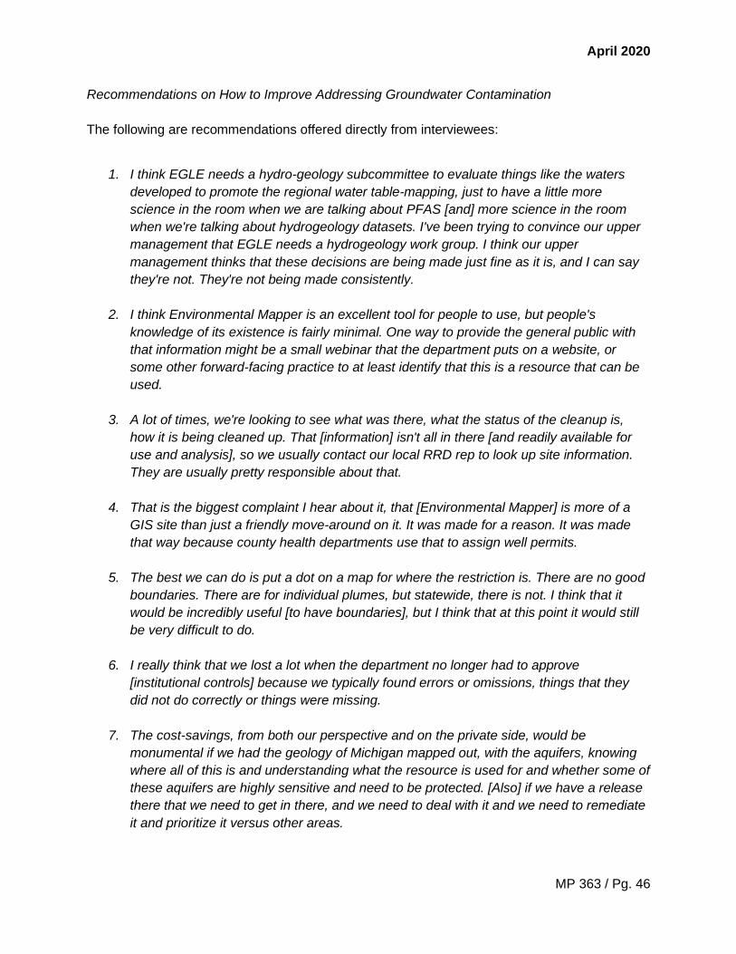
April 2020
MP 363 / Pg. 46
Recommendations on How to Improve Addressing Groundwater Contamination
The following are recommendations offered directly from interviewees:
1. I think EGLE needs a hydro-geology subcommittee to evaluate things like the waters
developed to promote the regional water table-mapping, just to have a little more
science in the room when we are talking about PFAS [and] more science in the room
when we're talking about hydrogeology datasets. I've been trying to convince our upper
management that EGLE needs a hydrogeology work group. I think our upper
management thinks that these decisions are being made just fine as it is, and I can say
they're not. They're not being made consistently.
2. I think Environmental Mapper is an excellent tool for people to use, but people's
knowledge of its existence is fairly minimal. One way to provide the general public with
that information might be a small webinar that the department puts on a website, or
some other forward-facing practice to at least identify that this is a resource that can be
used.
3. A lot of times, we're looking to see what was there, what the status of the cleanup is,
how it is being cleaned up. That [information] isn't all in there [and readily available for
use and analysis], so we usually contact our local RRD rep to look up site information.
They are usually pretty responsible about that.
4. That is the biggest complaint I hear about it, that [Environmental Mapper] is more of a
GIS site than just a friendly move-around on it. It was made for a reason. It was made
that way because county health departments use that to assign well permits.
5. The best we can do is put a dot on a map for where the restriction is. There are no good
boundaries. There are for individual plumes, but statewide, there is not. I think that it
would be incredibly useful [to have boundaries], but I think that at this point it would still
be very difficult to do.
6. I really think that we lost a lot when the department no longer had to approve
[institutional controls] because we typically found errors or omissions, things that they
did not do correctly or things were missing.
7. The cost-savings, from both our perspective and on the private side, would be
monumental if we had the geology of Michigan mapped out, with the aquifers, knowing
where all of this is and understanding what the resource is used for and whether some of
these aquifers are highly sensitive and need to be protected. [Also] if we have a release
there that we need to get in there, and we need to deal with it and we need to remediate
it and prioritize it versus other areas.

April 2020
MP 363 / Pg. 47
8. We haven't invested [in mapping aquifers]. Other states have invested. If you look at
Indiana, Ohio, New Jersey--New Jersey has classified their aquifers. They've got three
tiers of aquifers and have invested. They have taken advantage of federal match money
to do their geological mapping.
9. I think the timing is the biggest issue. I would just like to see [data] in more real-time.
10. It would always be good to see parcel layers [in Environmental Mapper].
With 77% of interviewees using or directing individuals to Environmental Mapper, major themes
from these recommendations include:
• updating data and sources;
• creating a more user-friendly platform that allows for easy navigation of the data;
• adding additional layers of data; and
• training on the use of Environmental Mapper.
Because 23% of interviewees state that their agency or District office records data on
groundwater contamination in their own inventory or mapping tool, the project team believes a
central portal must merge the data to maintain continuity and accuracy. In addition, the project
team believes that mapping the aquifers and contamination as a long-term effort will enable
deeper understanding of the geology of the State of Michigan and the state’s continued effort to
address contamination and protect water resources for future generations.

April 2020
MP 363 / Pg. 48
2.4. Data and Visualizations
Data on groundwater contamination, wells, wellhead protection areas, as well as the geographic
information associated with these datasets are important for tracking and managing the state’s
resources. Maps provide a better visual understanding of geographic patterns of institutional
controls in relation to other demographic and natural resource data. It is important to recognize
that multiple state and local agencies have a hand in managing water resources and
contamination; therefore, state and local agencies rely on the upkeep and sharing of various
data by and with one another. The following section inventories the data available to state and
local agencies on groundwater and groundwater contamination as well as compiles the
geospatial data available to show visual representation in the form of maps.
Data Source Inventory
Through discussions with EGLE and DHHS staff as well as extensive online research, a data
source inventory (Appendix D) was developed to provide an overarching view of the data
available on groundwater contamination and institutional controls in the State of Michigan.
Overview of Applicable Datasets
RRD: All information on institutional controls is managed by RRD and held in its respective
databases (e.g. ERNIE, RIDE). The Environmental Response Networked Information Exchange
(ERNIE) currently hosts all Part 201 and 213 site information and is not public facing, meaning
one must be granted access to view the database. ERNIE has approximately 77,732 entries of
Part 201 and 213 sites; however, its use is being phased out and replaced by the Remediation
Information Data Exchange (RIDE). RIDE is an enhanced data management system and allows
staff to view information on appropriations, authorizations, and grants for sites as well as keep
detailed electronic document records. While RIDE is not currently public facing, RRD plans to
make it public once all records have been transferred from ERNIE. The final database RRD
manages is the Known Environmental Remediation Mapping Information Tracking (KERMIT)
that feeds into Environmental Mapper, an online GIS-based system. Environmental Mapper is
public facing and contains data on institutional controls, baselines environmental assessments,
and notices of corrective action. Other EGLE divisions, state departments, and local health
departments utilize Environmental Mapper for many day-to-day work activities. For example,
local health departments use Environmental Mapper during the well permitting process to
ensure wells are not permitted on a site with groundwater restrictions.
DWEHD: There is no Part 201 data housed in DWEHD databases; however, DWEHD manages
WellLogic, which contains water well and pump records for the entire state. Local health
departments utilize WellLogic in tandem with Environmental Mapper during well permitting. It is
important to note that until January 1, 2000, not all water well records for new wells in Michigan
were entered into WellLogic. Inclusion of wells drilled before 2000 varies from county to county.
WRD: MiWaters is a data management system managed by WRD. This multiuse platform
enables the creation and management of permit applications and service requests, as well as
the ability to report spills, pollution, and unauthorized activities. Further, the public facing

April 2020
MP 363 / Pg. 49
interface allows people to find public notices, hearings, and documents related to permit
applications and search for combined sewer overflow, retention treatment basin, and sanitary
sewer overflow discharge events. Part 201 documents can be found in MiWaters for specific
sites that have facility status; however, Part 201 documents are not readily identifiable in a
search.
Overview of Geographic Information System (GIS) Data
GIS data collected from the State of Michigan, U.S. Census Bureau, U.S. Geological Survey,
and U.S. Department of Agriculture were used to develop thematic maps. Some maps represent
the spatial extent of Michigan’s institutional controls layered over population data or wellhead
protection areas, while others represent geographic patterns in use of institutional controls and
an analysis of statewide vulnerability to contamination. The maps are provided in (Appendix E)
with detailed descriptions and explanations of methodology below. The maps are not meant to
infer causation or correlation, but instead visualize geographic patterns of institutional controls in
relation to other demographic and natural resource data.
To ensure the layers perfectly aligned, each dataset layer used below was geographically
transformed be in the Hotine Oblique Mercator projection as well as the North American Datum
1983. The Hotine Oblique Mercator projection was used because it ensures the least amount of
shape and size distortion, providing the most accurate depiction of the State of Michigan.
Part 201 Sites of Environmental Contamination and Population Density by County
Description: This map shows county population density data overlaid with current Part
201 sites of environmental contamination. Population density and industry are often
positively correlated, as industry relies on a robust transportation and employment
sector. It should be noted that because population density was normalized by county
area, some counties with small cities and large rural areas appear to have overall lower
population density; therefore, these counties may still have contamination hot spots
associated with the small cities. As indicated by the map legend, lighter hues of blue
represent low population density while deeper hues of blue represent high population
density.
Methodology: State of Michigan county data were downloaded from the state’s GIS
Open Data portal, population data were downloaded from the US Census Bureau, and
Part 201 sites of environmental contamination were downloaded from Environmental
Mapper. All three datasets were uploaded to ArcGIS Pro and prepared as separate
layers. To calculate population density, the county and population data was joined by
their unique county ID. After the join, population density was calculated as people per
square mile using the math function. Population density was then symbolized using a
graduated color scheme. The data were classified using natural breaks because it best
represented the variations in the population density data between rural and urban
counties.

April 2020
MP 363 / Pg. 50
Heat Map: Part 201 Sites of Environmental Contamination
Description: This map shows the density of Part 201 sites of environmental
contamination across the State of Michigan. As indicated by the map legend, the density
parameters range from sparse to dense, where the most sparse areas appear light blue
and the most dense areas appear yellow. The most dense areas are in Detroit and
Grand Rapids, while rural areas have more sparse sites.
Methodology: State of Michigan county data were downloaded from the state’s GIS
Open Data portal and Part 201 sites of environmental contamination were downloaded
from Environmental Mapper. All three datasets were uploaded to ArcGIS Pro and
prepared as separate layers. Density of sites was calculated using the kernel density
function in ArcGIS Pro. The kernel density function calculates the magnitude-per-10
square miles from a point. Density was symbolized using a graduated color scheme.
Part 201 Sites of Environmental Contamination and Restrictive Covenants –
Wayne County
Description: This map shows a close up of the Part 201 sites of environmental
contamination and restrictive covenants in Wayne County, Michigan. Given the density
of Part 201 sites in Wayne County depicted in the heat map, it was decided that an
additional map showing the extent of Part 201 sites and restrictive covenants would be
beneficial. While the majority of residents in Wayne County, especially in the City of
Detroit, are provided municipal water from Lake Huron, vapor intrusion remains a
concern for households in the area and could pose a public health risk if not sufficiently
managed. Part 201 sites are depicted by dark red points while restrictive covenants are
shown as purple polygons. The City of Detroit is outlined in light blue for reference.
Methodology: State of Michigan county data were downloaded from the state’s GIS
Open Data portal, and Part 201 sites of environmental contamination and restrictive
covenants were downloaded from Environmental Mapper. All three datasets were
uploaded to ArcGIS Pro and prepared as separate layers. To isolate Wayne County, the
county data was clipped. Additionally, the select by location feature was used to isolate
Part 201 sites and restrictive covenants and create two new layers specific to Wayne
County. Part 201 sites and restrictive covenants were then symbolized using a
categorical color and shape scheme.
Part 201 Sites of Environmental Contamination and Wellhead Protection Areas
Description: This map shows wellhead protection areas in each county in relation to Part
201 sites of environmental contamination. Wellhead protection areas are specific areas
that contribute groundwater to wells serving public water supply systems, which
communities rely on for drinking water. The areas require additional management
strategies to protect public water supply wells from groundwater contamination, which is

April 2020
MP 363 / Pg. 51
why it is particularly important to understand what sites of environmental contamination
may currently exist in or near these areas. As indicated by the map legend, wellhead
protection areas are represented by the light blue polygons and Part 201 sites are dark
red points.
Methodology: State of Michigan county data and wellhead protection areas were
downloaded from the state’s GIS Open Data portal and Part 201 sites from
Environmental Mapper. County and wellhead protection data did not have to be joined
by their unique county ID because each wellhead protection area includes a unique set
of geographic coordinates. Wellhead protection areas and Part 201 sites were then
symbolized using a categorical color and shape scheme.
Vulnerability Index: Surface and Groundwater Contamination
Description: This map shows a vulnerability index for the State of Michigan, identifying
areas that may be at lower or higher risk to surface and groundwater contamination if a
spill of hazardous materials was to occur. The risk index is categorical and varies from
low to high risk. These categories were developed using the slope of the area, soil
drainage, and proximity to a water source (e.g. river, lake). The map provides a general
overview of some of the regions of interest and can be compared with the location of
current restrictive covenants to see where mitigation efforts could take place. As is
shown on the map, the sandier soils of central Michigan have a higher drainage rate and
therefore demonstrate higher vulnerability on the risk index.
Methodology: The vulnerability index was created following a methodology similar to
Bergen (2019).162 Three primary layers were factored into the index: slope, hydrologic
soil group, and distance from hydrological features (i.e. river and lakes). Slope was
derived from a DEM layer downloaded from USGS using the ‘range’ function of a focal
statistics tool. Hydrologic soil groups were obtained from the USDA’s STATSGO2 soil
data set and reclassified as a raster. The hydrological features shapefile obtained from
the State of Michigan’s GIS Open Data portal. Distance from streams was calculated
using the Euclidean distance tool. All layers (slope, soil group, and distance from water)
were reclassified and normalized on a scale of 0-100. Lastly, a raster calculator function
was used to apply the following formula with each variable given a different weight: (Soil
Group * 0.4 + Slope * 0.2 + Proximity to Water * 0.4). The output risk raster was then
categorized into three major groups as based on a natural breaks classification.
162 Bergen, K. et al. “Raster Suitability Mapping – EAS 531 – Principles of Geographic Information Systems.” Fall
2019.

April 2020
MP 363 / Pg. 52
2.5 Groundwater Models
Groundwater modeling is an essential tool for predicting potential impacts of proposed remedial
actions at facilities with environmental contamination.163 Groundwater models are computer
models that use mathematical equations and facility-specific geologic data to simulate local
hydrologic dynamics. These models provide the modeler with a working understanding of how
far and how fast groundwater moves locally and how groundwater contaminants are transported
away from their initial discharge site towards potential downhill sites. When properly calibrated,
groundwater models estimate the fate and transport of groundwater contaminants, which allows
proper design of hydrologic containment and pump-and-treat systems, and evaluation of
groundwater monitoring networks.164 As such, groundwater models are critical components of
Remedial Action Plans submitted to EGLE by parties liable for contamination under Part 201.
Proper modeling of a contaminated area also enables selection of appropriate institutional
controls to mitigate contamination. In the State of Michigan, groundwater modeling efforts are
supported by the Groundwater Modeling Program (GMP), housed within the Remediation and
Redevelopment Division and established in 1980, and funded through federal EPA grants.165
Many models of varying complexity exist to describe the hydrogeological settings of
contaminated sites. Analytical models (e.g., BIOSCREEN, BIOCHLOR, etc.), which return one-
dimensional solutions for groundwater flow and contaminant are most appropriate for sites with
relatively homogeneous hydrogeologic conditions or for preliminary site assessments when high
accuracy is not necessary.166 Analytical Element Models (e.g., GFLOW, WinFlow, etc.) return
two-dimensional groundwater flow solutions and are also appropriate for primary assessments
or sites with minimal hydrogeologic complexity.167 Analytical and Analytics Elements models are
sometimes preferred because they require comparatively little computing power to run.
Modeling assessments where high accuracy is necessary, or on sites with high hydrogeological
complexity, rely on numerical models (e.g., MODFLOW, BIOPLUME II, BIOPLUME III, etc.) that
compute highly complex equations to return three-dimensional groundwater flow solutions.168
Groundwater modeling efforts in Michigan are funded by a mixture of public and private
sources. Groundwater modeling completed by private firms is funded by the party seeking use
of an institutional control to restrict groundwater use or by a person seeking an exemption to
use or install a well within or near a restricted area. Review of these models, completed by
EGLE, is supported by federal and state funds. In rare cases, EGLE may directly fund
groundwater modeling on a site-specific basis for projects undertaken by the agency or in
support of enforcement actions.
To facilitate proper reporting of modeling methods and results EGLE provides guidance
documents (Appendix F). Proper reporting of modeling results is crucial to developing effective
163 Department of Environment, Great Lakes, and Energy. (2014). Groundwater Modeling. (pp. 1–48) 164 Ibid. 165 Ibid. 166 Ibid. 167 Ibid. 168 Ibid.

April 2020
MP 363 / Pg. 53
institutional controls and remediation strategies. Presently the most significant challenge that
EGLE faces with regards to groundwater modeling efforts is the submission of reports that do
not meet the minimum standards outlined by the guidance documents.169 To address this
challenge, EGLE staff have begun rejecting reports lacking the minimum standards and
demonstrated model verification. Accepted submissions are reviewed by a Groundwater
Modeling Technical Assistance and Program Support (TAPS) team, which subsequently
provides recommendations to EGLE district offices that inform final decisions to approve a
proposed institutional control.
Groundwater modeling is not inherently required for all institutional controls. In defining an area
where groundwater restrictions are appropriate for the purpose of restricting potential exposure
to hazardous substances, EGLE’s district technical staff may request that the person proposing
the institutional control perform groundwater modelling to determine the stability of the
groundwater contaminant plume and contaminant fate and transport of hazardous substances
within a groundwater contaminant plume. Responsible party engagement with groundwater
modeling specialists is mandated at the discretion of EGLE technical staff overseeing a specific
project. Any need to develop a groundwater model is determined based on site-specific
information and circumstances of the project. For example, when determining whether use or
installation of a well may result in an unacceptable exposures or influence hazardous substance
fate and transport within an aquifer that degrades groundwater resources, the department may
require groundwater modeling to make recommendations regarding use or installation of a well
within or near a restricted use area. Need to develop a groundwater model is also specific to the
type of institutional control proposed by the responsible party. Restrictive covenants, which
restrict the use of groundwater specific to individual properties, are based on exceedances of
criteria on the property and not any modeling. Groundwater use ordinances, which restrict the
use of groundwater in an area, rely on models to assist in determination of an appropriate buffer
zone.
Once groundwater modeling efforts are finished, no statewide database presently exists to
house and access the completed models. Many groundwater models created by project
consultants working for a PRP ultimately become inaccessible to the state and the public;
consequently, state efforts to build a broad base of modeling knowledge via incorporation of
existing models and the nesting of models at multiple spatial scales are hindered by the present
situation. Therefore, to enable accurate forecasting of groundwater quantity and quality across
the state, a statewide data management system should be developed to house groundwater
models and groundwater data to feed those models.
169 Ibid.

April 2020
MP 363 / Pg. 54
3. Discussion & Recommendations
The research shows that while the 1995 amendments to Part 201 were initially intended to aid in
the redevelopment of brownfield sites and prevent urban sprawl, the law has been used to
further restrict groundwater resources even outside of urban centers and made it harder for the
state to track instances of contamination. Additionally, amendments have increased the burden
of proof necessary to impose liability, loosened standards for BEAs, and allowed liable parties to
choose the type of institutional control used to restrict groundwater use. Therefore, the current
process for detecting and managing contamination as outlined by Part 201 provides a lot of
latitude to owners and operators. Implementation of the statute is further complicated by
language that creates opportunities for contamination to go undetected, both legally and
illegally, and leaves the state with limited response options. The following are three key aspects
of Part 201 that make tracking and response challenging:
• Triggering the Statute: Part 201 Section 14 obligations are only triggered when an
owner/operator becomes “aware” of the contamination. While hazardous substance
releases above the reportable quantity would clearly incite some type of response given
the large quantity released, most of the state’s Part 201 sites are not the result of a
reportable release.
• Establishing Liability: Liable parties are permitted to self-implement cleanup measures
without notifying the state once they become “aware” of the contamination. While liable
parties do need to notify the state if an institutional control is being placed on the
property to mitigate risk, the state has no way to verify if this occurs if they were never
notified of the contamination in the first place.
• Enforcing Obligations: Part 201 does not give EGLE-RRD the authority to force liable
parties to take on specific response activities as long as the response taken sufficiently
mitigates the risk, which is likely to lead to more use of institutional controls than
attempts to fully remediate. Additionally, Part 201 gives EGLE-RRD the ability to enforce
Section 14 obligations on a liable party, but they can only do so when they suspect the
property is a facility. The department may learn of contamination through a BEA or a
complaint, but this is more often long after the release occurred.
These aspects of the statute make it difficult to determine the true extent of groundwater
contamination in the State of Michigan. Without a full picture of the current state of groundwater
contamination, it is difficult to put in place a comprehensive management strategy. Further, it is
impossible to determine the long-run risk and costs that are associated with groundwater
contamination and restricting groundwater use if there is not a complete understanding of where
it is occurring. While institutional controls provide flexibility to owner/operators, allowing them to
maintain operations on contaminated properties if the risk is managed, all instances of
hazardous substance release should be reported to the state. Stricter reporting requirements
would 1) provide better tracking of contamination, allowing the state to comprehensively
measure the long-run economic and social costs of current restrictive management actions and
determine whether Part 201 is most cost effective regulatory framework and 2) improve
decision-making about contaminant response in the future. To change the current process for
groundwater contamination management, EGLE needs more control over the process. To

April 2020
MP 363 / Pg. 55
institute more strict reporting and management requirements where the professional judgement
of EGLE staff sees fit, Part 201 would need to be amended by the legislature.
Michigan is not unique in its process for risk mitigation, as most states follow a similar protocol.
Table 6 summarizes the key differences discussed in Section 2.2 between Michigan, Minnesota,
Wisconsin, and Wyoming. Most notably, none of the states had a requirement for property
owners to disclose contamination if the release was below the reportable quantity and Wyoming
only required disclosure from underground storage tank and radioactive waste operators.
Additionally, all states allowed for the use of institutional controls, but the level of state
involvement (e.g., review and approval) or what institutional controls could be used for varied.
While these states allow for the use of institution controls, the analysis could not measure
whether institutional controls effectively manage groundwater contamination or what the
associated long-run costs are. Michigan is uniquely situated at the center of the Great Lakes
region, which represents 20% of the world’s fresh surface water resources. With 3,288 miles of
Great Lakes coastline and given what is known about ground-surface water interactions (GSI),
contaminated groundwater will eventually interact with surface water. Michigan’s surface waters
are a vital drinking source for citizens and contribute to the state’s economy through tourism and
industry. Knowing this, it is important to have a comprehensive understanding of the state’s
resources through utilizing geologic mapping, key GSI points, and current and potential
contamination sites and pathways.

April 2020
MP 363 / Pg. 56
The interviews resulted in a deeper understanding and identification of the value of institutional
controls and the range of obstacles in the way of addressing groundwater contamination.
Interviewees, who have worked for years on the issue, offered recommendations to improve
prevention and management of groundwater-contamination in the State of Michigan.
Interviewees explained that due to current legal statutes cleaning to natural background is not a
viable solution, though this then increases the long-term social costs of leaving contamination in
place. Institutional controls are valuable because they are cost-effective and mitigate public
health risks. However, there are a range of obstacles, such as tracking and monitoring, to
effectively addressing groundwater contamination. For example, many interviewees exclaimed
that the current datasets needed to address contamination are incomplete or not up to date.
Others stated that limited funding presents challenges to comprehensively mapping Michigan’s
groundwater resources, subsequently making tracking of contaminate movement more difficult.
Interviewees recommended updating data and sources, creating a more user-friendly platform
that allows for easy navigation of the data, adding additional layers of data, and training on the
use of Environmental Mapper. Finally, the project team believes that mapping the aquifers and
contamination as a long-term effort will enable deeper understanding of the geology of the State
of Michigan and the state’s continued effort to address contamination and protect water
resources for future generations.
Given the project team’s interviews with staff and online research, the data available to staff are
disparate across agencies and divisions, most using agency or division specific systems for
collecting and coding data. For example, Environmental Mapper uses site IDs while WellLogic
uses parcel IDs. Because sites are identified differently, sites with institutional controls on them
could be overlooked during the well permitting process; therefore, it would be beneficial if
Environmental Mapper included parcel IDs in its site data. Another example is the MiWaters
database, where most of the outward facing data are housed. Even after a thorough search of
WRD’s website for coding descriptions, the project team was unable to understand what much
of the data were describing. Additionally, some of the datasets were so large that they could not
be downloaded fully without reaching out to WRD for assistance. Lastly, during the project
team’s interviews, some staff mentioned that MiWaters contained information on Part 201 sites.
The project team’s subsequent analysis of the data found it was particularly onerous to identify
sites Part 201 because the documents were housed with the permit documents and not
explicitly identified or searchable.
Given the difficulty in understanding MiWaters data and frustrations indicated to the project
team from staff during interviews, improvements could be made to MiWaters to make it more
user friendly. First, the process for how to download full datasets for review should be outlined
on the MiWaters website. Second, codes should be explicitly laid out in a key or document on
the MiWaters or WRD website. Lastly, it appears that some of the databases are missing
important information, such as addresses or well records, which could further exacerbate issues
with staff from other agencies finding information about a specific site. Missing data can be
attributed to the use of paper records versus electronic records in addition to the fact that not all
district staff provide the same level of detail when entering records into a database. Standard
operating procedures for each division should be developed to ensure that data is being entered

April 2020
MP 363 / Pg. 57
consistently across employees. Further, efforts should be made to ensure missing data is found,
including county health departments making efforts to enter well records prior to 2000 into
WellLogic.
Analysis of groundwater modeling protocols revealed three areas of weakness: lack of sufficient
funding to complete priority modeling, lack of authority to enforce modeling standards, and lack
of statewide database to house and access groundwater models and associated data.
Increased rule-making authority would allow the department to require groundwater models
submitted with Remedial Action Plans to adhere to these standards, ultimately aiding the
creation institutional controls that accurately reflect the state of contamination. Securing
additional funding would empower EGLE to complete modeling on all sites without a PRP to
ensure that all contamination across the state is monitored and potential contamination risks are
fully understood. Developing a statewide database for groundwater models would allow the
state to accumulate modeling knowledge and accurately forecast groundwater quantity and
quality at multiple spatial scales. A plan to create a database that accomplishes these goals has
been proposed to the Water Use Advisory Council. This database, the Michigan Hydrologic
Framework, would facilitate statewide management of both surface and groundwater models
through centralized access to integrated hydrologic models and up-to-date hydrologic data.
Given the discussion and recommendations above, the project team has outlined the
recommendations and organized them based on short- and long-run actions to better track and
manage the state’s groundwater resources:
Short-run Actions
Enhanced data availability and accessibility
a. Environmental Mapper (for EGLE RRD)
i. Include a “Parcel ID layer” in Environmental Mapper to improve
consistency between agencies databases and decrease the amount of
time spent matching sites.
ii. Add date-stamps to all future sites added to Environmental Mapper so
they can start to be tracked over time.
iii. Create and distribute an accessible webinar on the use of Environmental
Mapper so local agencies and the public are able to utilize its full benefits
and understand the information it provides.
b. MiWaters (for EGLE WRD)
i. Develop a guide explaining how to download large data sets so they can
be fully viewed and analyzed in Microsoft Excel or through other data
analysis software.
ii. Develop and include a key for coded data that is accessible to other
agencies and the public so the information shared is able to be
understood.

April 2020
MP 363 / Pg. 58
iii. Create and distribute an accessible webinar on the use of MiWaters so
local agencies and the public are able to utilize its full benefits and
understand the information it provides.
c. WellLogic (for county health departments and DWEHD)
i. County health departments should seek funding to support paper well
record transfers (prior to 2000) to WellLogic. In order to properly manage
groundwater, there needs to be a complete understanding of how many
active and inactive wells Michigan currently has.
d. All Agencies
i. Standard operating procedures should be developed for each agency and
division, if they do not already exist, to ensure that data is being entered
consistently by employees. If standard operating procedures currently
exist, they should be reviewed and updated to ensure the most stringent
record keeping is being maintained. Comprehensive management of
contamination aquifers cannot be maintained if records are missing or
incomplete.
Long-run Actions
Enhanced data availability and accessibility
a. EGLE should seek funding from the legislature to support the mapping of
Michigan’s aquifers and groundwater contamination, beginning with high priority
regions, allowing the state to determine what percentage of groundwater
resources are being restricted or contaminated. This is a vital step in evaluating
the long-term cost of institutional controls.
b. EGLE should develop a statewide data management system to house
groundwater models and groundwater data to feed those models. (Currently,
there is a proposal being considered by the Water Use Advisory Council that
would fund the creation of a Michigan Hydrologic Framework, which the project
team recommends further exploration and funding for.)
c. EGLE district offices should take steps to transfer recordkeeping practices from
paper to electronic in order to facilitate more rapid communication between
agencies.
d. All agencies that handle groundwater and groundwater contamination should
develop a working group to discuss the potential of creating a central portal that
hosts all groundwater contamination data to maintain continuity and accuracy.
Enhanced decision making and resources for management
a. EGLE should seek amendments to Part 201 from the State of Michigan
legislature. The amendments should be guided by the professional expertise of

April 2020
MP 363 / Pg. 59
EGLE staff and written in a way that enables RRD to create and enforce more
stringent rules regarding the process of addressing groundwater contamination.
For example, requiring all instances of hazardous substance releases be
reported to the state. While EGLE could create a framework to determine
whether institutional controls are appropriate for managing groundwater
contamination, without the ability to influence decisions on institutional controls
this knowledge would be of little use.
b. Additional financial and staff resources should be appropriated to EGLE by the
State of Michigan legislature to accomplish the tasks outlined above, which will
increase EGLE’s capacity to address contamination and reduce risks of human
exposure.

April 2020
MP 363 / Pg. 60
Glossary of Terms
Act of God: An unanticipated grave natural disaster or other natural phenomenon of an
exceptional, inevitable, and irresistible character, the effects of which could not have been
prevented or avoided by the exercise of due care or foresight.
All Appropriate Inquiry: An evaluation of environmental conditions at a property at the time of
purchase, occupancy, or foreclosure that reasonably defines the existing conditions and
circumstances at the property in conformance with 40 CFR 312.
Baseline Environmental Assessment: A written document that describes the results of an all
appropriate inquiry and the sampling and analysis that confirm that the property is a facility.
Conservation Easements: Legal documents filed in the local county deed registry that grant a
governmental entity, charitable or educational association, corporation, trust, or other legal
entity the ability to legally restrict property owners from significantly modifying the present state
of an area of land (e.g. by property redevelopment).
Continuing Obligations: Legal requirements and apply to a property even after the ownership
changes.
Due Care Obligations: Actions that are necessary to protect against human exposure to
contamination in soil, groundwater, and subsurface vapor. Actions must be taken to ensure safe
use of property that is contaminated and that affected parties are properly notified if there is a
likelihood of exposure (e.g. contamination migration onto another an adjacent property.
Easements: Legal documents granting the holder, not necessarily the property owner, the right
to use (affirmative) or restrain (negative) use an area of land.
Environment: Land, surface water, groundwater, subsurface strata, air, fish, wildlife, or biota
within this state.
Environmental Contamination: The release of a hazardous substance, or the potential
release of a discarded hazardous substance, in a quantity which is or may become injurious to
the environment or to the public health, safety, or welfare.
Facility: Any area, place, parcel or parcels of property, or portion of a parcel of property where
a hazardous substance in excess of the concentrations that satisfy the cleanup criteria for
unrestricted residential use has been released, deposited, disposed of, or otherwise comes to
be located.
Groundwater: Water in saturated zone or stratum beneath the surface of land or water.

April 2020
MP 363 / Pg. 61
Hazardous Substance: Any substance that the department demonstrates, on a case by case
basis, poses an unacceptable risk to the public health, safety, or welfare, or the environment,
considering the fate of the material, dose-response, toxicity, or adverse impact on natural
resources.
Institutional Controls: Non-engineered instruments such as administrative and
legal controls that help minimize the potential for human exposure to contamination and/or
protect the integrity of the remedy. Used synonymously with land and/or resource use
restriction(s).
Joint and Several Liability: When two or more parties are jointly and severally liable for a
tortious act, each party is independently liable for the full extent of the injuries stemming from
the tortious act.
Local Government Controls: A variety of tools used to control land use by local governments.
These include: planning and zoning maps, subdivision plats, building permits, siting restrictions,
groundwater use restrictions via drilling prohibitions or well-use permits.
Operator: A person who is in control of or responsible for the operation of a facility.
Ordinances: Legislation enacted by a municipal authority. Zoning ordinances regulate
permitted land-use practices while subdivision ordinances regulate land-use conversions.
Orphan Sites: A contaminated site that is no longer owned by the original liable party.
Owner: A person who owns a facility.
Per- and Polyfluoroalkyl Substances: Group of man-made chemicals that includes PFOA,
PFOS, GenX, and many other chemicals, which can be found in many products, including food
packaging, household cleaners and nonstick cookware.
Postclosure Plan: A postclosure agreement is developed between EGLE and the liable party
when additional remediation or monitoring is required at the facility after the initial response
activities have been conducted and financial assurance is needed. The agreement must include
the liable party’s plans for monitoring, operating, and maintaining the effectiveness of the
remedial actions in addition to financial assurance to pay for those plans.
Potentially Responsible Party: Means any person who may be liable pursuant to section
107(a) of CERCLA, 42 U.S.C. 9607(a), for response costs incurred and to be incurred by the
United States not inconsistent with National Contingency Plan.
Release: Includes, but is not limited to, any spilling, leaking, pumping, pouring, emitting,
emptying, discharging, injecting, escaping, leaching, dumping, or disposing of a hazardous

April 2020
MP 363 / Pg. 62
substance into the environment, or the abandonment or discarding of barrels, containers, and
other closed receptacles containing a hazardous substance.
Remedial Action: Includes, but is not limited to, cleanup, removal, containment, isolation,
destruction, or treatment of a hazardous substance released or threatened to be released into
the environment, monitoring, maintenance, or the taking of other actions that may be necessary
to prevent, minimize, or mitigate injury to the public health, safety, or welfare, or to the
environment.
Restrictive Covenant: An enforceable promise between the state and property owners to
refrain from certain land use practices or maintain an exposure barrier (e.g. clay cap, parking
lot). Restrictive covenants are executed by documents filed in the local county deed registry.
Strict Liability: In both tort and criminal law, strict liability exists when a defendant is liable for
committing an action, regardless of what his/her intent or mental state was when committing the
action.
Acronyms
CERCLA Comprehensive Environmental Response, Compensation and Liability Act
DNR Department of Natural Resources
DWEHD Drinking Water and Environmental Health Division
EGLE Department of Environment, Great Lakes, and Energy
EPA Environmental Protection Act
ERNIE Environmental Response Networked Information Exchange
KERMIT Known Environmental Remediation Mapping Information Tracking
MDARD Department of Agriculture and Rural Development
MDOT Department of Transportation
MEDC Michigan Economic Development Corporation
MERA Michigan Environmental Response Act
MERLA Minnesota Environmental Response and Liability Act
MHHS Department of Health and Human Services
MPCA Minnesota Pollution Control Agency
NREPA Natural Resources and Environment Protection Act
OGL Office of the Great Lakes
RIDE Remediation Information Data Exchange
RRD Remediation and Redevelopment Division
SCC Stream Control Commission
WDEQ Wyoming Department of Environmental Quality
WEQA Wyoming Environmental Quality Act
WiDNR Wisconsin Department of Natural Resources
WRD Water Resources Division

April 2020
MP 363 / Pg. 63
Works Cited Adams, W. C. (2015). Conducting Semi-Structured Interviews. Handbook of Practical Program
Evaluation, 492–505. DOI: 10.1002/9781119171386.ch19. Audio/Video/Digital Recordings of Research Participants. (n.d.).
<https://www.umass.edu/research/guidance/audio-recordings-research-participants>. Bails, J. (1995). “Will New Polluter Pay Law Help Michigan's Older Urban Areas?”
<https://www.publicsectorconsultants.com/1995/06/02/will-new-polluter-pay-law-help-michigans-older-urbanareas/Saichon>.
Cherkauer K.A., Sinha T. (2010). Hydrologic impacts of projected future climate change in the
Lake Michigan region. Journal of Great Lakes Research 36:33-50. DOI: 10.1016/j.jglr.2009.11.012.
Colten, C. (1991). A Historical Perspective on Industrial Wastes and Groundwater
Contamination. Geographical Review, 81(2), 215-228. doi:10.2307/215985 Colten, C. “Groundwater Contamination: Reconstructing Historical Knowledge for the Courts.”
Applied Geography, vol. 18, no. 3, Elsevier Ltd, 1998, pp. 259–73, doi:10.1016/S0143-6228(98)00017-4.
Congressional Research Service. “Regulating Drinking Water Contaminants: EPA PFAS
Actions.” August 6, 2019. <https://fas.org/sgp/crs/misc/IF11219.pdf> Comprehensive Environmental Response, Compensation, and Liability Act (CERCLA). 42 U.S.
Code Chapter 103. <https://uscode.house.gov/view.xhtml?path=/prelim@title42/chapter103&edition=prelim>
Dempsey, D. (2018) The Sixth Great Lake: The Emergency Threatening Michigan's
Overlooked Resource. F.L.O.W. <https://flowforwater.org/wp-content/uploads/2018/09/FLOW-Groundwater-Report-2018.pdf>
Dempsey, D., (2019). “Michigan Groundwater Policy: A History.” FLOW, 15 Mar. 2019,
<https://www.flowforwater.org/michigan-groundwater-policy-history/> Deutsch, M,. Ground-Water Contamination and Legal Controls in Michigan. United States
Department of the Interior, Geological Survey, 1963. English, M. R., & Inerfeld, R. B. (1999). Institutional controls for contaminated sites: Help or
hazard. Risk, 10, 121. Fereday, J., & Muir-Cochrane, E. (2006). Demonstrating Rigor Using Thematic Analysis: A
Hybrid Approach of Inductive and Deductive Coding and Theme Development. International Journal of Qualitative Methods, 5(1), 80–92. DOI: 10.1177/160940690600500107.

April 2020
MP 363 / Pg. 64
Malewitz, Jim. (2018). “Michigan has 7,300 toxic sites. Money for cleanups is almost gone.” Bridge Magazine. <https://www.bridgemi.com/michigan-environment-watch/michigan-has-7300-toxic-sites-money-cleanups-almost-gone>
Michigan Department of Environment, Great Lakes, and Energy; Drinking Water &
Municipal Assistance Division. <https://www.michigan.gov/documents/deq/deq-wd-gws-wcu-groundwaterstatistics_270606_7.pdf>
Michigan Department of Environment, Great Lakes, and Energy. “Environmental Mapper.”
<https://www.mcgi.state.mi.us/environmentalmapper/> Michigan Department of Environment, Great Lakes, and Energy - Remediation and
Redevelopment Division, Administrative Rules <https://dtmb.state.mi.us/ORRDocs/AdminCode/1716_2017-041EQ_AdminCode.pdf>
Michigan Department of Environment, Great Lakes, and Energy. “What is Due Care and what
are Your Obligations?” <https://www.michigan.gov/egle/0,9429,7-135-3311_4109_59851-267154--,00.html>
Michigan Environmental Response Act (MERA). Act 307 of 1982, Repealed.
<http://www.legislature.mi.gov/(S(gulwn03cygsk2xxxxa5thwnx))/mileg.aspx?page=getobject&objectName=mcl-Act-307-of-1982>
Michigan House of Representatives, Special Ad Hoc Committee on Revitalizing Our Michigan
Cities. Citizen Advisory Group, Findings and Recommendations State Environmental Policies. January 1993. State of Michigan Library. Print.
Michigan Natural Resources and Environmental Protection Act (NREPA), Part 201:
Environmental Remediation. Act 451 of 1994. <http://www.legislature.mi.gov/(S(bv1hctalhlr4ddujvbcdtl1o))/mileg.aspx?page=GetObject&objectname=mcl-451-1994-II-7-201>
National Ground Water Association, 601 Dempsey Rd., Westerville, OH 43081-8978.
<https://www.ngwa.org/docs/default-source/default-document-library/states/mi.pdf> Schnapf, L. P. (2002). How to Use Institutional Controls for Contaminated Sites (pp. 25-37,
Rep.). <https://www.environmental-law.net/wp-content/uploads/2011/09/ICs-and-Contaminated-Sites.pdf>
Stiles, C. W. Experimental bacterial and chemical pollution of wells via groundwater, and the
factors involved. No. 147. US Government Printing Office, 1927. United States Geological Survey, Estimated Use of Water in the United States in 1995, Circular
1200, 1998. United States Census Bureau. “QuickFacts.” Updated: 2019.
<https://www.census.gov/quickfacts/fact/table/US/PST045219>

April 2020
MP 363 / Pg. 65
United States Environmental Protection Agency. “Memorandum: Bona Fide Prospective Purchasers and the New Amendments to CERCLA.” May 31, 2002. <https://www.epa.gov/sites/production/files/documents/bonf-pp-cercla-mem_0.pdf>
United States Environmental Protection Agency. “Consolidated List of Chemicals Subject to
EPCRA, CERCLA, and CAA.” June 2019. <https://www.epa.gov/sites/production/files/2015-03/documents/list_of_lists.pdf>
United States Geological Survey. “Water Use Data for the Nation.” Updated: 2015.
<https://waterdata.usgs.gov/nwis/water_use/> Minnesota Pollution Control Agency. “MN Wells.”
<https://mpca.maps.arcgis.com/apps/View/index.html?appid=4ab8c82e20c24182b56f6b
608d42a602&extent=-93.1182,44.8076,-92.7378,44.9861>
Minnesota Environmental Response and Liability Act. Chapter 15B.
<https://www.revisor.mn.gov/statutes/cite/115B>
Winter, T. C., Harvey, J. W., Franke, O. L., & Alley, W. M. (1998). Ground water and surface
water; a single resource (No. 1139). US Geological Survey.
Wisconsin Department of Natural Resources. “Remediation and Redevelopment Database.”
<https://dnr.wi.gov/topic/Brownfields/wrrd.html>
Wisconsin Department of Natural Resources. “Open Data – Continuing Obligations.”
<https://data-wi-dnr.opendata.arcgis.com/datasets/continuing-obligations-apply>
Wisconsin Groundwater Protection Standards. Chapter 160.
<https://docs.legis.wisconsin.gov/statutes/statutes/160/32>
Wisconsin Remedial Action Statute. Chapter 292.
<http://docs.legis.wisconsin.gov/statutes/statutes/292.pdf>
Wyoming Department of Environmental Quality – Voluntary Remediation Program. “Institutional
Controls, Engineering Controls, and Use Control Areas.” May 2016.
<http://deq.wyoming.gov/media/attachments/Solid%20%26%20Hazardous%20Waste/Vo
luntary%20Remediation%20Program/Fact%20Sheets/FS_23.pdf>
Wyoming Public Health and Safety Statute. Chapter 35.
<http://wyoleg.gov/statutes/compress/title35.docx>
Wyoming Water Development Office. “River Basin Available Groundwater Determination
Technical Memorandum.” <http://waterplan.state.wy.us/basins/7basins.html>

April 2020
MP 363 / Pg. 66
Appendices
A. Draft RFP: Economic analysis of long run risk management for groundwater resources
B. Project Team Full Interview Questions with Probes
C. Project Team Discussion Questions
D. Data Source Inventory
E. Thematic Maps
F. Suggested Groundwater Model Documentation Report Format

Appendix A.

Draft – March 19, 2020
1
MICHIGAN GREAT LAKES PROTECTION FUND
REQUEST FOR PROPOSALS:
ECONOMIC ANALYSIS OF LONG RUN RISK MANAGEMENT FOR GROUNDWATER
RESOURCES
I. Overview
This is a request for proposals for a research project to assess the long-term economic cost
of using institutional controls and other restrictive management actions to manage risks
associated with groundwater contamination compared with the cost of other potential
management actions. EGLE will fund a project to use economic case studies to evaluate the
Michigan Department of Environment, Great Lakes, and Energy’s (EGLE) current process
and criteria for determining when institutional controls are the appropriate response to a
groundwater contamination event.
This research project will evaluate a set of case studies to determine the cost of past uses of
institutional controls and restrictive covenants and develop a decision-making framework for
future instances of groundwater contamination based on a holistic prediction of long-term
risk and cost. The project will seek to incorporate the risk of additional unexpected costs into
this framework as well as changes in risk associated with expected demographic change
and the cumulative risk of using institutional controls at many sites within the same
geographic area. The grantee will be expected to:
a) Identify a set of case study sites where institutional controls have been used to
manage risks associated with groundwater contamination. These cases should
include sites where institutional controls have resulted in 1) low or no unexpected
costs; 2) moderate unexpected costs; and 3) high unexpected costs.
Case study site selection will be led by the grantee and will occur in consultation with
EGLE staff after the grant has been awarded. The applicant is not expected to
identify case study sites in the proposal but should identify some criteria or a
methodology for selecting sites.
b) Evaluate the full economic cost of using institutional controls from the time of
contamination to the present, including projections of future costs where feasible.
c) Compare this cost to the cost that was estimated when institutional controls were
selected as the management option and to the cost of other potential management
actions; and
d) Develop a decision-making framework to help EGLE determine when it is
appropriate to use institutional controls and other restrictive management actions as
opposed to more thorough removal of contamination from the environment, based on
the anticipated economic cost of each option. This calculation should incorporate the
risk of additional unexpected costs, changes in risk associated with expected

Draft – March 19, 2020
2
demographic change, and the cumulative risk of using institutional controls at many
sites within the same geographic area.
Approximately $350,000 from the Michigan Great Lakes Protection Fund (MGLPF) will be
provided to one applicant. This grant program will be funded by the MGLPF and
administered by EGLE. Eligible applicants include: educational institutions; federal, state,
tribal and local governments; and any other non-profit or for-profit entity with relevant
experience.
II. Background
When groundwater becomes unusable due to contaminants exceeding applicable criteria,
there are a number of adaptation and mitigation strategies available to manage the risk
associated with the contamination. Section 324.20121 of Part 201 and Section 324.21310a
of Part 213 of the Natural Resources and Environmental Protection Act (NREPA), Act 451 of
1994 authorizes the use of restrictive covenants and institutional controls to limit use of an
aquifer to manage risk of exposure in lieu of actually removing contamination from the
ground. In some cases, this may constitute a de facto permanent removal of that aquifer, or
portions thereof, from use.
According to the Cleanup Criteria Requirements for Response Activity rules developed by
the Remediation and Redevelopment Division, an
“institutional control” (R 299.1, Rule 1 (q)) is “a
measure which is approved by the department,
which takes a form other than restrictive covenant,
and which limits or prohibits certain activities that
may interfere with the integrity or effectiveness of a
remedial action or result in exposure to hazardous
substances at a facility, or which provides notice
about the presence of a hazardous substance at a
facility in concentrations that exceed only an
aesthetic-based cleanup criterion.” In addition, Rule
299.2(a) defines land or resource use restrictions
that may limit or restrict certain activities that may
result in exposure to hazardous substances at a
facility.
Institutional controls and other land or resource use
restrictions have become a common mechanism for
managing risk associated with groundwater
contamination since the passage of NREPA and are
currently in use at over 2,000 sites across the state. The costs and risks at these sites have
many dimensions that have significantly altered the benefit structure of using institutional
controls and restrictive covenants as a risk management option. In some of these cases,
unexpected complications, like vapor intrusion, have occurred many years after the initial
Table 1
Potential Economic Costs
• Drinking water adaptation
• Ongoing monitoring
• Fish and wildlife
contamination
• Decreased property value
• Health impacts
• Contaminant migration
• Vapor intrusion
• Venting to surface water
• Forgone recreational use
• Risk of additional
complications

Draft – March 19, 2020
3
risk management decision was made and have significantly increased the cost of using
institutional controls. In other cases, contaminants have migrated to affect additional
populations, also significantly increasing the cost of using institutional controls. All of these
dimensions should be considered when calculating the costs and risks of using institutional
controls and restrictive covenants as part of this project. A longer (but not necessarily
comprehensive) list of potential economic costs is available in Table 1.
Michigan’s current environmental laws do not provide guidelines or limitations on the
appropriate use of these mechanisms, nor do they account for the potential complications
described above. As a result, the long-term implications, risks, and costs of using
institutional controls and other restrictive management actions are not well understood. This
research project is intended to augment decision-making by addressing this information gap.
III. Deliverables
The deliverables of the project should be:
• An assessment of the cost of using institutional controls at each of the case study
sites, compared to the cost that was expected at the time of implementation and the
cost of other potential management actions, where information is available.
• An estimation of the total cumulative cost of using institutional controls in the 25
years since they became a common mechanism for managing groundwater
contamination, extrapolated from the case study evaluations.
• A decision-making framework or set of criteria to help EGLE determine when it is
appropriate to use institutional controls and other restrictive management actions as
opposed to more thorough removal of contamination from the environment at a given
site, based on the anticipated economic cost of each option.
EGLE and other State of Michigan project partners expect to work closely with research
team. The team may also be asked to periodically consult with an expert panel about the
methods and conclusions of the project.
IV. Funding Availability
A. Eligible Applicants
• Non-profit and for-profit entities with experience in socio-economic case study
analysis
• Educational institutions
• Federal, state, tribal and local units of government
Note: Grants cannot be made out to individuals.
B. Ineligible Applicants
An applicant for whom any of the following conditions existed in the 12 months prior to the
application deadline for this RFP is not eligible for funding:
• EGLE grant contract terminated

Draft – March 19, 2020
4
• Unresolved EGLE enforcement actions
• History of inability to manage or meet EGLE contractual terms and conditions
C. Grant Amount
Approximately $350,000 will be made available for this grant.
D. Match Requirement
Match is not required but will be considered. Match may be in the form of cash, in-kind
services, or donations.
E. Project Award Period
Projects will be evaluated on project readiness and feasibility for completion within an 18-24-
month time frame beginning October 1, 2020 and ending no later than September 30,
2022.
F. Ineligible Uses for Grant Funds
This grant cannot be used to fund professional development activities or large-scale
purchasing of equipment. This grant is intended to fund research on existing uses of
institutional controls; it cannot be used to fund planning or implementation of future
remediation projects. This grant cannot be used to purchase equipment to be used for
purposes other than the proposed project tasks. Travel expenses should be built into the
proposal budget.
G. Application Deadline
Complete applications must be received no later than 5:00 p.m. on Friday, May 15, 2020.
Save the date for a webinar about the funding opportunity on Wednesday, April 8.
H. Application Submittal
Applications should be submitted by e-mail. Attach the application package in Portable
Document Format (PDF). The combined size of the files attached to the e-mail cannot
exceed 10 megabytes.
Applications should be sent to:
Ms. Kimber Frantz
V. Information for Applicants
Proposal information will not be kept confidential. Grant proposals are considered public
information under the Michigan Freedom of Information Act, PA 442 of 1976, as amended.
Successful applicants will be required to enter into a grant agreement with EGLE with
standard terms and conditions which are not subject to modifications. Failure of a successful
applicant to accept these obligations will result in cancellation of the grant award.

Draft – March 19, 2020
5
Successful applicants will also be required to provide proof of a successful financial audit for
a period ending within the 24 months immediately preceding the proposal due date.
VI. Application Package
Applications can be no more than 10 single-sided pages in length with text no smaller than
10-point font size and standard 1-inch margins. Maps and illustrations may be included but
will be subject to the overall application length limit. A cover letter signed by an authorized
representative of the applicant on the applicant’s letterhead must accompany the application
but will not be included in the page limit. Applications should be addressed as described
below.
A. Application Cover Page
The cover page should be addressed to Ms. Emily Finnell, EGLE, Office of the Great Lakes
Senior Advisor and Strategist, and should list the project title and information about the
applicant. It must clearly state the grant amount requested, match amount provided, if
relevant, and total project cost, if greater than the sum of the grant and match amounts.
Information about the applicant must include:
• Applicant agency or organization name and mailing address
• Authorized representative’s name, e-mail address, and telephone number
• Applicant Federal ID#
• Applicant DUNS #
• Name, title, and contact information of contact person, if different from that of
applicant’s authorized representative
• Congressional District, State Senate District, and State House District numbers of
applicant’s location
B. Proposed Project Summary
Provide a brief summary (300 words or less) of the proposed project including the name of
the applicant organization and partners, proposed methodology and justification for
selection, and the focus and primary outcomes of the project.
C. Detailed Proposed Project Description
The following information is required in the detailed proposed project description:
• Project scope, why the project is needed, and how it addresses the focus of the grant
request
• A brief overview of the planned approach and methodology for carrying out the
project
• List of deliverables
• Source of match, if applicable
D. Project Tasks and Schedule
Display timelines for major tasks, target milestones for critical intermediate and final
products, and key project outcomes/deliverables. The schedule must show that all tasks will
Draft – March 19, 2020
6
be completed within the project period. Progress will be reported semi-annually according to
the table below.
Tasks Oct 2020-
Mar 2021
Apr-Sept
2021
Oct 2021-
Mar 2022
Apr-Sept
2022
Outcome/Deliverable
1.
2.
3.
4.
5.
E. Organizational Capability
Describe the qualifications of the individual(s) anticipated to work on the project and the past
experience of the applicant in managing grant projects. Provide a brief overview of
individual(s)’ publications on related topics.
F. Detailed Project Budget
Download and use one of the budget forms below, based on your organization’s approach
toward project indirect costs. Reimbursement of indirect is optional and at the discretion of
the grantee. Should the grantee choose to request reimbursement of indirect, rates will be
calculated according EGLE policy 10-005, described below:
• The indirect rate established for the grantee organization, up to a maximum of 20
percent of the salary plus fringe costs.
• EGLE maintains the right to ask for verification of how indirect rates are determined.
Select one of the following budget forms:
• Please utilize this budget form if the project does not require any reimbursement of
indirect costs: [link]
• Please utilize this budget form if the project requires reimbursement of indirect costs.
This budget form will allow the applicant to select an indirect rate, not to exceed
EGLE’s mandated 20% cap: [link]
The completed budget spreadsheet file should be included in the e-mail with the application
and will not count toward the 10-page application limit. Within the 10-page document, please
provide a budget narrative that describes each line item.
G. Project Outcomes and Deliverables
Provide a description of the expected results of the project and project deliverables.
VII. Attachments
A. Proof of successful financial audit
B. Proof that applicant is not on the federal/debarment list (sam.gov)

Draft – March 19, 2020
7
VIII. Evaluation Criteria
EGLE strongly encourages interested applicants to contact program staff early in the
proposal development process for assistance and guidance. Complete applications will be
evaluated for funding based on the following considerations:
• Detailed description of proposed methodology for thoroughly evaluating the total
economic cost of past uses of institutional controls, including some projected future
costs
• Detailed description of a thoughtful, creative, and holistic approach for developing a
decision-making framework to assess appropriate use of institutional controls at the
onset of contamination in the future.
• Interdisciplinary capacity of project team, including economic and hydrogeologic
expertise
• Extent to which the project leverages other financial, information, and intellectual
resources
• Feasibility for completion of project within the specified grant period
• Overall quality and clarity of the application
• Organizational capability of the applicant to complete the project as proposed
• Cost-effectiveness
• Measurability of project results
IX. Reporting Requirements and Funding Disbursement
The grantee must complete and submit semi-annual financial and/or progress reports
according to a form and format prescribed by the State and must including supporting
documentation of eligible project expenses.
X. Program Contact
If you have any questions or comments regarding the program or the application process,
please contact:
Ms. Emily Finnell
Office of the Great Lakes
Department of Environment, Great Lakes, and Energy
(c): 517-599-1330
Ms. Christina Pastoria
Office of the Great Lakes
Department of Environment, Great Lakes, and Energy
(c): 517-899-5174

Appendix B.

Interview Questions
1. Do you have any questions for us about the project before we get started? 2. Please tell us a little bit about your work with _____________ (name of agency/division) 3. Can you tell us briefly the role your agency/division plays in addressing groundwater
contamination? 4. Why did you decide to engage in this project?
The following questions will be based on your professional experience.
1. Have you used and/or had experience with institutional controls and other restrictive
management actions during your time at _____________ (name of agency/division)?
a. Probe: What types of controls did you use or come in contact with?
2. Can you walk us through the process of how groundwater contamination, from the
moment of release to the time when all action is complete, is handled?
3. Probe: In what instances institutional controls may be implemented?
a. Probe: What is your role?
b. Probe: Who is involved in the process?
c. Probe: Who makes the ultimate decision that institutional controls are
appropriate?
i. Probe: What other agencies are involved?
ii. Probe: Is the community actively involved or aware?
d. Probe: What is the notification process for groundwater contamination?
e. Probe: What is the notification process for initiating use of institutional controls?
f. Probe: Are there common breakdowns points in the process?
i. Probe: If so, where? (i.e., where, if anywhere, is the process most likely to
fail)
4. In your professional opinion, what are the advantages of using institutional controls?
a. Probe: What is your opinion on the process for appropriate use of institutional
controls?
The following set of questions will be on data availability at your agency
1. Do you use agency and/or division data sets to support your work addressing
groundwater contamination?
a. Probe: If yes, which data sets do you use?
[If they indicate a data set, we have not discussed, ask questions Q2a. through Q2f.;
otherwise, move on to Q3.]
2. Can you provide us more detail on _________ data set(s)?
a. Probe: What is the size of these data sets?
b. Probe: How frequently do you access them?
c. Probe: Who else has access to these data sets?
d. Probe: When and how frequently are these data sets updated?
i. Probe: Who is making these changes?
e. Probe: Where is the information from these data sets gathered?
f. Probe: Where are these data sets located?

3. How is the data used to support your work?
a. Probe: Is it used in reports, press releases, or notifications to communities?
b. Probe: Is it shared with agencies involved in the process?
4. Does your work ever require you to seek information or data from other divisions or
agencies?
a. Probe: If yes, how often do you seek information or data from other divisions or
agencies?
b. Probe: If yes, what information are you requesting and which agencies and/or
divisions are you requesting it from?
5. Is there any data that is unavailable or missing?
6. Is there any data or information that you believe should be included or collected that
currently is not?
a. Probe: Is there a reason why this information is not included?
Ending Questions
1. Is there anything else you would like to share that you feel would help inform our
research?
2. Are there any additional individuals or divisions you would recommend we reach out to
in order to further inform our research?

Appendix C.

Discussion Questions
1. Do you have any questions for us about the project before we get started? 2. Please tell us a little bit about your work with _____________ (name of agency/division) 3. Can you tell us briefly the role your agency/division plays in addressing groundwater
contamination? 4. Why did you decide to engage in this project?
The following questions will be based on your professional experience.
1. Have you used and/or had experience with institutional controls and other restrictive
management actions during your time at _____________ (name of agency/division)?
2. Can you walk us through the process of how groundwater contamination, from the
moment of release to the time when all action is complete, is handled?
3. In your professional opinion, what are the advantages of using institutional controls?
The following set of questions will be on data availability at your agency
1. Do you use agency and/or division data sets to support your work addressing
groundwater contamination?
a. If you answered yes to question 1, please provide us with more detail on the data
sets.
2. How is the data used to support your work?
3. Does your work ever require you to seek information or data from other divisions or
agencies?
4. Is there any data that is unavailable or missing?
5. Is there any data or information that you believe should be included or collected that
currently is not?
Ending Questions
1. Is there anything else you would like to share that you feel would help inform our
research?
2. Are there any additional individuals or divisions you would recommend we reach out to
in order to further inform our research?

Appendix D.

Data Source Inventory_Draft3_02-29-20.xlsx Databases
Information Provided
Name of Database NicknameAgency/Division Owner of Database
Agency/Division Contact Description
Number of Entries in Database
Regularity of Updates
Database Traffic
Part 201 Sites
Groundwater Contamination
Documents (e.g. remediation plans, notices)
Environmental Response Networked Information Exchange ERNIE EGLE/RRD Sara Pearson
Part 201 and 213 site information; use is being phased out and replaced by RIDE. Very simplified interface with limited information (e.g. does not contain particular site documents). 77,732 Weekly/Daily
Unknown; 250 staff with access Y Y Y
Known Environmental Remediation Mapping Information Tracking KERMIT EGLE/RRD Nick Ekel
Holds all information on Part 201 sites in Michigan and feeds into Environmental Mapper (online GIS-based system). See GIS Data Layers tab for more information on data housed in KERMIT. 7,000 Weekly/Daily
Unknown; 250 staff with access Y Y N
Remediation Information Data Exchange RIDE EGLE/RRD Sara Pearson
New system that will hold all RRD data (include Part 201, Part 213, etc.). Can view information on appropriations, authorizations, contacts, contaminant classes, grants, locations, and maintenance. See RIDE tab for more detailed information. See RIDE tab. Weekly/Daily
Unknown; 250 staff with access Y Y Y
Well Logic Well Logic EGLE/DWEH
Contains water well and pump records and abandoned well plugging records by county. Various layers and levels of data available - see WellLogic tab for more detailed information. See WellLogic tab. Monthly Unknown N N Y
MiWaters MiWaters EGLE/WRD
Multiuse platform:- Use to create and manage permit applications and service requests - Find public notices, hearings, documents related to Water Resources permit applications- Search for combined sewer overflow, retention treatment basin, and sanitary sewer overflow discharge events- Report spills, pollution, and unauthorized activities
349,658 Unknown Unknown N N Y

Data Source Inventory_Draft3_02-29-20.xlsx MiWaters
Information Provided
Name of Database NicknameAgency/Division Owner of Database Agency/Division Contact Description
Number of Entries in Database
Regularity of Updates
Database Traffic Part 201 Sites
Groundwater Contamination
Documents (e.g. remediation plans, notices)
MiWaters MiWaters EGLE/WRD
Multiuse platform:- Use to create and manage permit applications and service requests - Find public notices, hearings, documents related to Water Resources permit applications- Search for combined sewer overflow, retention treatment basin, and sanitary sewer overflow discharge events- Report spills, pollution, and unauthorized activities
349,658 Daily Unknown N N Y
Name of Dataset Description Number of Entries Notes
Affils
Unknown; includes site ID, site address, and type of affiliation (e.g. permit, contract) 1,048,576
*could not download entire file because it was too large
SitesUnknown; includes site ID and name, lat/long, and siteURL 344,354
*while some sites had addresses, many did not; the siteURL does not work for any of the sites
Environmental Interests
Unknown; includes site ID, site address, start/end date for permit, type of permit, and assigned staff member 269,267
ViolationsUnknown; includes site ID, violation ID, type of violation. 81,423
*all the data was coded, making it nearly impossible for anyone outside of the division to comprehend what actions have taken place
Enforcement Actions
Unknown; includes site ID, site address, responsible program (e.g. NPDES, groundwater), enforcement action (type, notice), and status of enforcement 24,831
*while some sites had addresses, many did not
Evaluations
Unknown; includes site ID, responsible program (e.g. NPDES, groundwater), evaluation type and description 111,744
Document Files
Includes siteID, document description, and web link to site documents (if it is available online) 1,048,576
*could not download entire file because it was too large; siteURL does not work for any of the sites
Document ListA list, document description, and web link to site documents (if it is available online) 1,048,576
*could not download entire file because it was too large; siteURL does not work for any of the sites

Data Source Inventory_Draft3_02-29-20.xlsx RIDE
Information Provided
Name of Database NicknameAgency/Division Owner of Database
Agency/Division Contact Description
Regularity of Updates Database Traffic Part 201 Sites
Groundwater Contamination
Documents (e.g. remediation plans, notices)
Remediation Information Data Exchange RIDE EGLE/RRD Sara Pearson
New system that will hold all RRD data (include Part 201, Part 213, etc.). Can view information on appropriations, authorizations, contacts, contaminant classes, grants, locations, and maintenance. Each of the above must be viewed separately and is described in more detail below. Weekly/Daily
Unknown; 250 staff with access Y Y Y
Name of Dataset Description Number of Entries
Appropriations
Provides a query of sites that have been granted state appropriations for remediation; can also view by contracts and transactions. 1,367
Authorizations
Provides a query of sites that have requested funds and the status of requests (e.g. authorized). Also includes contracts, fund balances, and transactions for each approved funding request. *would not allow query function
Contacts
Provides a query of associated businesses (e.g. LLC, corporation). Businesses may have more than one site location and are indicated as active or inactive. 95,081
Contaminant Classes
Provides a query of contaminant classes of concern based on business type (e.g. agriculture, gas stations, manufacturing) or contaminant class (e.g. dioxin, lead, NAPL). Varied
Grants
Provides a query of sites receiving grant funding (e.g. O&M support, GLRI). It indicated total grant amount allotted, grant start/end dates, specified grant activity, and current grant status (e.g. closed, open). 229
Locations
Provides a query of site specific Part 201 and Part 213 cases. In includes the locations of businesses themselves (e.g. lat,long), RRD work unit and project manager, House/Senate/US Congressional Districts, risk condition (e.g. risk not determined, risk present but immediate). 77,831

Data Source Inventory_Draft3_02-29-20.xlsx WellLogic
Information Provided
Name of Database NicknameAgency/Division Owner of Database Agency/Division Contact Description
Regularity of Updates Database Traffic Part 201 Sites
Groundwater Contamination
Documents (e.g. remediation plans, notices)
Well Logic Well Logic EGLE/DWEH UnknownContains water well and pump records and abandoned well plugging records by county. Weekly/Daily Unknown N N Y
Name of DatasetOwner of Dataset
Contact Description Number of Entries
File Type File Size (KB) Regularity of Updates
Web Link
Water Wells - Upper PeninsulaEGLE/DWEH Unknown These files provide water well information for wells in counties clustered
by geographic region. The files are constructed to be easily merged, containing the same number and type of attribute fields. It is important to note that these datasets are incomplete - until January 1, 2000 not all water well records for new wells in Michigan were entered into Well Logic. Inclusion of wells drilled before 2000 is variable based on county.
46,103
Shape: CPG, DBF, PRJ, SBN, SBX, SHP, XML, SHX
6,360
Monthly
http://gis-michigan.opendata.arcgis.com/datasets/water-wells-upper-peninsula
Water Wells - West Central Lower PeninsulaEGLE/DWEH Unknown
109,061 15,901http://gis-michigan.opendata.arcgis.com/datasets/water-wells-west-central-lower-peninsula
Water Wells - South Central & Southeastern MichiganEGLE/DWEH Unknown
156,343 22,027http://gis-michigan.opendata.arcgis.com/datasets/water-wells-south-central-southeastern-michigan
Water Wells - Southwest MichiganEGLE/DWEH Unknown
117,469 17,132http://gis-michigan.opendata.arcgis.com/datasets/water-wells-southwest-michigan
Water Wells - East Central Lower PeninsulaEGLE/DWEH Unknown
67,455 9,725http://gis-michigan.opendata.arcgis.com/datasets/water-wells-east-central-lower-peninsula
Water Wells - Northern Lower PeninsulaEGLE/DWEH Unknown
137,228 20,030http://gis-michigan.opendata.arcgis.com/datasets/water-wells-northern-lower-peninsula
County-level Data
EGLE/DWEH UnknownThese files provide water well information by county and include lithology files. Each county dataset must be downloaded separately. Varies based on county
Shape: CPG, DBF, PRJ, SBN, SBX, SHP, XML, SHX
Varies based on county Monthly
https://www.michigan.gov/som/0,4669,7-192-78943_78944_78955-427312--,00.html

Data Source Inventory_Draft3_02-29-20.xlsx GIS Data Layers
PART 201Name of Dataset Owner of Dataset Contact Description Traffic Number of Records File Type Regularity of Updates Web Link Dataset Available to Download?KERMIT/Environmental Mapper EGLE/RRD Nick Ekel Public-accessible tool to view Part 201 and 213 sites of
contamination. Sites can be displayed based on search criteria by city, county, EGLE district, and Michigan legislative district. Additionally, can view sites within a certain distance of a location, a land lot, or a stream segment. The results can be printed, with the map, or exported to an Excel spreadsheet.
800-900 unique visitors per month
Varies depending on layer Shape Dynamically with KERMIT updates; daily/weekly
www.mcgi.state.mi.us/environmentalmapper Yes; each layer must be downloaded as a separate shapefile (e.g. restrictive covenant, ordinance).
EM File Name Description File Type File Formats File Size (KB) Projection Datum Projected Coordinate SystemBaseline_Environmental_Assessment Contains parcels (lat,long) identified by new or prospective owners
or operators of those parcels as being contaminated under Part 201 and or Part 213 of the NREPA.
Shape CPG, DBF, PRJ, SBN, SBX, SHP, XML, SHX
65,394 Web Mercator Auxiliary Sphere
GCS North American 1983 Hotline Oblique Mercator
Michigan_Department_of_Transportation__Point Contains locations of MDOT jurisdiction sites (lat,long) Shape CPG, DBF, PRJ, SBN, SBX, SHP, XML, SHX
984 Web Mercator Auxiliary Sphere
GCS North American 1983 Hotline Oblique Mercator
Michigan_Department_of_Transportation__Polygon
Contains locations of MDOT jurisdiction sites (area) Shape CPG, DBF, PRJ, SBN, SBX, SHP, XML, SHX
1,053 Web Mercator Auxiliary Sphere
GCS North American 1983 Hotline Oblique Mercator
Notice_of_Aesthetic_Impact Contains locations of aesthetic impact notices (area) Shape CPG, DBF, PRJ, SBN, SBX, SHP, XML, SHX
1,034 Web Mercator Auxiliary Sphere
GCS North American 1983 Hotline Oblique Mercator
Notice_of_Approved_Env_Remediation__Point Contains locations of approved environmental remediation (lat,long)
Shape CPG, DBF, PRJ, SBN, SBX, SHP, XML, SHX
984 Web Mercator Auxiliary Sphere
GCS North American 1983 Hotline Oblique Mercator
Notice_of_Approved_Env_Remediation__Polygon Contains locations of approved environmental remediation (area) Shape CPG, DBF, PRJ, SBN, SBX, SHP, XML, SHX
1,036 Web Mercator Auxiliary Sphere
GCS North American 1983 Hotline Oblique Mercator
Notice_of_Corrective_Action__Point Contains locations of corrective action notices (lat,long) Shape CPG, DBF, PRJ, SBN, SBX, SHP, XML, SHX
985 Web Mercator Auxiliary Sphere
GCS North American 1983 Hotline Oblique Mercator
Notice_of_Corrective_Action__Polygon Contains locations of corrective action notices (area) Shape CPG, DBF, PRJ, SBN, SBX, SHP, XML, SHX
1,288 Web Mercator Auxiliary Sphere
GCS North American 1983 Hotline Oblique Mercator
Notice_of_Environmental_Remediation Contains locations of environmental remediation (area) Shape CPG, DBF, PRJ, SBN, SBX, SHP, XML, SHX
984 Web Mercator Auxiliary Sphere
GCS North American 1983 Hotline Oblique Mercator
Ordinance__Polygon Contains locations of ordinances (area) Shape CPG, DBF, PRJ, SBN, SBX, SHP, XML, SHX
1,068 Web Mercator Auxiliary Sphere
GCS North American 1983 Hotline Oblique Mercator
Other_Institutional_Control Contains locations of institutional controls other than restrictive covenants and ordinances (area)
Shape CPG, DBF, PRJ, SBN, SBX, SHP, XML, SHX
1,062 Web Mercator Auxiliary Sphere
GCS North American 1983 Hotline Oblique Mercator
Restrictive_Covenant_Point Contains locations of restrictive covenants (lat,long) Shape CPG, DBF, PRJ, SBN, SBX, SHP, XML, SHX
985 Web Mercator Auxiliary Sphere
GCS North American 1983 Hotline Oblique Mercator
Restrictive_Covenant_Polygon Contains locations of restrictive covenants (area) Shape CPG, DBF, PRJ, SBN, SBX, SHP, XML, SHX
3,305 Web Mercator Auxiliary Sphere
GCS North American 1983 Hotline Oblique Mercator
Sites_of_Environmental_Contamination_Part_201 Contains all Part 201 site locations (lat,long); does not include BEAs Shape CPG, DBF, PRJ, SBN, SBX, SHP, XML, SHX
10,207 Web Mercator Auxiliary Sphere
GCS North American 1983 Hotline Oblique Mercator
GEOLOGICAL/HYDROLOGICALName of Dataset Owner of Dataset Contact Description Number of Records File Type & Formats File Size (KB) Regularity of Updates Web Link Dataset Available to Download?Michigan Bedrock Geology SOM/DNR Unknown Bedrock geology polygons digitized from 1987 Michigan bedrock
geology map2,306 Shape: CPG, DBF, PRJ, SBN, SBX, SHP,
XML, SHX6,928 Monthly https://gis-michigan.opendata.arcgis.
com/datasets/bedrock-geology?geometry=-102.031%2C38.762%2C-65.249%2C49.731
Yes
Quaternary Geology Map EGLE/Admin Unknown Glacial geology polygons 3,456 Shape: CPG, DBF, PRJ, SBN, SBX, SHP, XML, SHX
4,579 Unknown https://gis-michigan.opendata.arcgis.com/datasets/quaternary-geology-map
Yes
Quaternary Geology Features EGLE/Admin Unknown Glacial geology polygons 5,559 Shape: CPG, DBF, PRJ, SBN, SBX, SHP, XML, SHX
3,543 Unknown https://gis-michigan.opendata.arcgis.com/datasets/quaternary-geology-features?geometry=-94.987%2C41.516%2C-76.596%2C47.017
Yes
Aquifer Characteristics of Glacial Drift EGLE/Admin Unknown Derived from the 1981 publication of the Hydrological Atlas of Michigan plate 26. Three plates of the Aquifer Characteristics of Glacial Drift map were scanned, geo-rectified and used as a backdrop in the digitizing of this polygon vector file.
1,388 Shape: CPG, DBF, PRJ, SBN, SBX, SHP, XML, SHX
2,552 Unknown https://gis-michigan.opendata.arcgis.com/datasets/aquifer-characteristics-of-glacial-drift
Yes
WATER WELLSName of Dataset Owner of Dataset Contact Description Number of Records File Type & Formats File Size (KB) Regularity of Updates Web Link Dataset Available to Download?Water Wells - Upper Peninsula EGLE/DWEH Unknown These files provide water well information for wells in counties
clustered by geographic region. The files are constructed to be easily merged, containing the same number and type of attribute fields. It is important to note that these datasets are incomplete - until January 1, 2000 not all water well records for new wells in Michigan were entered into Well Logic. Inclusion of wells drilled before 2000 is variable based on county.
46,103 Shape: CPG, DBF, PRJ, SBN, SBX, SHP, XML, SHX
6,360 Monthly http://gis-michigan.opendata.arcgis.com/datasets/water-wells-upper-peninsula
Yes
Water Wells - West Central Lower Peninsula EGLE/DWEH Unknown 109,061 15,901 http://gis-michigan.opendata.arcgis.com/datasets/water-wells-west-central-lower-peninsula
Yes
Water Wells - South Central & Southeastern Michigan EGLE/DWEH Unknown 156,343 22,027 http://gis-michigan.opendata.arcgis.com/datasets/water-wells-south-central-southeastern-michigan
Yes
Water Wells - Southwest Michigan EGLE/DWEH Unknown 117,469 17,132 http://gis-michigan.opendata.arcgis.com/datasets/water-wells-southwest-michigan
Yes
Water Wells - East Central Lower Peninsula EGLE/DWEH Unknown 67,455 9,725 http://gis-michigan.opendata.arcgis.com/datasets/water-wells-east-central-lower-peninsula
Yes
Water Wells - Northern Lower Peninsula EGLE/DWEH Unknown 137,228 20,030 http://gis-michigan.opendata.arcgis.com/datasets/water-wells-northern-lower-peninsula
Yes
County-level Data EGLE/DWEH Unknown These files provide water well information by county and include lithology files. Each county dataset must be downloaded separately.
Varies based on county
Shape: CPG, DBF, PRJ, SBN, SBX, SHP, XML, SHX
Varies based on county
Monthly https://www.michigan.gov/som/0,4669,7-192-78943_78944_78955-427312--,00.html
Yes
Wellhead Protection Areas EGLE/Admin Unknown Wellhead protection areas represent the land surface area that contributes ground water to wells serving public water supply systems throughout Michigan. The areas define a landscape in which management strategies are employed to protect public water supply wells from groundwater contamination.
1,046 Shape: CPG, DBF, PRJ, SBN, SBX, SHP, XML, SHX
1,420 Unknown https://gis-michigan.opendata.arcgis.com/datasets/wellhead-protection-areas/geoservice?geometry=141.089%2C43.236%2C-135.239%2C84.220
Yes

Appendix E.

Part 201 Sites
Population Density (Mile2)
≤20
≤40
≤60
≤90
≤150
≤300
≤750
≤2700
0 25 50Miles
Part 201 Sites of Environmental Contaminationand Population Density by County
State of Michigan
Sources: Environmental Mapper,SOM GIS Open Data, US Census Bureau
Projection/Datum: Hotine Oblique Mercator / NAD 83Map Layout: Morgan Beeler, March 2020

Density of Sites
Dense
Sparse
0 25 50Miles
Heat Map: Part 201 Sitesof Environmental Contamination
State of Michigan
Sources: Environmental Mapper,SOM GIS Open Data, US Census Bureau
Projection/Datum: Hotine Oblique Mercator / NAD 83Map Layout: Morgan Beeler, March 2020

Sources: Environmental Mapper,SOM GIS Open Data, US Census BureauProjection/Datum: Hotine Oblique Mercator / NAD 83Map Layout: Morgan Beeler, March 2020
Part 201 Sites of Environmental Contaminationand Restrictive Covenants
Wayne County, Michigan
0 2.5 5Miles
Part 201 Sites
Restrictive Covenants
City of Detroit

Part 201 Sites
Wellhead Protection Area
0 25 50Miles
Part 201 Sites of Environmental Contaminationand Wellhead Protection Areas
State of Michigan
Sources: Environmental Mapper,SOM GIS Open Data, US Census Bureau
Projection/Datum: Hotine Oblique Mercator / NAD 83Map Layout: Morgan Beeler, March 2020

Vulnerability Analysis: Surface and Groundwater ContaminationState of Michigan
Objective: Identify areas vulnerable to surface and groundwatercontamination and calculate thevulnerability index (low-high).
Criteria/Weight:- Hyrdologic Soil Group (0.4)- Elevation (0.2)- Proximity to Water Body Feature (0.4)
Data Sources: USDA Soil Survey, STRM DEM, SOM GIS Open Data
Projection/Datum: Hotine Oblique Mercator / NAD 83Map Layout: Morgan Beeler, March 2020
0 20 40 60Miles±
Vulnerability IndexLowMediumHigh

Appendix F.

Suggested Groundwater Model Documentation Report Format
EGLE Recommended Format for Model Documentation Report
● Problem Statement and Model Application Goals - Provide a brief description of the
problem(s) to be addressed and the purpose and goal of the model application.
● Hydrogeologic Characterization - Provide a detailed description, in text, tables and
figures, of the hydrogeologic framework, hydrologic boundaries, hydraulic properties,
hydraulic-head distribution and hydraulic stresses of the modeled area. Processes for
determining hydraulic properties should be described in detail.
● Contaminant Characterization - Provide a detailed description, in text, tables and figures,
of the nature (identified chemicals and media-type that are impacted) and horizontal and
vertical extent of contaminants in the modeled area.
● Identification of Migration Pathways - Describe the migration of the chemicals of concern
from the source area to the downgradient delineated extent of contamination. Also
describe possible migration pathways beyond the extent of contamination.
● Describe the Fate-and-transport Processes – Describe, in detail, the attenuation
processes that impact contaminant concentrations.
● Identify Impacted or Potentially-Impacted Receptors – All impacted receptors, or those
that have the potential to be impacted, need to be identified.
● Model Conceptualization - Provide a description of the representation of hydrogeologic
and/or geochemical and contaminant conditions in the facility model. Identify the source
of all the input used in the modeling, whether derived from published sources or
measured or calculated from field or laboratory testing. Discuss the processes by which
the calculated input parameters were generated.
● Modeling Software Selection - Identify the model selected [type (e.g. analytical fate-and-
transport) and software (e.g. BIOSCREEN)], its version number, and describe its
applicability and limitations as they relate to the problem to be simulated. The model
should be capable of simulating the hydraulic, geochemical and contaminant conditions
at the facility.
● Model Calibration - Describe the process by which model input parameters were
selected to achieve a match between model-simulated conditions and field conditions
and describe, in text tables and figures, the degree to which modeled conditions match
actual field conditions.
● History matching (model verification) – If appropriate, perform additional simulations
using the calibrated model to ensure that it is capable of reproducing a different set of
historical facility conditions. Discuss the results of these simulations.
● Sensitivity or Uncertainty Analysis - Report in text, tables and figures the results of a
model sensitivity analysis that varies all appropriate model input parameters over a
realistic range that reflects the uncertainty in the value of that parameter