rivers of southeast asia: their regime, utilization and ... · utilization and regulation a, volker...
TRANSCRIPT

Hydrology of Humid Tropical Regions with Particular Reference to the Hydrological Effects of Agriculture and Forestry Practice (Proceedings of the Hamburg Symposium, August 1983). 1AHS Publ. no. 140.
Rivers of southeast Asia: their regime, utilization and regulation
A, VOLKER 106 Westlaan, 2641 DP Pijnacker, The Netherlands
ABSTRACT Southeast Asia is a region with copious rainfall, large rivers and a high population density. The population is concentrated in the lower river valleys and deltas where lowland rice, the staple diet is produced. Therefore river flooding and high rainfall play an important role in agricultural water supply. The annual
3
average per capita volume of water available is 4000 m , which is below the world average and about equal to that for Europe. The intimate relationship between man and rivers in southeast Asia is due both to these facts and to the warm climate. The paper deals mainly with the hydrological regime, utilization and possible regulation of large rivers such as the Irrawaddy (Burma) , Chao Phya (Thailand) , Mekong (an international river) , and the Red River (Vietnam); some smaller rivers are also considered. Emphasis is given to the effects of human intervention in the river valleys and deltas on the river regime.
Rivières du sud est de l'Asie: leur régime, l'utilisât ion de leurs apports et leur régularisation RESUME L'Asie du sud est est une région présentant des pluies abondantes de grands fleuves et une forte densité de population. Celle ci est concentrée dans les parties inférieures des vallées des fleuves et les deltas où le riz des terres basses, part principale du régime alimentaire, est produit. Par conséquent les inondations dues â ces fleuves et les fortes averses jouent un rôle important dans la fourniture d'eau à l'agriculture. Le volume d'eau disponible par tête est en moyenne de 4000
3 .- ».
m pa r a n , ce qu i e s t i n f é r i e u r a l a moyenne mond ia l e e t â peu p r è s é g a l au volume moyen en E u r o p e . Les r a p p o r t s t r è s é t r o i t s e n t r e l 'homme e t l e s f l e u v e s dans l ' A s i e du sud e s t son t dûs à ce f a i t e t au c l i m a t chaud . C e t t e communicat ion t r a i t e p r i n c i p a l e m e n t du r ég ime h y d r o l o g i q u e , de l ' u t i l i s a t i o n des eaux e t de l a r é g u l a r i s a t i o n de g r a n d s f l e u v e s t e l s que 1 ' I r r a w a d d y ( B i r m a n i e ) , l e Chao Phya ( T h a ï l a n d e ) , l e Mékong ( f l e u v e i n t e r n a t i o n a l ) e t l e F l e u v e Rouge ( V i e t n a m ) ; on c o n s i d è r e éga l emen t c e r t a i n s c o u r s d ' e a u moins i m p o r t a n t s . On i n s i s t e p l u s p a r t i c u l i è r e ment su r l e s e f f e t s de l ' i n t e r v e n t i o n de l 'homme dans l e s v a l l é e s des f l e u v e s e t l e s d e l t a s s u r l e rég ime des r i v i è r e s .
127
128 A.Volker
INTRODUCTION
The paper is intended as a contribution towards Project A.1.10 of the second phase of the International Hydrological Programme. This project deals with the hydrology of humid tropical zones with particular reference to the hydrological effects of agriculture and forest practice. The paper deals mainly with the hydrological regime, the utilization and possible regulation of a number of large rivers of southeast Asia e.g. the Irrawaddy (Burma), the Chao Phya (Thailand), the Mekong (an international river) and the Red River (Vietnam). Some attention will also be paid to some smaller rivers. Stress has been laid on the effects of human intervention in the river valleys and in the deltas on the river regime. The paper does not consider the effects of deforestation and agriculture on the hydrological regime in the upland portions and head reaches of the river basin.
HYDROLOGICAL REGIME OF THE RIVERS
Under the impact of the economic development needs of the past two decades many hydrological investigations of the rivers of southeast Asia have been carried out. This especially applies to the largest international river of the region, the Mekong River, ranking fourteenth in the largest rivers of the world according to discharge
2
(drainage basin 795 000 km , length 4350 km and mean annual flow at 3 ~~ 1
Kratee in Kampuchea 14 000 m s ). Among the rivers of Asia, its minimum flow of about 1800 m s x at Phnom Penh, is exceeded only by the Yangtze at Tatung, the Ganges at Farakka and the Irrawaddy at Prome. The hydrological investigations and actual implementation of water resources development projects of this important international river basin is in the charge of the "Committee for Coordination of Investigations of the Lower Mekong Basin" (UN, ESCAP - Bangkok).
The Irrawaddy River in Burma is even larger than the Mekong, ranking twelth in the world with an average annual flow of 15 200 m 3s _ 1 at Prome.
Generally speaking the regime of all the rivers of southeast Asia is governed by the monsoons. The intensive heating of the vast land masses of Asia during summer causes the build-up of large zones of low pressure followed, in winter, by cooling and the formation of large zones of high pressure. The resulting wind pattern is that of the northeast monsoon from October/November to May/June bringing dry air masses from the Asian continent and the southwest monsoon from May/June to October/November carrying moist masses of air from the Indian Ocean to the region. Sri Lanka (partly), Malaysia, Indonesia and the Philippines show a somewhat different pattern. In this region the monsoons have so great an effect that they completely overshadow the general circulation so that trade winds are frequently diverted or even replaced by the monsoons.
The monsoons govern the variability of the flow of the rivers, the occurrence of floods and the agricultural pattern. Typical annual hydrographs for the year 1972 are given in Figs. 1 and 2 (ECAFE, 1972). They refer to a large river, the Mekong at Phnom
2
Penh ( b a s i n a r e a 663 000 km ) and a s m a l l r i v e r t h e Huai Bang Sai 2
at B.Nong Aek (Thailand) (basin area 1340 km ). The occurrence of

Rivers of southeast Asia 129
M J J A ' S O ' N ' D ' J F H
FIG.l Hydrograph of the Mekong River at Phnom Penh (Kampuchea) for the year 1972.
the flood season (southwest monsoon) and the dry season (northeast monsoon) can clearly be seen but due to the differences between the basins, the distribution of runoff is entirely different. The floods of the Mekong present themselves as a single flood occurrence of a gentle type whereas the floods of the Huai Bang Sai are flashy with separate responses to individual rains. With respect to the degree of water control required for growing lowland rice in the lower river valley and the deltas it is important to distinguish between gentle and flash floods. The large rivers of the region like the Irrawaddy, the Chao Phya and the Mekong have gentle floods (also the Ganges and the Brahmaputra) and the small rivers flash floods ("banjirs" of the rivers of Java). The Red River in the northern part of Vietnam also has flash floods in spite of its relatively large size (120 000 km 2).
Many of the small and large rivers of southeast Asia transport large amounts of silt (Red River, rivers of Java) and are subjected to frequent meandering (Irrawaddy River).
Comparative studies of the rivers of the ESCAP (Economic and Social Commission for Asia and the Pacific) region have been carried out by its Division of Natural Resources (United Nations, 1965). These studies include runoff coefficients and maximum floods (return period about 50 years) in monsoon areas which are based on Myers

130 A.Volker
formula Q = CA2 where Q is the specific peak discharge; A the drainage area; and C is a coefficient,
Water balances of land areas were also computed based on rainfall data and estimates of the potential évapotranspiration according to the formula of Thornthwaite. Maximum annual soil moisture deficits were found ranging from 960 mm (Sri Lanka) to 760 mm (southern Vietnam).
SIGNIFICANCE AND UTILIZATION OF THE RIVERS FOR AGRICULTURAL PURPOSES
As stated before, the agricultural activities in southeast Asia are concentrated in the deltas, the low-lying coastal areas and lower river valleys.
Originally, and still today in most deltas a crop of rice was grown during the wet monsoon with the floods in spite of the absence of any flood protection. This is possible because local rice varieties that can grow in water with a depth increasing during the flood season had been developed. A prerequisite is that the rise of the flood water does not exceed some 5-10 cm a day. This means that
A M J J A S 0 N D J
FIG.2 Hydrograph of the Huai Bang Sai at B. Nong Aek (Thailand) for the year 1972.

Rivers of southeast Asia 131
this is only possible if the floods are of the gentle type. As an extreme adaptation of the local variety to the prevailing hydrological conditions mention should be given of the so-called floating rice which can be grown in areas subject to a maximum depth of flooding of 3-5 m, the stem of the rice plants attaining a length of 4-5 m.
The general relationship between flooding and productivity in the lower river reaches is shown in Fig.3. This still applies to the entire delta of the Mekong River in the southern part of Vietnam. Actually, there are no embankments in this delta except for the coastal strip where during spring tides sea water flooding may occur.
coaat lin«
MSL(>-
medium flooding 0.5 - 1.5 m
Tiuld 2500 - 3000 1500 - 2500 1000 - 1500 kg paddy ha-1
FIG.3 Relationship between flooding and productivity in the lower river reaches.
A partial water control has been established in the deltas of the Irrawaddy and the Chao Phya. On the other hand in the delta of the Red River an almost complete system of embankments has been built up dating back to perhaps some two thousand years, unique in southeast Asia. This can be explained firstly by the ancient history of this delta when human occupancy started two millenia ago and secondly, by the fact that the floods of the Red River and its affluents are of the flashy type. In that case in the absence of flood protection nothing, not even rice, could be grown.
In the unprotected Mekong delta (Fig.4) where the floods are gentle, the productivity depends on both rainfall and flood characteristics. In a statistical study (ECAFE, 1974) regression equations were developed for the period 1939-1970 relating annual paddy production to these variables and the population.
In the zone of deep flooding the flood volume plays the most important role. In the coastal plain where flooding is small, rainfall is the dominant factor, especially during the months of June, July, August and October/November. In the area with intermediate flooding both rainfall and flood volumes are significant. Here the flood water may constitute a supplemental water supply during periods when local rainfall is insufficient to meet the requirements of the crop. In the Central Plain of Thailand where the average rainfall during the growing season (wet monsoon) is inadequate to meet the demands one of the first hydraulic interventions as regards the relation between natural environment and agricultural production was the cutting of natural levees so that the flood water could flow into the backswamps at an early stage (Fig.5). Canals connecting two river branches were dredged (United Nations, 1963). There are other cases in southeast Asia where farmers deliberately breached the dikes, which had been erected as a protection against extreme floods, to get the beneficial supplemental irrigation water during dry spells.

132 A.Volker
• ; - « r
ff*-
FIG.4 Monsoon flooding near the city of Phnom Penh (Kampuchea) at the apex of the Mekong River. The city can be seen at the left-hand side of the picture slightly above the middle. The upper channel is the Mekong flowing from left to right, the lower channel is the Bassac River flowing in the same direction as a distributary of the Mekong. The natural levees of former river courses can be seen as emerging ridges.
HYDROLOGY OF THE DELTAS AND SALT WATER INTRUSION
In southeast Asia the modern deltaic areas of the large and small rivers are of great economic significance. The Mekong River has the largest delta of the region (55 000 km 2), followed by the Irrawaddy River (31 000 km 2), the Red River (15 000 km2) and the Chao Phya River (11 300 km 2). Moreover, there are numerous smaller deltas like the delta of the Pampanga River (Phillippines, Luzon), the deltas on the east coast of Sumatra, the deltas on the east coast of Malaysia, the deltas on the south coast of Kalimantan and the
FIG. 5
Rivers of southeast Asia 133
small deltas on the northern coast of Java. All these areas are very productive (the "rice bowls" of the countries) and densely populated. Although their hydrological regimes show a great similarity, their actual hydraulic development shows striking differences.
As in all deltas the water levels and discharges are governed by the conditions at both ends: the water levels at sea and the river stages and discharges ("upland discharges") at the apex of the delta. The upland discharge varies with the monsoons so that the wet monsoon is the season during which large-scale flooding of the deltas occurs unless flood protection has been provided.
As to the sea levels the deltas of the region are blessed by not having such disastrous storm surges as occur in the coastal areas of the delta of the Ganges, Brahmaputra, and Meghna rivers. The astronomical tides are rather weak and vary between 3.5 m (mean tidal range Irrawaddy delta) and 1.5 m (mean tidal range Chao Phya delta). Storm surge effects are usually of the order of only a few decimetres. An exception was the storm surge of 5-8 May 1975 which occurred along the coast of the Irrawaddy delta, with a storm surge effect of some 0.9 m.
The hydraulic characteristics of the rivers and the tidal range at sea are propagated by the astronomical tides into the rivers over distances which depend on the upland river discharge. The gross slope I of the four above mentioned deltas (i.e. elevation at the apex of the delta divided by the distance to the sea) is small and minimum for the Mekong River:
River I Chao Phya 1 x 10~4
Red River 9 x 10"5
— 5
Irrawaddy 5 x 10 Mekong 3 x 10"5
The result is that with the minimum flow of the Mekong River the tidal effect is still felt (tidal range 0.3 m) at Phnom Penh, some 350 km from the coast.
The tidal ranges decrease in the upstream direction; in the coastal zone, where they are maximum, the low tide levels are of practical significance for the gravity drainage of the embanked land areas .
Sea water intrusion is a major problem in all deltas, especially during the dry season when intrusion is maximum and the need for fresh water is also greatest. The incursion depends on the upland discharge and increases with decreasing flow in the course of the dry season to reach a maximum in April/May. It makes the water in the lower river reaches for many tens of kilometres unsuitable for water supply and it penetrates into the land areas through creeks and canals which are openly connected with these reaches. Withdrawal of fresh water upstream for irrigation purposes and dredging of bars and estuary channels for navigation purposes increases the salt water intrusion. For this reason the intrusion has been measured and analysed, especially in relation to the upland discharge in the four deltas. This requires a good insight into the distribution of the total upland discharge through various distributaries of the main river. For this purpose mathematical models, based on actual measurements, have been designed for the deltas of the

134 A.Volker
Irrawaddy and Mekong rivers. An example of the relation between saline intrusion and upland
discharge is shown in Fig,6 (referring to one of the branches of the Mekong) where the salinity of the water in three river stations at different distances from the coast is plotted as a function of the total upland discharge at Phnom Penh. Obviously the saline intrusion could be repulsed by increasing the upland discharge. This could be achieved by the creation of reservoirs in the upstream
1,000 2.000 3,000 i.OOO 5.000 6,000 7,000 P P
FIG.6 Relation between saline intrusion into the Bassac River and the upland discharge at Phnom Penh.
portions of the river basin as envisaged by the Mekong Committee. However, this would require large flows of water as shown by the following table referring to the averages of the relations for the six branches of the river:
Increase ' s 3
500 m3s l
1000 m~s 2500 m3s-
Shift 0.85 km 2.25 km 5 km
This increase would constitute an important loss of water 3 — 1
considering that with a supply of 1000 m s , in principle, an area of not less than 1 million ha could be provided with dry-season irrigation.
EFFECTS OF HUMAN INTERVENTION AND REGULATION OF THE RIVERS
As mentioned before an adaption of the agricultural pattern to the natural hydrological environment has taken place in the river valleys and deltas of southeast Asia. Because of the growing population and the attempt to improve the nourishment of the people, the need for more agricultural production and crop diversification came to the fore. The introduction of high-yielding varieties of rice (HYV) and the expansion of horticulture are only possible if the surface and groundwater levels can be controlled. An artificial drainage system and above all, protection against flooding are necessary. This protection can be achieved by flood control in the upstream reaches of the river and/or on the spot measures , in the first place embanking
In this region and in Asia in general the desirability of embanking has been a controversial matter for a long time. Embanking is a simple and usually economical way of flood protection. Under the

Rivers of southeast Asia 135
conditions of cropping water management and the hydrology prevailing in this region, however, embanking is liable to produce a number of side and environmental effects. In the first place the hydraulic effects comprise a possible rise of flood levels resulting from the elimination (by diking) of the longitudinal overland flow and the storage of water on the flood plain. This effect is quite pronounced in the case of flash floods.
When the necessity of protecting the lowlands in the Pampanga River valley (Luzon, Philippines) was recognised in the sixties, it was also concluded that this matter had to be investigated thoroughly. To this end a hydraulic model was used in an improvised outdoor laboratory (Fig.7). It was found that complete protection would raise the maximum levels of the major floods by 2.5-3.5 m depending on the location. It was recognised that this was due to the flashy
FIG.7 Hydraulic model test in an improvised outdoor laboratory on the flood plain of the Pampanga. River, Luzon Island of the Philippines. The objective was to assess the effect of embanking on the maximum flood levels.
nature of the floods of this river basin. For this reason a solution with partial embanking and floodways had to be chosen.
The same question was examined in the seventies for the flood protection of the Mekong delta (ECAFE , 1974). This was done with the help of a mathematical model simulating the effects of channels and overland flow as well as storage. Since the floods here are of the gentle type the effect of embanking was found to be smaller than in the former case but still significant so that it was recommended not

136 A.Volker
to embank the upstream portions of the Delta where deep flooding occurs.
A second hydraulic effect of embanking is the more frequent flooding of the unprotected strip of land between the river channel and the set-back embankment where many people live.
Embanking may also cause morphological side effects. The most important ones are a possible rise of the river bed and an increased tendency of the river to meander.
The result is a long-term additional rise of the flood levels and a possible failure of river dikes due to bank erosion. In the case of the Irrawaddy River in Burma (Fig.8) river training would not be economically feasible because of lack of such material.
The effect of the elimination of the silt is that the land areas are no longer being built up and agriculture is deprived of the fertilizing effect of the silt.
In the field of water management and agricultural practices embanking means a drastic and sudden intervention. Whereas the floods have been halted, the removal of the local rainfalls requires the layout of a drainage system with canals and outfalls. Supplemental irrigation by floods has to be replaced by an irrigation sytem. All this requires time and it takes even more time for the farmers to adapt themselves to the newly created conditions and development opportunities, and initially embanking may be experienced as a destructive factor.
y t l JB» ./--*•- r t
FIG.8 Upper delta of the Irrawaddy River (Burma). Owing to river meandering embankment had to be abandoned three times and replaced by an embankment set further back. The picture shows the present alignment and a sluice for the controlled admission of silt laden waters for further building up of the backswamps.

Rivers of southeast Asia 137
Finally, embanking changes the environment: the absence of beneficial flushing and rinsing effects of the floods removing dirt, waste products and human disposal means that these accumulate during the dry period.
The hydrological conditions and the side effects of embanking explain the different technical developments of the four largest deltas of southeast Asia. In the case of the Red River delta there was no other option than to embank completely the land areas at an early stage of human occupancy.
As regards the different developments of the other three deltas it is very important to consider the supply and demand situations as can be seen from the following table:
Delta 1 2 3 Irrawaddy delta 2150 mm 1500 mm 1300 mm Chao Phya delta 1500 mm 1100 mm 1300 mm Mekong delta 2000 mm 1400 mm 1300 mm
where columns 1,2, 3 refer to mean rainfall during the growing season in the wet monsoon, and crop requirement, respectively.
The fact that in the Irrawaddy delta an excess of rain over demand exists in all years except the driest ones, has led more than a century ago to the construction of a system of partial protection by embankments. In view of the expected hydraulic effects the system was designed as horse-shoe-shaped embankments which are open at the downstream ends so that in case of extreme floods some of the storage is preserved. In this area the issue of closed or open embankments has always been a controversial matter.
In the Chao Phya delta of Thailand there is, except for very wet years, a general shortage of water even during the wet season. The water supply by the floods was beneficial, a year without a flood was a bad year and only extreme floods were harmful. For this reason no flood protection by embanking was planned. People became accustomed to "living with the floods" which were considered a blessing (Fig.9). More recently, water management by upstream multipurpose reservoirs, the Bhumiphol (Yankee) dam (1964) and the Sirikit (Nan) dam (1973) has been established. In this way extreme floods could be reduced, the dry season flow augmented and saline intrusion further pushed back. The great advantage of this type of regulation is that it allows a gradual transition from irrigation by flooding to controlled irrigation.
The same type of development is envisaged for the Mekong River basin where - as mentioned before - no complete flood protection by embanking is envisaged. A low flow augmentation of some 2500 3 — 1
m s might be realized. Large-scale river regulation, especially for dry season irrigation,
must be applied throughout southeast Asia. This intervention may substantially change the hydrological regime of the rivers as is demonstrated by projections of required irrigated areas and the irrigation requirements (United Nations, 1971) which show that by the year 1990 in Sri Lanka the requirements will be not less than 30% of the mean annual runoff. The figure is 16% for Thailand and 11% for Vietnam. In Sri Lanka a major project is under execution (Mahaweli Ganga Project): the transfer of water from the wet southwestern part of the island to its dry northeastern zone through
138 A.Volker
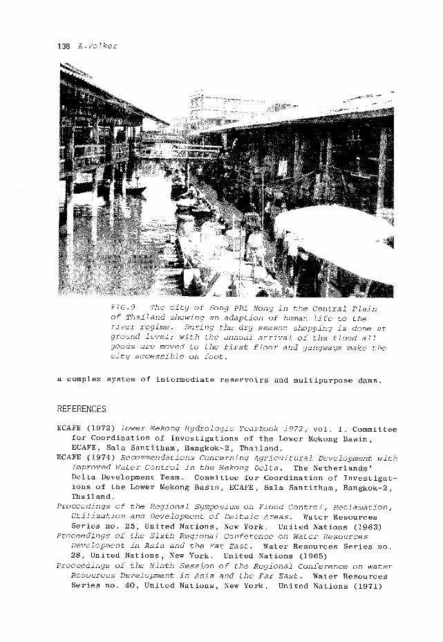
FIG.9 The city of Song Phi Nong in the Central Plain of Thailand showing an adaption of human life to the river regime. During the dry season shopping is done at ground level; with the annual arrival of the flood all goods are moved to the first floor and gangways make the city accessible on foot.
a complex system of intermediate reservoirs and multipurpose dams.
REFERENCES
ECAFE (1972) Lower Mekong Hydrologie Yearbook 1972, vol. I. Committee for Coordination of Investigations of the Lower Mekong Basin, ECAFE, Sala Santitham, Bangkok-2, Thailand.
ECAFE (1974) Recommendations Concerning Agricultural Development with Improved Water Control in the Mekong Delta. The Netherlands' Delta Development Team. Committee for Coordination of Investigations of the Lower Mekong Basin, ECAFE, Sala Santitham, Bangkok-2, Thailand.
Proceedings of the Regional Symposium on Flood Control, Reclamation, Utilization and Development of Deltaic Areas. Water Resources Series no. 25, United Nations, New York. United Nations (1963)
Proceedings of the Sixth Regional Conference on Water Resources Development in Asia and the Far East. Water Resources Series no. 28, United Nations, New York. United Nations (1965)
Proceedings of the Ninth Session of the Regional Conference on Water Resources Development in Asia and the Far East. Water Resources Series no. 40, United Nations, New York. United Nations (1971)