rivers to ridges annual report 2017 - rivers2ridges.org · through a statement of partnership...
TRANSCRIPT

Rivers to Ridges Annual Report 2017

Section 1: Rivers to Ridges Partnership Background and Overview .............................................1 1.1 The Rivers to Ridges Partnership ............................................................................................................................................. 1 1.1.1 Vision Statement ........................................................................................................................................................ 1 1.1.2VisionRefinements ..................................................................................................................................................... 1 1.2 Rivers to Ridges Annual Report ............................................................................................................................................... 2 1.3 Rivers to Ridges Online ............................................................................................................................................................ 2
Section 2: Land Protection ..........................................................................................................3 2.1LandProtectionin2017 .......................................................................................................................................................... 3 2.1.1 Townsend Woods ....................................................................................................................................................... 3 2.1.2WillametteRiverfrontProperty ..................................................................................................................................3 2.1.3 Rob Adams Annex....................................................................................................................................................... 3 2.1.4 Bloomberg Annex ....................................................................................................................................................... 3 2.2SummaryofOverallPartnershipAcreagesintheRiverstoRidgesPlanningArea...................................................................3
Section 3: Habitat Restoration and Management ........................................................................5 3.1 Controlled Ecological Burns ..................................................................................................................................................... 5 3.2NativePlantMaterials ............................................................................................................................................................. 6 3.2.1WestEugeneWetlandPlantMaterialsPartnership....................................................................................................6 3.2.2FriendsofBufordPark&MountPisgahNativePlantNursery ...................................................................................6 3.2.3WillowCreekNursery ................................................................................................................................................. 6 3.3HabitatRestorationandManagement ....................................................................................................................................7 3.3.1EconomicBenefitsoftheWillametteRiverConfluenceProject .................................................................................7 3.1.2WillametteConfluencePlantingEffort .......................................................................................................................7 3.3.3DorrisRanchOakandPrairieRestorationandEnhancement ....................................................................................7 3.3.4CoyoteCreekSouthPhaseI ........................................................................................................................................8 3.3.5StaleyCreekFloodplainRestorationProject ..............................................................................................................8 3.3.6CoyoteSpencerWetland ........................................................................................................................................... 8 3.3.7QuamashPrairieRestorationWorkContinues ...........................................................................................................9 3.3.8OakHabitatRestorationandHazardousFuelsReductionProject ..............................................................................9 3.3.9SmithCreekFishPassageEnhancementProject ........................................................................................................9 3.3.10GreenIslandSwaleConnectionProject....................................................................................................................9 3.3.11PrairieRestorationEffortsContinueatFernRidgeLake ...........................................................................................9
Section 4: Recreation, Education, and Events ............................................................................10 4.1RecreationalImprovements ..................................................................................................................................................10 4.1.1SkinnerButteWestSlopeTrail ..................................................................................................................................10 4.1.2BufordParkTrail5RepairProject .............................................................................................................................10 4.1.3ThurstonHillsTrailandTrailheadParkingCompleted ..............................................................................................10 4.1.4FernRidgeWildlifeAreaInformationKiosks ............................................................................................................10 4.1.5HowardBufordRecreationAreaTrail4RepairProject .............................................................................................10 4.1.6MountainBikeTrailsatThurstonHillsNaturalArea .................................................................................................11 4.1.7InterpretivePanelsatStewartPondDiscGolfCourse ..............................................................................................11 4.2CelebrationsandEvents ........................................................................................................................................................ 11 4.2.1SolarEclipseViewedfromPartnerLandsAcrosstheValley .....................................................................................11 4.2.2DavidB.MarshallHonoredbyUSFWSandPartners ................................................................................................11 4.2.3 Pisgah Heritage Cider Released ................................................................................................................................12 4.2.4WalktheLandDayatGreenIsland...........................................................................................................................12 4.2.5PlayintheRainDay .................................................................................................................................................. 12 4.3Education .............................................................................................................................................................................. 12 4.3.1 Watershed Stewards................................................................................................................................................. 12 4.32MiddleForkVolunteerPlantingCelebration ............................................................................................................13 4.3.3WRENEducationProgram ........................................................................................................................................13 4.3.4LajaRiverWatershedTwinningExchangeProgram ..................................................................................................13 4.3.5CoastForkSciencePub .............................................................................................................................................13 4.3.6DorrisRanchOakSciencePubandTour ...................................................................................................................14 4.3.7StaleyCreekFishSalvage ..........................................................................................................................................14 4.3.8MiddleForkPaddle&Pull ........................................................................................................................................14 4.3.9MRTCommunityToursandVolunteerEvents ..........................................................................................................14 4.3.10RowRiverNatureParkWesternPondTurtleHabitat .............................................................................................15 4.3.11RestorationatBakeStewartParkandDorenaEastWildlifeArea ..........................................................................15
Section 5: Planning and Publications.........................................................................................16 5.1ThurstonHillsNaturalAreaManagementPlan .....................................................................................................................16 5.2WillametteValleyConservationStudy ..................................................................................................................................16 5.3 Long Term on the Long Tom ..................................................................................................................................................17 5.4EugeneParksareSalmon-Safe! .............................................................................................................................................17 5.5OPRDNaturalResourceAssessmentandStrategicActionPlanfortheWillametteBasin ....................................................17 5.6RiverstoRidgesVisionMapUpdated ....................................................................................................................................17 5.7TrustforPublicLandSupportfortheEugeneParksandRecreationSystemPlan .................................................................17
Section 6: Administrative Structure ..........................................................................................18 6.1SummaryofActivities ............................................................................................................................................................ 18
Rivers to RidgesAnnual Report 2017
Cover Photos:LowerCoyoteCreek(JeffKrueger)
SpottedTowhee(CaryKerst)HowardBufordRecreationArea(EdAlverson)
StudentTourofSpencerButteTrail(JeffKrueger)
AnnualReportProducedByTheCityofEugeneand
JeffKruegerEnvironments

Open Space Vision and Action Plan
Willamette River
October 2010
An Open Space Vision for the Willamette River in and around Eugene-Springfield, Oregon
R2R Partnership Organizations•CityofEugene
•CoastForkWillametteWatershedCouncil•FriendsofBufordPark&MountPisgah•LaneCountyPublicWorksDepartment
• Long Tom Watershed Council•McKenzieRiverTrust
•McKenzieWatershedCouncil•MiddleForkWillametteWatershedCouncil•OregonDepartmentofFish&Wildlife
•OregonParksandRecreationDepartment•TheNatureConservancy•TheTrustforPublicLand
•U.S.ArmyCorpsofEngineers•U.S.BureauofLandManagement
•U.S.Fish&WildlifeService•WillamalaneParkandRecreationDistrict
•WillametteResourcesandEducationalNetwork
1 Rivers to Ridges Partnership Background and Overview
page 1
1.1 The Rivers to Ridges Partnership
The Rivers to Ridges Partnershipisavoluntaryassociationofseventeenorganizationsworkingcollaborativelytoadvancetheprotection,restoration,management,andpublicuseofopenspaceresourcesinthesouthernWillametteValley.ThenameRiverstoRidges(R2R)emanatesfromaregionalopenspacevisiondocumentwhichwasendorsedbymanyorgani-zationsandunanimouslybylocalelectedofficialsfromtheEugene-Springfieldareain2003.
1.1.1 Vision Statement
ThevisionfortheRiverstoRidgesPartnership,asdefinedintheR2RStatementofPartnershipis:
To improve the quality of life of residents in the upper Willamette Valley by working together to protect and enhance the region’s land and water resources and their ecosystem functions and values, and to provide environmental educa-tion and compatible outdoor recreation opportunities as outlined in the Rivers to Ridges Metropolitan Regional Parks and Open Space Study - Vision and Strategies document (2003).
1.1.2 Vision Refinements
The2003visionwasfurtherrefinedbyR2RpartnersinsubsequentyearsandincludestheRidgeline Vision and Action Plan (2008)andtheWillamette River Vision and Action Plan (2010).TheRiverstoRidgespartnershipwasformalizedin2010throughaStatementofPartnership(SOP),signedbyallpartnerorganizations.TheSOPoutlinestheadministrativestruc-tureofthepartnershipandemphasizesthecommitmenttoworkcollaborativelytowardimplementationofthevision.
The R2R Partnership mission is to advance implementation of the vision outlined in the Rivers to Ridges Metropolitan Regional Parks and Open Space Study – Vision and Strategies document.
Ridgeline Area
February 2008
Open Space Vision and Action Plan
Rivers to RidgesMetropolitan Regional Parks and Open Space Study
Vision and Strategies
June 2003
WelcomeMcKenzie Watershed Council!With the unanimous vote of the R2R Executive Team, the McKenzie Watershed Council (MWC)
was formally added to the Rivers to Ridges Partnership in December. Although new to the
R2R Partnership, the MWC has been active in our area since 1993, working with private landowners to conserve and restore riparian and aquatic habitat, monitor and maintain
water quality, and provide a monthly forum for addressing important issues.

page 2
1.2 Rivers to Ridges Annual Report
ThisisthefifthAnnualReportpro-ducedbythepartnership.Thepur-poseofthereportistodocumentkeydecisionsandactivitiesfortheyearandtoprovideanoverviewofadministrativestructureoftheR2R partnership. The annual report provides the partners with an op-portunitytohighlighttheirownachievementsfromtheyearthathavesupportedtheimplementationofthesharedR2Rvision.
1.3 Rivers to Ridges Online
The R2R Partnership maintains a web site at www.rivers2ridges.orgwherevisiondocuments,maps,annualreports,andinformationaboutR2RPartnershiporganizationscanbeaccessed.
4,235acres
2017 by the Numbers
15,000Loads
6,241acres
Total acres treated through controlled ecological burns on R2R Partner lands since 1986
Acres of additional land protected by R2R Partners since 2003
The equivalent number of semi-truck loads of sand, gravel, and dirt moved during the Willamette Confluence Project
Rivers to Ridges Annual Report 2013 Rivers to Ridges Annual Report 2014
Click to Open Recent Annual Reports
Rivers to Ridges Annual Report 2015
Trail camera photos of an elk herd and a mountain lion captured at the Thurston
Hills Natural Area in 2017
Photo credit: Willamalane Photo credit: Willamalane

page 3
2 Land Protection
2.1 Land Protection in 2017
In2017,theCityofEugene and WillamalaneParkandRecreationDistrictconservedanadditional51acresofland,allthroughfeetitleacquisition.ThisbringsthetotalpartnerlandbasewithintheR2Rplanningareatoanestimated23,968acres.The2017acquisitionsandeasementsarelistedbelowandshownontheRiverstoRidgesmaponpage4.
2.1.1 Townsend Woods
The CityofEugeneacceptedadonationof33.9acresintheareajusttothewestofGreenhillRoad.Thislocationisiden-tifiedintheEugeneTrailsPlanasbeingattheintersectionoftwodesiredtrailcorridors.Thelandownerhadinitiallycontacted McKenzieRiverTrust andTheNatureConservancy aboutadonation,andduetothelocationandsiteconditions,theownerwasreferredtotheCity.ThisisgreatexampleoftheR2RPartnersworkingtogether.
2.1.2 Willamette Riverfront Property
The CityofEugenepurchaseda7-acrepropertywithover1,000feetoffrontagealongthewestbankoftheWillametteRiverin2017.Thesite,whichislocatedjusttothenorthofSantaClaraPark,hasyettobenamed.TheCityplanstousethe site to accommodate improved public access to the river andwillenhanceecologicalfunctionsovertime.
2.1.3 Rob Adams Annex
Willamalanecompletedacquisitionofa5-acrewetashwoodlandintheareaimmediatelyadjacenttoRobAdamsPark.Thesitewillberestoredovertimetosupportnativeplantspecies.
2.1.4 Bloomberg Annex
The CityofEugenecompletedthepurchaseofa4.4-acreadditiontotheRidgelineParksystemintheareajusttothesouthofBloombergPark.Theforestedsitewillprovideoptionsforfuturetrailconnectionsinthearea.
2.2 Summary of Overall Partnership Acreages in the Rivers to Ridges Planning Area
RiverstoRidgespartnerscurrentlyownorholdconservationeasementsonanestimated23,968acresoflandwithintheR2Rplanningarea(seetable)includingtheadditional51acresaddedin2017.SincetheRiverstoRidgesvisionwasen-dorsedin2003,theR2Rpartnershavecombinedtopreserveapproximately6,241acresofland,increasingtheconservedlandbasebynearlythirtypercentinjustoveradecade.
Newly acquired riverfront property
Photo credit: McKenzie River Trust
R2R Partner Ownership and Easements AcresBureauofLandManagement(WEW)* 1,305BureauofLandManagementEasement 22U.S.ArmyCorpsofEngineers 3,870CityofEugene 4,531FriendsofBufordPark&MountPisgah 63LaneCounty 3,969McKenzieRiverTrust 1,600McKenzieRiverTrustEasements 1,131OregonDepartmentofFish&Wildlife 607OregonParksandRecreationDepartment** 1,943TheNatureConservancy 3,028WillamalaneParkandRecreationDistrict 1,622
Total: 23,968
* BLM owns and manages another 27,409 acres of land within the Rivers to Ridges planning area, mainly O&C land within the Coburg and Thurston Hills.
** Includes 120 acres of Oregon Department of State Land ownership.
R2R Partner Conserved Lands
Photo credit: City of Eugene

Rivers to Ridges Vision Map with Accomplishments and 2017 Acquisitions
ThemapaboveisacompilationoftheRiverstoRidgesvisionmapthatwasendorsedbylocalelectedofficialsin2003andanoverlayofmajoropenspaceacquisitionsthathaveoccurredsincethattime.2017acquisitionsareshowninred.
page 4
MWMC
Seavey Loop Rd.
Lowell
COYOTE-SPENCER
WETLANDS
COYOTECREEK
MEADOWS
COYOTE CREEK NE
COYOTEPRAIRIE
COYOTECREEK
SPENCERSWAMP
ANDREWREASONERWILDLIFEPRESERVE
GOLDENGARDENS
LOMATIUM PRAIRIE
COYOTEOAKS
COYOTESWAMP
DECKER
GREEN ISLAND
No Public Access
(MRT)
SOUTH EUGENE
MEADOWSSUZANNE
ARLIE PARK
CORYELLRIDGE
TURTLEFLATS
WILLAMETTE CONFLUENCE
PRESERVE(TNC)
No Public AccessNo Public
Access
COBURGRIDGE
PRESERVE
No Public Access
CHUBSLOUGH
BERGGREN
MCKENZIEOXBOW
ROBADAMS
PARK
THURSTONHILLS
HAULROAD
CRESWELLBUTTE
No Public Access
No Public Access
Agricultureand Floodplain
HOLLYERPRAIRIE
No Public Access
No Public Access
No Public Access
HENDRICKSBRIDGE
Camas SwalePrairie and
Savanna
Poten�al FutureRails to Trails
Connec�on to Coos Bay
AgriculturalLands
PlannedCoburg
Loop
Agricultureand Floodplain
Agricultureand Floodplain
Agriculture and Floodplain
CanalBirding
Trail
Proposed Eugeneto Pacific Crest Trail
Proposed Eugeneto Pacific Crest Trail
Proposed Pathto Veneta(ODOT)
SPENCER BUTTE
AMAZONPARK
LAURELWOODGOLF COURSE
HENDRICKSPARK
WILLOW CREEKNATURAL AREA
(TNC)
ARMITAGEPARK
BETHELCOMMUNITY
PARK
SANTA CLARA PARK
BAKER
River
River
Amazon
Creek
McKenzie
SKINNERBUTTEPARK
WESTMORELANDPARK
AMAZONHEADWATERS
Beltl
ine
Highway 126
River Rd.
Highway 99
Irving Rd.
Irvington Rd.
11th Ave.
Royal Ave.
Barger Dr.
18th Ave.
Bert
else
n Rd
.
Gree
n Hi
ll Rd
.
Road
6th Ave.
7th Ave.
Highway 99
30th Ave.
Coburg Rd.
Beltline
Road
Cal Young Rd.
Delta
Northwest Expy
Cham
bers
St.
105/126
Franklin Blvd.
ASCOTPARK
I-5
I-5
DELTAPONDSPARK
Highway 58
I-5
ALTON
PARK
Fern
RidgeReservoir
Middle
Fork
Coast
Fork
BUFORDRECREATION
AREA
Main StreetHighway 126
Pioneer Parkway
DORRISRANCH
Gate
way
Str
eet
HILEMAN
FERNRIDGE
WILDLIFEAREA
Amazon
Creek
Will
ame�
e St
.
FoxHollow
Road
Baile
yHi
llRo
ad
Hill
Road
Gimpl
DRAGONFLYBEND
BERTELSENNATURE
PARK
LUK-WAHPRAIRIE
OAK HILL
MURRAYHILL
VIDERA
SKYVIEW
MELVINMILLER
HAWKINSHEIGHTS
WAYNE MORSEFAMILY FARM
CRESTHEIGHTS
LAFFERTY
BLANTONRIDGE
MOUNTBALDY
TUGMAN
KINCAID
BLOOMBERG
MOONMOUNTAIN
LAURELHILL
WASHINGTON
EASTGATEWOODLANDSMONROE
MAURIEJACOBS
PARKBLOCKS
RASOR
WALNUTGROVE
PETERSON
WENDOVERAWBREY
TERRALINDA
CREEKSIDE
STRIKERFIELD
WILLAKENZIE
OAKMONT
GILLESPIEBUTTE
SORRELPOND
BONDLANE
ARROWHEAD
FERNDALE
LONEOAK
WESTBANK
OWENROSE
GARDEN
EMERALD PARK
(RRPRD)
Dillard
Road
Willam
ette
QUAMASH PRAIRIE
ShortMountain
Landfill
MEADOWLARKPRAIRIE
MWMCBiocycle
Farm
Airport
DexterReservoir
ELIJAHBRISTOW
STATE PARK
DEXTERSTATE PARK
JASPERSRS
BOBKEEFERCENTER
HARVESTLANDING
WEST D GREENWAY
LOGJAMLANDING
KELLYBUTTE
BEACONLANDING
WHITELYLANDING
BIGISLAND
MWMC
LCC
LCC
CLEARWATER
LIVELY
RUFF
BOBARTZ
WILLAMALANE
Creek
Coyote
No Public Access
VICKERY
Mohawk
River
McKenzie
View
Drive
Camp Creek Road
Mohaw
k
32nd
St.
Centennial
42nd
St.
Straub
Jasper
Road
Park
way
Roa
d
ORCHARDPOINT
PERKINS PENINSULA
ZUMWALT
RICHARDSON
Terri
toria
l High
way
Clear Lake Road
Spencer
Creek
Long
Tom
Rive
r
LongTom River
Amazon
Diversion
Willamette
Millrace
Millrace
WILLAMETTEDAISY MEADOW
Road
Crow
Creek
Camas Swale
WildHog Creek
Russ
elCr
eek
Creek
Papenfus
Cree
k
Rattlesnake Creek
Lost
Creek
Fall
CreekHills
Veneta
Crow
Creswell
Spring�eld
Eugene
PleasantHill
Goshen
Mohawk
Walterville
Dexter
Alvadore
CreekCedar
Will
owCr
eek
JunctionCity
Coyote
Creek
FERNRIDGE
WILDLIFEAREA
ShortMountain
Camas SwaleFloodplain
Hwy.
OXBOW
MOEMOUNTAIN
Future Community
Park
Coburg
WaltervilleCanal
KirkPond
SEE-SIL SAVANNA
FIRBUTTE
QUARTZ
Bob Pkw
y.
TYSON
WYERHAEUSERMcKENZIE
PATH
ALLEN
FERN RIDGE
WILDLIFE AREA
FERNRIDGE
WILDLIFEAREA
Upper SpencerCreek Grassland and Oak/Prime Woodland
Long-TermReclama�on Opportuni�es
Rivers to Ridges
* Map Update: This vision map was revised in 2017 to include updated extent of conserved lands, trails, and paths along with a more detailed geographic base. The parks and open space vision shown is consistent with the concepts depicted on the original 2003 Rivers to Ridges vision map and subsequent refinements including the 2008 Ridgeline Area Open Space Vision and the 2010 Willamette River Open Space Vision. The Rivers to Ridge vision was endorsed by the Lane County Board of Commissioners (February 2003), The Eugene City Council (March 2003), the Willamalane Park and Recrea�on District Board (April 2003), and the Springfield City Council (May 2003), all by unanimous consent. The vision is intended to provide a framework for future open space planning efforts.
June 2003 Vision (Updated December 2017*)
Metropolitan Regional Parks and Open Space Vision Map
Legend Parks, Open Space, and Conserved Lands (Public)Other Conserved Lands (Land Trusts and Non-Profits)*Rivers and StreamsReservoirs (full pool)Exis�ng So�-Surfaced Recrea�onal TrailsExis�ng Hard-Surfaced Path
Scale
0 2 Miles1 Map produced by Jeff Krueger and the
R2R Partnership
Rivers to Ridges Vision ElementsKey Open Space Anchors (Exis�ng and Possible Future)Key Upland Corridors (Ridges)Key Water Based Corridors (Rivers and Streams)Key Agricultural Areas and Community BuffersProposed Future Regional Trails and Paths (Conceptual)Community Gateways
Vision with 2017 Conserved Lands
* Public access is typically not provided to these areas.
Major Accomplishments Since 2003Major Open Space Land Acquisi�ons and Conserva�on Easements
2017 Acquisi�ons and Easements
New Paths and Trail Segments
TOWNSENDWOODS
RIVER
BLOOMBERGANNEX
ROB ADAMSADDITION

page 5
3 Habitat Restoration and Management
0
100
200
300
400
500
60019
8619
8719
8819
8919
9019
9119
9219
9319
9419
9519
9619
9719
9819
9920
0020
0120
0220
0320
0420
0520
0620
0720
0820
0920
1020
1120
1220
1320
1420
1520
1620
17
Acres
Yearly Acreage Burned by Rivers to Ridges Partners (acres)
2017 Coyote Prairie burn underway
3.1 Controlled Ecological Burns
TheR2RPartnershipcompletedninecontrolledecologicalburnstotaling306acresin2017onU.S.BureauofLandMan-agement,TheNatureConservancy,CityofEugene,andU.S.ArmyCorpsofEngineers(ACOE)administeredlands.Over900acreswereplannedforthissummerandfall,however,acreageremainedbelowthe348acrefive-yearaverageduetosmokeimpactsfromwildfiresacrossthePacificNorthwest,aswellasfiredangerlevelsremainingelevatedthroughthemonthofSeptemberwhenburningtypicallyoccurs.
AsummerburnwassuccessfullyconductedatTNC’sWillametteConfluencePreserveinuplandprairieandriparianareasinpreparationforseedingwithnativespecies.Aspartofacomprehensiverestorationplan,controlledburningwasimple-
mentedsafelywithunitssurroundedbylargeareasofbareearthcreatedthroughexcavationofformergravelpitsintheprocessofbeingreconnectedtotheriverfloodplain.
TheCenterforNaturalLandsManagementandJointBaseLewis-McChordpartneredwithTNCtocon-ductcontrolledecologicalburnsintheRiverstoRidgesPartnershipandthroughouttheWillametteVal-leyunderacooperativefiremanagementagreementforthefirsttimethisyear.BothentitiesconductburnsthroughoutthesummerinPugetSound’sprairiesforhabitatrestorationandconservationofrareand endangered species.
DroneswereusedtofilmburningatCoyotePrairie(photoleft),ownedandmanagedbytheCityofEugene,providingabird’seyeviewoftheuseoffireforhabitatmanagement.ThefirstentryoffireinrecenthistoryattheACOE’sEastWildlifeAreaonthenortheastshoreofDorenaLakewasalsocon-ductedtomaintainprairiehabitatstructure.BurningformaintenanceoffederallylistedFender’sbluebutterflyanditshostplantKincaid’slupine,wasalsocompletedin2017bytheBLMandpartnersnearFirButte.
Drone photos provided a unique perspective of the 2017 burn at Coyote Prairie
Photo credit: AJ Hudgik (ODF)

page 6
Clarikia amonia in production bed at Heritage Seedlings
3.2 Native Plant Materials
3.2.1 West Eugene Wetland Plant Materials Partnership
The U.S.BureauofLandManagement,CityofEugene,andTheNatureConservancy’splantmaterialspartnershipcontinuestoproducelocally-sourcednativeseedandplantsforrestorationandenhance-menteffortswithintheWestEugeneWetlandsandassociateduplandprairies.Inadditiontomorecom-monnativeannualsandperennials,theprogramisprovidingseedofslow-growingprairiespecies,suchascommoncamasandnarrow-leafmule’sear,thattakefiveormoreyearstoreachreproductivesizeandthusrequirealong-termproductioncommitment.ThePartnership’s0.1-acreCamasbeds,forex-ample,arenowproducingbetween40and75poundsofseedannually.
Forthe2017harvestyear,thePartnershiplostoneofitsthreevaluedproducers,thefederalCorval-lisPlantMaterialsCenter(PMC).ThePMCwasunabletocontinuetopropagate22nativespeciesforthePartnership,primarilyannualandvernalpoolspeciesthatarenototherwiseavailable.In2017,thepartnershipwasabletocontinuetosupplynativeseedofover70speciesforuseinlocalrestorationandenhancementprojects,byrelyingoninventoryforthosespeciespreviouslygrownbyPMC.ThePartnersareexploringoptionsforreplacingthePMCspecies.
AlthoughalmostallofthenativeseedusedinthepartnershipisproducedbyWillametteValleygrowers,thepartnershipcontinuestorelyonhandcollectionfromwildsitesforafew,locallycommonwetlandspeciesandtoaddgeneticdiversitytocultivatedspecies.Seasonalbotanistsandinternsworkingforthepartnershiphandcollectedseedof27nativespeciesin2017andsubmittedseedfromseveralofthese
collectionstothenationalSeedsofSuccessprogram,whichpartiallyfundsthenativeplantmaterialsprogramthroughtheBLM.Altogether,about850poundsoflocalnativeseedwasproducedandprocuredfortheplantmaterialsprogramin2017,withover700additionalpoundsusedfromseedinventory.Theprogramsuccessfullyprovidedseedforabout265acresofrestorationprojectsinover20locations.Inaddition,theprogramagainprovided72seedmixesforanongoingresearchprojectaddressingrecoveryofFender’sbluebutterflyandprairierestoration.
3.2.2 Friends of Buford Park & Mt. Pisgah Native Plant Nursery
The FriendsofBufordPark&MountPisgah(Friends)managesanativeplantmaterialsprogramwithatwo-acrenurseryfacilityatitscore.Thenursery,locatedinLaneCounty’sBufordPark,propagatesplantmaterialsforuseinhabitatprojectsinthegreaterMountPisgaharea.ThenurseryalsoprovidessurplusseedandplantstootherrestorationentitiesforhabitatprojectselsewhereintheWillametteValley.Staffandsupervisedvolunteerscollectcuttings,divisions,andseedsfromdiversenativeplantpopulationsfoundatMountPisgah,andthenpropagatetheminthenursery.Thenurseryproducedplantmaterialsfrom150nativespecies,includinggrasses,wildflowers,shrubs,andtrees.MuchofthismaterialisbeingutilizedforthenearbyConfluenceFloodplainRestorationProject.
3.2.3 Willow Creek Nursery
TheNatureConservancy’sWillowCreekNurserycontinuestoproducesmallquantitiesofBradshaw’slomatium,Willamettedaisy,andKincaid’slupineseedforuseinlocalrestorationprojects,mostlyattheWillowCreekPreserve.
Friends Nursery Native Plant Open House

page 7
Photo credit: Jeff Krueger
3.3 Habitat Restoration and Management
ListedbelowisasamplingofmajorhabitatrestorationandmanagementprojectsimplementedbyR2Rpartnersin2017.
3.3.1 Economic Benefits of the Willamette Confluence Restoration Project
Aftersevenyearsandmovingenoughsand,gravel,anddirttofill15,000semi-trucks,sixmilesoftheWil-lametteRiverhavebeenreconnectedtohistoricfloodplainhabitat.Notonlyisthisprojectresultinginma-jorhabitatimprovements,it’salsopayingdividendstothelocaleconomy.
“Onthenationallevel,it’sreportedthat$2.2to$3.4millionintotaleconomicoutputand13to32jobsarecreatedforevery$1millioninvestedinecosystemrestoration,”saidBCIContractingOwnerDanPorter.“InOregon,it’sestimatedthat24jobsarecreatedper$1,000,000invested,and80percentofthemoneyspentonrestorationprojectsstayswithinthecountywheretheprojectislocated.”Throughlocalsupport,private,Stateandfederalgrants,nearly$7millionwillhavebeeninvestedinthisprojectduringthelastdecade.Thatequatesto168jobsand$5.6millioninvestedinLaneCounty.ThisisthelargestfloodplainrestorationprojectevertotakeplaceontheWillametteRiver,andthebenefitsitprovidestopeopleandnatureareseeminglyendless.Thistypeofhabitatconnectionontherivernotonlyprovidesaboosttothelocaleconomy,itcleansdrinkingwater,aidsinfloodcontrol,createsmorerecreationopportunitiesandprovidescriticalhabitatforfishspecies,includingthethreatenedChinooksalmon.“Inthecomingyear,
we’llenterthefinalphaseofthisprojectandplantmoretrees,shrubsandplants,”saidTheNatureConservancy’sWil-lametteRestorationManagerJasonNuckols.“We’relookingforwardtosharinglessonslearnedtoscalethisprojectwithinandbeyondOregon.”
3.3.2 Willamette Confluence Planting Effort
Afteryearsofplanningandinter-agencycollaboration,extensivesitepreparation,thenexcavating15channelsegmentstoconnect10historicgravelpondstotheWillamette,theFriendsofBufordPark&MountPisgah have completed a massive plantingefforttorestorefivedifferenthabitattypesonover60acresonthreeownerships.TheplantingprojectimproveddiversehabitatsonlandsownedbytheFriendsofBufordPark&MountPisgah(TurtleFlats),TheNatureConservancy(Wil-lametteConfluencePreserve),andtheOregonParksandRecreationDepartment(GlassBarAccess).TheplantingeffortcommencedinFall2016aftertherainsreturned,andcontinueduntilApril2017.
Friends’stewardshipstaffledvolunteersandvariedcontractcrews,whichincludedhelpfromOregonWoods,NorthwestYouthCorps,andWalamaRestoration.Inall,crewsplantedover62,000treesandshrubsandover31,000“plugs”ofgrass-esandwildflowers,andbroadcastover850poundsofnativeseed.Over113differentspeciestobenefitadiversityoffishandwildlifespecieshavebeenused.
3.3.3 Dorris Ranch Oak and Prairie Restoration and Enhancement
The MiddleForkWillametteWatershedCouncil and WillamalaneParkandRecreationDistrict partnered to restore 15 acres ofoakwoodlandand33acresofprairiehabitatatDorrisRanchinSpringfield.Historically,thiswoodlandwasdominatedbyOregonwhiteoak,butoverthepastcentury,Douglas-fir,bigleafmaple,Oregonash,andcherryhavetakenover.ThesetreeswereoutcompetingtheoaksforsunlightandotherimportantresourcesandreducingkeyhabitatforspeciesthatdependonoakssuchastheacornwoodpeckerandWesterngraysquirrel.Toremedythisproblem,theprojectfocusedon“releasing”theoaktreesbythinningthemajorityofthenon-desirabletrees.TheresultisamoreopenwoodlandthatwillallowtheOregonwhiteoaktothrive.Additionally,contractorshavebeenremovinginvasivespeciesfromtheprairiethroughout2016and2017.FundingforthisprojectcamefromtheOregonWatershedEnhancementBoardandWillama-lane.
Confluence Restoration Project area looking west (down river) with the 2017 levee removal
area shown on the left side of the photo.
Results of the 2016 planting effort at Turtle Flats
Photo credit: Friends

page 8
3.3.4 Coyote Creek South Phase I
Constructionandplantingatthe116-acrefirstphaseofCoyoteCreekSouthwascom-pletedthroughcollaborativepartnershipbetweentheLong Tom Watershed Council and OregonDepartmentofFishandWildlifewithadditionalassistanceprovidedbytheCityofEugene,U.S.Fish&WildlifeService,BonnevillePowerAdministration,andtheAmericanBirdConservancy.Withthegoalofrestoringnativewetprairiehabitats,thesiteispartoftheFernRidgeWildlifeArea(FRWA)andadjacenttotheCityofEugene’sCoyotePrai-riesite.ThroughanOregonWatershedEnhancementBoardgrant,theLTWCwasabletoprovidefundstoassistwithplanning,pre-projectmonitoring,planting,andpurchasingofseedfromsixtyspeciesofwetprairieplants.Therestorationprocessconsistedoftwoyearsofsitepreparationtoremovethenon-nativeseedbankthroughmowingandselec-tiveherbicidetreatments,followedbythecreationofshallowvernalpoolsandaseriesofbermstoretainwateronthesite.StafffromtheODFWHabitatProgramutilizedUSFWSequipmenttoperformtheearthwork.Overthecourseoffiveweeks,ODFWconstructedeighteen berms and seven vernal pools.
3.3.5 Staley Creek Floodplain Restoration Project
StaleyCreek,atributaryoftheUpperMiddleForkWillametteRiver,washistoricallystraightened,channelizedandbermed,resultinginadegradedstreamdisconnectedfromitsfloodplain.Toremedythat,inJulyandAugust2017,theMiddleForkWillamette
Watershed CouncilandtheU.S.ForestService(USFS)MiddleForkRangerDistrictimplementedalarge-scalefloodplainrestorationproject.Projectimplementationincludedpushingoverwholetreeswithrootwadsinuplandforeststocreategapsandtransportingthemtotherestorationsite;removinginvasivevegetationintheprojectarea;movingnearly50,000cubicyardsofmaterialtoremovebermsandraiseincisedchannels;andplacingapproximately600piecesoflargewoodacrossthefloodplain.Thefinalproductis46acresoffloodplainreconnectedoveronestreammile.ThiswasthelargestprojectthattheMFWWChasevertakenonanditcouldnothavehappenedwithoutourpartnershipwiththeUSFS,assis-tancefromOregonDepartmentofFishandWildlife,andtheexcellentcontractingservicesprovidedbyHaleyConstructionCompany.Weexpectthisnew,dynamiclandscapetodampenfloodevents,raisethewatertableandincreasefloodwaterstorage.Byrestoringthesehydrologicprocesses,habitatconditionswillimproveand,inturn,willbenefitfishandwildlife.FundingforthisprojectcamefromtheOregonWatershedEnhancementBoard,theUSFS,andtheWesternNativeTroutInitiative.
3.3.6 Coyote Spencer Wetland
In2017,theMcKenzieRiverTrustpartneredwiththeInstituteforAppliedEcology(IAE)toplant9,180nativeripariantrees,shrubs,andprairieplantsonthe190-acreCoyoteSpencerWetlandproperty.Workcontinueswithmowingandspraying30acresofprairiehabitat.MRTandIAEalsofinishedatwo-yearplotstudyresearchinglivestockgrazingeffectsonBradshaw’slomatiumaspartofanOWEB,Bradshaw’slomatiumHabitatManagementproject.Theproject’sgoalsaretostudyanddevelopgrazingtechniquesthatwillbenefitwetlandhabitatsandpositivelyimpactBradshaw’slomatiumpopulationsintheWillametteValley.
3.3.7 Quamash Prairie Restoration Work Continues
LaneCountyWasteManagementcontinuestoimplementwetlandrestorationactivitiesatQuamashPrairienearShortMountain.Restorationbeganin2003witha28-acrewetlanden-hancementthatmitigatedforwetlandlossassociatedwithexpansionoftheShortMountainLandfill.Currently86acresofwetlandsarebeingmanagedatthesitewiththehelpoflocalhighschools.Since2009,approximately600studentvisitseachyearhavecontributedtowet-land habitat improvements.
Coyote Creek South Phase (looking south)
Berm removal and large wood placement underway at Staley Creek in 2017
Photo credit: Tim Giraudier

page 9
3.3.8 Oak Habitat Restoration and Hazardous Fuels Reduction Project
Throughfundingpro-vided through the U.S.BureauofLandMan-agement’sCommunityAssistance Fund and additionalfundingre-ceived in partnership with the Long Tom Watershed Council,the CityofEugene completedprojectsmeetingmultiplegoalsincluding habitat resto-ration(oakandmixedwoodland)andhazard-ousfuelsreduction.Through these partner-ships,projectswereimplementedonSkinnerButte,SuzanneArlie,WildIrisRidge,andSouthEugeneMeadowsin2017.
3.3.9 Smith Creek Fish Passage Enhancement Project
Twounder-designedandunder-sizedculvertswerereplacedwithbridgesalongSmithCreek,atributarytotheCoastForkWillametteRiver.Aftercompletion,largewoodwasplacedinthecreektoimproveandrestorenativefishhabitat.TheprojectwascompletedinSeptember2017andopened3.5milesoffishspawninghabitat.ProjectpartnersincludeCoast
ForkWillametteWatershedCouncil,U.S.BureauofLandManagement,OregonDepartmentofFishandWild-life,andWeyerhaeuserCompany.
3.3.10 Green Island Swale Connection Project
The McKenzieRiverTrustcompletedanotherfloodplainenhancementprojectatGreenIslandin2017,withtheconnectionofafloodplainswaletoasidechanneloftheWillametteRiver.Theprojectincludedthere-movalofrevetmentstoconnectwhathadbeenanisolatedman-madefishingpondintothesidechannel.Beyondthepondisaswalethatwillnow,onaverage,beinundated14daysoftheyearnowthattherevet-menthasbeenremoved.Inall,350feetofleveeand12,200yardsofmaterialwasremoved,and47acresoffrequentlyinundatedswalesplantedintoriparianforest.ThisprojectwasmadepossiblebyanOWEBSpecialInvestmentProgramgrantawardwhichwasfundedbyOWEB,BonnevillePowerAdministration(BPA),andtheMeyerMemorialTrust.
3.3.11 Prairie Restoration Efforts Continue at Fern Ridge Lake
The U.S.ArmyCorpsofEngineerscompletedthetwentiethyearofprairierestoration,host,andnectarplantaugmentationintheFernRidgeLakeareatoimprovehabitatconditionsfortheFender’sbluebutterfly.Pre-scribedfireonportionsof3unitswithNorthwestOregonDistrictBLMfireshopwascompletedin2017,fol-lowedbyseedingandtransplantingwithstaffandLaneMetroYouthCorps.Butterflycountsareamongthehighestsincemonitoringbegan.TheCorpsalsoburned50acresofBradshaw’slomatiumandWillamettedaisyhabitatintheFisherButteunitoftheFernRidgeNaturalArea.UnburnedareawillserveascontrolsinanongoingdemographicstudyofthelargestremnantWillamettedaisypopulation.
Large wood placement on Smith Creek
Photo credit: CFWWC
Fuels reduction project a Skinner Butte Park

4 Recreation, Education, and Events
page 10
Photo credit: Willamalane
4.1 Recreational Improvements
4.1.1 Skinner Butte West Slope Trail
ToimproveaccessandsafetyintheareaaboveclimbingcolumnsonthewestsideofSkinnerButte,theCityofEugene con-structedanewquarter-miletrail.Thistrailincludesapproximately45woodensteps,gravelsurfacing,andcablehandrails.Thetrailwillprovideasingle,well-definedroutetothesummit,replacingmultipleusertrailsthathadformedovertime.Usersoftheseunauthorizedtrailswereunintentionallycausinghabitatimpactsandoftendislodgedrocksabovethispopu-larrock-climbingarea,causingsafetyconcerns.SinceitsopeninginDecember,thenewtrailhasbecomeapopularroutetothe summit.
4.1.2 Buford Park Trail 5 Repair Project
FriendsofBufordPark&MountPisgahstaffandVolunteerscollaboratedwithLaneCountyPublicWorksstafftorepairandexistingone-milesegmentoftrail5inBufordPark.Theimprovedtrailpro-videsyear-roundaccessandconnectivityfortrailusersandparkstaffalike.
4.1.3 Thurston Hills Trail and Trailhead Parking Completed
A new Willamalanetrailheadanda50-vehicleparkinglot,locatedalongMcKenzieHighway(Hwy.126),wasdesignedandconstructedinthesummerof2017toserveasthemaintrailheadfortheThurstonHillsNaturalArea.ThetrailheadservestheNorthAccessTrail,whichwilleventuallypro-videaccesstoanextensivenetworkofsoftsurfacetrailsopentohikersandmountainbikers.Inad-dition,approximatelythreemilesofnewtrailwereconstructedtoprovidethepublicwithaccesstothis natural area.
4.1.4 Fern Ridge Wildlife Area Information Kiosks
Threeinformationalkioskscompletewithnewinterpretivesignagewereconstructedbythe“FriendsofFernRidgeWildlifeAreaTuesdayVolun-teerCrew”attheCantrell,Fisher
Butte,andRoyalParkingLotswithassistancefromOregon DepartmentofFishandWildlife.Materialsfortheprojectwerepurchasedwithfundsreceivedfromwildlifeareaparkingpermits.
4.1.5 Wild Iris Ridge Trail Grand Opening
OnOctober24th,theCityofEugene held a grand opening oftheWildIrisRidgeSharedUsetrail.The1.3-milesectionprovideswonderfulviewsoftheWestEugeneWetlandsandmuchoftheRidgeline.ThisisnowthewesternmostsectionoftheRidgelineTrail.
Skinner Butte West Slope Trail
Photo credit: City of Eugene

page 11
4.1.6 Mountain Bike Trails at Thurston Hills Natural Area
OurlocalMountainBikeClub,theDisciplesofDirt,haspartneredwithWillamalaneParksandRecreationDis-trict toconstructanetworkofmountainbiketrailsintheThurstonHillsNaturalArea.Twowell-attendedworkpartieswereheldinthefallof2017whereapproximatelytwomilesoftrailwereconstructed.Additionalworkisplannedfor2018.
4.1.7 Interpretive Panels at Stewart Pond Disc Golf Course
WillametteResources&EducationalNetwork partnered with the CityofEugene,U.S.BureauofLandManagement,andtheEugeneDiscGolfClubaspartofthecreationofadiscgolfcourse,whichwascompletedin2015.WRENhadthespecifictaskofhelpingtocreateinterpretivepanelsateachholethathighlightthenaturalhistoryofwetlandecosystemsatStewartPonds.Thepanelsweredesignedandcompletedin2017andarecurrentlyintheprocessofbeinginstalledat Stewart Ponds.
4.2 Celebrations and Events
4.2.1 Solar Eclipse Viewed from Partner Lands Across the Valley
NoannualreportwouldbecompletewithoutmentioningtheamazingnaturalphenomenonthattrackedacrosstheWillametteValleyonAugust17,2017.Thetotalsolareclipsewasenjoyedbycloseto7,000visitorsacrosstheU.S.FishandWildlifeServiceRefugesintheWillametteValley!We’restillinawe.
4.2.2 David B. Marshall Honored by USFWS and Partners
OnSaturday,September23rd,theU.S.FishandWildlifeService honored David B.Marshallwhowasinstrumentalines-tablishingtheWillametteValleyRefuges.TogetherwiththeFriendsoftheWil-lametteValleyNationalWildlifeRefugeComplex,SalemAudubonSocietyandAudubonSocietyofPortland,theUSFWSdedicatedtheDavidB.MarshallStudySiteandfutureOutdoorClassroomatPeregrineMarshinhishonor.Hewasanamazingmanandleftanincrediblecon-servationlegacy.Thatsameday,AnkenyNationalWildlifeRefugehostedanOpenHousewithpartnersandvolunteersof-feringactivitiesatallofthefavoritepull-outsandoverlooks.
Northern Flicker
Northern Flickers are large, brown woodpeckers with black-scalloped plumage. Although it can climb up the trunks of trees and hammer on wood like other woodpeckers, the Northern Flicker prefers to find food on the ground. Flickers eat mainly ants and beetles, digging for them with their unusual, slightly curved bill. Flickers can often be seen in the edges of woodland openings or clearings.
Photo courtesy of Greg Giesy
Disciples of Dirt work party at the Thurston Hills Natural Area
One of nineteen interpretive panelsthat were developed for installation at the Stewart Pond Disc Golf Course
Eclipse watchers at Ankeny National Wildlife Refuge
David B. Marshall Study Site dedication

page 12
4.2.3 Pisgah Heritage Cider Released
FriendsofBufordPark&MountPisgahgatheredattheNativePlantNurserytotasteandtoastthereleaseoftwobenefitcidersdevelopedincollaborationwithWildCraftCider-Works.ThePisgahHeritageCiderisanestatesourcedEnglishhawthornheirloomappleciderproducedfromfruitharvestedintheoldorchardslocatedintheNorthBottom-landsofBufordPark.Removalofthefruitfromthelandscapeisacorestrategytosup-pressthespreadofinvasivespecies.FriendscollaboratewithWildCrafttoutilizetheotherwisewastedresource.Revenuefromthesaleofthefruitaswellasthefinishedcidersupportmanagementofinvasivespecies.
4.2.4 Walk the Land Day at Green Island
McKenzieRiverTrusthelditsfourthconsecutivecelebrationatGreenIslandinJunewhereover1,000guestsenjoyedawarmearly-summerday.Visitorswentonguidedhikes,climbedtrees,floatedonkayaks,listentomusic,orquietlyexplorednature’sbeautyattheirleisurebyfootorbike.Numerouspartnershadeducationalboothsincluding OregonDepartmentofFishandWildlife,theMiddleForkWillametteWa-tershed Council,theCoastForkWillametteWatershedCouncil,andtheMcKenzieWatershed Council,justtonameafew.Thisfreeeventwasmadepossiblebyamulti-tudeofsponsorsandvolunteers.
4.2.5 Play in the Rain Day
ThetenthannualPlayintheRainDay,whichisintendedtoprovideopportunitiesforyouthtospendtimeinnature,washeldattheMountPisgahArboretuminNovember.Thisfree,fun,all-agesfamilyeventwaswellattendedandincludedtreeclimbing,campfirecookery,natureexploration,naturecrafts,hayrides,and scavenger hunts. The event isacollaborationofmultipleor-ganizationsincludingU.S.BureauofLandManagement,theCityofEugene,FriendsofBufordPark&MountPisgah,NearbyNature,NorthwestYouthCorps,MountPisgahArboretum,Willamalane ParkandRecreationDistrict,theU.S.ForestService,andWilla-metteResources&EducationalNetwork(WREN).
4.3 Education
4.3.1 Watershed Stewards
Duringthe2016/2017schoolyear,theMiddleForkWillametteWatershedCouncilsuccessfullylaunchedtheWatershedStewardsprograminpartnershipwithOakridgeHighSchool.Feedbackfromteachers,students,andcolleagues,plusex-tensiveresearchintocomparableoutdoorsciencecurricula,providedtheMFWWCEducationCoordinatorwithmyriadideasfortherevampprocess.Theresultingcurriculum,WatershedStewards2.0,takestheplace-basedwatershededu-cationfoundationoftheoriginalcurriculum,andexpandstheprogramtoincludeunitsonsalmon,waterquality,waterquantity,snowscience,invasivespecies,andawiderrangeofrestorationopportunities.Allunitshaveconciselessonplans
Guided hike at the Walk the Land Day

withhands-onclassroomactivitiesandopportunitiesforfieldstudies.Aspartofthiscurriculum,LowellHighSchoolstudentshavebeenmentoringLowellthirdgradersduringtheirsalmonfieldstudies.Italsoaimstobringstudentstotheupperwatershedthiswinterforasnowshoehiketocol-lectsnowpackmonitoringdata,followedbyservicelearningopportuni-tiesinrestorationandmonitoringinspring2018.
4.3.2 Middle Fork Volunteer Planting Celebration
InFebruary2017,MiddleForkWillametteWatershedCouncil hosted a volunteerplantingcelebrationatElijahBristowStateParkinpartnershipwith OregonParksandRecreationDepartment.Thirty-fivevolunteershelpedplantseveralhundrednativeshrubsandtreestohelprestoreLostCreek’sripariancorridorthencelebratedwithapotluckattheMFWWCoffice.
4.3.3 WREN Education Program
In2017,WillametteResourcesandEducationNetwork(WREN)heldato-talof35fieldtripsand18classroomprogramsthatsharetherichnaturalhistoryofrestoredwetlands,theirimportantecosystemservices,andthespecificplantsandanimalsthatlivehere.WRENalsoreachedyouthandfamiliesthroughFamilyExplorationDays,whichwereheldatavarietyofsitesintheWestEugeneWetlands.Inaddition,WRENreachedadultslife-longlearnersthroughourWetlandsWanders,ledbylocalexperts.WRENwasalsoakeypartnerinavarietyofcommunityoutreachpro-grams,includingtheMushroomandWildflowerFestivalsheldatMountPisgah,thePlayintheRainDay,andtablingeventsinthecommunity.
4.3.4 Laja River Watershed Twinning Exchange Program
OnJune8,severalRiverstoRidgespartnersmetwithrepresentativesfromtheLajaRiverwatershedofGuanajuato,Mexico.Thevisitwaspartofa“twinning”exchangeprogramsponsoredinpartbyMeyerMemorialTrust,theWillametteRiverInitiative,andothers.Moreinformationaboutthisprogramcanbefoundat http://willametteinitiative.org/river-sto-ries/river-people/13652.
4.3.5 Coast Fork Science Pub
ThisfunandfamilyfriendlycommunityeventsponsoredbytheCoastForkWillametteWatershed Council takesplaceonthefourthTuesdayofeverymonthattheAxeandFiddleinCottageGrove.Topicsrangefromawidevarietyofnaturalresourcetopicsandcomefromavarietyofpointsofview.Thispopulareventisoftenatcapacityandin2017beganbeing broadcast on the CFWWC YouTube Channel.
Volunteers learn how to properly plant native shrubs and trees at Elijah Bristow State Park during the
Middle Fork Planting Celebration.
Rivers to Ridges Partners tour Delta Ponds with representatives from the Laja River
Watershed of Guanajuato, Mexico
Photo credit: Michelle Emmons
CFWWC Science Pub
page 13

4.3.6 Dorris Ranch Oak Science Pub and Tour
ToconnectthecommunitywiththerestorationworkatDorrisRanch,MiddleForkWillametteWatershedCouncil and Wil-lamalaneParksandRecreationDistricthostednearly60peopleatasciencepubandtour.StafffromMFWWC,Willama-lane,andU.S.Fish&WildlifeServicegavetalksinthehistoricbarnabouttheimportanceofoakhabitatanddetailsabouttheproject.Thenparticipantswereledonawalkingtourthroughtheprojectareatolearnaboutandseeinvasivespecies,oakwoodlandhabitats,nativebirds,andhistoryoftheareafromlocalexperts.Theeventwassponsoredbylocalbusinesses,includingMountainRoseHerbs,PlankTownBrewing,and100MileBakery.
4.3.7 Staley Creek Fish Salvage
DuringtheStaleyCreekFloodplainRestorationProject(seeSection3.3.5),itwasnecessarytodivertwaterfromthestreamchannelwhichinevitablyplacedfishindan-gerofbeingstrandedinadrystreambed.Tolimitthepossibleimpacts,theMiddleForkWillametteWatershedCouncilorganizedapproximately20volunteerstohelpsalvagenativefishesfromthestreambeforedewateringoccurredandmovedthemtosafetyoutsideoftheproj-ectarea.Thisvolunteereventwasagreatwaytoexposecommunitymemberstorestorationinactionandcreateacommunity-basedrestorationethic.
4.3.8 Middle Fork Paddle & Pull
TocelebrateEarthDayandhelpoutnativeWesternPondTurtles,MiddleForkWillametteWatershedCouncil and OregonParksandRecreationDepart-mentteameduptofloatahandfulofvolunteersdowntheMiddleForkWillametteRivertoanislandinElijahBristowStateParkwheretheyworkedtoremove scotch broom.
4.3.9 MRT Community Tours and Volunteer Events
In2017,McKenzieRiverTrusthostedatotalof13communitytoursandvolunteereventswithintheR2Rservicearea.Throughtheseevents,morethan1,000peoplevisitedconservationsitesincludingCoyoteCreekMeadows,BerggrenWatershedConservationArea,An-drewReasonerWildlifePreserve,GreenIsland,CoyoteSpencerWetlands,andChubSlough.
Community members learn about invasive species during the Dorris Ranch Oak Science Pub and Tour
Photo credit: MFWWC
Volunteers at the Middle Fork Paddle & Pull show off one of the piles of Scotch broom they removed to
protect western pond turtle habitat.
Photo credit: MFWWC
A group of McKenzie River Trust volunteers
page 14

4.3.10 Row River Nature Park Western Pond Turtle Habitat
In2017,theCoastForkWillametteWatershedCouncilcompletedinstallationofinterpretivesignsintheRowRiverNatureParktoincreaseawarenessandknowledgeoftheWesternNativePondTurtlepopulationthatresidesinthepark.ThesesignsweredesignedwiththehelpoftheCityofEugene and OregonDepartmentofFishandWildlife.InstallationwascompletedbytheCityofCottageGroveinSummer2017.
4.3.11 Restoration at Bake Stewart Park and Dorena East Wildlife Area
WithsupportoftheU.S.ArmyCorpsofEngineers,theAlKenne-dyAlternativeHighSchool,producedandinstallednativeplantsatDorenaEastWildlifeAreaandBakeStewartPark.Theprojectnowexceeds30,000plugsincludingOregongeranium,biscuit-roots,lupine,Oregoniris,Tolmiestar-tulip,androsecheckermal-low.WithassistancefromtheNorthwestOregonDistrictBLMfireshop,theCorpsburned30acresinEastWildlifeArea.Post-burnseeding included important pollinator resources such as Phac-elia,Potentilla,Eriophyllum,Gilia capitata. Golden paintbrush (Castilleja levisecta)wasalsointroducedtothesite.
Newly installed interpretive signage at the Row River Nature Park
Golden paintbrush
Photo credit: CFWWC
page 15
SpringfieldMill Race
Photo credit: Audrey Squires

page 16
5 Planning and Publications
Thurston Hills Natural Area viewed from the south
5.1 Thurston Hills Natural Area Management Plan
WillamalaneParkandRecreationDistrictcom-pletedatManagementPlanforits665-acreThurston Hills Natural AreaPark.ThisManage-ment Plan serves as the overarching guide to activitiesatthesiteforthenext20yearsinclud-inghabitatrestorationand public access. The Plan was reviewed and approvedbyBPAandOregonDepartmentofFishandWildlifeand isalreadybeingimple-mented.
5.2 Willamette Valley Conservation Study
The U.S.FishandWildlifeServicehasspentthelastseveralyearsconductingtheWillamette Valley Conservation Study whichwasfinalizedinMarch2017.Thereisalonghistoryofpartnersworkingtogethertoaddressnaturalresourceconser-vationissues,throughland-basedandeducationalconservationactionsacrosstheWillametteValley.Todeterminewhereandhowtheseactionscouldbecomplemented,theUSFWSworkedcloselywiththeOregonDepartmentofFishandWildlife,andothergovernmentalandnon-governmentalorganizationsengagedinconservationeffortsintheWillametteValleytocompleteastudyofland-basedconservationneedsandopportunities.Forthepurposesofthisstudy,land-basedconservationincludesactionstoidentify,preserve,restore,andmanageterrestrialareasprimarilyfortheirwildlifehabitatvalueswhilepromotingnature-basedrecreationalandeducationalactivitieswhereappropriate.Thestudyrecommendsthatnetworksofgrasslands,oakwoodlands,andriparianhabitatsinspecificareasofthevalley—subsetsofConservationOpportunityAreasidentifiedbytheODFW,beprovidedassafeandsecurehabitattoallowpopulationsofsensitivenativewildlifeandplantsspaceandtimetorecover.EstablishingthesehabitatnetworksprovidesanopportunitytoreclaimaportionoftheValley’snaturalheritageforcurrentandfuturegenerationsofOregonianstoexperienceandenjoy.
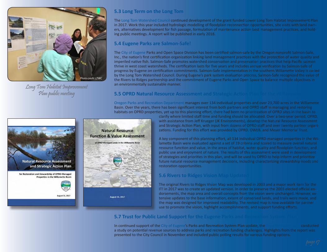
5.3 Long Term on the Long Tom
The Long Tom Watershed CouncilcontinueddevelopmentofthegrantfundedLowerLongTomHabitatImprovementPlanin2017.Workthisyearincludedhydrologicmodellingoffloodplainreconnectionopportunities,sitevisitswithlandown-ers,alternativesdevelopmentforfishpassage,formulationofmaintenanceactionbestmanagementpractices,andhold-ingpublicmeetings.Areportwillbepublishedinearly2018.
5.4 Eugene Parks are Salmon-Safe!
The CityofEugeneParksandOpenSpaceDivisionhasbeencertifiedsalmon-safebytheOregonnonprofitSalmon-Safe,Inc.,thenation’sfirstcertificationorganizationlinkinglandmanagementpracticeswiththeprotectionofwaterqualityandimperilednativefish.Salmon-SafepromoteswatershedconservationandpreservationpracticesthathelpPacificsalmonthriveinwestcoastwatersheds.ThecertificationlastsforfiveyearsandincludesannualverificationbySalmon-SafeofprogressbyEugeneoncertificationcommitments.Salmon-SafeimplementationinthesouthernWillametteValleyisco-ledbytheLongTomWatershedCouncil.DuringEugene’sparksystemevaluationprocess,Salmon-SaferecognizedthevalueoftheRiverstoRidgespartnershipandthecommitmentofEugeneParksandOpenSpacetobalancemultipleobjectivesinanenvironmentallysustainablemanner.
5.5 OPRD Natural Resource Assessment and Strategic Action Plan for the Willamette Basin
OregonParksandRecreationDepartmentmanagesover134individualpropertiesandover23,700acresintheWillametteBasin.Overtheyears,therehasbeensignificantinterestfrombothpartnersandOPRDstaffinmanagingandrestoringhabitatsonOPRDproperties,yetuptothisplanningeffort,therehadbeennoprioritizationofOPRDsitesinthebasinto
clarifywherelimitedstafftimeandfundingshouldbeallocated.Overatwo-yearperiod,OPRD,withassistancefromJeffKrueger(JKEnvironments),developtheNaturalResourceAssessmentandStrategicActionPlan,withinputfromdozensofOPRDstaffandovertwentypartnerorgani-zations.FundingforthiseffortwasprovidedbyOPRD,OWEB,andMeyerMemorialTrust.
Akeycomponentofthisplanningeffort,all134individualOPRD-managedpropertiesintheWil-lametteBasinwereevaluatedagainstasetof19criteriaandscoredtomeasureoverallnaturalresourcefunctionandvalue,intheareasofhabitat,waterqualityandfloodplainfunction,andpublicuseandenjoymentofnature.Theresultsofthisassessmentwereusedindevelopmentofstrategiesandprioritiesinthisplan,andwillbeusedbyOPRDtohelpinformandprioritizefuturenaturalresourcemanagementdecisions,includingcharacterizingstewardshipneedsandrestorationopportunities.
5.6 Rivers to Ridges Vision Map Updated
TheoriginalRiverstoRidgesVisionMapwasdevelopedin2003andamajorworkitemfortheIT!in2017wastocreateanupdatedversion.Inordertopreservethe2003electedofficialen-dorsements,themapareaandoverallconceptsfromthevisionwereunchanged.However,ex-tensiveupdatestothebaseinformation,extentofconservedlands,andtrailsweremade,andthemapwasdesignedforimprovedreadability.Therevisedmapisnowavailableforpartnerusetopromotethevision,highlightaccomplishments,andsupportfundingefforts.
5.7 Trust for Public Land Support for the Eugene Parks and Recreation System Plan
IncontinuedsupportoftheCityofEugene’sParksandRecreationSystemPlanupdate,theTrustforPublicLand conducted astudyonpotentialrevenuesourcestoaddressparksandrecreationfundingchallenges.HighlightsfromthereportwaspresentedtotheCityCouncilinNovemberandincludedpublicpollingresultsforvariousfundingoptions.
Long Tom Habitat Improvement Plan public meeting
page 17

page 18
6 Administrative Structure
FOG site visit to Staley Creek
2017 FOG Field Trips and Events:
• CoastForkTurtleFlatsProject(March7)
• BaldHillFarminCorvallis(April4)
• BufordRecreationArea(April20)
• CerroGordoviaRowPoint(May17)
• SnagboatBendTour(June13)
• GreenIslandandCoburgAggregateReclamationProject(July12)
• QuamashPrairie/ShortMountain(Sept.13)
• MeadowlarkEastManagementUnitatBufordPark(October11)
• StaleyCreekTour(November28)
6.1 Summary of Activities
Beginningin2010,theRiverstoRidgesPartnershiptookovertheadministrativefunctionthathadbeeninplaceundertheWestEugeneWetlands(WEW)Partnershipsince1992.TheWEWpartnershiphadoriginallyformedtooverseetheimple-mentationoftheWestEugeneWetlandsPlanbutovertimehadexpandeditsfocustoincludeamuchbroadergeographicarearepresentingarangeofadditionalhabitattypes.TheformationoftheR2Rpartnership,withtheadditionofseveralnewpartners,wasanacknowledgementofthisexpandedreach.ItisimportanttonotethattheR2Rpartnershiphasnooutsidefundingsourcesfortheadministrationofthepartnershipandcurrentlyreliesonvoluntaryannualpartnerdues,plusasignificantamountstafftimecontributedbypartners.ThebasicadministrativestructureusedbytheR2Rpartner-ship,isdescribedbelow.
6.1.1 Rivers to Ridges Executive Team (R2R XT)
ThefunctionoftheRiverstoRidgesExecutiveTeam(R2RXT)istoguidemanagementoftheregionalopenspacesysteminacooperativemanner.TheteamincludesatleastoneexecutiverepresentativefromeachmemberoftheR2RPartnershipandtypicallymeetsonceannually.The2017meetingwasheldonDecember4attheEugenePublicLibraryandwasfacili-tatedbyChrisOrsingerfromFriendsofBufordPark&MountPisgah.ThemeetingincludedtheadditionoftheMcKenzieWatershedCounciltothePartnership,RiverstoRidgesTeamupdates,IT!OutreachPlan,AccomplishmentpresentationfromPartners,R2RVisionMapupdate,andadiscussionofanexpandedR2Rvisionarea.
6.1.2 Rivers to Ridges Implementation Team (IT!)
TheRiverstoRidgesImplementationTeam(IT!)includesmanagerlevelrepresentativesfromeachofthepartnerorganiza-tions.TheIT!providesbroadoversightfortheimplementationoftheobjectivesoftheR2Rvision.TheIT!metapproxi-matelyahalfdozentimesin2017.ShellyMillerfromtheCityofEugenefacilitatedtheIT!meetingsin2017.
6.1.3 Rivers to Ridges Field Operations Group (FOG)
TheFieldOperationsGroup(FOG)isamulti-jurisdictionalteamthatmeetsseveraltimesannuallytocoordinateon-the-groundactivitiesandsharetechnicalinformationandexperience.ThemissionofFOG,asdefinedbytheIT!,isto“Effectivelycoordinateinformationsharingandprovideprofessionaldevelopmentopportunitiesthrougheduca-tionalpresentationsandprojectfieldtours.”
MuchofthecoordinationroleofFOGhasbeendelegatedtosubcommitteeswithgeneralmeetingsdedicatedtoguestlectures,trainings,orsitevisits.EmilyRingfromWil-lamalanescheduledandcoordinatedthe2017FOGmeet-ings and tours.
Rivers to Ridges on Facebook
The Rivers to Ridges Facebook page was created in 2016 and is currently being maintained by the Coast Fork
Willamette Watershed Council.
Please be sure to Like and Share!