road safety audit - massachusetts department of ... safety audit – washington street (routes 16...
TRANSCRIPT

ROAD SAFETY AUDIT
Washington Street
Town of Holliston
December 2012
Prepared for:
Prepared by: Howard/Stein-Hudson Associates
38 Chauncy Street Boston, MA 02111
Massachusetts Department of Transportation

Road Safety Audit – Washington Street (Routes 16 and 126), Holliston, MA Prepared by Howard/Stein-Hudson Associates, Inc.
Table of Contents Background ................................................................................................................................. 2
Project Data................................................................................................................................. 4
Project Location Description ..................................................................................................... 5
Road Safety Audit Observations ...............................................................................................7 Corridor-wide Issues ........................................................................................................................... 7 Location #1: Crosswalk South of Green Street/Exchange Street ...................................................... 10 Location #2: Green Street/Exchange Street/Washington Street Intersection ................................... 12 Location #3: Central Street/Washington Street Intersection Area .................................................... 13 Location #4: Mid-block Crosswalk between Central Street and Hollis Street/Charles Street ......... 16 Location #5: Hollis Street/Charles Street/Washington Street Intersection ........................................ 18 Location #6: Washington Street/Church Street ................................................................................. 20
Potential Safety Enhancements ...............................................................................................22
List of Appendices
Appendix A. RSA Meeting Agenda and Background Information Appendix B. RSA Audit Team Contact List
List of Figures
Figure 1. Locus Map.............................................................................................................................. 3
List of Tables
Table 1. Participating Audit Team Members ....................................................................................... 4 Table 2. Summary of Potential Safety Enhancements ....................................................................... 23
Page 1

Road Safety Audit – Washington Street (Routes 16 and 126), Holliston, MA Prepared by Howard/Stein-Hudson Associates, Inc.
Background The Washington Street corridor has long been a source of concern regarding transportation safety in the Town of Holliston. In the summer of 2012, the Holliston Police Department conducted a crash analysis study of the Holliston Downtown Square: 725 – 830 Washington Street between July 1, 2007, and July 1, 2012. A supplemental report was also prepared between July 1, 2012, and August 8, 2012. These reports were prepared at the request of the Holliston Board of Selectmen as a result of a crash in June 2012 involving two pedestrians in the crosswalk at the intersection of Washington Street and Central Street in addition to the long-standing safety concerns along the corridor.
As a result of the safety study conducted by the Police Department, the Holliston Police Chief reached out to the Massachusetts Department of Transportation (MassDOT), requesting a Road Safety Audit (RSA) along the segment of Washington Street (Routes 16 and 126) from the pedestrian crosswalk just to the south of the intersection of Exchange Street/Green Street to Church Street in the Town of Holliston. The RSA study area is illustrated in Figure 1.
Based on a review of the crash data provided by the Town, the corridor includes two locations, Washington Street at Central Street and Washington Street at Hollis Street/Charles Street, whose Equivalent Property Damage Only (EPDO) values put them within the top 5% of High Crash Locations within the Metropolitan Area Planning Council (MAPC) region. MassDOT has further determined that these locations would be eligible to receive Highway Safety Improvement Program (HSIP) funding for reconstruction should an RSA be conducted, and the proposed design incorporated the safety improvements identified in the RSA.
During the RSA, the audit team focused on safety issues along the entire corridor; however, the team also discussed specific safety issues at the intersections of Green Street/Exchange Street, Central Street, Hollis Street/Charles Street, and Church Street. The RSA audit team also discussed specific safety issues at three pedestrian crossing locations in this section of Washington Street including:
The raised crosswalk approximately 50 feet south of the Green Street/Exchange Street intersection;
The north crosswalk at the Central Street intersection; and
The mid-block raised crosswalk between Central Street and Hollis Street/Charles Street.
In general, the RSA is intended to identify potential safety improvements that can be evaluated and included as part of future design efforts for reconstruction. The short-term, low-cost potential improvements could be considered by the responsible agency for implementation prior to reconstruction, as appropriate.
Page 2

Figure 1. Locus Map
Road Safety Audit—Washington Street (Routes 16 and 126), Holliston, MA Prepared by Howard/Stein-Hudson Associates, Inc.
Source: Google Maps
RSA Study Area
Hollis St.
Exchange St.
Central St.Green St.
Charles St.
Church St.W
ashi
ngto
n St
.
Was
hingto
n St.
Elm St.
RSA Study AreaA RSRSRRR A
Not to scale.
RSA Study Area
Hollis St.
Exchange St.
Central St.Green St.
Charles St.
Church St.
Was
hing
ton
St.
Was
hingto
n St.
Elm St.
RSA Study AreaA RSRSRRR A
Howard/Stein-Hudson Associates, Inc. CREATIVE SOLUTIONS • EFFECTIVE PARTNERING ®

Road Safety Audit – Washington Street (Routes 16 and 126), Holliston, MA Prepared by Howard/Stein-Hudson Associates, Inc.
Project Data The audit team conducted a Road Safety Audit (RSA) along a roughly one-quarter mile segment of Washington Street (Routes 16 and 126) in Holliston, Massachusetts, on Wednesday, September 26, 2012. It should be noted that this date was a major religious holiday (Yom Kippur) and that schools in Holliston were closed. The RSA agenda and background material including the detailed crash data appear in Appendix A. Table 1 lists the audit team members and their affiliations. Appendix B provides detailed contact information for all team members.
Table 1. Participating Audit Team Members Audit Team Member Agency/Affiliation Carolyn Dykema Massachusetts House of Representatives Paul Lebeau Holliston Town Administrator Kevin Conley Holliston Board of Selectman
Jay Leary Holliston Board of Selectman Jay Marsden Holliston Board of Selectman Jack Donovan Holliston Planning Board
Chief John Moore Holliston Police Department Scott Downey Holliston Police Department Matthew Waugh Holliston Police Department
Michael Cassidy Holliston Fire Department Karen Sherman Holliston Town Planner Tom Smith Holliston Highway Department
Douglas Schmidt Brickhouse Realty (Local Business) Pam Zicko Holliston Business Owner Chenyuan Wang Boston Region MPO Lisa Schletzbaum MassDOT, Highway Division, Safety Section
Corey O’Connor MassDOT, Highway Division, Safety Section Joe Frawley MassDOT, District 3 Lola Campbell MassDOT, District 3
Bobby Blair Holliston Reporter Laura Krantz MetroWest Daily News Keri Pyke Howard/Stein-Hudson Associates, Inc.
Ted Brovitz Howard/Stein-Hudson Associates, Inc.
Prior to the RSA, and in order to begin assessing possible safety issues, the audit team reviewed collision diagrams, crash detail summaries, and speed regulations for this segment of Washington Street based on crash records supplied by the Holliston Police Department.
According to data provided by the Holliston Police Department, a total of 65 crashes were reported that occurred within the public right-of-way along this segment of Washington Street from June 2009 to June 2012. According to the records, crashes occurred throughout the year with a slight increase between May and July (or approximately 38% of the total). Crashes generally occurred throughout the week; however,
Page 4

Road Safety Audit – Washington Street (Routes 16 and 126), Holliston, MA Prepared by Howard/Stein-Hudson Associates, Inc.
approximately 29% of the crashes occurred on Fridays. The vast majority of crashes occurred between 6 AM and 6 PM (91%) and particularly in the afternoon between the hours of between 2:00 PM and 6:00 PM (approximately 42% of total crashes). The vast majority of crashes occurred during daylight conditions (89%), on clear days (62%), and on a dry roadway surface (80%). As the vast majority of crashes occurred during clear, daylight conditions on dry surfaces, this may indicate that speed could be a contributing factor to the number of crashes. However, this isn’t necessarily supported by the crash descriptions. The Holliston Police Department routinely provides traffic enforcement along this segment of Washington Street; the officers indicated that the majority of violations along this segment do not include speeding.
Of the 65 crashes, 34 (or 52%) involved angle crashes. Looking at the crash diagram, most of these crashes occurred at the side street intersections and driveways onto Washington Street. Another 17 crashes (26% of total) were rear-end collisions and another 7 (or 11%) were single vehicle crashes. Driver age does not appear to be a significant factor as crashes were distributed across all age groups with the highest number (12 crashes or 19% of the total) occurring in the 40-49 year age bracket.
In terms of driver contributing factors, the most common one was failure to yield right-of-way (22 or 34% of the total). Another 11 crashes (17%) were attributed to driver inattention; four (6%) were attributed to following too closely; and three (5%) were attributed to failure to keep in proper lane or running off the road. A total of 7 crashes (or 11%) were not attributed to improper driving. Of the 65 crashes, 12 (or 18%) involved injury. Additionally, four (6%) crashes involved bicycles, two (3%) involved pedestrians, and three (5%) involved parked vehicles.
Project Location Description The RSA focused on the segment of Washington Street (Routes 16 and 126) from the area just north of Church Street to the pedestrian crosswalk south of Green Street/Exchange Street in the Town of Holliston. The Washington Street corridor length is approximately 1/4-mile from the pedestrian crosswalk south of Green Street/Exchange Street to Church Street. Washington Street serves numerous institutional and commercial uses along the corridor and provides connection to surrounding residential neighborhoods, public parks, schools, and emergency services.
There are four intersections within the corridor: Green Street/Exchange Street, Central Street, Hollis Street/Charles Street, and Church Street. There are also several private driveways, some of which are heavily used throughout the day. There are no full stop-and-go traffic signals in this segment of the corridor.
Within the study area, Washington Street generally runs north-south and consists of one travel lane in each direction with left-turn lanes provided at key intersections and on-street parking. The corridor is approximately 65 feet wide. There are sidewalks located on both sides of Washington Street which extend along the intersecting public streets. There are three (3) designated pedestrian crosswalks, all of which have overhead flashing yellow pedestrian warning lights. The pedestrian crossing signals are activated through either push buttons or passive motion detection. Two of the crosswalks are also raised, requiring vehicles to slow as they pass over them. There are no designated bicycle lanes in the corridor.
Page 5

Road Safety Audit – Washington Street (Routes 16 and 126), Holliston, MA Prepared by Howard/Stein-Hudson Associates, Inc.
According to the MassDOT Office of Transportation Planning 2010 Road Inventory File, Washington Street is classified as a rural major collector and falls under local jurisdiction. The speed limit on Washington Street is 30 miles per hour (mph).
Green Street runs east-west and dead ends at a local park, which includes a field that can accommodate baseball, softball, or soccer games. Green Street is classified as a local street. Green Street consists of one narrow lane that can serve either direction. The road is approximately 20 feet wide. On–street parking is provided along the north side of the street. There are several residences located on the north side of the street.
Exchange Street runs east-west and provides one lane in each direction. There are a few marked on-street parking spaces on the south side near Washington Street. The land use along Exchange Street is primarily residential with the exception of the businesses at Washington Street, which include several banks. Exchange Street is classified as a local roadway. Exchange Street is stop-controlled at Washington Street.
Central Street is classified as a rural minor collector or urban collector and runs east-west, terminating at Washington Street. Central Street is approximately 30 feet wide and provides one lane in each direction. Marked on-street parking is provided on the north side of the street. The land use along Central Street is a mix of residential and commercial, with businesses located closest to Washington Street. The Town’s on-call Fire Department and Emergency Medical Services station is located on Central Street. Central Street is stop-controlled at Washington Street.
Hollis Street is an east-west roadway approximately 30 feet wide, providing one lane in each direction. The roadway widens as it approaches Washington Street to provide left/through and right-turn lanes. Hollis Street is stop-controlled at Washington Street. The First Congregational Church is located on the northwest corner of the intersection of Hollis Street/Charles Street/Washington Street. No on-street parking is provided on Hollis Street. With the exception of the church, the land use on Hollis Street is residential. Hollis Street is classified as a rural minor collector or urban collector, according to the 2010 MassDOT Road Inventory database.
Charles Street is an east-west roadway approximately 20 feet wide. No on-street parking is provided on Charles Street. The land uses along the street are primarily residential, although adjacent to Washington Street there are a few commercial properties as Charles Street nears Washington Street. Charles Street is classified as a local roadway. Charles Street is one-way eastbound at Washington; there is no exit from Charles Street onto Washington Street.
Church Street is an east-west local roadway approximately 24 feet wide, providing one lane in each direction. Left turns are not allowed from Church Street onto Washington Street southbound. Church Street is classified as a local roadway. On-street parking is not provided on Church Street.
Page 6

Road Safety Audit – Washington Street (Routes 16 and 126), Holliston, MA Prepared by Howard/Stein-Hudson Associates, Inc.
Road Safety Audit Observations Based on field observations on Wednesday, September 26, 2012, the RSA team determined that the Washington Street corridor segment between the pedestrian crosswalk south of the Exchange Street/Green Street intersection and Church Street has the following issues that affect safety:
Queuing conditions/driver frustration; Intersection and roadway geometry; Parking/access management; Pedestrian conditions; Bicycle conditions; and Intersection control.
The following sections describe in more detail the safety issues and potential enhancements determined during the RSA. Several of these issues require further study and engineering judgment to determine the feasibility of implementing enhancements to address them.
For the purposes of this RSA report, the discussion of safety issues along the Washington Street corridor is broken down into the following segments:
Corridor-wide Issues;
Location #1: Crosswalk South of Green Street/Exchange Street;
Location #2: Green Street/Exchange Street/Washington Street Intersection;
Location #3: Central Street/Washington Street Intersection Area;
Location #4: Mid-block Crosswalk between Central Street and Hollis Street/Charles Street;
Location #5: Hollis Street/Charles Street/Washington Street Intersection; and
Location #6: Church Street/Washington Street Intersection.
Corridor-wide Issues
Observations The following details the observations with respect to corridor-wide issues, such as speeding, queuing conditions/driver frustration,
Speeding
The posted speed limit is 30 mph through the Washington Street corridor. According to the Police Department, there isn’t a significant speeding issue in this segment of the corridor and very few tickets are issued by the department for speeding infractions. However, on-site observation
Page 7

Road Safety Audit – Washington Street (Routes 16 and 126), Holliston, MA Prepared by Howard/Stein-Hudson Associates, Inc.
gives the impression that vehicles are moving rapidly through this village business district setting. It was acknowledged by several participants that the 30 mph may be too fast given that the study area could be defined as a “thickly settled” area with a significant amount of vehicle turning, parking, and pedestrian interaction.
Queuing Conditions/Driver Frustration
Traffic volumes appeared to be moderate but consistent with limited gaps during the site visit, which was approaching noontime. RSA team members noted that high traffic volumes during peak hours, particularly in the afternoon, create queuing on the side streets. Some team members noted that, as a result of the infrequent gaps, drivers may be willing to accept a smaller gap to complete a turning movement onto Washington Street. The result is long queues on the intersecting streets and drivers taking chances, possibly resulting in a higher incidence of angle crashes. The long queues are also causing drivers to find alternative routes through local neighborhood streets. Participants also noted that there is a significant amount of truck traffic, which uses the corridor as a primary travel path to I-495.
Courtesy Crashes
According to several audit participants, several of the rear-end crashes along the corridor may be attributed to drivers making unanticipated stops to allow vehicles to enter from side streets or driveways, or to allow pedestrians to cross the street. Similarly, some angle crashes may be caused by a driver in one lane waving on a side street driver, who is then hit by the driver in the second lane, who doesn’t see the vehicle coming in from the side street. These “courtesy crashes” occurred throughout the corridor.
Driver inattention may be a contributing factor to rear- end crashes according to team members, including the use of cell phones. Team members also indicated that unexpected left-turning vehicles, occasional u-turning vehicles, and jaywalking pedestrians could be contributing factors to rear-end crashes along Washington Street.
The raised mid-block crosswalk between Central Street and Hollis Street/ Charles Street. The on-street parking spaces are located close to the crosswalk.
Page 8

Road Safety Audit – Washington Street (Routes 16 and 126), Holliston, MA Prepared by Howard/Stein-Hudson Associates, Inc.
Parking/Access Management
Site observations determined that several on-street parking spaces were located within a short distance to intersections, crosswalks, and driveways, within 10-15 feet in some cases. The proximity of on-street parking is reducing sight distance for vehicles turning onto Washington Street from the side streets and could be contributing to angle crashes. Further, the proximity of on-street parking spaces to crosswalks is reducing the visibility of pedestrians waiting to cross, even when the flashing beacons are activated. In some cases, a driver must enter a crosswalk in order to maneuver into a parallel on-street space, potentially creating an unsafe condition for pedestrians.
The corridor has a painted median throughout. However, the median does not deter motorists from making U-turns, and pedestrians have a longer distance to cross due to its presence.
Pedestrian Conditions
Site observations indicated a significant amount of pedestrian activity throughout the corridor. According to RSA team members, pedestrian activity is particularly high on Friday afternoons when local school children have no scheduled activities and tend to congregate in the village center. Other major pedestrian attractors are the local schools, Holliston Public Library, Goodwill Park, and the Community Children’s Center.
It was noted that although the flashing beacon systems at the pedestrian crosswalks were designed to be activated both by motion and by push button, it is not clear whether the motion detection is operational at all three locations. There have been issues with false calls related to the motion detectors, which has caused motorists to disregard the beacons.
Bicycling Conditions
There are no dedicated bicycle facilities along the corridor. According to some team members, those bicyclists that use the corridor are not stopping at the intersections. They also feel there is not a lot of bicycle activity along the corridor and significant increases are not expected in the future.
Potential Enhancements 1. Evaluate vehicle speeds in the area given the conditions through a speed study. Only if
the 85th percentile speeds are lower than 30 mph may a speed limit be reduced.
2. Study the Washington Street corridor to determine whether changes in intersection control at one or more locations could alleviate side street queuing without worsening Washington Street conditions and flow significantly. Changes in control such as the installation of one or more traffic signals could create gaps throughout the corridor for vehicles and pedestrians to complete maneuvers in a more safe and orderly fashion. A change in traffic control in one or more locations along the corridor may also eliminate
Page 9

Road Safety Audit – Washington Street (Routes 16 and 126), Holliston, MA Prepared by Howard/Stein-Hudson Associates, Inc.
the “courtesy crashes.” Also consider whether making some side streets one-way in pairs would benefit safety by reducing the number of conflict points.
3. Install curb extensions at the three existing crosswalks to shorten crossing distances, prevent motorists from parking too close to the crosswalks, and improve motorists’ visibility of a pedestrian waiting to cross.
4. Install curb extensions at driveways and intersection corners to prevent vehicles from parking too close and limiting sight distance.
5. Consider removing the painted median to narrow the roadway width. If the Town desires to maintain the median, consider whether installing a raised island would be beneficial for access management. In addition to providing access management, a raised median could also provide an opportunity for low planting, which would be aesthetically pleasing as well as providing a traffic calming effect. However, this could have an impact on area businesses that have driveways on Washington Street, effectively changing them to right-in, right-out access. However, there were four angle crashes at driveways, which could be eliminated through the installation of a raised median. The Town could test the median installation for a short time through the installation of temporary concrete median barrier.
6. Re-evaluate the locations and overall need for the three existing crosswalks across Washington Street in the study area. Consider the most appropriate locations with respect to adjacent intersecting driveways/roadways, lighting, visibility, and current pedestrian demand patterns.
7. Even though there is not a lot of bicycle activity in the study area, there were two crashes that involved bicyclists. Consider adding “sharrow” bicycle markings and “Share the Road” signs within the corridor.
Location #1: Crosswalk South of Green Street/Exchange Street This raised crosswalk extends approximately 65 feet from curb to curb across Washington Street. The crosswalk is not perpendicular to Washington Street but instead is skewed, making the crossing distance longer. According to the Holliston Police Department, the crosswalk was located south of the Green Street/Exchange Street intersection to accommodate the Mobil gas station
Green Street/Exchange Street. Page 10 Looking west at the raised crosswalk located just south of

Road Safety Audit – Washington Street (Routes 16 and 126), Holliston, MA Prepared by Howard/Stein-Hudson Associates, Inc.
curb cut, which is only about 15 feet south of the Green Street intersection.
The crosswalk is approximately 14 feet wide, raised, and marked with a red brick pattern and white outline. Triangular “yield mark” symbols are applied on the inclines up to the crosswalk in both the northbound and southbound directions to alert motorists of the change in grade.
Mast arm mounted flashing yellow beacons are located over the crosswalk and are visible from either direction. Only one mast arm pole, located on the east side of Washington Street, is used to suspend the beacons; as a result, the signal heads facing the Washington Street southbound traffic are not located directly over the Washington Street southbound lane. The flashing beacons are activated by both push button and motion detection. The motion detection at this location appeared to be inactive during the team’s site visit.
Observations Six crashes of the 65 within the study area occurred in the vicinity of the crosswalk. Four crashes involved Washington Street southbound vehicles, including one in which a pedestrian was injured. In the case of the pedestrian crash, the position of the flashing beacons may have been a contributing factor. Three of the seven crashes involved vehicles entering or exiting the Mobil gas station driveway. One crash involved a cyclist. Three of the crashes involved a sideswipe crash where a vehicle either turned improperly or was merging. These crashes may be a result of vehicles merging as they approach the crosswalk. One crash involved a vehicle exiting the Mobil gas station driveway just north of the crosswalk.
Team members commented that some drivers don’t stop for a pedestrian waiting to cross even with the beacons flashing. The flashing timing of the beacons doesn’t take into consideration the perception – reaction time and braking distance of a driver and may give a pedestrian a false sense that because they are flashing, it is safe to cross.
It was noted that the pavement markings on the upgrades of the raised crosswalk are not correct according to the MUTCD. The
marking used to indicate the change in elevation of the raised crosswalk should be a small solid triangle inscribed by a larger triangle, see the excerpt, MUTCD Figure 3B-30. If the markings are intended to be yield lines, they should be placed a minimum of four feet from the crosswalk, as outlined in Section 3B-16 of the MUTCD.
Page 11

Road Safety Audit – Washington Street (Routes 16 and 126), Holliston, MA Prepared by Howard/Stein-Hudson Associates, Inc.
Potential Enhancements 1. Consider installing a separate mast arm pole to suspend the flashing beacons directed at
the Washington Street southbound traffic over the center of the travel lane, improving their visibility for motorists.
2. Consider adding flashing beacons mounted at the roadside to the existing warning system. The addition of beacons at a height that doesn’t require a driver to look up to the flashing lights and then back to the crosswalk level may eliminate some of the rear-end crashes.
3. Consider adding a sound and/or light indication to alert a pedestrian that the warning system has been activated.
4. Evaluate the length of time the yellow beacons flash upon pedestrian activation to ensure that the interval is sufficient for a pedestrian to perceive that vehicles have yielded and complete the crossing at a typical walking speed.
5. Consider altering the geometry of Washington Street to prevent vehicles merging on Washington Street southbound in the vicinity of the crosswalk. This could be accomplished by moving the curblines to narrow the roadway or through changes in the pavement markings.
6. Install pavement markings to indicate the change in elevation of the raised crosswalk and/or yield lines as outlined in sections 3B-30 and 3B-16 of the MUTCD, respectively.
7. If the overall roadway width is not narrowed as suggested in Enhancement #5, consider installing curb extensions at the crosswalk to shorten the crossing distance for pedestrians.
8. Consider reconfiguring the driveway of the Mobil Station to shorten the crosswalk. At the same time consider closing one of the three existing driveways. This will require additional study to ensure that a gasoline tanker truck can access the station to make fuel deliveries.
Location #2: Green Street/Exchange Street/Washington Street Intersection
Observations It appears that the intersection is intended to be stop-controlled on the Green Street eastbound and Exchange Street westbound approaches. However, there is no STOP sign on the Green Street eastbound approach. There are crosswalks across both side streets as well. According to team members, there is a significant number of turning vehicles from both streets onto Washington Street. Exchange Street provides access to public parking and is a collector street for surrounding neighborhoods. There is a slight horizontal curve on Washington Street, which adds to the difficulty in exiting Green Street.
Page 12
Road Safety Audit – Washington Street (Routes 16 and 126), Holliston, MA Prepared by Howard/Stein-Hudson Associates, Inc.
Green Street provides access to Goodwill Park, a heavily-used public recreation facility that generates high traffic volumes and pedestrian activity during sporting events, especially during the non-winter months. There are a few on-street and off-street parking spaces on Green Street. Team members indicate that visitors to Goodwill Park frequently check on Green Street for parking before looking for other parking, which results in additional congestion as drivers recirculate to find parking. There is a municipal parking lot that can be accessed from Exchange Street. There is little wayfinding signage to indicate that off-street parking is available. However, many Holliston residents are aware of the municipal parking lot location, which results in pedestrian traffic from the lot crossing Washington Street to access the park. The location of the crosswalk at Washington Street is not in line with the pedestrian desire line.
There were four crashes of the 65 within the study area that occurred at the intersection. None of those crashes resulted in injury. Two crashes were angle collisions with a vehicle crossing from Exchange Street to Green Street being struck by a vehicle traveling southbound on Washington Street. One or both of these could be described as “courtesy crashes” in which an uninvolved third party waved the crossing vehicle through, only to have another vehicle go around the stopped courteous motorist. One crash involved a vehicle turning left from the Mobil gas station driveway colliding with a vehicle turning left from Exchange Street onto Washington Street southbound. One crash was a sideswipe in which a distracted driver started to turn from Washington Street northbound to Exchange Street, only to change his/her mind and swerve back into a passing vehicle.
It was also noted that the edge line on the Green Street eastbound approach is yellow, which is improper for a two-way street, according to the Manual on Uniform Traffic Control Devices (MUTCD). The intent was to convey that parking is not allowed on that side of the street.
Potential Enhancements 1. Install more prominent wayfinding signage directing motorists to the municipal
parking lot.
2. Consider signalizing the intersection in coordination with changes in intersection control at other corridor locations, including Central Street/Washington Street and Hollis Street/Charles Street/Washington Street. This will require additional study, including a warrant analysis of the intersection and capacity analysis of the corridor as a whole.
3. Consider removing the yellow edge line on Green Street eastbound. In order to convey that parking is not allowed, the MUTCD allows for painting the curb yellow.
Location #3: Central Street/Washington Street Intersection Area
Observations: There were 23 crashes of the 65 in the study area associated with the Central Street/Washington Street intersection and the area immediately to the north and south on Washington Street, including the crosswalk across Washington Street at Central Street and the driveway to the Holliston Superette parking area. Of those crashes, eight were rear-end crashes, several of which
Page 13

Road Safety Audit – Washington Street (Routes 16 and 126), Holliston, MA Prepared by Howard/Stein-Hudson Associates, Inc.
involved vehicles stopping for pedestrians. There were six crashes involving vehicles turning into or out of the Holliston Superette driveway, including one crash in which a cyclist was struck by a car exiting the driveway. Two crashes involved pedestrians that were hit and injured in the crosswalk across Washington Street at Central Street. Two collisions involved vehicles turning to or from Central Street onto Washington Street; both crashes involved left-turning vehicles. There were three crashes involving parked vehicles or fixed objects.
Audit team members expressed concern regarding the safety of pedestrians in the crosswalk across Washington Street. A motorist turning right from Central Street onto Washington Street northbound is looking left to determine whether there is a gap in the northbound traffic, and frequently does not look back to the right to determine whether there is a pedestrian in the crosswalk.
The stop bar on Central Street is set back from the intersection, forcing a vehicle to creep forward across the crosswalk to have sufficient sight distance.
Vehicles turning right from Washington Street northbound onto Central Street appear to be traveling at speeds that are too high over the crosswalk.
The stop bar on Central Street is set back from the intersection, due in part to the crosswalk location, and the buildings on the corner limit sight distance. A vehicle must creep forward over the crosswalk to improve sight distance in order to complete a turning maneuver. Pedestrians are then forced to walk between or behind a vehicle that has pulled forward over the crosswalk in order to see.
The mast arm holding the beacons facing Washington Street southbound is rotated
slightly so the beacons are not very visible until a motorist is close to it. The MUTCD notes that a typical application of a warning beacon is as an emphasis for a mid-block crosswalk. This location may be too close to the intersection of Central Street/Washington Street to be considered mid-block. Although the beacons at this location are centered over the travel lanes in both directions, there are no beacons on either side of Washington Street within the peripheral vision of a motorist. A motorist must look up to see the beacons and then back down to the roadway to perceive whether there is a pedestrian crossing.
Team members commented that some drivers don’t stop for a pedestrian waiting to cross even with the beacons flashing. The flashing timing of the beacons doesn’t take into consideration the perception – reaction time and braking distance of a driver and may give a pedestrian a false sense that because they are flashing, it is safe to cross.
Page 14

Road Safety Audit – Washington Street (Routes 16 and 126), Holliston, MA Prepared by Howard/Stein-Hudson Associates, Inc.
The wide expanse of unmarked pavement on Washington Street southbound between Green Street/Exchange Street and Central Street.
It was noted by team members that the Town has placed a police officer at the intersection of Central Street/Washington Street to direct traffic in the past, which provided more order and control at the intersection, improving safety.
A team member noted that the Washington Street southbound lane between Central Street and Green Street/Exchange Street is very wide, possibly more than two lanes wide, with no delineation. It was noted that this wide area may provide a refuge for a vehicle turning left out of Central Street when a vehicle continues to travel southbound on Washington Street after a southbound left-turning driver waves the Central Street driver out onto Washington
Street.
Team members noted that when the business on the northeast corner of the intersection of Central Street/Washington receives deliveries, the delivery vehicle frequently parks on the north side of Central Street, using the active travel lane, which can cause safety issues with a vehicle turning from Washington Street onto Central Street conflicting with a vehicle traveling west on Central Street.
Potential Enhancements 1. Consider changes to geometry in the area immediately surrounding the intersection of
Central Street. The roadway could be narrowed to shorten crossing distances, possibly widening sidewalks and/or creating angle parking on Washington Street. If angle parking is installed, consider utilizing reverse (or back-in) angle parking, which has many safety benefits compared to head-in angle parking.
2. Consider changes in lane configuration in concert with or instead of geometric changes on Washington Street between Green Street/Exchange Street and Central Street to define the lane use, particularly in the southbound direction. One option for considering would be the creation of a left-turn lane from Washington Street southbound onto Exchange Street. All options should be the subject of further study.
3. Consider installing a traffic signal at Central Street. A traffic signal would create gaps and improve vehicle and pedestrian safety. A signal at this location would provide the opportunity for an exclusive pedestrian phase, including pedestrian countdown signals. It could also include a crosswalk across the northbound approach of Washington Street, improving opportunities for a pedestrian to cross safely. A warrant analysis should be performed to determine whether the intersection warrants a signal. A study should be
Page 15

Road Safety Audit – Washington Street (Routes 16 and 126), Holliston, MA Prepared by Howard/Stein-Hudson Associates, Inc.
undertaken that considers all three intersections along the corridor to determine what configuration would be optimal to improve safety without adversely impacting capacity.
4. Consider relocating the pedestrian crossing to the south side of Central Street to eliminate the threat of a right-turning vehicle from Central Street onto Washington Street not seeing a pedestrian in the crosswalk.
5. Coordinate with the business owners regarding loading areas to prevent the creation of conflict areas. Consider the creation of a part-time loading zone for use by businesses.
6. Install curb extensions at the corners of the intersection encompassing the crosswalk to provide better protection and visibility for pedestrians as well as preventing vehicles from parking too close to the crosswalk and/or corners of the intersection. Several of these locations are currently marked out with pavement markings.
7. Consider adding flashing beacons mounted at the roadside to the existing warning system. The addition of beacons at a height that doesn’t require a driver to look up to the flashing lights and then back to the crosswalk level may increase perception – reaction time, thereby potentially eliminating some of the rear-end crashes.
8. Consider adding a sound and/or light indication to alert a pedestrian that the warning system has been activated.
9. Evaluate the length of time the yellow beacons flash upon pedestrian activation to ensure that the interval is sufficient for a vehicle to perceive that a pedestrian wants to cross and that the pedestrian can complete the crossing at a typical walking speed.
Location #4: Mid-block Crosswalk between Central Street and Hollis Street/Charles Street
Observations This crosswalk is located approximately halfway between Central Street and Hollis Street/Charles Street. Team members stated that many pedestrians use the crosswalk, but even in the crosswalk they don’t feel safe. Pedestrians hesitate in crossing, concerned that a driver may not see the flashing beacons. The flashing beacons can be activated by pedestrian pushbutton or by passive motion detectors. RSA team members noted that occasionally the beacons are activated and drivers cannot see whether a pedestrian is waiting to cross. It was also
A pedestrian in the mid-block noted that the passive motion activation sensors may be crosswalk between Central Street and Hollis Street/Charles Street.
Page 16

Road Safety Audit – Washington Street (Routes 16 and 126), Holliston, MA Prepared by Howard/Stein-Hudson Associates, Inc.
giving false calls, causing motorists to disregard the beacons. The crosswalk is very long as Washington Street is very wide at its location. It was also noted during the site visit that the length of time during which the beacons flash may not be long enough. A pedestrian waits to be sure vehicles have stopped, and by the time s/he completes the crossing, the beacons have stopped flashing.
All four beacons (2 each for the Washington Street northbound and southbound directions) are mounted on one mast arm pole; the mast arm pole is located on the west side of Washington Street at this location. As a result the beacons are not centered over the travel lanes in the Washington Street northbound direction, which may affect their visibility to motorists. There are no beacons on either side of Washington Street within the peripheral vision of a motorist, which forces a motorist to look up to perceive the beacons, then back down to the roadway to perceive whether a pedestrian is actually waiting to cross.
The sign (State Law Yield to Pedestrians) that is mounted between the flashing beacons is too small and doesn’t immediately convey the meaning that a pedestrian is likely in the crosswalk. The positioning of the beacons as well as the limited amount of information regarding the beacons’ purpose may cause confusion or lack of appropriate response by motorists. Other locations where a beacon is located overhead include a two-way stop controlled intersection. Perhaps drivers are associating the beacons on Washington Street as similar to an intersection with a flashing beacon and aren’t expecting a pedestrian but rather a vehicle at a side street.
It was noted that the pavement markings on the upgrades of the raised crosswalk are not correct according to the MUTCD. The marking used to indicate the change in elevation of the raised crosswalk should be a small solid triangle inscribed by a larger triangle, see MUTCD Figure 3B-30, shown previously in this report. If the markings are intended to be yield lines, they should be placed a minimum of four feet from the crosswalk, as outlined in Section 3B-16 of the MUTCD.
There were four crashes of the 65 within the study area at this location. All four crashes were rear-end crashes. There were no injuries. In most of these, the crash report noted that a vehicle was yielding for a pedestrian and was struck by the motorist behind, who was either following too closely or not paying attention.
Potential Enhancements 1. Install curb extensions encompassing the crosswalk to provide better protection and
visibility for pedestrians as well as preventing vehicles from parking too close to the crosswalk.
2. Install pavement markings to indicate the change in elevation of the raised crosswalk and/or yield lines as outlined in sections 3B-30 and 3B-16 of the MUTCD, respectively.
3. Consider adding a sound and/or light indication to alert a pedestrian that the warning system has been activated.
Page 17

Road Safety Audit – Washington Street (Routes 16 and 126), Holliston, MA Prepared by Howard/Stein-Hudson Associates, Inc.
4. Evaluate the length of time the yellow beacons flash upon pedestrian activation to ensure that the interval is sufficient for a driver to perceive and react to a pedestrian and complete the crossing at a typical walking speed.
5. Consider removing the passive motion activation sensors. They may be giving false calls to the system, causing motorists to disregard the flashing beacons when they are activated by a pedestrian.
6. Consider installing a separate mast arm pole to suspend the flashing beacons directed at the Washington Street northbound traffic over the center of the travel lane, improving their visibility for motorists.
7. Consider adding flashing beacons mounted at the roadside to the existing warning system. The addition of beacons at a height that doesn’t require a driver to look up to the flashing lights and then back to the crosswalk level may eliminate rear-end crashes.
8. Should the previous measures not be effective, consider changing the flashing beacon system to either a full-stop pedestrian signal with countdown pedestrian signal heads or to the High-intensity Activated crossWalK (HAWK) beacon system.
Location #5: Hollis Street/Charles Street/Washington Street Intersection
Observations From Hollis Street, left-turns onto Washington Street are challenging given the prevailing speed of traffic and limited gaps in the traffic due to the limited number of traffic controls in this segment of the corridor. RSA team members noted that at around 2:15 PM, a number of buses leave the high school, located west of Washington Street on Hollis Street, and proceed toward Washington Street. Most of the buses turn left onto Washington Street northbound from Hollis Street. Team members also noted during the site visit that a larger vehicle such as an SUV or school bus waiting on Hollis Street to turn left onto Washington Street northbound block sight distance for smaller vehicles waiting to turn right from Hollis Street to Washington Street southbound and vice versa.
Vehicles approaching Hollis Street on Washington Street southbound are perceived to have higher speeds because they are coming from a very wide section of roadway with a higher speed limit. The cross section of Washington Street at Hollis Street/Charles Street is still very wide, approximately 62 feet, including a painted median, a parking lane on each side, a general travel lane in each direction, and opposing left-turn lanes for both directions of Washington Street.
Page 18

Road Safety Audit – Washington Street (Routes 16 and 126), Holliston, MA Prepared by Howard/Stein-Hudson Associates, Inc.
A box truck waiting to turn left from Hollis Street onto Washington Street northbound.
Of the 65 crashes identified in the study area, 23 crashes occurred at this intersection, the same number as those that occurred in the vicinity of Central Street. Of those crashes, 17 were angle collisions. Eight of the angle collisions involved a vehicle turning left from Hollis Street to Washington Street northbound. An additional eight angle crashes involved vehicles proceeding east across Washington Street onto Charles Street from Hollis Street. There were 5 injury crashes, including one of the two crashes that involved a bicyclist.
Potential Enhancements 1. Consider installing “Do Not Block Intersection” signs and pavement markings to prevent
queued traffic on Washington Street from “blocking the box.” This should be considered carefully, as concern was expressed that this may result in an increase in “courtesy crashes.”
2. Consider a change in traffic control at the intersection. Possible changes could include a roundabout or a traffic signal. A roundabout would significantly reduce the number of injury crashes and slow traffic but has other potential impacts to right-of-way and may increase the emergency response time by the volunteer fire department. A traffic signal would create gaps and improve vehicle and pedestrian safety. A signal at this location would provide the opportunity for another safer pedestrian crossing location, including an exclusive pedestrian phase with pedestrian countdown signals. A warrant analysis should be performed to determine whether the intersection warrants a signal. A study should be undertaken that considers all three intersections along the corridor to determine what configuration would be optimal to improve safety without adversely impacting capacity.
3. Install curb extensions at the corners of the intersection to prevent vehicles from parking too close to the corners of the intersection as well as using an unoccupied parking lane to by-pass stopped traffic. Several of the corners are currently marked with pavement markings prohibiting parking. Drainage and snowplowing should be considered when installing curb extensions.
Page 19

Road Safety Audit – Washington Street (Routes 16 and 126), Holliston, MA Prepared by Howard/Stein-Hudson Associates, Inc.
Location #6: Washington Street/Church Street
Observations The painted median on the southern leg of Washington Street at Church Street is very wide; it was estimated at wider than 12 feet during the field visit. The painted median opposes an exclusive left-turn lane on Washington Street southbound at Church Street. A team member questioned whether such a median was necessary and what purpose it was serving. Left-turn movements are prohibited from Church Street. Although there is no physical barrier such as a median to prevent motorists from making the illegal left-turn, RSA team members including the Holliston Police Department members reported that most motorists obey the turn restriction.
Two of the 65 crashes within the study area occurred at this intersection. One involved an angle collision between a vehicle turning left from Washington Street southbound onto Church Street eastbound and a vehicle that exited an on-street parking space. The other was a rear-end crash on Church Street that had weather and pavement conditions as contributing factors in addition to driver inattention.
There is a bus stop for a MetroWest Regional Transit Authority (MWRTA) bus route located on the east side of Washington Street directly across from the First Congregational Church and south of the angle parking spaces. According to several team members, bus service is infrequent and not well utilized in the corridor.
There are no crosswalks across Washington Street at this location. There is a mid-block crossing approximately 170 feet north of Church Street at the entrance to Town Hall.
There is head-in angle parking on the east side of Washington Street just north of Church Street. The parking is primarily used by S. Mary’s Church during services and other activities on Sunday.
Potential Enhancements 1. Consider narrowing the Washington Street cross section by narrowing the painted median
island. The horizontal alignment of the entire Washington Street corridor should be considered when studying this potential enhancement.
2. Considering installing a narrower, raised, planted median in place of the painted median on the southern leg of Washington Street at Church Street. Consider how this change
An aerial view of the wide painted median at the intersection of Church Street/Washington Street.
Page 20
Road Safety Audit – Washington Street (Routes 16 and 126), Holliston, MA Prepared by Howard/Stein-Hudson Associates, Inc.
might fit with similar changes for the entire corridor. A raised, planted median could also serve as a traffic calming device as well as a gateway treatment and visual indicator to motorists that they are entering a business district.
3. Consider whether there is a need for a crosswalk across Washington Street at this location. This should be studied in conjunction with the other crossing locations in the corridor, including the mid-block crosswalk located to the north at Town Hall.
4. Although there were no reported crashes associated with the head-in angle parking in front of St. Mary’s church, consider changing the parking to reverse (or back-in) angle parking, which has improved safety benefits over traditional head-in angle parking.
Page 21

Road Safety Audit – Washington Street (Routes 16 and 126), Holliston, MA Prepared by Howard/Stein-Hudson Associates, Inc.
Potential Safety Enhancements Based on its observations and discussions, the RSA team identified the issues and possible enhancements that could improve safety along Washington Street within the study area.
Short-term enhancements include:
Perform a speed study of the corridor;
Study the crosswalk locations within the corridor;
Improve bicycle crossing conditions; and
Consider extending the time interval for crossing on each pedestrian warning beacon.
To enhance safety in the corridor, the long-term enhancements are to:
Evaluate changing the intersection traffic control at one or more locations in the corridor; and
Consider geometric changes to narrow the roadway.
Further study and design work need to be conducted to determine the feasibility of making such long-term improvements.
Table 2 summarizes these safety issues, possible enhancements, estimated safety payoff, time frame, cost, and responsibility. Safety payoff estimates are based on engineering judgment and are categorized as low, medium, and high. The time frame is categorized as short-term (<1 year), mid-term (1 to 3 years), or long-term (typically >3 years). Long-term improvements are typically considered to be substantial improvements with an expected time frame for implementation greater than 3 years. The costs are categorized as low (<$10,000), medium ($10,000 to $50,000), or high (>$50,000).
The RSA is intended to identify potential safety improvements that can be evaluated and included as part of future design efforts for reconstruction. The short-term, low-cost potential improvements could be considered by the responsible agency for immediate implementation, as appropriate.
Page 22
Road Safety Audit – Washington Street (Routes 16 and 126), Holliston, MA Prepared by Howard/Stein-Hudson Associates, Inc.
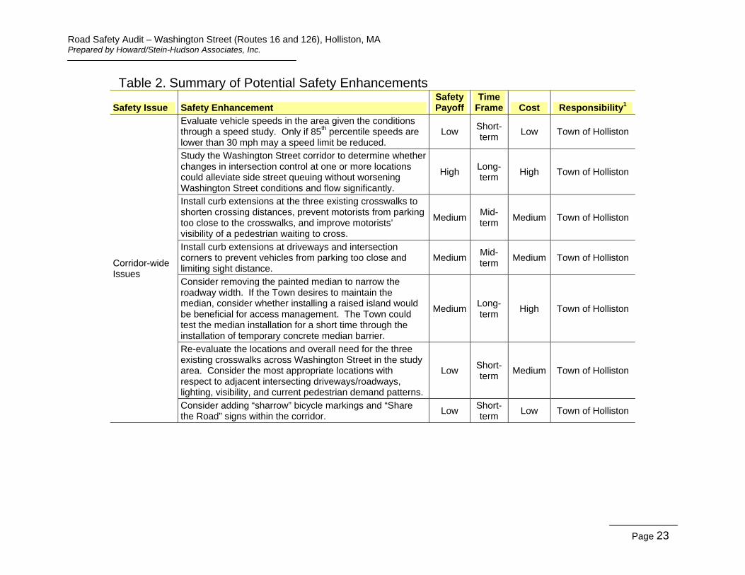
Table 2. Summary of Potential Safety Enhancements
Safety Issue Safety Enhancement Safety Payoff
Time Frame Cost Responsibility1
Corridor-wide Issues
Evaluate vehicle speeds in the area given the conditions through a speed study. Only if 85th percentile speeds are lower than 30 mph may a speed limit be reduced.
Low Short-term
Low Town of Holliston
Study the Washington Street corridor to determine whether changes in intersection control at one or more locations could alleviate side street queuing without worsening Washington Street conditions and flow significantly.
High Long-term
High Town of Holliston
Install curb extensions at the three existing crosswalks to shorten crossing distances, prevent motorists from parking too close to the crosswalks, and improve motorists’ visibility of a pedestrian waiting to cross.
Medium Mid-term
Medium Town of Holliston
Install curb extensions at driveways and intersection corners to prevent vehicles from parking too close and limiting sight distance.
Medium Mid-term
Medium Town of Holliston
Consider removing the painted median to narrow the roadway width. If the Town desires to maintain the median, consider whether installing a raised island would be beneficial for access management. The Town could test the median installation for a short time through the installation of temporary concrete median barrier.
Medium Long-term
High Town of Holliston
Re-evaluate the locations and overall need for the three existing crosswalks across Washington Street in the study area. Consider the most appropriate locations with respect to adjacent intersecting driveways/roadways, lighting, visibility, and current pedestrian demand patterns.
Low Short-term
Medium Town of Holliston
Consider adding “sharrow” bicycle markings and “Share the Road” signs within the corridor.
Low Short-term
Low Town of Holliston
Page 23

Road Safety Audit – Washington Street (Routes 16 and 126), Holliston, MA Prepared by Howard/Stein-Hudson Associates, Inc.
Table 2. Summary of Potential Safety Enhancements (Continued)
Safety Issue Safety Enhancement Safety Payoff
Time Frame Cost Responsibility1
Location #1: Crosswalk South of Green Street/ Exchange Street
Consider installing a separate mast arm pole to suspend the flashing beacons directed at the Washington Street southbound traffic over the center of the travel lane, improving their visibility for motorists.
Low Mid-term
Medium Town of Holliston
Consider adding flashing beacons mounted at the roadside to the existing warning system.
Medium Mid-term
High Town of Holliston
Consider adding a sound and/or light indication to alert a pedestrian that the warning system has been activated.
Low Short-term
Low Town of Holliston
Evaluate the length of time the yellow beacons flash upon pedestrian activation to ensure that the interval is sufficient for a pedestrian to perceive that vehicles have yielded and complete the crossing at a typical walking speed.
Medium Short-term
Low Town of Holliston
Consider altering the geometry of Washington Street to prevent vehicles merging on Washington Street southbound in the vicinity of the crosswalk. This could be accomplished by moving the curblines to narrow the roadway or through changes in the pavement markings.
High Long-term
High Town of Holliston
Correct the pavement markings to indicate the change in elevation of the raised crosswalk and/or yield lines as outlined in sections 3B-30 and 3B-16 of the MUTCD, respectively.
Low Short-term
Low Town of Holliston
If the overall roadway width is not narrowed through other methods, consider installing curb extensions at the crosswalk to shorten the crossing distance for pedestrians.
Medium Mid-term
Medium Town of Holliston
Consider reconfiguring the driveway of the Mobil Station to shorten the crosswalk. At the same time consider closing one of the three existing driveways. This will require additional study to ensure that a gasoline tanker truck can access the station to make fuel deliveries.
Low Long-term
Medium Town of Holliston
Page 24

Road Safety Audit – Washington Street (Routes 16 and 126), Holliston, MA Prepared by Howard/Stein-Hudson Associates, Inc.
Table 2. Summary of Potential Safety Enhancements (Continued)
Safety Issue Safety Enhancement Safety Payoff
Time Frame Cost Responsibility1
Location #2: Green Street/ Exchange Street/ Washington Street Intersection
Location #3: Central Street/ Washington Street Intersection Area
Install more prominent wayfinding signage directing motorists to the municipal parking lot. Consider signalizing the intersection in coordination with changes in intersection control at other corridor locations, including Central Street/Washington Street and Hollis Street/Charles Street/Washington Street. This will require additional study, including a warrant analysis of the intersection and capacity analysis of the corridor as a whole.
Consider removing the yellow edge line on Green Street eastbound. In order to convey that parking is not allowed, the MUTCD allows for painting the curb yellow. Consider changes to geometry in the area immediately surrounding the intersection of Central Street. The roadway could be narrowed to shorten crossing distances, possibly widening sidewalks and/or creating angle parking on Washington Street. If angle parking is installed, consider utilizing reverse (or back-in) angle parking, which has many safety benefits compared to head-in angle parking. Consider changes in lane configuration in concert with or instead of geometric changes on Washington Street between Green Street/Exchange Street and Central Street to define the lane use, particularly in the southbound direction. One option for consideration would be the creation of a left-turn lane from Washington Street southbound onto Exchange Street. All options should be the subject of further study. Consider installing a traffic signal at Central Street. A traffic signal would create gaps and improve vehicle and pedestrian safety. A study should be undertaken that considers all three intersections along the corridor to determine what configuration would be optimal to improve safety without adversely impacting capacity.
Low
High
Low
High
Medium
High
Short-term
Long-term
Short-term
Long-term
Short-term
Long
Low
High
Low
High
Low
High
Town of Holliston
Town of Holliston
Town of Holliston
Town of Holliston
Town of Holliston
Town of Holliston
Page 25

Road Safety Audit – Washington Street (Routes 16 and 126), Holliston, MA Prepared by Howard/Stein-Hudson Associates, Inc.
Table 2. Summary of Potential Safety Enhancements (Continued)
Safety Issue Safety Enhancement Safety Payoff
Time Frame Cost Responsibility1
Consider relocating the pedestrian crossing to the south side of Central Street to eliminate the threat of a right-turning vehicle from Central Street onto Washington Street not seeing a pedestrian in the crosswalk.
Low Mid-term
Medium Town of Holliston
Coordinate with the business owners regarding loading areas to prevent the creation of conflict areas. Consider the creation of a part-time loading zone for use by businesses.
Low Short-term
Low Town of Holliston
Location #3: Central Street/ Washington Street Intersection Area (Continued)
Install curb extensions at the corners of the intersection encompassing the crosswalk to provide better protection and visibility for pedestrians as well as preventing vehicles from parking too close to the crosswalk and/or corners of the intersection. Several of these locations are currently marked out with pavement markings.
Medium Mid-term
Medium Town of Holliston
Consider adding flashing beacons mounted at the roadside to the existing warning system.
Medium Mid-term
High Town of Holliston
Consider adding a sound and/or light indication to alert a pedestrian that the warning system has been activated.
Low Short-term
Low Town of Holliston
Evaluate the length of time the yellow beacons flash upon pedestrian activation to ensure that the interval is sufficient for a vehicle to perceive that a pedestrian wants to cross and that the pedestrian can complete the crossing at a typical walking speed.
Medium Short-term
Low Town of Holliston
Page 26

Road Safety Audit – Washington Street (Routes 16 and 126), Holliston, MA Prepared by Howard/Stein-Hudson Associates, Inc.
Table 2. Summary of Potential Safety Enhancements (Continued)
Safety Issue Safety Enhancement Safety Payoff
Time Frame Cost Responsibility1
Location #4: Mid-block Crosswalk between Central Street and Hollis Street/Charles Street
Install curb extensions encompassing the crosswalk to provide better protection and visibility for pedestrians as well as preventing vehicles from parking too close to the crosswalk.
Medium Mid-term
Medium Town of Holliston
Correct pavement markings to indicate the change in elevation of the raised crosswalk and/or yield lines as outlined in sections 3B-30 and 3B-16 of the MUTCD, respectively.
Low Short-term
Low Town of Holliston
Consider adding a sound and/or light indication to alert a pedestrian that the warning system has been activated.
Low Short-term
Low Town of Holliston
Evaluate the length of time the yellow beacons flash upon pedestrian activation to ensure that the interval is sufficient for a driver to perceive and react to a pedestrian and that the pedestrian can complete the crossing at a typical walking speed.
Medium Short-term
Low Town of Holliston
Consider removing the passive motion activation sensors. They may be sending false calls to the system, causing motorists to disregard the flashing beacons when they are activated by a pedestrian.
Low Short-term
Low Town of Holliston
Consider installing a separate mast arm pole to suspend the flashing beacons directed at the Washington Street northbound traffic over the center of the travel lane, improving their visibility for motorists.
Low Mid-term
High Town of Holliston
Consider adding flashing beacons mounted at the roadside to the existing warning system. The addition of beacons at a height that doesn’t require a driver to look up to the flashing lights and then back to the crosswalk level may eliminate rear-end crashes.
Medium Mid-term
High Town of Holliston
Should the previous measures not be effective, consider changing the flashing beacon system to either a full-stop pedestrian signal with countdown pedestrian signal heads or to the High-intensity Activated crossWalK (HAWK)beacon system.
Medium Long-term
High Town of Holliston
Page 27
Road Safety Audit – Washington Street (Routes 16 and 126), Holliston, MA Prepared by Howard/Stein-Hudson Associates, Inc.
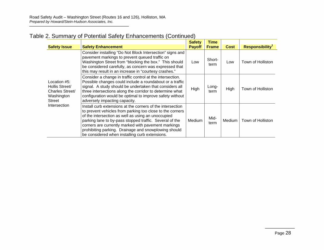
Table 2. Summary of Potential Safety Enhancements (Continued)
Safety Issue Safety Enhancement Safety Payoff
Time Frame Cost Responsibility1
Consider installing “Do Not Block Intersection” signs and pavement markings to prevent queued traffic on Washington Street from “blocking the box.” This should be considered carefully, as concern was expressed that this may result in an increase in “courtesy crashes.”
Low Short-term
Low Town of Holliston
Location #5: Hollis Street/ Charles Street/ Washington Street Intersection
Consider a change in traffic control at the intersection. Possible changes could include a roundabout or a traffic signal. A study should be undertaken that considers all three intersections along the corridor to determine what configuration would be optimal to improve safety without adversely impacting capacity.
High Long-term
High Town of Holliston
Install curb extensions at the corners of the intersection to prevent vehicles from parking too close to the corners of the intersection as well as using an unoccupied parking lane to by-pass stopped traffic. Several of the corners are currently marked with pavement markings prohibiting parking. Drainage and snowplowing should be considered when installing curb extensions.
Medium Mid-term
Medium Town of Holliston
Page 28

Road Safety Audit – Washington Street (Routes 16 and 126), Holliston, MA Prepared by Howard/Stein-Hudson Associates, Inc.
Table 2. Summary of Potential Safety Enhancements (Continued)
Safety Issue Safety Enhancement Safety Payoff
Time Frame Cost Responsibility1
Consider narrowing the Washington Street cross section by narrowing the painted median island. The horizontal alignment of the entire Washington Street corridor should be considered when studying this potential enhancement.
High Long-term
High Town of Holliston
Location #6: Church Street/ Washington Street Intersection
Considering installing a narrower, raised, planted median in place of the painted median on the southern leg of Washington Street at Church Street. Consider how this change might fit with similar changes for the entire corridor. A raised, planted median could also serve as a traffic calming device as well as a gateway treatment and visual indicator to motorists that they are entering a business district.
Medium Mid-term
Medium Town of Holliston
Consider whether there is a need for a crosswalk across Washington Street at this location. This should be studied in conjunction with the other crossing locations in the corridor, including the mid-block crosswalk located to the north at Town Hall.
Low Short-term
Medium Town of Holliston
Although there were no reported crashes associated with the head-in angle parking in front of St. Mary’s church, consider changing the parking to reverse (or back-in) angle parking, which has improved safety benefits over traditional head-in angle parking.
Low Short-term
Low Town of Holliston
Page 29

Road Safety Audit - Washington Street (Routes 16 and 126), Holliston, MA Prepared by Howard/Stein-Hudson Associates, Inc.
Appendix A. RSA Meeting Agenda and Background Information

COLLISION DIAGRAM
.c\
SYMBOLS TYPES OF CRASH SEVERITY Moving Vehicle Head On
(((.. Backing Vehicle _J Angle~ --------~ Non-Involved Vehicle · 0~
Injury Accident ~~ Pedestrian Turning Move t+-~l:s;;::l Parked Vehicle .., .. Rear End ~o Fixed Object 0
Fatal Accident Bicycle Sideswipe~c7<6 =v=: Animal - <:::;; 1S = • Out of Control~'f:;:-tP
CITYrTOWN : --L~~~::!...!..:::::::!..::L-_ ___:__ DATE PREPARED:
REGION: PREPARED BY:
TIME PERIOD ANALYZED:
SOURCE OF CRASH REPORTS:

10
20
30
40
50
60
Crash Data Summary Table Intersections on Washington Street (from Church St to Exchange St); Holliston, MA
June 2009 - June 2012
#
Crash Date Crash Day Time of Day Manner of Collision Light Condition
Weather Condition Road Surface Driver Contributing Code Ages Comments
1 6/17/09 Wednesday 7:02 AM Single Vehicle Crash Daylight Clear Dry No Improper Driving 46 Vehicle turning out of rear parking lot of 777 Washington St & hit bicyclist.
2 6/29/09 Monday 12:54 PM Angle Daylight Cloudy Wet Inattention 36 Vehicle hit parked vehicle while attempting to park.
3 7/17/09 Friday 8:42 AM Angle Daylight Clear Dry Inattention 39 Bicyclist attempted to cross roadway in front of vehicle.
4 8/14/09 Friday 11:20 AM Angle Daylight Clear Dry Failed to yield to right of way 51 18 Uninvolved vehicle in left turn lane on Washington St was obstructing the vision of vehicle exiting Hollis St.
5 9/13/09 Sunday 2:34 PM Rear-end Daylight Clear Dry Followed too closely 71 37 Uninvolved vehicle stopped abruptly for children crossing.
6 10/9/09 Friday 5:17 PM Angle Daylight Rain Wet Failure to keep in proper lane or running off road 61 48
7 10/23/09 Friday 3:37 PM Angle Daylight Cloudy Dry Failure to keep in proper lane or running off road 51 54 Uninvolved vehicle stopped to let Veh #1 cross intersection. Veh #2 went around ininvolved vehicle.
8 11/4/09 Wednesday 3:17 PM Angle Daylight Clear Dry Inattention 42 27
9 11/9/09 Monday 8:07 AM Rear-end Daylight Clear Dry Followed too closely 53 18 Veh #1 began to turn, then stopped. 11/9/09 Monday 12:13 PM Sideswipe, same direction Daylight Clear Dry No Improper Driving Unk Hit & run involving a parked vehicle.
11 11/14/09 Saturday 2:05 PM Rear-end Daylight Rain Wet Followed too closely 43 43 Wet pavement.
12 12/21/09 Monday 5:01 PM Angle Dark - lighted roadway Clear Dry Unknown 57 16
13 1/14/10 Thursday 10:17 AM Angle Daylight Clear Dry Failed to yield to right of way 78 16
14 2/12/10 Friday 10:52 AM Sideswipe, same direction Daylight Clear Dry Disregarded traffic signs, signals, road markings 48 64 Stopped Veh #1 waiting to turn left, Veh #2 attempted to pass on left.
15 2/18/10 Thursday 3:52 PM Single Vehicle Crash Daylight Clear Dry No Improper Driving 87 Vehicle hit pedestrian west of crosswalk.
16 3/20/10 Saturday 12:34 PM Rear-end Daylight Clear Dry Operating Vehicle in erratic, reckless, careless, negligent, or aggressive manner 56 48 Driver operating under influence of drugs.
17 4/20/10 Tuesday 9:21 PM Angle Dark - lighted roadway Clear Dry Failed to yield to right of way 56 17
18 4/21/10 Wednesday 11:35 AM Single Vehicle Crash Daylight Clear Dry Failed to yield to right of way 21 Vehicle hit pedestrian in crosswalk.
19 5/19/10 Wednesday 8:50 AM Angle Daylight Rain Wet Failed to yield to right of way 26 24 5/21/10 Friday 7:18 PM Angle Daylight Clear Dry Distracted 38 17
21 5/28/10 Friday 9:37 AM Angle Daylight Clear Dry Inattention 67 67 Veh #1 turning left from Exchange - Veh #2 turning left from Mobil Gas.
22 6/1/10 Tuesday 2:23 PM Angle Daylight Clear Dry No Improper Driving 70 16 Vehicle pulling out from parking space.
23 6/12/10 Saturday 1:09 PM Rear-end Daylight Rain Wet No Improper Driving 66 Unk Vehicle stopped abruptly for pedestrians - hit & run crash.
24 6/12/10 Saturday 1:13 PM Angle Daylight Cloudy Wet Failed to yield to right of way 63 52
25 6/26/10 Saturday 11:26 AM Rear-end Daylight Clear Dry No Improper Driving 63 63 Unk Vehicle slowed down to go over the raised crosswalk.
26 7/12/10 Monday 8:19 AM Rear-end Daylight Cloudy Dry Inattention 34 19 23
27 7/12/10 Monday 9:01 AM Angle Daylight Clear Dry Failed to yield to right of way 27 19
28 7/12/10 Monday 5:36 PM Rear-end Daylight Clear Dry Unknown 18 62 64
29 8/1/10 Sunday 3:53 PM Rear-end Daylight Clear Dry Inattention 55 19 11/18/10 Thursday 8:38 AM Angle Daylight Clear Dry Failed to yield to right of way 49 54
31 12/12/10 Sunday 7:47 AM Angle Daylight Snow Ice Unknown 60 77 Ice on roadway possibly caused crash.
32 12/17/10 Friday 4:27 PM Angle Dusk Clear Dry Failed to yield to right of way 71 20
33 12/22/10 Wednesday 2:21 PM Angle Daylight Snow Wet Failed to yield to right of way 19 45 Vehicle pulled out of parking space.
34 12/31/10 Friday 9:54 AM Rear-end Daylight Clear Dry Unknown 20 33 80
35 2/28/11 Monday 12:39 PM Angle Daylight Rain Wet Failed to yield to right of way 20 64 View obstructed by traffic.
36 3/8/11 Tuesday 5:44 PM Angle Daylight Clear Dry Distracted 45 39 Operator began to turn onto Exchange St but then changed mind.
37 3/10/11 Thursday 12:50 AM Single Vehicle Crash Dark - lighted roadway Clear Dry Physical Impairment 25 Driver was OUI and hit a light pole.
38 3/30/11 Wednesday 7:29 AM Rear-end Daylight Clear Dry Inattention 61 42 Vehicle stopped to let an uninvolved vehicle back out of lot onto Washington St.
39 4/1/11 Friday 8:51 AM Rear-end Daylight Freezing Rain Slush Inattention 45 31 5/17/11 Tuesday 5:22 PM Angle Daylight Rain Wet Failed to yield to right of way 23 22
41 5/26/11 Thursday 3:37 PM Angle Daylight Clear Dry Failed to yield to right of way 47 30 Unk Veh #1 turning into TD Bank hit Veh #2. Veh #2 hit parked Veh #3 injured pedestrian who was leaning against Veh #3.
42 6/10/11 Friday 8:08 PM Rear-end Dusk Clear Dry Unknown 20 20
43 7/6/11 Wednesday 1:25 PM Sideswipe, same direction Daylight Clear Dry Made an improper turn 36 48 Vehicle attempting to turn onto Central Street hit parked car.
44 7/20/11 Wednesday 3:59 PM Rear-end Daylight Clear Dry Inattention 65 45 Vehicle stopped for pedestrian in crosswalk.
45 7/21/11 Thursday 4:24 PM Angle Daylight Cloudy Dry Failure to keep in proper lane or running off road 66 30 Vehicle tried to go to the right of turning vehicle.
46 9/13/11 Tuesday 2:18 PM Single Vehicle Crash Daylight Clear Dry Inattention 51 47 Vehicle struck parked car.
47 11/2/11 Wednesday 6:11 PM Angle Dark - lighted roadway Clear Dry Failed to yield to right of way 71 51
48 11/18/11 Friday 3:12 PM Rear-end Daylight Clear Dry Failed to yield to right of way 34 67
49 12/2/11 Friday 3:04 PM Angle Daylight Clear Dry Made an improper turn 42 37 Vehicle stopped abruptly for a pedestrian in crosswalk. 12/23/11 Friday 11:38 AM Sideswipe, same direction Daylight Cloudy Dry Unknown 35 26
51 1/10/12 Tuesday 2:00 PM Angle Daylight Clear Dry Failed to yield to right of way 46 43
52 1/20/12 Friday 7:56 AM Rear-end Daylight Clear Wet Unknown 48 71
53 2/2/12 Thursday 4:51 PM Angle Dusk Cloudy Dry Unknown 32 62
54 2/16/12 Thursday 3:03 PM Single Vehicle Crash Daylight Cloudy Dry Failed to yield to right of way 93
55 4/13/12 Friday 4:35 PM Angle Daylight Cloudy Dry Unknown 73 72
56 4/23/12 Monday 10:31 AM Angle Daylight Cloudy Wet Unknown 48 48
57 5/7/12 Monday 12:28 PM Angle Daylight Clear Dry Failed to yield to right of way 50 26 Vehicle crossing over Washington St had to stop abruptly for pedestrian in crosswalk on Charles St.
58 5/18/12 Friday 3:59 PM Rear-end Daylight Clear Dry Followed too closely 43 30 Slowing for pedestrian in crosswalk.
59 5/31/12 Thursday 6:13 PM Sideswipe, same direction Daylight Cloudy Dry Inattention 63 Operator on cell phone. 6/8/12 Friday 7:54 AM Angle Daylight Cloudy Dry Failed to yield to right of way 30 35
61 6/16/12 Saturday 1:57 PM Head on Daylight Clear Dry Unknown 19 Uninvolved vehicle blocked the view of the pedestrians.
62 1/10/10 Sunday 2:43 PM Single Vehicle Crash Daylight Cloudy Dry Failed to yield to right of way 32 17
63 10/22/10 Friday 2:12 PM Angle Daylight Cloudy Dry Failed to yield to right of way 70 17
64 6/4/09 Thursday 7:48 AM Sideswipe, same direction Daylight Cloudy Dry No Improper Driving 62 Unk Operator 2 attempted to turn right into Mobil, Operator 1 attempted to pass on right. Hit & run crash. 65 9/9/10 Thursday 12:40 PM Angle Daylight Cloudy Dry Failed to yield to right of way 56 28
Summary based on Crash Reports obtained from the Holliston Police Department

Crash Data Summary Tables and Charts Intersections on Washington Street (from Church St to Exchange St); Holliston, MA
0%
5%
10%
15%
20%
CRASH MONTH
6% 8%
6% 8%
12% 15%
11%
3% 5% 5%
11% 11%
J F M A M J J A S O N D
0%
10%
20%
30%
40% CRASH DAY OF WEEK
15% 9%
14% 17%
29%
9% 6%
Monday Tuesday Wednesday Thursday Friday Saturday Sunday
0% 10% 20% 30% 40% 50%
CRASH TIME OF DAY
23% 26%
42%
8% 2% 0%
6-10AM 10-2PM 2-6PM 6-10PM 10-2AM 2-6AM
0% 10% 20% 30% 40% 50% 60%
CRASH MANNER OF COLLISION
11%
26%
9% 0% 2% 0% 0%
52%
Single Vehicle Crash
Rear-end Angle Sideswipe, same
direction
Sideswipe, opposite direction
Head on Rear to Rear
Unknown
Crash Summary Data Washington Street.xls 1 of 2 9/13/2012

Crash Data Summary Tables and Charts Intersections on Washington Street (from Church St to Exchange St); Holliston, MA
0% 20% 40% 60% 80%
100% CRASH LIGHT CONDITION
89%
0% 5% 6% 0% 0% 0%
Daylight Dawn Dusk Dark -Lighted
Roadway
Dark -Roadway not lighted
Dark -unknown roadway lighting
Other
0%
Unknown
0% 10% 20% 30% 40% 50% 60% 70%
CRASH WEATHER CONDITION 62%
25%
9% 3% 2% 0% 0% 0% 0%
Cle
ar
Clo
udy
Rai
n
Sno
w
Sle
et, H
ail,
Fre
ezin
gR
ain
Fog
, Sm
og,
Sm
oke
Sev
ere
Cro
ssw
inds
Blo
win
gsa
nd, s
now
Oth
er
0%
Unk
now
n
0%
20%
40%
60%
80%
100% CRASH ROAD SURFACE
80%
17% 0% 2% 0% 0% 2% 0%
Dry Wet Snow Ice Sand, mud, dirt, oil, gravel
Water (standing, moving)
Slush Other
0%
Unknown
0% 5%
10% 15% 20% 25%
CRASH DRIVER AGES
13% 14% 16% 19%
12% 16%
8%
15-20 21-29 30-39 40-49 50-59 60-69 70-79
3%
80+
Crash Summary Data Washington Street.xls 2 of 2 9/13/2012

Road Safety Audit - Washington Street (Routes 16 and 126), Holliston, MA Prepared by Howard/Stein-Hudson Associates, Inc.
Appendix B. RSA Audit Team Contact List