roads construction interior - wellington county, ontario
TRANSCRIPT

1
County of Wellington
Salem Bridge, No. 018050Woolwich Street West (Wellington Road 18) Municipal Class Environmental Assessment (EA) Study

WelcomeWelcome to the Online Public Information Centre (PIC) for this ClassEA Study. We invite you to sign-in online by visiting:
https://goo.gl/quat4Y
We encourage your input/feedback on the materials presentedthrough this Online PIC. Questions or comments can be submittedonline via the URL listed above, or by mail/fax/email to:
A comment sheet is available for download on the County’s website.Background reports are available upon request.
There is an opportunity at any time during the EA process forinterested persons to provide written input. Any comments receivedwill be collected under the Environmental Assessment Act and, withthe exception of personal information, will become part of the publicrecord.
Mr. William Van Ruyven, P.Eng.,Consultant Project Manager
WSP610 Chartwell Road
Suite 300Oakville ON L6J 4A5
T 905.823.8500F 905.823.8503
2
County of WellingtonSalem Bridge, No. 018050
Woolwich Street West (Wellington Road 18) Municipal Class Environmental Assessment (EA) Study
Introduction
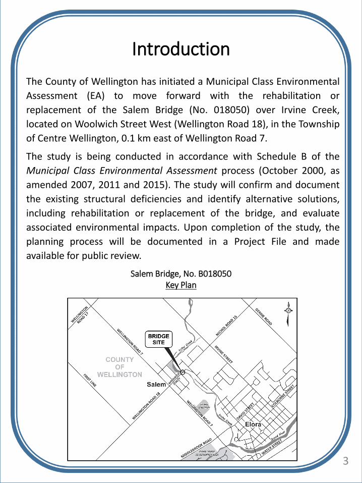
The County of Wellington has initiated a Municipal Class Environmental
Assessment (EA) to move forward with the rehabilitation or
replacement of the Salem Bridge (No. 018050) over Irvine Creek,
located on Woolwich Street West (Wellington Road 18), in the Township
of Centre Wellington, 0.1 km east of Wellington Road 7.
The study is being conducted in accordance with Schedule B of the
Municipal Class Environmental Assessment process (October 2000, as
amended 2007, 2011 and 2015). The study will confirm and document
the existing structural deficiencies and identify alternative solutions,
including rehabilitation or replacement of the bridge, and evaluate
associated environmental impacts. Upon completion of the study, the
planning process will be documented in a Project File and made
available for public review.
3
Salem Bridge, No. B018050Key Plan

Study Area Aerial
4

The Municipal Class Environmental Assessment (Class EA) is anapproved process for planning and designing municipal projects,including roads and bridges. The Class EA describes the process thatproponents must follow in order to meet the requirements of theProvincial EA Act.
Based on the scope of this project, the rehabilitation or replacementof Salem Bridge is being undertaken as a Schedule ‘B’ Class EA, whichwill follow Phases 1 and 2 outlined below and be documented in aProject File, which is a detailed compilation of all data and reportsproduced for the project.
Municipal Class Environmental Assessment (EA) Process
WE ARE HERE
5
Need and Justification
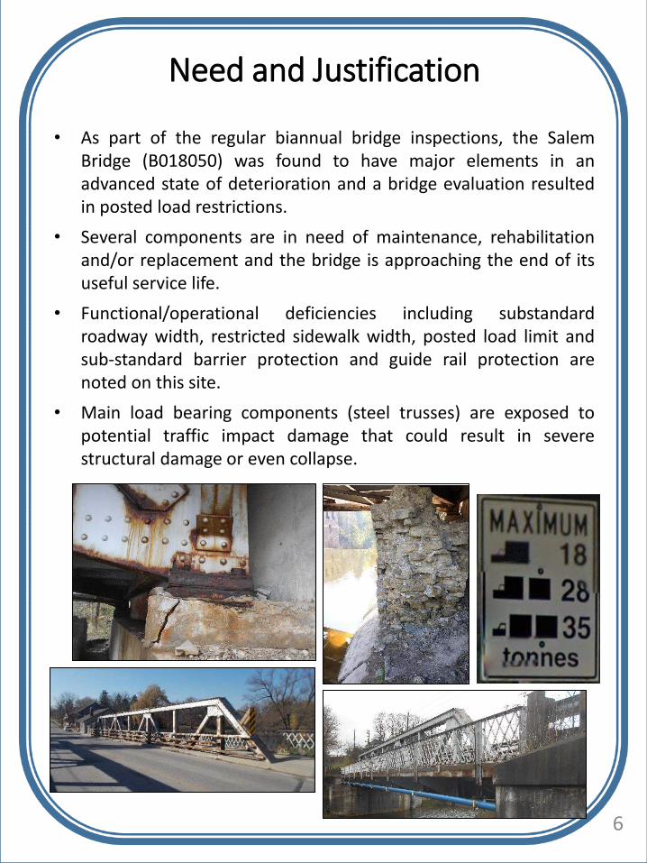
• As part of the regular biannual bridge inspections, the SalemBridge (B018050) was found to have major elements in anadvanced state of deterioration and a bridge evaluation resultedin posted load restrictions.
• Several components are in need of maintenance, rehabilitationand/or replacement and the bridge is approaching the end of itsuseful service life.
• Functional/operational deficiencies including substandardroadway width, restricted sidewalk width, posted load limit andsub-standard barrier protection and guide rail protection arenoted on this site.
• Main load bearing components (steel trusses) are exposed topotential traffic impact damage that could result in severestructural damage or even collapse.
6
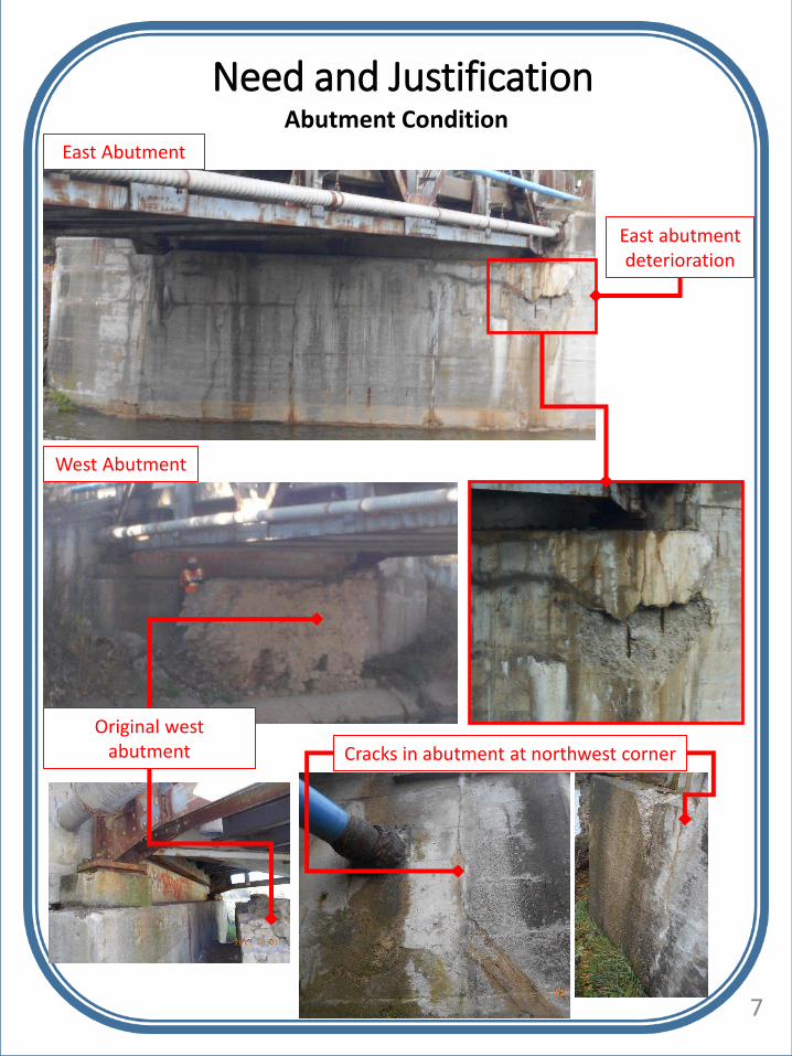
Need and JustificationAbutment Condition
Cracks in abutment at northwest corner
7
East Abutment
West Abutment
Original west abutment
East abutment deterioration
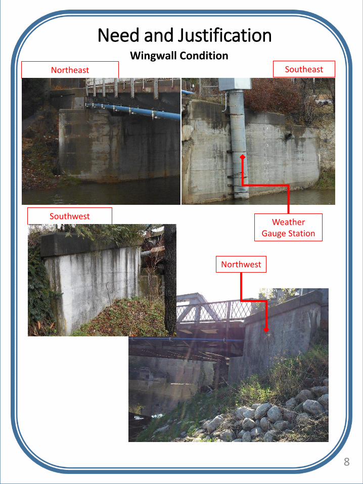
Need and JustificationWingwall Condition
SoutheastNortheast
8
SouthwestWeather
Gauge Station
Northwest

Need and JustificationDeck Soffit Condition
Typical north sidewalk cantilever
Full depth cracks through northwest sidewalk
9
Typical deck soffit (midspan)

Need and Justification
10
Truss Condition
Typical north sidewalk cantilever
Stringer with corrosion and section loss
Coating failure throughout (typical)
Local rust jacking and plate distortion identified
Full depth deterioration

Sidewalk pedestrian railing
Need and Justification
11
Barrier System
South traffic barrier (typical)
Missing mid-height rail on north traffic
barrier

Joint Systems
Need and Justification
East
12
Bearing Systems
West
Spall at northwest sidewalk
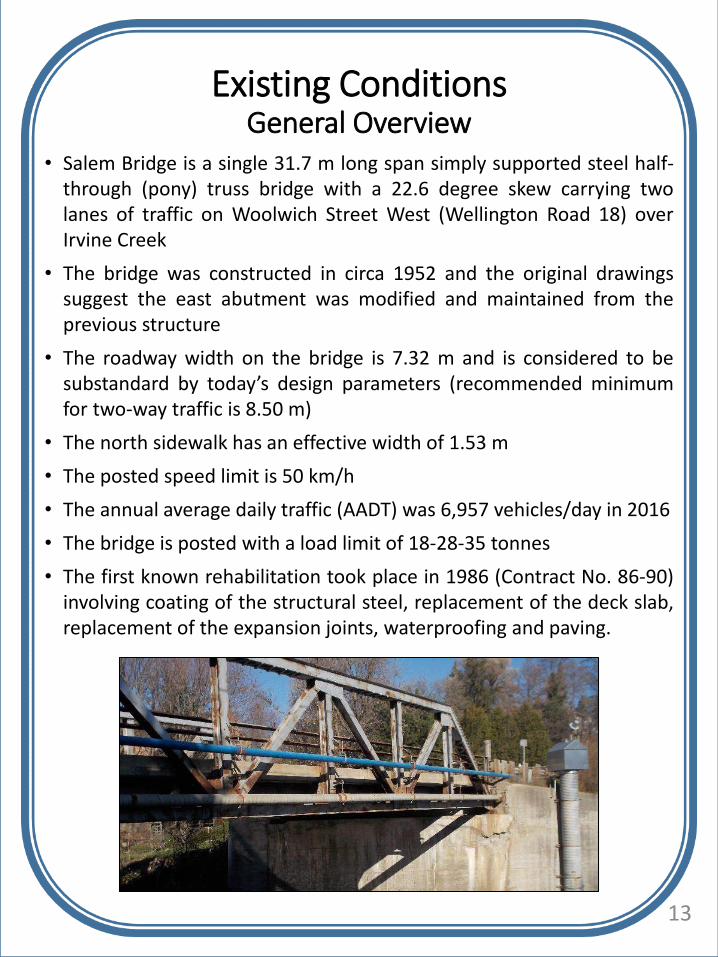
• Salem Bridge is a single 31.7 m long span simply supported steel half-through (pony) truss bridge with a 22.6 degree skew carrying twolanes of traffic on Woolwich Street West (Wellington Road 18) overIrvine Creek
• The bridge was constructed in circa 1952 and the original drawingssuggest the east abutment was modified and maintained from theprevious structure
• The roadway width on the bridge is 7.32 m and is considered to besubstandard by today’s design parameters (recommended minimumfor two-way traffic is 8.50 m)
• The north sidewalk has an effective width of 1.53 m
• The posted speed limit is 50 km/h
• The annual average daily traffic (AADT) was 6,957 vehicles/day in 2016
• The bridge is posted with a load limit of 18-28-35 tonnes
• The first known rehabilitation took place in 1986 (Contract No. 86-90)involving coating of the structural steel, replacement of the deck slab,replacement of the expansion joints, waterproofing and paving.
Existing ConditionsGeneral Overview
13
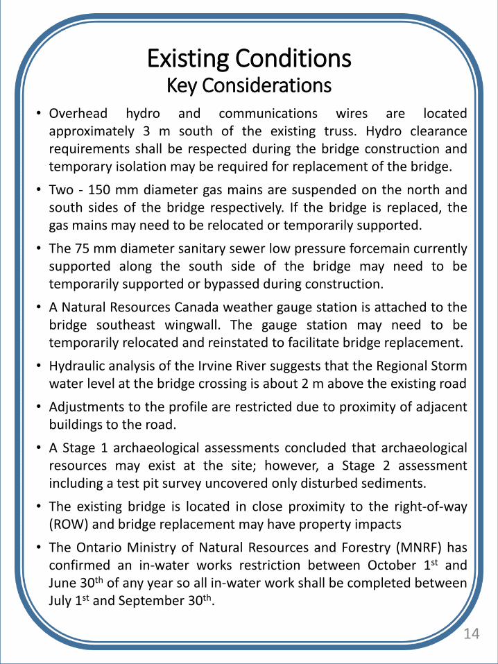
• Overhead hydro and communications wires are locatedapproximately 3 m south of the existing truss. Hydro clearancerequirements shall be respected during the bridge construction andtemporary isolation may be required for replacement of the bridge.
• Two - 150 mm diameter gas mains are suspended on the north andsouth sides of the bridge respectively. If the bridge is replaced, thegas mains may need to be relocated or temporarily supported.
• The 75 mm diameter sanitary sewer low pressure forcemain currentlysupported along the south side of the bridge may need to betemporarily supported or bypassed during construction.
• A Natural Resources Canada weather gauge station is attached to thebridge southeast wingwall. The gauge station may need to betemporarily relocated and reinstated to facilitate bridge replacement.
• Hydraulic analysis of the Irvine River suggests that the Regional Stormwater level at the bridge crossing is about 2 m above the existing road
• Adjustments to the profile are restricted due to proximity of adjacentbuildings to the road.
• A Stage 1 archaeological assessments concluded that archaeologicalresources may exist at the site; however, a Stage 2 assessmentincluding a test pit survey uncovered only disturbed sediments.
• The existing bridge is located in close proximity to the right-of-way(ROW) and bridge replacement may have property impacts
• The Ontario Ministry of Natural Resources and Forestry (MNRF) hasconfirmed an in-water works restriction between October 1st andJune 30th of any year so all in-water work shall be completed betweenJuly 1st and September 30th.
Existing ConditionsKey Considerations
14

Bridge Description
• Constructed in 1952
• Fourth oldest and third longest of the five remaining Warren PonyTruss structures in the County of Wellington
• Designed by County of Wellington Engineer William H. Keith. Thecontractor was Albert Reeves and the Hamilton Steel Companyfabricated the steel superstructure
Current Heritage Status of Bridge
• Not Listed on Municipal Heritage Register
• Identified as a heritage resource in the publication Arch, Truss &Beam: The Grand River Heritage Bridge Inventory (March 2013)
• Not designated under Ontario Heritage Act (OHA)
Cultural Heritage Evaluation (CHER)
• Salem Bridge identified through the Cultural Heritage Evaluation asmeeting one or more of the “Criteria for Determining CulturalHeritage Value or Interest” under Ontario Regulation 9/06 and istherefore worthy of consideration for registering on a municipalheritage register or municipal designation under Part IV of the OHA
A copy of the CHER is available upon request.
Existing ConditionsCultural Heritage
(View of Salem Bridge looking southeast, 1968) 15
Existing ConditionsNatural Environment
16

Existing ConditionsNatural Environment (Continued)
17
Policy Designated Features
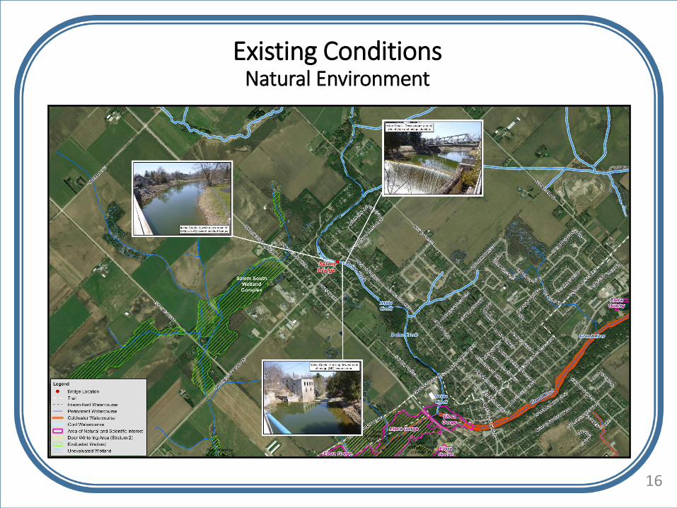
• There are no designated features in the vicinity of the crossing.
• The Township of Centre Wellington OfficialPlan (2008) identifies Irvine Creek and itsriparian corridor as ‘Core Greenlands’ in thevicinity of the bridge.
• Irvine Creek and its associated floodplain isregulated by the Grand River ConservationAuthority (GRCA) under Reg. 150/06.

Existing and Key Natural Features
• Irvine Creek and its riparian corridor is the most prominent naturalfeature in the vicinity of the bridge. A dam structure locatedapproximately 18 m downstream of the bridge (a barrier to fishmovement), has created a large impoundment/ponded feature(approximately 50 m wide at its widest point), that extendsapproximately 360 m back to Washington Street. Irvine Creek isclassified by MNRF as ‘warmwater’ in the vicinity of the bridge and‘coldwater’ downstream of the dam.
• Land Information Ontario (LIO) data indicates that Irvine Creeksupports a range of warm, cool and cold water fish speciesincluding: Bluntnose Minnow, Brassy Minnow, Central Mudminnow,Common Shiner, Creek Chub, Eastern Blacknose Dace, HornyheadChub, Iowa Darter, Longnose Dace, Mottled Sculpin, Least Darter,River Chub, Rock Bass, Rosyface Shiner, Smallmouth Bass andWhite Sucker. MNRF has also indicated that Brown Trout are founddownstream of the dam.
Existing ConditionsNatural Environment (Continued)
18
• Terrestrial habitats in the immediatevicinity of the Bridge include commonroadside vegetation communities andplanted residential trees and shrubs.
• The Bridge provides habitat fornesting birds. Two old nests and oneactive nest belonging to EasternPhoebe, were observed on theunderside of the bridge. Migratorybirds are protected under theMigratory Birds Convention Act(MBCA).

Existing ConditionsNatural Environment (Continued)
Species at Risk (SAR)
• The Endangered Species Act (ESA) provides species and habitatprotection for Threatened and Endangered species only.
• MNRF indicated they have no records of SAR in the vicinity of thebridge; however, WSP observed a SAR Snapping Turtle (SpecialConcern under ESA) during a field visit.
• The Natural Heritage Information Centre (NHIC) database listed oneSAR within a 2 km radius of the bridge site: Black Redhorse(Threatened under ESA)
• Regulated Redside Dace (listed as Endangered under ESA) habitat isfound approximately 24 km upstream of the bridge and will not beimpacted by the proposed works.
• Potential habitat for an additional two other SAR: Barn Swallow(Threatened under ESA) and Northern Map Turtle (Special Concernunder ESA) in the vicinity of the bridge was identified during fieldsurveys.
• Chimney Swift (Threatened under ESA), Common Nighthawk (SpecialConcern under ESA), Eastern Small-footed Myotis (Endangeredunder ESA), Little Brown Myotis (Endangered under ESA) andMonarch butterfly (Special Concern under ESA) may forage overheadof the study area or within the general vicinity of the bridge;however, potential breeding habitat for these species occurs beyondthe ROW and will not be impacted by the proposed works.
• Potential impacts to the above SAR species and habitat are not anticipated with appropriate mitigation measures.
19

• MTO Drainage Design Standards for a 50 years storm are notaccommodated by the existing structure.
• The existing Bridge does not have enough clearance / freeboardduring design floods and overtops during Regional Storm events (i.e.Hurricane Hazel). Since the existing bridge is not drivable duringRegional floods, its current viability as an emergency route islimited.
• It is noted that Flood Frequency Analysis flows used for thehydraulic evaluation may be significantly conservative (especially theRegional storm) and result in more deficiencies than wouldotherwise be reasonable. For example, during a regional stormevent the results suggest that the township would be under water.
• A copy of the Hydraulic Assessment Memorandum is available uponrequest.
Existing ConditionsWater Resources
20

Based on the assessment of the existing Salem Bridge and an overviewof the area features, the problem being addressed is described asfollows:
• The bridge is in an advanced state of deterioration
• The bridge has deficient barrier protection
• The bridge is posted with a load limit
• The bridge has narrow shoulders and has substandard roadwaywidth
• The bridge has a restricted sidewalk width
Overall, the existing Salem Bridge is in poor condition with a number offunctional and operational deficiencies. The Bridge is at the end of itsuseful service life.
The cost of maintaining the current bridge under a rehabilitationapproach may meet or exceed the cost of replacement options andtherefore the EA Study has been initiated to define the mostappropriate bridge management strategy to carry forward.
Problem (Deficiency) or Opportunity Statement
21

Option 1 – Do Nothing
• Work on the structure is not included; therefore, the structure
condition would be monitored regularly until a full road closure is
warranted.
Option 2 – Rehabilitate
• Rehabilitation is anticipated to include deck repairs, new
waterproofing, replacement of expansion joints, bearing
replacement, abutment repairs, cleaning and coating of the
existing steel truss in addition to structural steel repairs and local
strengthening in order to eliminate the need for load posting.
Option 3 – Replace
• Includes removal of the existing truss structure and replacing it
with a new bridge.
• The proposed bridge replacement will include a reinforced
concrete deck on precast NU I-girders with semi-integral
abutments.
Road Closure / Detour
• Full road closure will be required for Options 2 & 3 with a detour
likely including Geddes to David St. to Wellington Road 7 which is
estimated to be approximately 3.5 km.
• For Option 1 a similar detour would eventually be required.
Alternative Solutions
22

Evaluation Criteria
• Roadway Geometrics, including drainage, grades, horizontal curves
• Transportation / Traffic Maintenance, including existing andfuture traffic operations, emergency vehicle access, flexibility forstaged construction
• Structure, including advanced state of deterioration, structuraldeficiencies, functional deficiencies, operational deficiencies,barrier deficiencies, guide rail deficiencies, number of spans/piers,span length(s), depth and width of fill at roadway approaches,embankment widening, the need for retaining walls and generalsafety concerns
• Natural Environment, including direct and/or indirect impacts onwatercourses, fisheries, aquatic habitat, terrestrial ecosystems, andshoreline habitat
• Socio-Economic Environment, including direct and/or indirectimpacts related to property, utility facilities, site contamination andnoise
• Cultural Environment, including impact on archaeology, builtheritage and cultural landscape resources
• Cost Estimate, including property and construction costs
The alternative solutions have been ranked using the above notedevaluation criteria from least preferred to preferred:
23

Analysis and EvaluationPage 1 of 3
Table continued on next display board… 24
EVALUATION
CRITERIAALTERNATIVE 1 ALTERNATIVE 2 ALTERNATIVE 3
Do Nothing Rehabilitate the Existing Bridge Replace the Bridge
ROADWAY
GEOMETRICS
• substandard roadway width not
addressed
• restricted sidewalk width not
addressed
• substandard roadway width not
addressed
• restricted sidewalk width not
addressed
• substandard roadway width
addressed providing adequate width
for snow storage and room for
potential future active transportation
• restricted sidewalk width addressed
Rank
TRANSPORTATION
/ TRAFFIC
MAINTENANCE
• Salem Bridge may have to be
closed eventually due to safety
issues
• Should the Bridge be closed, it
would impact access for
emergency vehicles and access
for local residents and nearby
communities
• No short term construction
staging to consider
• Traffic impacts during construction
(road closure and detour during
construction)
• Traffic impacts during construction
(road closure and detour during
construction)
• Reduced future impacts with more
durable and low maintenance design
(no steel coating required and
elimination of expansion joints).
Rank
STRUCTURE • Advanced state of deterioration
is not addressed
• sub-standard barrier protection
and guide rail protection not
addressed
• posted load limit not addressed
• Main load bearing components
(steel trusses) are exposed to
potential traffic impact damage-
could result in severe structural
damage or even collapse)
• Some of the structural deficiencies
are addressed; however, since bridge
is already 66 years old remaining
service life is limited.
• No functional deficiencies addressed
• Advanced state of deterioration is
addressed; however, since bridge is
already 66 years old remaining
service life is limited.
• Deficient traffic barrier is not
addressed
• Main load bearing components
(steel trusses) are exposed to
potential traffic impact damage-
could result in severe structural
damage or even collapse
• Structural and functional deficiencies
are addressed
• Advanced state of deterioration is
addressed
• Deficient barrier and guide rail
protection is addressed
• Lifespan of new structure 75 years
Rank

EVALUATION
CRITERIAALTERNATIVE 1 ALTERNATIVE 2 ALTERNATIVE 3
Do Nothing Rehabilitate the Existing Bridge Replace the Bridge
NATURAL
ENVIRONMENT
• No direct or indirect impacts to
Irvine Creek and surrounding
natural areas.
• No construction duration or
timing to consider
• No improvement for wildlife
passage (presently the Irvine
Creek flows along the existing
east abutment)
• Potential for indirect impacts (e.g.,
debris and sediment release with
rehabilitation works) can be
managed using appropriate
mitigation measures (e.g., proper
erosion and sediment controls, use
of in-water work timing window).
• No permanent impacts on the
aquatic habitat of Irvine Creek.
• No improvement for wildlife
passage under the bridge
(presently the Irvine Creek flows
along the existing east abutment).
• Partial removal of the existing abutments
will be required, which will minimize
instream works and direct impacts to Irvine
Creek.
• Minor direct impacts associated with
proposed work include local removal of a
small amount common roadside and
riparian vegetation, and temporary bank
alteration above the waterline.
• The minor direct impacts and potential
indirect impacts (e.g., construction related
debris and sediment release) can be
managed using appropriate mitigation and
restoration measures (e.g., proper erosion
and sediment controls, use of timing
window).
• No permanent impacts on the aquatic
habitat of Irvine Creek.
• With the longer span and the partial
removal of the existing abutments, there is
potential for improved passage for
terrestrial wildlife species over the existing
condition (presently the Irvine Creek flows
along the existing east abutment). The
partial removal of the existing abutments
(particularly on the east side) could be
restored into a ledge for wildlife movement
which is presently lacking.
Rank
HYDRAULICS • Does not change existing
hydraulic conditions
• Does not change existing hydraulic
conditions
• Improved hydraulic performance under low
and intermediate flows and performance
however marginal reduction in
performance under regional storm event
Rank
Analysis and EvaluationPage 2 of 3
Table continued on next display board… 25

EVALUATION
CRITERIAALTERNATIVE 1 ALTERNATIVE 2 ALTERNATIVE 3
Do Nothing Rehabilitate the Existing Bridge Replace the Bridge
SOCIO-
ECONOMIC
ENVIRONMENT
• No impact to utilities
• No direct impacts to property
• No noise and dust associated
with construction
• No change to current
adjacent/alternative route(s)
• However, when bridge is
eventually removed due to
deterioration, then there will be
a permanent alteration of
travel/commuter routes.
• No impact utilities
• No impacts to property
• Noise and dust and other associated
inconveniencies during construction
• Temporary alteration of travel /
commuter routes and impact to
adjacent / alternative route(s)
during construction
• Temporary impact to nearby gravel
pits and other local commercial,
industrial and farm businesses
during construction
• Relocation off the bridge of 2 – 150 mm
diameter gas mains
• Temporary support or bypass required for
75 mm diameter low pressure forcemain
• Potential minor impacts to property
• Noise and dust and other associated
inconveniencies during construction
although less than Alternative 2
• Temporary alteration of travel /
commuter routes and impact to adjacent
/ alternative route(s) during construction
• Temporary impact to nearby gravel pits
and other local commercial, industrial and
farm businesses during construction
Rank
CULTURAL
ENVIRONMENT
• No impact on archaeology
• No impact on built heritage
resource
• No impact on cultural heritage
landscape
• No impact on archaeology
• No impact on built heritage resource
• No impact on cultural heritage
landscape
• While the Salem Bridge is not designated
under the Ontario Heritage Act,
evaluation under the Ontario Heritage
Bridge Program indicated that it is
considered to have cultural heritage value
of interest.
• Low potential for impact on archaeology
due to removal of existing bridge and
adjacent retaining walls
Rank
COST
ESTIMATE*
• No direct construction, or
permit and approval costs
• No direct property cost
• Potential future maintenance
cost
• $1.63 Million • $1.66 Million
Rank
OVERALL
ALTERNATIVE
RANK
Analysis and EvaluationPage 3 of 3
26
*Net present value of 50 year life cycle cost

Alternative Solutions
27
Alternative Solutions
Assessment Conclusion
Alternative 1:Do Nothing
• Not a reasonable alternative because significant structural deficiencies not addressed
• Would lead to road closure
The “Do Nothing” alternative is not considered an acceptable alternative and will only be included for comparison purposes.
Alternative 2:Rehabilitate the Existing Bridge
• Required rehabilitation includes deck repairs, new waterproofing, replacement of expansion joints, abutment repairs, cleaning and coating of the existing steel truss in addition to structural steel repairs and local strengthening in order to eliminate the need for load posting
• The rehabilitated substructure would only have an additional 10-20 years of service life
This alternative addresses some of the identified structural deficiencies and none of the functional deficiencies and the main load carrying components remain exposed to potential traffic impact damage. The net present value of the life cycle costs of rehabilitation is similar to that for complete replacement. The associated costs cannot be justified with a relatively short lifespan on the remaining structure. Therefore this alternative is not recommended.
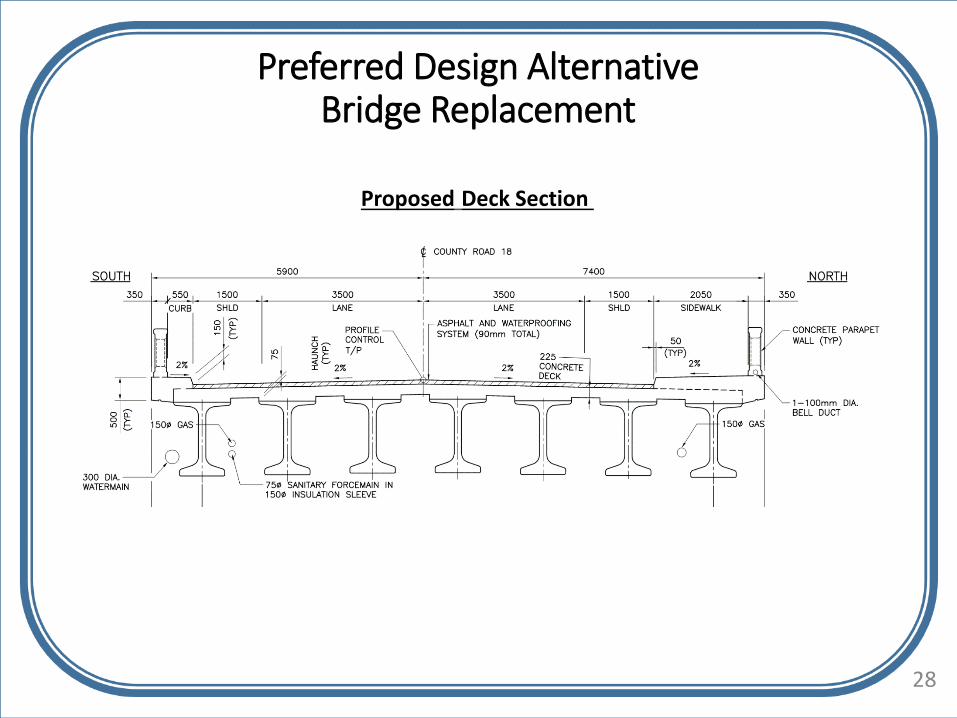
Alternative 3:Replace the Bridge
• The existing bridge would be removed
• The abutments would be relocated to improve hydraulics below the bridge and minimize the removal requirements for the existing foundations.
• Proposed replacement structure would be designed to minimize future maintenance costs (no expansion joints or exposed structural steel to be re-coated)
• A full replacement would have an anticipated lifespan of approximately 75 years.
Replacement addresses the structural and functional deficiencies and has the potential to improve wildlife passage.
This alternative is selected as the preliminary preferred alternative solution.
Removal and replacement of the Salem Bridge is the preferred alternative.
Preferred Design AlternativeBridge Replacement
Proposed Deck Section
28

Preferred Design AlternativeBridge Replacement
Proposed Elevation
29

Detour Route for Salem Bridge Closure
30

Following this PIC period we will:
• Collect and respond to public comments
• Compile the Project File
• Publish a Notice of Study Completion in June 2018
• 30 day review period of the Project File
• Proceed to Phase 5, Implementation with the technically preferred alternative
• Commence detailed design in August 2018
How can you remain involved in the Study?
• Request that your name/e-mail be added to the mailing list
• Provide a completed comment sheet
• Contact the County or the Consultant at any time
For assistance with the above activities, please contact The County ofWellington Engineering Services Department, Roads Division at:
Thank you for your participation in this study. Your input is valuableand appreciated. If you have any questions or comments regardingthis study or the contents of these PIC displays, you are encouragedto submit them to the Project Team by June 13th, 2018. Please referto the County’s website or the “Welcome” slide of these PIC displaysfor contact details. All information is collected in accordance with theFreedom of Information and Privacy Act.
Schedule / Next Steps
Mr. Mark Eby, P. Eng.,Construction ManagerCounty of WellingtonAdministration Centre74 Woolwich StreetGuelph ON N1H 3T9T 800.663.0750 x 2270F 519.837.8138E [email protected]
Carey HutchinsonEngineering Services ClerkCounty of WellingtonAdministration Centre74 Woolwich StreetGuelph ON N1H 3T9T 800.663.0750 x 2210F 519.837.8138E [email protected]
31