roadway license of occupation management plan
TRANSCRIPT
October 2020 Roadway License Management Plan
FILE #
LICENSE #
TRACKING # 100325390
DATE: October 17, 2020
ACCEPTED BY:
SIGNED on behalf of HER MAJESTY THE QUEEN IN THE RIGHT OF THE PROVINCE OF BRITISH COLUMBIA by Crown land Adjudication, Ministry of Forests, Lands, Natural Resource Operations and Rural Development, authorized representative of the minister responsible for the Land Act.
The signature of the Province’s authorized representative is solely for the purpose of acknowledging the Province’s acceptance of this document as the Tenure Management Plan for the purposes of the Licenses and does not represent a certification by the Province or its signatory of any factual content of acceptance of professional responsibility by the Province’s signatory for any advice or analysis contained in this document.
____________________________ ______________________________ Authorized Signature Print Name Crown Land Adjudication Ministry of Forests, Lands, Natural Resource Operations and Rural Development
____________________________ _____________________________Authorized Signature Print Name Powder Renegade Lodge Inc
Contains pages (including this page)
Powder Renegade Lodge Inc 1
ROADWAY LICENSE OF OCCUPATION
MANAGEMENT PLAN
October 2020 Roadway License Management Plan
TABLE OF CONTENTS
1.0 INTRODUCTION ………………………………………………………………………………..…………….. 3 1.1 Project Overview ……………….………………….…………..………………….………..…..….. 31.2 Proponent ………………………………………………………………….…………………………4
1.2.1 Corporate Summary …………………………….………..…….……….….…………42.0 GENERAL ROAD AND TERRAIN DESCRIPTION ………………….….………………………….….….. 5
2.1 Method of Construction …………………………………………………………………………….52.1.1 Cut & Fill Slopes …………………………………………………………………….…72.1.2 Construction Schedule ………………………………………………………………. 72.1.3 Endhaul/Disposal and Borrow Areas ………………………………………………..7
2.2 Seasonal Use and Volume………………………………………………………………………… 73.0 INFRASTRUCTURE & LOCATION …………………………………………………………………………. 8
3.1 Main Access Road ………………………………………………………………………………….8 3.2 Snow Trail Connectivity Roads …………………………………………………………………..10
4.0 ENVIRONMENTAL ….………………………………………………………………………..……….…….. 34 4.1 Stream Crossings …………………………………………………………………….……………34
4.1.1 Ford Design & Construction on Non-Fish Streams …………………………….. 34 4.2 Timber Removal Requirements ………………………………………………………………… 36
4.2.1 Whitebark Pine ………………………………………………………………………36 4.2.2 Old Growth Management Areas ………………………………………………….. 37
4.3 Soil Erosion and Invasive Species ……………………………………………………………….37 4.4 Drainage Control Measures ………………………………………………………………………38 4.5 Wildlife and Sensitive Habitats …………………………………………………………………..38
4.5.1 Grizzly Bear …………………………………………………………………………..385.0 ROAD INSPECTION & MAINTENANCE ………………………………………………………………… 396.0 IMPACTS ON OTHER USERS …………………………..………………………..……………………….. 397.0 RECLAMATION ……………………………………………………………………………………………….39
Powder Renegade Lodge Inc 2

October 2020 Roadway License Management Plan
1.0 INTRODUCTION
1.1 Project Overview
This Roadway Management Plan has been prepared by Cassandra and Kerry Penney, in support of Powder Renegade Lodge Inc’s (PRL) request for a winter commercial recreation Adventure Tourism tenure. The purpose of this tenure is guided cat skiing with a remote lodge. This License of Occupation for Roadway is supplementary to the Licence of Occupation and Lease application, and PRL is requesting a 30 year term. The proposed tenure encompasses 8,847 ha of Crown land in the Midway Range of the Southern Monashee Mountains, between the Granby and Kettle rivers, 70 kms east of Kelowna, BC.
A well connected road network is a vital component of a cat skiing operation. Although this proposed tenure location already has an established and accessible pre-existing FSR network, some additional excavated roads are necessary to be built in order for the snowcat to have adequate access to the proposed ski terrain within the boundary. In this case, appropriate machinery such as an excavator will be used to create a dirt road that is more level. Below the alpine, some tree removal can also be required to establish these roads.
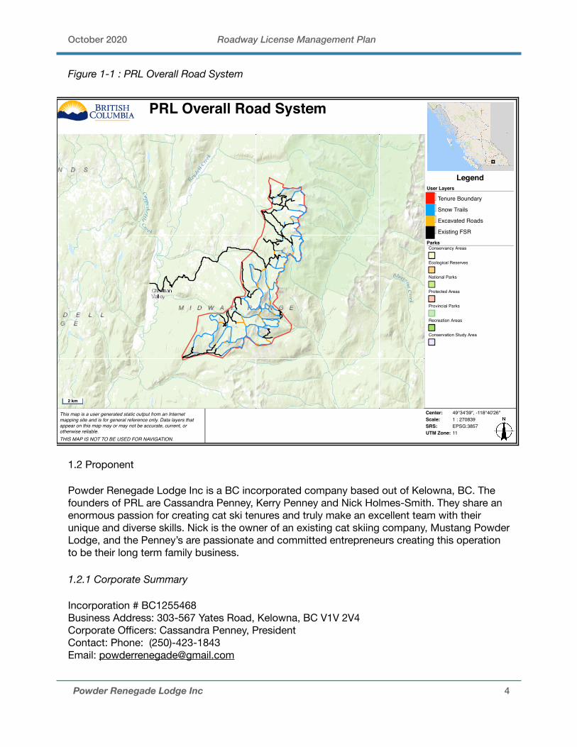
PRL is proposing to use the existing FSR system along with the construction of 10.7 kms of excavated roads and 95 kms of snow trails throughout the proposed boundary to access ski terrain and the lodge site. Excavated roads are defined as permanent tracks that may require some timber removal and necessitates the use of an excavator to construct side cuts into the mineral soils. Snow trails do not necessitate the removal or disturbance of soil, and have therefore been excluded from this Roadway Management Plan. See Figure 1-1: PRL Overall Road System for the entire proposed road and trail system.
The majority of the excavated roads proposed by PRL are connected to snow trails rather than FSR’s. Only 4 of these proposed roads are directly connected to existing FSR’s. This decreases the likelihood of public access or use because it eliminates road access being established to higher alpine areas (the snow trails melt in the spring and summer, so the excavated road segments will be inaccessible without snow). These roads are for the sole purpose of PRL’s cat skiing operation and have been proposed only where necessary throughout the tenure. This plan has been developed using desktop research, mapping and aerial imagery. Various terrain stability and other variables have been considered in this management plan. PRL will follow procedures and recommendations for the variable terrain requirements when building these roads described by the Forest Road Engineering Guidebook.
All maps included in this management plan are available in KML and digital spatial files upon request. A separate management plan for the Lease for an Intensive Use Site and License of Occupation for Extensive Use Area has been prepared and will form part of this tenure.
The proposed roads will not be upgraded to the Ministry of Transportation standards, and a gazette plan of the Right of Way will not be prepared for this project. The roads in this plan will have a minimum life expectancy to match the license term of 30 years.
Powder Renegade Lodge Inc 3
October 2020 Roadway License Management Plan
Figure 1-1 : PRL Overall Road System
1.2 Proponent
Powder Renegade Lodge Inc is a BC incorporated company based out of Kelowna, BC. The founders of PRL are Cassandra Penney, Kerry Penney and Nick Holmes-Smith. They share an enormous passion for creating cat ski tenures and truly make an excellent team with their unique and diverse skills. Nick is the owner of an existing cat skiing company, Mustang Powder Lodge, and the Penney’s are passionate and committed entrepreneurs creating this operation to be their long term family business.
1.2.1 Corporate Summary
Incorporation # BC1255468Business Address: 303-567 Yates Road, Kelowna, BC V1V 2V4Corporate Officers: Cassandra Penney, PresidentContact: Phone: (250)-423-1843Email: [email protected]
Powder Renegade Lodge Inc 4
This map is a user generated static output from an Internetmapping site and is for general reference only. Data layers thatappear on this map may or may not be accurate, current, orotherwise reliable. THIS MAP IS NOT TO BE USED FOR NAVIGATION.
Center: 49°34'39", -118°40'26"Scale: 1 : 270839SRS: EPSG:3857UTM Zone: 11
LegendUser Layers
Tenure Boundary
Snow Trails
Excavated Roads
Existing FSR
ParksConservancy Areas
Ecological Reserves
National Parks
Protected Areas
Provincial Parks
Recreation Areas
Conservation Study Area
PRL Overall Road System
2 km

October 2020 Roadway License Management Plan
2.0 GENERAL ROAD AND TERRAIN DESCRIPTION
2.1 Method of Construction
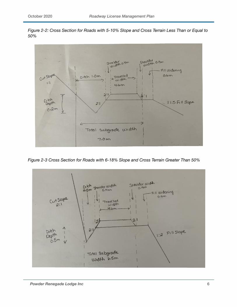
Roads will be constructed by conventional cut and fill techniques with shift into 3/4 bench and full bench cut through steeper sections. Considerations such as terrain stability, local fill, landslide risk and road compatibility with existing terrain slopes will be considered for each excavated road. Clearing widths will be between 5-7m, with ditching depths will be between 0.2-0.5m.The road running widths will be constructed between 4-5m, with shoulders being 0.4m on each side of the road. The total sub grade widths range from 6-7m including ditching, running road and road shoulders.
Measures such as down-sloping the road bench and installing water bars will be utilized at certain points along the road to shed water from the road surface and reduce surface erosion. Fill and minimal road surfacing will be sourced from local fill and debris related to the construction of the roads. The terrain is variable and rugged, with existing land cover predominantly forest with some grasslands, barren and shrubs.
The roads will cross variable terrain with slope gradients of mainly 53-68%. Some roads will cross steeper slopes to as much as 70-86%, and some more gradual slopes between 26%-50%. Rock blasting is not required for the construction of these roads.
The proposed roads have a range in slope between 5-18% and encounter variable cross terrain slopes ranging from 26% to 86%. PRL has prepared two cross sectional diagrams to reflect road construction.
Powder Renegade Lodge Inc 5
Forest Road Engineering Guidebook
15
Clearing width (see Appendix 5)
Top of cut Toe of fill
Road prism
Roadsubgrade
width
Slash and debrispulled back onto
fill slope
3 m*
* Default distance fromtables in Appendix 5(distance may be less)
Stableangle
Figure 2. Typical roadway on moderate slopes with no additional clearing.
October 2020 Roadway License Management Plan
Figure 2-2: Cross Section for Roads with 5-10% Slope and Cross Terrain Less Than or Equal to 50%
Figure 2-3 Cross Section for Roads with 6-18% Slope and Cross Terrain Greater Than 50%
Powder Renegade Lodge Inc 6

October 2020 Roadway License Management Plan
2.1.1 Cut & Fill Slopes
The design of cut slopes will consider and address factors such as types of cut slope materials, overall terrain stability, properties of soils, seepage conditions, construction methods, and maintenance. Cut slopes generally remain stable at slightly steeper angles than fill slopes constructed from like soil materials because undisturbed soil materials in a cut are often in a denser state than similar type materials placed in a fill, and may contain sources of cohesive strength that further increases the shearing resistance of the soil.
The stability of a fill slope depends on several variables, including the forces that tend to cause instability (gravitational and water pressure forces), and the forces that tend to oppose instability (e.g., shear strength resistance of the soil or rock materials expressed as an internal friction angle or cohesion). To ensure stability for fill slopes, flatter side slopes in all types of soil will reduce the gravitational forces that tend to cause slope instability. The fill materials will be compacted to make them more dense and increase the shearing resistance of the soil.
Furthermore, PRL understands the angle of internal friction depends primarily on the relative density (loose versus dense), the particle shape (round versus angular), and the gradation (uniformly graded versus well graded). Good drainage of fill will be employed where necessary to reduce the build-up of water pressure forces along potential planes of sliding within the fill.
2.1.2 Construction Schedule
Road building will occur when snow is still present so that equipment can access these locations using snow trails. Dirt works will only be completed on required sections, thus eliminating any road being created connecting existing FSR’s with the alpine roads. This eliminates potentially new access for all terrain vehicles (ATVs) to the alpine.
2.1.3 Endhaul/Disposal and Borrow Areas
PRL does not anticipate substantial end haul, as most roads will be able to use the debris to build into our roads. Where debris or other unsuitable material cannot be disposed of outside the road prism or within the clearing width, PRL will end haul this to a suitable disposal site for debris. Endhaul debris from the road corridor can occur in steep or unstable terrain where this material is removed to maintain slope stability.
PRL will identify all disposal sites for debris before construction and ensure that approved disposal site(s) for debris is stable, well drained, and isolated from streams or wet sites; and does not have a material adverse effect on forest resources and other values. Debris will be piled and placed to maintain slope stability at all times and will take measures to control erosion and sediment transport.
PRL will dispose of the debris endhauled to an approved disposal site by piling and burning, scattering, or burying. Whichever disposal method is used, PRL will ensure that the top of any remaining debris material is below the road surface (to allow for snowplowing and sight distance) and placed in a manner to allow surface water to drain away from the road.
2.1.4 Seasonal Use and Volume
PRL’s operational period will be from early December to early April. PRL is not requesting any summer activities, and will not be proposing any future applications for summer activities. The
Powder Renegade Lodge Inc 7

October 2020 Roadway License Management Plan
main lodge access road will be the highest traffic road out of all of the proposed roads in the tenure because of its nature being access to the lodge site. Use of these roads will be very light respective to existing in nature and will be respective to needs of the lodge and operation.
3.0 INFRASTRUCTURE & LOCATION
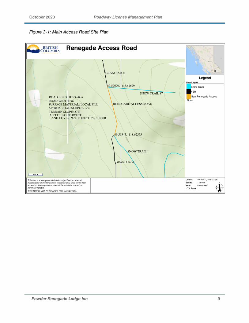
3.1 Main Access Road
Commencing at the 51km marker on the Christian Valley road is the Grano Creek FSR, which the entrance to the proposed tenure and main access road. Continue on this road 14.2 kms, staying right onto Charlie Road FSR road for 1.1 kms, and then stay right onto Noren FSR for 4.3 kms, which climbs a southwest aspect hillside. Stay right again on Grano 14640 which continues climbing and ends at 1900 m elevation. An excavated road 374 m long is required to connect to Grano 22830, at 1960 m elevation. This road is located in Zone 3.
The road will cross variable terrain with slopes gradients of mainly 57%, and will necessitate the removal of trees. Planned use for the road is primarily for access to the Powder Renegade Lodge. This will include 4x4 pickups during snow free months, fuel trucks for a short window (2-3 weeks) during the late summer/fall and infrequent 5 tonne supply trucks. There will be no snow removal during winter other than minor plowing during early spring to get the road open and winter traffic will be restricted to snow cats and snowmobiles.
An approximately 0.3m deep ditch line will run for the length of the road and water bars will be installed throughout the road as necessary. Cross ditches and water bars may be infilled for short periods of time (2-3 weeks) when fuel trucks are required for fuel delivery.
Powder Renegade Lodge Inc 8
October 2020 Roadway License Management Plan
Figure 3-1: Main Access Road Site Plan
Powder Renegade Lodge Inc 9
This map is a user generated static output from an Internetmapping site and is for general reference only. Data layers thatappear on this map may or may not be accurate, current, orotherwise reliable. THIS MAP IS NOT TO BE USED FOR NAVIGATION.
Center: 49°35'41", -118°37'35"Scale: 1 : 8464SRS: EPSG:3857UTM Zone: 11
LegendUser Layers
Snow Trails
FSR
New Renegade AccessRoad
Renegade Access Road
SNOW TRAIL 87
49.59345, -118.62555
RENEGADE ACCESS ROAD
49.59670, -118.62629
SNOW TRAIL 1
GRANO 22830
GRANO 14640
ROAD LENGTH:0.374kmROAD WIDTH:6mSURFACE MATERIAL: LOCAL FILLAPPROX ROAD SLOPE:6-12%TERRAIN SLOPE: 57%ASPECT: SOUTHWESTLAND COVER: 92% FOREST, 8% SHRUB
100 m
October 2020 Roadway License Management Plan
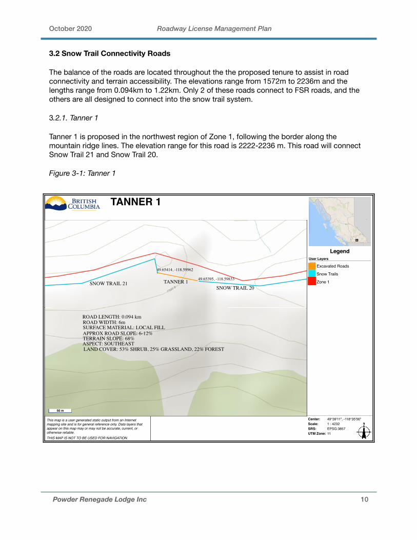
3.2 Snow Trail Connectivity Roads
The balance of the roads are located throughout the the proposed tenure to assist in road connectivity and terrain accessibility. The elevations range from 1572m to 2236m and the lengths range from 0.094km to 1.22km. Only 2 of these roads connect to FSR roads, and the others are all designed to connect into the snow trail system.
3.2.1. Tanner 1
Tanner 1 is proposed in the northwest region of Zone 1, following the border along the mountain ridge lines. The elevation range for this road is 2222-2236 m. This road will connect Snow Trail 21 and Snow Trail 20.
Figure 3-1: Tanner 1
Powder Renegade Lodge Inc 10
This map is a user generated static output from an Internetmapping site and is for general reference only. Data layers thatappear on this map may or may not be accurate, current, orotherwise reliable. THIS MAP IS NOT TO BE USED FOR NAVIGATION.
Center: 49°39'11", -118°35'56"Scale: 1 : 4232SRS: EPSG:3857UTM Zone: 11
LegendUser Layers
Excavated Roads
Snow Trails
Zone 1
TANNER 1
SNOW TRAIL 21SNOW TRAIL 20
49.65414, -118.59962
49.65395, -118.59833
ROAD LENGTH: 0.094 kmROAD WIDTH: 6mSURFACE MATERIAL: LOCAL FILL
TANNER 1
APPROX ROAD SLOPE: 6-12%TERRAIN SLOPE: 68%ASPECT: SOUTHEASTLAND COVER: 53% SHRUB, 25% GRASSLAND, 22% FOREST
50 m
October 2020 Roadway License Management Plan
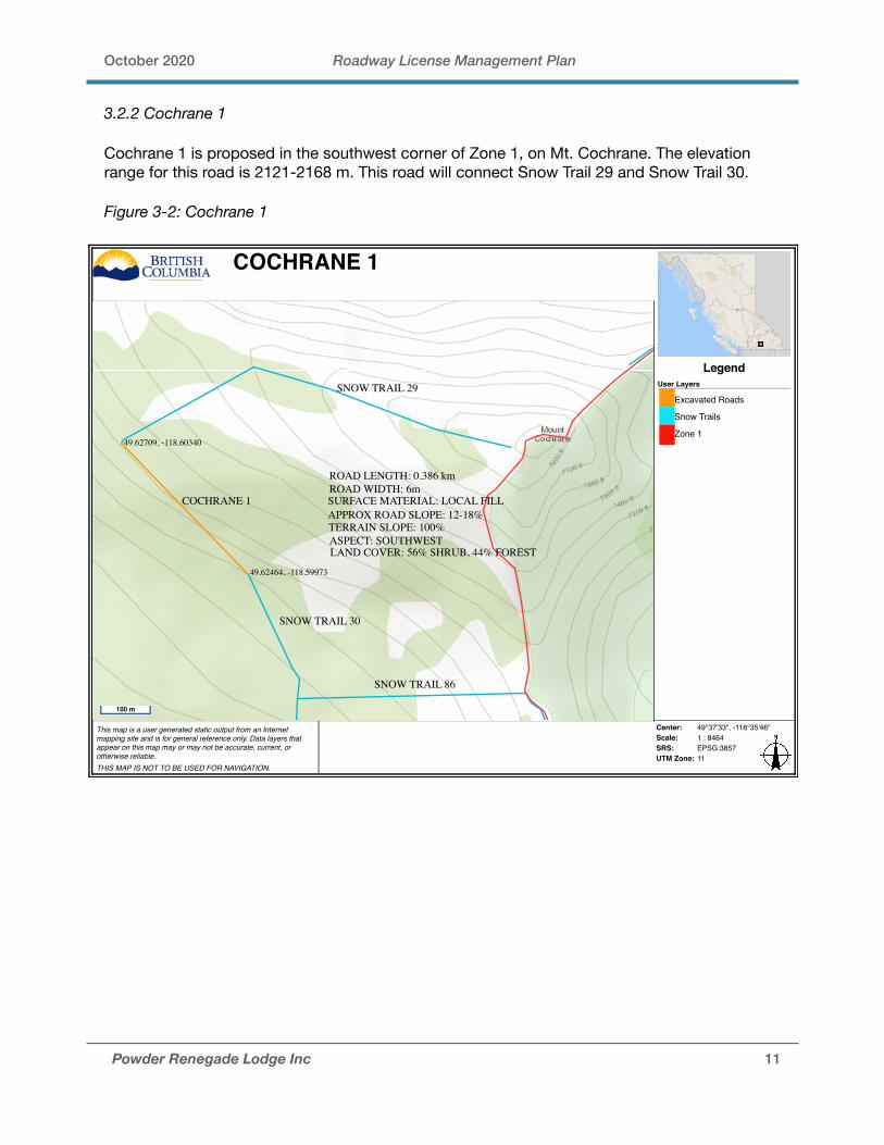
3.2.2 Cochrane 1
Cochrane 1 is proposed in the southwest corner of Zone 1, on Mt. Cochrane. The elevation range for this road is 2121-2168 m. This road will connect Snow Trail 29 and Snow Trail 30.
Figure 3-2: Cochrane 1
Powder Renegade Lodge Inc 11
This map is a user generated static output from an Internetmapping site and is for general reference only. Data layers thatappear on this map may or may not be accurate, current, orotherwise reliable. THIS MAP IS NOT TO BE USED FOR NAVIGATION.
Center: 49°37'33", -118°35'46"Scale: 1 : 8464SRS: EPSG:3857UTM Zone: 11
LegendUser Layers
Excavated Roads
Snow Trails
Zone 1
COCHRANE 1
ROAD LENGTH: 0.386 kmROAD WIDTH: 6mSURFACE MATERIAL: LOCAL FILLAPPROX ROAD SLOPE: 12-18%TERRAIN SLOPE: 100%ASPECT: SOUTHWESTLAND COVER: 56% SHRUB, 44% FOREST
49.62709, -118.60340
49.62464, -118.59973
SNOW TRAIL 29
COCHRANE 1
SNOW TRAIL 30
SNOW TRAIL 86
100 m
October 2020 Roadway License Management Plan
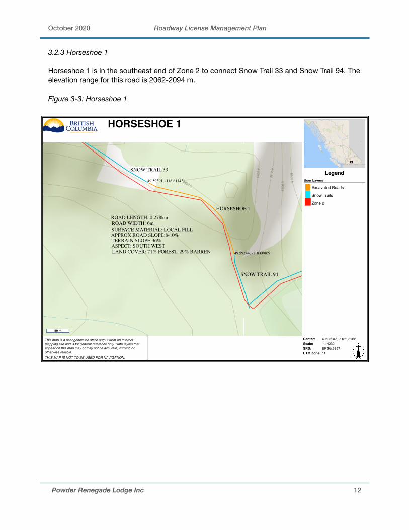
3.2.3 Horseshoe 1
Horseshoe 1 is in the southeast end of Zone 2 to connect Snow Trail 33 and Snow Trail 94. The elevation range for this road is 2062-2094 m.
Figure 3-3: Horseshoe 1
Powder Renegade Lodge Inc 12
This map is a user generated static output from an Internetmapping site and is for general reference only. Data layers thatappear on this map may or may not be accurate, current, orotherwise reliable. THIS MAP IS NOT TO BE USED FOR NAVIGATION.
Center: 49°35'34", -118°36'38"Scale: 1 : 4232SRS: EPSG:3857UTM Zone: 11
LegendUser Layers
Excavated Roads
Snow Trails
Zone 2
HORSESHOE 1
HORSESHOE 1
SNOW TRAIL 94
SNOW TRAIL 33
49.59391, -118.61143
49.59244, -118.60869
ROAD LENGTH: 0.278kmROAD WIDTH: 6mSURFACE MATERIAL: LOCAL FILLAPPROX ROAD SLOPE:8-10%TERRAIN SLOPE:36%ASPECT: SOUTH WESTLAND COVER: 71% FOREST, 29% BARREN
50 m
October 2020 Roadway License Management Plan
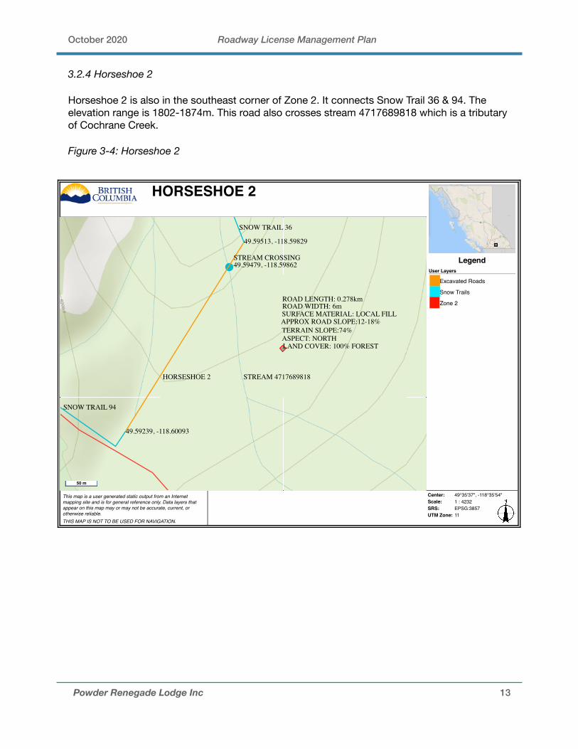
3.2.4 Horseshoe 2
Horseshoe 2 is also in the southeast corner of Zone 2. It connects Snow Trail 36 & 94. The elevation range is 1802-1874m. This road also crosses stream 4717689818 which is a tributary of Cochrane Creek.
Figure 3-4: Horseshoe 2
Powder Renegade Lodge Inc 13
This map is a user generated static output from an Internetmapping site and is for general reference only. Data layers thatappear on this map may or may not be accurate, current, orotherwise reliable. THIS MAP IS NOT TO BE USED FOR NAVIGATION.
Center: 49°35'37", -118°35'54"Scale: 1 : 4232SRS: EPSG:3857UTM Zone: 11
LegendUser Layers
Excavated Roads
Snow Trails
Zone 2
HORSESHOE 2
ROAD LENGTH: 0.278kmROAD WIDTH: 6mSURFACE MATERIAL: LOCAL FILLAPPROX ROAD SLOPE:12-18%TERRAIN SLOPE:74%ASPECT: NORTHLAND COVER: 100% FOREST
HORSESHOE 2
49.59513, -118.59829
49.59239, -118.60093
STREAM CROSSING49.59479, -118.59862
STREAM 4717689818
SNOW TRAIL 36
SNOW TRAIL 94
50 m
October 2020 Roadway License Management Plan
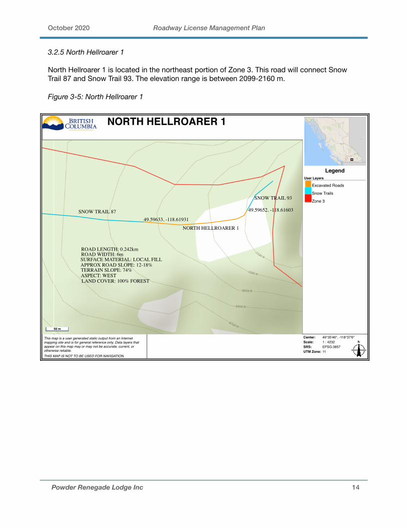
3.2.5 North Hellroarer 1
North Hellroarer 1 is located in the northeast portion of Zone 3. This road will connect Snow Trail 87 and Snow Trail 93. The elevation range is between 2099-2160 m.
Figure 3-5: North Hellroarer 1
Powder Renegade Lodge Inc 14
This map is a user generated static output from an Internetmapping site and is for general reference only. Data layers thatappear on this map may or may not be accurate, current, orotherwise reliable. THIS MAP IS NOT TO BE USED FOR NAVIGATION.
Center: 49°35'46", -118°37'6"Scale: 1 : 4232SRS: EPSG:3857UTM Zone: 11
LegendUser Layers
Excavated Roads
Snow Trails
Zone 3
NORTH HELLROARER 1
49.59652, -118.61603
49.59633, -118.61931
SNOW TRAIL 93
SNOW TRAIL 87
NORTH HELLROARER 1
ROAD LENGTH: 0.242kmROAD WIDTH: 6mSURFACE MATERIAL: LOCAL FILLAPPROX ROAD SLOPE: 12-18%TERRAIN SLOPE: 74%ASPECT: WESTLAND COVER: 100% FOREST
50 m

October 2020 Roadway License Management Plan
3.2.6 North Hellroarer 2
North Hellroarer 2 is located by the eastern tenure border in Zone 3. This road will create a junction point for the road system, connecting between Snow Trail 38 and Snow Trail 93. The elevation range is between 2017-2102 m.
Figure 3-6: North Hellroarer 2
Powder Renegade Lodge Inc 15
This map is a user generated static output from an Internetmapping site and is for general reference only. Data layers thatappear on this map may or may not be accurate, current, orotherwise reliable. THIS MAP IS NOT TO BE USED FOR NAVIGATION.
Center: 49°34'48", -118°36'52"Scale: 1 : 4232SRS: EPSG:3857UTM Zone: 11
LegendUser Layers
Excavated Roads
Snow Trails
Zone 3
NORTH HELLROARER 2
SNOW TRAIL 39
SNOW TRAIL 38
NORTH HELLROARER 249.58088, -118.61501
49.58000, -118.61211ROAD LENGTH: 0.235KMROAD WIDTH: 6mSURFACE MATERIAL: LOCAL FILLAPPROX ROAD SLOPE: 6-12%TERRAIN SLOPE: 61%ASPECT: WESTLAND COVER: 100% FOREST
50 m

October 2020 Roadway License Management Plan
3.2.7 North Hellroarer 3
North Hellroarer 3 follows the eastern tenure border in Zone 3. This road will create connectivity for the road system following the mountain top of an unnamed mountain, connecting between Snow Trail 38 and Snow Trail 50. The elevation range is between 2127-2151 m.
Figure 3-7: North Hellroarer 3
Powder Renegade Lodge Inc 16
This map is a user generated static output from an Internetmapping site and is for general reference only. Data layers thatappear on this map may or may not be accurate, current, orotherwise reliable. THIS MAP IS NOT TO BE USED FOR NAVIGATION.
Center: 49°35'4", -118°36'45"Scale: 1 : 4232SRS: EPSG:3857UTM Zone: 11
LegendUser Layers
Excavated Roads
Snow Trails
Zone 3
NORTH HELLROARER 3
49.58511, -118.61057
49.58408, -118.61165
NORTH HELLROARER 3
SNOW TRAIL 38
SNOW TRAIL 50
ROAD LENGTH:0.155KMROAD WIDTH: 6mSURFACE MATERIAL: LOCAL FILLAPPROX ROAD SLOPE: 6-12%TERRAIN SLOPE: 47%ASPECT: NORTHWESTLAND COVER: 100% FOREST
50 m

October 2020 Roadway License Management Plan
3.2.8 North Hellroarer 4
North Hellroarer 4 follows the eastern tenure border in Zone 3, and is located south of North Hellroarer 3. This road will create connectivity for the road system going up an unnamed mountain where the terrain is unsuitable for a snow trail. It will connect between Snow Trail 38 and Snow Trail 50. The elevation range is between 2093 - 2132m.
3.2.9 North Hellroarer 5
North Hellroarer 5 follows the eastern tenure border in Zone 3, and is located south of North Hellroarer 4. This road will create connectivity for the road system between two mountains (unnamed mountains), connecting between Snow Trail 53 and Snow Trail 65. The elevation range is between 2121-2164 m.
Figure 3-8: North Hellroarer 4&5
Powder Renegade Lodge Inc 17
This map is a user generated static output from an Internetmapping site and is for general reference only. Data layers thatappear on this map may or may not be accurate, current, orotherwise reliable. THIS MAP IS NOT TO BE USED FOR NAVIGATION.
Center: 49°34'32", -118°37'7"Scale: 1 : 4232SRS: EPSG:3857UTM Zone: 11
LegendUser Layers
Excavated Roads
Snow Trails
Zone 3
NORTH HELLROARER 4&5
49.57713, -118.61761
49.57686, -118.61887
49.57550, -118.61954
49.57389, -118.61985
NORTH HELLROARER 4
NORTH HELLROARER 5
SNOW TRAIL 53
SNOW TRAIL 50
NORTH HELLROARER 4:ROAD LENGTH:0.94kmROAD WIDTH: 6mSURFACE MATERIAL: LOCAL FILLAPPROX ROAD SLOPE: 6-12%TERRAIN SLOPE: 35%ASPECT: NORTHLAND COVER: 100% FOREST
NORTH HELLROARER 5:ROAD LENGTH:0.181KMROAD WIDTH: 6mSURFACE MATERIAL: LOCAL FILLAPPROX ROAD SLOPE: 6-12%TERRAIN SLOPE:54%ASPECT: NORTHWESTLAND COVER: 100% FOREST
50 m

October 2020 Roadway License Management Plan
3.2.10 North Hellroarer 6
North Hellroarer 6 is in the mid-eastern portion of Zone 3. It will connect Snow Trail 84 to the upper elevation bordering the tenure boundary, connecting into Snow Trail 92 which follows the mountain ridge lines (unnamed mountains) at the upper elevation. The elevation range is between 2053-2083 m.
3.2.11 North Hellroarer 7
North Hellroarer 7 is south of North Hellroarer 6 and follows the tenure boundary connecting to the top of an unnamed mountain. It will connect Snow Trail 92 to Snow Trail. The elevation range is between 2098-2152 m.
Figure 3-9: North Hellroarer 6&7
Powder Renegade Lodge Inc 18
This map is a user generated static output from an Internetmapping site and is for general reference only. Data layers thatappear on this map may or may not be accurate, current, orotherwise reliable. THIS MAP IS NOT TO BE USED FOR NAVIGATION.
Center: 49°33'58", -118°37'24"Scale: 1 : 4232SRS: EPSG:3857UTM Zone: 11
LegendUser Layers
Excavated Roads
Snow Trails
Zone 3
NORTH HELLROARER 6&7
NORTH HELLROARER 6
NORTH HELLROARER 7
SNOW TRAIL 92SNOW TRAIL 84
49.56764, -118.62260
49.56643, -118.62422
49.56607, -118.62295
49.56463, -118.62311
SNOW TRAIL 6
NORTH HELLROARER 6:ROAD LENGTH:0.18kmROAD WIDTH: 6m
NORTH HELLROARER 7:
SURFACE MATERIAL: LOCAL FILLAPPROX ROAD SLOPE:6-12%
TERRAIN SLOPE: 59%ASPECT: NORTHWEST
LAND COVER: 100% FORESTROAD LENGTH:0.166kmROAD WIDTH:6mSURFACE MATERIAL: LOCAL FILLAPPROX ROAD SLOPE:6-12%TERRAIN SLOPE: 38%ASPECT: NORTHWESTLAND COVER: 100% FOREST
50 m

October 2020 Roadway License Management Plan
3.2.12 North Hellroarer 8
North Hellroarer 8 stems off of Snow Trail 66 and crosses the southern border of Zone 3 to connects with South Hellroarer 2 in Zone 4. This road has a stream crossing over stream 471690317. The elevation range is between 1773 m-1780.
Figure 3-10: North Hellroarer 8
Powder Renegade Lodge Inc 19
This map is a user generated static output from an Internetmapping site and is for general reference only. Data layers thatappear on this map may or may not be accurate, current, orotherwise reliable. THIS MAP IS NOT TO BE USED FOR NAVIGATION.
Center: 49°33'2", -118°37'47"Scale: 1 : 4232SRS: EPSG:3857UTM Zone: 11
LegendUser Layers
Excavated Roads
Snow Trails
Zone 3
NORTH HELLROARER 8
NORTH HELLROARER 8
SNOW TRAIL 66
49.54995, -118.63192
49.54885, -118.63169
STREAM CROSSING49.54972, -118.63184
STREAM 471690317
ROAD LENGTH:0.120kmROAD WIDTH: 6m
SURFACE MATERIAL: LOCAL FILLAPPROX ROAD SLOPE:6-12%TERRAIN SLOPE: 50%ASPECT: EASTLAND COVER: 84% FOREST, 16% SHRUB
50 m
October 2020 Roadway License Management Plan
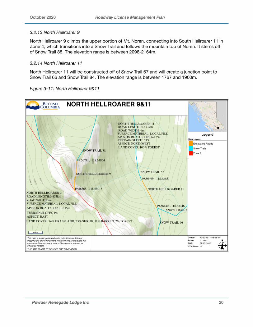
3.2.13 North Hellroarer 9
North Hellroarer 9 climbs the upper portion of Mt. Noren, connecting into South Hellroarer 11 in Zone 4, which transitions into a Snow Trail and follows the mountain top of Noren. It stems off of Snow Trail 88. The elevation range is between 2098-2164m.
3.2.14 North Hellroarer 11
North Hellroarer 11 will be constructed off of Snow Trail 67 and will create a junction point to Snow Trail 66 and Snow Trail 84. The elevation range is between 1767 and 1900m.
Figure 3-11: North Hellroarer 9&11
Powder Renegade Lodge Inc 20
This map is a user generated static output from an Internetmapping site and is for general reference only. Data layers thatappear on this map may or may not be accurate, current, orotherwise reliable. THIS MAP IS NOT TO BE USED FOR NAVIGATION.
Center: 49°33'56", -118°38'37"Scale: 1 : 16927SRS: EPSG:3857UTM Zone: 11
LegendUser Layers
Excavated Roads
Snow Trails
Zone 3
NORTH HELLROARER 9&11
NORTH HELLROARER 9
NORTH HELLROARER 11
49.56741, -118.64964
49.56365, -118.65015
SNOW TRAIL 88
SNOW TRAIL 67
SNOW TRAIL 66
SNOW TRAIL 87
49.56499, -118.63651
49.56140, -118.63346
NORTH HELLROARER 9:ROAD LENGTH:0.455kmROAD WIDTH: 6mSURFACE MATERIAL: LOCAL FILLAPPROX ROAD SLOPE:10-15%TERRAIN SLOPE:74%ASPECT: EASTLAND COVER: 54% GRASSLAND, 33% SHRUB, 11% BARREN, 2% FOREST
NORTH HELLROARER 11:ROAD LENGTH:0.473kmROAD WIDTH: 6m
SURFACE MATERIAL: LOCAL FILLAPPROX ROAD SLOPE:6-12%TERRAIN SLOPE: 53%ASPECT: NORTHWESTLAND COVER:100% FOREST
200 m
October 2020 Roadway License Management Plan
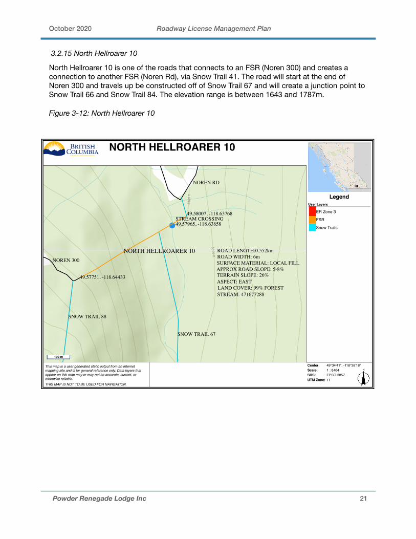
3.2.15 North Hellroarer 10
North Hellroarer 10 is one of the roads that connects to an FSR (Noren 300) and creates a connection to another FSR (Noren Rd), via Snow Trail 41. The road will start at the end of Noren 300 and travels up be constructed off of Snow Trail 67 and will create a junction point to Snow Trail 66 and Snow Trail 84. The elevation range is between 1643 and 1787m.
Figure 3-12: North Hellroarer 10
Powder Renegade Lodge Inc 21
This map is a user generated static output from an Internetmapping site and is for general reference only. Data layers thatappear on this map may or may not be accurate, current, orotherwise reliable. THIS MAP IS NOT TO BE USED FOR NAVIGATION.
Center: 49°34'41", -118°38'18"Scale: 1 : 8464SRS: EPSG:3857UTM Zone: 11
LegendUser Layers
ER Zone 3
FSR
Snow Trails
NORTH HELLROARER 10
STREAM CROSSING49.57965, -118.63858
49.58007, -118.63768
49.57751, -118.64433
NORTH HELLROARER 10
SNOW TRAIL 67
SNOW TRAIL 88
NOREN 300
NOREN RD
ROAD LENGTH:0.552kmROAD WIDTH: 6mSURFACE MATERIAL: LOCAL FILLAPPROX ROAD SLOPE: 5-8%TERRAIN SLOPE: 26%ASPECT: EASTLAND COVER: 99% FORESTSTREAM: 471677288
100 m
October 2020 Roadway License Management Plan
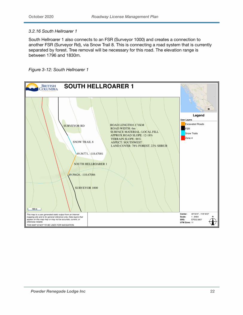
3.2.16 South Hellroarer 1
South Hellroarer 1 also connects to an FSR (Surveyor 1000) and creates a connection to another FSR (Surveyor Rd), via Snow Trail 8. This is connecting a road system that is currently separated by forest. Tree removal will be necessary for this road. The elevation range is between 1796 and 1830m.
Figure 3-12: South Hellroarer 1
Powder Renegade Lodge Inc 22
This map is a user generated static output from an Internetmapping site and is for general reference only. Data layers thatappear on this map may or may not be accurate, current, orotherwise reliable. THIS MAP IS NOT TO BE USED FOR NAVIGATION.
Center: 49°34'4", -118°40'2"Scale: 1 : 8464SRS: EPSG:3857UTM Zone: 11
LegendUser Layers
Excavated Roads
FSR
Snow Trails
Zone 4
SOUTH HELLROARER 1
SOUTH HELLROARER 1
SNOW TRAIL 8
SURVEYOR RD
SURVEYOR 1000
49.56771, -118.67001
49.56626, -118.67086
ROAD LENGTH:0.171KMROAD WIDTH: 6mSURFACE MATERIAL: LOCAL FILLAPPROX ROAD SLOPE: 12-18%TERRAIN SLOPE: 86%ASPECT: SOUTHWESTLAND COVER: 78% FOREST, 22% SHRUB
100 m

October 2020 Roadway License Management Plan
3.2.16 South Hellroarer 2
South Hellroarer 2 will create a junction point between Snow Trail 89 and Snow Trail 59 within Zone 4, and also connects to North Hellroarer 8 in Zone 3. This road features steep cliffy terrain that will also necessitate tree removal. This road crosses stream 471690317 twice. The elevation range is between 1721-1773m.
Figure 3:13 - South Hellroarer 2
Powder Renegade Lodge Inc 23
This map is a user generated static output from an Internetmapping site and is for general reference only. Data layers thatappear on this map may or may not be accurate, current, orotherwise reliable. THIS MAP IS NOT TO BE USED FOR NAVIGATION.
Center: 49°32'50", -118°37'54"Scale: 1 : 4232SRS: EPSG:3857UTM Zone: 11
LegendUser Layers
Excavated Roads
FSR
Snow Trails
Zone 4
SOUTH HELLROARER 2
SOUTH HELLROARER 2
STREAM CROSSING49.54795, -118.63146
STREAM CROSSING49.54698, -118.63114
49.54881, -118.63170
49.54605, -118.63082
SNOW TRAIL 89 SNOW TRAIL 59
ROAD LENGTH:0.319kmROAD WIDTH: 6mSURFACE MATERIAL: LOCAL FILLAPPROX ROAD SLOPE: 8%TERRAIN SLOPE: 67%ASPECT: SOUTHEASTLAND COVER: 84% SHRUB, 16% GRASSLANDSTREAM: 471690317 (x2 crosses)
50 m

October 2020 Roadway License Management Plan
3.2.17 South Hellroarer 3
South Hellroarer 3 is the final road that connects to a FSR (Aviator 1300), and is also the longest of the proposed roads. This road serves as a major connector for this zone, beginning east from Aviator 1300 and traversing south up an unnamed mountain which is quite steep and cliffy to Snow Trail 49. This road also creates the junction point for South Hellroarer 4. The terrain is quite dense in trees so will necessitate tree removal. The elevation range is between 1830-2131m.
3.2.18 South Hellroarer 4
South Hellroarer 4 begins where South Hellroarer 3 pivots south. This road continues north into Snow Trail 47. Again, the land cover is predominantly forest and will necessitate tree removal. The elevation range is between 1822-2033m.
Figure 3-14: South Hellroarer 4
Powder Renegade Lodge Inc 24
This map is a user generated static output from an Internetmapping site and is for general reference only. Data layers thatappear on this map may or may not be accurate, current, orotherwise reliable. THIS MAP IS NOT TO BE USED FOR NAVIGATION.
Printed from the Pre-Application app Center: 49°32'0", -118°40'7"Scale: 1 : 16927SRS: EPSG:3857UTM Zone: 11
LegendUser Layers
Excavated Roads
FSR
Snow Trails
Zone 4
SOUTH HELLROARER 3&4
SOUTH HELLROARER 4
SOUTH HELLROARER 3
SOUTH HELLROARER 3AVIATOR 1300
49.53639, -118.67241
49.53032, -118.66932
49.52664, -118.66696
49.53026, -118.68009
SNOW TRAIL 47
SNOW TRAIL 49
AVIATOR 1200
ROAD LENGTH:0.737kmROAD WIDTH: 6mSURFACE MATERIAL: LOCAL FILL
SOUTH HELLROARER 4:
APPROX ROAD SLOPE:6-10%TERRAIN SLOPE: 48%ASPECT: NORTHLAND COVER: 100% FOREST
NORTH HELLROARER 3:ROAD LENGTH: 1.22kmROAD WIDTH: 6mSURFACE MATERIAL: LOCAL FILLAPPROX ROAD SLOPE:6-12%TERRAIN SLOPE: 61%ASPECT: NORTH/WEST/SOUTHLAND COVER: 99% FOREST, 1% SHRUB
200 m
October 2020 Roadway License Management Plan
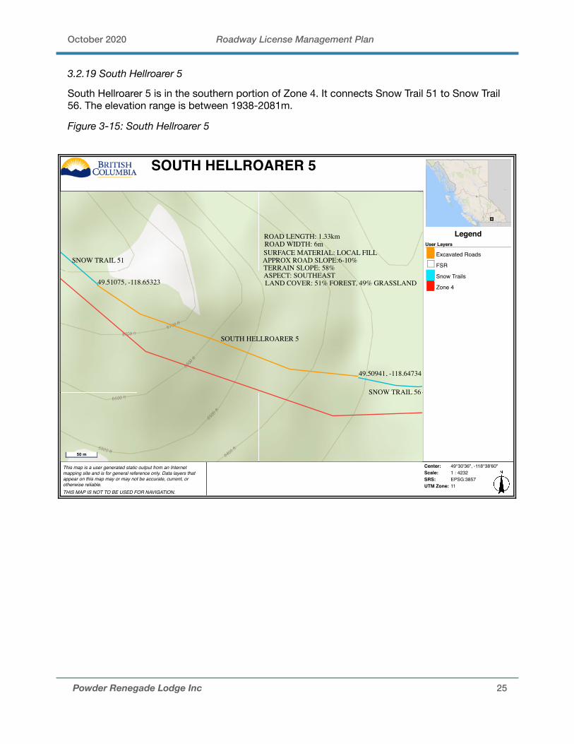
3.2.19 South Hellroarer 5
South Hellroarer 5 is in the southern portion of Zone 4. It connects Snow Trail 51 to Snow Trail 56. The elevation range is between 1938-2081m.
Figure 3-15: South Hellroarer 5
Powder Renegade Lodge Inc 25
This map is a user generated static output from an Internetmapping site and is for general reference only. Data layers thatappear on this map may or may not be accurate, current, orotherwise reliable. THIS MAP IS NOT TO BE USED FOR NAVIGATION.
Center: 49°30'36", -118°38'60"Scale: 1 : 4232SRS: EPSG:3857UTM Zone: 11
LegendUser Layers
Excavated Roads
FSR
Snow Trails
Zone 4
SOUTH HELLROARER 5
SOUTH HELLROARER 5
SNOW TRAIL 51
SNOW TRAIL 56
49.51075, -118.65323
49.50941, -118.64734
ROAD LENGTH: 1.33kmROAD WIDTH: 6mSURFACE MATERIAL: LOCAL FILLAPPROX ROAD SLOPE:6-10%TERRAIN SLOPE: 58%ASPECT: SOUTHEASTLAND COVER: 51% FOREST, 49% GRASSLAND
50 m
October 2020 Roadway License Management Plan
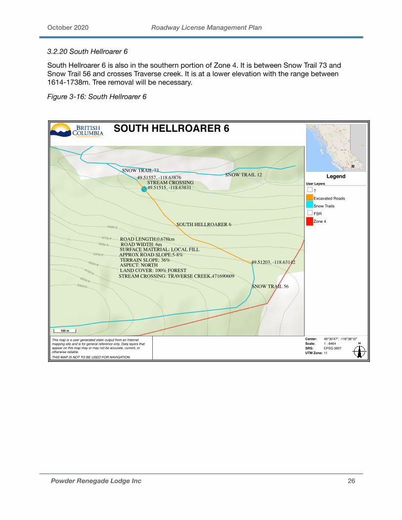
3.2.20 South Hellroarer 6
South Hellroarer 6 is also in the southern portion of Zone 4. It is between Snow Trail 73 and Snow Trail 56 and crosses Traverse creek. It is at a lower elevation with the range between 1614-1738m. Tree removal will be necessary.
Figure 3-16: South Hellroarer 6
Powder Renegade Lodge Inc 26
This map is a user generated static output from an Internetmapping site and is for general reference only. Data layers thatappear on this map may or may not be accurate, current, orotherwise reliable. THIS MAP IS NOT TO BE USED FOR NAVIGATION.
Center: 49°30'47", -118°38'10"Scale: 1 : 8464SRS: EPSG:3857UTM Zone: 11
LegendUser Layers
?
Excavated Roads
Snow Trails
FSR
Zone 4
SOUTH HELLROARER 6
49.51557, -118.63876
49.51203, -118.63142
STREAM CROSSING49.51515, -118.63831
SOUTH HELLROARER 6
SNOW TRAIL 73SNOW TRAIL 12
SNOW TRAIL 56
ROAD LENGTH:0.678kmROAD WIDTH: 6mSURFACE MATERIAL: LOCAL FILLAPPROX ROAD SLOPE:5-8%TERRAIN SLOPE: 36%ASPECT: NORTHLAND COVER: 100% FOREST
STREAM CROSSING: TRAVERSE CREEK,471690609
100 m
October 2020 Roadway License Management Plan
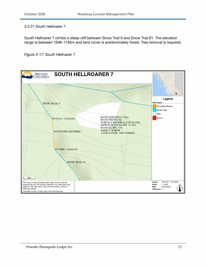
3.2.21 South Hellroarer 7
South Hellroarer 7 climbs a steep cliff between Snow Trail 9 and Snow Trail 91. The elevation range is between 1696-1795m and land cover is predominately forest. Tree removal is required.
Figure 3-17: South Hellroarer 7
Powder Renegade Lodge Inc 27
This map is a user generated static output from an Internetmapping site and is for general reference only. Data layers thatappear on this map may or may not be accurate, current, orotherwise reliable. THIS MAP IS NOT TO BE USED FOR NAVIGATION.
Center: 49°31'54", -118°38'23"Scale: 1 : 4232SRS: EPSG:3857UTM Zone: 11
LegendUser Layers
Excavated Roads
Snow Trails
FSR
Zone 4
SOUTH HELLROARER 7
49.53214, -118.64196
49.53088, -118.64178
SOUTH HELLROARER 7
SNOW TRAIL 9
SNOW TRAIL 91
ROAD LENGTH:0.137kmROAD WIDTH: 6mSURFACE MATERIAL:LOCAL FILLAPPROX ROAD SLOPE: 12-18%ROAD SLOPE: 73%ASPECT: NORTHLAND COVER: 100% FOREST
50 m
October 2020 Roadway License Management Plan
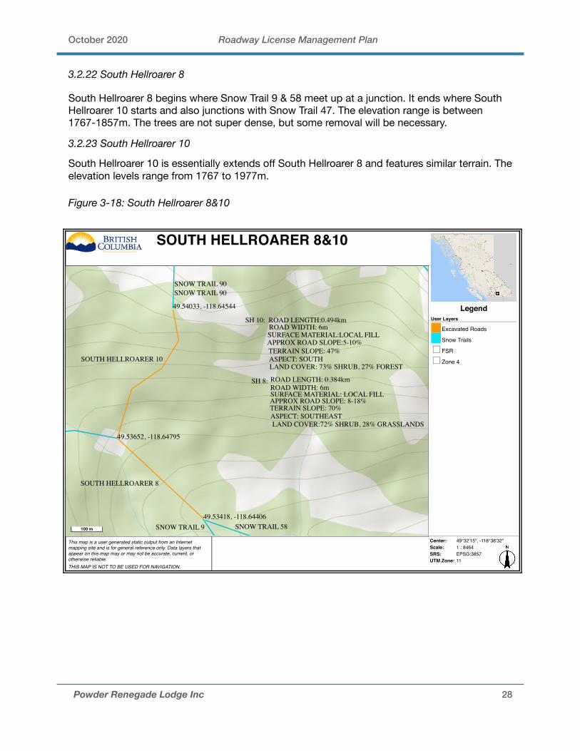
3.2.22 South Hellroarer 8
South Hellroarer 8 begins where Snow Trail 9 & 58 meet up at a junction. It ends where South Hellroarer 10 starts and also junctions with Snow Trail 47. The elevation range is between 1767-1857m. The trees are not super dense, but some removal will be necessary.
3.2.23 South Hellroarer 10
South Hellroarer 10 is essentially extends off South Hellroarer 8 and features similar terrain. The elevation levels range from 1767 to 1977m.
Figure 3-18: South Hellroarer 8&10
Powder Renegade Lodge Inc 28
This map is a user generated static output from an Internetmapping site and is for general reference only. Data layers thatappear on this map may or may not be accurate, current, orotherwise reliable. THIS MAP IS NOT TO BE USED FOR NAVIGATION.
Center: 49°32'15", -118°38'32"Scale: 1 : 8464SRS: EPSG:3857UTM Zone: 11
LegendUser Layers
Excavated Roads
Snow Trails
FSR
Zone 4
SOUTH HELLROARER 8&10
SOUTH HELLROARER 8
49.53652, -118.64795
49.53418, -118.64406
49.54033, -118.64544
SNOW TRAIL 9
SOUTH HELLROARER 10
SNOW TRAIL 90
SH 10: ROAD LENGTH:0.494kmROAD WIDTH: 6mSURFACE MATERIAL:LOCAL FILLAPPROX ROAD SLOPE:5-10%TERRAIN SLOPE: 47%ASPECT: SOUTHLAND COVER: 73% SHRUB, 27% FOREST
SH 8: ROAD LENGTH: 0.384kmROAD WIDTH: 6m
APPROX ROAD SLOPE: 8-18%TERRAIN SLOPE: 70%
SURFACE MATERIAL: LOCAL FILL
ASPECT: SOUTHEASTLAND COVER:72% SHRUB, 28% GRASSLANDS
SNOW TRAIL 90
SNOW TRAIL 58100 m

October 2020 Roadway License Management Plan
3.2.24 South Hellroarer 9
South Hellroarer 9 connects Snow Trail 55 & 68 which climbs an unnamed mountain in the mid-eastern section of the tenure. The elevation range is between 1741-1903m and land cover is mixed between forest and grassland. Some tree removal is required to build this road.
Figure 3-19: South Hellroarer 9
Powder Renegade Lodge Inc 29
This map is a user generated static output from an Internetmapping site and is for general reference only. Data layers thatappear on this map may or may not be accurate, current, orotherwise reliable. THIS MAP IS NOT TO BE USED FOR NAVIGATION.
Center: 49°32'19", -118°37'38"Scale: 1 : 4232SRS: EPSG:3857UTM Zone: 11
LegendUser Layers
Excavated Roads
Snow Trails
FSR
Zone 4
SOUTH HELLROARER 9
SOUTH HELLROARER 9
49.53931, -118.62987
49.53741, -118.62543
SNOW TRAIL 68
SNOW TRAIL 55
ROAD LENGTH:0.384kmROAD WIDTH: 6mSURFACE MATERIAL: LOCAL FILLAPPROX ROAD SLOPE:8-18%TERRAIN SLOPE: 68%ASPCET: SOUTHEASTLAND COVER:51% FOREST, 49% GRASSLANDS
50 m
October 2020 Roadway License Management Plan
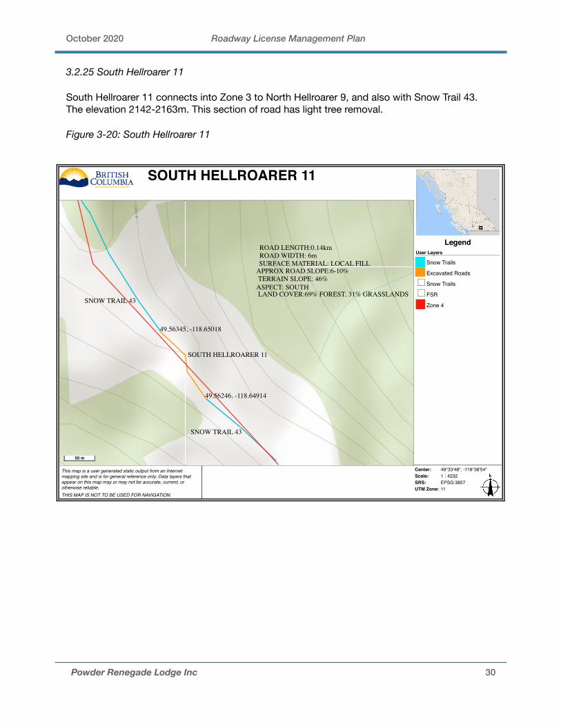
3.2.25 South Hellroarer 11
South Hellroarer 11 connects into Zone 3 to North Hellroarer 9, and also with Snow Trail 43. The elevation 2142-2163m. This section of road has light tree removal.
Figure 3-20: South Hellroarer 11
Powder Renegade Lodge Inc 30
This map is a user generated static output from an Internetmapping site and is for general reference only. Data layers thatappear on this map may or may not be accurate, current, orotherwise reliable. THIS MAP IS NOT TO BE USED FOR NAVIGATION.
Center: 49°33'48", -118°38'54"Scale: 1 : 4232SRS: EPSG:3857UTM Zone: 11
LegendUser Layers
Snow Trails
Excavated Roads
Snow Trails
FSR
Zone 4
SOUTH HELLROARER 11
49.56345, -118.65018
49.56246, -118.64914
SNOW TRAIL 43
SNOW TRAIL 43
SOUTH HELLROARER 11
ROAD LENGTH:0.14kmROAD WIDTH: 6mSURFACE MATERIAL: LOCAL FILL
APPROX ROAD SLOPE:6-10%TERRAIN SLOPE: 46%
ASPECT: SOUTHLAND COVER:69% FOREST, 31% GRASSLANDS
50 m
October 2020 Roadway License Management Plan
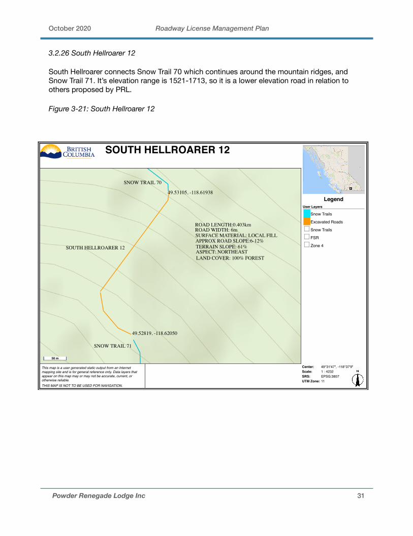
3.2.26 South Hellroarer 12
South Hellroarer connects Snow Trail 70 which continues around the mountain ridges, and Snow Trail 71. It’s elevation range is 1521-1713, so it is a lower elevation road in relation to others proposed by PRL.
Figure 3-21: South Hellroarer 12
Powder Renegade Lodge Inc 31
This map is a user generated static output from an Internetmapping site and is for general reference only. Data layers thatappear on this map may or may not be accurate, current, orotherwise reliable. THIS MAP IS NOT TO BE USED FOR NAVIGATION.
Center: 49°31'47", -118°37'9"Scale: 1 : 4232SRS: EPSG:3857UTM Zone: 11
LegendUser Layers
Snow Trails
Excavated Roads
Snow Trails
FSR
Zone 4
SOUTH HELLROARER 12
SOUTH HELLROARER 12
SNOW TRAIL 70
SNOW TRAIL 71
49.53105, -118.61938
49.52819, -118.62050
ROAD LENGTH:0.403kmROAD WIDTH: 6mSURFACE MATERIAL: LOCAL FILLAPPROX ROAD SLOPE:6-12%TERRAIN SLOPE: 61%ASPECT: NORTHEASTLAND COVER: 100% FOREST
50 m
October 2020 Roadway License Management Plan
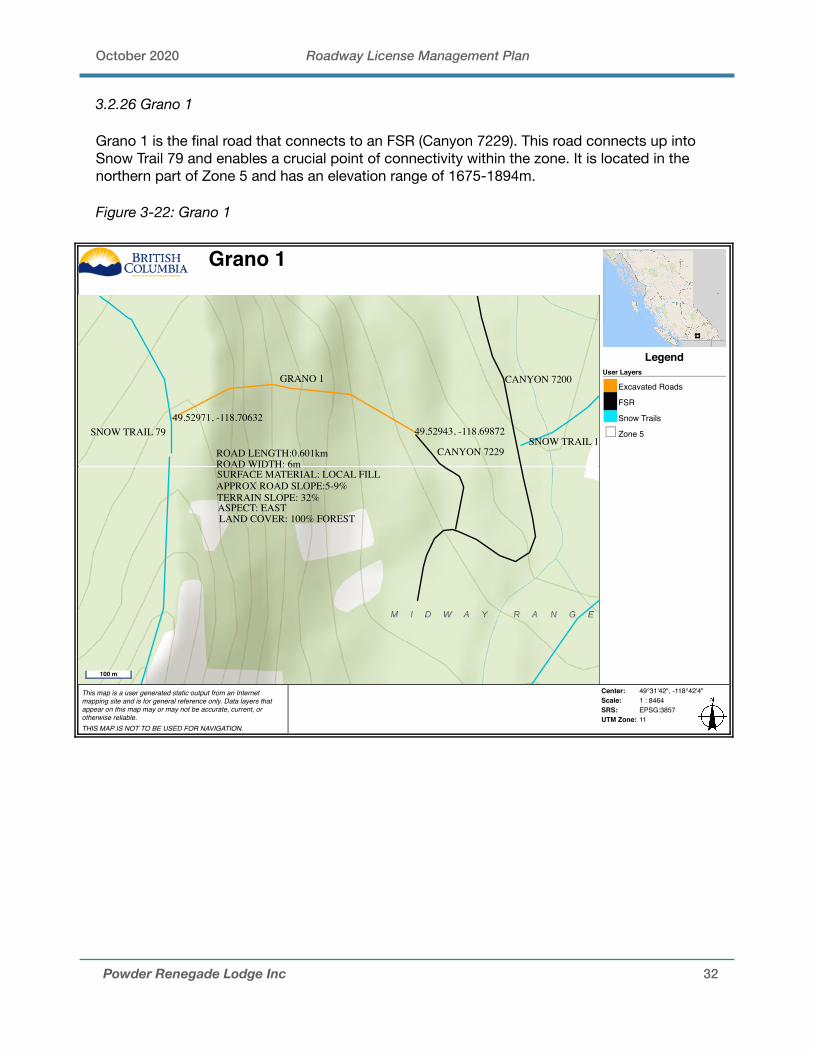
3.2.26 Grano 1
Grano 1 is the final road that connects to an FSR (Canyon 7229). This road connects up into Snow Trail 79 and enables a crucial point of connectivity within the zone. It is located in the northern part of Zone 5 and has an elevation range of 1675-1894m.
Figure 3-22: Grano 1
Powder Renegade Lodge Inc 32
This map is a user generated static output from an Internetmapping site and is for general reference only. Data layers thatappear on this map may or may not be accurate, current, orotherwise reliable. THIS MAP IS NOT TO BE USED FOR NAVIGATION.
Center: 49°31'42", -118°42'4"Scale: 1 : 8464SRS: EPSG:3857UTM Zone: 11
LegendUser Layers
Excavated Roads
FSR
Snow Trails
Zone 5
Grano 1
SNOW TRAIL 7949.52971, -118.70632
49.52943, -118.69872
GRANO 1
CANYON 7229
CANYON 7200
SNOW TRAIL 11ROAD LENGTH:0.601kmROAD WIDTH: 6mSURFACE MATERIAL: LOCAL FILLAPPROX ROAD SLOPE:5-9%TERRAIN SLOPE: 32%ASPECT: EASTLAND COVER: 100% FOREST
100 m

October 2020 Roadway License Management Plan
3.2.27 Grano 2
Grano 2 is between Snow Trail 61 and Snow Trail 13. It is located in the central region of Zone 5 and has an elevation range of 1861-1884m. It also crosses stream 471691011.
Figure 3-23: Grano 2
Powder Renegade Lodge Inc 33
This map is a user generated static output from an Internetmapping site and is for general reference only. Data layers thatappear on this map may or may not be accurate, current, orotherwise reliable. THIS MAP IS NOT TO BE USED FOR NAVIGATION.
Center: 49°30'38", -118°42'27"Scale: 1 : 4232SRS: EPSG:3857UTM Zone: 11
LegendUser Layers
Snow Trail
Excavated Roads
FSR
Snow Trails
Zone 5
Grano 2
STREAM CROSSING49.51114, -118.70820
49.51002, -118.70997
GRANO 2
SNOW TRAIL 13
SNOW TRAIL 61
ROAD LENGTH:0.187kmROAD WIDTH:6mSURFACE MATERIAL: LOCAL FILLAPPROX ROAD SLOPE:6-12%TERRAIN SLOPE: 58%ASPECT: SOUTHLAND COVER: 100% FORESTSTREAM CROSSING: 471691011
50 m
October 2020 Roadway License Management Plan
4.0 ENVIRONMENTAL
PRL has a R.P Biologist prepared Environmental Impact Assessment for the proposed works within the tenure. This document is listed in Appendix 1.0 of the Powder Renegade Lodge Adventure Tourism Commercial Recreation Tenure Management Plan. PRL has highlighted key areas of potential environmental impacts and mitigation strategies.
New roads will require detailed assessments. Findings could result in moving infrastructure locations or timing restrictions for construction activities that are could be disturbing to wildlife. Timing of the assessment will be best done in summer during nesting season, breeding season for amphibians (at the pond) and when vegetation is easiest to identify.
4.1 Stream Crossings
The proposed area is entirely within the Kettle River watershed. There is existing information for all steams with confirmed no-fish presence in all of the area. The streams that run through the proposed area to the west are tributaries to Rendell Creek (WSC 320-72800).
There are a total of 7 stream crossings necessary for the entire road network. The Water Sustainability Act applies to all works in or around watercourses including stream crossings and water use. These works require notification or authorization. PRL has reviewed Section 39 of the Water Sustainability Act and has determined that their proposal meets Section 39 (1) (a) criteria, and will submit and application for Notification for works in and about a stream for each stream crossing. As per the Forest Road Engineering Guidebook, a detailed site plan is usually not required for stream culverts not classified as major culverts or those installed on non-fish-bearing streams.
All waterbodies and water-filled ditches must have natural hydrology maintained (ie., building new roads will not redirect flows) for potential amphibian breeding. Potential amphibian breeding sites within 100m of new roads will have buffers of 10m where no existing vegetation or cover (including woody debris) will be removed.
All new stream crossings will be constructed to forestry standards and will require construction mitigation including diversion during installation, and erosion and sediment control measures.
4.1.1 Ford Design & Construction on Non-Fish Streams
A ford is a dip in a road constructed to facilitate crossing a stream. The objective of a ford is to maintain drainage and provide a safe, erosion-free, and storm-proof crossing that requires little or no maintenance. For a ford, the road profile dips into and out of the stream, creating a concave shape sufficient to ensure that the stream cannot be diverted away from its natural channel and down the road.
In isolated locations where maintenance equipment may not be available on a continuing basis, properly designed and constructed fords require little maintenance, and can be effective in reducing adverse impacts in drainage systems that are prone to debris flows or debris floods (Figure 3-16). Because these stream crossings are for areas of low traffic and intermittent use, a ford is a great alternative to bridges or culverts.
Powder Renegade Lodge Inc 34

October 2020 Roadway License Management Plan
PRL is proposing the installation of a ford for each proposed stream crossing because of the seasonal, intermittent, isolated and non-fish bearing properties of the collective values considered.
Objectives of the ford road and corresponding design are to pass the design peak flow, minimize downstream erosion of the stream, prevent sediment input into the stream from the approaches and associated ditches, provide a suitable road profile to accommodate safe passage of the design vehicle, ensure that the stream remains in its channel and cannot be diverted down the road or ditches; and ensure that the ford will either pass channel debris-the preferable option-or trap it.
Figure 4-1 Ford Road Profile, Stream Cross-Section
Figure 4-2 Stream Profile, Road Cross Section
Powder Renegade Lodge Inc 35
October 2020 Roadway License Management Plan
4.2 Timber Removal Requirements
The removal of timber is necessary for the majority of proposed roads. Avoidance areas will include Wildlife Habitat Areas, OGMA’s, Whitebark Pine critical habitat.
4.2.1 Whitebark Pine
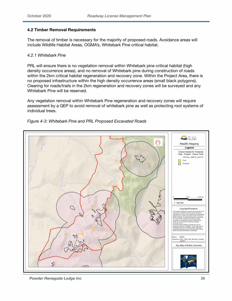
PRL will ensure there is no vegetation removal within Whitebark pine critical habitat (high density occurrence areas), and no removal of Whitebark pine during construction of roads within the 2km critical habitat regeneration and recovery zone. Within the Project Area, there is no proposed infrastructure within the high density occurrence areas (small black polygons). Clearing for roads/trails in the 2km regeneration and recovery zones will be surveyed and any Whitebark Pine will be reserved.
Any vegetation removal within Whitebark Pine regeneration and recovery zones will require assessment by a QEP to avoid removal of whitebark pine as well as protecting root systems of individual trees.
Figure 4-3: Whitebark Pine and PRL Proposed Excavated Roads
Powder Renegade Lodge Inc 36
Datum: Projection:
km6.373.190
WGS_1984_Web_Mercator_Auxiliary_Sphere
NAD83
Copyright/Disclaimer
LegendiMapBC Mapping
CAUTION: Maps obtained using this site are not designed to assist in navigation. These maps may be generalized and may not reflect current conditions. Uncharted hazards may exist. DO NOT USE THESE MAPS FOR NAVIGATIONAL PURPOSES.
Key Map of British Columbia
The material contained in this web site is owned by the Government of British Columbia and protected by copyright law. It may not be reproduced or redistributed without the prior written permission of the Province of British Columbia. To request permission to reproduce all or part of the material on this web site please complete the Copyright Permission Request Form which can be accessed through the Copyright Information Page.
1: 156,762
Critical Habitat for Federally-Listed Species at Risk - Posted - Colour Themed
CRITICAL_HABITAT_STATUS
Final
Proposed

October 2020 Roadway License Management Plan
4.2.2 Old Growth Management Areas (OGMA)
There are non-legal Old Growth Management Areas designated in the Project Area. These areas have been designated during Landscape Unit planning to meet biodiversity objectives but in theory could be amended if tree removal was required. Where tree removal is proposed, PRL will seek approval from the Forest District (if required).
Figure 4-4: Non-legal Old Growth Management Areas vs PRL Excavated Roads
4.3 Soil Erosion and Invasive Species
To minimize surface soil erosion and invasive weed colonization after road construction, all disturbed soils will be seeded with an erosion control grass seed mix. A variety of erosion seed mixes are available that provide for rapid germination and long- term growth to create a solid layer. The seed species selected will be compatible with native species and soil.
Powder Renegade Lodge Inc 37
Datum: Projection:
km5.872.940
WGS_1984_Web_Mercator_Auxiliary_Sphere
NAD83
Copyright/Disclaimer
LegendiMapBC Mapping
CAUTION: Maps obtained using this site are not designed to assist in navigation. These maps may be generalized and may not reflect current conditions. Uncharted hazards may exist. DO NOT USE THESE MAPS FOR NAVIGATIONAL PURPOSES.
Key Map of British Columbia
The material contained in this web site is owned by the Government of British Columbia and protected by copyright law. It may not be reproduced or redistributed without the prior written permission of the Province of British Columbia. To request permission to reproduce all or part of the material on this web site please complete the Copyright Permission Request Form which can be accessed through the Copyright Information Page.
1: 144,448
Old Growth Management Areas - Non Legal - Colour Filled
October 2020 Roadway License Management Plan
4.4 Drainage Control Measures
Any permanent culvert materials will be fabricated in accordance with the current Canadian Standards Association specifications. To maintain surface drainage patterns, PRL will keep water in its own drainage area, unless moving it to another area is necessary to avoid unstable or sensitive soils. Before culvert locations and outlet controls are determined the potential for adverse upslope, downslope and downstream impacts will be considered. Measures to limit these impacts include: installing flumes or riprap; or carrying drainage flow farther along the ditch line to discharge it onto stable slopes.
Drainage systems are used to intercept and manage surface or subsurface drainage. If the soils are easily erodible, PRL will consider changing the ditch gradient, alignment, or cross-section, or adding extra culverts, to reduce the distance over which water will have to be carried. To minimize sediment delivery to streams, the water conveyed in ditches and cross-drain culverts will not be discharged directly into streams. These flows will be allowed to settle out through the natural vegetation on the forest floor before reaching any stream.
PRL will install drainage systems, permanent or temporary, concurrently with subgrade construction. Temporary structures, such as cross- ditches, swales, will be considered where water is encountered, to accommodate the peak flows likely to be encountered during construction.
If a storm takes place, the in-place drainage structures will be capable of handling the runoff without damage resulting to the road or other resources. These can accommodate surface and subsurface drainage runoff throughout the construction period.
4.5 Wildlife and Sensitive Habitats
Refer to Appendix 1.0 in PRL’s License of Occupation Tenure Management Plan for a full Environmental Impact Assessment and wildlife mitigation. With respect to road building, the main species of concern is Grizzly Bear habitat.
4.5.1 Grizzly Bear
No roads or trails to be constructed within 50m (with exceptions of required stream crossings and 1 crossing of an avalanche track if unavoidable) of:
1. Avalanche tracks2. Hedysarum, glacier lily (Erythronium) and spring beauty complexes >0.5ha (preferably
>0.2ha)3. Subalpine parkland meadows 4. ESSFdc1 site series 06, 07 (1990) / 08, 09, 10 (2005).
Powder Renegade Lodge Inc 38
October 2020 Roadway License Management Plan
5.0 ROAD INSPECTION AND MAINTENANCE
Road inspections will occur during spring freshet, as the majority of the higher elevation roads will not be accessible once the snow trails have melted. Recommended maintenance would be completed in the fall when the snow trails begin accumulation. If an inspection determines a drainage structure is compromised immediate steps need to be taken to mitigate problems.
4.0 IMPACTS ON OTHER USERS
The majority of PRL’s proposed roads will be constructed between snow trails, with only 4 roads connecting to FSR’s. These roads are being constructed for the sole purpose of PRL’s cat skiing operation. PRL is avoiding connecting their roads to FSR’s unless necessary to avoid opening up the high alpine terrain to summer users (ie, ATV’s, dirt bikes and recreational hiking). The majority of these roads will not be accessible to other users.
The roads that connect to FSR’s are smaller extensions, which are not high alpine. The main access road will provide year round access to the lodge site, which we do not anticipate many other users to be interested in using. PRL will remain open to discuss any possible road use agreements with other licensees in the area, if they wish to use the roads PRL is creating.
6.0 RECLAMATION
If PRL ceases to use a road, appropriate deactivation measures will be assessed and executed. PRL anticipates a minimum 30 year term for the use of these roads.
Powder Renegade Lodge Inc 39