robinson forest wildlife management area index map · robinson forest wildlife management area map...
TRANSCRIPT

Robinson Forest Wildlife Management Area Index Map
!
!
!Guage
Jackson
Hardshell
BREATHITT
KNOTT
MAGOFFIN
PERRY
No Hunting without permission of UK
UV1098
UV542
UV476
UV30
UV1110UV397
UV1502
UV15
UV1812
UV205
UV1635
UV7
UV3237
UV3324
UV378
UV1087UV1933 UV1278
UV1471UV1734
UV1516
UV541
UV394UV1397
UV2472
UV52UV3232
UV30
UV1087
UV7
Map 2
Map 1
North Fork Kentucky River
USGS, DGI
82°58'W83°0'W83°2'W83°4'W83°6'W83°8'W83°10'W83°12'W83°14'W83°16'W83°18'W83°20'W83°22'W83°24'W83°26'W
37°38'
N37°
36'N
37°34'
N37°
32'N
37°30'
N37°
28'N
37°26'
N
0 0.5 1 1.5 2 2.5 3 MileMap prepared by Kentucky Department of Fish & Wildlife Resources (KDFWR). Although KDFWRstrives for accuracy, data used to create this mapare from a variety of sources and dates; as such,KDFWR makes no representations regarding theaccuracy or fitness for use of the informationfurnished herein.
Note to Map Users
Publication Date: 2/14/2018
A map legend and additional informationare provided on PDF pages thataccompany this map. ® Scale 1:170,000
Quicksand Creek Big Caney Creek
Troublesome Creek
OffLimits
*Shading indicates topography

Robinson Forest Wildlife Management Area Map 1
!
!Guage
Jackson
#
Quicksand CreekBig Caney Creek
North Fork Kentucky River
Panbowl Lake
UV1098
UV542UV30
UV540
UV1812
UV2436
UV15
UV378
UV2466
UV1397UV394
UV2472
UV3232
UV2471
UV15
Kentucky DGI, KyFromAbove Partners, USGS, DGI
83°6'W83°8'W83°10'W83°12'W83°14'W83°16'W83°18'W83°20'W83°22'W
37°38'
N37°
36'N
37°34'
N37°
32'N
0 0.5 1 1.5 2 2.5 3 MileMap prepared by Kentucky Department of Fish & Wildlife Resources (KDFWR). Although KDFWRstrives for accuracy, data used to create this mapare from a variety of sources and dates; as such,KDFWR makes no representations regarding theaccuracy or fitness for use of the informationfurnished herein.
Note to Map Users
Publication Date: 4/6/2020Land Classification from NationalLand Cover Database 2011
A map legend and additional informationare provided on PDF pages thataccompany this map. ®
Contour interval: 200 feetScale 1:100,000
See adjoining Map 2
OffLimits
*Shading indicates topography
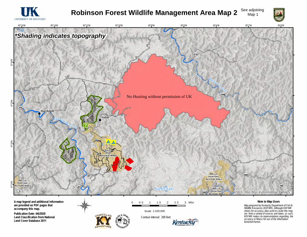
Robinson Forest Wildlife Management Area Map 2
!
!
!9
NobleHardshell
Paul Van
Booven WMA
Wells Hunting
Access AreaWells Hunting
Access AreaWells
Hunting Access Area
No Hunting without permission of UK
Quicksand Creek
Troublesome Creek
Starfire Lake
UV1098
UV476
UV1087
UV15
UV1516
UV267 UV160
UV1087 USGS, DGI, DGI, KyFromAbove Partners
83°0'W83°2'W83°4'W83°6'W83°8'W83°10'W83°12'W83°14'W83°16'W
37°30'
N37°
28'N
37°26'
N37°
24'N
0 0.5 1 1.5 2 2.5 3 MileMap prepared by Kentucky Department of Fish & Wildlife Resources (KDFWR). Although KDFWRstrives for accuracy, data used to create this mapare from a variety of sources and dates; as such,KDFWR makes no representations regarding theaccuracy or fitness for use of the informationfurnished herein.
Note to Map Users
Publication Date: 4/6/2020Land Classification from NationalLand Cover Database 2011
A map legend and additional informationare provided on PDF pages thataccompany this map. ®
Contour interval: 200 feetScale 1:100,000
See adjoining Map 1
*Shading indicates topography

Robinson Forest WMA Information
Public Hunting Area Location
Regional Locator
WMA Overview Location & Size: Breathitt, & Perry counties, 2,003 acres. Contact: Becky Littleton 606-877-8409 Elevation: minimum 760 feet, maximum 1560 feet. Entrance GPS coordinates: Latitude N 37.45023, Longitude W -83.19541 Area Habitat: mostly forest: open land 15%, forest 86%, wetland 0%, open water 0%.
Directions & Description: Robinson Forest is located east of Jackson and Clayhole. Head east of Clayhole on HWY 476 about 8 miles, and turn on Little Buckhorn RD and the county line. See map for open areas in Breathitt and Perry county (Rose Branch, Little Caney Creek north, Bear branch, Fishtrap Branch, and Beaver Dam). See the Fall Hunting and Trapping Guide for additional information concerning hunting seasons. Owned by University of Kentucky. This property is located within Elk Hunting Unit 4. Please refer to the elk hunting portion of our website.
Online Resources Public Hunting Area users must abide by the Kentucky hunting, trapping, and fishing regulations. It is incumbent on persons using Public Hunting Areas to become familiar with these regulations. Kentucky Department of Fish & Wildlife Resources provides these regulations on our Web site at fw.ky.gov or by calling 1-800-858-1549.

WMA Map Legend!? WMA Office
!] Information Kiosk¾!i Check station¾s Mobility-impaired Hunting Blind
!F Trailhead
!È Horseback Trailhead
!i Parking Lot
!5 Picnic Area
!_ Restrooms
![ Wildlife Viewing Site
!Õ Interpretive Site
!Í Retriever Training SiteGate
!9 CampgroundÀ¾ï Cemetery
Corps of Engineers OfficeWaterfowl Blind
¾ÆO Shooting Range
!l Established Bank Access
¾O Fishing Pier
¾\ Carrydown Launch
!y Small Boat Ramp
!y Large Boat Ramp
!@ State Park Office
WMA BoundaryAerial photographOther Public Hunting AreasArea Off LimitsNo HuntingSeasonally Restricted AccessMobility Impaired Hunting AreaPrimitive Hunting OnlyFoot Traffic OnlyOpen WaterWetlandWoodland
! Populated PlaceKentucky BoundaryInterstate HighwayKentucky ParkwayU.S. HighwayState HighwayLocal RoadForest Service RoadActive RailroadAbandoned RailroadFederal Recreation TrailWMA RoadWMA Foot TrailWMA Horse Trail
!! !! !! Gas PipelinePowerlineRivers and StreamsDamTrout WatersElevation Contour
§̈¦75
£¤60
UV169
4596
OffLimits
Wildlife Management Area Map Notes & LegendNOTE TO MAP USERS:For most WMA maps the landscape is depicted using a combination of elevation contours, hillshadingand a green tint indicating woodland areas that is derived from satellite imagery. On WMAs that arerelatively small or have a history of surface mining aerial photography is used.
Named Road"2
#
P
SeeGuide