rock classification (2) (1)
TRANSCRIPT
7/25/2019 Rock Classification (2) (1)
http://slidepdf.com/reader/full/rock-classification-2-1 1/18
Report
on
Geo-technical
Investigation
of
I{ight
Bank
Abutrnent
Slope
of
the
l(ali
Gandaki
Bridge
along
Ridi
--
GalyangRoad
Sr-rbnritteci
to:
f;ovcntntcn1
0l'Nepal
h.'[
i
nistr'.1
o1-
Pir-r,sicaI
Irrll'astntctltre
&'l'ransport
I)cparlnrcnl
o I Roads
\\/cstcrn
[iegional
Roads
Directolate
I)ivision
l{oacls
Office
Palpa
Submitted
by:
Prestigc
Consulting
(P.) I-td.
A
n
a n'r
na
gar,
1(
athrn
a
ncltl
Pl-ionc:
4416054
2012113
7/25/2019 Rock Classification (2) (1)
http://slidepdf.com/reader/full/rock-classification-2-1 2/18
Acknowledgements
\\ie
lvorrlcl
Iil<c
to cxllrcss
our
sincerc
gratitLrde
to Dcparttlletrt
of
Roecls,
Divisiorl
Roads
O{1ice'
irirlPa
lbr'Plovicii,,g
Lis the
oppoltLrnitv
to
carry
o[tt
the
presenl-]ob.
We
l'oLIld
also
lilic
to
thatrli
l:r..
i(.
Ranubhat.
tlte Division
Chief
tbr
his
valLrable
sLtppoIt.
suggcstions
atrcl
cot.lttrtcrrts
cltttltrr
tlrc
coursc
ol
thc
srLrclr,.
N,l'oreover.
thanl<s
also
go to
llr.
I(cshav
0.iha,
Ilrrgirlccr.
DRO
Palpa
lilr
ir
is
lirrrl eoollcr.li{ion
artcl
sLtppotl.
Llrst
SLrl
uttt
thc
lcast.
rve woulcl
lrlic
to
cxptcss
ortt'siltect"c
lrllIrcciltit'tl
lttrcl
grirtitLrclc
ttl
cnsinccr.s
anrl
thc sial'f'of'the
DRO.
[,alpa
lbr
their
l<inr]
help
ancl
Iogistic
stlpllort.
lt
is
orlli'tt'iLh
rlr.:rr.,
111r,,,'t
o1'all
cottcerrlccl
that
the
prtscirt
stirdy
coLr
lcl be
comllietccl'
(
Pral<a-sh
C
itirrttlra
(ihirrlirc)
Scnior
Cicologisl
Prcstigc
Coristrlting
(.P) t,ttl.
Anantnagar.
Kathtllancltt

7/25/2019 Rock Classification (2) (1)
http://slidepdf.com/reader/full/rock-classification-2-1 3/18
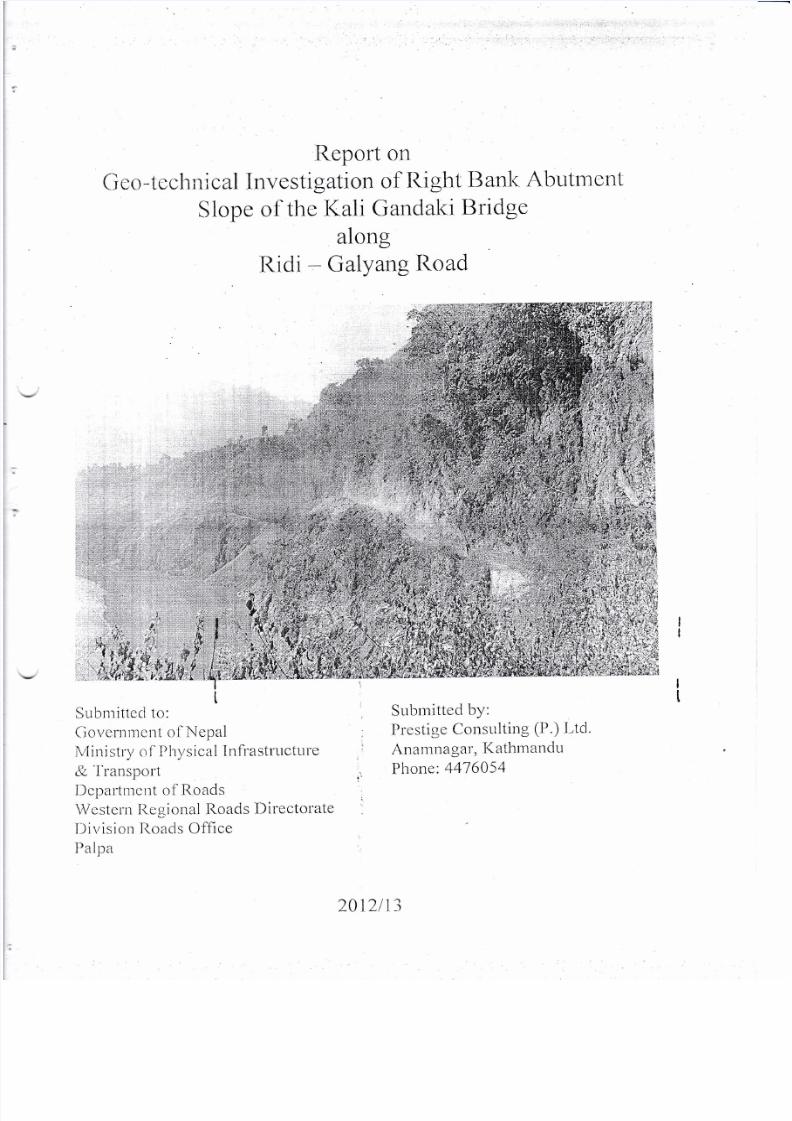
1.0 lntroductiorr
The
geotechnical investigation
I
study
of
motorable
bridge
over
Kaligandaki
river
along
Ridi
-
Glyang
road
of Gumi-syanja
district
has been
carried
out
for
Division
Road
Office,Palpa'The
bridge
is
under
construction.
The main objectives
of present
study were:
.
Geological/Geoteclrnical
assessment
of
bridge
site
.
Failure
Assessment
of
rock
slope
cut
at
bridge
axis
.
Rocl<mass
Classification
of
bridge
site
2.0 Methodology
.
Thc tearn.
has
drscussed
with
personals
of
Bridge
project,
DoR
and
DRO
Palpa
to
know
problcm
of construction
site.
Then
present stucly
was
divided
into
two
stages:
n
Ficld
study
(Site
Visit
for
data
collection)
.
Office study
(Data processing,
analysis
and
report
preparation)
In
freid stuciy
geoiogicai
study
was
carricd
by
geological
travei'se
along
i'oad
corridor
and
rivcr
banl<
of
l(aligandaki
River
at
vicinity of
bridge
construction
site'
Main
rocl<
type
and
cliscontir'tuities
type were
identified
during
field
study'
The
oricntations
of
discontinuities
were
measured
along
cut
slope
of
road
corridor
and
river
bank.
A
scan
line survey
and
window
survey
was
carried
out
for
discontinuity
mapping
to
assess
stability
scenario
of
bridge
foundation
and
cut
slope. The rock
mass
classification
was
carriecl
by Geomechanics
Classification(
Bieniawasl<i's
Rock
Mass
Rating
System)
to
assess
rocl< mass
class
of,bridge
site.
I
tl
3,0 Site
Geology
The bridge
site
lids at
the
lesser
Himalayan
Zone
of
Western
Nepal.
The
major
rock
types
of
.t
bldge srte
are
grey-dark
grey
colored
,
fine-medium
grained,
foliated
and
closely
-u"'d
closely
spaced,moderately
-slightly
weathered
Phyllite
bed
rock
with
interbedding
of
Dolorrite/euartzite.The
bridge
axis
lies at
steep
rock
slope.
The
rocl<
exposure
at Ridi
side
is
highly
weathered
and
sheared.
Series
of
ahare
zones
have
been
observed
at
the
road
cut
slope.
Ground
water
seepage
and
flow
is
frequent.
zl.0
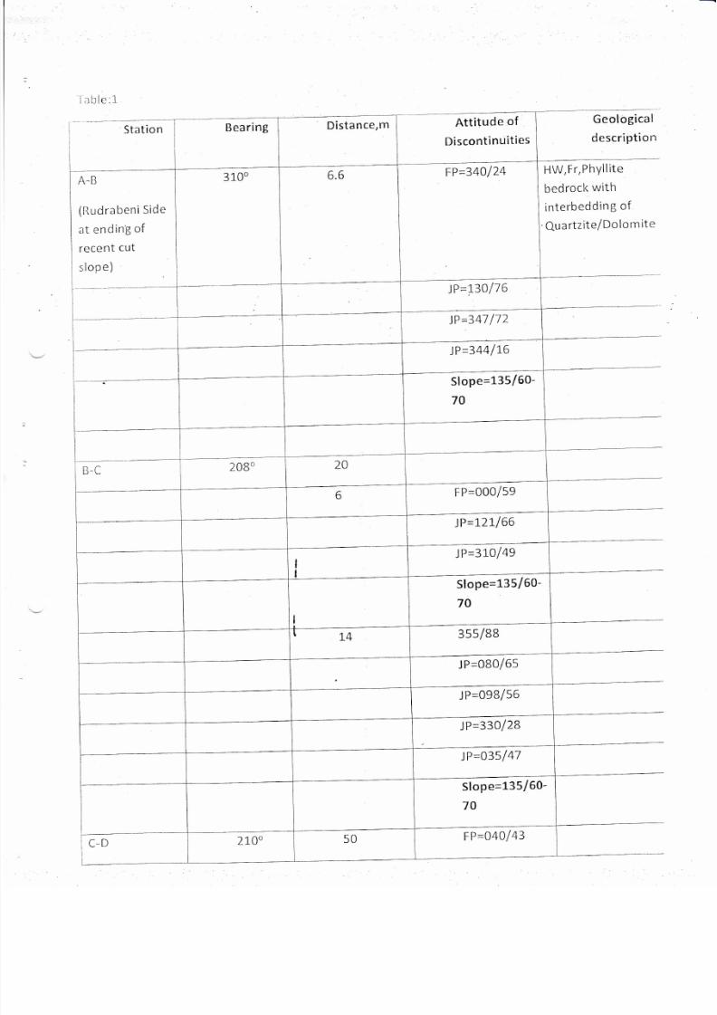
Discontinuity
Survey
Discor-rtinuity
Survey
was
carried
along
road
corridor
and
river
banl<'
The
changes
in
orientatlon
of discontinuity
has been
noticed
and
recorded
at
chainagewise
measurement
frorn Rudrabeni
sicle
to
Ridi
side.
The
starting
point
of scanline
survey
is at
the
ending
of
recent cutslope
towards
Rudrabeni
side and
ended
at
Ridi
Side
upto
recent
cut
slope.The
chainagewise
description of discontinuity
is
given
below:
7/25/2019 Rock Classification (2) (1)
http://slidepdf.com/reader/full/rock-classification-2-1 4/18
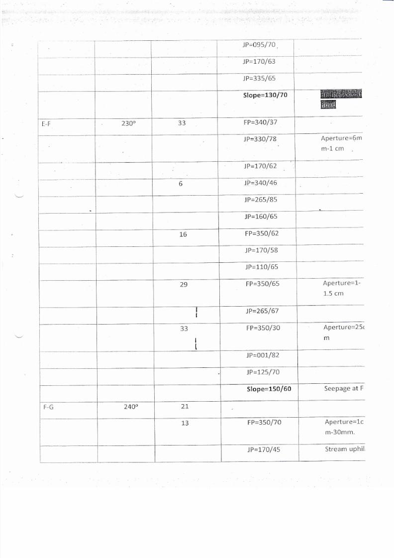
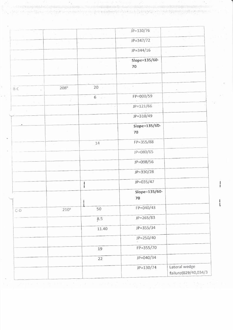
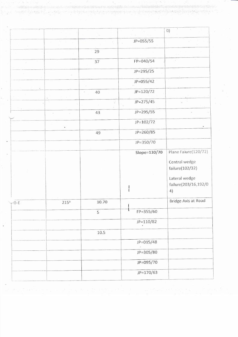
iable:i
Bearing
FP44Ol74
A.B
(llLrdrabcni
Side
at
ending
of
recent
cut
slope)
JP=r30176
lP=341112
JP=344116
Slope=135/60-
70
FP=000/59
)P=1-21,166
)P=3L0149
Slope=135/60-
7A
3ss/BB
J
P=080/65
)P=33ol2B
JP=O35147
Slope=1-35/60-
70
tP=o40143
Station
Attitude
of
Discontinuities
Geological
description
tlW,Fr, PhYllite
bedrock
with
interbedding
of
Qu
a
rtzite/Do
lo
rn
ite
7/25/2019 Rock Classification (2) (1)
http://slidepdf.com/reader/full/rock-classification-2-1 5/18
I
I
t-
l
I
t_,
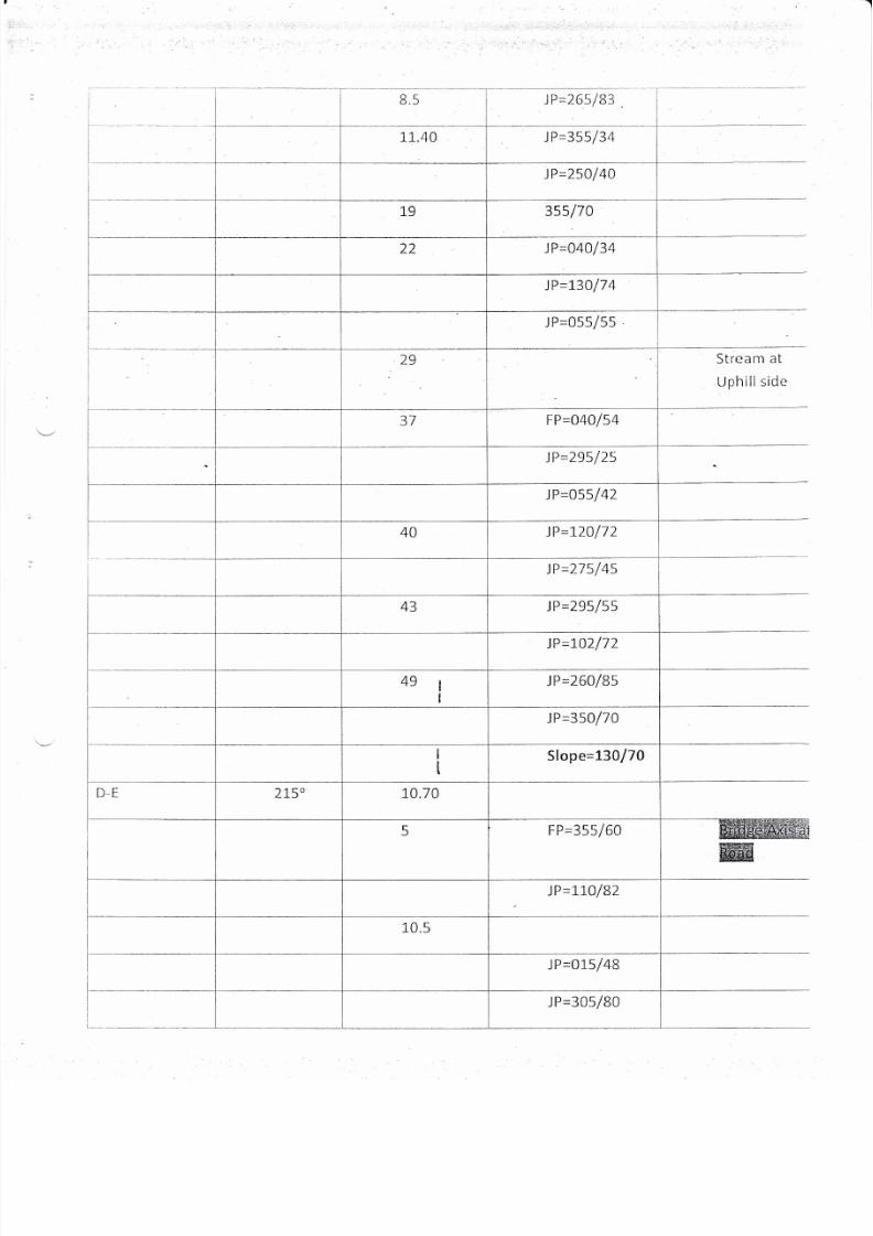
)P=265183
Stream
at
Uphill
side
i P=355/34
JP=25Ol40
JP=04O134
JP=13017
4
J
P=055/55
FP=040154
JP=295125
JP=o55/42
lP=12O172
JP=215145
JP=795/55
JP=1"02172
JP=260185
JP=35O17O
Slope=130170
FP=355/60
JP=1,LO/BZ
JP=0L5148
lP=305/80
7/25/2019 Rock Classification (2) (1)
http://slidepdf.com/reader/full/rock-classification-2-1 6/18
JP=O95/lA
Aperture=6m
m-l-
cm
Aperture=1-
1.5 cm
Ap
e
rtu re=2
5r
m
Seepage
at
F
Aperture=1c
m-30mm.
)P=110163
J
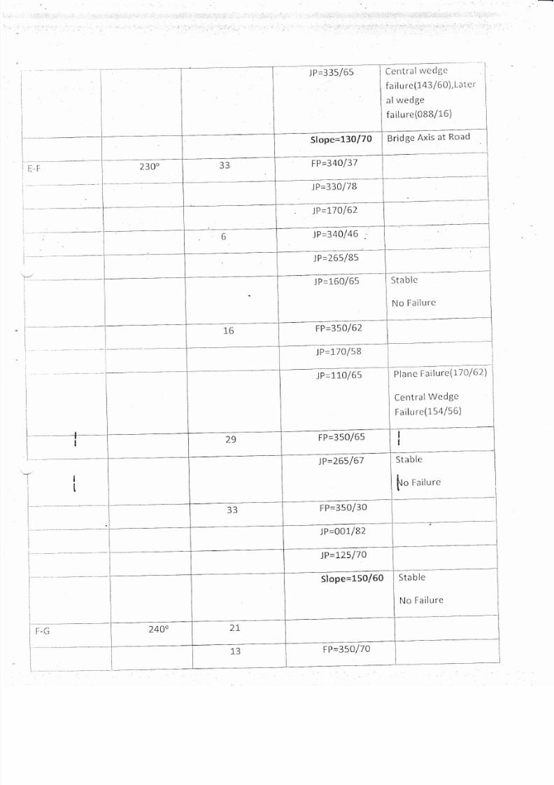
P=335/65
Slope=130/70
FP=340/37
JP=330/78
JP=170162
)P=340146
)P=265185
JP=L6O/65
FP45A/62
JP=1-7Ol58
J
P=110/65
F
P=350165
JP=265/67
FP=350130
J
P=001/82
JP=L25l70
FP=350/70
JP=170/45
Stream
r,rplrii

7/25/2019 Rock Classification (2) (1)
http://slidepdf.com/reader/full/rock-classification-2-1 7/18
i
L
I
I
L
I
l
I
I
.lP=0BB/82
Slope=150/60-
1.3o17O
c-ll
)150
o-)
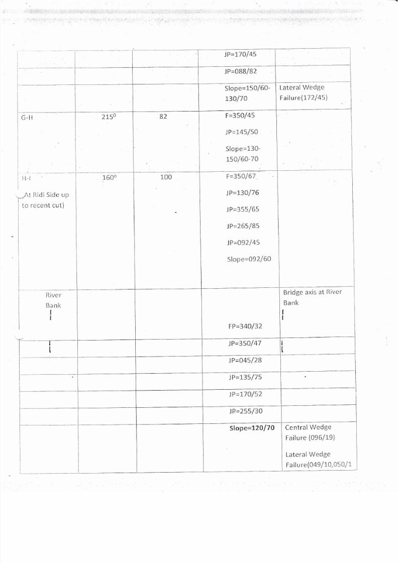
F=350145
J P=145/50
Slope=130-
$a160-70
llW,Fr,Phyllite
bedrock
wlth
intercalation
of
Qu
a
rtzite/Dolom
ite
Share
Zone,Water
scepaSe
zonc
il-l
(At
RidiSide
Lr;r
to
recent
cut)
1600
100
F=350/67
tP=13A/76
JP=355/65
tP=265185
tP=o92/45
Slope=092/50
llW,Fr,Phyllite
bedrocl<',ryrih
intercalation of
Quartzite/Dolomite
Share
Zonc,Water
seepage
zone
Rive r
Banl<
FP=34A/37
Bridge
axis
at
River
Uanl<
)P=350147 SW-MW,
Fr, Phyllite
bedrock
with
intercalation
of
Quartzitc/Doiom
ite
JP=045/28
JP=135/75
JP=170/52
)P=255/30
7/25/2019 Rock Classification (2) (1)
http://slidepdf.com/reader/full/rock-classification-2-1 8/18
SIope=3.20l70
Source:
Field
Measurement
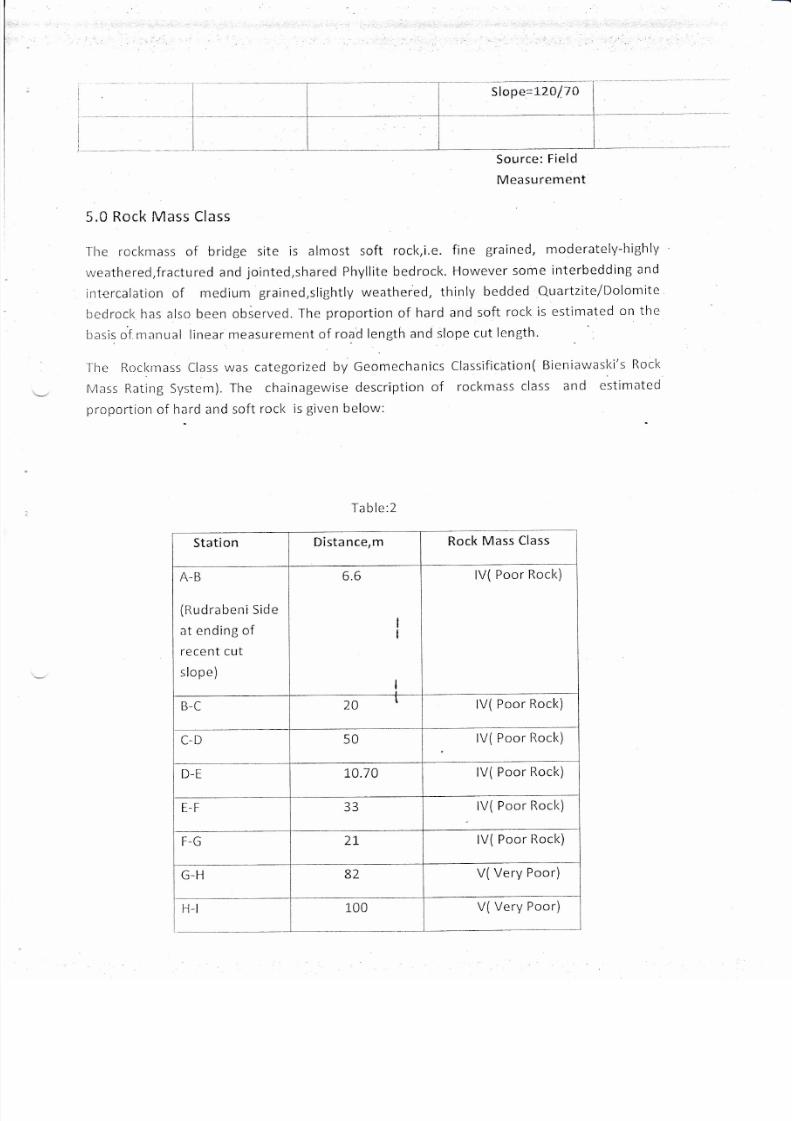
5.0
Rock Mass
Class
I
hc
rocl<mass
of bridge
site
is
almost
soft
rock,i.e.
flne
grained,
moderately-highly
weathered,fractured and
jointed,shared
Phyllite bedrock.
However
some
interbedding
and
intercalation
of
medium
grained,slightly
weatlrered,
thinly
bedded
Quartzite/Dolonrite
ltcclrocl< has also
becn
observed.
The
proportion
of
hard
and
soft
rocl<
is
estimatcd
on the
basis of
rnanual linear
measLlrement
of
road
length and
slope
cut
lcngtlr.
Ihc
Roclcrnass CIass
was categorized
by
Geomechanics
Classification(
Bieniawasl<i's
flocl<
Mass
Rating System).
The chainagewise
description of
rocl<mass
class
atrd
cstlmatcd
proportion
of
hard
and
soft
rocl< is
given
below:
Table:2
Station
Distance,m
Rock
Mass
Class
A-B
(ttudrabeni
Side
at ending
of
recent cut
slope)
6.6
lV(
Poor
Rock)
B-C
20
lV(
Poor
Rock)
C-D
50
lV( Poor
Rock)
D-E
1U.
/U
lV( Poor
Rock)
E-F
J:)
lV(
Poor
Rock)
F-G
71
lV(
Poor
Rock)
G-H
6L
V(Very
Poor)
H-t
100
V(
Very Poor)
7/25/2019 Rock Classification (2) (1)
http://slidepdf.com/reader/full/rock-classification-2-1 9/18
(At
Ridi
Side
up
to
recerri
cut)
At River
Bank
223
lll-(Fair
Rock)
Source:
Manual
Measurement
of
Linear Distance
at
field
study
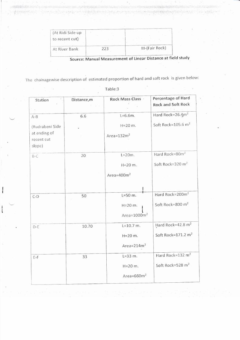
I
he
chainagetruise
description
of
cstimate
d
proportiorr
of
hard
and
soft
rocl<
is
given below:
Ta b
lc:3
Stati on
A-B
(RrrclrabeniSide
at
e
nding
of
reccnt
cut
slope)
il-,--
C-D
NI:
fC
L-l
Distance,m
Rock
Mass
Class
Percentage
of
Hard
Rock
and
Soft
Rock
6.6
L=6.6m.
Il=20
n-i.
Area=132m2
Hard
llock=26.4rm2
Soft
Rocl<=105.6
m2
2A
L=20m.
H=20
m.
Area=400m2
Hard
[]ocl<=S0rr2
Soft
Rocl<=320
m2
50
L=50
m.
ll=20
m.
I
t
Are
a=1000m2
Hard
Rocl<=200m2
Soft
Rocl<=800
nr2
10.70
L=l-0.7
m.
H=20
m.
Area=2L4m2
llard
Rock=
42.8
mZ
Soft
Rock=
17
r.2 mz
5J
L=33
m.
H=2.0
m.
Area=660m2
Hard
Soft
Rocl<=132-
m2
Rock=S28
m2

7/25/2019 Rock Classification (2) (1)
http://slidepdf.com/reader/full/rock-classification-2-1 10/18
21
L=21
nr.
ll=20
m.
Area=420
m2
Ilard
[locl<=84
rl2
Soft
Rocl<=336
rlr2
G-il
B2
L=82
m.
H=20
m.
Area=1640
m2
Hard
Rock=328
m2
Soft
Rocl<=l-312
m2
H-l
lAt
Ridi
side
up
to
rccent
cut)
100
L=100
m.
H=20
nr.
Area=2000
m2
l-lard
Rocl<=200
m'
Soft
Rock=1800
m2
At
[1ivcr
Banl<
1L)
L=223
m.
*H=15
m.
Area=3345
m2
llaro
l(ocK=oov
Ill
Soft
Rocl<=2
67
6
m2
*5loP
to bc
cut
for
brldgc
foundation
lcvcl
Note:
Cut
slope
H"igf,t
i,
*ti*ut"d
according
to
DRO
Official
information
6.0
FailUre
Assessment
I
Failure
assessrrent
was
carried
out
atthe
road
cut
slope
and
river
banl<
slope
along
bridge
axis
by
kipcmatic
analysis.
Stereographic
projection
of
discontinuity
data
has
been
carried
out.l-hc
ticscrlption
of
Failure
assessment
is
given
below:
i
Ta
ble:4
Atl
(Ruclrab
al
e
irdin
rece
r-it
c
slopc)
ta
ticn
Beari
ng
Distance,m
Attitude
of
Discontinuities
Failure
eni Side
gof
rut
3
100
6.6
34O/24
7/25/2019 Rock Classification (2) (1)
http://slidepdf.com/reader/full/rock-classification-2-1 11/18
I
l
i
j
I
t---
l
I
l
I
I
t_
I
20Bo
JP=1.30116
)P=347172
lP=344116
Slope=135/60-
70
FP=000/59
JP=3rol49
Slope=L35/6O-
70
F
P=355/BB
J P=08C/65
JP=330128
)P=o35141
Slope=135/60-
70
FP=a4ol
43
)P=265183
)P=355134
FP=355110
Lateralwedge
failure(029
140,03413
)P=13o174
I
t_-
I
I
I
I
I
I
i
7/25/2019 Rock Classification (2) (1)
http://slidepdf.com/reader/full/rock-classification-2-1 12/18
J
P=055/55
FP=04a154
JP=295125
JP=055/47
)P=L20112
tP--27514':
)P=295155
JP=LO2172
JP=260185
)P45A170
Slope=
130/70
Bridge
Axis
at
Road
F
P=355/60
JP=.tL0lBZ
i
P=305/80
JP=095170
)P=17O163
PIanc
['aiure(DAll)\
Cer-rtral
wedgc
failure(102/32)
Lateral
wedge
failurc(203
116,19210
4)
I
I
I
l-
7/25/2019 Rock Classification (2) (1)
http://slidepdf.com/reader/full/rock-classification-2-1 13/18
Ce
niral
wed6lc
fail
u rc(143/60),
I arcr'
al
wedge
f a
ilu
re(0BB/r6)
t--
I
Stablc
[.']o
Failure
t___
1
I
i
i--
I
L
i
J P=335/65
Bridge
Axis
at
Road
Slope=130/70
FP=34ol3l
)P=330178
)P=170162
)P=340146
JP=265185
Sta
b
lc
No
Failurc
J
P=160/65
tP=350162
P
I
a
n
e
F
ai
I u
r
e(77
l)
I
i;2\
Central
Wedge
F
a
ilLrrc(154/56)
)P=\7Ol58
J
P=L
10/65
FP=350/65
)P=265161
FP=350/30
JP=00L182
JP=125170
Stable
No
Failure
Slope=150/60
FP=35o110
7/25/2019 Rock Classification (2) (1)
http://slidepdf.com/reader/full/rock-classification-2-1 14/18
G-11
Side
up
nt
cut)
ll i
'.re
r
llank
I
I
Lateral
Wedge
Failure\172145)
Slo
pe=150/60-
r3o110
F=350145
J
P=145/50
Slope=130-
1so/60-70
F
=3501
67
lP=L30l76
I
P=355/65
J
P=265/85
)P=O92145
Slop
e=092/60
Bridge
axis
at
River
Bank
I
I
FP=34O/37
JP=35O/47
lP=045128
)P=1,35175
)P=]70152
JP=255130
Slope=L7A/70
Central
Wedge
Failure
(096/19)
LateralWcdgc
Failure(049
ILa,050IL
7/25/2019 Rock Classification (2) (1)
http://slidepdf.com/reader/full/rock-classification-2-1 15/18
2,055/15
)
--i
I
I
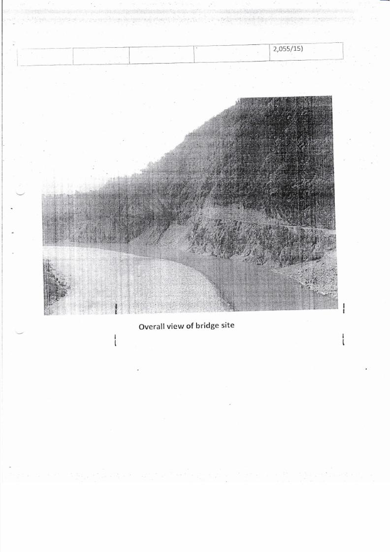
Overall
view
of
bridge
site
7/25/2019 Rock Classification (2) (1)
http://slidepdf.com/reader/full/rock-classification-2-1 16/18
r
'l'
i
:,,1-
,
:::.
,,:l
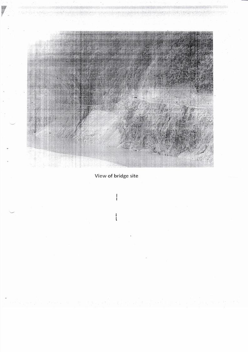
View
of
bridge site
:,
l
7/25/2019 Rock Classification (2) (1)
http://slidepdf.com/reader/full/rock-classification-2-1 17/18
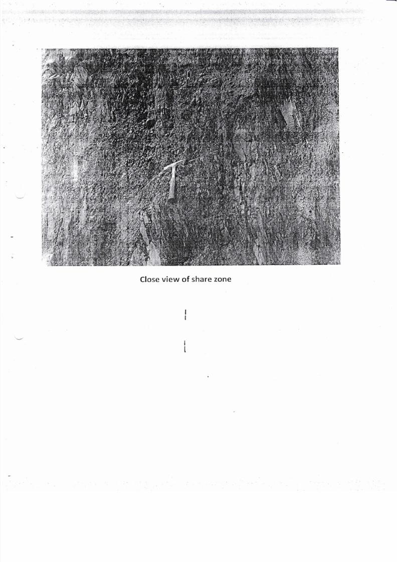
Close view of share
zone
7/25/2019 Rock Classification (2) (1)
http://slidepdf.com/reader/full/rock-classification-2-1 18/18
$:r"::
.$ini
,iiii
:]
.Jitiji
i,:l:.:,:
i.{,1
i
,1, idEi,i
.iri
ri,.ll
ii.irl,i,,
:.i::iii;lr:"i1i;r1.l
:1
:..
.:::.
*i$ffi
:.'
:.1rii
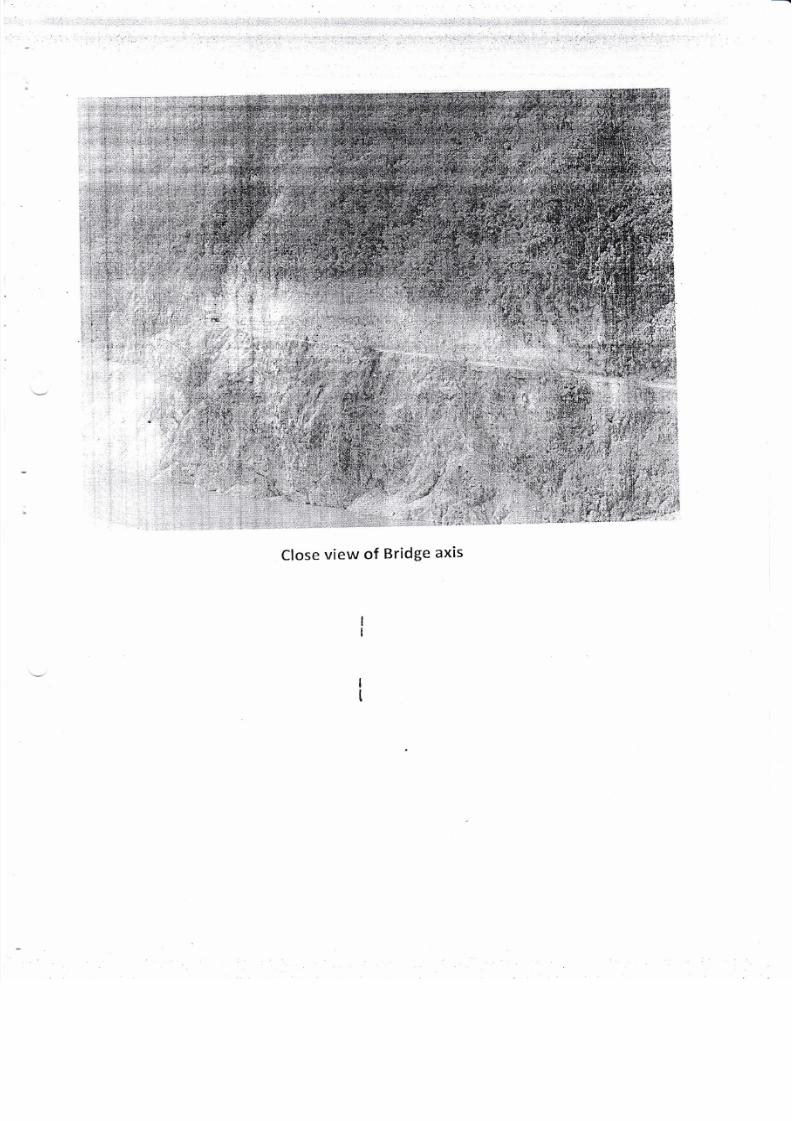
Close
view
of
Bridge
axis
i+*i-'-18 t:.
;ti