rock climbing inventory statistics rock...rock climbing inventory statistics: ... red rocks climbing...
TRANSCRIPT
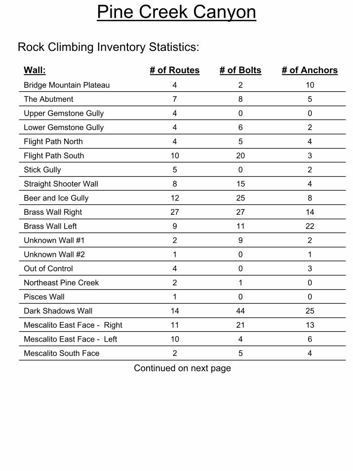
Pine Creek Canyon
Rock Climbing Inventory Statistics:
Wall: # of Routes # of Bolts # of AnchorsBridge Mountain Plateau 4 2 10
The Abutment 7 8 5
Upper Gemstone Gully 4 0 0
Lower Gemstone Gully 4 6 2
Flight Path North 4 5 4
Flight Path South 10 20 3
Stick Gully 5 0 2
Straight Shooter Wall 8 15 4
Beer and Ice Gully 12 25 8
Brass Wall Right 27 27 14
Brass Wall Left 9 11 22
Dark Shadows Wall 14 44 25
11 21 13
10 4 6
2 5 4
Mescalito East Face - Right
Mescalito East Face - Left
Mescalito South Face
Continued on next page
Unknown Wall #1 2 9 2
Unknown Wall #2 1 0 1
Out of Control 4 0 3
Northeast Pine Creek 2 1 0
Pisces Wall 1 0 0
Pine Creek Canyon
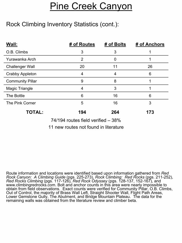
Route information and locations were identified based upon information gathered from Red Rock Canyon: A Climbing Guide (pgs. 225-273), Rock Climbing: Red Rocks (pgs. 211-252), Red Rocks Climbing (pgs. 117-126), Red Rock Odyssey (pgs. 128-137, 152-167), and www.climbingredrocks.com. Bolt and anchor counts in this area were nearly impossible to obtain from field observations. Exact counts were verified for Community Pillar, O.B. Climbs, Out of Control, the majority of Brass Wall Left, Straight Shooter Wall, Flight Path Areas, Lower Gemstone Gully, The Abutment, and Bridge Mountain Plateau. The data for the remaining walls was obtained from the literature review and climber beta.
Rock Climbing Inventory Statistics (cont.):
Wall: # of Routes # of Bolts # of AnchorsO.B. Climbs 3 3 1
Yurawanka Arch 2 0 1
Challenger Wall 20 11 26
Crabby Appleton 4 4 6
Community Pillar 9 8 1
Magic Triangle 4 3 1
The Bottle 6 16 6
74/194 routes field verified – 38%11 new routes not found in literature
The Pink Corner 5 16 3
TOTAL: 194 264 173
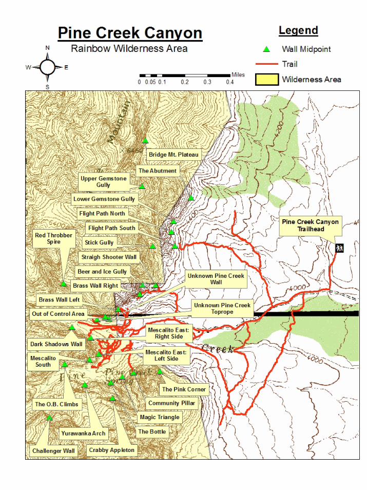
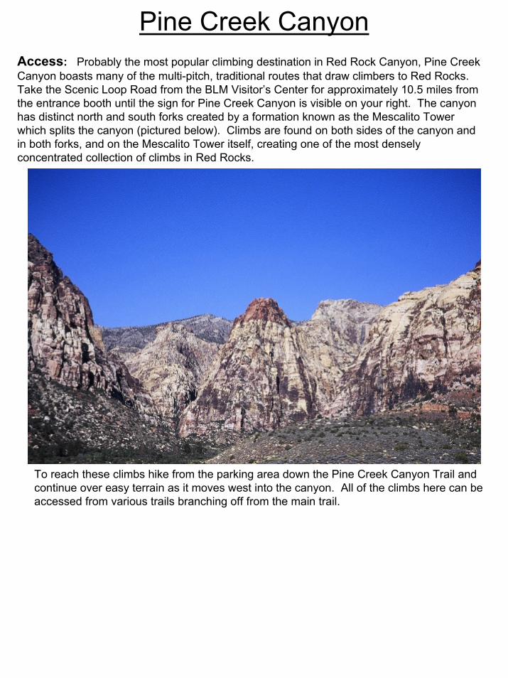
Pine Creek CanyonAccess: Probably the most popular climbing destination in Red Rock Canyon, Pine Creek Canyon boasts many of the multi-pitch, traditional routes that draw climbers to Red Rocks. Take the Scenic Loop Road from the BLM Visitor’s Center for approximately 10.5 miles from the entrance booth until the sign for Pine Creek Canyon is visible on your right. The canyon has distinct north and south forks created by a formation known as the Mescalito Tower which splits the canyon (pictured below). Climbs are found on both sides of the canyon and in both forks, and on the Mescalito Tower itself, creating one of the most densely concentrated collection of climbs in Red Rocks.
To reach these climbs hike from the parking area down the Pine Creek Canyon Trail and continue over easy terrain as it moves west into the canyon. All of the climbs here can be accessed from various trails branching off from the main trail.

Access (cont.): The climbs on Bridge Mountain’s south side (Bridge Mountain Plateau, The Abutment, Upper and Lower Gemstone Gullies, Flight Path Area and Stick Gully) are accessed by turning right (north) on the Dale Trail approximately 0.5 miles from the parking area. Hike north on the Dale Trail until an access trail branches off to the left and heads west up the slope to the base of the cliffs.
Straight Shooter Wall, Beer and Ice Gully, and the Brass Walls are on the north side of Pine Creek Canyon before it splits into two forks. Hike into the canyon until a newly restored access trail branches north approximately 1 mile from the parking area. This takes you to the base of Straight Shooter Wall. From there you can traverse left (west) along the base of the cliff to reach Beer and Ice Gully and Brass Wall Right. Brass Wall Left is accessed by continuing into Pine Creek Canyon on the main trail until it reaches the Mescalito Tower. Continue on the main trail as it moves into the north fork and becomes heavily braided. Braided access trails will split off to the right and take you to the base of the climbs.
Further into the north fork of Pine Creek Canyon is the Out of Control Area and two unknown walls on the north side of the canyon. On the south side is the popular Dark Shadows Wall that climbs the north side of the Mescalito Tower. Deeper into the north fork of Pine Creek Canyon is the Red Throbber Spire in the Northeast Pine Creek area. The north fork continues on for another mile or so before coming to an abrupt end at the massive Pisces Wall.
The Mescalito Tower has climbs on its east face divided into left and right sides. They are easily accessed by hiking into Pine Creek Canyon until it splits into two forks and taking heavily braided trails to the base of the tower. Braided trails also take you into the south fork of Pine Creek Canyon and around to the Mescalito Tower South Face. Further up the south fork on the north side of the canyon are the O.B. Climbs. Directly across from the O.B. Climbs on the south side of the canyon is the Yurawanka Arch. These areas are reached by hiking the south fork trail and scrambling to the base of the walls.
At the back of the south fork of Pine Creek Canyon, high up on the south side, is the large, red Challenger Wall. Moderate scrambling is required to reach this wall. Further to the east is the Crabby Appleton Area, also on the south side of the canyon. Involved scrambling through a narrow gully filled with boulders is required to reach this area.
The Community Pillar, Magic Triangle, and Bottle areas are all located on the south side of Pine Creek Canyon before it is split by the Mescalito Tower. Hike the main Pine Creek Canyon Trail until you are directly across from the Brass Wall. Take a steep, braided trail left (south) up the slope of the canyon until you reach the base of The Community Pillar. Traverse west from there to reach the Magic Triangle and Bottle areas.
The Pink Corner is the final climbing area in Pine Creek Canyon. It is to the east of The Community Pillar at the base of the escarpment making up Pine Creek Canyon’s south side. Hike the main trail into Pine Creek Canyon until you reach the old homesteader’s foundation. Turn left and follow the Arnight Trail south a short distance toward a low red band of rock to the east of the Pink Corner. Leave the Arnight Trail and scramble up the slope and right to the base of the climbs.
Pine Creek Canyon
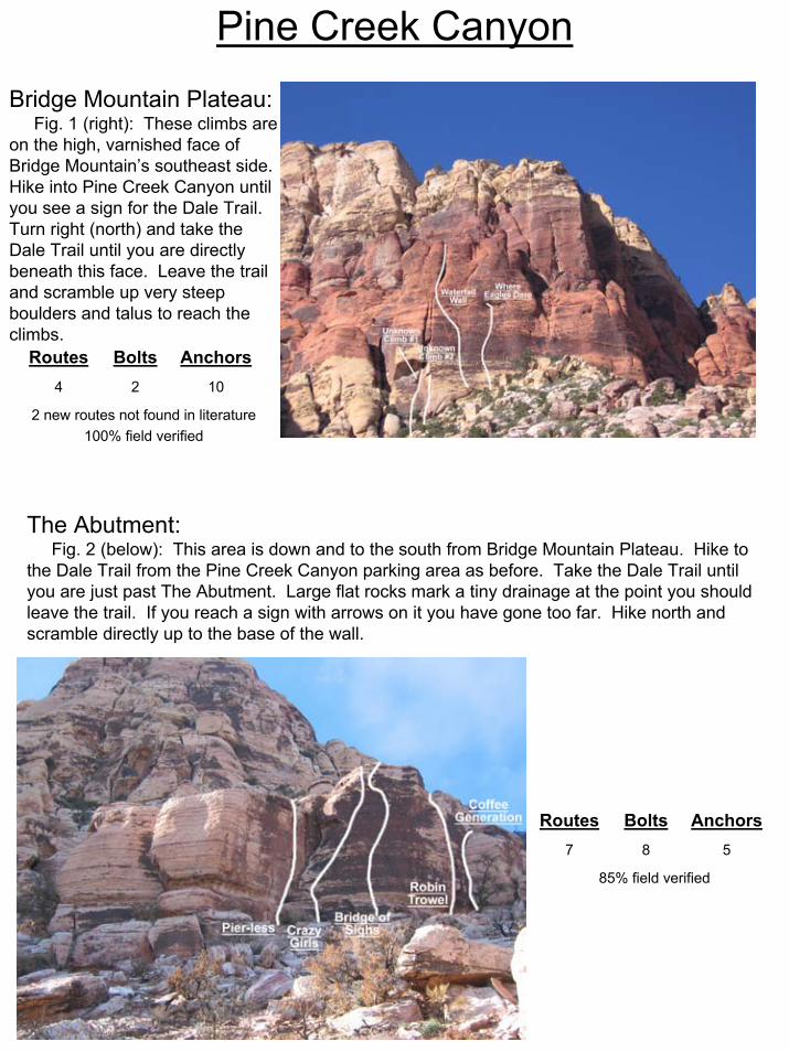
Pine Creek CanyonBridge Mountain Plateau:
Fig. 1 (right): These climbs are on the high, varnished face of Bridge Mountain’s southeast side. Hike into Pine Creek Canyon until you see a sign for the Dale Trail. Turn right (north) and take the Dale Trail until you are directly beneath this face. Leave the trail and scramble up very steep boulders and talus to reach the climbs.
The Abutment:Fig. 2 (below): This area is down and to the south from Bridge Mountain Plateau. Hike to
the Dale Trail from the Pine Creek Canyon parking area as before. Take the Dale Trail until you are just past The Abutment. Large flat rocks mark a tiny drainage at the point you should leave the trail. If you reach a sign with arrows on it you have gone too far. Hike north and scramble directly up to the base of the wall.
85% field verified
587
AnchorsBoltsRoutes
2 new routes not found in literature100% field verified
1024
AnchorsBoltsRoutes

Pine Creek CanyonLower Gemstone Gully :
Fig. 1 (right): Approach as for The Abutment described above. Once on the Dale Trail look for a park bench and a sign for Skull Rock. Hike directly uphill from there toward a large smile feature high on the cliff face. This is Upper Gemstone Gully (not pictured) and is accessed via 5th class climbing from Bridge Mountain Plateau. The base of the cliff is Lower Gemstone Gully pictured to the right. This area is also easily reached by skirting the base of the cliff from The Abutment or Flight Path Areas.
Flight Path Area:Fig. 2 & 3 (left/below): The Flight Path Area is
divided into North (right) and South (above) Walls. Access them by hiking from the Pine Creek Canyon parking area to the Dale Trail. Hike north on the Dale Trail approximately 300 yards before encountering a faint path leading northwest up the slope. Follow cairns to the base of Flight Path Area South, then traverse right along the base of the cliff to reach Flight Path Area North.
1 new route not found in literature100% field verified
264
AnchorsBoltsRoutes
78% field verified
72514
AnchorsBoltsRoutes

Pine Creek CanyonStick Gully:
Fig. 1 (below/left): Approach as if going to the Flight Path Area via the Dale Trail. Once at the base of the cliff move left (southwest) around the base of the escarpment until you reach the gully pictured here. Climbs are located roughly 200 yards up the gully on both sides. This area can also be accessed from the west by traversing the base of the cliff from Straight Shooter Wall.
Straight Shooter Wall:
Fig. 2 (right): The Straight Shooter Wall is easily accessed by a newly restored trail thanks to the efforts of the Climber’s Liaison Council. Hike the Pine Creek Trail from the parking area for roughly one mile until you reach a newly refurbished trail heading north toward the base of the cliff.
0% field verified
205
AnchorsBoltsRoutes
100% field verified
4158
AnchorsBoltsRoutes
Pine Creek Canyon
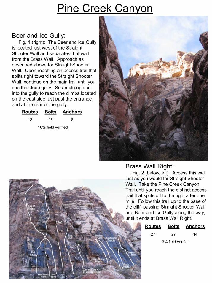
Beer and Ice Gully:Fig. 1 (right): The Beer and Ice Gully
is located just west of the Straight Shooter Wall and separates that wall from the Brass Wall. Approach as described above for Straight Shooter Wall. Upon reaching an access trail that splits right toward the Straight Shooter Wall, continue on the main trail until you see this deep gully. Scramble up and into the gully to reach the climbs located on the east side just past the entrance and at the rear of the gully.
Brass Wall Right:Fig. 2 (below/left): Access this wall
just as you would for Straight Shooter Wall. Take the Pine Creek Canyon Trail until you reach the distinct access trail that splits off to the right after one mile. Follow this trail up to the base of the cliff, passing Straight Shooter Wall and Beer and Ice Gully along the way, until it ends at Brass Wall Right.
16% field verified
82512
AnchorsBoltsRoutes
3% field verified
142727
AnchorsBoltsRoutes
Pine Creek CanyonBrass Wall Left:
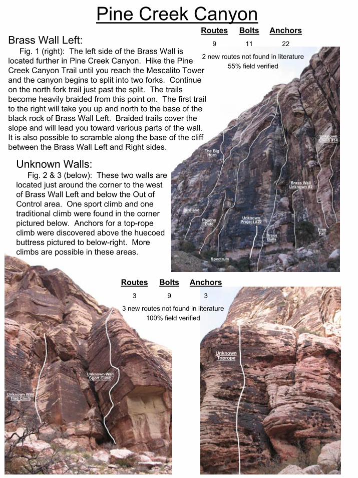
Fig. 1 (right): The left side of the Brass Wall is located further in Pine Creek Canyon. Hike the Pine Creek Canyon Trail until you reach the Mescalito Tower and the canyon begins to split into two forks. Continue on the north fork trail just past the split. The trails become heavily braided from this point on. The first trail to the right will take you up and north to the base of the black rock of Brass Wall Left. Braided trails cover the slope and will lead you toward various parts of the wall. It is also possible to scramble along the base of the cliff between the Brass Wall Left and Right sides.
Unknown Walls:Fig. 2 & 3 (below): These two walls are
located just around the corner to the west of Brass Wall Left and below the Out of Control area. One sport climb and one traditional climb were found in the corner pictured below. Anchors for a top-rope climb were discovered above the huecoed buttress pictured to below-right. More climbs are possible in these areas.
2 new routes not found in literature55% field verified
22119
AnchorsBoltsRoutes
3 new routes not found in literature100% field verified
393
AnchorsBoltsRoutes
Pine Creek Canyon
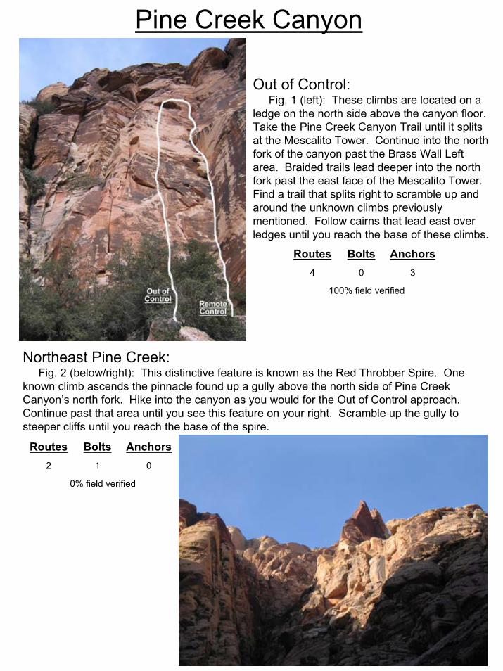
Out of Control:Fig. 1 (left): These climbs are located on a
ledge on the north side above the canyon floor. Take the Pine Creek Canyon Trail until it splits at the Mescalito Tower. Continue into the north fork of the canyon past the Brass Wall Left area. Braided trails lead deeper into the north fork past the east face of the Mescalito Tower. Find a trail that splits right to scramble up and around the unknown climbs previously mentioned. Follow cairns that lead east over ledges until you reach the base of these climbs.
Northeast Pine Creek:Fig. 2 (below/right): This distinctive feature is known as the Red Throbber Spire. One
known climb ascends the pinnacle found up a gully above the north side of Pine Creek Canyon’s north fork. Hike into the canyon as you would for the Out of Control approach. Continue past that area until you see this feature on your right. Scramble up the gully to steeper cliffs until you reach the base of the spire.
100% field verified
304
AnchorsBoltsRoutes
0% field verified
012
AnchorsBoltsRoutes
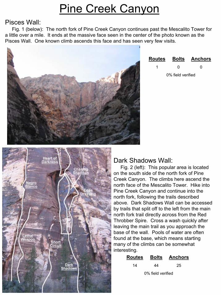
Pine Creek CanyonPisces Wall:
Fig. 1 (below): The north fork of Pine Creek Canyon continues past the Mescalito Tower for a little over a mile. It ends at the massive face seen in the center of the photo known as the Pisces Wall. One known climb ascends this face and has seen very few visits.
Dark Shadows Wall:Fig. 2 (left): This popular area is located
on the south side of the north fork of Pine Creek Canyon. The climbs here ascend the north face of the Mescalito Tower. Hike into Pine Creek Canyon and continue into the north fork, following the trails described above. Dark Shadows Wall can be accessed by trails that split off to the left from the main north fork trail directly across from the Red Throbber Spire. Cross a wash quickly after leaving the main trail as you approach the base of the wall. Pools of water are often found at the base, which means starting many of the climbs can be somewhat interesting.
0% field verified
001
AnchorsBoltsRoutes
0% field verified
254414
AnchorsBoltsRoutes

Pine Creek CanyonMescalito East Face – Right Side:
Fig. 1 (left): The Mescalito Tower is a prominent formation that splits Pine Creek Canyon into north and south forks. The East Face of this formation is split into northeast (right) and southeast (left) facing areas. The climbs on the right side of the face are immediately east of Dark Shadows Wall. Hike the Pine Creek Canyon Trail until you reach the Mescalito Tower. A heavily braided network of trails accesses the East Face of the Tower. Either hike directly toward the East Face from the main trail or continue into the north fork of the canyon. Follow braided trails that quickly split from the main trail to the left and cross a wash before heading toward the northeast face of the Mescalito Tower.
Mescalito East Face – Left Side:
Fig. 2 (right): The left side of the Mescalito East Face is directly south of the right side. The two parts of the face are separated by the white pillar seen in both pictures. A heavily braided network of trails covers the area leading up to both the left and right sides of the face. Access various climbs using this trail network.
0% field verified
132111
AnchorsBoltsRoutes
0% field verified
6410
AnchorsBoltsRoutes
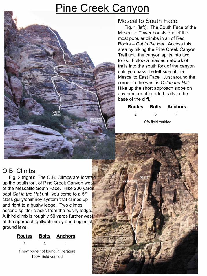
Pine Creek CanyonMescalito South Face:
Fig. 1 (left): The South Face of the Mescalito Tower boasts one of the most popular climbs in all of Red Rocks – Cat in the Hat. Access this area by hiking the Pine Creek Canyon Trail until the canyon splits into two forks. Follow a braided network of trails into the south fork of the canyon until you pass the left side of the Mescalito East Face. Just around the corner to the west is Cat in the Hat. Hike up the short approach slope on any number of braided trails to the base of the cliff.
O.B. Climbs:Fig. 2 (right): The O.B. Climbs are located
up the south fork of Pine Creek Canyon west of the Mescalito South Face. Hike 200 yards past Cat in the Hat until you come to a 5th
class gully/chimney system that climbs up and right to a bushy ledge. Two climbs ascend splitter cracks from the bushy ledge. A third climb is roughly 50 yards further west of the approach gully/chimney and begins at ground level.
0% field verified
452
AnchorsBoltsRoutes
1 new route not found in literature100% field verified
133
AnchorsBoltsRoutes
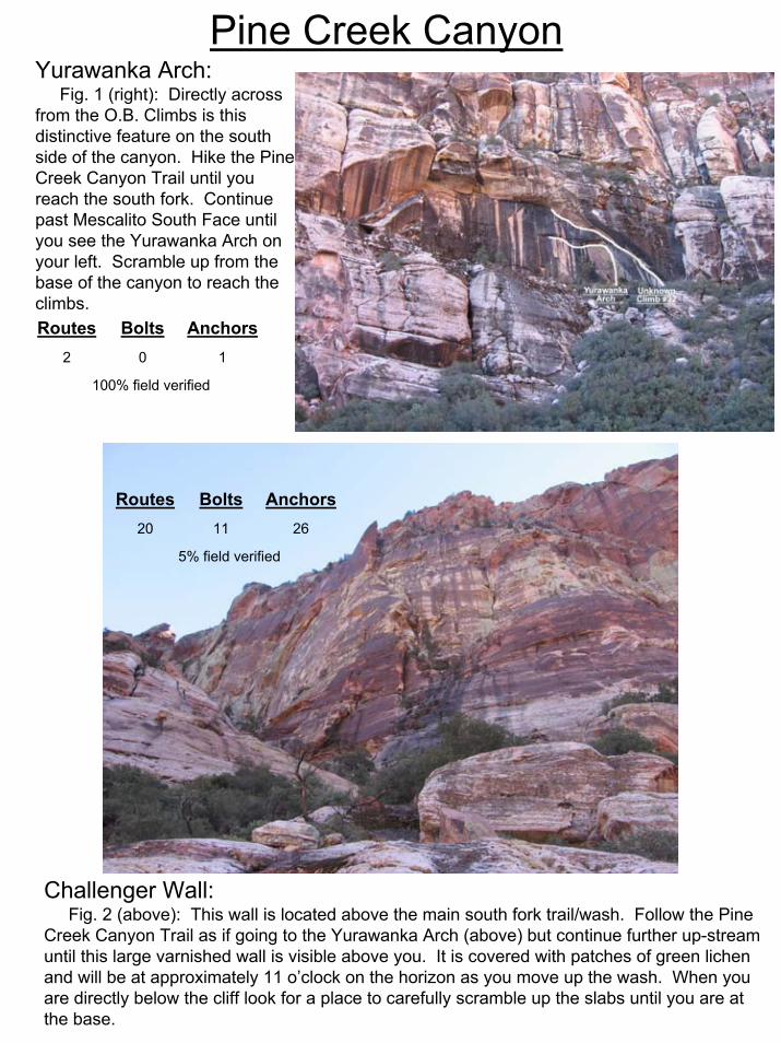
Pine Creek CanyonYurawanka Arch:
Fig. 1 (right): Directly across from the O.B. Climbs is this distinctive feature on the south side of the canyon. Hike the Pine Creek Canyon Trail until you reach the south fork. Continue past Mescalito South Face until you see the Yurawanka Arch on your left. Scramble up from the base of the canyon to reach the climbs.
Challenger Wall:Fig. 2 (above): This wall is located above the main south fork trail/wash. Follow the Pine
Creek Canyon Trail as if going to the Yurawanka Arch (above) but continue further up-stream until this large varnished wall is visible above you. It is covered with patches of green lichen and will be at approximately 11 o’clock on the horizon as you move up the wash. When you are directly below the cliff look for a place to carefully scramble up the slabs until you are at the base.
100% field verified
102
AnchorsBoltsRoutes
5% field verified
261120
AnchorsBoltsRoutes
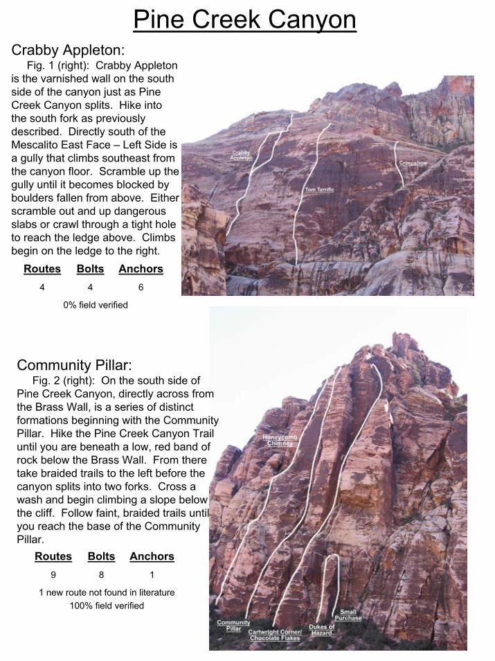
Pine Creek CanyonCrabby Appleton:
Fig. 1 (right): Crabby Appleton is the varnished wall on the south side of the canyon just as Pine Creek Canyon splits. Hike into the south fork as previously described. Directly south of the Mescalito East Face – Left Side is a gully that climbs southeast from the canyon floor. Scramble up the gully until it becomes blocked by boulders fallen from above. Either scramble out and up dangerous slabs or crawl through a tight hole to reach the ledge above. Climbs begin on the ledge to the right.
Community Pillar:Fig. 2 (right): On the south side of
Pine Creek Canyon, directly across from the Brass Wall, is a series of distinct formations beginning with the Community Pillar. Hike the Pine Creek Canyon Trail until you are beneath a low, red band of rock below the Brass Wall. From there take braided trails to the left before the canyon splits into two forks. Cross a wash and begin climbing a slope below the cliff. Follow faint, braided trails until you reach the base of the Community Pillar.
0% field verified
644
AnchorsBoltsRoutes
1 new route not found in literature100% field verified
189
AnchorsBoltsRoutes
Pine Creek Canyon
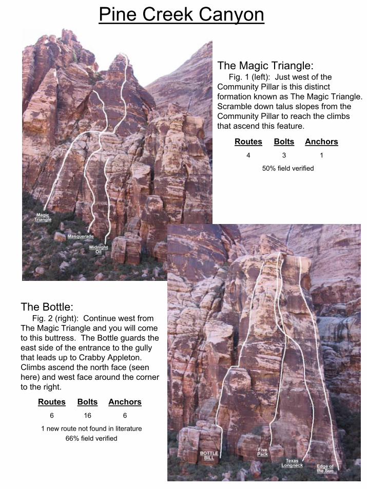
The Magic Triangle:Fig. 1 (left): Just west of the
Community Pillar is this distinct formation known as The Magic Triangle. Scramble down talus slopes from the Community Pillar to reach the climbs that ascend this feature.
The Bottle:Fig. 2 (right): Continue west from
The Magic Triangle and you will come to this buttress. The Bottle guards the east side of the entrance to the gully that leads up to Crabby Appleton. Climbs ascend the north face (seen here) and west face around the corner to the right.
50% field verified
134
AnchorsBoltsRoutes
1 new route not found in literature66% field verified
6166
AnchorsBoltsRoutes
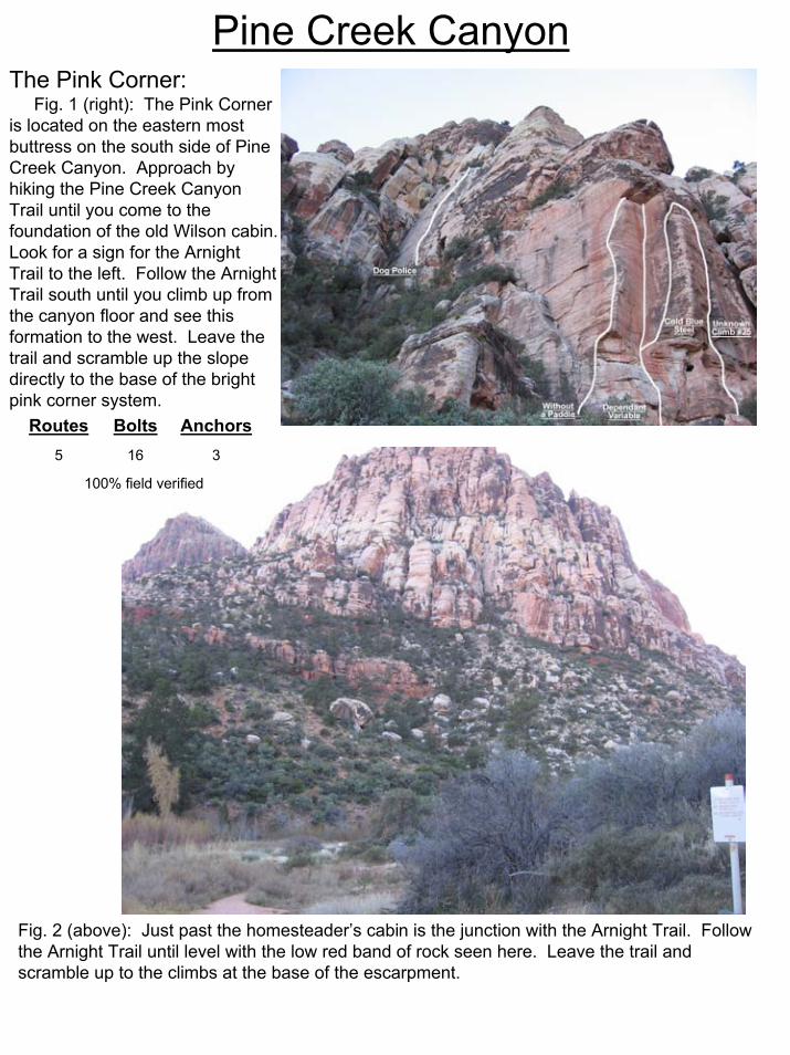
Pine Creek CanyonThe Pink Corner:
Fig. 1 (right): The Pink Corner is located on the eastern most buttress on the south side of Pine Creek Canyon. Approach by hiking the Pine Creek Canyon Trail until you come to the foundation of the old Wilson cabin. Look for a sign for the Arnight Trail to the left. Follow the Arnight Trail south until you climb up from the canyon floor and see this formation to the west. Leave the trail and scramble up the slope directly to the base of the bright pink corner system.
Fig. 2 (above): Just past the homesteader’s cabin is the junction with the Arnight Trail. Follow the Arnight Trail until level with the low red band of rock seen here. Leave the trail and scramble up to the climbs at the base of the escarpment.
100% field verified
3165
AnchorsBoltsRoutes
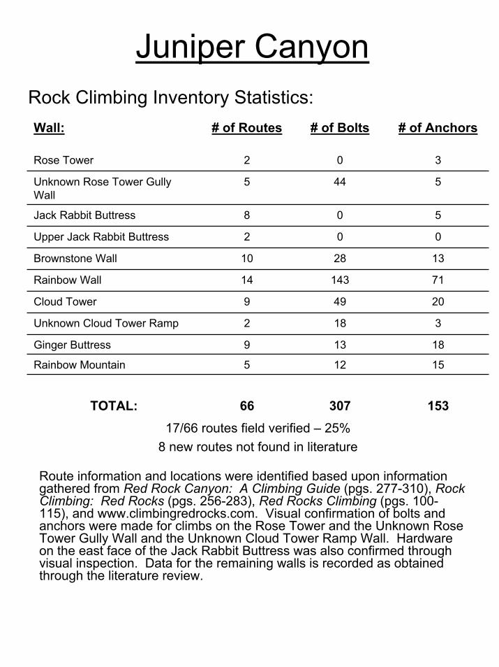
Juniper Canyon
Route information and locations were identified based upon information gathered from Red Rock Canyon: A Climbing Guide (pgs. 277-310), Rock Climbing: Red Rocks (pgs. 256-283), Red Rocks Climbing (pgs. 100-115), and www.climbingredrocks.com. Visual confirmation of bolts and anchors were made for climbs on the Rose Tower and the Unknown Rose Tower Gully Wall and the Unknown Cloud Tower Ramp Wall. Hardware on the east face of the Jack Rabbit Buttress was also confirmed through visual inspection. Data for the remaining walls is recorded as obtained through the literature review.
Wall: # of Routes # of Bolts # of Anchors
Rose Tower 2 0 3
Unknown Rose Tower Gully Wall
5 44 5
Jack Rabbit Buttress 8 0 5
Upper Jack Rabbit Buttress 2 0 0
Brownstone Wall 10 28 13
Rainbow Wall 14 143 71
Cloud Tower 9 49 20
Unknown Cloud Tower Ramp 2 18 3
Ginger Buttress 9 13 18
Rainbow Mountain 5 12 15
17/66 routes field verified – 25%8 new routes not found in literature
TOTAL: 66 307 153
Rock Climbing Inventory Statistics:
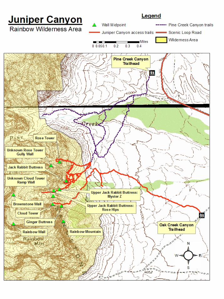
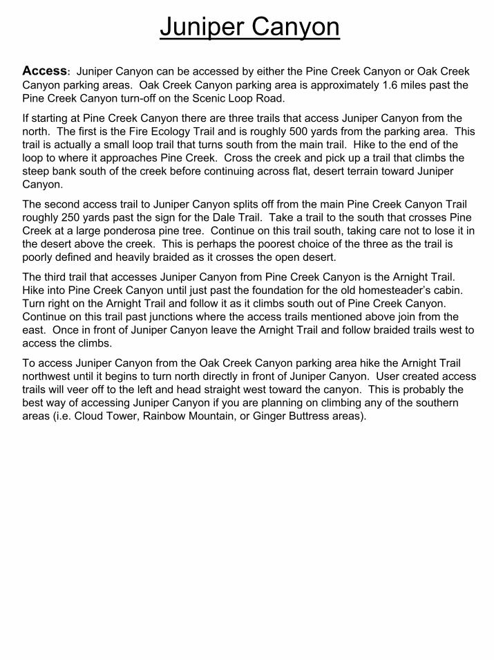
Juniper CanyonAccess: Juniper Canyon can be accessed by either the Pine Creek Canyon or Oak Creek Canyon parking areas. Oak Creek Canyon parking area is approximately 1.6 miles past the Pine Creek Canyon turn-off on the Scenic Loop Road.
If starting at Pine Creek Canyon there are three trails that access Juniper Canyon from the north. The first is the Fire Ecology Trail and is roughly 500 yards from the parking area. This trail is actually a small loop trail that turns south from the main trail. Hike to the end of the loop to where it approaches Pine Creek. Cross the creek and pick up a trail that climbs the steep bank south of the creek before continuing across flat, desert terrain toward Juniper Canyon.
The second access trail to Juniper Canyon splits off from the main Pine Creek Canyon Trail roughly 250 yards past the sign for the Dale Trail. Take a trail to the south that crosses Pine Creek at a large ponderosa pine tree. Continue on this trail south, taking care not to lose it in the desert above the creek. This is perhaps the poorest choice of the three as the trail is poorly defined and heavily braided as it crosses the open desert.
The third trail that accesses Juniper Canyon from Pine Creek Canyon is the Arnight Trail. Hike into Pine Creek Canyon until just past the foundation for the old homesteader’s cabin. Turn right on the Arnight Trail and follow it as it climbs south out of Pine Creek Canyon. Continue on this trail past junctions where the access trails mentioned above join from the east. Once in front of Juniper Canyon leave the Arnight Trail and follow braided trails west to access the climbs.
To access Juniper Canyon from the Oak Creek Canyon parking area hike the Arnight Trail northwest until it begins to turn north directly in front of Juniper Canyon. User created access trails will veer off to the left and head straight west toward the canyon. This is probably the best way of accessing Juniper Canyon if you are planning on climbing any of the southern areas (i.e. Cloud Tower, Rainbow Mountain, or Ginger Buttress areas).
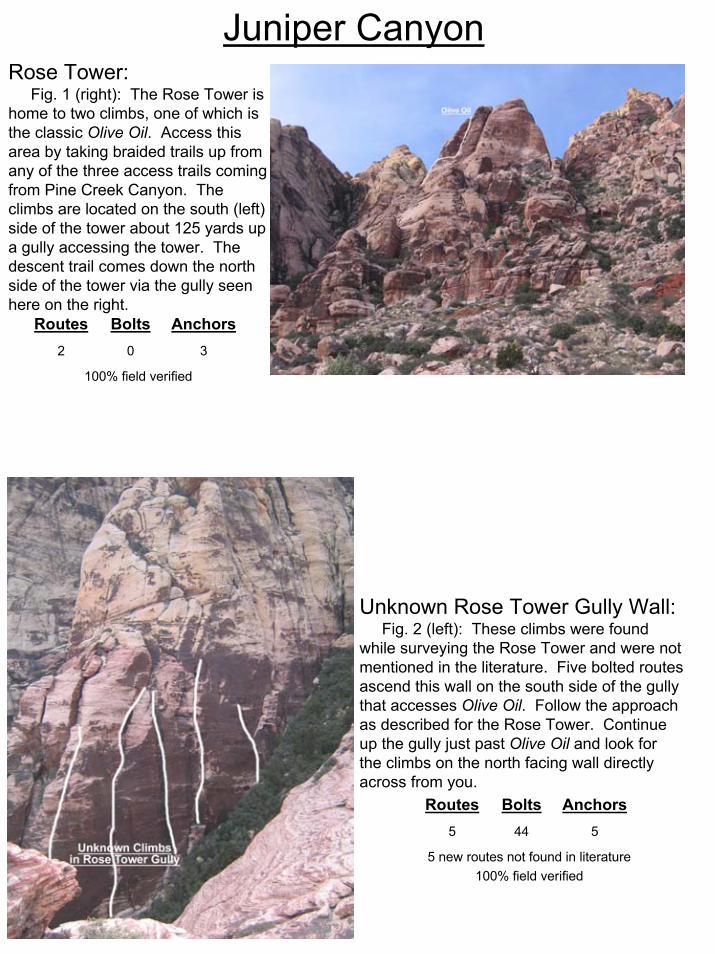
Juniper CanyonRose Tower:
Fig. 1 (right): The Rose Tower is home to two climbs, one of which is the classic Olive Oil. Access this area by taking braided trails up from any of the three access trails coming from Pine Creek Canyon. The climbs are located on the south (left) side of the tower about 125 yards up a gully accessing the tower. The descent trail comes down the north side of the tower via the gully seen here on the right.
Unknown Rose Tower Gully Wall:Fig. 2 (left): These climbs were found
while surveying the Rose Tower and were not mentioned in the literature. Five bolted routes ascend this wall on the south side of the gully that accesses Olive Oil. Follow the approach as described for the Rose Tower. Continue up the gully just past Olive Oil and look for the climbs on the north facing wall directly across from you.
100% field verified
302
AnchorsBoltsRoutes
5 new routes not found in literature100% field verified
5445
AnchorsBoltsRoutes
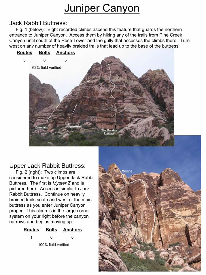
Juniper CanyonJack Rabbit Buttress:
Fig. 1 (below): Eight recorded climbs ascend this feature that guards the northern entrance to Juniper Canyon. Access them by hiking any of the trails from Pine Creek Canyon until south of the Rose Tower and the gully that accesses the climbs there. Turn west on any number of heavily braided trails that lead up to the base of the buttress.
Upper Jack Rabbit Buttress:Fig. 2 (right): Two climbs are
considered to make up Upper Jack Rabbit Buttress. The first is Myster Z and is pictured here. Access is similar to Jack Rabbit Buttress. Continue on heavily braided trails south and west of the main buttress as you enter Juniper Canyon proper. This climb is in the large corner system on your right before the canyon narrows and begins moving up.
62% field verified
508
AnchorsBoltsRoutes
100% field verified
001
AnchorsBoltsRoutes
Juniper Canyon
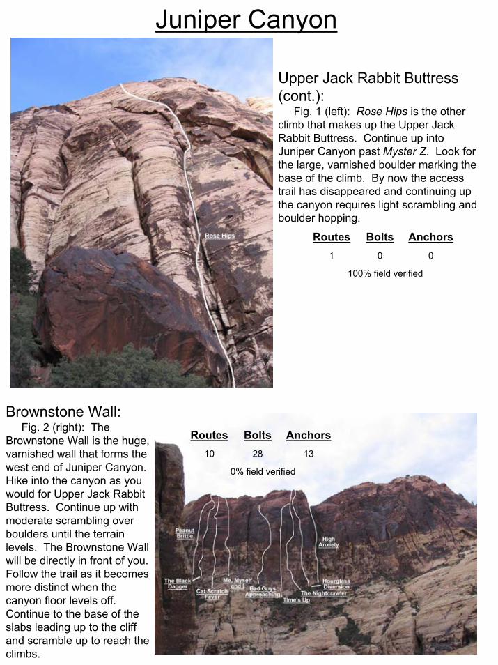
Upper Jack Rabbit Buttress (cont.):
Fig. 1 (left): Rose Hips is the other climb that makes up the Upper Jack Rabbit Buttress. Continue up into Juniper Canyon past Myster Z. Look for the large, varnished boulder marking the base of the climb. By now the access trail has disappeared and continuing up the canyon requires light scrambling and boulder hopping.
Brownstone Wall:Fig. 2 (right): The
Brownstone Wall is the huge, varnished wall that forms the west end of Juniper Canyon. Hike into the canyon as you would for Upper Jack Rabbit Buttress. Continue up with moderate scrambling over boulders until the terrain levels. The Brownstone Wall will be directly in front of you. Follow the trail as it becomes more distinct when the canyon floor levels off. Continue to the base of the slabs leading up to the cliff and scramble up to reach the climbs.
100% field verified
001
AnchorsBoltsRoutes
0% field verified
132810
AnchorsBoltsRoutes

Juniper CanyonRainbow Wall:
Fig. 1 (below): This beautifully colored wall is on the north side of Rainbow Mountain and towers over Juniper Canyon to the south. Approach as if going to the Brownstone wall. Soon after the ground levels off and the trail reappears you will see a large pine tree. A path leads right toward the Brownstone Wall. Move left toward large, white slabs following cairns along the floor of a wash. When the wash terminates climb the fixed line hand-over-hand to reach the top of the slabs. Scramble 200 – 300 yards over easy slabs until you reach the base of the wall.
Cloud Tower:Fig. 3 (left): This prominent buttress guards
the southern side of the entrance to Juniper Canyon. The Red Rocks classic Crimson Chrysalis ascends the middle of the pillar in the center of the photo. Routes are best accessed by hiking the Arnight Trail from the Oak Creek Canyon parking area. Braided trails branch left and head west and south toward the Cloud Tower at just under a mile. Follow the trail to the base of the ramp seen in the foreground. Scramble/hike up to the base of the climbs.
Fig. 2 (below): Ascending the fixed line to reach the approach slabs to the Rainbow Wall.
0% field verified
7114314
AnchorsBoltsRoutes
0% field verified
20499
AnchorsBoltsRoutes
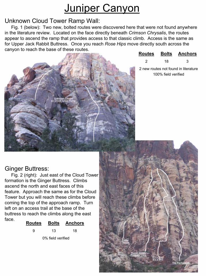
Juniper CanyonUnknown Cloud Tower Ramp Wall:
Fig. 1 (below): Two new, bolted routes were discovered here that were not found anywhere in the literature review. Located on the face directly beneath Crimson Chrysalis, the routes appear to ascend the ramp that provides access to that classic climb. Access is the same as for Upper Jack Rabbit Buttress. Once you reach Rose Hips move directly south across the canyon to reach the base of these routes.
Ginger Buttress:Fig. 2 (right): Just east of the Cloud Tower
formation is the Ginger Buttress. Climbs ascend the north and east faces of this feature. Approach the same as for the Cloud Tower but you will reach these climbs before coming the top of the approach ramp. Turn left on an access trail at the base of the buttress to reach the climbs along the east face.
2 new routes not found in literature100% field verified
3182
AnchorsBoltsRoutes
0% field verified
18139
AnchorsBoltsRoutes
Juniper Canyon
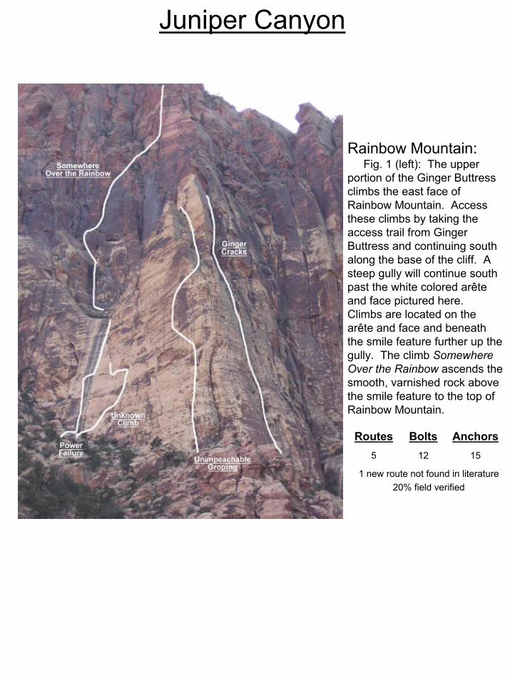
Rainbow Mountain:Fig. 1 (left): The upper
portion of the Ginger Buttress climbs the east face of Rainbow Mountain. Access these climbs by taking the access trail from Ginger Buttress and continuing south along the base of the cliff. A steep gully will continue south past the white colored arête and face pictured here. Climbs are located on the arête and face and beneath the smile feature further up the gully. The climb Somewhere Over the Rainbow ascends the smooth, varnished rock above the smile feature to the top of Rainbow Mountain.
1 new route not found in literature20% field verified
15125
AnchorsBoltsRoutes