romanian journal of mineral deposits - utm.rnu.tn fileromanian journal of mineral deposits -...
TRANSCRIPT

Romanian Journal of
MINERAL DEPOSITS
continuation of
DARI DE SEAMA ALE SEDINTELOR INSTITUTULUI DE GEOLOGIE SI GEOFIZICA
COMPTES RENDUS DES SÉANCES DE L’INSTITUT DE GÉOLOGIE ET GÉOPHYSIQUE
(2. Zacaminte)
Founded 1910 by the Geological Institute of Romania
ISSN 1220-5648 VOL. 87 No. 2
Geological Institute of Romania
Society of Economic Geology of Romania
Bucureşti – 2014
CONTENT
Valerian CIOBOTARU, Aurelia POPUIAC
Crystalline formations in central region of the Dniester River Basin ……………………….....…..…............. 1
Essaïd BILAL, Elena Luisa IATAN, Moussa BOUNAHKLA, Fernando Machado MELLO, Marc
DOUMAS, Issam GUENOLE-BILAL, Mounia TAHRI, Frédéric GALLICE,
Didier GRAILLOT, Herve PIEGAY
The metallic contamination impact on freshwater mussels Anodontes at the
Saint-Victor-sur-Loire lake, France ……….……………...…………………………………………................ 5
Mihai MARINESCU, Gunter TIESS, Mihai MAFTEIU
Surface mining of the Romanian mineral and power resources, in all times ……….……………...…............ 9
Daniela CRISTEA-STAN, Bogdan CONSTANTINESCU, Imre KOVÁCS,
Zoltan SZŐKEFALVI-NAGY
Geological sources for archaeological obsidian found in Romania …………………………………............... 15
Antonela NEACŞU, Gheorghe C. POPESCU
Fourier-transform infrared spectroscopy (FT-IR) and X-ray diffractometry (XRD) as methods
for discriminating amber and amber-like materials from the Romanian market …………………..…............ 19
Mircea-Ionuţ PETRESCU, Horia ISPAS, Marin MUŞU-COMAN
Industrial diamond application in cutting ornamental rocks ………………………………………................. 23
Gabriela-Silviana MARICA, Octavian COLȚOI
Aggregates planning – towards a new vision of mineral resources ………………………………….............. 27
Valentina CETEAN, Mihai MARINESCU
Updated inventory of mineral non-metalliferous and non-combustible raw materials
exploitations or perimeters in Bihor county ...................................................................................................... 31
Mustafa YILDIZ, Ahmet YILDIZ, Asuman KAHYA, Sevgi GÜRCAN
Geology of Kizilkaya (Sevinçli / Aksaray) ignımbrıte and investıgatıon of the usage as
buldıng stone (Turkey) ...................................................................................................... ................................ 35
- continued on the back cover -
DIRECTORS
Dr. Marcel Mărunțiu, General Director of the Geological Institute of Romania
Prof. Dr. Gheorghe Damian, President of the Society of Economic Geology of Romania
Editor in Chief: Sorin Silviu Udubaşa (University of Bucharest).
Editorial Secretary: Monica Macovei (University of Bucharest)
Editorial board
Gheorghe Udubaşa, Romanian Academy; University
of Bucharest
Gheorghe Popescu, University of Bucharest,
Essaid Bilal, Ecole des Mines, Saint Etienne, France
Georgios Christofides, Aristotle University of
Thessaloniki, Greece
Peter Andráš, Geological Institute of the Slovak
Academy of Science
Radu Jude, University of Bucharest
Gheorghe Damian, Technical Univ. Cluj-Napoca –
North Center Baia Mare,
Floarea Damian, Technical Univ. Cluj-Napoca –
North Center Baia Mare
Grigore Buia, University of Petrosani
Marian Lupulescu, New York State Museum, USA
János Földessy, Miskolc University, Hungary
Ovidiu Gabriel Iancu, "Alexandru Ioan Cuza"
University, Iaşi
Anne-Sylvie Andre-Mayer, Université de Lorraine,
Nancy, France
Ferenc Molnar, Geological Survey of Finland
M.S. Pandian, Pondicherry University, India
Vasilios Melfos, Aristotle University of Thessaloniki,
Greece
Gheorghe Ilinca, University of Bucharest
Mihai Marinescu, University of Bucharest
Marcel Mărunţiu, Geological Institute of Romania,
Bucharest
Ioan Pintea, Geological Institute of Romania
Mircea Ţicleanu, Geological Institute of Romania,
Bucharest
Nicolae Buzgar, "Alexandru Ioan Cuza" University,
Iaşi
Marian Munteanu, Geological Institute of Romania
Ioan Seghedi, Institute of Geodynamics of the
Romanian Academy, Bucharest
Dan Stumbea, "Alexandru Ioan Cuza" University, Iaşi
Sorin Silviu Udubașa, University of Bucharest
Antonela Neacsu, University of Bucharest
Călin Tămaş, Babeş-Bolyai University, Cluj-Napoca
George Tudor, Geological Institute of Romania,
Bucharest
Rom . J. Mineral Deposits is also the Bulletin of the Society of Economic Geology of Romania
The authors are responsible for the ideas presented in the papers.
ISSN 1220-5648

i
Geological Institute of Romania
Society of Economic Geology of Romania
Romanian Journal of
MINERAL DEPOSITS
ISSN 1220-5648 VOL. 87 / 2014 No. 2
Volume dedicated to Univ. Prof. Dr. Gheorghe C. Popescu
(Honorary President of SGER)
on the occasion of his 75th
Anniversary
CONTENT
Valerian CIOBOTARU, Aurelia POPUIAC
Crystalline formations in central region of the Dniester River Basin ……………………….....…..... 1
Essaïd BILAL, Elena Luisa IATAN, Moussa BOUNAHKLA, Fernando Machado MELLO,
Marc DOUMAS, Issam GUENOLE-BILAL, Mounia TAHRI, Frédéric GALLICE,
Didier GRAILLOT, Herve PIEGAY
The metallic contamination impact on freshwater mussels Anodontes at the
Saint-Victor-sur-Loire lake, France ……….……………...………………………………………….. 5
Mihai MARINESCU, Gunter TIESS, Mihai MAFTEIU
Surface mining of the Romanian mineral and power resources, in all times ……….……………..... 9
Daniela CRISTEA-STAN, Bogdan CONSTANTINESCU, Imre KOVÁCS,
Zoltan SZŐKEFALVI-NAGY
Geological sources for archaeological obsidian found in Romania …………………………………. 15
Antonela NEACŞU, Gheorghe C. POPESCU
Fourier-transform infrared spectroscopy (FT-IR) and X-ray diffractometry (XRD) as methods
for discriminating amber and amber-like materials from the Romanian market …………………..... 19
Mircea-Ionuţ PETRESCU, Horia ISPAS, Marin MUŞU-COMAN
Industrial diamond application in cutting ornamental rocks ……………………………………….... 23
Gabriela-Silviana MARICA, Octavian COLȚOI
Aggregates planning – towards a new vision of mineral resources …………………………………. 27
Valentina CETEAN, Mihai MARINESCU
Updated inventory of mineral non-metalliferous and non-combustible raw materials
exploitations or perimeters in Bihor county ....................................................................................... 31
Mustafa YILDIZ, Ahmet YILDIZ, Asuman KAHYA, Sevgi GÜRCAN
Geology of Kizilkaya (Sevinçli / Aksaray) ignımbrıte and investıgatıon of the usage as
buldıng stone (Turkey) ....................................................................................................................... 35

ii
Adolf Heinrich HORN, Hernando BAGGIO, Rafaelle SCHIMITH
Selected element distribution in bottom sediment samples from Três Marias Lake
and its significance, Minas Gerais, Brazil ........................................................................................... 39
Adolf Heinrich HORN, Igo Fernando LEPSCH, Regynaldo Arruda SAMPAIO, Márcio
Neves RODRIGUES, Anarelly Costa ALVARENGA, Ely Sandra Alves de OLIVEIRA
Heavy metals and aluminum content inside silicophytoliths from Ricinus communis,
Andropogon arundinaceus and Brachiaria decumbens grown on soils added with
sewage sludge and heavy metal salts (Brazil) …………………………………………………….…. 43
Hernando BAGGIO, Heinrich HORN, Thiago MARTINS, Matheus SIMÕES
Rainfalls and natural disasters: the 2011 - 2012 events in Minas Gerais State - Brazil ……………... 47
Najla LASSOUED, Mohamed Naceur KHELIL, Saloua REJEB, Essaid BILAL,
Mohamed CHAOUACHI, Mohamed Néjib REJEB
Incidence of sewage sludge fertilizer application on Ray Grass (Morocco) …………………..…...... 51
Fernando Machado de MELLO, Rômulo MACHADO, Essaid BILAL
Predisposing factors for shallow landslides susceptibility in southeastern Rio de Janeiro, Brazil ….. 55
Márcia Andréia da SILVA NUNES, Adolf Heinrich HORN, William Fortes RODRIGUÊS,
Essaid BILAL
Environmental conditions on the eastern part of the Caparaó Range National Parc and its
sourroundings, Espírito Santo State, Brazil ………………………………………………………….. 61
Ahmed TOUIL, Mohamed HIBTI, Essaid BILAL, Abdessamad EL KHALILE
Chemistry of minerals from the Azegour skarn deposits, western High Atlas, Morocco ………….... 67
Alexandre Sylvio Vieira DA COSTA, Adolf Heinrich HORN
The use of dimension stone cut residual in agriculture soil correction. An example from
Espirito Santo State, Brazil …………………………………………………………………….…….. 71
Alexandre Sylvio Vieira DA COSTA, Adolf Heinrich HORN, Amando de Pinho AGUIAR
Changes in the P-concentration in brazilian soils after aplication of waste material
from dimension stone production, Brazil …………………………………………………………..... 75
Alexandre Sylvio Vieira DA COSTA, Adolf Heinrich HORN, Amando de Pinho AGUIAR
Uso reaction products of battery acid from cars and cellulose waste from industry as a
new fertilizer for corn cultivation (Zea mays l.) on poor soils, on an example from
Governador Valadares in Minas Gerais, Brazil ................................................................................... 79
Ines GALFATI, Essaid BILAL, Hassan ABDALLAH, Aicha BEJI SASSI
Geochemistry of solid effluents and phosphate ore washed from Métlaoui-Gafsa Basin, Tunisia ..... 83
Denisa JIANU, Răzvan ORZA, Cezar IACOB, Lucian PETRESCU, Virgil IORDACHE,
Aurora NEAGOE, Julieta RUSU
The potential hazard induced by heavy metal contamination related to tailings ponds. Case study:
Pîrâul Cailor tailing pond (Suceava County, Romania) …………...................................................... 87
Iulia NEGREA, Daniela DIMOFTE, Gheorghe C. POPESCU
Preliminary data regarding sands heavy minerals from the Levee Letea (Danube Delta) ….............. 91
Cătălina CIORTESCU, Gabriel O. IANCU, Ion SANDU, Viorica VASILACHE
Geochemistry of titanium heavy minerals in stream sediments from the Bistrița Aurie River
(Romania) ……………………………………………………………………………………...…….. 97
Marian Marius CHICOȘ, Gheorghe DAMIAN, Dan STUMBEA
Preliminary data on the geochemistry of the Străjii Valley tailing pond (Suceava County, Romania) 101
Aurora Măruţa IANCU, Delia Georgeta DUMITRAŞ, Ştefan MARINCEA, Essaid BILAL,
Cristina GHINEŢ, Maria Angela ANASON
Determination of phosphogypsum from Romania by SEM-EDAX …………………………………. 105

Rom. J. Mineral Deposits, vol. 87 (2014), No. 2, p. 1-4
1
CRYSTALLINE FORMATIONS IN CENTRAL REGION OF THE DNIESTER RIVER BASIN
Valerian CIOBOTARU1*
, Aurelia POPUIAC2
1 Institute of Geology and Seismology of Academy of Science of Moldova, 60/3 Gh. Asachi Street, MD 2028,
Chişinău, Republic of Moldova, *
[email protected]; 2 Moldova State University, Department of Soil Sciences, Geography, Geology, Forestry and Design; Specialty
Geology, Chişinău, Republic of Moldova; [email protected].
Abstract: In the central region of the Dniester River Basin – the NNE part of the Republic of Moldova -
petrological studies have been carried out in order to detail the lithology of the crystalline rock complexes, to assess
their origin and the prospecting areas with possible ore accumulations. These crystalline rocks are Archean to early
Proterozoic in age and can be divided into several formations: Gneisses formation (upper Archean),
Enderbitesformation (upper Archean – early Proterozoic), Alaskites formation (early Proterozoic) Metasomatites
formation, Dinamomorfites formation. Concentrations of La and Ce have been detected, exceeding the geochemical
background. Probably significant accumulation of REE can be found in the basal layers of platform sedimentary
cover in detrital aureoles consisting of zircon and monazite - the main sources of REE in this area.
Keywords: metamorphism, ultrametamorphism, metasomatism, geological formations, zircon, monazite, REE.
I. Introduction
During the second half of the last century, in the north-east of the Republic of Moldova, the study
of the structure and geological evolution of the crystalline formations, covered by a much younger
complex sedimentary cover were carried out (Geru, 1987). Economically, this study solves the problem of
location in space of the areas most promising for precious metals deposits, REE, radioactive elements and
zirconium (Lvina, 1972).
The study of the crystalline successions, mostly Archean and early Proterozoic, that make up the
basement of the investigated area, poses many difficulties, being a permanent subject of debate. The
formations of the crystalline basement from the middle part of the Dniester River are constituted of rocks
composed largely of variable ratios of the same minerals; therefore, their stratigraphic sequence is often
arbitrary. For example, some metamorphic varieties can be separated only based on auxiliary criteria:
accesory minerals, presence or absence of specific geochemical aureole, petrophysical properties etc.
Other rocks, frequently found in zones of metasomatic processes also have similar features.
II. Geological background
The study of the crystalline rocks, in most cases of Archean and early Proterozoic age, located in
the crystalline basement, was and remains a difficult problem and presents a topic of permanent
discussion. Crystalline basement formations from central region of Dniester River basin are constituted of
rocks with almost similar mineralogical composition, and, on this account, stratigraphic sequence can be
tackled in an arbitrary way. For example, some metamorphic varieties differ from each other only on the
basis of auxiliary indexes - accessories mineralization, the presence or absence of specific geochemical
aureoles, petrophysical properties, etc. Other rocks, frequently found in the regions affected by
metasomatic processes, have similar characteristic features.
In the central region of the Dniester River basin, crystalline rocks of basement can be divided into
several formations, which differ from one another by petrographic compositions, age and origin: Gneisses
formation (upper Archean), Enderbites formation (upper Archean - lower Proterozoic), Alaskites
formation (lower Proterozoic) Metasomatites formation, Dinamomorfites formation (Zaharov et al.,
1987). The main geological - structural element in the north – eastern part of Republic of Moldova is
presented by Dniester Fault. In many publications, this area appears under the name of "Dniester
Aulacogen", which also emphasizes the structural graben aspect of this area.
III. Petrography
1. Gneisses formation. The most important feature of Gneisses formation is the polyfacial
character of all rock varieties and it is of note that the progressive and retrogressive metamorphic
processes throughout the area took place at different times.

2
The main minerals, usually biotite - pyroxene - amphibole – plagioclase, show broad variation of
their proportion in rocks; accessory minerals are represented by garnet, cordierite, apatite, zircon,
ilmenite, and magnetite.
The mineralogical and chemical composition of the rocks from gneisses formation corresponds
with metamorphic rocks with a low content of SiO2 (crystalline schist) and rocks containing normal or
saturated with SiO2 (gneisses).
2. Enderbites formation. Some researchers include the enderbites in a general formation known
as the charnockites formation (Dmitrov, 1977). Local geologists, examining enderbites only in relation
with the rocks rich in sodium, highlight enderbites formation as an independent unit.
Specific features of the enderbites formation in Dniester River region are:
- Presence only in early Precambrian formations;
- Associative relations with crystalline schists or hypersthene gneisses;
- Structural relations concordant with host rocks (crystalline schists and gneisses);
- Variable mineralogical composition, characterized by broad modal variation of each individual
component;
- Various grain size; variability of structures and textures, some of which are specific of igneous rocks.
In the central zone of the Dniester River basin the enderbites formation contains the following
rocks: enderbites (including cordierite enderbites) plagiogranite (biotite, with garnet, with cordierite),
plagiomigmatite (biotite, pyroxene, with garnet, with cordierite), plagiopegmatite (including
plagiopegmatite with hypersthene), pyroxenite and pyroxene amphibolite, gabbronorite. These are
genetically related to the earliest metamorphic formations, are characterized by a relatively high sodium
content (Na2O 4,3-5,4%), have specific structural features and textural and mineral associations of
different origins and ages.
In terms of mineralogical composition, the rocks in the enderbites formation are quite varied, but
all have relatively high concentrations of plagioclase with oligoclase to andesine compositions (An25-40),
which makes up most of the rock mass. Beside hypersthene, in rare occasions, another monoclinic
pyroxene may be present - green diopside with pale shade, which practically makes it difficult to
distinguish from hypersthene in hand specimens.
Separate bands enriched in accessory minerals (magnetite and apatite), are present together with
chlorite and biotite in areas with poor cohesion between plagioclase and quartz crystals or in rock
fissures. Magnetite has the average content of about 3000 g / t, and apatite – the average is approximately
500 g / t; other accessory minerals (garnet, monazite and zircon) are present in small quantities. At the
same time, in some biotite - plagiogranite, the concentration of zircon is 331 g / t, monazite - 211 g / t,
garnet - 20 759 g / t. Some rocks of the formation contain ilmenite in relatively low concentrations.
3. Alaskites formation. Rock varieties of alaskites formation - alaskites, leucogranites, and
granodiorites (pure or garnet-bearing) are most commonly found in the Dniester river basin region in
comparison with other formations of crystalline basement; they form quite thick sequences. Alaskite
bodies are relatively diverse and are represented by veins, lenses, thin inclusions in gneiss or
charnockitoides, zones with xenoliths of older rocks or extended zones homogeneous in terms of their
petrography. Some pegmatoides or metasomatic rocks are also present in the alaskite formation.
The place of alaskites formation in he sequence o the crystalline basement is determined by
geological processes in the final stages of cratonization, which manifested by ultrametamorphism of
earliest rocks from gneisses formation and of relatively young rock of enderbites formation.
Simultaneously, a silicic - potassic metasomatism process took place, which have led to the formation of
microcline granite varieties.
In the rocks of the alaskite formation, the paragenetic associations are relatively simple and differ
from one another only in general mutual relations (structural and quantitative) of the main minerals -
potassium feldspars (microcline) and plagioclases (An20 -30, lacking polysynthetic twinning). Rocks with
garnet and cordierite also occur in this formation. Apart from alaskites – leucogranites, some rocks of
pneumatolitic - metasomatic origin were identified as pegmatoides.
Unlike enderbites, in alaskites, the quartz is present in two modifications - "foreign" quartz
brought from other areas of the background, and quartz deposited during granitoids formation.
Most rocks of the alaskite formation are distinguished by their typical porphyroblasts.
Porphyroblasts composed of plagioclase and microcline occur in a fine-grained mass with feldspathic

3
composition. At the same time, some varieties of alaskites are distinguished by hypidiomorphic granular
structure.
In terms of chemical composition, the rocks of the alaskites formation are relatively
homogeneous. High concentrations of SiO2 in rocks: 74 % alaskite, 72 % leucogranite, and 71% in
migmatite is explained by the action of silica flux brought from other areas of the underground.
If we compare the associations of accessory minerals of rocks from alaskites formation with the
gneisses and enderbites formations we find the same assemblages consisting of magnetite, zircon,
monazite, apatite and garnet. Zircon and monazite concentrations in granitoids formation can be quite
high. In some varieties is observed a high concentration of garnet, which can become a major mineral. It
is possible that the accessory minerals are not genetically related to their actual host rocks, being inherited
from some protoliths.
Most varieties of crystalline rocks in alaskites formation composition contain magnetite; its
relatively high concentrations were detected in some wells and due to metasomatic processes occurred in
the final stages of formation establishment.
4. Metasomatites and dinamomorfites formations. The regions of metasomatic processes in the
central region of the Dniester river basin related to disjunctive tectonics orientated to the north-west and
north-east directions or with some geological boundaries, which demarcate the rock formations. These
rocks are located mostly in tectonic areas with weak cohesion; metasomatites are in spatial correlation
with dinamomorfites; often metasomatic rocks and dinamomorfites are indivisible.
Majority of metasomatic formations are characterized by a complex zonality, reflecting a regular
event of the process. Since the beginning is formed specific products of iron - magnesium metasomatism,
then potassium, and in the final stages - silica. Usually, in the final stage of metasomatism enriching
material space with quartz and simultaneously, reduces the concentration of accessories minerals in the
rock.
Because of the complex mineralogical composition, metasomatites systematization poses many
difficulties. All granitization cycles that took place in the slope region of Ukrainian Crystalline Shield,
including the middle zone of Dniester River basin, were achieved by a metasomatic process that
introduced plagioclase in the composition of enderbites formationand pegmatiods in alaskites formation.
In active tectonic regions, during long geological periods, metasomatites are in genetic relations
with tectonic breccia, cataclasites and milonites from faults zones; called by many geologists rocks of
dynamic stress, highlighting the variety of stress granite, stress enderbite, etc. (Geru, 1987). Injection of
high-temperature fluid solutions in falling-out areas generated a very complex rocks variety. The
compositional variations of the metasomatites in those areas was induced by the combined effect of the
fluids and the composition of the original rocks.
A special feature of calcium - magnesium - iron metasomatism from the study area is manifested
by the formation of so-called calciphyre, in the composition of which, in addition to calcite ( 95%) are
also present pyroxenes.
IV Premises of prospecting for rare earth elements
In the research done by several generations of Moldavian geologists within the territory of the
Republic of Moldova, namely in the central region of the Dniester river basin - northern and north-eastern
part of the republic, in geological formations at depths of 50-400 m, mineralizations of zircon, monazite,
xenotime and coffinite were detected. Based on spectrographic analysis in different petrologic varieties of
the crystalline basement and terrigenous layers situated in the deposit directly on the aureoles of REE of
the crystalline basement,, with quite high concentrations were determined. Thus, in granitoides of
alaskites maximum concentrations of Lanthanum reach about 120 g / t and Cerium - 80 g / t.
The local sedimentary concentration of REE, significantly exceeding their contents in the source
rocks, is related to the presence of monazite and zircon. Remarking the high correlation coefficient
between zircon and monazite (ρ = 0.73), and satisfactory degree of correlation (η = 8.6> 3) (Popuiac,
2013), we can assume that these two minerals, in terms of geology, are syngenetic, and probably, as
accessory minerals, were formed simultaneously in the same petrologic formation (Zaharov et al., 1987).
At the same time, analyzing mineralogical data of the crystalline formations mentioned above, it is
determined that monazite, unlikezircon, occurs later in the sequence, i.e. zircon is present in practically all
rock types, including those of Archean age, while monazite occurs in rocks of early Proterozoic age.
4
REE concentrations in crystalline rocks, are generally insignificant. According to some
researchers, relatively high concentrations of these elements, which would present a practical interest,
can be found in the basal layers of platform sedimentary cover, where were discovered relatively high
amounts of monazite( from 5.0 to 10.2 kg / t) and zircon (from 4.9 to 13.4 kg / t), products of the
disintegration of the crystalline basement rocks. In almost all mineralogical samples, a fairly stable
relation was observed, with zircon concentration exceeding monazite concentration. Nevertheless, the
results of the spectrographic analyses, showed that the REE in the monazite fraction may be higher than
in the zircon fraction. In areas with significant zircon and monazite mineralization, the concentrations of
cerium and lanthanum (CLa + Ce) determined based on spectrographic analyzes, can be up to 0.2%
(Popuiac, 2013).
V. Discussions and conclusions
Several researchers consider that the metamorphic rocks of gneisses formation are derived from basic
volcanic protoliths, montmorillonite and vermiculite clays genetically related to the mafic volcanics and
some subordinate quantities of polymictic and grauwacke sandstones. On the basis of the existing
theoretical concepts it is assumed that the paragenetic association commonly found in the gneisses
formation was generated at temperatures of about 600-750 C under the conditions of overburden
pressure of about 4 to 8.5 kbar (Zaharov et al., 1987). At the same time, the rocks in the gneisses
formation can be seen as raw material for the rocks generated by later ultrametamorphic processes.
Probably, because of their refractory behavior, the accessory minerals were inherited without significant
changes from their source rocks. This is supported by the geochronological research data conducted by
Ukrainian geologists. In the south-west slope regions of Ukrainian Crystalline Shield - neighboring area
of Dniester river basin - zircon age found in the Archean, early Proterozoic and late Proterozoic
formations is practically one and the same, of about 3000 million years.
It is not excluded that metasomatic processes in the Dniester basin region, according to regional tectonic
evolution, were produced repeatedly.
Being established in the early Archean, the portion of the crust studied here ended its tectonic
evolution approximately at the beginning of the early Proterozoic. Probably, during that period, in this
zone, magmatic processes were accompanied by horizontal and vertical movements of the basement,
which led to the formation of the Dniester graben, poorly outlined because of a series of transverse faults.
The tectonic features of the basement have influenced the sedimentogenesis processes that took place in
the Riphean and early Vendian, and the basal layers, consisting of terrigenous lithological varieties, are
almost entirely correlated with the petrographic composition of the basement, reflecting the mineralogy of
the the most elevated paleomorphologic structure of the basement. This explains the relatively great
thickness of sedimentary layers along the Dniester fault and, most important, the generation, in some
places, of detrital aureoles rich in monazite and zircon, which are reflected gochemically by REE
geochemical anomalies, especially rich in Lanthanum and Cerium.
References
Dmitrov G.H. (1977). Charnockites Formation of central region of the Bug River basin. IGFM, Kiev. (in
Russian)
Geru M. I. (1987). Precambrian evolution of Moldova. Science, Chisinau. (in Russian)
Lvina D. (1972). The geological report on the distribution particularity of the non-ferrous, rare, and rare
earth elements in Precambrian formations from the North Moldova. AGRM funds, Chisinau. (in
Russian)
Popuiac A. (2013). Localization of geochemical aureoles of rare earths in the northern region of Republic
of Moldova. In: Horizons in Earth Sciences Research, Volume 10, Nova Science Publishers, Inc.
New York, USA.
Zaharov А., Sergheev C., Ciobotaru V., (1987). The geological report on the geological structure and
useful mineral deposits in mining-industrial region Rezina. AGRM funds, Chisinau. (in Russian).

Rom. J. Mineral Deposits, vol. 87 (2014), No. 2, p. 5-8
5
THE METALLIC CONTAMINATION IMPACT ON FRESHWATER MUSSELS ANODONTES
AT THE SAINT-VICTOR-SUR-LOIRE LAKE, FRANCE
Essaïd BILAL1, Elena Luisa IATAN
1,2, Moussa BOUNAHKLA
3, Fernando Machado MELLO
4,
Marc DOUMAS1, Issam GUENOLE-BILAL
5, Mounia TAHRI
2, Frédéric GALLICE
1,
Didier GRAILLOT1, Herve PIEGAY
6
1. Ecole Nationale Supérieure des Mines, Géosciences & Environnement Département, CNRS:UMR5600, F-42023
Saint Etienne, France ([email protected]).
2. Institute of Geodynamics "Sabba S. Stefanescu" of Romanian Academy, Bucharest ([email protected]).
3. Nuclear Centre of Energies, Sciences and Nuclear Techniques (CNESTEN), B.P. 1382, R.P. 10001, Rabat,
Morocco
4. Agronomic Institute, Universidade Federal Rural do Rio de Janeiro, Brazil (UFRRJ) ([email protected])
5. Département de Physiologie, Université de Lausanne-CHUV, Lausanne, Suisse ([email protected])
6. UMR 5600 EVS / Site ENS de Lyon 69342 Lyon, France ([email protected])
Abstract: Saint Etienne (France) has a large industrial and mining history. The end of these activities has given way
to industrial wasteland and mine dumps. Leaching caused by rain, industrial and mining waste may generate a very
large urban pollution. Rivers (Ondaine and Loire) and lakes (Saint-Victor-sur-Loire) downstream of this zone are
highly polluted by heavy metals. The study has focused freshwater mussels to determine the risk of water pollution.
We have shown that freshwater mussels are a good bioindicator for monitoring over time, this type of water
pollution due to their ability to filter water from the river. The entire food chain (freshwater mussels, mollusk,
shrimp, fish, birds and humans) is affected by the pollution.
Keywords: freshwater mussels; heavy metals; bioaccumulation; bioindicator.
1. INTRODUCTION
Due to their industrial and mining history, several agglomerations in the Rhône-Alpes region have
mining and industrial wastes containing several metals pollution sources of groundwater, public health
and urban management problem of some sites.
The study of pollution of the Saint-Victor-sur-Loire Lake lacks. Indeed, considering the difficulty of the
collection of valid samples for trace metal analysis in water as well as the low spatial and temporal
representativeness of these, the use of the quantitative bioindicators of the chemical contamination attracts
more and more attention in ecotoxicology.
We have elaborated this work to estimate the degree of the metal contamination at the level of the Saint
-Victor-sur-Loire Lake and Ondaine river mouth this by dosage of seven trace metals (Cu, Mn, Fe, Co, Cr, Pb
and Cd) in freshwater Anodontes mussels. In fact, freshwater mussels have been found to be suitable
indicator species for trace metals (Goldberg, 1975; Phillips, 1976; Phillips, 1977; Brown & Luoma, 1995;
Jumshamn & Grahl-Nielsen, 1996). It is capable to accumulate trace metals such as cadmium, mercury and
lead to a larger extent than for example fish and algae (Jumshamn & Grahl-Nielsen, 1996; Riget et al., 1996;
Airas et al., 2004).
2. CONTEXT
Saint Victor Lake is bordered by two castles; it is a reservoir of 66 million m3 of volume, 3.65 km
2
surface, built in 1957. Decennial drains in 1977, 1987 and 2000 were not performed. They were
conducted between 2011 and 2012. Saint Victor Lake is located downstream of Aurec-sur-Loire (Haute-
Loire) and upstream of Saint-Just-Saint-Rambert (Loire). The density of carp is low but includes catfish,
crayfish and mussels. In March 1995, the volume of sludge deposited at Ondaine mouth was estimated at
40 000 m3. The cost of sludge removal was evaluated then at € 2 million. The total volume of sludge
deposited across the Grangent dam was between 1.5 and 2 million m3, which represents 1.3 Mt. Two-
thirds of the sediment would have been deposited by the Loire River and a third by tributaries (primarily
Ondaine). Among the sediments, there were found metal oxides in significant quantities. The thickness of
the sediment was about 5 meters at the confluence of Ondaine-Loire. Water quality is still a major
problem for the Saint Victor Lake. Indeed, during the heart of the great industrial period, Ondaine brought
20,000 tonnes of materials such as iron, manganese, zinc and nickel.
Ondaine is an affluent of the Loire River, crossing several small towns. The Ondaine River itself
has several tributaries: The Cotatay has long time been renowned for the quality of its waters. Twenty-
two ancient factories located on its shores, ended their industrial activity. The Egotay’s Ondaine tributary
was also renowned for the quality of its waters. Many laundresses and Unieux washerwomen were

6
washing their line basins using its waters. Since the late 1960, the quality of rivers has deteriorated. In
November 2002, the Egotay was still receiving Charles’s area wastewater and the ones of Beaulieu town,
located in the town of Roche-la-Molière, and domestic discharges of Bécizieux, the small town of Saint-
Victor-sur-Loire via a collector of sewage and other agricultural and industrial untreated waste. The first
traces of pollution of the Gampille tributary of the Ondaine were identified in 1964. In 1989, the Agency
of Loire-Brittany Basin is committed to the Department of the Haute-Loire to stop the pollution problems
of the Gampille and its tributary Combobert, caused by the waste disposal of Saint-Just-Malmont and the
malfunction of the treatment plant.
The causes of "historic" pollution of the Ondaine river have many origins: Industrialization of the
valley, receives, without any treatment, waste waters from many industrial plants; tailing mine and
industrial waste; direct discharges of wastewater into the river; the small size of the watershed that
provides the preponderance of urban discharges during low flow periods and the excessive and
uncontrolled use of pesticides also contributes to the degradation of Ondaine and Loire water quality.
The mines are no longer operating in the Ondaine Valley since 1983. The basement of the valley
contains 304 galleries. Mine wastewater was pumped by the Charbonnages de France Company but
rejected in part on the bed of the Ondaine watercourse. The slag wastes are still important. The
management of these historical slag wastes still constitutes to be a major problem for the region. For 150
years, many companies operated production of special steels but dairy has accumulated in many slag
wastes. The sources of pollution of the river were still potentially important in 2003. Industrial equipment
is not completely waterproof. Wastes were sometimes stored near watercourses. A preliminary study by
Geosciences & Environment department of Ecole Nationale Supérieur des Mines de Saint Etienne of a
one hundred samples showed that the soils of the Ondaine valley are very rich in metal oxides, especially
those growing on industrial waste. Industrial waste and harvested soils are highly reactive (Figure 1) and
metal oxides are mobilized and easily pass into solution. Water filled metal oxides exceed safety
standards. Leaching tests conducted in the laboratory have shown that water charged resided 3-4 days,
depending on the location, before returning to the streams and Ondaine River.
Figure 1: Mo versus Cr content from slag, altered slag and soil of Ondaine valley.
2. METHODS AND MATERIALS
The sampling of freshwater mussels was elaborated at four stations belonging to the mouth of the
Ondaine estuary and Saint Victor Lake.
The shells were carefully opened so as not to damage the tissues. The samples were conserved in
sterilized petri dishes, weighed and stored at a temperature of -18 °C. The adopted procedure for the
preparation of mussels was as follows: lyophilization during 48 hours under vacuum and a temperature of
-50 °C, and under a pressure of about 4000 bar; grinding of each sample in a porcelain mortar until the
obtaining of a fine powder; Addition of 3 ml of concentrated HNO3 (69°C) in each bomb to solubilize the
metals and 1 ml of H2O2 to oxidize the organic matter and digestion at high pressure and high
temperature. Analyses of the final solutions were done for all trace elements detected by ICP-AES and
Atomic Absorption Spectroscopy in graphite furnace. The results are expressed in µg/g of dry weight
(ppm).
Scanning electron microscopy (SEM) coupled with energy dispersive spectroscopy (EDS).
Observations and elemental analyzes were performed on a scanning electron microscope Jeol JSM 6400
coupled to an Oxford EDS analyzer (ENSM-SE). Observations were carried out on secondary electrons
mode in the case of granular raw unpolished samples and backscattered electron mode. To obtain

7
comparable results, all analyzes were performed under identical conditions with an accelerating voltage
of 20 kV. Chemical analyzes are semi-quantitative. Mappings XR heavy metals helped to highlight their
distributions in mussel shells. Previously, samples were metallized with carbon or gold depending on the
type of observations and analyzes made.
3. RESULTS AND DISCUSSION
The organic portion of these freshwater mussels is richer in metals than the shell (Figure 2). The
freshwater mussels filter the water of the river and therefore concentrate metals in the organic part. Metal
concentrations are above the safety and health standards (Bilal, 2013). Ondaine Valley drains the major
part of the heavy metals that we find in freshwater mussels. The contents of heavy metals in both cases,
Loire River and at the mouth of Ondaine, are comparable. The same pattern is found in the freshwater
mussels of the Ribeira de Iguape River in Brazil and the freshwater mussels from Sebu River in Morocco.
The processes of accumulation in tissues are extremely complex and depend on several factors, including
the properties of the receiving tissue (Maury & Engrand, 1986); the nature of the contaminant and the
intra and extracellular environment (Bowen, 1966). Contrary to fishes, the organs of the freshwater
mussels are all exposed to chemical pollutants suspended in the water; direct contamination could have
the same significance as the trophic contamination.
Heavy metals are in relationship with different pollution incidents and continuous leaching of
industrial and mining waste. Mo, V and Co get to permanently control the composition of mussel’s shells.
Fe, Mn, Ni appear sporadically (Figure 3) and indicate an occasional pollution. The striations of these
shells show growth and it represents a very good bioindicator to monitor the pollution of water.
Figure 2: Distribution of metals in freshwater Andonata mussels at the Saint Victor Lake, Loire river (Shell1, organs
1), at the mouth of Ondaine, Shell 2 and organs 2 (Bilal, 2013) and freshwater mussels at the Ribeira de Iguape
River, organs RIR, Brazil (Rodrigues et al., 2013) and green: Organs from Sebou River Morocco (Bounakhla et al.,
2011) .
4. CONCLUSION
Understanding the phenomenon of bioaccumulation of heavy metals in living substance is of
extremely complex. This is due to the interpenetration of several parameters which influence the
bioaccumulation namely in general: the physico-chemical characteristics of the environment, the
chemical properties of the contaminant and the biologic factors of the organism. The freshwater mussels
are reliable as bioindicator and easy to use to track the evolution of water pollution.
This study showed that all measured heavy metals are higher than normally permitted levels and
reveal a health hazard for the population. Notably, Saint-Victor-sur-Loire Lake is a station where take
place a lot of nautical activities and swimming from spring to late summer.
In conclusion, the results of this study show the persistent degradation of the Ondaine Valley and
Loire River as a result of industrial, mining, agricultural and domestic discharges, which it would increase
if no strategy of protection of this environment by concerned authorities, is developed and implemented.
5. ACKNOWLEDGMENTS
Funding for this project was provided by a grant from the Conseil Régional de Rhone-Alpes and
Post-doc grant from CAPES/PNPD. The authors thank to Ecole Nationale Supérieure des Mines, the Unit
of Pollution and Geochemistry of CNESTEN for their technical support.

8
Figure 3: SEM image and heavy metals distribution in the shells of freshwater mussels by XR mapping (Bilal,
2013). Fe, V - yellow, Mn, Mo, Ni - white; Co, Cu - green and Zn - grey.
6. REFERENCES Airas S., Duinker A. & Julshamn K., 2004. Copper, zinc, arsenic, cadmium, mercury, and lead in blue mussels (Mytilus
edulis) in the Bergen harbor area, Western Norway. Bulletin of environmental contamination and toxicology,
73(2), 276-84.
Bilal E., 2013. Environment Hazards: The recharge areas of the Guarani Aquifer in the state of São Paulo and comparison
with the Loire and the Rhône basins in the Rhône-Alpes region. 1ST
International Research Workshop, 13 - 15
November 2013 Lyon, France.
Bounakhla, M., Bounakhla, Z., Tahri, M., Zahry, F., Zghaid M, Doukkali, A., Benkirane, O., Saidi, N., Bilal, E., 2011.
Evaluation of the Metallic Contamination Impact on 'Mytilus edulis' Mussel at the Level of the Mouth of Sebou's
Estuary, Marocco. Carpathian Journal of Earth and Environmental Sciences, September 2011, Vol. 6, No. 2, p. 219
– 214.
Bowen H.J.M., 1966. Trace elements in biochemistry. Academic Press, London. 241pp.
Brown C.L. & Luoma S.N., 1995. Use of the Euryhaline Bivalve Potamorcorbula Amurensis as a Biosentinel Species to
assess Trace Metal Contamination in San Francisco Bay. Marine Ecology Progress Series, 124, 129-142.
Goldberg E. D., 1975. The Mussel Watch- A first Step in Global Marine Monitoring. Marine Pollution Bulletin, 6, Issue 7,
111.
Julshamn K. & Grahl-Nielsen O., 1996. Distribution of Trace Elements from Industrial Discharges in the Hardangerfjord,
Norway: A Multivariate Data Analysis of Saithe, Flounder, and Blue Mussel as Sentinel Organisms. Marine
Pollution Bulletin, 32, 564-571.
Maury R. & Engrand P., 1986. Recherches en écotoxicologie expérimentale sur la bioaccumulation et les transferts de
mercure dans un système "sédiment-eau-macrophytes. M. S. thesis, University of Bordeaux 1, pp. 320.
Phillips D.J.H., 1976. The Common mussel Mytilus edulis as an Indicator of Pollution by Zinc, Cadmium, Lead and
Copper. II. Relationship of Metals in the Mussel to those Discharged by Industry. Journal of Marine Biology, 38,
71-80.
Phillips D.J.H., 1977. The Use of Biological Indicator Organisms to Monitor Trace Metal Pollution in Marine and
Estuarine Environments- a Review. Environmental Pollution Journal, 13, 281-311.
Riget F., Johansen P. & Asmund G., 1996. Influence of Length on Element Concentrations in Blue Mussels (Mytilus
edulis). Marine Pollution Bulletin, 32, 745-751.
Rodrigues V., Sigolo, J., Guimarães, E. (2013) Availability of metals in bottom sediments and freshwater bivalve
(Corbicula flumínea and Anondontites tenebricosus) – Ribeira de Iguape River Brazil. In Society for Environment
geochemistry and health Symposium, Paris 8-12 July 2013. P. 78.

Rom. J. Mineral Deposits, vol. 87 (2014), No. 2, p. 9-14
9
SURFACE MINING OF THE ROMANIAN MINERAL AND POWER
RESOURCES, IN ALL TIMES
Mihai MARINESCU1*
, Gunter TIESS2***
, Mihai MAFTEIU1**
1University of Bucharest, Geology and Geophysics Faculty; 6, Traian Vuia Str., 020956 Bucharest, Romania;
2University of Leoben, Leoben, Austria;
Abstract: During his entire history, in Romania, 82 mineral and power substances were exploited at the surface, in
over 3478 identified quarries and open pits. Exploitation period began timidly in the Primitive Commune. In
Antiquity, it was done at a moderate rate in the Dacian Kingdom period and at high level in the Roman Empire time.
Surface mining have regressed in first part of the Middle Ages (the migration period) but, in the second part, the
mineral resources exploitation grew. However, the biggest intensity of surface mining and mineral production, the
most numerous mineral resources (81), quarries and open pits (3,383) are observed in Modern Ages. In all times,
98,6 % (3427 quarries and open pits) from the identified surface exploitations had extracted 78 non-power mineral
resources and 1,4 % (51) had exploited 4 power resources. There were 3,301 non-metallic surface exploitations and
only 6 metallic mineral resources were exploited in 126 quarries. The non-renewable resources type (79 substances)
were extracted in very large quarries and open pits number: 2,390 (68.8 %).
Keywords: surface mining, Romanian surface mining, mineral resources exploitation, Romanian quarries,
Romanian open pits.
INTRODUCTION
Mineral and power resources are of fundamental importance for economic development of all countries.
Although Romania is not a big country, due to the very complex geological structure 110 mineral and
power substances have been identified and quantified as resources and reserves (Marinescu, 2003). In
time, the most numerous (82) from these substances were exploited at the ground surface (the statistics go
back to the year 2000).
Currently, Romania ranks 10th in the world in terms of the diversity of minerals produced in the country.
Around 60 different mineral commodities are produced in Romania (Taylor and Francis, 2007, from
Wikipedia). The surface mining is a very old occupation for our people and its real size is not properly
known. In time, this presentation must to be continuously improved, especially with new archaeological
data and old documents studies.
1. FAVOURABLE FACTORS FOR THE SURFACE MINING
Located between the latitude coordinates of 43°37’07" and 48°15’06" North and longitude coordinates of
20°15’44" and 29°41’24" East, Romania is an intersection point for commercial roads, from North to
South of the Europe and From East to West (Eurasian Steppe Route from Silk Road) but also to
numerous neighboring peoples. The country extends approximately 300 miles North to South and 400
miles East to West and have a surface of 237,500 km2. In time, the population was numerous, with a good
density, laborious, stable. On this territory, very old civilizations existed.
New archaeological discoveries on the Sibiu –Orăștie highway show 8,000 – 10,000 years old habitation.
The Tartaria tablets indicate the oldest writing in the world (7,300 years old). The Cucuteni Civilization
is 7,000 years old (some hundred years before the first localities in Sumer and Egypt), Boian Civilization
is 6,500 years old, Gumelnița Civilization is 6,000 years old, Hamangia Civilization is 5,500 – 6,000
years old. On the Romanian Territory, there was a non-intermittent civilization (population continuity on
5,000 years to present).
The economic development was uninterrupted in time but with increase and decrease periods. The relief
variety (mounts, hills, plaines and plateaus) and dense hydrographical network had permitted quarries,
respectively sand pit, gravel pit or ballast pit existence. The geological structure was mainly determined
by:
- many and different geo-structural units: Eastern Carpathians, Southern Carpathians, Apuseni
Mountains, Moldavian Platform, South-Dobrogean Platform, Central Dobrogean Massif, North-
Dobrogean Orogen, Transylvanian Depression, Pannonian Depression etc.
- long geological evolution in time, with many orogen cycles: pre-Assyntic, Assyntic, (Cadomian),
Caledonian, Hercynian (Variscan), Alpine;

10
- presence of 110 mineral and power substances, identified and quantified in resources and reserves; the
most numerous (82) of these were at the surface and at small depth.
2. SURFACES MINING ON HISTORIC EPOCHS
2.1. SURFACE MINING IN THE PRIMITIVE COMMUNE
Of course, the surface mining was practiced in primitive manner. Archaeological data indicate as certain
only 4 exploited mineral substances: firestone (extensively exploited but the archaeologists discovered
exploitations only at Bercea Mare, Leșnic and Roşcani), quartzite (Cernat Hill), limestone (Gura Văii),
sand and gravel (Ghioroc).
Surface mining was practiced in other numerous, but unknown today sites, especially firestone and
quartzite, on Dârjovului Valley, Oltului Valley, Dâmbovnicului Valley, Lupului Valley, Prutului Valley
(Marinescu, 2013).
2.2.SURFACE MINING IN THE ANTIQUITY
In the Dacian Kingdom period andesite quarries existed at Uroi Hill (Simeria town) and Pietroasa Hill (Deva city). Limestone quarries are known at Măgura Hill (on Streiului Valley), Călan and Ardeu. Sand was exploited in Ghenetea open pit. Gold was extracted from gold sands (in many unknown river exploitations) (Marinescu and Bogatu, 2005). Using andesite from Pietroasa Hill, the well known sanctuaries from the Sarmizegetusa Regia have been constructed. The archaeologists (Boroneant, 2000) speak about indeterminate rocks exploitations at Bejan Hill (near Deva city), Dugău Hill (Ionești), Făget and Grădiștea (Sf. Maria de Piatră) quarries. We think many of the remains of the Dacian quarries have disappeared because the exploitation have continued, with increased intensity, in Roman times. In Roman Empire period, the number of identified quarries and open pits is 53. Limestone quarries were
identified at Măgura Hill (Călan), Cărpiniș, Geoagiu, Peșteana, Strei (Călan), Valea Sângiorgiului
(Călan), Ampoița, Ighiu, Albești, Iablanița, Rușchița, Rusca Montană, Bahna, Gura Văii I, Gura Văii II,
Vâciorova and Dinogetia (Garvan). Large quantities of marble were extracted at Pârâului Valley (Cristur),
Rușchița and Rusca Montană (possible, Bucova as well). Andesite quarries are known at Petris-Uroi
(Simeria city), Pietroasa Hill and Pietroasa 2 (both near Deva city).
The andesite from Petris-Uroi was used for buildings from Ulpia Traiana Sarmizegetusa, Micia and other
roman localities (Boroneant, 2000). Sandstone was exploited in quarries at Petnic, Rusca Montană,
Verendin; dacite at Creaca Ticlar and travertine at Breznița and Geoagiu. Sand and gravel were probably
extracted in many places but only Ghioroc open pit is known.
Surface mining of the iron was done at Teliucu Inferior and other unknown exploitations. Gold surface
mining was very intense. It was extracted in Roşia Montană, Măgura Țebei, Vulcoi – Corabia, Boteş
quarries or from alluvia, in non-identified places on the rivers Aries, Mureș, Crișul Alb, Jiu, Olt, Caraș,
Nera. From this period, the archaeologists indicated many indeterminate rocks quarries: Deva, Sfântă
Măria de Piatră 1 and 2 (Călan), Cârjiți 1 and 2, Banița, Bejan, Săcel, Sfântă Măria Orlea, Strei,
Streisângiorgiu, Valea Sângeorgiului (Călan), Dealul Dugău (Ionești), Cernavodă Pod, Baciu, Urișor,
Podeni, Săndulești (Turda), Vodița.
2.3.SURFACE MINING IN THE MIDDLE AGES
In the first part of Middle Ages (migration period) there was not a strong state in any of the Romanian
provinces and identified surface mines are very few. However, in the second part, the exploitation
intensity increased and the identified quarries and open pits are about 25.
In this period were exploited: limestone (Ardeu, Rușchița, Rusca Montană, Malu Roșu, Jucu de Sus,
Podeni, Săndulești Nord, Gura Văii, Ogradena Veche, Dinogetia), chalk (Murfatlar), marble (Rușchița
and Rusca Montană), sandstone (Luncavița, Mehadica, Rusca Montană and Verendin, calcareous tuff
(Topleț, Ilisova, Maceris, Svinița, Pescari), argillaceous schist (Băile Herculane), iron ore (Teliucu
Inferior) (Marinescu, 2013).
2.4. SURFACE MINING IN THE MODERN AGES
In the presented historic epochs, the number of identified quarries and open pits do not exceed 95 (and the
number of mineral substances have exceeded 15) but in reality, logically, there must have been several

11
thousands which we do not know about. In Modern Age (the research goes back to the year 2000) 3,383
quarries and open pits, identified up to now, have extracted approximately 82 of mineral substances.
Due to the biggest economic development in the 1947-1989 period there were registered the most
numerous quarries and open pits. If it is to compare 95 locations with 3,383 surface mines, the conclusion
is evident: all surface mining statistic is approximated by the modern age statistics!
3. SURFACE MINING ON RESOURCES GRUPES
Only 4 power substances were exploited at the surface of the ground, in 51 quarries: lignite (45 quarries), pit coal (3), bituminous schist (2) and bituminous sand (1). Most substances (78) were non-power and for their extraction was used a very large number of identified open pits and quarries: 3,427 (Marinescu, 2013). 6 metallic mineral substances, misnamed metallic ores, were exploited: ferrous ores (9 quarries), manganese ores (4), copper ores (4), bauxite (101), gold-silver ores (6), complex (lead, zinc, copper) ores (2). The total number of metallic ores quarries was 126. The most exploited substances (77) were non-metallic and for their extraction have been used a very large number of identified surface exploitations: 3,378 (Marinescu, 2013). In 1088 open pits were extracted 4 mineral substances, supposed renewable: sand (172 open pits), gravel (127), sand and gravel (789) and ballast (sand + gravel + boulder; 8). The exploited non-renewable type (79 substances) was extracted in very large number: 2,390 (68.8 %) quarries and open pits.
4. SURFACE MINING ON COUNTIES
Due to the different geological conditions and economic development, the surface mining in 41 actual
counties (in time, Romania lost many counties from his territory) and the Bucharest capital is very
unequal. In each county, the number of the quarries and open pits (the substances number in parenthesis)
are the following: 294 (38) Hunedoara, 220 (19) Bihor, 216 (25) Tulcea, 180 (15) Constanța, 173 (27)
Cluj, 162 (21) Maramureș, 148 (27) Arad, 133 (14) Suceava, 132 (14) Covasna, 124 (16) Brașov, 113
(29) Caras Severin, 105 (19) Harghita, 101 (10) Gorj, 96 (18) Sălaj, 94 (19) Alba, 85 (12) Prahova, 84 (6)
Iași, 81 (22) Mehedinți, 78 (11) Argeș, 78 (7) Buzău, 74 (8) Dâmbovița, 73 (14) Satu Mare, 67 (13) Sibiu,
57 (10) Bistrița-Năsăud, 56 (13) Vâlcea, 55 (6) Bacău, 52 (11) Timiș, 50 (5) Vrancea, 44 (7) Mureș, 39
(8) Botoșani, 34 (1) Giurgiu, 30 (6) Neamț, 26 (4) Dolj, 25 (3) Olt, 17 (3) Galați, 16 (4) Ilfov, 16 (3)
Teleorman, 14 (3) Ialomița, 14 (6) Vaslui, 11 (2) Călărași, 8 (4) București, 4 (2) Brăila.
5. SURFACE MINING ON MINERAL AND POWER SUBSTANCES
There is a big discrepancy between surface mining on mineral substances groups, generally, and on
mineral and power substances, especially. 3086 quarries and open pits have exploited rocks, 215
industrial minerals, 126 metallic minerals and only 51 power resources (Fig.1).
From all substances, the first five (sand and gravel, limestone, common clay, andesite, sandstone) were
exploited in 2072 quarries and open pits and the remaining 77 substances in only 1406 (Fig.2).
Fig. 1. Surface exploitations percents
on rocks (1), metallic ores (2),
industrial minerals (3) and power
substances (4) groups. Fig. 2. Surface exploitations percents on the first five
exploited substances (1) and the other 77 substances (2).

12
5.1. SURFACE MINING OF THE ROCKS
5.1.1. Sedimentary rocks exploitations
Surface mining of sedimentary rocks (76 %) was the most important among all rocks (see Fig.3). With 789 quarries and open pits, sand and gravel were not only the most exploited sedimentary rocks but also the most exploited mineral substances. Practically, they were extracted in open pits. The most important rivers where sand and gravel open pits existed are: Someș, Tur, Crasna, Iza Mara, Lăpuș, Vișeu, Bistrița, Suceava, Siret, Jijia, Prut, Someșul Mare, Someșul Mic, Arieș, Mureș, Târnava, Olt, Crișu Negru, Crișu Pietros, Crișul Repede, Mureș, Strei, Dunăre, Cerna, Nera, Moldova, Trotuș, Ozana, Milcov, Topolnița, Gilort, Motru, Sohodol, Amaradia, Topolog, Vâlsan, Argeș, Raul Doamnei, Ialomița, Cricovul Dulce, Prahova, Teleajen, Dâmbovnic, Ciorogârla, Buzău, Râmnicul Sărat, Siret and Ialomița rivers. The limestone (common and ornamental) was the second exploited mineral substance. It was extracted in many counties and the number of quarries is very large, too: 599. Out of these, 14 have extracted ornamental limestone. The quarries are distributed only in the mountain, hill and plateau area of the counties. Five kinds of clays were exploited in all times, but the common clay (252 quarries in 38 counties and Bucharest) was the most important. Remaining types of clays will be discussed at industrial minerals. 214 surface mining of the sandstone were registered in 31 counties, with two varieties: common (213 quarries) and ornamental (1). 172 open pits and quarries in 33 counties and Bucharest, have exploited sand. Approximately 2/3 of sand surface exploitation were open pits and they have been worked along the rivers in 31 counties and Bucharest. The remaining 60 sand surface exploitations were quarries. From all gravel surface exploitations, in 25 counties, 109 were open pits and 18 quarries. More dolomite-limestone and less dolomite, were extracted in 46 identified quarries, from 11 counties. Other sedimentary rocks exploitations were on: sandstone and conglomerate (32 quarries), marl (24), conglomerate (17), chalk (12), loess and loessoid clay (15), travertine (21), diatomite (11), calcareous tuff (8), marl-limestone (1), clay-schist (1).
5.1.2. Magmatic rocks exploitations
In all times, surface exploitations of these rocks represented 17,8 % from all surface mining of the rocks
(Fig.3). The andesite is the most exploited magmatic rock. It was extracted in 133 of identified quarries
from 14 counties, located in the Apuseni Mountains, Eastern Carpathians (Oaș, Gutâi, Țibleș, Rodna,
Bârgău, Călimani, Gurghiu, Harghita Mountains) and in South Carpathians. Supplementary, some
(identified 3) surface mining for ornamental andesite existed.
After exploitation intensity, at big distance from andesite dacite tuff follows, extracted in ten counties. It
is the most exploited tuff (60 quarries) comparatively with other tuffs: andesite tuff (5) and basalt tuff (4).
Apuseni Mountains, South Carpathians and North-Dobrogean Structogen are known with many granite
resources. Common granite quarries were registered in 8 counties with 50 identified surface exploitations.
The ornamental granite quarries, were identified only in Tulcea county, at Dealul Șerparu and Greci.
At small distance are situated the dacite (47 quarries from 6 counties) and basalt (41 from 10). The dacite
was described for the first time as a volcanic rock type in Romania, at Poieni, which is the “locus tipicus”.
Supplementary, the old varieties of basalt, named diabase, were extracted in 10 quarries from 5 of the
counties. The granodiorite resources are located in Apuseni Mountains, Southern Carpathian and North-
Dobrogean Structogen. Common granodiorite was exploited in 21 quarries from 7 counties. The rock
extracted at the Piatra Îmbulzita quarry, near Greci locality (Tulcea counties), was used as ornamental
stone.
The rhyolite resources exist in the following geostructural units: Apuseni Mountains (Vlădeasa Masiff),
Eastern Carpathians and North-Dobrogean Structogen. It was extracted in 20 identified quarries, in 5
counties, especially in Tulcea county. It is known that the diorite resources were located in Apuseni
Mountains (Zarand, Banatului, Meseș, Poiana Ruscă, Bihor Mountains), Southern Carpathians (Vulcan
Mountains) Northern Carpathians (Oaș Mountains), and North-Dobrogean Structogen geostructural units
(Marinescu, 2013). 18 quarries in 6 counties extracted diorite. Other magmatic rocks surface exploitations
were: perlite (11quarries), andesitic agglomarate (4), gabbro (3), basaltic scoria (2), sienite (2), dolerite
(2), peridotite (1), trachite (1).
Fig. 3. Rocks surface exploitations
percents on sedimentary (1),
magmatic (2) and metamorphic (3).
13
5.1.3. Metamorphic rocks exploitations
Marble and crystalline limestone resources exist in metamorphic formations of the Apuseni Mountains, Eastern Carpathians (Lăpuș, Maramureș, Bistriței, Rodna, Gurghiu Mountains), South Carpathians (Făgăraș, Poiana Ruscă, Lotrului, Căpățânei, Almăj and Cindrel Mountains) and North Dobrogea Plateau (Tulcea Hill). They were continuously exploited, from old times. Their surface mining is known in 17 counties (98 quarries). Quartzite resources exist in many areas with crystalline formations of the Eastern Carpathians, Southern Carpathians, Apuseni Mountains and in the Triasic or Devonian formations from North-Dobrogean Structogen. They were extracted in 24 quarries from 7 counties, especially in Tulcea county. The greenschists are specific for the Central Dobrogean Massif geostructural unit. Accordingly, they
were extracted in 23 surface exploitation, only in the two counties from this unit: Tulcea and Constanța.
The gneiss resources are widespread in areas with crystalline formations, expecially in Southern
Carpathians geostructural unit (Făgăraș, Cozia, Cibin, Sebeș, Lotru Mountains etc.). Here they were exploited in 17 quarries from 7 counties. Other metamorphic rocks surface exploitation were: mica-schist (12 quarries), serpentine (12) and amphibolite (10).
5.2. SURFACE MINING OF THE METALLIC ORE RESOURCES
Surface mining for metallic ores resources was done for iron ore, gold-silver ore, copper ore, bauxite,
complex ore and manganese ore. In time, iron ore (siderite) was extracted in many unidentified old
quarries from Poiana Ruscă Mountains (Hunedoara county) but known quarries are only Teliuc I-V,
Teliucu inferior, Ghelari and Vadu Dobrei. At Căpuș deposits (Cluj county), oolite iron ore was extracted
in some perimeters but the number of quarries is unknown.
Gold-silver ore quarries existed in Alba (Măgura Țebei, Boteș), Hunedoara (Certej, Roșia Montană,
Vulcoi-Corabia) and Maramureș (Șuior and possible Baia Sprie) counties. Copper ore was extracted in
Alba (Roșia Poieni quarry), Caraș Severin (Moldova Nouă) and Hunedoara (Deva, Valea Morii) counties.
The bauxite data are not very sure about the quarries number. These existed and were exploited only in
Bihor and Hunedoara counties, in approximately 100 quarries. Surface mining for complex ore existed
only in Hunedoara county (Coranda-Hondol, Valea Morii quarries) and manganese ore only in Suceava
county, in small quarries (Arșita, Căprăria, Dadu, Oița.
5.3. SURFACE MINING OF THE INDUSTRIAL MINERALS RESOURCES
22 industrial minerals resources were exploited in 204 quarries. After all data, gypsum resources were
identified in the Transylvanian Basin, South Carpathians, Eastern Carpathians and in Moldavian Platform.
It was extracted in 44 quarries from 9 counties. Very important were the infusible clay, exploited with 39
quarries from 11 counties. Surface mining for bentonite and bentonite tuff was done in 26 quarries from 8
counties. Colored earths are clays with iron and manganese oxides in their composition. They were
extracted in 14 quarries from 8 counties.
Other industrial minerals surface exploitations were: kaolin clay (13 quarries in 4 counties), kaolin sand
(4; 1), perlite (11; 1), common kaolin (8; 4), pegmatite feldspar (8; 3), baryte (6; 2), pegmatite mica (6; 3),
quartz (4; 4), talc (4; 2), kaolin sand (4; 1), aragonite (2; 2), graphite (2; 1), alabaster (2; 1). At small scale
(single quarry) were extracted: calcite (Valea Ponor quarry), sulphur (Negoiul Românesc), celestite
(Copăceni), magnesite (Tișovița) and asbestos (Eibenthal).
5.4. SURFACE MINING OF THE POWER RESOURCES
The lignite quarries (Marinescu, 2013) were and are located in Argeș (Pescăreasa), Bihor (Voievozi), Covasna (Vârghiș, Racoș, Sfântu Gheorghe), Gorj (Tismana I-II, Peșteana Sud, Jilț Nord, Jilț Sud, Vulcan, Moi, Pinoasa, Runcurel, Mătăsari, Meris 2, Balta Unchiașului, Cicani, Gârla, Beterega I-II, Poiana, Lupoaia, Peșteana Nord, Roșia de Jiu, Horezu, Aninoasa, Bustuchin, Fărcașești, Ploștina Nord, Ploștina Sud, Rovinari Est, Roșiuța, Ruget, Tehomir, Timișeni-Pinoasa, Valea cu Apă, Urdari), Mehedinți (Husnicioara, Husnicioara Est, Husnicioara Vest), Prahova (Malu Roșu, Filipești), Vâlcea (Alunu, Berbești, Olteț) counties. Pit coal was extracted in Hunedoara (Uricani, Câmpul lui Neag I-II quarries), bituminous schist in Caraș Severin (Anina, Doman) and bituminous sand in Prahova (Matița) counties. Some brown coal quarries have existed but they are unknown.

14
6. ACTUAL SURFACE MINING
In February 2014, the National Agency for Mineral Resources (NAMR) published on the internet the
exploit permits and licences for all mineral and power substances. In 2014, pursuant to these documents,
private and state companies will exploit 52 mineral substances (andesite, ornamental andesite, alabaster,
anhydrite, amphibolites, basalt, bentonite, calcite, kaolin clay, kaolin sand, common clay, copper ore,
dacite, diabase, diatomite, diorite, dolomite, gypsum, gold-silver ore, granite, granodiorite, green schist,
limestone, limestone with brucite, ornamental limestone, loess, marble, marl, marl-limestone, mica-schist,
pegmatite with feldspar, perlite, quartz, refractory clay, rhiolite, sand, sand and gravel, siliceous sand,
serpentine, slate, therapeutic mud, travertine, tuff) and power substances (brown coal, lignite, peat) in
1252 quarries and open pits from 39 counties (internet data, after NAMR). It will also be exploited the
mining waste.
From these permits and licences, 892 represent exploit permits for 29 mineral and power substances (686
for sand and gravel) and 360 exploit licenses for 48 mineral and power substances (87 for sand and
gravel).
CONCLUSIONS
Due to the very complex and favourable geological structure, Romania has 110 mineral and power
substances identified and quantified in resources and reserves. In time, from the Primitive Commune to
present, the most numerous (82) from these substances were exploited at the ground surface, in over
3,478 of identified quarries and open pits. Of course, the real number of surface mines is bigger and
unknown, especially for the old times.
According to the existent permits and licenses, in 2014, private and state companies will exploit 52
mineral and power resources, in 1252 quarries and open pits from 39 counties.
REFERENCES
Boroneant V., 2000. The Caves and Mines Archaeology from Romania. cIMeC Publishing House,
Bucharest, 335 p. (in Romanian)
Brana V., Avramescu C., Călugăru I., 1986. Non-metallic mineral substances. Ed. Tehnică, Bucharest,
367 p. (in Romanian)
Marinescu M., 2003. Management and Marketing in Geology. Ed. Universității din București, Bucharest,
196 p. (in Romanian)
Marinescu M., Bogatu L., 2005. History of Mineral Substances Mining in Romania (I): Mineral
Substances Mining in Primitive Commune and Antiquity. Revista minelor, vol. 3/2005, 13-17 pp.
(in Romanian)
Marinescu M., 2013. Surface mining statistics in Romania. Poceedings of the 23rd
International Mining
Congress & Exhibition of Turkey. Pag. 195 – 210. CD. Antalya, Turkey. 2013.
Pârvu G., Mocanu Gh., Hibomvschi C., Grecescu A., 1977. Serviceable rocks from Romania. Ed.
Tehnică, Bucharest, 411 pp. (in Romanian)
Internet data: Wikipedia; National Agency for Mineral Resources (NAMR) - Romania.

Rom. J. Mineral Deposits, vol. 87 (2014), No. 2, p. 15-18
15
GEOLOGICAL SOURCES FOR ARCHAEOLOGICAL OBSIDIAN FOUND IN ROMANIA
Daniela CRISTEA-STAN1*
, Bogdan CONSTANTINESCU1, Imre KOVÁCS
2,
Zoltan SZŐKEFALVI-NAGY2
1National Institute of Nuclear Physics and Engineering, 30 Reactorului Str., Bucharest-Magurele, Romania
2Wigner Research Centre for Physics, Institute for Particle and Nuclear Physics, Konkoly-Thege út 29-33, Budapest,
Hungary *[email protected]; Phone: 0040 21 404 23 49; Fax: 0040 21 457 44 40;
Abstract: Obsidian is widely considered an ideal material for geological source tracing using elemental methods of
analysis. To identify the sources for obsidian prehistoric tools in Transylvania, Banat and Southern Muntenia, XRF
(X-Ray Fluorescence) and milli-PIXE (Proton Induced X-ray Emission) methods were used to detect Rb, Sr, Y, Zr,
Ti, Mn, because their values strongly differ from one source to another. The majority of Transylvanian Neolithic
samples fit the Carpathian II pattern (Hungarian Tokaj Mountains). The Carpathian I pattern (Slovakian Tokaj
Mountains) can be attributed to the Neolithisation period samples both for Cuina Turcului (Southern Banat – Iron
Gates) and Măgura (Southern Muntenia – Teleorman County). For Cuina Turcului Mesolithic samples the situation
is special, they could fit Carpathian II pattern but two of them are close to Melos values, so, more samples from this
category must be analyzed and an archaeological discussion is necessary.
Keywords: Obsidian geological sources, Neolithic tools, X-Ray Fluorescence, milli-PIXE.
Introduction
Obsidian is a natural volcanic glass (http://www.mindat.org/min-8519.html), widely used for
prehistoric stone tools and traded over long distances. In Romania, obsidian archaeological items were
found in Transylvania, Banat - near Danube border with Serbia, and Southern Muntenia. Their geological
sources are supposed (Biró and Dobosi, 1991) to be Tokaj Mountains (now in Hungary and Slovakia),
Greek Aegean Islands, Lipari Island, Armenia or Anatolia where are situated the closest obsidian deposits
(Fig. 1).
Fig. 1. Geographical locations of archaeological sites and geological obsidian sources.
Obsidian is known from several volcanic regions in Europe, some of them still active as obsidian mining.
Greek islands - situated in the Aegean Sea, the most famous source of obsidian is Melos, lying closest to
the mainland.
Asia Minor - Western and Central Anatolia. Several obsidian sources spread on the Anatolian peninsula;
in the Caucasus, literally mountains of high quality volcanic glass crop out, serving as raw material for
Armenian settlements since the Lower Palaeolithic.
Italy – obsidian was formed during several periods of the Pleistocene due to active volcanism in the
Tyrrhenian Sea (Sardinia, Palmarola, Lipari).
Carpathian basin - three occurrences of obsidian are known along the north-western side of Neogene
volcanic chain from Eastern Carpathians which are now spread on the territory of three countries
(Slovakia, Hungary, and Ukraine), as follows:

16
Slovakia (Carpathian I): the source of obsidian is situated on the eastern margin of the Tokaj hill built
up of the so-called Zemplen rhyodacite of 15-16 Ma (Dobosi, 2011). Obsidian from this source is of very
good quality for stone tools. Obsidian occurs as nodules embedded in rhyolite tuffs.
Hungary (Carpathian II): in the southern part of the Tokaj-Presov Mts. there are two obsidian sources
related to 9-10 Ma volcanic eruptions. These obsidian occurrences are of secondary origin, with obsidian
nodules spread over the surface.
Ukraine (Carpathian III): this obsidian location is situated in the Vihorlat-Gutin Mts. According to
Dobosi (2011), obsidian is genetically linked to the fourth orogenic phase in the formation of these
mountains, roughly contemporaneous with the Carpathian II obsidian. The primary obsidian source is
located between Rokosovo and Malyj Rakovec in rhyolite tuffs. Dobosi (2011) states that the above
mentioned three sources can be differentiated on the basis of age, geochemical features as well as
physical properties like colour and transparency.
Obsidian is widely considered an ideal material for source tracing using elemental methods of
analysis (Tykot, 2004). Many trace elements in obsidian are related to the gross composition of the parent
magma. Many “incompatible” elements are not entering in early solid magmatic minerals, and
accumulate in the liquid fraction of the magmas (e.g. Sr, Ba, Rb, Cs, La, Ce, Y, Ti, Zr, P, Ta, Nb, Be, B
and Li). The evolving nature of magmas, which may incorporate country rocks during crystallization,
results in changing patterns of absorbtion by different minerals. Both differential crustal contamination
and fractional crystallization of the magmatic melt contribute to create considerable differences in the
concentrations of the incompatible elements in volcanic flows, and these elements are thus particularly
useful for obsidian provenance studies. Although surface water can exchange Sr, Na, K and other
elements with the volcanic glasses, this effect is much more pronounced in devitrified glass or volcanic
ash than in obsidian. Despite the advances in obsidian hydration dating (Friedman et al., 1997), many
archaeometrists - e.g. Tykot (2004) – consider the discrepancies between geological specimens and
archaeological artifacts deposited under different environmental conditions for the last several thousand
years insignificant.
As mentioned by Tykot (2004), the first successful provenance study of Mediterranean obsidians
relied on trace elements (Ba, Zr, Nb, Y) measured by optical emission spectroscopy. In Romania, our
previous work used as provenance fingerprints rubidium, zirconium, barium, cerium, titanium, and
manganese, measured by PIXE and XRF (Constantinescu et al., 2002), and rubidium, zirconium,
titanium, manganese measured by milli-PIXE (Constantinescu et al., 2014). For Southern Italy, rubidium,
strontium, zirconiums, measured by PIXE were used by Quarta et al. (2011).
Materials and methods
Archaeological samples i.e. Neolithic obsidian tools (Fig. 2) were obtained from “Ţara Crişurilor”
Museum, Oradea, Transylvania’s History National Museum, Cluj-Napoca and from Institute of
Archaeology ‘‘Vasile Pârvan”, Bucharest. The studied samples are from archaeological sites within
Oradea region (Seleuş, Bucin, Taşad), Cluj area (Iclod, Ţaga, Turda, Silagiu), Iron Gates on Danube area
(Cuina Turcului) and Teleorman area near Danube (Măgura). Geological obsidian samples originate in
Hungary (Tokaj Mts.), Slovakia (Vinicki, Tokaj Mts.), Melos Island (Greek Island – Aegean Sea),
Armenia (Aragats and Jerevan), Lipari, India, Arizona, Mexico (Teotihuacan) and Peru were also
analyzed (Fig. 3). Both archaeological and geological samples were analyzed using XRF and milli-PIXE.
XRF measurements were performend using X-MET-TX3000 portable spectrometer with the X-
ray beam generated by a 40 kV – Rh anode tube. The detection system is a PIN silicon diode detector
with Peltier cooling. The resolution of the detector is 270 eV for the Kα line of Mn (5.89 keV). The
measurement spot size is about 30 mm2. The spectrometer has a Hewlett-Packard (HP) iPAQ personal
data assistant (PDA) for software management and data storage.
Milli-PIXE measurements were performed at the 5 MV Van de Graaff accelerator of the Institute
of Particle and Nuclear Physics, Wigner Research Centre of the Hungarian Academy of Sciences. The
properly collimated proton beam of 3MeV energy was extracted from the evacuated beam line to air
through a 7.5 m thick Kapton foil. A target-window distance of 10 mm was chosen where the beam
diameter was found to be about 1 mm. For the analyses the external beam intensity was varied from 1 to
10 nA depending on the actual total X-ray count rate. The obsidians were fixed to a micro-manipulator
allowing for an accurate three-dimensional positioning. The final target positioning was achieved using a
mechanical “aiming pin pointer”. X-ray spectra were collected by using a computer controlled Amptek X-
123 spectrometer with an SDD type detector of 25mm2 x 500 m active volume and 8 m thick Be
window. The detector with an energy resolution of 130 eV for the Mn K line was positioned at 135

17
with respect to the beam direction. The target-detector distance was 25 mm. The net X-ray peak
intensities and concentrations were calculated subsequently with the GUPIX program package. In order to
arrive at the final conclusions our PIXE results were compared to data from the literature obtained on
samples from the same geological sources using different analytical techniques.
Fig. 2. Archaeological obsidian samples from Melos
or Carpathian II type (a) and Carpathian I type (b).
Fig. 3. Geological obsidian samples from
Vinicki or Carpathian I (a) and Lipari (b).
Results
The Rb-Sr-Y-Zr X-rays pattern is specific for each obsidian geological source (Fig. 4) and
consequently it can be used as provenance marker.
To have a complete picture on the obsidian provenance in Prehistoric Romanian sites,
archaeological samples from Iron Gates (Cuina Turcului site), Teleorman (Măgura site), Oradea and Cluj
regions attributed to different prehistorical periods were analysed. Selected analytical results are
presented in Fig. 5.
Data from previous works (Bellot-
Gurlet et al., 2008; Perles et al., 2011; De
Francesco et al., 2008; Eder et al., 2011;
Oddone et al., 1999) and our data (XRF and
milli-PIXE) were projected in a dimensional
scatter plot of Ti/Mn versus Rb/Zr (Fig. 5).
As shown in this figure the majority of
Transylvanian Neolithic samples fit the
Carpathian II pattern excepting Seleus 4 and
Bucin 11. The Carpathian I pattern can be
attributed to the Neolithisation period
samples both for Cuina Turcului (CT311,
CT33, CT27, CT23, CT30) and Măgura
(Magura 4, Magura 5, Magura 11, Magura
12). For Cuina Turcului Mesolithic samples
CT22, CT26, CT32, CT 31, and CT20 the
situation is special, they could fit Carpathian
II pattern but two of them are close to Melos
values, so, more samples from this category must be analyzed and an archaeological discussion is
necessary. On the basis of our classifications, the majority of the Transylvania's obsidian prehistoric tools
both from Cluj and Oradea areas were determined as coming from Hungarian Tokaj Mountains –
Carpathian II patern.
Conclusion
Our study demonstrates that minor and trace elements as Rb, Sr, Y, Zr, Ti, Mn, can be
successfully used to determine the provenance of archaeological obsidian, i. e. to identify the geological
obsidian deposits.
Fig. 4. Patterns of different obsidian geologic sources.

18
Fig. 5. Scatter plot of Ti/Mn
versus Rb/Zr ratios. The
numbered points represent the
results of the present work, the
sources of the other data and the
analytical techniques used are
listed on the right side of the
figure.
Acknowledgements
This research project has been supported by the Romanian National Scientific Research Agency ANCS
grant PN-II-ID-PCE-2011-3-0078 and the European Commission under the 7th Framework Programme
through the Key Action: Cultural Heritage Advanced Research Infrastructures: Synergy for a
Multidisciplinary Approach to Conservation/Restoration, Grant Agreement Nr. 228330-CHARISMA.
References Bellot-Gurlet, L., Pelon, O., Séferiadès, M. L., 2008. Détermination de provenance d’une selection d’obsidiennes du
palais minoen de Malia (Crète). C.R. Palevol 7, 419-427.
Biró, K. T. and Dobosi, V., 1991. LITOTHECA-The Comparative Raw Material Collection of the Hungarian
National Museum. Catalogue 1-268.
Constantinescu, B., Bugoi, R., Sziki, G., 2002. Obsidian provenance studies of Transylvania’s Neolithic tools using
PIXE, micro-PIXE and XRF. Nucl. Instr. Meth. Phys. Res. B 189, 373.
Constantinescu, B., Cristea-Stan, D., Kovacs, I., Szokefalvi-Nagy, Z., 2014. Provenance studies of Central European
Neolithic obsidians using external beam milli-PIXE spectroscopy. Nucl. Instr. Meth. Phys. Res. B 318, 145-
148.
De Francesco, A. M., Crisci, G. M., Bocci, M., 2008. Nondestructive analytic methods using XRF for determination
of provenance of archaeological obsidians from the Mediterranean area: a comparison with traditional XRF
methods. Archaeometry, 50 (2), 337-350.
Dobosi, V., 2011. Obsidian use in the Palaeolithic in Hungary and adjoining areas. Natural Resource Environment
and Humans, 1, 83-95.
Eder, F., Neelmeijer, C., Bichler, M., Merchel, S., 2011. Obsidian homogeneity study for provenancing using Ion
Beam and Neutron Activation Analysis. http://publik.tuwien.ac.at/files/PubDat_188588.pdf
Friedman, I., Trembour, W.F. and Hughes E. R., 1997. Obsidian hydration dating. In: Taylor and Aitken (ed.) -
Chronometric Dating in Archaeology. Plenum Press, New York, 297-298.
Mercourios, G., 2008. The obsidian in the Aegean beyond Melos: an outlook from Yali. Oxford Journal of
Archaeology, 27(2) 101-117.
Oddone, M., Marton, P., Bigazzi, G., Biro, K. T., 1999. Chemical characterisations of Carpathian obsidian sources
by instrumental and epithermal neutron activation analysis. JRNC, 240 (1), 147-153.
Perlès, C., Takaoglu, T., Gratuze, B., 2011. Melian obsidian in NW Turkey: Evidence for early Neolithic trade,
Journal of Field Archaeology, 36 (1), 42-49.
Quarta, G., Maruccio, L., Calcagnile, L., 2011. Provenance studies of obsidians from Neolithic contexts in Southern
Italy by Ion Beam Analysis methods. Nucl. Instr. Meth. Phys. Res. B 269, 3102-3105.
Rozsa, P., 2009. Mineralogical and geochemical study of acidic volcanic glasses with petrological and
volcanological interpretation. Final Report, Debrecen.
Tykot, R.H., 2004. Scientific methods and applications to archaeological provenance studies - Obsidian sourcing in
the central Mediterranean: a case study. Proceedings of the International School of Physics “Enrico Fermi”
Course CLIV, Physics Methods in Archaeometry, 154, 407-432.
http://www.mindat.org/min-8519.html

Rom. J. Mineral Deposits, vol. 87 (2014), No. 2, p. 19-22
19
FOURIER-TRANSFORM INFRARED SPECTROSCOPY (FT-IR) AND X-RAY
DIFFRACTOMETRY (XRD) AS METHODS FOR DISCRIMINATING AMBER AND AMBER-
LIKE MATERIALS FROM THE ROMANIAN MARKET
Antonela NEACŞU*, Gheorghe C. POPESCU
**
University of Bucharest, Faculty of Geology and Geophysics, 1, N. Bălcescu Ave., 010041 Bucharest, Romania *[email protected],
Abstract. Amber and amber-like material are often found our days in the Romanian gemstone exhibitions. Fake
amber is more and more difficult to detect, because modern manufactured products made of natural resins and/or
polymers are so perfect, that they can produce same esthetic effects of the transparent and colored–like amber
pieces. Macroscopically, they can not be separated from amber without a good personal experience or only applying
gemological classic tests. So, modern physico-chemical methods, as Fourier transform infrared spectroscopy (FT-
IR) and X-ray diffractometry (XRD) are applied, for discriminating amber and forgeries.
Key words: Baltic amber, romanite, copal, rosin, modern resins, Romanian gemstone market, Fourier Transform
Infrared spectroscopy, X-ray diffraction, ageing study
1. INTRODUCTION
In Romania amber is treated as gemstone, including both commercial advantages and the risk of fake
industry. Watching the gemstones events, shows and exhibitions organised in Romania especially after
the 2000’s, obviously raw amber and amber products are highly desirable. A large number of European
amber varities are exposed, both raw amber for the needs of manufacture or for the collectors, and amber
objects: necklaces, pendants, pearls, islamic rosaries, earrings and finger rings with silver. Amber art is
installed for good on the Romanian market, most of the objects being jewellery and religious creations. A
larger project started in 2010, with the aim of establish the amber varieties and amber-like materials found
on the Romanian gems market applying analytical techniques (Fourier Transform Infrared spectroscopy
and X-ray diffraction). Gems from the exhibitions organized by the Geological Institute of Romania
(GIR) (2011-2013) (Fig. 5, 8), Museum of Mineralogy in Baia Mare (MMBM) (2013) (Fig. 1), Museum
of Gold in Brad (MGB) (Fig. 2, 5), from a gift shop from Bucharest (2012) (Fig. 4, 6), and amber gems
given by a popular mineralogical magazine (2012) (Fig. 3) were included in this study. In all investigated
situations, amber-like material was sold or just exhibited as worldwide genuine amber varieties, e.g.,
Baltic Countries, Poland, Ukraine, Russia, Romania, Dominican Republic, Italy, Brazil, Myanmar, or as
copal from Madagascar and Indonesia. Some interesting data have already been published, regarding
discrimination of amber from substitutes, or the characterization of modified amber due to natural
processes or ‘gemological’ treatments (Neacşu et al., 2010, 2013). Other information is referring to the
relationship between the environment where resins, subfossil resins and amber have lain during the
geological ages and the gemological properties of material, adding to previous studies of Neacşu and
Dumitraş (2008). Finally, there is a special concern over ageing studies, which might contribute to a
better understanding of degradation mechanisms of amber and amber-like materials used in gemology.
The circumstances of ageing experiment show that visible light, atmospheric oxygen and the increase of
air temperature give spectroscopic changes after three months (April, May and June 2012) consequently
of free external atmospheric exposure of amber and angiosperm resins in the temperate-continental
climate of Bucharest, Romania (Neacşu et al., 2014). II. EXPERIMENTAL PROCEDURES
Fourier Transform Infrared spectroscopy was performed in the Department of Mineralogy of the Faculty
of Geology and Geophysics, University of Bucharest, using JASCO's FT-IR microscope system equipped
with FT-IR 4100 spectrometer (DLATGS detector with Peltier temperature regulation, beam splitter
substrate material Ge/KBr, resolution 0.9 cm-1
, spectral range 7,800 to 350 cm-1
, Jasco software), and
Irtronμ (IRT-1000) Microscope (objective mirror 8X cassegrain, manual exchange of objective with no
alignment required, minimum measurement area 100 µm2 DLATGS detector, sample observation area
1.2x0.9 mm; independent X and Y variable aperture; ATOS). FT-IR absorbance spectra (FT-IRA) were
recorded for this study. Infrared spectra were also recorded in Geological Institute of Romania, using a
Bruker Tensor 27 FT-IR spectrometer, using ATR accessory (DTGS detector, KBr beamsplitter, spectral
range 7,500 to 370 cm-1
, resolution ±1 cm-1
, ±2 cm-1
OPUS software).

20
X-ray powder diffraction analyses were performed at the Geological Institute of Romania on a Bruker D8
Advanced automated diffractometer equipped with a graphite-diffracted beam monochromator (Cu K
radiation, = 1.54056 Å), at an operating voltage of 40 kV and a beam current of 40 mA.
III. RESULTS AND DISCUSSION
Fourier-transform infrared spectroscopy (FT-IR) and X-ray diffractometry (XRD) were employed on very
small amounts of amber-like materials found as gemstone, art and religious objects, or different
ornamental products, to look if they are natural or synthetic substitutes.
FT-IR absorbance spectra for amber-like samples are very similar to the previously reported by Beck et
al. (1965), Kucharska and Kwiatkowski (1977), Kosmowska-Ceranowicz (1999), Banerjee et al. (1999),
Pakutinskienne et al. (2007), Kosmowska-Ceranowicz and& Wagner-Wysiecka (2013), allowing the
identification of Romanite (RO) and Baltic amber (Fig. 5). Kosmowska-Ceranowicz (1999), Guiliano et
al. (2007), Abduriyim et al. (2009), and Schollenbruch (2013), give additional information for copal
identification (Fig. 8), which is sometimes identified by mistake with amber (Neacşu et al., 2013).
Another unexpected surprise is the recent identification of burmite on the Romanian market (Fig. 7),
based on spectral analysis of Kosmowska-Ceranowicz (1999). Modern resins are sometimes
macroscopically identified as amber; consequently they could be sold as amber. After a comparison of
their own spectral database and the atlas of Hummel and Scholl (1969), Neacşu et al. (2013) could
identify Rosaceous resins as commercial ‘amber’ (Fig. 6). Based on the IR characterization of amber-like
materials of Yoshihara (2009), rosin was identified after it was sold as Indonesian copal together with a
popular mineralogical magazine.
There are few interesting regions on the IR spectra considered characteristic for amber in literature,
consequently they are investigated for identifying amber and substitutes: near 890 cm-1
, 995 ±15 cm-1
,
1250-1150 ± 15 cm-1
, 1375 ± 5 cm-1
, 1450 ± 20cm-1
, 1600-1650 cm-1
, 1735-1700 cm-1
, 2962-2853 ± 10
cm-1
, 3048, 3095 and 3100-3700 cm-1
. The 3700-3100 cm-1
region indicates a decrease of free water
proportion to romanite in comparison with Baltic amber. The fingerprints area of Baltic amber presented
the characteristic Baltic ‘shoulder’ (1250-1150 cm-1
, -CO-O of succinate) (Beck et al., 1965, Pastorelli,
2009). IR analyses demonstrate that romanite has more carboxylic groups than Baltic amber (see the band
of 1735-1700 cm-1
, >C=O stretching of esters and acids, which increases in intensity to romanite) (Fig. 5).
To distinguish amber from copal, the regions between 1700-800 cm–1
and 3100-2800 cm–1
are important
(Fig. 8), where the vibrations of various C–O and C–H bonds, also C=C double bonds become visible
(Schollenbruch, 2013). Our data show that the band 1650-1600 cm-1
related to >C=C< (non-conjugated)
is missing at romanite, probably consequently to its geological origin (Neacşu, 2006). ‘Modified amber’
(ageing amber due to natural or artificial processes) and ‘modified copal’ (treated) could be identified
among commercial amber objects, and described by Neacşu et al. (2013) based on the comparison of IR
Fig. 1. Baltic amber beads (MMBM). Fig. 2. Romanite samples (MGB).
Fig. 3. Commercial “Indonesian copal”
identified as rosin (scale in centimeters).
Fig. 4. Commercial amber identified as modern
Angiosperm resin (scale in centimeters).
1 cm 1 cm
RO

21
spectral analysis with those of Pastorelli (2009), Kosmowska-Ceranowicz and Wagner-Wysiecka (2013),
and Schollenbruch (2013). Also Dominican amber was identified, by confronting the FT-IRT spectra with
those presented by Abduriyim et al. (2009), and Yoshihara et al. (2009).
In some cases, the records of amber-like materials exhibit the same XRD pattern as for Baltic amber, with
a broad peak centered at 2θ ≈ 150, indicating an amorphous state (Yoshihara et al., 2009) (Fig. 10). Some
crystalline components of material e.g., quartz, or the substitution of organic matter by minerals give rise
to diffraction patterns in all spectra (Fig. 9).
These assumptions are confirmed by the microscopic studies of romanite and succinite (Neacşu, 2006;
Neacşu & Dumitraş, 2008; Teodor et al., 2009; Neacşu, 2010 - www.romanit.ro).
Fig. 5. The comparative FT-IRA spectra of amber
identified as romanite (RO) and Baltic amber (GIR,
MGB).
Fig. 6. FT-IRA spectra of commercial ‘amber’ identified as Rosaceous resins.
Fig. 7. FT-IRA spectra of amber identified as
burmite (GIR). Fig. 8. FT-IRA spectrum of amber identified as
Madagascar copal spectrum (Neacşu et al., 2013)
(GIR).
Fig. 9. X-ray diffraction of romanite (Neacşu et
al., 2013) Fig.10. X-ray diffraction of Lithuanian amber
(Neacşu et al., 2013)
RO

22
IV. CONCLUSIONS
None of the XRD records show any internal organizing tendency. These results contrast with previously
published papers, where the XRD records indicate some internal organizing tendency for romanite,
confirmed by the already mentioned microscopic studies. So, the possibility of using X-ray diffraction as
a diagnostic method for romanite is not sustained for the moment. All investigated materials presented FT-IR spectra that were compared with the already reported IR
characteristic bands of amber and amber-like materials, confirming that this method is an excellent mean
to detect fake amber. The IR analyses demonstrate that romanite has more carboxylic groups than Baltic
amber, so romanite is strongly oxidized. The loss in C=C groups is an effect of maturation or ageing of
amber (Shashoua et al., 2005). In sum, an older supposition that romanite could be ‘aged’ Baltic amber
may be take into consideration.
XRD remains a valuable complementary method, for revealing an internal organizing tendency of
material, or minerals trapped inside it.
REFERENCES Abduriyim A., Kimura H., Yokoyama Y., Nakazono H., Wakatsuki M., Shimizu T., Tansho M., Ohki S., 2009.
Characterization of ‘Green Amber’ with Infrared and Nuclear Magnetic Resonance Spectroscopy. Fall 2009
Gems & Gemology 45 (3), p. 158-177.
Banerjee A., Ghiurca V., Langer B., Wilhelm M., 1999. Determination of the provenance of two archaeological
amber beads from Romania by FTIR- and solid-state-Carbon-13 NMR Spectroscopy. Archäologisches
Korrespondenzblatt, 29, heft 4. Verlag des Römisch-Germanischen Zentralmuseums, Mainz, p. 593-606.
Beck C.W., Wilbur Elizabeth, Meret Silja, 1965. Infra-red spectra and the origin of amber. Nature, 201, 256-257.
Guiliano M., Asia L., Onoratini G., Mille G., 2007. Applications of diamond crystal ATR FTIR spectroscopy to the
characterization of ambers. Spectrochimica Acta, p. A, 67, Elsevier, p. 1407-1411.
Hummel D.O., Scholl, F., 1969. Infrared analysis of polymers, resins and additives. AnAtlas. V. I, part 2, New
York, London, Sydney, Toronto
Kosmowska-Ceranowicz Barbara, 1999. Succinite and some other fossil resins in Poland and Europe. Estudios del
Museo de Ciencias Naturales de Alava. 14, p. 73-117.
Kosmowska-Ceranowicz Barbara, Wagner-Wysiecka Ewa, 2013. Modified Baltic amber identified in transmission
and reflectance IR spectra. Proceedings of “The Amber. Research-Collections-The Market Symposium”.
International Amber Researcher Symposium Gdańsk, March 22-23, 2013, p. 60-62.
Kucharska Małgorzata, Kwiatkowski A. 1977. Research methods of chemical composition of fossil resins and origin
problems of amber. Prace Muzeum Ziemi, Z. 29. Warsaw
Neacşu Antonela, 2006. Remarks on the geological origin of romanite. Acta Universitatis Szegediensis Acta Miner.-
Petrogr., 5, p. 83.
Neacşu Antonela, 2010. Ageing experiment of known geological origin amber (in Romanian). www.romanit.ro
Neacşu Antonela, Dumitraş Delia Georgeta, 2008. Comparative physico-mineralogical study of romanite and baltic
amber; preliminary FT-IR and XRD data. Romanian J. of Mineral Deposit & Romanian J. of Mineralogy
Joint Volume, v. 83, ed. GIR, p. 109-115.
Neacşu Antonela, Dumitraş Delia Georgeta, Cioacă Mihaela Elena, 2010. Amber on the Romanian market. XIXth
Congress of the Carpathian–Balkan Geological Association Thessaloniki, Greece, 23-26 September 2010.
Geologica Balcanica, Abstracts volume, 39/1-2. Ed. Bulgarian Academy of Sciences, Sofia 2010, p. 269-270.
Neacşu Antonela, Dumitraş Delia Georgeta, Cioacă Mihaela Elena, 2014. Sunlight exposure as ageing process of
modern and fossil resins; physic-chemical data. 21st General Meeting of the International Mineralogical
Association (IMA), 1-5 September 2014, Sandton Convention Centre, Gauteng, South Africa
Neacşu Antonela, Dumitraş Delia Georgeta, Cioacă Mihaela Elena, Anason Angela Maria, 2013. Amber and amber-
like materials on the Romanian market. Goldschmidt 2013 Conference, August 25-30, 2013, Florence, Italy
Pakutinskienne I., Kiuberis J., Bezdicka P., Senvaitiene J., Kareiva A., 2007. Analytical characterization of Baltic
amber by FTIR, XRD and SEM. Canadian Journal of Analytical Sciences and Spectroscopy, v. 52, No.5, p.
287-293.
Pastorelli G., 2009. Archaeological Baltic amber: degradation mechanisms and conservation measures. PhD Thesis,
Universita di Bologna, Italy.
Schollenbruch K., 2013. Green Amber - a current challenge for gemmologists. Proceedings of “The Amber.
Research-Collections-The Market Symposium”. International Amber Researcher Symposium Gdańsk, March
22-23, 2013. P. 43-45.
Teodor Eugenia, Liţescu Simona Carmen, Neacşu Antonela, Truică Georgiana, Albu Camelia, 2009. Analytical
methods to differentiate Romanian amber and Baltic amber for archaeological applications, Central European
Journal of Chemistry, 7(3), Springer, p. 560- 568.
Yoshihara A., Maeda T., Imai Y., 2009. Spectroscopic characterization of ambers and ambers – like materials.
Vibrational Spectroscopy, 50, Elsevier, p. 250-256.

Rom. J. Mineral Deposits, vol. 87 (2014), No. 2, p. 23-26
23
INDUSTRIAL DIAMOND APPLICATION IN CUTTING ORNAMENTAL ROCKS
Mircea-Ionuţ PETRESCU1*
, Horia ISPAS2, Marin MUŞU-COMAN
2
1 University “Politehnica” of Bucharest, 313, Splaiul Independenţei, 060042, Bucharest, Romania
2 RAMI-DACIA Sinthetic Diamond Factory, 5, Timişoara Blv., 061301, Bucharest, Romania
* [email protected]; Tel.: 0040 72 686 09 65; Fax.: 0040 21 318 10 17.
Abstract: Ways were looked for reducing synthetic diamonds consumption when cutting ornamental rocks (Topleţ
granite, Ruşchiţa and Moneasa marble). Experiments performed with supertough ST diamonds embedded in
different sintered metallic binders pointed to a better efficiency when using a Cu80-Sn20 bronze binder in
comparison with a hard Widia type binder. For a better retention of the ST diamond crystals in the binder their
perfect planar cube-octahedral faces have been corroded in an oxidizing fused NaNO3 bath. The cutting behavior of
the least perfect FM brittle diamond crystals embedded in a polymeric binder was improved by a surface treatment
intended to envelop each crystal in a metallic Ni cage. SEM electron micrographs and cutting tests have attested the
efficiency of both surface treatments.
Key words: saw grit synthetic diamonds, surface treatment of diamond crystals, improved retention in the binder
Introduction
Diamond, the cubic variety of crystalline carbon, is the industrial mineral used in the smallest amount but
with enormous economic benefits. The applications mainly come from the hardness of diamond which is
the highest among all known substances. Its unique position comes from the type of hybridisation of the
valence orbitals (2s2p
2) in carbon. As depicted in figure 1a four molecular orbitals (having identical
energy and geometry) result when the unique 2s orbital and the three 2p orbitals (px,py,pz) of the carbon
atom merge together. Thus, each carbon atom in diamond is bonded by four covalent bonds to its
neighbors (figure 1b). The tetrahedral coordination is seen in the crystal structure of diamond (figure 1c).
The covalent bonds in diamond are very strong as reflected by their short length equal to 0.154 nm
(Petrescu and Fecioru, 2002; Petrescu, 2004).
About half of the natural diamonds from a total world production of 144 million carat or ~ 28.8 tons at
2010 level, according to United States Geological Survey Mineral Resources Program
(minerals.usgs.gov), are not suitable for gems and are of industrial grade. The main producers of natural
diamonds in 2012, as listed by Geoscience News and Information (Geology.com) are Botswana, Russia,
Canada, Angola, Congo, South Africa and Australia (figure 2). Since 1955 a new source became available
for industrial diamonds, namely synthetic diamonds first put on the market by General Electric Comp. -
USA. In 2010 the world production of synthetic diamonds reached an impressive value of 4380 million
carat, from which 91% were produced in China (indexmundi.com). Since 1974 up to 2007 the RAMI
Dacia Company in Romania was a producer of synthetic diamonds (micropowders and saw-grit type) and
a producer of diamond inserted cutting tools.
As synthetic diamonds are identical in structure and properties to natural diamonds and as the raw
material for their synthesis is graphite (a largely available material), prospects exist of sure and unlimited
supply of synthetic diamonds for industrial applications. High-grade saw grit synthetic diamonds (up to
700 micron size) for cutting tools are industrially made by high pressure - high temperature synthesis
(about 5 GPa and 1300ºC). In such conditions graphite undergoes a reconstructive allotropic
transformation and changes its simple hexagonal crystal lattice into a diamond cubic lattice accompanied
by a change in hybridization of the valence electrons from sp2 to sp
3. To lower the pressure-temperature
Fig. 1. a. Four degenerated sp3 orbitals; b. Tetrahedral
coordination of carbon atoms; c. Diamond crystal structure
Fig. 2. Major diamond producing countries
1996-2012

24
parameters at reasonable levels metallic catalysts are used in the industrial process. A liquid solvent
consisting of transition metals (Fe, Ni, Co) dissolves the graphite crystals and re-precipitates the diamond
crystals. The catalytic role of the metallic solvent is mainly exerted by lowering the surface tension in the
nucleation and growth process of diamond.
Due to their hardness industrial diamonds find application in drilling hard rocks in mining and oil
extraction as well as cutting hard materials such as reinforced concrete or ornamental rocks (Wilks and
Wilks, 1994).
This paper contains experiments performed with view to achieving the best use of synthetic diamonds
when cutting ornamental stones (granite and marble) with minimum consumption of saw grit diamonds
whose price is very high (tens of $ per gram). Marble and granite have been cut in blocks or carved in
statues since ancient times but what is new with diamond tools is the possibility of high speed cutting and
polishing of large and thin marble and granite tiles for buildings facades and floors whose luster lasts for
ever. This is done by using cutting disks provided with diamond inserted segments instead of metallic
tools. The experiments in this paper were carried out with various binders (metallic or polymeric) for
embedding diamond crystals in the cutting segments, as well as with various surface treatments applied to
synthetic diamond crystals in view of improving their retention in the binder.
Results and Discussion
Synthetic diamonds produced in Romania have been used in this research. Their shape perfection is
depicted in the series of SEM electron micrographs in figure 3 (recorded by means of a Tesla 300
instrument). For each class we have measured the toughness expressed as percentage of unbroken
diamond crystals after subjecting a 50 carat sample (1carat=0.2 g) to 2kg/cm2
striking force (by means of
a RO-TAP instrument). The experimental results presented in the legend of figure 3 show that decreasing
the shape perfection from ST class to the least perfect FM class decreases the toughness and increases the
friability by ~four times.
A first run of experiments has been carried out in view of evaluating the efficiency of the cutting
segments as well as their consumption in the cutting process of various sorts of ornamental rocks (granite
from the Topleţ quarry, marble from the Ruşchiţa quarry, marble from the Moneasa quarry). The cutting
segments have been fabricated by embedding the synthetic saw grit diamond crystals in two different
powder binders, denoted BR80 (consisting of a two phase bronze 80Cu+20Sn) or A10 consisting of a
Widia type alloy (90% WC + 10% Co). With view to the harsh conditions during sintering the binder
powders (600-1000oC) the best diamonds class ST have been used. The segments were 7 mm in height
and have been mounted on the periphery of the cutting disk working at 30 m/s peripheric speed and
constant power (~0.35 kW). The results in figure 4a and figure 4b point to a correlation between the type
of binder and the type of processed ornamental rock. Figure 4a shows that the wear of the diamond
inserted tool is lower when using the Widia type sintered binder (A10) than when using the sintered
bronze binder (BR80) for all processed rocks. This is so because the A10 binder is itself very hard and
wears less than the softer BR80 binder. However, as shown in figure 4b, the efficiency of the cutting
process points to just the reverse behavior. When using the hard A10 binder the cutting efficiency is
lower for all investigated ornamental rocks in comparison with the softer BR80 binder. This is an
indication that the softer BR80 binder erodes itself in the proper manner to keep the diamond crystals in
place until they become completely blunt and this is the best way to take the maximum benefit from the
diamond crystals. On the contrary the poorer efficiency when using the hard A10 binder may be
associated with a less proper errosion rate resulting in the blunt diamond crystals not being properly
removed out of the binder matrix. Experimental data in figure 4b shows the influence of the mineralogical
nature of the processed ornamental rock on the cutting efficiency when the optimum binder (namely
BR80) is used. Expectedly, the efficiency when cutting hard granite is lower than when cutting softer
marble. The difference in behaviour between Moneasa marble and Ruşchiţa marble may be eventually
ascribed to their different degree of metamorphism and texture, the Ruşchiţa marble being especially
compact and showing a sugar-like texture (Brana et al., 1986).
A second series of experiments was concerned with improving the retention of the ST diamond crystals in
the best binder (BR80). Because the bond between the diamond crystals and the binder is not chemical
but mechanical (interlocking mechanism) there is a risk for the ST crystals with very smooth faces (see
figure 3) to be prematurely pulled out before they become blunt. To obtain a certain roughness of their
surface we have applied a surface treatment consisting in immersion of the diamond crystals in a molten
salt bath (NaNO3 at temperatures higher than 500oC). In the electron micrograph in figure 5a we shown
how the original perfectly smooth face of a diamond crystal class ST (see figure 3) has become rugged as

25
a result of the oxidation process promoted by the decomposition of NaNO3. This demonstrates that the
diamond surface can be etched (Pipkin, 1980; Nishibayashi, 1993). As seen in figure 5b the better
retention of the corroded diamond crystals is clearly benefic for the cutting process.
Our results show that the oxidation-corrosion process is accompanied by a loss in weight (figure 6a) and a
decrease in toughness (figure 6b) for the ST diamonds subjected to this surface treatment. Both these
undesirable phenomena become worse when the temperature of the molten salt bath and the time of
immersion are higher. We have succeeded to minimize these phenomena by an addition of anhydrous
NaOH to the molten NaNO3 bath as clearly indicated by the results in figure 6a and figure 6b. When
optimizing the physical and chemical process parameters of this surface treatment one has to take into
account the high price of the diamond crystals and not let the diamond losses exceed a value higher than
~2.5%.
A last set of experiments was concerned with synthetic diamond crystals embedded in a polymeric binder,
i.e. an Epoxi type resin. Such cutting tools are intended to work in less severe machining condition
diamonds of inferior quality (class FM) were used.
Fig.3. SEM micrographs:
ST - supertough diamond crystal; smooth and perfect cube-octahedral faces (toughness 95.5%)
T - tough diamond crystals; small imperfections on the cube-octahedral faces (toughness 88%)
R - class: large imperfections on some cube-octahedral faces (toughness 56%)
M- class: poorly developed cube octahedral faces, rounded edges, rough faces (toughness 40%)
FM - class: irregular shape, very rough faces (toughness 22%)
Fig.4. Experimental data on cutting Topleţ granite, Ruşchiţa and Moneasa marble: a. Tool consumption estimated
from the height of the cutting segment (original height h = 7 mm); b.Cutting efficiency (mm/h) versus cutting time
Fig.5. a.SEM micrograph of a corroded crystal face; b.improved wear resistance of cutting segments (Ruşchiţa
marble)

26
Fig.6. Weight losses (a) and toughness decrease (b) for a 200 carat sample of ST diamond crystals during corrosion
Fig.7. Cutting efficiency expressed by cumulated amount q of processed Topleţ granite (a) and Ruşchiţa marble (b)
Diamonds used in these tools are friable (toughness ~22%), but a cage of electrolytic Ni deposed on each
crystal is a good solution. The surface of such Ni coated diamond crystals and it proved to be very smooth
under SEM. We inferred that this is detrimental to a good retention of the diamond crystals in the binder
and carried out experiments to obtain a corrugated Ni cage. This was accomplished by combining the
electrolytic deposition of Ni (95%) with its chemical deposition (5%). As seen in figure 7 which
compares the cutting efficiency when using non-coated FM diamond crystals (tool A), 100%
electrolitycally coated (tool B) and 95% electrolytic +5% chemically coated diamond crystals (tool C) the
new procedure proved to be successful.
Conclusions
A quantitative correlation has been established between diamond crystal perfection (revealed by SEM
electron examination) and toughness. Cutting tests have indicated the superiority of a 80Cu+20Sn
sintered bronze binder over a Widia type (90WC+10Co) sintered binder when diamond inserted cutting
segments were used for machining Topleţ granite, Ruşchiţa and Moneasa marble.The cutting efficiency of
supertough diamond crystals embedded in 80Cu+20Sn sintered bronze binder was greatly increased by an
oxidative surface corrosion of the diamond crystals intended to improve their retention in the binder. For
less perfect diamond crystals embedded in a polymeric binder a surface treatment consisting in
encapsulating each diamond crystal in a Ni cage produced by electrolytic/chemical deposition proved to
be benefic.
References Brana, V., Avramescu, C., Călugăru, I., 1986. Non-metalliferous mineral substances (in Romanian). Editura
Tehnică, 366 pp., Bucharest.
Nishibayashi, Y., 1993. Method for etching diamond. U.S.Patent-5344526.
Petrescu, M.I. and Fecioru, M., 2002. The interatomic spacing, a key crystallo-chemical factor for the theoretical
hardness of diamond and graphite. Scientific Bulletin of University “Politehnica” of Bucharest, series B, 64(3),
49-58.
Petrescu, M.I., 2004. BN theoretical hardness compared to carbon polymorphs, Diamond & Related Materials, 13, 1848-
1853.
Pipkin, N.J., 1980. Etch features on synthetic diamond crystals oxidized in fused salts, Journal of Materials Science,
15, 1755-1764.
Wilks, J. and Wilks, E., 1994. Properties and Applications of Diamond, Butterworth-Heinemann Ltd., 525 pp.,
Oxford

Rom. J. Mineral Deposits, vol. 87 (2014), No. 2, p. 27-30
27
AGGREGATES PLANNING – TOWARDS A NEW VISION OF MINERAL RESOURCES
Gabriela-Silviana MARICA*, Octavian COLȚOI
Geological Institute of Romania, 1 Caransebes Street, 012271, Bucharest, Romania *[email protected]; 0213060458
Abstract: Aggregates represent an engine of the economy. Almost 65% of the aggregates consumed in Europe
annually are used for building construction purpose. Aggregate production in Europe comes from quarries and pits.
European demand for aggregate will reach more than 3 billion tons in the medium term in central and South Eastern
Europe. In Romania, in 2012, there were 17 types of substances with 469 active and waiting licenses. The main
activities related to aggregate production are the exploitation in quarries and pits and the processing of the extracted
material. Quarrying management of the aggregates require a permanent equilibrium between pre-set regulations,
adapting to the local realities and the initiative of local operators of the quarry being worked. Many of the countries
within European Union have elaborated mineral plans in aggregate industry, a practice that should be adopted at a
regional scale.
Keywords: aggregates, resources, sustainable management, planning
I. Introduction. Importance of aggregates in Europe
Without any doubt, the aggregates can be considered the star of non-metallic mineral resources
and representative of the most usable resources in the construction of buildings, roads and other
infrastructure facilities. The production of aggregates represents an engine of the economy and a factor of
living standard.
Almost 65% of the aggregates consumed in Europe annually are used for building construction
purposes. Some 90% of the overall aggregates production in Europe comes from quarries and pits. Other
remaining 10% of the European aggregates production comes from marine deposits and recycling of
industrial waste (UEPG report, 2011). 30,000 tons of aggregates are needed for the overall construction of
1 km of a national scale road. Quantities corresponding to 20% of the European consumption of
aggregates refer to construction of the road surface, runways, railways and waterways
(www.sarmaproject.eu).
Despite society dependence on natural aggregate, urban expansion often works to the detriment
of the production of those essential raw materials (Solar et al., 2004). In the advanced economies of
Europe, the annual aggregates demand reaches 12 tons per capita. The sector suffered under the economic
crisis since 2009, but, from 2012, increased again. European demand for aggregates will reach more than
3 billion tons in the medium term, driven mainly by economic growth in Central and South-Eastern
Europe (Fig.1).
Figure 1. Aggregates production in South-East Europe in 2011- tones/capita
and GDP (Source: UEPG Report 2011)

28
II. Conditions available in the aggregates industry. Case study Romania
In 2000, in Romania, a country with a complex geological structure, there were over 750 known
deposits of natural aggregates. The placement of the exploitation and/or processing of stone units or
concrete and prefabricates factories is equilibrated relative to the national territory, with maximum 120
km to the initial deposit. In 2012, there were 16 types of substances with quarries of crushed stones
(www.namr.ro): amphibolite, andesite, basalt, limestone, dacite, diabase, diorite, dolomite, granite,
granodiorite, sandstone, micashist /gneiss, porphyries, serpentinite, green shists, tuffs and pits of sand
and gravel - table 1.
Table 1. Situation of the licenses for aggregates extraction in Romania currently and potentially available
Types of licenses Crushed stone Sand and gravel
Active licenses (current resources) 101 224
Licenses waiting approval (potentially available) 162 245
TOTAL 263 469
III. Best practices in aggregates industry of South Europe countries Although there is not widespread, the waste aggregate production began to be practiced at
increasingly large scale, even in South East Europe Europe (Blengini et. al, 2013). For the production of
aggregates in Europe some conditions need to be met:
- Sand, gravel or rock must exist in sufficient quantity to make mining worthwhile and must be
accessible;
- The property must be of sufficient size to locate a pit or quarry and processing equipment and be
owned by a person or company;
- The deposit must physically be able to be mined without causing unacceptable impacts to the
environment;
- The exploitation can take place without adversely affecting the environment or lifestyle of people;
- The operation must be profitable considering all costs: exploration, environmental controls and
transport.
The best practice for aggregates production applied in South East Europe countries are the
exploitation in quarries (often in strip banding quarries, see Fig. 2) and pits and processing of the
material. Crushed stone and sand and gravel commonly are obtained from dry pits or quarries, but in
some setting may be mined from water - filled excavations using dredges mounted on barges or with
draglines.
The crushed rock production activity involves infrastructure works on-site and off-site
(www.sarmaproject.eu), development of quarry structure, extraction of rock, necessary after blasting,
crushing and sieving, storage and transportation of the final products to market. Sand and gravel deposits
are exploited with excavators after removal of the soil cover and by dredging below the aquifer level.
After this distribution occur automatically sorts and sizes of aggregates required by the market.
Most of production from Romania (100 Mt, slightly less than 10-11 years ago), and generally in
South East Europe take place in pits utilizing earth-moving equipment. Mining crushed-stone generally
requires drilling and blasting of solid bedrock which breaks the rock into rubble of a size suitable for
crushing and often has a negative impact on the environment (Fig. 3).
In the last years, the use of the secondary and recycled aggregates was promoted, especially in the west
European countries. However, only when it is proved that the recovery /recycling process is both
economically and environmentally sustainable, in comparison with the use of natural aggregates, the
contribution of recycled aggregates can be considered net positive (Blengini et al., 2013).
Reclaiming aggregates operations or quarried sites has very high potential to improve the quality
of life, create wealth, increase biodiversity and restore the environment. Today, fulfilling demand for an
increasing aggregate exploiting requires (www.sarmaproject.eu, www.snapsee.eu):
- Efficient and sustainable supply chain (planning, extraction, transport, use and recycling);
- Socio-ecofriendly quarrying and planning aggregate vision.
The recovery of quarries means the multiplicity of desirable and feasible actions and objectives
that favor the restoration of the natural equilibrium in the belonging territorial areas
(www.sarmaproject.eu). To limit the negative impact of the mining works in the plans of development,

29
the environment management of the companies must provide a number of measures of best practices
(Marica and Bindea, 2011). These include the necessary elements for a completely safe working from the
point of view of the protection and monitoring of the deposit, of labor and environment protection.
IV. Role of sustainable management of aggregates in aggregate planning
Sustainable aggregates resource management is an approach that supports development of
policies, which reflects good science in operations, public preferences and financial and social constraints
(Solar et al., 2004; www.sarmaproject.eu). The management of exploitation and sustainable management
of its resources require a complete knowledge from quarry design to its closure (Marica and Bindea,
2011).
Quarrying management requires a permanent equilibrium between pre-set regulation, adapting to
the local realities and the initiative of local operators of the quarry being worked. The environment
management system aims at supporting carrying out of all the industrial processes within an organization
in accordance with the European norm Standard ISO 14001, in view of supplying elements of a new
efficient management system, structured and integrated in the global management activities of the
company in question.
Main objectives of the sustainable aggregates management should be the supply security and
resources efficiency (www.sarmaproject.eu), which can be achieved by:
• Extraction of the maximum possible amount of aggregates from a deposit;
• Use of the extracted aggregates for the most valuable application with respect to the aggregates
quality;
Figure 2. Limestone aggregates Quarry from Slovenia, which uses strip banded method.
Figure 3. Dacite quarry from Cluj County, Romania, with environmental impact
because of the slope found operating
30
• Tuning royalties and fees and fees on quarries to harmonize them with the surrounding areas and
promote re-use, recycling and efficient transportation
At the same time, it is necessary to increase knowledge of potential impact on local communities.
The aggregate industry needs to have access primarily to local resources. Access to land is in European
countries (increasingly in some SEE countries) limited not to geological reason but due to non-existing
land –use management principles related to aggregates (www.sarmaproject.eu).
V. Aggregate planning and the future in mineral resources
A minerals policy may be defined as a policy to secure the supply of the economy with mineral
resources by the entirety of action that a state can take to influence the supply of mineral resources on its
territory and beyond (Tiess, 2011). A national aggregates policy framework should include/provide a
mineral statement, objectives, strategies and action plan. Several countries within the European Union
(United Kingdom, Finland, Austria) have elaborated national mineral plans in the aggregate industry and
for all minerals in general, as key sectors contributing to jobs, wealth and a high quality of life for their
citizens. An innovative approach of the sustainable resource management and a defined plan inclusive of
Sustainable Supply Mix (SSM – SARMa Manual, 2011) is that it aims to ensure the supply with
aggregates resources on one hand as well as to improve efficiency and solve the problems of land use on
the other hand. In such terms it is important to use the recycled aggregates (Blengini et al., 2013).
In order to achieve transparency, stability and security for all concerned stakeholders of the
aggregates exploitation and supply chain, a necessary part of the each country mineral policy framework
has to be transferred in the regulatory framework where the Community aggregates policy and minerals
plans are for the first priority plan. Through these concepts and future rules, a major role is the
implementation of mineral planning in each country. Appropriate policies (including sectorial aggregates
planning) are required to enable the balance between supply, production and environmental impact,
infrastructure construction activities and climate protection (www.snapsee.eu).
These policies include: improvement of aggregates regulatory framework, clearly defined duties
and responsibilities, ensure major, regulatory body for the South-East Europe countries, coordination
between permitting procedure / authorities and land use planning management, strategic Environmental
Impact Assessment, nature conservation issues, Public participation with encourage community
consultation and involvement.
Demand forecasting is an important tool for establishing a mineral policy framework.
VI. Conclusions In the present, crushed stone and river aggregates are first rank mineral resources, considering the
demand in the world and in Europe. The South Eastern European countries play an important role in
aggregate industry.
The principal objectives of sustainable aggregate resource management and supply security are
resources efficiency and environmental protection of post closure extracted areas.
Planning of primary and secondary aggregates in South East Europe countries must be carried out
in an integrated way because demand for aggregates used in the construction industry depends on
technical quality of products and end-uses.
REFERENCES
Blengini G.A., Moltrer A., Valbusa M.,Komnitsas K., Agioutantis Z., Garbardino E., 2013. Data and
methodologies for a resource - efficient planning of primary and secondary aggregates in South
East Europe (SEE) countries. International Conference on Sustainable Development in the
Minerals Industry, Milos Island, Greece
Marica G.S. and Bindea G., 2011. Management and sustainable development of aggregates quarries
examples from Center and South of Romania. Abstract and Short paper Book of International
Aggregate Conference, Ljubljana, Slovenia, p. 83-89.
Solar S.V., Shields D.J, Langer W.H., 2004. Important features of sustainable aggregates resource
management, Geologia 47: 99–108
SARMa Manual, 2011. “SARM and SSM at the Regional, National and Transnational Level - Manual”
http://www.sarmaproject.eu/uploads/media/SARMa_Manual_SARM_SSM.pdf
Tiess, G., 2011. General and International Mineral Policy, Focus: Europe, Wien, Springer
Web-sites: www.namr.ro, www.sarmaproject.eu, www.snapsee.eu
Rom. J. Mineral Deposits, vol. 87 (2014), No. 2, p. 31-34
31
UPDATED INVENTORY OF MINERAL NON-METALLIFEROUS AND NON-COMBUSTIBLE
RAW MATERIALS EXPLOITATIONS OR PERIMETERS IN BIHOR COUNTY
Valentina CETEAN1*
, Mihai MARINESCU2
1PROSPECTIUNI S.A., 1, Caransebeș Street, Sect.1, 012271, Bucharest, Romania.
2University of Bucharest, Faculty of Geology & Geophysics, 6, Traian Vuia Street, Sect.2, 020956, Bucharest,
Romania. [email protected].
Abstract: The considerations which underlie the need of this work consisted in the regional economic development
in Transylvania in the construction materials sector, by designing works presenting national interest (expansion or
construction of highways, modernization of road lines, buildings) and the need to find solutions for re-training the
work force or the implementation of the normative regulations. The paper presents the main non-metalliferous and
non-combustible raw materials from Bihor county, covering not only dimension stone area, but also other industrial
areas for finished products: construction ceramic, sanitary or fine ceramic, binder, glass, precast.
Keywords: Economic geology, Bihor county, mineral deposits, exploitation.
INTRODUCTION
The present paper proposes an updated view on the mineral resources from Bihor county, in the context of an
increasing demand for aggregates for roads or other different raw material for building industry, also for finding
solutions for different demands of companies from industrial sector. The present stages of these were not detailed,
because year by year a lot of changes are counting. This information can be found on the National Agency for
Mineral Resources’ portal, with active licences.
The main non-metalliferous and non-combustible raw materials from Bihor county cover not only dimension
stone area, but also other industrial areas for finished products: construction ceramic, sanitary or fine ceramic,
binder, glass, precast (Table 1, Fig.1). The inventory involves deposits with confirmed reserves with exploitation
works, closed activity or just interest perimeters.
1. GENERAL FRAME
1.1. Administrative aspects and access to the facilities
Bihor County, with an area of 7,535 square kilometres and its capital at Oradea, is connected by road from
Romanian capital, Bucharest, from neighbouring counties, across the country and other European countries through
railways and roads with 1-3 lanes. The main railway line connects the capital Bucharest with Central and Western
Europe through Episcopia Bihor border point. The forest roads have also a significant role and facilitate the access
to perimeters with useful rocks, deposits or quarries.
1.2. Geographic and geological framework
The mountainous territory of Bihor County belongs to the Apuseni Mountains (Mutihac et al., 2007):
1. the Sub-group of the Bihariei Massive (including SW corner of Bihor Mountains and the W part
of Vlădeasa mountains); the structural unit of Bihor presents a subdivision into blocks and
supports the Western part of the Arieșeni and Biharea canvas;
The Bihor Mountains are made up of Palaeozoic and Mesozoic sedimentary deposits,
covering an intensely fragmented epimetamorfic crystalline basement. Vlădeasa Mountains
are made up of an important body of Banatite taphrolith (riolite, dacite, andesites,
granodiorites and porphyries), which pierces the upper Cretaceous cover or merging with it.
2. the Sub-group of marginal horsts is a lowered mountainous step, filled with alternate molassic
and Neogene deposits forming spurs which are extended to NW:
Codru-Moma Mountains - horst bordered on all sides by grabens, with a small granitic
massif on the NW, a large cover of Permian deposits and Triassic dolomite limestone.
Pădurea Craiului Mountains - intensely fragmented and eroded horst, where the Mesozoic
sedimentary deposits and the karst were formed before Neocomian. The karst has a great

32
extent and occupies a varied surface and underground relief (karstic sinkholes and
depressions), to which bauxites are genetically related.
Plopiș Mountains (Lowlands) - made up of crystalline schists, belonging to the
mesometamorphic series of Someș and to the epimetamorphic Arada series.
The hills area is part of the hilly units, developed on crystalline-Mesozoic formations, fractured on
NW-SE and SW-NE directions, accompanied by volcanic massive, constituting the Western hills and
depressions. They fall into Sylvaniei depressions and hills (Marghitei, Crișanei). The external front is
found mostly on the NW side of the Plopiș Mountains and on the W part of Pădurea Craiului and Codru-
Moma Mountains.
The depression area stretches to the W of hilly region, with altitudes between 200-300 m, forming
Beiușului, Vad - Borod and Barcău Depressions.
The plain area is represented by the high plain of Valea lui Mihai, Salontei, Crișurilor, Barcăului and
Ierului Plains as part of the Western Plain, composed of a crystalline and sedimentary basement (from
Palaeozoic to Palaeogene), with a changing cover composed of lacustrine deposits in the base and aluvio-
proluviale at the top, and wind deposits.
2. CURRENT SITUATION OF MINING OF MINERAL SUBSTANCES IN BIHOR COUNTY
2.1 Prospecting / exploitation permits and explorations / exploitation licenses. Other legislation
An inventory made in the last decade in Romania have counted more than 400 deposits for building
materials: aggregates and crushed stone, clayey resources for ceramic industry, dimension stone, stones
for binders and others (Marica et al., 2008). According to the evidence from National Agency for Mineral
Resources, 45 mineral substances are going to be extracted in 2014 in 328 quarries through exploitation
licences and other 890 perimeters received exploitation permits for 1 year for 27 raw materials (except the
waters and non-combustible materials).
From this total, almost 60 are located in Bihor county, including quarries, open pits or only as
perspective areas (Brana et al., 1986), corresponding to 14 types of mineral non-ferrous and non-
combustible resources (see Table 1). Most of them have extraction activity and official recording of the
resources and reserves, but nowadays less than 30% develop exploitation works.
There are only 5 quarries for dimension stone from Bihor county included in the Romanian Annex
(A.2.16) of European Standard for Denomination Criteria, SR EN12440:2008: Călugări - Ponoare, Câmp
Vașcău and Lara - Câmp Moți for limestone, Pietroasa SE for granite/granodiorite and Vintere for
sandstone (PROCEMA GEOLOGI, 2009).
2.2 Inventory of mineral resources and reserves exploitations and deposits
For a better understanding of economical values of resources in Bihor country, the deposits and
perimeters were grouped and listed depending of their final use (Table 1).
3. CONCLUSIONS
The information presented in this article aims to contribute to the knowledge of updated mineral
resources of the Bihor County by the regulatory bodies or those that promote territorial economic
development, by investors or other different users of information for project proposals, through (Cetean
et.al., 2006):
- structuring regional development programmes;
- the ranking of local opportunities to harness economic resources;
- presentation of general informative data in anticipation of the concession of deposits;
- establishing of the perspective perimeters by geological point of view, necessary to be explored
and/or establishment of the current economic and technical conditions of use (Cetean et al.,
2003);
- determining the opportunities for expansion of the areas of use of resources in order to increase
the profitability of mining, as well as the quantification of the monitoring programmes and
environmental restoration.

33
Table 1: Listing of perimeters with non-metalliferous and non-combustible mineral resources from Bihor County
used for construction and sanitary industry
DIMENSION STONE: internal and external paving, modular tiles, ornamental works etc.
Dacite Șoimi
Granite, granodiorite Brădişoru de Jos – Perim. II (Maidan), Pietroasa, Valea Lazului*
Limestone, marble Băița Plai, Borz – V. Armanului*, Chişcău Deal, Chişcău – Pietroasa – Beiuş, Cresuia –
Beiuş*, Ponoarele (Călugări) – Cărpinet, Şuncuiuş, Tărcăița, Tărcăița – Valea Binselului
– Cresuia, Valea Mare – Codru, Valea Mânioasa, Valea Seacă – Pietroasa, Vaşcău –
Câmp, Vaşcău Câmp Moți Negaia, Vaşcău Câmp Moți Sat
Quartzite Şoimi, Teaca, Urviș – Coasta Morii*, Vintere
Amphibolite Cuzap – Popeşti, Rezu Mare*
Sandstone, +/-
conglomerate
Butan, Coasta Morii – Urviș, Huta – Şoimi, Urviș, Urviș – Coasta Morii, Vintere
Micaschist, gneiss Bistra Gruiu*, Rezu Mare*, Suplacu de Barcău, Voivozi
MINERAL RAW MATERIALS: crushed stone for road, railroad and buildings infrastructures, cement,
binder, raw, semi-fine (sanitary) and fine ceramic (porcelain)
Industrial limestone Aleşd (Aleşd – Subpiatră*, Fișca – Aleşd, Hotar – Aleşd), Aștileu – Valea Morilor,
Aștileu - La Cruce, Băița Bihor*, Băița Plai, Banlaca – Dl Magheruș, Betfia, Borzi,
Bratca, Brătești*, Budureasa, Călugări, Cărpinet*, Câmp, Colești, Corbilor, Coșdeni -
Pomezeu, Criștior, Hidiș - Pomezeu, Hidișelul de Sus, Hodiș, La Cruce, Lion*, Lorău,
Moți, Peștiș, Peștera (Dl Corbilor), Ponor, Remeți, Șomlău, Șuncuius, Uileac, Urviș (Dl.
Osoiu, Dl. Călugăru), Vad (Vadu Crișului), Vașcău, Vida
Dolomite Băița Bihor*, Bratca - Lorău, Valea Mare – Budureasa (dolomite/limestone with
brucite)*
Refractory clay Borlaca, Borodul Mare, Brates, Bratca, Butan - Aștileu (Dl. La Făgeți), Caramazan*,
Dealul Crucii, Lorău, Șuncuiuș (Banlaca – Șuncuiuș*, Damiș, Dumbrava – Șuncuiuș,
Roșia Albioara, Recea – Rujet, Tău Roșu – Șuncuiuș)
Common clay, /-
marl
Aleșd (Hotar* +Facsa), Beiuș, Biharia*, Buteni, Calea Clujului, Ceica, Cordău, Dealul
Craiului*, Dobrești, Episcopia Bihorului, Marghita, Saldabagiu, Șuncuiuș – Dl.
Simionului*, Oradea, Valea lui Mihai, Vad (Vadu Crișului), Valea Cristiorel*
Siliceous sand Aleșd, Beiuș, Cetea, Cicfoiaș – Budișor, Episcopia Bihorului, Ineu, Oradea, Tinca,
Valea lui Mihai – Șimian, Valea de Finaț*
Sand and gravel Aleșd*, Batar – Tauț (R. Crișu Negru)*, Beiuș, Beiuș – Drăgănești, Bella*, Borș –
Sântău*, Drăgănești – R. Crișul Pietros, Crișul Morii*, Daval Episcopia *, Episcopia
Bihorului*, Finiș - Valea Ioanis*, Ineu*, Maredo*, Oradea, Poietari*, Ponoraș*, Pradea
- Sântăul Mic, Roșiori Barcău*, Sântandrei – Tărian*, Santău – Valea Trandafirilor*,
Sântăul Mic – Gavella*, Sântăul Mic – Simbac*, Șoimi, Tărian – Borș*, Tărian Nord*,
Tileagd*, Tinăud (R. Crișul Repede), Tinca
OTHER USES (jewellery, ornamental objects)
Aragonite Șuncuiuș
* Open quarries and pits (48) in the evidence of National Agency for Mineral Resources for exploitation in 2014
REFERENCES
Brana, V., Avramescu, C., Călugaru, I., 1986. Non-ferrous mineral substances. Editura Tehnică,
Bucureşti. (in Romanian)
Cetean V., Marica S., Fechet R., 2003. Contemporary and future trends of crushed stone industry in
Romania. Proceedings of International Symposium „Industrial Mineral and Buildings Stone”,
2003, Istanbul, Turkey; page 571-576.
Cetean V., Toth A., Kovacs G., Marica S., Szell L., 2006. GREENET – Increasing of management
efficiency of mineral resources for construction and environmental protection through the
development of an innovative high-performance networks integrated in the European research
area. CEEX Conference, Proceedings, 2006, Brașov, Romania.
Marica, S., Cetean, V., Lăzăroiu G., 2008. Unitary management and environmental performance by
monitoring and protection of mineral resources for construction materials from Romania.
Building and Environment, Vol.43, p. 1082-1090.
Mutihac V., Stratulat M.I., Fechet R.M., 2007. The Geology of Romania. Editura Didactică și
Pedagogică, Romania, p. 249. (in Romanian)
PROCEMA GEOLOGI SRL Archive - National Technical Committee for Standardization no.115 –
Natural Stone, SR EN 12440:2008 - Natural stone – Denomination, Annex A, A.2.16, 2008.

34
Fig.1. General location of non-metalliferous and non-combustible raw materials perimeters in Bihor county.
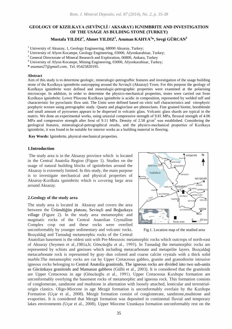
Rom. J. Mineral Deposits, vol. 87 (2014), No. 2, p. 35-38
35
GEOLOGY OF KIZILKAYA (SEVİNÇLİ / AKSARAY) IGNIMBRITE AND INVESTIGATION
OF THE USAGE AS BULDING STONE (TURKEY)
Mustafa YILDIZ1, Ahmet YILDIZ
2, Asuman KAHYA
3*, Sevgi GÜRCAN
4
1 University of Aksaray, 1, Geology Engineering, 68000 Aksaray, Turkey;
2 University of Afyon Kocatepe, Geology Engineering, 03000, Afyonkarahisar, Turkey;
3 General Directorate of Mineral Research and Exploration, 06800, Ankara, Turkey
4 University of Afyon Kocatepe, Mining Engineering, 03000, Afyonkarahisar, Turkey;
* [email protected], Tel. 05425820195.
Abstract
Aim of this study is to determine geologic, mineralogic-petrografhic features and investigation of the usage building
stone of the Kızılkaya ignimbrite outcropping around the Sevinçli (Aksaray) Town. For this purpose the geology of
Kızılkaya ignimbrite were defined and mineralogic-petrographic properties were examined at the polarising
microscope. In addition, in order to determine the physico-mechanical properties, testes were carried out from
Kızılkaya ignimbrite. Lower Pliocene Kızılkaya ignimbrite is acidic in composition, represented by welded tuff and
characteristic for pyroclastic flow unit. The Units were defined based on vitric tuff characteristics and vitrophyric
porphyric texture using petrographic study. Quartz and plagioclase are phenoclasts. Fine grained biotite, hornblende
and small amount of pyroxenes appears to be dispersed in volcanic glass. Volcanic glass shards are typical in the
matrix. We done an experimental works, using uniaxial compressive strength of 9.81 MPa, flexural strength of 4.06
MPa and compressive strength after frost of 9.11 MPa. Density of 2.58 g/cm3 was established. Considering the
geological features, mineralogical-petrographical results, and the physico-mechanical properties of Kızılkaya
ignimbrite, it was found to be suitable for interior works as a building material in flooring.
Key Words: Ignimbrite, physical-mechanical properties.
1.Introduction
The study area is in the Aksaray province which is located
in the Central Anatolia Region (Figure 1). Studies on the
usage of natural building blocks of ignimbrites around the
Aksaray is extremely limited. In this study, the main purpose
is to investigate mechanical and physical properties of
Aksaray-Kızılkata ignimbrite which is covering large area
around Aksaray.
2.Geology of the study area
The study area is located in Aksaray and covers the area
between the Ürümdüğün plateau, Sevinçli and Boğazkaya
village (Figure 2). In the study area metamorphic and
magmatic rocks of the Central Anatolian Crystalline
Complex crop out and these rocks were overlied
unconformably by younger sedimentary and volcanic rocks.
Bozçaldağ and Tamadağ metamorphic rocks of the Central
Anatolian basement is the oldest unit with Pre-Mesozoic metamorphic rocks which outcrops of north-east
of Aksaray (Seymen et al.,1981a,b; Göncüoğlu et al., 1993). In Tamadağ the metamorphic rocks are
represented by schists and gneisses which including metacarbonate and metapelite layers. Bozçaldağ
metacarbonate rock is represented by gray–dun colored and coarse calcite crystals with a thick solid
marble.The metamorphic rocks are cut by Upper Cretaceous gabbro, granite and granodiorite intrusive
igneous rocks belonging to Central Anatolia granitoids. The igneous rocks are divided into two sub-units
as Gücünkaya granitoids and Mamasun gabbros (Güllü et al., 2003). It is considered that the granitoids
are Upper Cretaceous in age (Göncüoğlu et al., 1991). Upper Cretaceous Kızıltepe formation are
unconformably overlying the basement rocks of metamorphic and igneous rock. This formation consists
of conglomerate, sandstone and mudstone in alternation with loosely attached, lenticular and terrestrial-
origin clastics. Oligo-Miocene in age Mezgit formation is unconformably overlain by the Kızıltepe
Formation (Uçar et al., 2008). Mezgit formation consist of conglomerate, sandstone,mudstone and
evaporites. It is considered that Mezgit formation was deposited in continental fluvial and temporary
lakes environments (Uçar et al., 2008). Upper Miocene Uzunkaya formation unconformably rest on the
Fig.1. Location map of the studied area

36
Mezgit Formation as well as Kızılkaya ignimbrites that cover it unconformably. Bottom level begins with
large size block material and towards the top continues as an alternation of coarse grained pebble and
fine-grained sandstone which reflects high and low energy periods. The Kızılkaya Ignimbrites has been
named by Beekman (1966) for the first time. It consist of white, off-white, light pink or gray in color and
exhibits a columnar structure due to the cooling cracks developing in the vertical direction (Figure 3). The
Kızılkaya ignimbrite is a product of acidic composition and show characteristic pyroclastic flow and
welded tuff. Kızılkaya ignimbrite range in age between 4.9 to- 5.5 ± 0.2 Ma according to K/Ar dating
and correspond to Lower Pliocene (Batum, 1981). In the study area Quaternary alluvial sediments are also
exposed in Ürümdüğün plateau and Keçeli area and consist of volcanic-origin of fine grained silt and
clay materials. Actual Quaternary alluvial deposits consist of unconsolidated sand and gravel material.
This unit outcrop in the Aksaray plain, Hamamboğazı creek and in the Uluırmak.
Fig. 2. Geologic map of the vicinity of Akasaray (Yıldız at al., 2002).
Fig. 3. General view of the Kızılkaya İgnimbrite
a b
c d
LEGEND

37
3. Material and Methods
Investigation material is ignimbrite from Sevinçli (Aksaray) area. Petrographic observations (optical
microscopy) in thin sections of fresh samples were used to establish textural properties and to identify
mineral species with Leica DM 2500 P polarizing in Aksaray University Geology Engineering
Laboratuary. Physical and mechanical tests on ignimbrite sample were performed in Afyon Kocatepe
University, Department of Mining Engineering Laboratory. Data on the physical and mechanical
properties obtained in experiment are given in Table 1. Interpretation of experiments given in Table 1
with related standards, besides these standarts TS 10449 standards and TS 6234 have also been used.
4. Physical and Mechanical Properties of İgnimbrite
TS 2513 states that specific gravity could not be lower than 2.55 g/cm3 for natural building stones.
Specific gravity of Sevinçli region ignimbrites is 2.58 g/cm3 and this value is close to standart as shown in
Table 1. TS 2513 indicate that apparent density of natural building blocks should be of 2300 kg/m3 (2.30
g/cm3), The apparent density of natural stone which used cover stone require up to 2550 kg/m
3 (2.55
g/cm3) according to TS 1910. Apparent density of Sevinçli ignimbirites is 1,45 gr/cm
3 which is under the
accepted value (Table 1). Maximum porosity value of natural stone to be used for cover stone is 2%
according to TS 1910. Porosity value of study area ignimbrite is 25.5%, this value is very high according
to the standard value. On the other hand 25.5% porosity value of ignimbrites in the study area offer
possibility of evaluating the thermal insulation properties, since for thermal insulation, larger part of the
rock pores should be closed pores. According this the study area ignimbrite has an ideal thermal
insulation chareacteristic for buildings. Water absorbtion by mass should be lower then 0,75% according
to TS 2513. The high water absorbtion value of Sevinçli ignimbrite indicates the high porosity of the
rock. This porous structure of the rock is a disavantage. Compressive strength of Sevinçli area ignimbrite
has 9.81 MPa, as given in the Table 1. Uniaxial compressive strength of Sevinçli area ignimbrite show
‘very low strength ' value according to to Deere and Miller (1966) , also it is lower then value for
metamporphic rocks (50 Mpa) given in TSE 2513. It can be concluded that high porosity of the rock
decrease the uniaxial compressive strength to 9. 11 MPa after freezing. Bending strength value of
ignimbrite is 4.06 MPa. Bending strength value of natural building stone should be 50 kgf/cm2 (5 MPa) in
TS 2513. Accordingly, bending strength value of Sevinçli ignimbrite is lower then given by TS. Ultra
sound velocity of the Sevinçli ignimbrite has 2443 m/s, and the results are given in Table 1. The main
reason is due to the high porosity. By increase the porous structure within the stone, the sound wave
propagation and speed decreases. Schmidt hardness of the Sevinçli ignimbrite was obtained as 29.56
(Table 1). According to Schmidt hardness classification value the Sevinçli ignimbrite is a ‘less rigid’ rock
(Brown, 1981).
Table 1. Standards used and results of the physical and mechanical properties of studied ignimbrite.
Test Name Standart No Result
Specific gravity (gr/cm3) TS EN 1936 2.58±0.02
Apparent density (gr/cm3) TS EN 1936 1.45±0.17
Water absorbtion (%) TS EN 13755 17.86±2.45
Open porosity (%) TS EN 1936 25.5±0.86
Compressive Strength (MPa) TS EN 1926 9.81±1.67
Ulrasound (m/sn) TS EN 14579 2443±476.31
Schmidt Hardness ISRM 29.56±3.94
Bending Strenght (MPa) TS EN 13161 4.06±0.48
Compressive Strength after freezing cycle (MPa) TS EN 12371 9.11±1.98
5. Conclusion Mechanical properties of studied ignimbrites were compared with TS 10449, TS 1910, TS 2513 and TS
6234. The results are listed below:
- Specific gravity of ignimbrites is suitable for interior and exterior works in flooring according to the TS
2513.

38
- Sevinçli ignimbrites does not provide the necessary requirements given in TS 10449, TS 1910, TS
2513, TS 6234 on compresive strength, compresive strength after frezing, bending strength, Schmidt
hardness, porosity and weter absorbtion. Therefore, Sevinçli (Aksaray) Kızılkaya region ignimbrites
showing low strength in terms of physico-mechanical properties can be identified as more suitable for use
in the interior works floors. In addition, because the high porosity value (25.5%) the ignimbrite in this
region should be investigated in detail to determine their characteristics for the thermal conductivity.
6.References
Beekman, P.H., 1966.The Pliocene and Quaternary volcananism in the Hasandağ-Melendizdağ region:
Bulletin MTA, 66, 90-105.
Batum, İ., 1981. Petrografhische und Geochemisce Undersunchungenin den Vulkangeibeten Göllüdağ
and Acıgöl (Zentraloratolie, Turkei) Doktora Tezi, Albert-Luawinas Üniv. Friburg, Almanya,
102s, 1975.
Brown, E. T., “Suggested Methods of Rock Characterization Testing and Monitoring”, International
Society for Rock Mechanics, Portugal, s. 53.
Deere, D.U. and Miller, R., 1966. “Engineering Classification and Index Prosperities for Intact Rock”,
Technical Report No: AFNL-TR-65-116 Air Force Weapons Laboratory, New Mexico, USA.
Göncüoğlu, M.C., Erler, A., Toprak, V., Olgun, E., Yalınız, K., Kuşçu, İ., Köksal, S., Dirik, K., 1993.
Geology of Central Department of Anatolian Massif Central, Section-3, Medium Red River Basin
Tertiary Geological Evolution of: TPAO Report No: 3313, 104s.
Göncüoğlu, M.C., Toprak, V., Kuşçu, İ., Erler, A., Olgun, E., 1991. Orta Anadolu Masifinin Batı
Bölümünün Jeolojisi, Bölüm-1, Güney Kesim: TPAO Rapor no:2909, 140s. Yayınlanmamış.
Güllü, B., 2003. Geologic, petrographic and geochemical investigations of Mamasun Region (Aksaray)
igneous rocks, M.Sc. Thesis, Nigde University, 163.
Seymen, İ.,1981 a. Stratigraphy and metamorphism of Kaman (Kırşehir) in the Kirsehir Massif .TJK
Bulletin, 24/2, 101-108.
Seymen, İ., 1981 b. Metamorphism of the Kaman (Kirsehir) in the Kirşehir massif, Turkey Jeol. Bull. 35
Scientific and Technical Conference 'Symposium on the Geology of Central Anatolia, 12-15.
Uçar, L., 2008. Stratigraphic study of the area Hanobası-Karapınar (NW Aksaray), Geosound :52, 185-
212.
Yıldız, M., Yeken, T., Onak, A., 2002. Geology of Aksaray, geological and geotechnical assessment of of
soil properties in the Bahçelikent Mass Housing Area of Aksaray Municipality, Aksaray, 41.
Standards:
TS EN 1936. 2001. Natural Stones - Test methods - Real Density, Apparent Density, Determination of
total and open porosity. Turkish Standards Institute.
TS EN 13755, 2003. Natural Stones - Test methods - Determination of Water Absorption at Atmospheric
Pressure. Turkish Standards Institute.
TS EN 1926. 2000. Natural Stones - Test methods - Determination of Compressive Strength. Turkish
Standards Institute.
TS EN 14579. 2006. Natural Stones - Test methods - Determination of Sound Speed Progress. Turkish
Standards Institute.
TS EN 13161. 2003. Natural Stones - Sticky Moment-Deflection Test Method for Determination of
Strength. Turkish Standards Institute
TS EN 12371, 2003. Natural Stones-Test methods-Determination of frost resistance of the Turkish
Standards Institute
T.S.E., 2004. “Mermer Marble-Based Structure of Calcium Carbonate and Coatings Used As Amended
Move”, TS 10449/T1, Ankara.
T.S.E., 2004. ‘Granite-Building and Amendment 1 is used as the coating Move’, TS 6234, Ankara,
T.S.E., 1977. ‘Natural Building Blocks', TS 2513 ICS 91.100.15, Ankara.
T.S.E., 1977 “Used as covering of Natural Stone”, TS 1910 UDK 691.215, Ankara.

Rom. J. Mineral Deposits, vol. 87 (2014), No. 2, p. 39-42
39
SELECTED ELEMENT DISTRIBUTION IN BOTTOM SEDIMENT SAMPLES FROM TRÊS
MARIAS LAKE AND ITS SIGNIFICANCE, MINAS GERAIS, BRAZIL
Adolf Heinrich HORN1*
, Hernando BAGGIO2, Rafaelle SCHIMITH
3
1 – NGqA-DeGel-IGC-UFMG, Av. Antônio Carlos, 156 Belo Horizonte-MG; *[email protected]
2 – LGA - UFVJM – Diamantina-MG
3 – Independent Researcher
Abstract. The Três Marias Lake is an important water reservoir at the upper to middle São Francisco River. It is
important for irrigation, drinking water supply, fish raising and tourism. Therefore the water contamination is a very
serious problem. The paper presents the connection between land uses/industry and water-/ sediment composition in
space and evolution in time.
It is to observe that industry is not more the principal contributor and is replaced by intensive agriculture activity in
the surroundings.
Key words: Water contamination, sediment contamination, agriculture, industry, environmental impact
Introduction
South of the city of Três Marias a storage lake was installed and finished on 01.03.1963 to push the
industrial and agricultural evolution in the São Francisco valley and to avoid future overflooding. The
lake is situated in the municipal district of Andrequicè and touches the districts of Lassance, Buritizeiro,
São Gonçalo do Abaeté, Morada Nova de Minas, Felixlândia, Corinto, affecting their hydrological
situation and climate. The drainagearea of the lake is about 50,600 km2 and its surface is of about 1,090
km2 with a volume of 19,528 hm³.
The investigated area is situated in the central-western part of Minas Gerais State, about 270 km away
from Belo Horizonte, south of the city of Três Marias. The access is by BR-040 in direction of Brasília
(Figure 1).
The climate of the region is subtropical to tropical with clear defined rainy and dry periods (Ab´Saber,
1971). The vegetation is a transition between Cerrado (Savannah), Dry Forrest and Caatinga (IEF, 2005).
The lake shows distinct periods with high and low water levels (DNPM/MME, 1989), controlled by
natural input, evaporation and dam regulation of the output. From the 80s the effective water reserve
reduced to less than 40% in 2013.
Figure 1. Localization map of the Três Marias Lake with the different sampling areas due to present contamination
sources like river contribution, land use or other human influenced factors. (CPRM, 2003; modified).
1: North-western Valley – Family agriculture; 2: Eastern Margin – Traffic influence; 3: Morada Nova
Region – Settling, fish raising; 4: Extrema River – Forrest economy; 5: Paropeba River – Heavy
Industry, settling, forest economy; 6: São Francisco Valley – Extensive agriculture, forest economy.

40
The system of the lake including the drained area is intensively used by agriculture activities like cattle
raising, seed production, forest exploitation for wood, charcoal and cellulose, extensive corn and cotton
production and fish raising.
Almost the whole shores of the lake are influenced by extensive tourism, bathing, intensive fishing and
boat traffic.
The nearby zones of the lake are influenced by heavy industry, agriculture, digging activities, sewage
water and other contaminating sources (Figure 1).
The changes in land use around the Três Marias Lake are shown in Figure 2 (space images taken from
different years).
Figure 2. Space images showing the evolution of land use from 1990 up to 2010.
Left: Principally natural vegetation like savannah, dry forests and outcrops of sediments. Middle:
Beginning of agriculture activities and forests; Right: Intensive forests) and agriculture activities.
Activities
The method of field sampling and sample treatment was based on the guide by CETESB (CETESB,
1988).
Field work
The sampling of sediments has been done by Schimith from 2011 to 2012 (Figure 1; eight campaigns)
during six month and compared with data from Schilling (1991; one campaign) collected in 1990 and
Oliveira (2007).
The localization has been done by triangulation (first campaign; 1990) and by GPS-localization (last
campaigns; 2012). At the sampling points other physical-chemical parameters like temperature, pH,
conductivity, eH, color, turbidity and DOB of the water were determined.
Transport
The samples, water (1l), sediments (1-2kg), were transported to the laboratories in Belo Horizonte,
sediment samples in plastic bags and bottles in cooling boxes. Then the samples were stored in freezers.
Laboratory stage
Preparation of the sediment samples
The samples were dried, sieved and the fine fraction was analyzed.
The extraction was done by water (pH of rainwater), weak acid (10% HNO3) and concentrated acid (conc.
HNO3).
Analytics
For analyzing the selected elements the equipment of XRF (ACME-Lab) and ICP-OES (NGqA-IGC) was
used with national and international standards.
Results
The analytical results from sediment sample show that soluble metal concentration changes significantly
from 1990 to 2012. The changes in concentration show the influence of increasing of environmental
protection activities and the changes in intensity, quality and output of the principal sources (Table 1)
together with the reduction of free metal ions in water samples and increase of clay- and oxide bounded
ions.
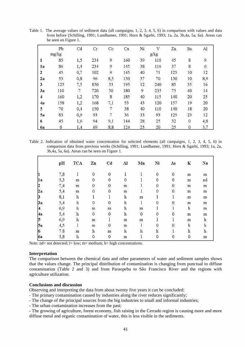
41
Table 1. The average values of sediment data (all campaigns, 1, 2, 3, 4, 5, 6) in comparison with values and data
from before (Schilling, 1991; Lundhamer, 1991; Horn & Sgarbi, 1993; 1a, 2a, 3b,4a, 5a, 6a). Areas can
be seen on Figure 1.
Table 2. Indication of obtained water concentration for selected elements (all campaigns, 1, 2, 3, 4, 5, 6) in
comparison data from previous works (Schilling, 1991; Lundhamer, 1991; Horn & Sgarbi, 1993; 1a, 2a,
3b,4a, 5a, 6a). Areas can be seen on Figure 1.
Note: nd= not detected; l= low; m= medium; h= high concentrations.
Interpretation
The comparison between the chemical data and other parameters of water and sediment samples shows
that the values change. The principal distribution of contamination is changing from punctual to diffuse
contamination (Table 2 and 3) and from Paraopeba to São Francisco River and the regions with
agriculture utilization.
Conclusions and discussion
Observing and interpreting the data from about twenty five years it can be concluded:
- The primary contamination caused by industries along the river reduces significantly;
- The change of the principal sources from the big industries to small and informal industries;
- The urban contamination increases from the past;
- The growing of agriculture, forest economy, fish raising in the Cerrado region is causing more and more
diffuse metal and organic contamination of water, this is less visible in the sediments.

42
Sediment samples show the longtime contamination, indicating a reduction of the industrial participation
from 1990 till 2010 in contaminant liberation.
The parallel taken water samples supported these considerations and indicate a stronger contribution of
small industries, urban centers and agriculture activities (s.l.). The problem is the diffuse contamination
caused by these activities reaching more parts of the river and complication processes of auto healing.
The temperature, conductivity, pH and turbidity distribution show the recuperation and force of the lake
to recover or mitigate problems from the contributors to the dam.
Acknowledgement
The authors thank the UFMG, UNIMONTES, Votorantim for logistical and CNPq and FAPEMIG for
financial support. The Association of fishermen helped us with their knowledge about the lake.
References
Ab Saber, A.N., 1971. A organização natural das paisagens inter e subtropicais brasileiras In: Simpósio
do Cerrado. São Paulo: Brasil.
CETEC, 1980. Estudos de metais Pesados no Estado de Minas Gerais. Relatório final. Sistema
Operacional de Ciências e Tecnologia. Belo Horizonte.
CETESB, 1988. Guia de Coleta e Preservação de amostras de água. 1 ed. São Paulo. 149p.
CETESB. 2001. Relatório de Estabelecimento de Valores Orientadores para Solos e Águas Subterrâneas
no Estado de São Paulo. São Paulo. 73 p.
CPRM - Companhia de pesquisa e recursos minerais. Serviço Geológico do Brasil. 2003. Projeto São
Francisco: 455p.
DNPM/MME, 1989. Boletim Fluviométrico F4.01. Brasília.
Horn, H.A., Sgarbi, G.N.C. 1993. Investigações sobre a contaminação dos sedimentos e da água do rio
São Francisco e seus afluentes no Estado de Minas Gerais. 4 ENESMA, Cuiabá: 5p.
IEF- INSTITUTO ESTADUAL DE FLORESTA 2005. Mapeamento da Cobertura Vegetal e Uso do Solo
do Estado de Minas Gerais. 248p
Lundhamer, S. 1991. Erfassung der Kontamination an Metallen im Flusswasser des São Francisco bei
Três Marias, Brasilien. Diplomarbeit, Fachhochschule München: 74p.
Oliveira, M.R. de, 2007. Investigações da contaminação por metais pesados da água e do sedimento de
corrente nas margens do Rio São Francisco e Tributários, a jusante da represa da CEMIG, no
município de Três Marias, Minas Gerais. PHd -Teses. UFMG: 172p.
Schilling, R., 1991. Schwer-und Leichtmetallanalysen eines brasilianischen Gewässers. Diplomarbeit,
Fachhochschule München: 66p.

Rom. J. Mineral Deposits, vol. 87 (2014), No. 2, p. 43-46
43
HEAVY METALS AND ALUMINUM CONTENT INSIDE SILICOPHYTOLITHS FROM
RICINUS COMMUNIS, ANDROPOGON ARUNDINACEUS AND BRACHIARIA
DECUMBENS GROWN ON SOILS ADDED WITH SEWAGE SLUDGE
AND HEAVY METAL SALTS (BRAZIL)
Adolf Heinrich HORN
1*, Igo Fernando LEPSCH
2**, Regynaldo Arruda SAMPAIO
2,
Márcio Neves RODRIGUES2, Anarelly Costa ALVARENGA
2, Ely Sandra Alves de OLIVEIRA
2
1 - Instituto de Geociências, Universidade Federal de Minas Gerais, Belo Horizonte, MG, Brazil;
*[email protected] 2 - Instituto de Ciências Agrárias, Universidade Federal de Minas Gerais, Montes Claros, MG, Brazil;
**[email protected] Abstract: Silicophytoliths are opal corpuscles formed by some plants. These particles can trap small amounts of
elements like Al and some undesirable heavy metals. In this paper elemental analysis of silicophytoliths of three
species grown on soils added with sewage sludge and heavy metal salts were performed in order to verify
amounts of heavy metals and Al they can trap. The results show that all studied plants can trap small amounts
of heavy metals in their opal structure and that the plants that produce high amounts of silicophytoliths can
clean soils fertilized with sewage sludge used in agriculture. Key words: Phytoliths, sewage sludge, contaminated soils, phytoextraction, phytoremediation. 1. Introduction Phytoextraction (phythoremediation) has been suggested as a viable alternative to traditional restoration
practices for heavy metal-contaminated soils in view of the lower costs and lower environmental impact
(e.g. soil fertilized with sewage sludge and land fill areas of mines). The heavy metals and aluminum that
plants extract are toxic, and the plants used for phytoextraction are known as hyper accumulators that
have the ability to sequester large amounts of toxic metals both in their organic and mineralized parts
(Oliva et al., 2011).
Mineralized tissues are common in animals and plants. In almost every phylum outside the animal
kingdom taxa can be found in which biomineralizaton also occurs. Silicon is omnipresent in soils in the
form of minerals and others, thus it is an element ubiquitous in the plant environment. Due to soil
conditions silicon dioxide and aluminum silicates are normally only slightly soluble forming free silicic
acid. The variations of Si-contents are low within a plant species. The Poaceae, generally have high
silicon contents (>4% dry weight) while many other plant families are poor in silicon (Bauer et al.,
2011).
Plants during their vegetative cycle absorb most of the Si as silicic acid [Si(OH)4] which, during
transpiration and under polymerization process, is synthesized to opal silica (so called “plant-opal”,
SiO2∙nH2O). They form small (50-2 µm) opal corpuscles known as silicophytoliths which may also
contain significant concentrations of other elements (Wilding & Drees, 1971). Silicophytoliths, besides Si
and O, contain small amounts of Al, Fe, Mn, Mg, P, Cu, N and inorganic C ranging from 1% to 5% of
total phytolith weight (Bartoli & Wilding, 1980). These elements are present in the cytoplasm of living
cells and then retained when cells become impregnated with solid silica, becoming enclosed within the
silicophytolith (Wilding et al., 1977). These particles have important beneficial physiological functions
like the immobilization of plant toxic ions such as aluminum and heavy metals (Buján, 2013).
After senescence and decomposition of plant debris, the silicophytoliths are dispersed in the soil where
they remain as one of their stable major components. Since the silicophytoliths have the ability to
sequester heavy metals, and because they remain unchanged by weathering in the soil for many years,
they can be used to recover contaminated soil with these elements through processes of
phytoremediation.
The objective of this work is to find out which elements and in which quantity the selected plants can
trap in their silicophytoliths. The plants were grown in soil with and without addition of sewage sludge
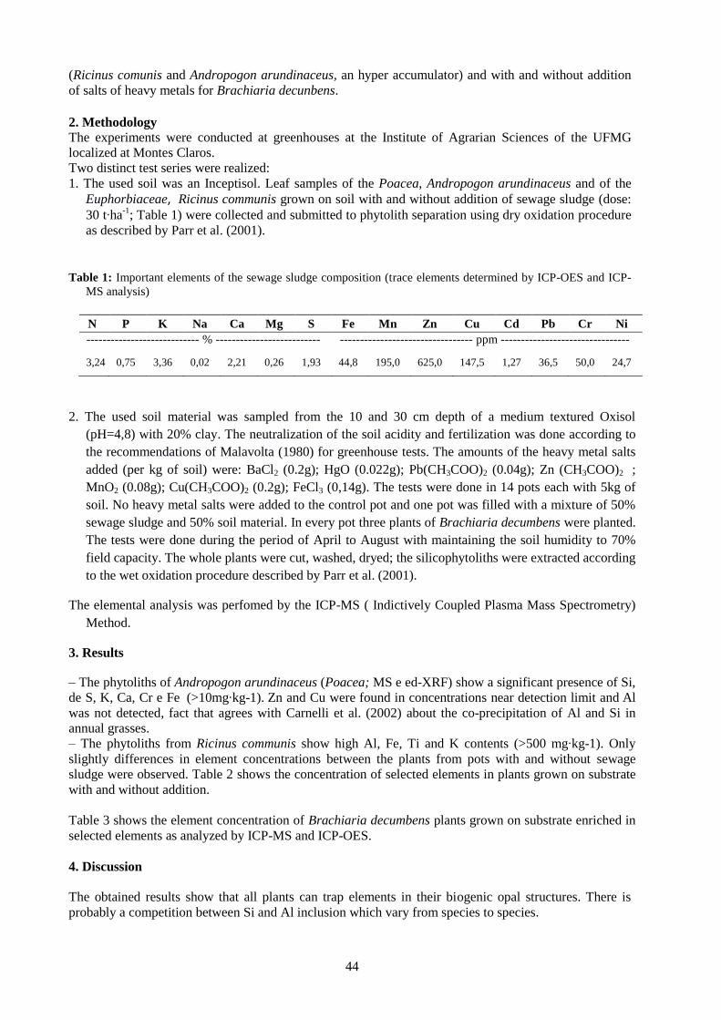
44
(Ricinus comunis and Andropogon arundinaceus, an hyper accumulator) and with and without addition
of salts of heavy metals for Brachiaria decunbens. 2. Methodology The experiments were conducted at greenhouses at the Institute of Agrarian Sciences of the UFMG
localized at Montes Claros. Two distinct test series were realized: 1. The used soil was an Inceptisol. Leaf samples of the Poacea, Andropogon arundinaceus and of the
Euphorbiaceae, Ricinus communis grown on soil with and without addition of sewage sludge (dose:
30 t∙ha-1
; Table 1) were collected and submitted to phytolith separation using dry oxidation procedure
as described by Parr et al. (2001). Table 1: Important elements of the sewage sludge composition (trace elements determined by ICP-OES and ICP-
MS analysis)
N P K Na Ca Mg S Fe Mn Zn Cu Cd Pb Cr Ni
---------------------------- % --------------------------
---
--------------------------------- ppm --------------------------------
- 3,24 0,75 3,36 0,02 2,21 0,26 1,93 44,8 195,0 625,0 147,5 1,27 36,5 50,0 24,7
2. The used soil material was sampled from the 10 and 30 cm depth of a medium textured Oxisol
(pH=4,8) with 20% clay. The neutralization of the soil acidity and fertilization was done according to
the recommendations of Malavolta (1980) for greenhouse tests. The amounts of the heavy metal salts
added (per kg of soil) were: BaCl2 (0.2g); HgO (0.022g); Pb(CH3COO)2 (0.04g); Zn (CH3COO)2 ;
MnO2 (0.08g); Cu(CH3COO)2 (0.2g); FeCl3 (0,14g). The tests were done in 14 pots each with 5kg of
soil. No heavy metal salts were added to the control pot and one pot was filled with a mixture of 50%
sewage sludge and 50% soil material. In every pot three plants of Brachiaria decumbens were planted.
The tests were done during the period of April to August with maintaining the soil humidity to 70%
field capacity. The whole plants were cut, washed, dryed; the silicophytoliths were extracted according
to the wet oxidation procedure described by Parr et al. (2001).
The elemental analysis was perfomed by the ICP-MS ( Indictively Coupled Plasma Mass Spectrometry)
Method.
3. Results
– The phytoliths of Andropogon arundinaceus (Poacea; MS e ed-XRF) show a significant presence of Si,
de S, K, Ca, Cr e Fe (>10mg∙kg-1). Zn and Cu were found in concentrations near detection limit and Al
was not detected, fact that agrees with Carnelli et al. (2002) about the co-precipitation of Al and Si in
annual grasses.
– The phytoliths from Ricinus communis show high Al, Fe, Ti and K contents (>500 mg∙kg-1). Only
slightly differences in element concentrations between the plants from pots with and without sewage
sludge were observed. Table 2 shows the concentration of selected elements in plants grown on substrate
with and without addition.
Table 3 shows the element concentration of Brachiaria decumbens plants grown on substrate enriched in
selected elements as analyzed by ICP-MS and ICP-OES.
4. Discussion
The obtained results show that all plants can trap elements in their biogenic opal structures. There is
probably a competition between Si and Al inclusion which vary from species to species.
Rom. J. Mineral Deposits, vol. 87 (2014), No. 2, p. 43-46
45
In substrates containing sewage sludge, there is lower concentration of heavy metals in the plant
phytoliths, possibly due to strong bonds with organic matter and hence low element absorption. Another
possibility is for heavy elements concentration in roots silicophytoliths, not analysed yet.
Table 2: Concentration of elements in phytoliths from Andropogun arundinaceus grown on substrate with or
without sewage sludge addition. The analyses were done with ICP-MS equipment. The results show
significant enrichment of some interest trace elements in the leaves.
Factor Fe Mn P K Ca Mg Al Ti Mo Cd Cu Ni
------------------------------------------ % ------------------------------------- ----------------- ppm ----------------
Without
sludge 0,03 11,00 0,04 0,08 0,08 0,04 0,08 <0,01 17,56 0,05 28,91 3,10
With
sludge 0,03 8 0,08 0,04 0,02 0,01 0,19 0,04 8,3 0,41 118,8 2,9
Factor Pb Zn Cr Ba B Sc Ga Hg Ag Re Pt
------------------------------- ppm ---------------------------------- ---------------------- ppb ----------------------
Without
sludge 499,1 11,6 1,9 12,0 <20 0,2 0,1 0,1 105 <1 <2
With
sludge 88,24 2,5 4,9 16,5 80 0,5 2,0 0,3 418 2 <2
Table 3: Element concentration in phytoliths of Brachiaria grown on contaminated substrates. The analyses were
done by ICP-MS. For comparison some data from geological opal formed in volcanic environment with
high element concentrations in the solutions (Marinoni et al., 2012).
Factor Fe (%) Mn (ppm) Cu (ppm) Zn (ppm) Ba (ppm) Hg (ppb)
Soil with Fe 0,05 9 35 11,33 13 0,1
Soil with Mn 0,04 12 33 12,1 14 0,1
Soil with Zn 0,03 8 29 2,9 12 0,2
Soil with Cu 0,02 10 453,2 12,5 12 0,1
Soil with Ba 0,03 10 28 11,8 25,8 0,2
Soil with Hg 0,03 10 28 11,3 11 0,5
Soil/Sewage sludge 0,03 8 118,8 2,5 16,5 0,3
Pure soil 0,03 11 28,91 11,6 12 0,1
Volcanic opal 0,02-0,05 42-45 3-15 2-6 4-5 -
However, for Ba and Cu there is a significant increase in their concentration when the Brachiaria plants
grown on soil that contains high concentration of these elements; this is in agreement with results
obtained by Oliva et al. (2011). In soils that received sewage sludge (source of Cu) it was noted a great
increase of concentration in this element in the silicophytoliths. This fact shows the phytoliths importance
in sewage sludge phytoremediation for agricultural use.
The processes of incorporation and the regulating factor are still not very clear and need more studies.
Still the fact that plants retain considerable amounts of elements in their silicophytolites and that this
particles liberate slowly the trapped elements than the biological part of plants can be used in
decontamination processes and impact mitigation. But how the plants retain elements in their
silicophytolites and they are less soluble than plant parts they can be used in decontamination processes
and/or impact mitigation.
46
The results of this investigation may help to plan phytoremediation actions in order to decontaminate
areas by the selection of plants that are able to incorporate heavy metal contaminants inside their
silicophytoliths.
5. Acknowledgement:
The authors thank the UFMG, CNPq and FAPEMIG for logistical and financial support 6. References
Bartoli F., Wilding L.P., 1980. Dissolution of biogenic opal as a function of its physical and chemical
properties. Soil Sci. Soc. Am. Journal, Vol. 44, 4, p. 873-878.
Bauer P., Elbaum R., Weiss I.M., 2011. Calcium and silicon mineralization in land plants: Transport,
structure and function. Plant Science, 180, p. 746–756.
Buján E., 2012. Elemental composition of phytoliths in modern plants (Ericaceae). Quaternary
International, 287, p. 114-120.
Carnelli A.L., Madella M., Theurillat J.P., Ammann B., 2002. Aluminum in the opal silica reticule of
phytoliths: A new tool in palaeoecological studies. Am. J. Bot., 89, p. 346-351.
Marinoni L., Bordoni V., Ghisoli C., Adamo I., 2012. Physical and chemical properties of some Italian
opals. Periodico di Mineralogia, 81, 1, p. 93-106
Malavolta E., 1980. Elementos de nutrição mineral de plantas. São Paulo, Agronômica Ceres. 253p.
Oliva S. R., Mingnorance M.D., Leidi E. O., 2011. Effects of silicon on copper toxicity in Erica
andevalencis Cabezudo and Rivera: a potecial species to remediate contaminated soils. J.
Environ, Monit., 13, p. 591-596
Parr J.F, Lentfer C.J., Boyd W. E., 2001. A comparative analysis of wet and dry ashing techniques for
the extraction of phytoliths from plant material. J. Arch. Sci, 28, p. 875-886.
Wilding L.P., Smeck N.E., Drees L.R., 1977. Silica in soils: quartz, cristobalite, tridymite and opal. In:
Dixon J.B., Weed S.B., (Eds.): Mineral in Soil Environments. Madison, Soil Science Society of
America, p 471-542.
Wilding L.P., Drees L.R., 1971. Biogenic opal in Ohio soils. Soil Science Society of America
Proceedings 35, p 1004-1010.

Rom. J. Mineral Deposits, vol. 87 (2014), No. 2, p. 47-50
47
RAINFALLS AND NATURAL DISASTERS: THE 2011 - 2012 EVENTS IN MINAS GERAIS
STATE - BRAZIL
Hernando BAGGIO1*, Heinrich
HORN
2, Thiago MARTINS
3, Matheus SIMÕES
3
1 University of Diamantina – UFVJM – Minas Gerais/Brazil
2 University of Federal de Minas Gerais-UFMG-Minas Gerais/Brazil
3 Faculty of Geography, UFVJM – scholarship/FAPEMIG-Minas Gerais/Brazil
* [email protected]; Tel.: 0055 38 37411157; Fax.: 0055 38 37411157
Abstract: This brief communication was compiled from recent data on the latest events of natural disasters
2011/2012 in Minas Gerais State. In Brazil, the risk associated with accidents and geological processes are purely
exogenous, with landslides and related processes which cause much loss of life. These natural phenomena are often
conditioned by atmospheric general circulation systems operating in the region of Brazil, especially during summer,
and use geological and other variables in the following order: geomorphological, topographical, pedological,
hydrological and land use. The summer of 2011/2012 began catastrophically; it was characterized by one of Brazil's
worst ever natural disaster, the scene of the tragedy was the Minas Gerais state, namely several municipalities in
Minas Gerais. Accodding to the State Civil Defense, the tragedy implied 2,495 people, the number of homeless rose
to 25,514 and 15 people have died and 3 were missing.
Keywords: Minas Gerais, rainfall, natural disasters, tragedy
Introduction
Natural disasters are a theme more and more present in everyday’s people lives, independently whether
they live or not in areas of risk. Although at first sight the term leads us to associate it with earthquakes,
tsunamis, volcanic eruptions, cyclones and hurricanes, Natural Disasters also include processes and more
localized phenomena such as landslides, flooding, subsidence and erosion, which may occur naturally or
induced by man. Brazil is among the most affected countries by floods and disasters of the world, having
recorded 94 registers in the period from 1960 to 2008, with 5,720 deaths and more than 15 million people
affected (homeless/displaced); the most natural disasters are associated with severe weather events that
are responsible for triggering floods, windstorms, hail and landslides. Over 60% of these events occur in
the south-southeast part; in those regions atmospheric instability is common due to cold fronts in the
winter, occurrences of mesoscale convective complexes in the spring (MCC) and the formation of
convective systems in the summer, especially The South Atlantic Convergence Zone, or SACZ, these
systems achieve a wide range of central Brazil (Instituto Geológico, 2009). The summer of 2011/2012
began catastrophically, it was characterized by one of Brazil's worst ever natural disaster, the scene of the
tragedy was Minas Gerais State, where several municipalities - 62% - were affected by disasters related to
severe rainfall events. In the first seven days of January 2012, it rained in Belo Horizonte corresponding
to 22% above the expected average for all the month, 334 mm of rain, causing flooding in various parts of
urban areas, floods and gravitational mass movements - landslides. The total number of homeless and
displaced people in Minas Gerais due to floods that hit several cities doubled after the update data made
by the State Civil Defense – CEDEC/MG, and exceeds 2,495 people, the number of homeless rose to
25,514 and 15 people have died and 3 were missing (CEDEC-MG, 2011).
Location and physiographic features
Minas Gerais is one of 27 states of Brazil, located in southeastern part being the fourth largest in area –
586,528 km² - the state is the second most populated in Brazil, with almost 20 million habitants. The state
capital is Belo Horizonte, with about 5,5 millions habitants, and thus, the third largest urban
agglomeration in the country. The state of Minas Gerais is located between parallels 14°13'58'' and
22°54'00'' South latitude and meridians 39°51'32'' and 51°02'35'' W-Gr. Altimetrically the altitude ranges
from 450 to 1,700 meters. The relief of Minas Gerais includes 5 relief units: Cristalline plateaus,
Espinhaço Range, San Franciscana depression, São Francisco Plateau, and Paraná Plateau, resulting from
an alternation of processes: morphoclimatic, morphostructural, morphosculptural and morphotectonic
(CETEC, 1983).
Reis (2001) defined the climate for Minas Gerais as follows: Aw - Tropical rain; Cwa - hot tempered;
Cwb - cold tempered. Average annual rainfall in Minas Gerais varies from 900mm to 1,800mm.
Temperatures vary from 23°C to 24°C. Rainfalls during the summer months are intensified, causing
floods and landslides in several municipalities of the state, due to the occurrence of the Convergence
Zone of the South Atlantic (SACZ). The SACZ is usually oriented northwest-southeastward and is

48
associated with a convergence zone in the lower troposphere, which extends from the south of the
Amazon to the Atlantic Center, a few thousand kilometers (Diaz, 1992). Originally the vegetal coverage
of Minas Gerais is made up of four major biomes: Cerrado, Atlantic forest, Dry forest and Rupestris fields
(CETEC, 1983).
Fig. 1. (a) Location map of Minas Gerais and (b) altimetric map. Source: CETEC-MG, (1983).
Methods
For this compilation of recent data on the latest events of natural disasters 2011/2012 in Minas Gerais
State, the work had a qualitative character. Some activities are considered of paramount importance in
planning the project methodology, among them: bibliographic and cartographic research, which consisted
in a comprehensive survey and review of surveys as well as studies in risk areas, environments and also
aspects of the physical, economical, social and environmental context of regional and local area surveyed.
All data were tabulated and maps have been generated using Corel Draw X3 software.
Results and discussion: Irregular occupation of risk areas without soil use planning, associated to
climate changes, have caused disasters in the world, with such intensity that forces us to reflect on the
occupation of the planet and the need of changing attitude. In the last rainy season, Brazilian media
showed several disasters. Among them, we highlight the floods and landslides that occurred in the
mountainous region of the State of Rio de Janeiro, where there were recorded 919 deaths, 4,563 injured
and 252,680 people affected. It shows that the result of the disaster magnitude presents significant
numbers of human damage, without considering the environmental, economic and social damage. In the
State of Minas Gerais, 25,32% of the cities were hit by rain-related disasters in the period 2010/2011and
2012, the south and the Zona da Mata together accounted for 40,05% of total disaster and were the most
affected (CEDEC-MG, 2011).
Evolution of rain-related disasters in the State of Minas Gerais
During the last rainy season (2010/2011), an increase of 0,47% in the number of municipalities affected
by disasters caused by heavy rains in Minas Gerais State has been noticed, compared to the historic
average of the last nine years, which was of 216 municipalities in this period (Fig. 2). Regarding the
number of processes homologated, there is an increase of 12,79% compared to the historical average of
86 cases (Table 1).
Figure 3 shows that in the period 2009/2010, the highest incidence of rain-related disasters occurred in
November and December, the largest volume of rainfall recorded. During this period (2010/2011), the
highest incidence was in January, which recorded 38.43% of the municipalities affected, followed by the
month of December with 24.07%. It was registered during the two months together 62.5% of total
disasters. Through the evaluation form of damage (Avadan) the human damage, environmental and
economic and social losses of the municipalities affected by rains were measured in the period
2010/2011. The losses were in the order of US$ 515,635.198. In comparison with the average of the three
previous periods (2007-2010) US$ 196,612.161, there was an increase of 162,26% in the total measured
by Avadan (CEDEC-MG, 2011).
A B

49
Table 1. Number of municipalities affected by the disasters caused by heavy rains in the State of Minas Gerais in the
period 2001 to 2011.
Disaster 2001/02 2002/03 2003/04 2004/05 2005/06 2006/07 2007/08 2008/09 2009/10 2010/11
Municipalities
affected
239 261 218 234 152 316 121 276 210 216
Processes
homologated
169 136 105 50 20 158 7 100 29 97
Fig. 2. Cities most affected by natural disasters (floods, flooding and landslides). Source: CEDEC-MG, (2011).
Fig. 3. Comparison of the monthly evolution of the number of municipalities affected by disasters caused by heavy
rains in Minas Gerais in the periods 2009/2010 and 2010/2011. Source: CEDEC-MG (2011), modified by Baggio
(2012).
Consequences of natural disasters
During the weeks of the disaster Minas Gerais was under the influence of the convective system called
The South Atlantic Convergence Zone - SACZ, characterized by a intense channel of moisture which
extends from the North region to the Southeast region ( Figure 4). According to the National Institute of
Meteorology, INMET, on the first seven days of January 2012, it rained in Belo Horizonte the total of
22% above the average previewed for the month. According to the Meteorological Institute of the Energy
Company of Minas Gerais – CEMIG, it rained 334mm when the expected was 274mm for the whole
month.
Conclusions
Every year history repeats itself, when summer comes and with it the rainy season, there comes the
suffering of the underprivileged class, who normally lives in risk areas, the hillsides that surround the
major cities in the Southeast. Natural disasters in Brazil and in Minas Gerais state are a foretold tragedy:

50
authorities fail to provide safe housing outside risk areas for low-income populations, therefore they
occupy risk areas. The disaster is announced by geoscientists, it is just a matter of time. The municipal
and state authorities are fully aware of the fact. Hundreds of lives were and will be lost, physical
structures were and will be destroyed, in addition to a large amount of biological and animals losses. The
occupation of risk areas should be strictly forbidden; however, most families are not able to afford
adequate housing and occupy the hillsides. How long will the country witness this kind of tragedy?
Actions must be taken immediately, before the next summer, to prevent the repetition of these tragic
incidents.
Fig. 4. Climatic situation on the tragic event.
Source: INPE and Climatempo (2011).
References CEDEC/MG - Coordenadoria estadual de defesa civil de Minas Gerais, 2011. Plano nº 03/2011 de
Contingência para minimização dos impactos provocados pelo período chuvoso no Estado de Minas
Gerais. 2011.
Climatempo. 2011. Available at: http://www.climatempo.com.br/. Accessed at: 20/04/2012.
CEMIG - Companhia energia de Minas Gerais. Available at: http//www.cemig.com.br. Accessed at:
25/04/2012.
Diaz, H. F.,. 1992. El Niño – historical and paleoclimatic aspects of the southern oscillation. Historical
records in ENSO reconstructions. Cambridge: University Press, 1992. 122-123 p.
EM-DAT – Emergency events database. 2009. The OFDA/CRED. International disaster database. Available
at: http://www.emdat.be/disaster-list. 2009. Accessed at: 01/05/2012.
CETEC/MG -.Fundação centro tecnológico de Minas Gerais. 1983. 2º Plano de desenvolvimento integrado do
noroeste mineiro: recursos naturais. Belo Horizonte: CETEC,1983. (Série de Publicações Técnicas).
Instituto Geológico, Secretaria de meio ambiente, governo do estado de São Paulo, 2009. Desastres naturais
conhecer para previnir. 1 ed. 196 p.
INPE - Instituto nacional de pesquisas espaciais, 2011. São José dos Campos, 2010b. 58p. Available at:
http://www.inpe.br/arquivos.2011.INPE . Accessed at: 05/05/2012.
Reis, R. J. 2001. Previsão de tempo em curto prazo utilizando o sistema de localização de tempestades (SLT).
III Seminário internacional de proteção contra descargas atmosféricas. São Paulo, 5 a 9 de dezembro de
1994.

Rom. J. Mineral Deposits, vol. 87 (2014), No. 2, p. 51-54
51
INCIDENCE OF SEWAGE SLUDGE FERTILIZER APPLICATION ON RAY GRASS
(MOROCCO)
Najla LASSOUED1, Mohamed Naceur KHELIL
2, Saloua REJEB
2, Essaid BILAL
3*,
Mohamed CHAOUACHI1, Mohamed Néjib REJEB
2
1 Faculty of Science of Tunis, Department Plant biology, on 1002 Tunis, Tunisia.
2 National Institute of (Research) in Rural Genius, Water and Bit BP10, on 2080 Ariana, Tunis.
3 Ecole Nationale Supérieure des Mines de Saint Etienne, Geoscience & Environment department, CNRS UMR
5600, F42023 Saint Etienne France ; tel : +33 4 77 01 63, *[email protected]
Abstract: The land application of sewage sludge reveals a significant increase in the dry matter production of Ray
Grass. In equivalent dose of liquid mud, we registered a lower production of dry material, which could be the result
of a loss though lixiviation of a quantity of nitrogen brought by mud. Besides, neither the dose nor the type of mud
seems to have an effect on the Pb, Cd, Cu and Zn contents in the air part of the plant. On the other hand, it noticed
that the contribution of mud under dry or liquid forms increases significantly the contents of Cd, Pb and of Zn in
roots with regard to the witness without mud.
The comparison between the beginning and the end of culture, revealed a decrease of the content in Cd, Zn, Pb and
Cu in the ground in particular at the level of the superficial coats (0-40 cm). Besides, this decrease of the contents in
Cd, Zn, Pb and Cu in the ground is in no case connected to increase in the air part of the plant but rather, is for an
accumulation in the roots, which play the role of a barrier, or a migration of these elements beyond roots.
Key words: the residual sludge, heavy metals, transfer, soil.
Introduction
The contamination of grounds by elements in tracks is a major environmental problem for two
reasons. Firstly, it presents an ecotoxicology risk for food chains because of the strongly toxic properties
of these elements for all the human beings. Secondly, this contamination can have very long-term effects
because elements in tracks present generally a strong chemical and physical affinity for the solid matrix
of grounds and have a residence time in grounds very long (Echevarria and More, 2006). The assessment
of risks associated to the soil pollution requires, not only knowledge of the total content in metal, but also
the content in metal in the various constituent compartments of the ground (Jeans, 2007).
The heavy metal (Cd, Cr, Cu, Hg, Ni, Pb, Zn, etc.) are unwanted constituents of the urban sewage
sludge. As some of them are potentially toxic and present no agronomic interest, their presence generate a
certain concern, perfectly understandable when it is about spread this waste on grounds intended to
produce food for the Man or the animals.
The agricultural use of the residual mud allows the recycling of precious components such as the
organic matter and many nourishing elements of the plant (Logan and Harrison, 1995). It aims at
arranging natural resources and at avoiding any wasting of organic matter due to the incineration or to the
burying in the discharges (Lambkin and al, 2004); residual muds can replace or reduce the use of
expensive fertilizers.
Materials and methods
The ground of the try is argil - sandy in sandy-clayey, it is characterized that by an alkaline pH
(7,50 - 8.31), an electric conductivity from 0.42 to 0.89 ms / cm what indicates a low of salinity bound to
the sandy nature of the ground and a low content in total limestone (5 %) and in organic matter (0.39 % a
1.98 %). Besides, we note a better composition in organic matter, N and P in the superficial coat (0-20
cm) compared with the other horizons (20-40) and (40-60) (Table 1).
Used muds are native of the water-treatment plant of Korba. Mud stemming from this station have
sudden a stabilization in aerobe followed by a drying on beds. The analysis of both chaps of muds (liquid
and dry) shows that they are very different by their chemical compositions. The pH is acid and their
electric conductivities translate an important salinity. The Fe and Zn contents are the most represented.
The average contents found in dry muds is organizing to the following sequence: Fe >>Mn> Zn > Cu
>Pb> Ni > Cd > Co. The average contents of heavy metals brought by muds are representing on the Table
2.
The plant material used in our experiment is the English Ray Grass (Lolium perenne). In this study,
we made five successive cuttings at 3 cm of the surface of the ground, at the interval of month. Five
treatments retained for this experiment.

52
Besides the treatment Witness, four treatments including two types a dries mud and a liquid mud
(thickened mud) brought each there two doses (5 and 10t / ha) were applied in four repetitions: Treatment
T: Witness without contributions of muds control; treatment 5 BS: contribution of dry muds 5 t/ha the
equivalent of 0.5kg / m²; treatment 10 BS: contribution of dry muds 10 t / ha the equivalent of 1kg / m²;
treatment 10 BL: contribution of liquid muds 10 t / ha the equivalent of 1 l/m² and treatment 5 BL:
contribution of liquid muds 5 t / ha the equivalent of 0.5 l/m ².
Table 1: Physico-chemical Characteristics of the various horizons of the ground
Parameters 0-20 cm 20-40 cm 40-60 cm
pH 8 .03 8.18 8.06
CE (ms/cm) 0.61 0.58 0.70
MO (%) 1.58 1.07 0.65
Total limestone (%) 1.12 2.12 2.28
N (%) 0.05 0.04 0.03
Heavy metals (ppm)
Mn 136.50 125.00 107.40
Pb 34.40 29.80 28.40
Cd 2.06 1.72 1.23
Co 3.47 3.72 2.77
Cu 10.25 8.75 4.00
Fe 5337.00 7000.00 4638.00
Zn 22.50 21.70 17.90
Ni 14.07 13.10 11.20
Table 2: Physico-chemical characteristic of the sewage sludge
Parameters dry mud liquid mud
pH 6.46 6.30
Humidity (%) 33.30 95.40
CE (ms/cm) 6.95 6.17
MO (%MS) 40.20 94.00
N (%MS) 3.35 5.80
C/N 8.56 7.94
Heavy metals (mg/kg of dries matter)
Mn 349 108
Pb 135 393
Cd 22 28
Cu 206 413
Fer 6954 9456
Zn 331 848
Ni 30.1 347
Results
The result indicates an increase of the dry material according to the brought dose (fig 1). However,
for liquid muds, the contribution of 5t/ha had no significant effect on the production of dry material, while
the dose 10t/ha is accompanied by a significant increase of the production of the dry material compared
with the Witness without contribution of mud. This increase of the production of material dry registered
with treatments muds is probably the result of the contribution by muds of essential nourishing elements
for the growth of the plant, such as the nitrogen and the phosphor.
For the same applied dose, the production of dry material is more raising if dry mud was applied.
With liquid muds, a loss by lixiviation of a quantity of nitrogen brought by muds is probable. The
comparison between both types of mud shows that the contribution of 10t/BL is equivalent to the
contribution of 5t/BS from point of view effect on the production of dry material. The contribution of
liquid mud has no positive effect on the production of roots (Table 3). However, a significant increase of
the weight of roots registered with dry muds. We also note a significant effect of the dose of mud dry on
the dry roots. It expressed by the concentration of diverse metals measured in the air parts of the Ray
Grass. We note absence of effect measures of mud on the content in Zn of the plant. Besides, the

53
comparison enters cutting show a significant increase of the content in Zn obtained with cuttings four and
five as well for the dry mud as the liquid mud.
This increase is linking to a competition between Zn and Cd. With liquid muds, no effect of the
dose of mud on the content in Cd of the air part of the Ray Grass. For dry muds, the contents tend to
increase with the contribution of muds in the dose of 10 t/ha for the first three cuttings. The air part of the
Ray Grass is not effect of the dose or the type of mud on the content in Cu. The average contents in Pb
oscillate around 8 ppm. These values are situating below threshold of toxicity of vegetables (30 ppm). We
not registered effect about liquid. The sampling of roots are realizing further to the last cutting of the ray
fat. Their composition in heavy metals is representing below (Table 4).
Figure 1: evolution of the production accumulated by material dry of the air part according to the various
doses of liquid mud and dry mud.
Table 3: Effect of liquid and dry muds on the production of root
Table 4: contents of elements metallic tracks Pb, Cd, Cu and Zn at the level of roots cultivated their presence of
increasing doses of liquid and dry residual mud.
Treatments Control 5t/h BL 10 t/h BS 5t/h BS 10 t/h BL
MS (g/m 2)
19 680 24 000 51 540 33 700 32 120
According to Table 4, one can notice that the contribution of muds increases significantly the
content in Zn, Cd and Pb in roots compared with the witness without any contribution. However, for the
Pb and the Cd a significant effect of the dose indicated in roots as well for liquid muds as for dry muds.
For the Cu, no effect was noted.
The analysis of the ground realized after the last cutting of the ray grass, shows a significant
decrease of the content of the Zn in the superficial coat of the ground (0-20 cm) for both doses and both
types of brought muds. As for the deeper coats (20-40 and 40-60 cm), no significant effect of the dose of
dry mud was noticed on the content of Zn in the ground between the beginning of the try and after the last
cutting. However, for the liquid mud in particular for the dose 10t / ha the content of Zn tends to decrease
between the beginning and the end of the try. For the Pb, we note a significant decrease of the content in
Pb of the ground between the beginning and the end of the try in the superficial coats. This decrease is
also observing in the deeper coats of the ground (20-40 and 40-60 cm). Besides, for the Cu, the contents
flopped between the beginning and the end of the try in coats 0-20 cm and 20-40 cm. On the other hand,
those contents did not change in the coat 40-60 cm.
At the end of the culture, the Cd contents decrease significantly in the superficial coat (0-
20cm).The contribution of both types of mud and the brought dose show the same evolution of Cd. With
Witness 5t/h BL 10 t/h BL 5t/h BS 10 t/h BS
Zn 68,6 101,4 113,1 99,6 103,7
Pb 13,9 14,1 15,7 15,9 17,5
Cu 19,8 22,6 24,3 25,7 25,7
Cd 1,3 2,1 2,5 2,1 2,7
0
200
400
600
800
1000
1200
1 12 123 1234 123456
Coupes
MS (g/m²)
0 t/ha 5 t/ha BL 10 t/ha BL 5 t/ha BS 10 t/ha BS

54
the contribution of dry muds, the contents of Cd increase in the coats of the ground (20-40 and 40-60) at
the end by the culture, we can say that the Cd migrated in the ground. The same effect is with the
contribution of 10 t/ha of liquid mud.
The water leaving the lysimeter boxes for the different treatments is analyzing in order to explore
the possibility of migration of heavy metals to the water. The analysis of drainage water showed for
various mud treatments (Table 4) that the levels are not significantly different of control treatment. This
suggests that the Cd, Zn, Cu and Pb retained rather in the soil.
Discussion and conclusion
The spreading of liquid and dry muds resulted in an increase in the production of biomass Ray Grass.
This increase is a function of increasing doses applied. This positive effect of muds on yield was found in
other cultures. Indeed, many authors (Rejeb et Bahri, 1995; Rejeb et al, 2003) reported a significant
increase in yields of various crops such as sorghum, corn, chili, potato. Our tests also showed a better
performance with dry mud slurry with the year of application. This could also be the result of a share of a
probable loss of nitrate made in slurries and other wealth of the mud brought dry matter. Indeed, the
content of the sludge dry matter varies about 5% and 67% dry matter, respectively, in the slurry and dried
mud.
Moreover, the contribution of muds caused an enrichment of soil by heavy metals and more
particularly to the surface horizon (0-20cm). But this increase is not significant except for Cd. The
content of this element has indeed increased, significantly in the presence of muds. In the lower ground
(20-40 and 40-60 cm), levels of Pb, Zn, and Cu remained equivalent to the witness.
Regarding the accumulation of heavy metals in the plant, our results showed that the contents of
Cd, Pb, Zn, and Cu in the aerial part of the plant does not vary with the addition of 5 and 10 t / ha of dry
or liquid mud. These results are in agreement with those of Berthet et al. (1983) who studied the evolution
of the levels of Pb in tissues of ray grass, subject to three types of treatment (control without, mineral
fertilizer and sludge amendment). The flow trace metals made by urban sludge are very low on the scale
of a year and their accumulation does not represent a risk to the environment if the prescribed conditions
are met (Maisonnave et al, 2003). However, the accumulation of trace metals depends on the plant
species. In addition, the response of plants to metals in sludge also varies depending on the elements.
In this work, analysis of drainage showed that the addition of increasing doses (5t/ha and 10t/ha)
liquid and dry sludge has no significant effect on the levels of Zn, Cd, Plumb and Cu in lixivia; these
levels are negligible and similar to the witness.
References
Berthet B., Amiard-Triquet C., Metayer C., Amiard J.C., 1983. Etude des vols de transfert du plomb de
l'environnement aux végétaux cultivées ; application à l'utilisation agricole de boues des stations
d'épuration. Water, air, and soil pollution 21, p. 447-460.
Echevarria G., Morel J.-L., 2006. Caractérisation de la biodisponibilité des éléments en traces dans les
sols et validation de mesures fiables. Sols et environnement. Vandœuvre-lès-Nancy, p. 57.
Jean Liliane, 2007. Mobilisation du chrome et du Ni à partir de sols contaminés, en présence de
complexants : Transfert et accumulation de ces métaux chez Datura innoxia. PhD thesis, Ecole
Doctorale Sciences - Technologie, Université de Limoge. Santé, 23.
Lambkin D., Nortcliff S., White T., 2004. The importance of precision in sampling sludges, biowastes
and treated soils.In a regulatory framework Trends in Analytical Chemistry, 23, p. 10-11.
Logan T.J., Harrison B.J., 1995. Physical characteristics of alkaline stabilized sewage sludge (N-vitro
soil) and their effects on soil properties. J. Environ. Quality, 24, p. 153-164.
Maisonnave V., Bonnin Ch., Vignoles M., Revel J. C., Patria L., 2003. Impact des épandages de boues
sur la teneur en éléments traces métalliques dans un sol et un végétal. In : Techniques sciences
méthodes, génie urbain génie rural 4, p. 41-49.
Rejeb S.,1999. Effet des eaux usées et des boues résiduaires sur la croissance et la composition chimique
de quelques espèces végétales. PhD thesis, Faculté des sciences de Tunis, 1990; p. 230.
Rejeb S., Bahri A.,1995. Incidence de l’apport de boues résiduaires urbaines sur la composition minérales
et la productivité de quelques espèces cultivées en Tunisie. Les Cahiers de CRGR 24, p. 13-32.
Rejeb. S., Khelil M.N., Gharbi .F., Ghorbal M.H., 2003. Effet des boues urbaines sur la production de la
pomme de terre. FRANCE, vol. 12, no1, p. 39-42.

Rom. J. Mineral Deposits, vol. 87 (2014), No. 2, p. 55-60
55
PREDISPOSING FACTORS FOR SHALLOW LANDSLIDES SUSCEPTIBILITY IN
SOUTHEASTERN RIO DE JANEIRO, BRAZIL
Fernando Machado de MELLO1,2
, Rômulo MACHADO2, Essaid BILAL
3*
1 Departamento de Geociências - Instituto de Agronomia - Universidade Federal Rural do Rio de Janeiro, Brazil
(UFRRJ) - [email protected] 2 Departamento de Geologia Sedimentar e Ambiental - Instituto de Geociências - Universidade de São Paulo (USP),
São Paulo, Brazil - [email protected] and 3*
École des Mines de Saint-Etienne (EMSE), Department de Géosciences & Environnement CNRS:UMR5600, F-
42023 - Saint-Etienne, France- [email protected]
Abstract: Applied structural geology and geomorphological characterization studies were carried out, aiming an
environmental analysis, with the assistance of field surveys, fusion images from thematic maps. The choice of this
area in the Rio de Janeiro State - Brazil, was motivated by the recent rising of records of the dangerous landslides in
that region, triggered by heavy summer rainfalls. Morphometric characteristics of features, such as shape, slope and
aspect were analyzed. After the cartographic work of these features with the aid of Geographic Information System
(GIS) technics, using superimposed layers of information and map algebra, charts were build, where the critic areas
were highlighted, with the purpose of subsidize environmental studies. The SE area of Rio de Janeiro brings
together factors that made possible the high susceptibility of landslides; these factors can be natural or
anthropogenic. However, this paper intends to focus on the disposition of the predisposing agents that came from the
heterogeneities linked with physical environment characteristics, such as mechanical discontinuities (in soil/rock
structures), weathering and geomorphology parameters (shape, slope, aspect).
Keywords: Environmental Geology, Applied Structural Geology, Landslides, Rio de Janeiro-Brazil.
1. Introduction
In the Rio de Janeiro State, SE-Brazil, landslides are the major environmental problem. These
landslides (herein referred as LSD) are characterized as having many dimensions and the most common
type is a shallow planar, mobilizing thin soil above weathered granite/gneisses rocks in medium to high
grade hill slopes. They are spatially controlled by geology and geomorphology factors, among others.
Heavy rainstorms in summer are the main landslide triggering factors. The use of Geographic Information
System (GIS) and morphometric data of hydrographic basins helps the understanding of these processes
origins and its statistical connection with geological discontinuities of the study area. This research has
the goal to comprehend which kinds of natural geologic elements are associated to this phenomenon. The
GIS tools were used to make this study and to elaborate topographical survey, hypsometric, slope and
structural-geologic maps.
The results indicate that these gravitational mass movements are closely related with the existence
of major heterogeneities, like shear zones roughly trending NE, brittle faults, foliations, fractures and
joints, which promote the action of the water inside the mass, increasing the susceptibility of slopes to
failures. Medium to steep slopes associated to the morphological characteristics of those hills facing NW,
near the same orientation of regional foliation dips, have the better potential to failure. The combination
of those data is useful to understand these mechanisms and to avoid natural hazards. So they tend to be
more common in the NE trend, facing NW, in the study area, SE-Rio de Janeiro, Brazil. Pre-Cambrian
basement is part of the Central Mantiqueira Province, Brazil, and their structures are related to the
Neoproterozoic Brasiliano/Pan African Cycle (Hasui & Oliveira, 1984).
The catastrophic event of January 2011 in the Serrana Region of Rio de Janeiro is considered
among the worst natural hazard in Brazil’s history. Heavy rainfalls in that mountainous area led to the
deaths of more than 900 inhabitants, and affecting more than 300,000 people. LSD triggered due to
extreme rainfall was the major problem. According to the World Bank, it is estimated that the damage
amounted to a total cost to be of R$ 4.78 billion. Social sectors suffered the most damage, with a total
cost estimated of R$ 2.69 billion. The costs of containment slopes were budgeted at about R$ 1.3 billion.
In the Water/Sanitation sector, the cost of repair or reconstruction of canals and drainage systems
represents approximately 89% of the total. Finally, the productive trade sector was the second most
affected one, with total costs estimated at around R$ 469 million (Toro et al., 2012).

56
2. The Investigated Area
The investigated area comprises a coastal area of the Southeastern of Brazil that has a very
complex geology and topography, which reflects the neotectonic activities affecting this portion of the
Precambrian chain during the Neogene-Quaternary (Cogné et al. 2012). It suffered the influence of the
evolution of the Rift/Passive Margin (Jurassic/Cretaceous Gondwana breakup) and had the influence of
Cretaceous Hot Spot (Sadowski & Dias Neto, 1981). During Paleogene, continental rift was formed in
SE-Brazil (Riccomini et al., 2004). The rift is roughly parallel to Brazil`s coastline and, in the study area,
occurs one of its segment, the Guanabara Graben. Along this coast, the rift elongation is clearly
influenced by the weakness of the pre-existing Precambrian structures, a NE trending Mega-Shear Belt,
the Atlantic Shear Belt (Machado & Endo, 1993) with a transpressive Positive Flower structure. These
zones are steeply dipping to NW, SW or vertical. The Serra do Mar ranges has a great escarpment and
dominates the high topography of SE-Brazil coast.
Two distinct Precambrian tectonic domains are recognized in the study area: Litoral Fluminense
Domain and Paraíba do Sul Domain. These domains are separated by a Ductile Shear Zone (DCZ)
Ribeirão das Lajes-Rio Santana, and the first domain, at north of this DCZ, is composed of the deformed
granitic rocks of the Serra das Araras Batholith (Sad & Barbosa, 1985). The second is mainly constituted
by a banded orthogneiss with intercalations of amphibolites injected by pegmatite bodies concordant with
the foliation of the country rocks (Figure 1).
The Serra das Araras Batholith has a NE-SW orientation and a steeply dipping (60 to 70º) to NW,
limited to the north by the DCZ of Mendes, with vertical dips. These two zones are parallel to the
anastomosing DCZ of Além-Paraíba, which is the most important tectonic feature in Rio de Janeiro and is
situated to the north of the area. The Litoral Fluminense Domain has a different structural framework
from the last domain and is characterized by a more gently foliation affected by axially distinct open folds
that affect the Paraíba do Sul Domain.
The South Atlantic Event (Schobbenhaus et al., 1984) affected the studied region in the Early
Cretaceous (associated to NE-SW trending tholeiitic dykes swarm); a Hot Spot trail (Sadowski & Dias
Neto, 1981) was responsible for the generation of alkaline massifs (associated to ENE-WSW trending
alkaline dykes) and since the Paleogene some graben structures were developed, like the Guandu-
Sepetiba Sub-Graben (Ferrari, 2001).
Tectonic models proposed for the Cenozoic evolution of the region are not consensual. The
regional model proposed for the Continental Rift of Southeastern of the Brazil by Riccomini (1989)
considers its genesis as the response to the regional tensional field NNW-SSE since Paleogene, and the
deforming tectonic phases of the related basins (Resende and Volta Redonda) involves the reactivation of
pre-existing faults, in this order: (1) Left-Lateral in the E-W direction, with NW-SE extension; (2) Right-
Lateral, in response to NW-SE compression, of Quaternary age (Upper Pleistocene to Holocene) and, (3)
Extension in WNW-ESE, direction in Holocene, followed by E-W compression. Alternatively to this
model of Ricomini et al. (1989), Zálan & Oliveira (2005) postulates that the tectonic regime acting since
the Cenozoic was extensional, perpendicular (mechanism of pure shear deformation) to a slightly oblique
regime, in a gentle sinistral transtension, shaping rhombohedral grabens. Cobbold et al. (2001) postulates
the installation, since early Cretaceous, of an oblique rift in SE-Brazil´s margin, related to a transtensional
stress field (dextral) that may have been reactivated during the Cenozoic. Ferrari (2001), studying the
structural evolution of Guanabara Graben, characterized four paleotension fields, with ages from Upper
Cretaceous to Holocene, that correspond to four brittle deformation events: Event 1 – Sinistral wrench,
from Campanian to lower Eocene, with the Maximum Stress tensor ( σ1) horizontal, in the NE-SW
direction. This stress field would be responsible of the implantation setting of this graben; Event 2 - NW-
SE extension, acting during lower Eocene to Oligocene; Event 3 - extension NE-SW/dextral wrench, with
the supposed actuation on Pleistocene and, Event 4 - extension E-W, of Holocenic age. The latter author
interpreted these data and infers that the Guanabara Graben implantation happened in Paleocene, under a
directional stress field, and controlled by an E-W binary. The evolution since Eocene and Oligocene was
controlled by a main extension axis in the NW-SE direction. In this way, SHmax and SHmin directions,
NE-SW and NW-SE, respectively, were actives between upper Cretaceous and Oligocene, changing
positions only in Pleistocene.
All these brittle and ductile deformations were responsible for the generation/reactivation of planar
structures/discontinuities, but they have a pattern and are spatially distributed, closed or filled and control
the fluvial evolution, geomorphology and influenced, in last instance, landslides occurrence, object of this
work. Their understanding is one of the supports to the main hypothesis of this research, i.e., landslides

57
are more common in moderate to steep hillslopes facing NW when they have approximately the same
orientation of the fractures, joints, faults, shear zones and basically, the metamorphic foliation (Figure 2).
3. Basics and Methods
Remote sensing data has a significant potential for use in analysis of natural hazards such as
landslides. The main source of information for this work was the Digital Elevation Model (DEM) with
90m of horizontal resolution, version 4, obtained in the website of the Consortium for Spatial Information
(CGIAR-CSI) and produced with original data from SRTM. Images from Landsat 7 with the sensor
ETM+ (Enhanced Thematic Mapper Plus) and from the Advanced Space borne Thermal Emission and
Reflection Radiometer (ASTER) were used. Landsat images were available free of charge on the website
of National Institute for Space Research - Brazil (INPE). The methods used in this study were performed
in the program ENVI™ (Environmental for Visualizing Images) and ESRI-ArcMap™ version 10.1, at the
Laboratory of Geological Informatics (LIG-IGc, USP). Geology, hydrology and planialtimetric data were
obtained from the databases of the Brazilian Geological Service (CPRM) and of the Brazilian Institute of
Geography and Statistics (IBGE) databanks (Silva, 2001).
Heterogeneities of the rocks, in a chemical or mechanical way, have various forms and scales and
often controls the mechanisms (causing anisotropy and influencing the disposition of failure) of Mass
Movements (MM), especially landslides. Sources of heterogeneity includes: a) micro fabric and
mineralogical variations at the material scale; and b) mesotructural features such as relict joints, relict
veins, secondary clay seams, relatively less weathered intact rock slabs, irregular zones of contrasting
weathering, differentially weathered dykes, core stones, and soil pipes at the field scale. This large
variability in type, abundance and scales of heterogeneities, particularly in saprolitic profiles mean that
critical features which control stability of slopes may go undetected during investigations (Aydin, 2006).
The properties of discontinuities have great importance in the stability of slopes because they
change the shear strength, in a dependence of their position relatively to the direction of maximum stress.
Natural discontinuities could be classified in relation to their type: (1) Integral discontinuities – which are
discontinuities that have yet to be opened by movement of weathering; they have tensile strength and,
hence, a true cohesion. Intact bedding planes, foliation planes, and strongly cemented joints are integral
discontinuities. (2) Mechanical discontinuities which have been opened as a response to stress or
weathering; they have little or no tensile strength, they generate shear strength and can be divided into
(Price, 2009): (i) Bedding, schistosity or foliation planes - these are formed by changes of material or
mineral arrangement in the rock; (ii) Joints - which represent strains of tectonic or diagenetic origin and
often fall into well-defined sets whose members are oriented essentially parallel to each other; (iii)
Fractures – which result from geomorphological features (landslide, creep etc.) and do not necessarily fall
into well-defined sets; (iv) Faults and shears – which result from tectonic and geomorphological
processes, with shear movement on either side of a shear surface.
Amaral Jr. & Zuquetti (2007) conclude that, inside the considered region, in more than a half of the
analyzed occurrences, the material involved in the LSD is a relatively thin mature residual soil (1m thick).
The failure of the LSD process begins in a rotational manner, catches the younger residual soil (1m thick)
but, when arriving in a saprolite level, it changes the mechanism, acting as a translational slide (shallow
planar). Slope deposits are also directly associated with landslides in Rio de Janeiro. On the foothills of
the escarpments, as well as in most of the topographic depressions, highly heterogeneous talus deposits
can be mobilized. Colluvial deposits observed in other places in SE Brazil, may locally be important in
defining critical places, particularly when these deposits are layered (Fernandes et al., 2004).
The role played by geomorphology in LSD processes in southeastern Brazil mainly refers to the
steepness parameter, e.g., Cruz (1974), which estimated threshold slope angles of about 220 for the Serra
do Mar escarpments. Gentle hillslopes showing low landslide susceptibility were affected by MM,
especially debris-flows, during the heavy 1996 rainstorms. This confirms that other topographic
parameters must be taken into consideration. Special attention has been given to concave forms (hollows),
intensively investigated, including their effects on surface and subsurface hillslopes, hydrology as well as
on landsliding (Fernandes et al., 2004).
4. Results
Geological discontinuities associated with the Precambrian rocks (deformed in a ductile manner)
and structures or the Cenozoic ones (deformed under brittle conditions) and unloading fractures (also

58
known as sheet joints) play a major role in landsliding within the considered area and have been
investigated in the state of Rio the Janeiro (e.g., Barata, 1969; Jones, 1973; Amaral et al., 1992).
Frequently, these fractures can be clearly observed within the city of Rio de Janeiro, representing
important mechanical and hydrological discontinuities (Fernandes et al., 2004). Granites are capable of
storing elastic strains produced inside them during cooling. They are only released when erosion brings
the rocks close to the surface, when they are expressed by sheet joints that are closely parallel to pre-
existing topography. Further erosion exploits this weakness by a process known as “onion skin”
weathering or exfoliation. In its most extreme form, under humid tropical conditions, this results in the
formation of immense domes known as ‘inselbergs’ like in the Sugar Loaf, a touristic point in the city.
Amaral Jr. & Zuquetti (2007) estimated for their studied area that 38.57% of the shallow LSD
occurs in hillslopes between 200 and 30
0 and 24.29% from 30
0 to 40
0. We performed our model with the
safety value greater than 150, as suggested by Lee et al. (2004) who consider that, starting with this value,
LSD may occur. The latter authors indicate the threshold of the proximity of a lineament for safety from
LSD occurrence, and establish the critical value of 50 m. Above this, they consider a very high
probability of LSD. It was made a polygon with a less than 50 m distance to the lineaments in the studied
region, performing the Buffer tool in the ArcMap™. Foliation planes were statistically extracted. For the
lithology data was considered the homogeneity of each unit in attitude in the area, performed a
transformation from vectors to raster data. The aspect map was obtained from DEM and classified under
9 classes, rasterized using the 3D analyst extension tool in the ArcMap™, in the function surface
analyses/aspect. With all rasterized data prepared (foliation planes and aspect) we utilized the Raster
Calculator tool in the Map Algebra option at the Spatial Analyst Box, using the formula:
Con ((“aspect” = = 5) & (“slope” = = 3), 1)
These values in our formula refers to the raster values (“colors”) with the considered zones of
intersection of the attributes discussed above, with the same weight. Doing this, the result is a raster map
with the regions of interest that we put in a yellow color. Then we performed the intersection between the
values with proximities under 50 m (“buffer”) and the lineaments colored in 9 directions groups, all of
this over a ASTER false color composite (Figure 3).
An important control on landslide distribution is a conspicuous and strong metamorphic foliation.
Thin ribbons of quartz and feldspars mylonites are commonly found in sheared zones. There are
pegmatites and quartz veins associated with some metamorphic foliations, creating contrasting zones of
strength in materials and permeability. Weathering processes in mica-rich layer promotes the appearance
of highly plastic clay.
5. Discussion and Conclusions
The area chosen for this study is in the State of Rio de Janeiro, SE-Brazil, famous all over the
world for its peculiar natural beauty. However, the area was greatly affected by environmental problems,
particularly landslides and flooding, causing many social and economic difficulties. Mapping the high
LSD susceptibility areas is nowadays a major commitment of researchers and governmental institutions
involved in the field of landslide assessment. We believe that this work is a contribution to this effort by
presenting a relatively cheap method of recognition of a few target areas, presenting many natural
predisposing factors to these potentially dangerous phenomena at the same time.
Acknowledgments
This research was supported by a grant received by the Associate Professor Fernando Machado de
Mello at Universidade Federal Rural do Rio de Janeiro (UFRRJ), from the Coordination for the
Improvement of Higher Level Personnel (CAPES), for a Postdoctoral fellowship (PNPD/CAPES) at USP.
The second author (R. Machado) thanks to the National Council for Scientific and Technological
Development CNPq) for the concession of productivity in research grants (process 300423/82-9).

59
Figure 1. Location and geology of the SE-Rio de Janeiro, and the detailed studied area (yellow rectangle),
superposed by a Landsat false color composition. Legend: Unity São Fidélis of Paraiba do Sul Complex– MNps;
Rio Negro Complex - (Ng); Serra dos Órgãos Suite - (Ng2s,); Serra das Araras Suite- (Ng3a); Cambrian Granites
(εɣ5); Cretaceous Alkaline Magmatism (KTλ); Colluvium-Alluvium Deposits (Qh).
Figure 2. Typical shallow landslide in the
studied area. Thin soil in steep hill slope facing
NW, the same direction of the metamorphic
foliation dip. We can also note the banana
plantation, very common in the region and
factor of slope instability. Location - S22°46’-
W43°48’, in the Serra das Araras batholith.
Figure 3. Maps with the resulted operations in the detailed area of
Figure 1. A - aspect map of with values (in gray tones) varying
from 00 to 360
0 where the light gray represents the NW facing
slopes and foliation in yellow. B - slope charts with four classes,
with light colors <50, 5
0 - 15
0, 15
0 - 30
0, >30
0 . C - colored
lineaments in nine classes, with the buffer distance of 50 m; the
yellow areas represent the zones where the foliation attitude and
the direction of the dip of hillslopes coincides.
230S
440W
Guandu-Sepetiba
Sub-Graben

60
References
Amaral, C. P., Barros, W. T., Porto Jr., R. (1992). The structural control within a landslide in Rio de
Janeiro. In Bell (ed.) Landslides. Balkema, Roterdam: 1339-1343.
Amaral Jr., A.F., Zuquette, L.V. (2007). Zoneamento geológico-geotécnico de porção da região da Costa
Verde-RJ, escala 1:10.000. Revista Brasileira de Geociências 37(4): 727-744
Almeida, F. F. M., Hasui, Y., Brito Neves, B. B., Fuck, R. A. (1981). Brazilian structural provinces: an
introduction. Earth-Science Reviews, v. 17, p. 1 – 29.
Aydin A. (2006). Stability of saprolitic slopes: nature and role of field scale heterogeneities. Natural
Hazards & Earth System Sciences, 6, 89-96.
Barata, F.E., (1969). Landslides in the tropical region of Rio de Janeiro. 7th Int. Confer. On Soil Mech.
and Found.Eng., Mexico. ISSMFE, London, pp. 507– 516
Cobbold, P. R., Meisling K. E., Mount V. S. (2001). Reactivation of an obliquely rifted margin, Campos
and Santos Basins, southeastern Brazil. AAPG Bull., 85, 1925–1944.
Cogné, N., Gallagher K., Cobbold, P. R., Riccomini, C., Gautheron, C. (2012). Post-breakup tectonics in
southeast Brazil from thermochronological data and combined inverse-forward thermal history
modeling, J. Geophys. Res., 117, p1-16.
Cruz, O. (1974). A Serra do Mar e o Litoral na Area de Caraguatatuba-SP. Serie Teses e Monografias.
Instituto de Geografia-USP, Sao Paulo.
Fernandes, N.F., Guimarães, R.F., Gomes, R.A.T., Vieira B.C., Montgomery, D.R., Greenberg, H.
(2004). Topographic controls of landslides in Rio de Janeiro: field evidences and modeling.
Catena, 55(2):163-181.
Ferrari, A. L. (2001). Evolução Tectônica do Graben da Guanabara. São Paulo. DSc. Thesis, Instituto de
Geociências, Universidade de São Paulo. 412p
Hasui Y., Oliveira, M.A.F. (1984). A Província Mantiqueira - Setor Central. In: F.F.M. Almeida & Y.
Hasui (eds.) O Pré-Cambriano do Brasil, São Paulo, Edgard Blücher,p.308-344.
Jones, F.O. (1973). Landslides of Rio de Janeiro and the Serra das Araras escarpment, Brazil.
U.S.Geological Survey Professional Paper 697, 42.
Lee, S., Choi, J., Ryu, H. (2004). Probabilistic landslide hazardmapping using GIS and remote sensing
data at Boun, Korea. In: Lacerda, W.A., Ehrlich, M., Fontoura S.A.B., Sayão A.S.F. (eds)
Landslides: evaluation and stabilization. Balkema,Taylor & Francis Group, London, pp 85–90
Machado, R., Endo, I. (1993). Cinturão de cisalhamento Atlântico: um exemplo de Tectônica
Transpressional Neoproterozoica: In: IV Simp. Nac. Est. Tect. B.H., MG -SBG, Ann., p. 189-191
Price, D. G. (2009). Engineering geology: principles and practice. Springer, 450p.
Riccomini, C. (1989), O Rift Continental do Sudeste do Brasil. São Paulo. DSc Thesis, Instituto de
Geociências, Universidade de São Paulo. 256p
Riccomini, C., Peloggia, A. U. G., Saloni, J. C. L., Kohnke, M. W., Figueira, R. M. (1989). Neotectonic
activity in the Serra do Mar rift system (Southeastern Brazil). Journal of South American Earth
Sciences, Oxford, v. 2, n. 2, p.191-197.
Sad, J.H.G, Barbosa, A.L.M. (1985). A origem dos charnockitos e rochas afins da região do médio
Paraíba do Sul, Estado do Rio de Janeiro. Bol.Esp. Núcleo MG, SBG, Belo Horizonte, p. 15-27
Sadowski, G.R, Dias Neto, C.M. (1981). O lineamento sismo-tectonico de Cabo Frio. Revista Brasileira
de Geociências 11 (4), 209-212.
Schobbenhaus, C., Campos, D.A., Derze, G.R., Asmus, H.E., (1984). Geologia do Brasil.Departamento
Nacional de Produção Mineral – DNPM, Brasília. 501p.
Silva, L. C. (2001). Geologia do Estado do Rio de Janeiro: texto explicativo do mapa geológico do Estado
do Rio de Janeiro– Brasília: CPRM. 2a ed.
Toro, J., Moura. F. S., Pedroso, F. F., Marques, F. (2011). Brazil - Avaliacao de perdas e danos:
inundacoes e deslizamentos na Regiao Serrana do Rio de Janeiro - janeiro de 2011. World Bank.
Zalán, P. V., Oliveira, J. A. B. (2005). Origem e evolução do Sistema de Riftes Cenozóicos do Sudeste do
Brasil. Bol. Geoc. Petrobras, Rio de Janeiro, vol. 13, n.2, p.269-300.

Rom. J. Mineral Deposits, vol. 87 (2014), No. 2, p. 61-66
61
ENVIRONMENTAL CONDITIONS ON THE EASTERN PART OF THE CAPARAÓ RANGE
NATIONAL PARK AND ITS SOURROUNDINGS, ESPÍRITO SANTO STATE, BRAZIL
Márcia Andréia da SILVA NUNES1, Adolf Heinrich HORN
2,
William Fortes RODRIGUÊS3, Essaid BILAL
4*
1 Institut do GeoCiencias, Univrisdade Fédérale de Minas Gerais Brasil;
2 Institut do GeoCiencias, Univrisdade Fédérale de Minas Gerais Brasil; NGqA,;
3 Institut do GeoCiencias –Univrisdade Fédérale de Minas Gerais Brazil;
4* Ecole Nationale Supérieure des Mines, Géosciences & Environnement Département, CNRS UMR5600, F-42023
Saint Etienne, France ([email protected]).
Abstract: This study is characterized by defining the natural state of water resources facilitating the definition of
contaminated sites (naturally) and polluted areas (human influence), establishing the concentration of chemical
elements such as Al, Ba, Ca, Cd, Cr, Cu, Co , F, Mg, Mn, Ni, Pb, Ti, Zn, and physicochemical characteristics such
as pH, electrical conductivity, turbidity, micro resistivity, dissolved oxygen. Fifty selected points along the Sierra
Caparaó were used for this portable multipara meter to realize field evaluation and filtering chemicals, and the
results were determined by ICP-OES analysis. The results of the chemical elements measurements were consistent
with the limits given in the resolution 357/05 for the classification of special water, but in areas influenced by
human activities the physical-chemical parameters do not attend this specification. It is possible to ensure that
changes in water quality outside the PARNA Caparaó area have anthropogenic reasons.
Keywords: surface water, human activities, element concentrations, conservation unit, Caparaó National Park.
Introduction
Degradation provoked mainly by the intensive and sometimes abusive use of the natural resources, have
increased in sharply in several parts of the world, mainly in the developing countries (Toledo & Nicolella,
2002). The inadequate interventions in the environment have been carting serious problems, mainly for
our life quality, as for the environment. Due to the dependence that we have on the natural resources it is
necessary to know and to understand all their meanings, since, once modified, removed or destroyed,
almost all of the environmental aspects will suffer irreversible changes.
The water comes as the natural resource of great importance for any form of existing life. In this sense,
the administration of the water quality (ANA) introduces the federal law no. 9.433 from January 1997
(ANA, 1997), that tends as main goal to guarantee the preservation and availability of the water for its
several types of use. This law does not take into account the current situation of the hydric bodies, but the
conditions they need to have in agreement with its suitability of bathing.
In agreement with this law and its definitions, three groups to differentiate hydric bodies exist in
literature: the fresh water, the salty water and salt brines.
They are classified with respect to its quality and its destination. Waters sources with better qualities do
not possess many restrictions in its use, since this doesn't alter their characteristics. Therefore, that is why
the determination of the type is necessary and that the physical-chemical-biological characteristics of the
hydric resources have to be known.
Starting from this, the installation of a chemical (geochemical) background concept is to be done.
According to Reimann & Garret (2005) and Reimann et al. (2005) the establishment of the background
values of certain elements for an area is crucial, because it allows the separation and specific
determination of the geogenic-biogenic contributions to the water quality and separation of natural (water,
soils, sediments, plants) and anthropic sources (Fadigas et al., 2006).
In the case of studies in areas, like in the Caparaó region, without direct human impact surrounded by
areas with intense human activities, the determination of background values is appropriate to identify
possible sources and intensities of human caused pollution s.l.
In cases of found anomalous values the background the contamination caused by human interference can
be determined (Rodrigues & Nalini, 2009). The Caparaó range shelters an important National Park, where
natural characteristics of the Atlantic Rain Forrest to altitude vegetation are preserved, and exempting of
human alteration. This may possible the acquisition of background values may serve as basic parameters
for the future evaluations of contamination in this and similar regions.
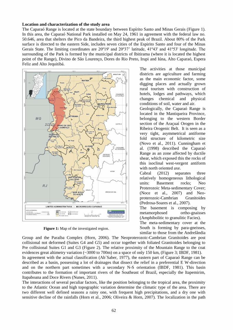
62
Location and characterization of the study area
The Caparaó Range is located at the state boundary between Espírito Santo and Minas Gerais (Figure 1).
In this area, the Caparaó National Park installed on May 24, 1961 in agreement with the federal law no.
50.646, area that shelters the Pico da Bandeira, the third highest peak of Brazil. About 80% of the Park
surface is directed to the eastern Side, includes seven cities of the Espirito Santo and four of the Minas
Gerais State. The limiting coordinates are 20º19' and 20º37’ latitude, 41º43' and 41º53' longitude. The
surrounding of the Park is formed by the municipal districts of Ibitirama (where it is located the highest
point of the Range), Divino de São Lourenço, Dores do Rio Preto, Irupi and Iúna, Alto Caparaó, Espera
Feliz and Alto Jequitibá.
The activities at those municipal
districts are agriculture and farming
as the main economic factor, some
digging places and actually grown
rural tourism with construction of
hotels, lodges and pathways, which
changes chemical and physical
conditions of soil, water and air.
Geologically, the Caparaó Range is
located in the Mantiqueira Province,
belonging to the western Border
section of the Araçuaí Orogen in the
Ribeira Orogenic Belt. It is seen as a
very tight, asymmetrical antiforme
fold structure of kilometric size
(Novo et al., 2011). Cunningham et
al. (1998) described the Caparaó
Range as an zone affected by ductile
shear, which exposed this the rocks of
this isoclinal west-vergent antiform
with north oriented axe.
Cabral (2012) separates three
relatively homogeneous lithological
units: Basement rocks; Neo
Proterozoic Meta sedimentary Cover;
(Noce et al., 2007) and Neo-
proterozoic-Cambrian Granitoides
(Pedrosa-Soares et al., 2007).
The basement is composing by
metamorphosed ortho-gnaisses
(Amphibolitic to granulitic Facies).
The meta-sedimentary cover at the
South is forming by para-gneisses,
similar to those from the Andrelândia
Group and the Paraíba Complex (Horn, 2006). The Neoproterozoic-Cambrian Granitoides are post
collisional not deformed (Suites G4 and G5) and occur together with foliated Granitoides belonging to
Pre collisional Suites G1 and G3 (Figure 2). The relative proximity of the Mountain Range to the coat
evidences great altimetry variation (~3000 to 700m) on a space of only 150 km, (Figure 3; IBDF, 1981).
In agreement with the actual classification (Ab´Saber, 1977), the eastern part of Caparaó Range can be
described as a basin, possessing a lot of drainages that dissect the relief in a preferential E W-direction
and on the northern part sometimes with a secondary N-S orientation (IBDF, 1981). This basin
contributes to the formation of important rivers of the Southeast of Brazil, especially the Itapemirim,
Itapaboana and Doce Rivers (Nunes, 2011).
The interactions of several peculiar factors, like the position belonging to the tropical area, the proximity
to the Atlantic Ocean and high topographic variation determine the climatic type of the area. There are
two different well defined seasons a rainy one, with frequent high precipitations, and a dry one with
sensitive decline of the rainfalls (Horn et al., 2006; Oliveira & Horn, 2007). The localization in the path
Figure 1: Map of the investigated region.

63
of currents of polar origin is also influenced the situation, which evidence the significant differences
between the maximum temperatures registered in the summer and the lowest in the winter.
This show the importance of relief variation as an important factor in the annual temperature distribution
of the area, determining for winter low to very low temperatures and not permitting very high daily
maxims in the summer. For the lowest attitudes the temperature keep around 24ºC and decreases to higher
ones, getting to be inferior than 0ºC at the Instituto Brasileiro de Defesa Florestal (IBDF, 1981) summit.
Objective
The evaluation of the natural state of river water at the Caparaó Range is an objective of this work. Its
surroundings, by the determination of the concentrations of selected indicator elements (Al, Ba, Ca, Cd,
Cr, Cu, Co, F, Mg, Mn, Ni, Pb, Ti, and Zn), together with the evaluation of physiochemical factors, such
as pH, temperature, dissolved oxygen, turbidity, electric conductivity and resistivity. The variation of
these parameters along the sampled drainages is correlating with geology, vegetation and climate
conditions to obtain background values and indications of intensity and spatial distribution of human
contamination.
Figure 2: Schematic map of the morphologic situation of the Caparaó Range (after Cabral, 2012; modified) ,
including the Park.
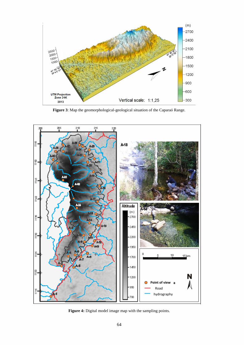
64
Figure 3: Map the geomorphological-geological situation of the Caparaó Range.
Figure 4: Digital model image map with the sampling points.
Point of view
hydrography
Road

65
Methodology
Fifty samples were collecting, in the way to cover completely the studied area. Sixteen samples were
collected in the drought period (October - 2012), and thirty-four in rainy period (March/May - 2013).
Being declared as a Federal Conservation Unit, it is necessary the request authorization of ICMBio
(Institute responsible for Brazilian National Parks), and therefore this research is registered in the
National System of Authorization and Information in Biodiversity (SISBIO), under the number 32142-1.
The sampling conditions follows proceedings using bottles of polyethylene of 500ml, previously washed
with distilled water and the collected sample stabilized in pH with addition of 5ml of HNO3.
The physiochemical parameters (Temperature, Dissolved Oxygen, Turbidity, pH, Electric Conductivity,
Resistivity) measured in situ in the field. The collected samples conditioned in thermal boxes, mitigating
possible current alterations caused by temperature change.
In the process of sample preparation were used 45µm cellulose nitrate filters using vacuum filtration. For
the determinations, it was using a spectrometer of optic emission spectroscopy with docked inductive
plasma torch (ICP-OES) the SPECTRO, at the Laboratory of Environmental Geochemistry (NGqA) of
the Geological Institute of UFMG.
Results
The major part of the analyzed samples from the dry period show chemical values and maximum
physiochemical data in agreement with the established values in the classification of special water at
CONAMA resolution no. 357/2005.
The most samples show also concentration near, or slightly over the detection limit of the used method
(ICP-OES) which are in this case Cr: 0.0417 ppm; Cd: 0.0035 ppm; Zn: 0.0044 ppm; Pb: 0.0801 ppm.
Only Mg values are higher with maximum obtained about 2.336 ppm and the minimum near 0.571 ppm,
for samples collected during the dry period. Some results are showing with the values for point 1 (Figure
4) are 2.335 ppm for Mg, 4.519 ppm for Ca, 2.575 ppm for Fe and 0.2264 ppm for Ni, for sample 6 were
found 0.0714 ppm for Cu and 0.0166 ppm for Mn. The sample 3 (figure 4) showed the highest al value,
0.949 ppm, sample 14 has the highest Co with 0.0442 ppm, 16 for Ba 0.1371 ppm and 8 with 0.0473 ppm
for Ti.
With the support of analytical data is possible to identify the degree and type of human interference in
this region.
The samples collected during the rainy period have higher turbidity as permitted in law (CONAMA
375/2005) and one point have very low resistivity. All points have chemical values below law limits
(CONAMA 375/2005) and sometimes detection limits. The highest values are 0,855 ppm Mg at point 21,
0.25ppm Al, 0.94 ppm Fe and 0.0006 ppm Ba at point 11 and at sampling point 31 0.046 ppm Ti.
It is possible to divide the data in three groups: Environmental pool 1 includes the points with the highest
alterations and higher concentration of elements; environmental pool 2 has a wide spectrum of elements,
without Ni and the concentration near the natural middle values; and the environmental pool 3 show great
a variation on concentration and type of elements.
Some of the determined elements show a peculiar distribution, like Ba with higher concentration in the
valleys of Northern-central part with western-eastern orientation and Ni in river parts with higher
turbidity.
Conclusions
The direct area of Caparaó National Park of doesn't show significant indices of contamination and
samples collected in the Park were in agree with the Brazilian legislation.
It was able to observe a correlation between physical parameters (pH; turbidity) with rock substrate, soil
composition and vegetation. On the eastern side a deposition of air, derived particles can play a role of
composition. The water has a slightly acid, reaction, typical for rain forest waters.
In the surrounding of the Park area water is influenced by different human activities and therefore the
conductivity, pH, turbidity increases and chemical composition differ.
Element concentration (especially Mg, Al, Ca, Fe) varies considerable between rainy (lower) and dry
periods (higher). Trace element concentration show that a monitoring of the areas due to higher human
activities like tourism, agriculture, settling and mining are increasing.
Acknowledgements. Authors thanks to CNPq for financial support and to UFMG and the Federal Park
Administration for logistic help.
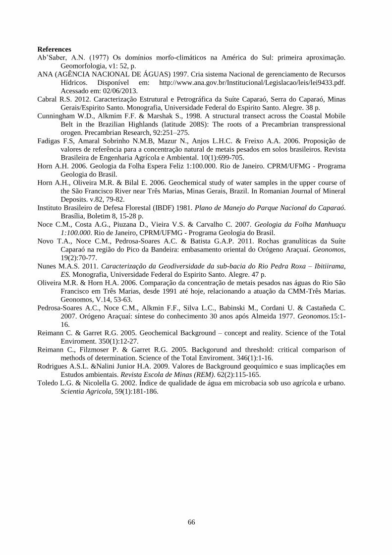
66
References
Ab’Saber, A.N. (1977) Os domínios morfo-climáticos na América do Sul: primeira aproximação.
Geomorfologia, v1: 52, p.
ANA (AGÊNCIA NACIONAL DE ÁGUAS) 1997. Cria sistema Nacional de gerenciamento de Recursos
Hídricos. Disponível em: http://www.ana.gov.br/Institucional/Legislacao/leis/lei9433.pdf.
Acessado em: 02/06/2013.
Cabral R.S. 2012. Caracterização Estrutural e Petrográfica da Suíte Caparaó, Serra do Caparaó, Minas
Gerais/Espirito Santo. Monografia, Universidade Federal do Espirito Santo. Alegre. 38 p.
Cunningham W.D., Alkmim F.F. & Marshak S., 1998. A structural transect across the Coastal Mobile
Belt in the Brazilian Highlands (latitude 208S): The roots of a Precambrian transpressional
orogen. Precambrian Research, 92:251–275.
Fadigas F.S, Amaral Sobrinho N.M.B, Mazur N., Anjos L.H.C. & Freixo A.A. 2006. Proposição de
valores de referência para a concentração natural de metais pesados em solos brasileiros. Revista
Brasileira de Engenharia Agrícola e Ambiental. 10(1):699-705.
Horn A.H. 2006. Geologia da Folha Espera Feliz 1:100.000. Rio de Janeiro. CPRM/UFMG - Programa
Geologia do Brasil.
Horn A.H., Oliveira M.R. & Bilal E. 2006. Geochemical study of water samples in the upper course of
the São Francisco River near Três Marias, Minas Gerais, Brazil. In Romanian Journal of Mineral
Deposits. v.82, 79-82.
Instituto Brasileiro de Defesa Florestal (IBDF) 1981. Plano de Manejo do Parque Nacional do Caparaó.
Brasília, Boletim 8, 15-28 p.
Noce C.M., Costa A.G., Piuzana D., Vieira V.S. & Carvalho C. 2007. Geologia da Folha Manhuaçu
1:100.000. Rio de Janeiro, CPRM/UFMG - Programa Geologia do Brasil.
Novo T.A., Noce C.M., Pedrosa-Soares A.C. & Batista G.A.P. 2011. Rochas granulíticas da Suíte
Caparaó na região do Pico da Bandeira: embasamento oriental do Orógeno Araçuaí. Geonomos,
19(2):70-77.
Nunes M.A.S. 2011. Caracterização da Geodiversidade da sub-bacia do Rio Pedra Roxa – Ibitiirama,
ES. Monografia, Universidade Federal do Espirito Santo. Alegre. 47 p.
Oliveira M.R. & Horn H.A. 2006. Comparação da concentração de metais pesados nas águas do Rio São
Francisco em Três Marias, desde 1991 até hoje, relacionando a atuação da CMM-Três Marias.
Geonomos, V.14, 53-63.
Pedrosa-Soares A.C., Noce C.M., Alkmin F.F., Silva L.C., Babinski M., Cordani U. & Castañeda C.
2007. Orógeno Araçuaí: síntese do conhecimento 30 anos após Almeida 1977. Geonomos.15:1-
16.
Reimann C. & Garret R.G. 2005. Geochemical Background – concept and reality. Science of the Total
Enviroment. 350(1):12-27.
Reimann C., Filzmoser P. & Garret R.G. 2005. Backgorund and threshold: critical comparison of
methods of determination. Science of the Total Enviroment. 346(1):1-16.
Rodrigues A.S.L. &Nalini Junior H.A. 2009. Valores de Background geoquímico e suas implicações em
Estudos ambientais. Revista Escola de Minas (REM). 62(2):115-165.
Toledo L.G. & Nicolella G. 2002. Índice de qualidade de água em microbacia sob uso agrícola e urbano.
Scientia Agricola, 59(1):181-186.

Rom. J. Mineral Deposits, vol. 87 (2014), No. 2, p. 67-70
67
CHEMISTRY OF MINERALS FROM THE AZEGOUR SKARN DEPOSITS,
WESTERN HIGH ATLAS, MOROCCO
Ahmed TOUIL 1, Mohamed HIBTI
1, Essaid BILAL
2, Abdessamad EL KHALILE
1
1Laboratoire Géoressources (Unité associée au CNRST, URAC42), Faculté des Sciences et Techniques Guéliz, BP
549 40010 Marrakech, Morocco (e-mail: [email protected]) 2Ecole Nationale Supérieure des Mines de Saint Etienne, GSE, CNRS UMR 5600, F42023 Saint Etienne, France
(e-mail: [email protected])
Abstract:
The Azegour Cu-Mo deposit, located on the north side of the High Atlas, occurs in lower Cambrian volcanic and
sedimentary rocks. The mineralization of this deposit is directly associated with skarns, developed on carbonate bars
during the intrusion of the calc-alkaline hyperaluminous granite of Azegour. The type of the hydrothermal
transformations recorded in the carbonated bars is controlled by the lithological nature of the protolith and is closely
confining with the volcanic and volcano clastic levels.
Five paragenetic stages of skarn formation and ore deposition can at least be described: Stage I: clinopyroxene;
stage II: wollastonite ± vesuvianite; stage III: garnet; stage IV: quartz ± potassium feldspar ± calcite ± sulphides ±
molybdenite ± cassiterite ± scheelite ± fluorite ± accessory minerals (apatite, zircon, titanite) and stage V:
amphibole ± calcite ± chlorite ± muscovite ± epidote ± sulphides. Two mineralizations stages are identified. The
first stage observed in volcanic and volcano clastic rocks in contact with the dolomitic marble is previous to the
metamorphic and structural events and consists essentially of sulphides and sulfo-arsenides (Cu, Pb, Zn, As and Ag).
The second stage of mineralization (Mo, W and Sn) is observed in the skarn from marble of granitic metamorphic
aureole.
Keywords: skarn, mineralization, mMetasomatic, Azegour, High-Atlas, Morocco, Cu, Mo deposit.
INTRODUCTION
The Azegour Cu-Mo skarns deposit, located about 60 km in the SW of Marrakesh city and about 20 km
southwest of the Amizmiz village (Fig. 1), is one of many base and precious metal deposits hosted in the
Palaeozoic formations of the north side of the western High Atlas.
It was exploited for the first time in 1921, for copper and thereafter for molybdenum between 1930 and
1946, with an annual average of 200t/j of concentrate with 85% of MoS2. The reserves have been
estimated at 1.4 to 1.5 Mt ore with 0.2 to 0.7% MoS2, 2 Mt of ore with 0.4% WO3 and 1 Mt of ore with
1.4 to 2.8% Cu. The exploitation works ceased in 1972 but the increase of metal courses in these last
years contributed to undertake researches on the site in the perspective of the reopening of the mine in the
future.
1. GEOLOGICAL SETTING
The regional geology of the Azegour area is marked by a lower Cambrian volcano-sedimentary serie
consisting of lava flow and pyroclastites, sandstone-mudstone rocks interlayered with volcanic and
pyroclastic rocks, limestone bars and lenses inter-layered with thin pelitic, volcanic and pyroclastic bands
or lenses, andesitic flow inter-layered with pelite and volcanic lies (El Khalile et al., 2014). The middle
Cambrian is essentially composed of sandstone and pelite (Permingeat, 1957; and Badra et al. 1992).
Those Cambrian series are unconformable overlain by the Cretaceous-Tertiary sub-atlasic series. The
magmatic activity of Azegour is linked to a volcanic arc context, previously to the Cambrian extension.
According to El Khalil et al. (2014) this magmatic activity is a continental intra-plate tholeiite, widely
described in the lower Moroccan Cambrian (Badra et al., 1992, Piqué et al., 1995; Ouali et al., 2000).
During the magmatism of late hercynian orogeny, small plutons of granite, granodiorite, including the
intrusive rocks of Azegour, and other felsic rocks were formed. The Azegour pink granite outcrop is
irregular in shape and extends NNW–SSE (Fig. 1), of about 7 km long and 1 km wide, representing a
stock that is inclined to the southeast. This Azegour intrusion has a Permian Rb-Sr age (271 ± 3 Ma)
(Mrini et al., 1992). From a chemical point of view, the granite is a K-alkaline hyperaluminous granite of
crustal origin (S-type granite) (El Khalile et al., 2014). The calc-alkaline granites of Azegour are
associated to molybdenum granites type (El Khalil et al., 2014).
68
Figure 1: Map of Azegour area; the lower Cambrian volcano-sedimentary series are cut by Permian granites (El
Khalile et al., 2014).
Like their counterparts in the Moroccan Palaeozoic massifs, the formations of Azegour have undergone
the effect of the major hercynian deformation predating the granite intrusion. Late phases were also
described in the area (Ait Ayad et al., 2000).
A thermal metamorphism related to the granite intrusion overlaps the general metamorphism of low
grade, which affects the Palaeozoic series of Azegour. It develops a metamorphic aureole of about 1.5 km
in the host rocks (Permingeat, 1957). The thermal metamorphism induces recrystallization of carbonate to
variant degree (cipolin) with dolomite always as major phase and diopside, humite, green spinel and
occasionally scapolite. Other minerals present are quartz, muscovite, also rare ilmenite, and pyrite.
Hydrothermal transformations (skarnification) overlap this purely thermal early stage and lead to the
formation of pyroxenites, wollastonitites, and garnetite, accompanied with Cu, Zn, Mo and W
mineralizations.
2. SKARN MINERALOGY
The Cambrian series at Azegour contains four main lens-shaped carbonated bars with variable size, east-
west oriented, as follow (El Khalile et al., 2014) : the central bar which has been the object of the old
exploitation for copper and molybdenum, the west-central bar, the bar of Sidi Yahia and that of Toulkine
situated further to west. The present work carries on the central bar, west-central bar and that of Sidi
Yahia which record the maximum of hydrothermal transformations.
In detail, the studied carbonated bars show a heterogeneous composition, varying from pure dolomite,
with a few clasts of quartz, to dolomites with pelitic, volcanic and pyroclastic fractions. The type of the
hydorthermales transformations recorded in the carbonated bars is controlled by the lithologic nature of
the protolith and is closely confined with the volcanic and volcanoclastic levels.
Petrographical and mineralogical textures allow to recognize at least five hydrothermal stages (El Khalile
et al., 2014). Early minerals are largely anhydrous, whereas later ones are predominantly hydrous:
Stage I: clinopyroxene
Stage II: wollastonite ± vesuvianite
Stage III: garnet
Stage IV: quartz ± potassium feldspar ± calcite ± sulphides ± molybdenite ± cassiterite ± scheelite ±
fluorine ± accessory minerals (apatite, zircon, titanite)
Stage V: amphibole ± calcite ± chlorite ± muscovite ± epidote ± sulphides.
These transformations draw a well-defined zoning, which repeats at the level of every skarnified bar or
carbonated lens. So, from granite (proximal zone) towards the host rock (distal zone), they can be
described: Pyroxenites → Wollastonite ± vesuvianite → Garnetite → Quartz ± potassium feldspar ±
mineralizations. To these prograde transformations can succeed retrograde transformations inducing the
formation of amphibole, epidote and chlorite.

69
The economic mineralizations of Azegour are represented mainly by local concentration of chalcopyrite
and molybdenite associated with scheelite, sphalerite, galena, pyrite, pyrrhotite, and magnetite. Grey
copper and silver appear as traces. Some bismuth, uranium and beryllium minerals were also described
by Permingeat (1957). The suphides were oxidized at the surface and subsurface and altered to covellite,
malachite, azurite, limonite and hematite. The skarn mineralizations occur as irregularly shaped clusters,
pods or thin lenticular bands, following compositional banding. They are most often linked to garnetites.
3. MINERAL CHEMISTRY OF THE SILICATE SKARN
In the Azegour deposit, the zonal distribution of the skarn mineral assemblage and mineral composition is
very conspicuous. A comprehensive description of the skarn mineral paragenesis is given by El Khalile et
al. (2014). Compositional variations of skarn minerals in the different ore-bearing skarn zones are
described in the following paragraphs.
3.1 Clinopyroxene
The chemical compositions of the Azegour pyroxenes are summarized in figure 2. Clinopyroxene is
essentially a binary diopside–hedenbergite phase with XMg ratio ranging from 32.45 to 39.82 in diopside
and from 12.02 to 26.07 in hedenbergite; other constituents are Mn, nearly 0.3 wt.% (0.24 to 0.5 wt.%),
Al nearly 3 wt.% in diopside and less than 1,59 wt.% in hedenbergite. Clinopyroxene is generally
compositionally homogeneous in individual zones.
Figure 2: Ca-Al-(Fe+Mn+Mg) diagram showing the chemical composition of minerals from the Azegour skarns.
3.2 Garnet
The compositions of garnet are summarized in figure 3. The proportions of nominal end member
molecules were computed after calculating Fe2+
/Fe3+
ratio, assuming that (AlVI
+Ti+Cr+Fe3+
) = 2 per
formula unit (p.f.u., 12 oxygen atoms) (Pan and Fleet, 1992).
According to the colour and the chemical composition, four types of garnets can be distinguished:
1- Brown to orange grossular type; Ca2.33-3.1(Fe2+
0-0.37Mg0-0.44Mn0-0.08) (Al1.37-1.92Fe3+
0-0.3) (SiO4)3
2- Dark green andradite type; Ca2.96-3.1(Fe2+
0.47-0.51Mg0-0.01Mn0.02-0.03) (Al0.05-0.14Fe3+
1.58-1.68) (SiO4)3
3-Yellowish green to brow-green grandite (garnet of intermediate composition between grossular and
andradite); Ca2.76-3.11(Fe2+
0.08-0.57Mg0-0.07Mn0-0.02) (Al0.49-1.55Fe3+
0.38-1.3) (SiO4)3
4-Brown red grossular - almandine garnet Ca1.59-1.99(Fe2+
0.79-1.09Mg0-0.05Mn0-0.02) (Al2.032.56Fe3+
0) (SiO4)3

70
Figure 2: Chemical composition of garnet from the Azgour skarns.
3.3 Wollastonite and vesuvianite
The chemical composition of wollastonite is pure (Ca5.78-6.02Si5.96-6.02O18) with a low content of Mg, less
than 0.2 wt % Fe and Mn less than 0.1 wt%. Two types of vesuvianite were described (El Khalile et al.,
2014). The brownish one is formed in prograde stage and is rather rich in Al, Ti and Mg than the late
retrograde greenish one, which is rich in Fe.
ACKNOWLEDGEMENTS
This work was supported by Laboratoire Géoressources (Unité associée au CNRST, URAC42), Faculté des Sciences
et Techniques Guéliz, Marrakech, Maroc and Geosciences & Environment Department (CNRS, UMR 5600) of
Ecole Nationale Supérieure des Mines de Saint Etienne, France.
REFERENCES
Ait Ayad, N., Ribeiro, M.L., Sola, A.R., Moreira, M.E., Dias, R., Bouabdelli, M., Ezzouhri, H. & Charf, A., 2000.
Azegour granite (Maroc): geochemical mapping and geodynamic interpretation. Communicaçaos do Instituto
Geologico e Mineiro, 87, 155-164.
Badra, L., Pouclet A., Prost A.E. & Touray J.C., 1992. Mise en évidence d’une extension intra-plaque tardi-
panafricaine d’intérêt métallogénique dans le Haut-Atlas occidental (Maroc). Comptes Rendus Académie
Sciences, Paris, 314, 703-709.
El Khalile A., Touil A., Hibti M. & Bilal E., 2014. Metasomatic zoning, mineralizations and genesis of Cu, Zn
and Mo Azegour skarns (Western High Atlas, Morocco) : Carpathian Journal of Earth and Environmental
Sciences, Vol. 9, No. 1, p. 21 - 32 Mrini, Z., Rafi, A., Duthou, J.L., & Vidal, P., 1992. Chronologie Rb-Sr des granitoïdes hercyniens du Maroc:
conséquences. Bulletin Société Géologique France, 163, 3, 281-291.
Ouali, H., Briand, B., Bouchardon J. L., & El Maataoui, M., 2000. Mise en évidence d’un volcanisme alcalin
intraplaque d’âge Acadien dans la Meseta nord-occidentale (Maroc). Comptes Rendus Académie Sciences,
Paris, 330, 611-616.
Pan, Y., Fleet, M.E., 1992. Mineralogy and genesis of calc-silicates associated with Archean volcanogenic massive
sulfide deposits at the Manitouwadge mining camp, Ontario. Canadian Journal of Earth Sciences 29, 1375–
4388.
Permingeat, F., 1957. Le gisement de molybdène, tungstène et cuivre d’Azegour (Haut Atlas): Etude pétrographique
et métallogénique. Notes Mémoires Services Géologiques Maroc, pp. 141.
Piqué, A., Bouabdeli, M. & Darboux, J., R., 1995. Le rift cambrien du Maroc occidental. Comptes Rendus
Académie Sciences, Paris, 320, IIa, 1017-1024.

Rom. J. Mineral Deposits, vol. 87 (2014), No. 2, p. 71-74
71
THE USE OF DIMENSION STONE CUT RESIDUAL IN AGRICULTURE SOIL
CORRECTION. AN EXAMPLE FROM ESPIRITO SANTO STATE, BRAZIL
Alexandre Sylvio Vieira DA COSTA1,3*
, Adolf Heinrich HORN2
1 – ICET – UFVJM, Teófilo Otoni-MG, Rua do Cruzeiro, n.01, Jardim São Paulo.
2 - NGqA-IGC-UFMG, Belo Horizonte-MG, Av. Antônio Carlos, 2766, [email protected]
3 - Postgraduation – UFMG-IGC, Belo Horizonte-MG, Av. Antônio Carlos, 2766,
Abstract Dimension stone production produce a huge amount of semiliquid waste which contaminates water, air
and produce also a visual impact. This fine material has high content of mineral salts and other nutrient. Greenhouse
test show that its application increases the nutrients of poor soil and permit to obtain better harvests.
Key words: Environmental impact, dimension stone production, lateritic soils, fertilizer, agriculture
1. Introduction
From literature is well known the use of industrial waste in different application to reduce environmental
impacts. One of these applications is “rochagem” in agriculture (Fontes, 2001). This work shows the
applicability of waste material from dimension stone production at Espírito Santo State. Espirito Santo,
Minas Gerais and Bahia are the most important producers of Dimension Stones of Brazil. The principal
produced materials can be observed from the map of Figure 1. The average annual production of dry
residual material by these units is about 165.000 t/y in Espirito Santo State (Brazil ~240.000 t/y;
FLUXGEO, verb. com.).
Figure 1. Map of the South-Eastern region of Brazil showing Espirito Santo- and parts of Minas Gerais and Bahia
States. The arrow indicates de province capital and center of Dimension Stone Production. The shaded
area indicates the principal quarries occurrences.
These materials are principally composed of all type of intrusives (gabbro, granites s. l.),
metamorphic rocks like gneisses, migmatites, marbles and quartzites. In Table 1 are shown the
compositions of the explored rocks and their average compositions. The waste material represents 20 –
25 Vol% of the whole worked dimension stones and is composed of rock powder, polishing material,
quartz sand, limestone, oil and lubrication products, metal powder and parts of the saws and polishing
equipment in a semiliquid stage (15-25% water). This water is separated during maturation of the piles
and contaminates the environment. Fine powder is liberated after drying and cause air pollution.

72
Table 1. Average values of elements concentration in the rock powder of the three investigated producers tested for
use in agriculture.
2. Environmental problems
The waste material is always deposited in the surroundings of the saws and facilities, normally in active
river valleys and closed depressions, often without isolation from the groundwater levels. Therefore the
environmental problems consist in water contamination and air dust pollution.
3. Methods and materials
To be able to use this material for agriculture purposes, a specific grain size is very important (Table 2)
because influences the agro-specific chemical parameters, like pH, Fetot, nutrient content and percolation
velocity in the soil-waste system. The Table 3 shows the nutrient content and chemical parameters of the
used soil material.
Table 2. Grain size composition of an average sample of the discarded material from the three industries
Table 3. Chemical and soil parameters of the used soil material.
After these preliminary analyses, field experiments were done with three typical Brazilian cultures (beans
- Phaseolus vulgaris L.; corn - Zea mays L.; grass - Brachiaria decumbens) with different root depths at
the experimental area of UNIVALLE at Governador Valadares.
4. Production process
After cutting the rocks in the quarries, the blocks are transported to the stone saws and afterwards to the
grinding and polishing tables (Figure 2).
5. Results
The results of filtration test are shown in Figure 3, respectively together with the soil-waste properties.
All field tests show good results of physical properties for plants grown with the use of the waste material as
compared with samples grown without it (Figure 4).

73
Figure 2. Pictures showing a typical quarry, saw and polishing place. In the places where the waste material is
deposited the water content lowers from 80% to 20%. A. Quarry; B. Deposit of blocks; C. Saw; D.
Polishing process.
Figure 3. Diagrams representing all chemical parameters for the different soil – waste applications for the
investigated four industries for different quantities of waste application.
Quadrangles: Katugran; Triangles: Marbrasa polishing; Lozenges: Limagran cutting+polishing;
x: Marbrasa cutting;
A B
C D

74
Figure 4: Diagrams of plant evolution with application (dry material).
Left: Whole corn plant (without cobs)
Right: Only grains
Quadrangles: Limagran cutting+polishing; Triangles: Marbrasa polishing; Lozenges: Marbrasa
cutting;
6. Conclusions and discussions
These results show that the waste material from stone saws and mill can be used due to its composition as
correctives and sometimes as fertilizer in agriculture. The example can serve for all countries which have
dimension stone production.
7. Acknowledgements
The authors thank the UFMG, UNIVALE and FAPEMIG for logistical and financial support. The
Association of dimension stone producers supported the fieldwork and gave important informations.
8. Reference Fontes R.L.F., 2001. Avaliação da eficiência de material calcário de origem industrial (Usiminas) como corretivo da
acidez do solo para agricultura. Relatório Técnico. UFV, Viçosa, MG. 40p.

Rom. J. Mineral Deposits, vol. 87 (2014), No. 2, p. 75-78
75
CHANGES IN THE P-CONCENTRATION IN BRAZILIAN SOILS AFTER APLICATION OF
WASTE MATERIAL FROM DIMENSION STONE PRODUCTION, BRAZIL
Alexandre Sylvio Vieira DA COSTA1, Adolf Heinrich HORN
2*, Amando de Pinho AGUIAR
3
1 - ICET – UFVJM, Teófilo Otoni-MG, Rua do Cruzeiro, n.01, Jardim São Paulo; [email protected]
2 - NGqA-IGC-UFMG, Belo Horizonte-MG, Av. Antônio Carlos, 2766, *[email protected]
3 - Postgraduation – UFMG-IGC, Belo Horizonte-MG, Av. Antônio Carlos, 2766,
Abstract
The use of rock powder from the dimension stone production based on apatite rich igneous rocks is used in this
study to enhance the soil quality of poor lateritic soils existent in the Southeastern region of Brazil. The use of this
corrective material increases significantly the P-availability in the soil. The material was used in greenhouse- and
Freeland tests to increase the grass production and its nutrient quality. In this way the amount of meat and milk
products from cattle raising increases and the waste deposits reduces.
Keywords: Phosphorous, soil quality, corn production, environmental impacts
Introduction
According to Acre (2004), solid residue or waste is any substance or discarded material resulting
from human or animals activities or sometimes of natural phenomena. It is normally in solid or semi-solid
state and includes particulate material.
The solid residues are originated by different human activities, such as metallurgy, chemistry,
petro-chemistry, and paper- and food industry among others.
They vary and could be represented by ashes, muds, oils, plastics, you eat, wood, fibers, chemicals,
metals, scums, glasses, and more (Naumoff & Peres, 2000), normally deposited in big waste deposits
causing longtime environmental problems. The involved costs are very high due to preparation and
maintaining of these deposits to prevent soil, water and air contamination.
In the case of dimension stone production, more than 20% sometimes up to 50% of rock mass is
transformed in waste paste by cutting and polishing (Moreira et al., 2003), classified like inert residue
class III. Therefore this industry creates a great environmental impact which could be reduced by using of
this waste in agriculture.
Brazil is passing a crisis due to low international prices of agricultural products, and high national
costs caused by expensive fertilizer importation.
Therefore the search for alternatives for fertilization and correcting of the soils of farming, pastures
and plantations and to reduce the dependence of these imports is a fundamental piece for the development
of agriculture in Brazil by reduction of the production costs.
In the future agricultural activities may have an important participation in the recycling and
integration of the industrial materials (s. l.) with introduction in the biological systems, with special view
to nutrient rich waste materials (Harter, 1979; King, 1988).
Methodology The experiments have been carried out in the greenhouses of the Vale do Rio Doce University at
Governor Valadares, MG. For the experiments PVC-tubes of 9.5cm diameter and 35 cm heights have
been used. The used soil was collected from textural B-horizon of a red-yellow dystrophic argisoil.
Pasty waste from dimension stone production (mainly granites; gabbros and charnockites) from
sawmills localized at Cachoeiro de Itapemirim, Espírito Santo State were used.
The material was collected at filtration lakes of the three companies (Katugran, Limagran and
Marbrasa), dried in laboratory to values <4% humidity, crushed and sieved for greater particle uniformity.
These samples were analyzed and the results are given in Table 1.
The prepared residues were added to the surface of soil filled tubes with different soil-waste
relation of 5t/ha, 10t/ha; 20t/ha and 40t/ha, respectively, together with a blind sample (0t/ha) calculated
by real tube surface. Then water was added up to 80% of capacity and maintaining for 30 days
applications of 20% of capacity.
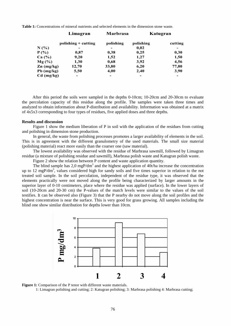
76
Table 1: Concentrations of mineral nutrients and selected elements in the dimension stone waste.
After this period the soils were sampled in the depths 0-10cm; 10-20cm and 20-30cm to evaluate
the percolation capacity of this residue along the profile. The samples were taken three times and
analyzed to obtain information about P-distribution and availability. Information was obtained at a matrix
of 4x5x3 corresponding to four types of residues, five applied doses and three depths.
Results and discussion Figure 1 show the medium liberation of P in soil with the application of the residues from cutting
and polishing in dimension stone production.
In general, the waste from polishing processes promotes a larger availability of elements in the soil.
This is in agreement with the different granulometry of the used materials. The small size material
(polishing material) react more easily than the coarser one (saw material).
The lowest availability was observed with the residue of Marbrasa sawmill, followed by Limagran
residue (a mixture of polishing residue and sawmill), Marbrasa polish waste and Katugran polish waste.
Figure 2 show the relation between P content and waste application quantity.
The blind sample has 2,0 mgP/dm3 and the highest application of 40t/ha increase the concentration
up to 12 mgP/dm3, values considered high for sandy soils and five times superior in relation to the not
treated soil sample. In the soil percolation, independent of the residue type, it was observed that the
elements practically were not moved along the profile being characterized by larger amounts in the
superior layer of 0-10 centimeters, place where the residue was applied (surface). In the lower layers of
soil (10-20cm and 20-30 cm) the P-values of the match levels were similar to the values of the soil
testifies. It can be observed also (Figure 3) that the P nearby do not move along the soil profiles and the
highest concentration is near the surface. This is very good for grass growing. All samples including the
blind one show similar distribution for depths lower than 10cm.
Figure 1: Comparison of the P tenor with different waste materials.
1: Limagran polishing and cutting; 2: Katugran polishing; 3: Marbrasa polishing 4: Marbrasa cutting;

77
Figure 2: Relation between P content in soil and quantity of waste application.
1: 0t/ha; 2: 5t/ha; 3; 10t/ha 4: 20t/ha 5: 40t/ha;
Figure 3: Relation between P-concentration and depths. Middle values for the three industries.
1: 0-10cm; 2: 10-20cm; 3: 20-30cm;
Figure 4: Comparison between P-concentration, soil-depth and industry. The behaviour is near
similar. Differences are caused by the different liberation ratio of the saw and polishing
material, due to experiment duration time.
1. Limagran polishing and cutting; 2. Katugran polishing; 3. Marbrasa polishing; 4.
Marbrasa cutting;
Left column: 0-10cm; middle column: 10-20cm; right column: 20-30cm;

78
Conclusions The residues of ornamental rocks production, mainly from granites, charnockites and gabbros,
show a high potential to promote the increase of the P-levels of soils, especially near the surface in the
upper 10cm.
The finer material (polishing residues) shows a more rapid and complete activity, than the coarser
one (sawmill waste). Therefore grinding may be an interest preparation process.
Due to a low mobility the action is very locally, limited to upper parts and annual applications.
Acknowledgements
The authors thank the UFMG, UNIVALE, CNPq and FAPEMIG for logistical and financial
support. The Association of dimension stone producer supported the fieldwork and gave important
informations.
References Acre-Secretária De Estado De Meio Ambiente E Recursos Naturais, 2004. Inventário de resíduos sólidos
Industriais do Estado do Acre. Secretaria de Estado de Meio Ambiente e Recursos Naturais. Rio
Branco: 23p.
Harter R.D., 1979. Adsorption of copper and lead by Ap and B2 horizonts of several Northeastern United
States Soils. Soil Sci. Soc. Am. J. 43: p679-83,
King L.D., 1988. Retention of metals by several soils of the Southeastern United States. J. Environ. Qual.
17 (2): p239-460.
Naumoff A.F. and Peres C.S., 2000. Reciclagem de matéria orgânica. In: D Almeida M.L.O; Vilhena A.,
2000. Lixo Municipal: Manual de Gerenciamento Integrado. São Paulo: IPT/CEMPRE.
Moreira J.M.S., Freire M.N. and Holanda J.N.F., 2003. Utilização de resíduo de serragem de granito
proveniente do estado do Espírito Santo em cerâmica vermelha. Cerâmica, 49: p262-267.
Rom. J. Mineral Deposits, vol. 87 (2014), No. 2, p. 79-82
79
USO REACTION PRODUCTS OF BATTERY ACID FROM CARS AND CELLULOSE WASTE
FROM INDUSTRY AS A NEW FERTILIZER FOR CORN CULTIVATION (Zea mays L.)
ON POOR SOILS, ON AN EXAMPLE FROM GOVERNADOR VALADARES
IN MINAS GERAIS, BRAZIL
Alexandre Sylvio Vieira DA COSTA1, Adolf Heinrich HORN
2, Amando de Pinho AGUIAR
3
1 – ICET – UFVJM, Teófilo Otoni-MG, Rua do Cruzeiro, n.01, Jardim São Paulo; [email protected]
2 - NGqA-IGC-UFMG, Belo Horizonte-MG, Av. Antônio Carlos, 2766; [email protected]
3 - Postgraduation – UFMG-IGC, Belo Horizonte-MG, Av. Antônio Carlos, 2766,
Abstract: Industry produces a big amount of contaminated sulfuric acid (H2SO4). After cleaning with micro pore filters the
acid is neutralized against CaCO3 solutions from paper industry producing CaSO4. Greenhouse tests show the good
performance of this material in agriculture, reducing Al activity, increasing nutrient are more available for the
plants. In this way waste deposits are reduced and import costs for fertilizer are reduced as well.
Keywords: Industrial waste, sulfuric acid, environmental impacts, fertilizer
Introduction
Every country in a globalized world has to struggle against high importation prices of raw materials,
world defined alimentation prices, high costs of environmental prevention and mitigation together with
the imposition of political-economic facts.
In this sense to create the possibility to lower food costs, enhance the exportation balance and reduce
environmental impacts are all very important things.
The possibility to use sulfur acid of batteries and waste from paper mills to produce fertilizer is included
in this purposes.
Fertilizers are very important for acid lateritic soils poor in Ca, K, S, P and rich in Fe, Al and Si
(Brasilagro, 2011; Collings, 1955).
Sulfuric Acid
The sulfuric acid from batteries is a strong acid enriched in heavy metals dangerous for the life. The total
production in 2001 was 165 x106t used in diversificated industry and afterwards liberated to the streams
and air.
In fertilizer production (60% of world use) the concentration of H2SO4 is about 70% and in batteries
~33,5%.
Cellulose production
Cellulose production in Brazil is increasing rapidly (Ribeiro, 2007; Bracelpa, 2010) showing for 2009
13,5x10⁶t. Brazil with its extended areas of forests is the fourth world producer of this material. The
production of cellulose has as result a big amount of Ca(OH)2 s.l. which can create a big environmental
problem.
Methodology
Solid samples were collected from a cellulose and paper industry and the contaminated acid from a
recycling industry; both at Governador Valadares, MG. Table 1 shows the composition of these two raw
materials.

80
Table 1. Chemical composition of the substances used in the work.
The material was transported to the laboratory of industrial waste research for the purpose of preparing
and reaction processing. Figure 1 shows a scheme of the process.
Figure 1. The flow scheme showing the pre-treatment and chemical-physical process for CaSO4 production (Piotto,
2003; Almeida et al., 2010)
At the end of the process the material is send to the greenhouse experimental area of UNIVALE
agronomic department. There the experiments were realized in pots filled with lateritic soil and different
ratios of the CaSO4 produced by the process (Figure 1).

81
Figure 2. The different stages of evolution of plants with and without addition of CaSO4.
Samples are taken periodically from the soil and plants to evaluate possible contaminations with heavy
elements from the protholiths.
Results and discussion
– The use of this material allows a better growth of the corn plants (Figure 2).
– The root evolution (rhizome?) is much better and more rapid. The roots reach deeper levels inf soil and
more contact volume, too, in agreement with Raij (1988) and Sichmann et al. (1982).
– The use in agriculture can nearby absorbs the whole acid and residual of cellulose production and
reduces in this way water and soil contamination as well as the waste deposits volume on the surface.
– No significant heavy element concentrations were found in eatable parts of the plants.
Acknowledgement
The authors thank the UFMG, UNIVALE, CNPq and FAPEMIG for logistical and financial support.
References
Almeida, A.M., Pinheiro, A.G.O., Carneiro, R.; Silva, R.C., 2010. Processos limpos no branqueamento da
polpa celulósica. Available at:
http://www.google.com.br/url?sa=t&source=web&cd=1&ved=0CBYQFjAA&url=http%3A%2F%
2FFww.ebah.com.br%2Fproducao-limpa-no-processo de branqueamento-de-celulose-pdf-
a10048.html&ei=sbbiTPS BHMH58AbV_fngDA&usg=AFQjCNGcx8O 1u2MaFBuz75
V2n9Nd9WiDA. Accessed at: 27.08. 2010
BRASILAGRO, 2011. Mercado de fertilizantes no Brasil. Available at:
http://brasilagro.wordpress.com/2011/09/17/mercado-de-fertilizantes-no-brasil/. Accessed at:
27.02. 2012.
BRACELPA, 2010. Associacao brasileira de celulose e papel. Available at:
http://www.bracelpa.org.br/bra2/index.php. Accessed at: 03.10. 2010.

82
Collings, G.H., 1955. Comercial fertilizants. 5ª ed. Mc Graw Hill Book Co.
Piotto, Z.C., 2003. Eco-eficiência na indústria de celulose e papel. PhD thesis – Universidade de Sao
Paulo, Sao Paulo. 357 p.
Raij, B.V., 1988. Gesso agrícola na melhoria do ambiente radicular no subsolo. São Paulo. Associação
Nacional para difusão de Adubos e Corretivos Agrícolas: 88p.
Ribeiro, R.N., 2007. Utilização de redes neurais artificiais e tecnologia ft-nir para predição do número
kappa em um processo kraft de cozimento de madeira em indústria de celulose. MSc thesis. Centro
Universitário do Leste de Minas Gerais, Coronel Fabriciano.147p.
Sichmann, W., Neptune, A.M.L., de Melo, F.A.F., 1982. Efeito da aplicação de calcário e gesso na
produção de vagens e sobre algumas características dos frutos de amendoin (Arachis hypogea) em
experimento conduzido em vasos contendo um solo podzolizado de Lins e Marília. Annals of
ESALQ, 39: p337-347.

Rom. J. Mineral Deposits, vol. 87 (2014), No. 2, p. 83-86
83
GEOCHEMISTRY OF SOLID EFFLUENTS AND PHOSPHATE ORE WASHED FROM
MÉTLAOUI-GAFSA BASIN, TUNISIA
Ines GALFATI1, Essaid BILAL
2, Hassan ABDALLAH
1, Aicha BEJI SASSI
1
1 ISSTE - Institut Supérieur des Sciences et Technologies de l'Environnement de Borj Cédria Technopole, Tunisia
2 Ecole Nationale Supérieure des Mines, Géosciences & Environnement Département, CNRS UMR5600, F-42023
Saint Etienne, France ([email protected]).
Abstract. The effluent and washed ore show that treatment of ore enrichment is not aggressive. The results are
supported by the projection factor, which clearly show the relationships between different elements and
mineralogical composition of the effluents and washed ore. The results are a high concentration of 26-35% P2O5
(fluorapatite), but it remains carbonates (calcite and dolomite) in low quantity. The apatite show significant REE
contents that can be by-product of phosphoric acid. Silicates and carbonates are the major part of effluents. The
sulphate and fluoride contents are of the order of 3%, and the Na2O content varies between 1 and 1.5%, we observed
a good correlation between F-P2O5-Na2O-P2O5 and P2O5-SO3 The levels of Cd, Zn, Cr, V, Ni, Sc, Nb and Cu are
from the laundry reject. The maximum values of these elements are in the effluent from the M'DHILLA laundry.
The Cd and Zn are found in high concentrations in the solid effluent. The high Cr content is linked with hydro
cyclones in chromed steel. The washed phosphate ore was strongly depleted in heavy metals, which were
concentrated in the fine fraction released into the hydric network and are thus the main cause of pollution in the
region.
Keywords: phosphate ores, solid efluents, geochemistry, Tunisia
1. INTRODUCTION
MÉTLAOUI GAFSA Basin, with areas of exploitation of MÉTLAOUI, REDEYEF EDDOUR KEF,
MOULARÈS and JELLABIA (Figure 1), is the most important phosphate mining center in Tunisia and is
operated by the GAFSA Phosphates Company (CPG). The enrichment of the wet laid phosphate ore and
the laundry is done in hydro-cyclones, installed near the production centers. The effluents are present as a
fine-grained muds (<70 microns) composed of a small fraction of phosphate, calcite, dolomite, silica,
cherts, sulfides and clays. They are discharged into rivers. In this work, we tried to identify these effluents
and their degree of nuisance on the environment.
2. MATERIALS AND METHODS
Mineralogical proportions of samples of mud were determined by X-ray powder diffraction
(XRD with a Pan-Analytical brand X’ PERT PRO type) carried out at the Laboratory of the Mineral
Resources and Environment of the Faculty of Sciences of Tunis. Argillaceous minerals determination was
based on oriented clay slides, using three preparations (untreated, glycolated and heated one hour at
550°C). Mud samples were also analyzed by XRF (X-Ray Fluorescence) for major elements (P, Ca, Si,
Al, Fe, Mg, Na, K, and Ti) and ICP-AES (Inductive Coupled Plasma Atomic Emission Spectrometry
Activa–Horiba Jobin Yvon Spectrometer) for trace elements (Cd, Zn, Cr, Cu, Ni and Sr) in the
Geosciences & Environment Department of Ecole Nationale Supérieure des Mines de Saint Etienne.
3. RESULTS
3-1. Mineralogy
Enriched ore from the processing units in Zone L1, Métlaoui 3 and Kef Eddour has a high content
of apatite, between 73 and 76% (Table 1). The minerals not eliminated as dolomite, calcite and quartz
have low contents and variable with a maximum of 15%. However, the mineralogical composition of
effluents includes the same minerals as the products sold (apatite, dolomite, calcite, quartz, opal-CT,
gypsum and clinoptilolite). We also noted the presence of sphalerite.
The percentages of each mineral vary depending on the washing units (Table 1). Quartz and
feldspar are found in small proportion (8% maximum) as in the ore. The apatite content in washing varies
between 19% and 28% depending on the laundry and is very low in sediments of Wadi Thelja River
(Table 1).
The solid effluents are composed essentially of smectite and a lesser degree of palygorskite and
sepiolite. These non-modified clays, as they shall be reject into rivers. The shape of the X-ray
diffraction diagrams (Figure 2) of these effluents is comparable to that of the ore, showing that the plant
processes are not aggressive on these minerals.

84
Figure 1: Location of the plant and
laundries of GAFSA Phosphates
Company (CPG) in the
MÉTLAOUI-GAFSA Basin.
Table 1: Semi-quantitative mineralogical composition of washed ore (P) and effluent (R)
laundries.expressed in percentage.
P ZL 1 P MT P KD R ZL 1 R MT R KD R Sj
Apatite 73 76 73 19 28 27 14
Dolomite 7 - 14 24 4 3 2
Calcite 15 9 13 20 24 29 53
Feldspars - - - - 3 5 4
Quartz - 7 - 6 3 3 8
Opal-CT - - - 13 13 17 12
Gypsum - - - 5 12 3 2
Clinoptilolite - - - 13 13 14 4
Washed phosphate (P) and effluent (R) laundries: Kef Eddour: KD; Métlaoui 3: MT; M'Dhilla: MD; Zone L: ZL and
sediment (RS) collected from the wadi Thelja River receiving discharges Moularès, Redeyef and Kef Eddour laundries.
P: phosphate and R: rejection. (Galfati 2010)
3.2. Geochemistry
Washed phosphate ore:
The enrichment of phosphate in laundries units of Gafsa Basin Métlaoui allows to obtain a product rich in
apatite with P2O5 content ranging from 26% to 31% (Table 2). The CaO values are also high over 45.5%.
The ratio CaO/P2O5 of the washed ore is similar to that of the phosphorites from Umm El Khecheb with
values between 1.59 and 1.73 that essentially allows assigning this element to apatite. The levels of
sulfate and fluoride are of the order of 3%, and the sodium content varies between 1 and 1.5%. There is a
good correlation between F- P2O5-Na2O- P2O5 and P2O5 -SO3 (Figure 2).
The maximum SiO2 content is around 8%, and the silicate fraction is not abundant in the washed
ore. The Al2O3 contents are low, between 0.4 and 1%; the aluminum is found mainly in the silicates. Iron
(0.3 - 0.6%) and magnesium (0.6 - 1.9%) are respectively associated with sulfide and dolomite. The TiO2
and K2O contents are very low. The washed ore is according to the results of XRD, it is mainly composed
of carbonate fluorapatite and sodium sulphate.
The Sr (1368 ppm - 2065 ppm) represents the most concentrated element in the washed ore and it
replaces Ca in the network of the apatite. Enriched ore is characterized by variable contents of Cd (5 ppm
to 27 ppm), however, we observed significant variations in the laundries units between M'Dhilla PMD1
(5 ppm) and PMD2 (27 ppm) compared to the Zone L where the Cd concentrations are very uniform (13
ppm). Zinc shows the same variations (PMD1 189 ppm and PMD2 970 ppm), Cu, Ni (PMD1 12 ppm Cu
and 13 ppm Ni), and PMD2 (6 ppm Cu and 5 ppm Ni). However, the levels of Cr and V in the two
samples are comparable with those of M'Dhilla but very variable laundry to another (Table 2). Cd and Zn
have a similar behavior due to the ease of Cd to enter in the network of sphalerite (Zn (1-x) CdxS) (Klein &

85
Hurlbut, 1993; Galfati et al., 2010). In the unwashed ore, the concentrations of heavy metals Cd (13-87
ppm), Zn (58-621 ppm), Cr (119-462 ppm) and Cu (7-35 ppm) are significantly higher (Galfati et al.,
2011 a,b). The washed ore is rich in phosphate and strongly impoverished in heavy metals.
The sum of the REE is between 302 ppm and 383 ppm, close to the average ore (147 ppm and
702 ppm). The REE was normalized to upper continental crust (CCS), the normalized REE have values
greater than 1 and the ratio DyN / SmN varies between 1.37 and 1.62. Distribution curves of REE
normalized to the CCS (Fig. 3) show the similarities and the presence of the same negative anomalies of
Ce and Sm, and a positive Eu anomaly indicating that REE are associated with apatite and can be by-
products of economic interest.
Solid Effluents:
The P2O5 (5.6% - 11%) and CaO (19.5% - 25%) contents are lower in the washed ore. The ratio CaO/P2O5
of the samples varies between 2 and 3.5. This value is much higher than in the washed ore and consistent
with the results of X-ray diffraction showing an enrichment of carbonates in the discharge of laundry
(Table 1). The SiO2 (26.36% - 33.5%), Al2O3 (5.7% - 8.9%) and Fe2O3 contents (2% - 3.2%) are high and
correspond to the presence of silicate minerals as quartz, opal-CT, clays and feldspars.
Figure 3: Spectra of REE
distribution in washed ore
normalized to upper continental
crust.
Figure 2 : Correlations diagrams - Na2O-P2O5 ;
F-P2O5 ; SO3-P2O3 of the washed ore

86
The Cd concentrations are generally higher than in the washed ore, however they are constant in the L
laundry zone (13 ppm - 12 ppm against washed ore effluent). Compared to the washed ore the effluents
are rich in Zn (200-516 ppm), Cr (209-537 ppm), V (74-210 ppm), Ni (17-34 ppm), Sc (5-6 ppm) , Nb (6-
7 ppm) and Cu (12-21 ppm). The maximum values of these elements are in the effluent from the
M'DHILLA laundry. High levels of Cr may come from the wear of hydro cyclones in chromed steel.
The Sr contents in the effluent remained high (594 ppm - 1071 ppm), Sr in being associated mainly with
the fine fraction. The REE contents are low between 89 ppm and 182 ppm. The ratio La/Yb is the same
order as that of washed ore showing that most of the REE remain in the apatite.
Outside PMD2 and RMD respectively corresponding to the washed ore and laundry effluent
M'DHILLA, we have a good correlation between Zn and Cd (0.79). The correlation matrix between major
and trace elements of effluents and washed ore shows a weak positive correlation between Cd and Zn
with r = 0.42. The Cd and Zn have a very low negative correlation with P2O5 (-036 and -0.06
respectively). These negative values indicate that Cd and Zn are not linked to apatite.
The correlation matrix shows a good correlation between Cu, Ni, Sc, Cr and Nb and Al2O3,
SiO2, TiO2 and Fe2O3. Cu, Ni, Sc, Nb and Cr are associated with clays and sulphide. Sr and Ba show
a negative correlation between them; the Ba is associated with silicates, it shows a positive correlation
with SiO2 (0.58 correlation coefficient) and Al2O3 (0.56). The Sr, Y, Th and P2O5 are perfectly correlated and confirm our observations of their incorporation in the apatite. These results are supported
by the projection factor, which clearly show the relationships between different elements and mineralogical composition of the effluents and washed ore.
4. CONCLUSIONS
The effluent and washed ore show that treatment of ore enrichment is not aggressive. The results
are a high concentration of 26-35% P2O5 (fluorapatite), but it remains carbonates (calcite and dolomite)
in low quantity. The apatite show significant REE contents that can be by-product of phosphoric acid.
Silicates and carbonates are the major part of effluents. The levels of Cd, Zn, Cr, V, Ni, Sc, Nb and Cu
are from the laundry reject. The maximum values of these elements are in the effluent from the M'Dhilla
laundry. It may be noted that the Cd and Zn were leached from the ore and is founding in high
concentrations in the effluent. High levels of Cr may be from the wear of hydro cyclones in chromed
steel. The washed ore was strongly depleted in heavy metals, which are concentrated in the fine fraction
released into the hydric network and are thus the main cause of pollution in the region.
ACKNOWLEDGEMENTS
This work was supported by Geosciences & Environment department of Ecole Nationale
Supérieure des Mines de Saint Etienne, Department of Geology of Faculty of Sciences, Tunis
University and Laboratory of Geo-power of Power Technology Research Centre.
REFERENCES
Galfati., I., 2010. Etude des phosphorites du Jbel Oum El Khecheb et impact des rejets de l’industrie
phosphatière sur l’environnement dans le Bassin de Gafsa-Metlaoui. PhD Thesis, Univ. El Manar,
Faculty of Sciences, Tunis, 277 p.
Galfati, I., Bilal, E.,
Beji Sassi, A., Abdallah, H. & Zaier, A., 2011a. Accumulation of heavy metals in
native plants growing near the phosphate treatment industry, Tunisia. Carpathian Journal of Earth
and Environmental Sciences, September 2011, Vol. 6, No. 2, p. 67 – 82.
Galfati, I., Abdallah, H., Bilal, E., Ali Zaïer, Added A., Beji Sassi, A., 2011b. Evaluation de la
contamination des sols et des plantes par les éléments en traces (ET) dans la région minière du
Bassin de Gafsa Métlaoui (Tunisie Centrale). Revue Méditerranéenne de l’Environnement, 2011, p.
1-11.
Klein C. & Hurlbut C.S., 1993. Manual of mineralogy (after J.D. Dana) 21st edition. John Wiley and
Sons, Inc., New York, 681 p.

Rom. J. Mineral Deposits, vol. 87 (2014), No. 2, p. 87-90
87
THE POTENTIAL HAZARD INDUCED BY HEAVY METAL CONTAMINATION
RELATED TO TAILINGS PONDS. CASE STUDY: PÎRÂUL CAILOR TAILING POND
(SUCEAVA COUNTY, ROMANIA)
Denisa JIANU1*
, Răzvan ORZA1, Cezar IACOB
1, Lucian PETRESCU
1,
Virgil IORDACHE2, Aurora NEAGOE
2, Julieta RUSU
3
1 University of Bucharest, Faculty of Geology and Geophysics, 1 Nicolae Balcescu Blvd., 010041 Bucharest,
Romania; 2 University of Bucharest, Research Center for Ecological Services, 91-95 Splaiul Independenței Str., 050089
Bucharest Romania; 3 Romanian Accreditation Association, 242 Calea Vitan, 031301 Bucharest, Romania.
* [email protected]; Tel.: 0040 21 305 3783; Fax: 0040 21 318 1557.
Abstract: Tailing ponds are seen today both as polluting factors and mineral resources. Almost all the tailing ponds
from Romania have oxidation zones; therefore they have a critical quantity of metals which can pollute the
environment in the near future. In the case of Pîrâul Cailor tailing pond (Suceava County, Romania), 49%, 16% and
respectively 56% of the Cu, Pb and Zn stock within the oxidation zone is mobile. These percentages represent
quantities of 264,489.42 kg Cu, 264,616.26 kg Pb and 899,095.15 kg Zn estimated as being potentially mobile
within the tailing pond in a short period of time. This stock is susceptible to be responsible for the short term
pollution by migration in the surrounding environment through different fluxes.
Keywords: tailing ponds, sequential extraction, heavy metals stock, short term potential hazard
Introduction Tailing ponds are seen today both as polluting factors and mineral resources. Investigating their
properties, calculating their volumes, evaluating their metal stocks and their acid drainage potential are
critical issues both for the industry and the environmental agencies. The tailing pond’s internal chemistry
and structure depends on the original processed material, the processing methodology and the age of the
dumped material. An integrated analysis of geophysical and geological methods can bring fast and
efficiently quality information (Iacob et al., 2009).
The goal of this study is to evaluate the hazard potential for heavy metal contamination by
integrating geophysical and geochemical methods.
The hazard of heavy metal contamination The hazard of heavy metal contamination depends on the stocks of metals, on the fluxes of
outgoing elements, and on the retention time of the elements (ratio between stock and sum of fluxes). The
hazard is associated with the mobility of metals. Jianu et al. (2012) differentiate between short term and
long term hazard. Short term hazard of a contaminated area exists when the stocks of metals are small and
the intensity of metal’s export is high. Long term hazard depends on the stocks of metals and on the
dynamics of internal and external physico-chemical conditions.
The volumes of the tailing ponds and metal stocks can be calculated by integrating geochemical
information from shallow drills and DC resistivity surveys (Radu and Iacob, 2011; Iacob, 2012).
A rapid evaluation of the mobility of metals in contaminated wastes and soils can be done by the
so called speciation analysis. Sequential extractions schemes are considered an essential tool in
establishing element fractionation in both soils and sediments. Speciation of metals can help in assessing
how strongly they are retained in the waste material and how easily they may be released into
environment.
Materials and methods Pîrâul Cailor tailing pond was chosen as case study for this research. The dump is located in
northern part of Romania, close to Pojorâta Town, Suceava County (Fig.1). This is a cross-valley
impoundment, and the tailing material resulted after processing the Cu, Pb and Zn deposits from the
region. The tailing was built on Pîrâul Cailor River; it has about 400 m in length and 30 m in height.
Through geophysical investigations a volume of 945,343 m3 has been calculated (Iacob, 2012).
The same study identified the separation limit between the oxidation and the reduction zones.

88
Fig.1. Map showing location of the Pîrâul Cailor tailing pond (after Krautner et al., 1975).
Metal stock (SM) were calculated according to formula SM = V × c × , where: V = volume (m3),
c = content of metals (ppm), = density (g/cm3). The calculated volume for the oxidation zone was
519,498 m3, and the one for the reduction zone was 425,845 m
3 (Iacob, 2012). A medium content of
414 ppm Cu, 1261 ppm Pb and 1225 ppm Zn was obtained by ICP analysis. Therefore, the total stock
determined for a medium density of 2.5 g/cm3 was 978,311.84 kg Cu, 2,980,164.7 kg Pb and respectively
2,896,011 kg Zn.
For the sequential extraction analysis the samples were collected from the oxidation zone.
Sequential extraction was performed on samples collected from land surface, 3 m and 5 m depth. All the
samples were analyzed by ICP.
Metals adsorbed and/or complexed (i.e. metallic oxides, hydroxides, amorphous aluminium
silicates and humic substances) possess reactive surfaces on which heavy metals tend to be selectively
adsorbed. To quantify the concentration of heavy metals in this form it is necessary to use an extractant
able to form particularly stable bonds with these elements. Salomons (1995) relates metal speciation to
potential relative mobility with the following distinction:
Specific phases Mobility under the normal geochemical conditions
Exchangeable Cations and Carbonates High mobility
Metals Associated with Hydrous Oxides
of Iron and Manganese
Medium mobility
Metals Bound / Fixed Inside Organic Matter Medium mobility
Metals Bound / Fixed Inside Mineral Particles Low mobility
Metals Associated with Sulfide Phase Strongly dependent on environmental conditions
Metals Associated with Silicate Phase Unlikely to be release
In this study, a four stage extraction method was used to acquire the followings: exchangeable
species (stage I), reducible species e.g. bound to Fe/Mn oxyhydroxides (stage II), oxidisable species e.g.
bound to organic matter (stage III) and residual e.g. primary sulfides (stage IV) .
Results and discussion The sequential extraction analysis revealed the content for each stage for Cu, Pb, Zn and also
their weighting in the known geochemical context (Fig.2).

89
By analyzing the charts from Fig. 2, we can observe that a considerable quantity of Cu can be
found in the mobile fraction: 25% as exchangeable cations, 9% as heavy metals associated with iron and
manganese oxyhydroxides, 16% metals bound/fixed inside organic substances and 51% as residual
fraction.
An important weight of Pb can be found in primary sulfides fraction. The other speciations are
present in small quantities: 3% exchangeable cations, 12% metals associated with iron and manganese
oxyhydroxides and 1% metals bound/fixed inside organic substances.
In the case of Zn, more than 50% can be found as mobile fraction: 25% as exchangeable cations,
16% as metal associated with iron and manganese oxyhydroxides and 15% as metal bound/fixed inside
organic matter.
The obtained percentages from the total content within the oxidation zone was 49% mobile Cu,
16% mobile Pb and 56% mobile Zn (Fig. 3).
Knowing both the mobile element content and the volume of the oxidation zone it was possible to
calculate the metal stock within. This stock is susceptible to be responsible for the short term pollution by
migration in the surrounding environment through different fluxes: mobilization of metals by atmospheric
fluxes or by groundwater fluxes. The mobile element fluxes modeling will be discussed in an upcoming
paper.
Fig.2. Cu, Pb and Zn content (ppm) for each sequential extraction stage.
Within this study we have estimated the potential hazard to heavy metal pollution on short term.
We were able to calculate the mobilization of a quantity of 264,489.42 kg Cu, 264,616.26 kg Pb and
899,095.15 kg Zn in a short period of time. These values represent percentages of 49% Cu, 16% Pb and
56% Zn from the total stocks for each element. This means that the tailing pond has pollution potential in
the future almost the same in the case of Cu and Zn and four times more in the case of Pb.

90
Fig. 3. Mobile and residual concentrations (ppm) for Cu, Pb and Zn within the oxidation zone.
Conclusions The short term heavy metal pollution does not depend directly on the waste material volume or
on the total metal stock, but on the mobile metal stock.
The total metal stock is very important for the long term previsions, namely the long term hazard
calculation.
Almost all the tailing ponds from Romania have oxidation zones; therefore they have a critical
quantity of metals which can pollute the environment in the near future. In the case of Pîrâul Cailor tailing
pond which has been chosen for this study, 49%, 16% and 56% of the Cu, Pb and Zn stock within the
oxidation zone is mobile. These percentages represent quantities of 264,489.42 kg Cu, 264,616.26 kg Pb
and 899,095.15 kg Zn estimated as being potentially mobile within the tailing pond in a short period of
time.
In the future the pollution potential of the tailing pond is higher than the present one. This means
that a strategy for both the diminution of the present pollution and of the future risk factors is absolutely
necessary.
References Iacob, C., Orza, R., Jianu, D., 2009. Anomalous geo-magnetic effect of acid producing reactions in mine
wastes. 71st EAGE Conference & Exhibition, Amsterdam, The Netherlands, Extended Abstracts,
R011
Iacob, C., 2012. Geoelectrical investigation for tailing ponds’ geochemical zonation at Pîrâul Cailor,
Romania. 74th EAGE Conference & Exhibition, Copenhagen, Denmark, Extended Abstracts,
P322
Jianu, D., Iordache, V., Soare, B., Petrescu, L., Neagoe, A., Iacob, C., Orza, R., 2011. The role of
mineralogy and geochemistry in hazard potential assessment of mining areas. In: Kothe, E.,
Varma, A. (Eds.) Bio-Geo Interactions in Metal-Contaminated Soils, Springer Publication.
Krautner H.G., Krautner F., Sandulescu M., Bercia I., Bercia E., Alexandrescu Gr., Stefanescu M., 1975.
Geological Map of Romania, scale 1:50.000, sheet Pojorâta. Institute of Geology and Geophysics.
Bucharest.
Radu, I.B. and Iacob, C., 2011. Optimizing the volume calculation for tailing ponds. 73rd EAGE
Conference & Exhibition, Vienna. Extended Abstracts, SP79
Salomons, W., 1995. Environmental impact of metals derived from mining activities: process, prediction,
prevention. Journal of Geochemical Exploration, 52, pp. 5-23.
Rom. J. Mineral Deposits, vol. 87 (2014), No. 2, p. 91-96
91
PRELIMINARY DATA REGARDING SANDS HEAVY MINERALS FROM THE LEVEE
LETEA (DANUBE DELTA)
Iulia NEGREA, Daniela DIMOFTE*, Gheorghe C. POPESCU
University of Bucharest, Faculty of Geology and Geophysics, Dept. of Mineralogy, 1, N. Bălcescu Blvd., 010041
Bucharest, Romania, *
Abstract: Levee Letea sands occupy a notable territory in the north-east of Danube Delta. Grain size that prevails is
medium sand. The source area of the material (in accordance with the grain size parameter Skewness) is mixed
(fluviatile and sea). The sands contain a relatively high variety of minerals: silica is prevailing (quartz, calcedony,
opal) and is succeeded by feldspars, carbonates, muscovite and heavy minerals (garnet, zircon, titanium oxide (rutile
and anatase), ilmenite, magnetite, goethite, staurolite and apatite)). XRF investigations record the prevailing of the
major elements (Si, Ca, and Fe), succeeded by minor elements (K, Ti, V, Mn, Cr, Zr, Ni, Zr, Sr).
Key words: Danube Delta, levee Letea, heavy minerals, sands, titanium oxide, garnet.
1. Introduction- History of the formation of Danube Delta
Danube Delta was formed on a gulf of the Black Sea after an evolution that followed several
steps, in time of the vertical sea level changes, by flooding the land through marine transgression or by
regression. Deltaic deposits were formed in both cases by marine transgression and regression.
Owing to this fact, the deltaic territory is situated on the crustal fault Galaţi - Sf. Gheorghe, an
area with a high mobility, which had and has as a consequence, internal processes of subsidence and
accumulation of deposits, respectively.
Deltaic deposits, as cover formation,
have thickness between 30 m and over
100m (30 m upstream of Isaccea, 40 m
at the entrance of the delta, over 60 m at
Sulina and over 100 m to Sf.
Gheorghe). These deposits are
constituted of a succession of
lithological complexes having at the
base dominantly psefitic deposits,
which gradually pass to fine material,
from coarse sand to sandy silt. To the
upper part, there is a lamination with
sandy silt that can become plastic clay.
The biggest maritime levees are
those which form the “initial belt”
(Letea, Caraorman and Crasnicol) ,
which were formed almost 10.000-11.000 years ago, blocking the deltaic creek and developed the actual
fluvial delta. The Letea and Caraorman levees are made up largely of sandy deposits and the most
considerable height are in Letea (12.4 m) and Caraorman (7 m) and represent aeolian deposits resulting
from the unconsolidated sand deposition.
The study of the heavy minerals from the Danube Delta was undertaken by: Panin and Panin
(1969, in Panin, 1989), Coteţ (1969, in Gâștescu and Știucă, 2008), Panin (1989) and Panin et al. (1983,
in Panin, 1989).
2. Materials and methods
We have analysed 50 samples from Letea levee. We have also analysed the grain size, (laser
grain size), mineralogy (optic microscope observation and X-ray diffraction) and geochemistry (x-ray
fluorescence).
We used 5g from each sample for grain size analysis. The samples were treated with sodium
polyphosphate to disperse the particles and then measure using a Horiba LA-950 X-ray grain size
particles (Sedimentology laboratory, Bucharest University). X-ray diffraction was done on 1g samples.
The samples were made of a fine powder and then analysed using a Panalitycal X’ Pert diffractometer. We
identified the minerals from each sample. 1g from each sample was analysed using x-ray fluorescence
Horiba XGT-7000 for the determination of elements concentration in the samples. We analyzed on XRF
and on polished section.
For the microscopic observation the samples were embedded in epoxy resin and then polished.
Fig. 1. Letea levee in Danube Delta and Chiliei Delta (Ukraine)

92
3. Results
3.1 Grain size
Grain size analysis shows the similarity between the samples. The samples are fine-grained sand
and medium-grained sand (Fig. 2).
The mean values are between 1.5 and 2.5 φ (phi). The distribution is unimodal. The Skewness
distribution oscillates around 0 value (-0.3 – +0.3 φ) (Fig. 3). Positive skewness (0 – +3 φ) and a
relatively good sorting are the characteristics of the fluvial sand. Negative skewness (-3 – 0 φ) and a good
sorting characterize the beach sand. Kurtosis has a platicurtic and mezocurtic characteristic. The dominant
kurtisis characteristic is platicurtic. Sorting is good and relatively good (0.35 – 0.7 φ), which means a
transport over a long distance. Sorting is good at the medium sand and relatively good on the fine sand
that was transported in suspension on a short distance. The particles were transported in saltation (fine
sand) and traction.
3.2 X-ray diffraction
The samples were separated on grain size fraction. We analyzed every grain size fraction from
each samples for the identification of the abundance of the heavy minerals in one of the fraction. Heavy
minerals were found in all the grain size fractions analyzed (very fine sand, fine sand and medium sand)
(Table 1).
A high quantity of heavy minerals was found in the very fine sand fraction, where we could
identify a high variability of heavy minerals. Using X-ray diffraction on the fine fraction (63-125
microns) we identified a part of the heavy minerals (rutile, spinel, zircon, almandine, and andradite).
Fig. 2 Sand- Silt- Clay Diagram Fig. 3 Grain size parametres
Tabel 1. Heavy minerals from the samples analyzed (on grain size fractions)
G r
ain
siz
e
Qu
artz
Ru
tile
Ca
lcit
e
Sp
inel
Zir
co
n
Alm
an
din
e
An
dra
dit
e
Mic
rocl
ine
Nep
heli
ne
Tit
an
ite
Ilm
en
ite
Ap
ati
te
Ga
rn
et
Ky
an
ite
Acti
noli
te
Hem
ati
te
Mu
scov
ite
Sample 49
63-125µm + + + + + + + + + - - - - - - - +
125-250µm + + + - + - - + - - + + + - + - -
250-500µm + - - - + - - - - + + - + - - + -
3.3 Microscopy
Microscopic observation consisted of three types of investigation: binocular magnifier,
transmitted light and reflected light.
The binocular microscope has been used to determine: roundness (rounded and subrounded) and
the variation of the mineralogical composition which consists of quartz, feldspar, carbonates and heavy
minerals: garnet, amphibole, zircon, kyanite, staurolite and Fe, Ti oxide (Plate I).

93
In the transmitted light, the microscopic observation (Plate II) allows the identification of the
quartz grainclast, which in most of the cases has wavy extinction, and the presence of the microcline and
albite. From the heavy minerals was noticed the presence of garnet and zircon in aggregates or included
in quartz joined with rutile. Anthophyllite, sometimes with twinning, also apatite have been identified.
In reflected light we identified two TiO2 polymorphic minerals (rutile and anatase) (Plate III), as
well as ilmenite, sometimes transformed in rutile, magnetite and goethite.
Note that the anatase was often recognized at the microscope thank to its whitish reflexes. Still in
the reflected light we observed rarely chromite.
3.4. X-ray fluorescence
X-ray fluorescence was performed on the powder of each grain size fraction. On every fraction
we measured 3 points. The results indicated the abundance of Si (from silicates and quartz), Fe (from
oxided) and Ca (from carbonates and silicates) (Table 2). The proportions of elements are varying with
the spot position on different minerals.
Tabel 2. Chemical elements found in the sand grain size fraction.
Sample Measured
points
Si K Ca Fe Cl Mg Ti
63-125 microns 1 57.13 17.39 25.47
3 86.46 13.54
125-250 microns 1 58.34 29.29 6.13 2.16 1.07 2.91
2 82.53 5.55 6.08 1.80 4.03
3 91.05 5.95 0.45 2.33
250-500 microns 1 65.08 32.43 2.49
2 84.14 2.28 11.05 2.53
3 89.15 2.65 6.26 1.56 0.37
On the polished sections, we measured 5-8 points on every section, for more reliable results.
In Table 3, can be seen the geochemical similarities between samples. The elements with high
concentrations are Si, Fe, Ca and K. The small difference between the concentrations is caused by the
mineral analyzed. Remarkable is the presence of Cr, Ti, Mn and Zr.
Tabel 3. Geochemistry of the polished sections
Sample Measured points Al Si Cl K Ca Ti V Mn Cr Fe Zr Ni Zn Sr
P8
1 0.92 1.74 96.07 0.64 0.62
2 3.4 3.26 0.31 0.41 46.31 2.24 1.89 26.8 15.38
3 46.19 1.29 45.5 4.74 0.89 0.35 0.61 0.43
4 28.9 28.05 2.88 12.5 0.48 1.59 0.72 23.81 1.07
5 97.2 1.29 0.87 0.27 0.37
6 50.66 1.84 3.29 0.35 0.77 40.92 1.43 0.74
7 93.92 3.51 2.56
8 88.53 8.38 1.66 1.43
4. Conclusions
Samples from Letea levee are similar from the standpoint of grain size and geochemistry. From
the grain size standpoint, the samples are sand (fine and medium) and the sorting is good. More heavy
minerals were found in the fine fraction (63-125 microns). Skewness and sorting give us information
about the type of the sand (fluvial and marine) and the transport (long distance) of the Letea levee sand.
We observed the mixed character of the source, with the domination of the fluvial sand.
From the mineralogical standpoint, it was observed a notable variation of the heavy minerals,
dominated by the presence of the iron and titanium oxides. Notable is also the variety of garnet: with
chromium (uvarovite), iron (almandite) and probably pyrope. A particularity of these sands is the
presence of chromium minerals (chromite and uvarovite).
Regarding the source area, we have underlined the hypothesis of two areas: Carpathian-
Dobrogean and Ukrainian cratonic (see the presence of the uvarovite and pyrope).
References:
Anastasiu N. and Jipa D., 2000. Sedimentary structures and textures. (In Romanian). Ed. Univ. București,
320 p.
Gâștescu P. and Știucă R., 2008. Danube Delta - Biosphere reserve. Ed. CD Press, 400 p.
Panin N., 1989. Danube Delta. Genesis, evolution and sedimentology. Rev. Roum. Geol. Geophys.,
Geogr., Ser. Geographie, 33, București

94
PLATE I
Binocular microscope images of the heavy minerals from the Letea levee sand. It can be observed the three
type of garnet: almandine (red), uvarovite (green) and pyrope (red). Also we found an iron and titanium
oxide with metallic luster. The mineral fund is constituted of quartz, feldspar and garnet.
Garnet (almandine) associated with quartz, feldspars and
titanium oxide
Green garnet (uvarovit) associated with quartz and carbonates
Quartz (ametist), clast of quartz and bioclast Idiomorphic apatite, titanium oxide, garnet and quartz
Garnet (pirope?, center) associated with iron and
titanium oxides, quartz, zircon and staurolite
Garnet, iron and titanium oxides, quartz, feldspar and
carbonates

95
PLATE II
Images in the transmitted light with NII and N+, x60
NII: garnet, biotite (limonitized), plagioclase and quartz N+: plagioclase with polysynthetic twins
NII: twinned amphibole (actinolite) NII: limonitized biotite with schlieren of ilmenite
NII: clast of quartz invaded by coally material The same view, with crossed nicols; Remarkable is the
polygranular character of the quartz clast
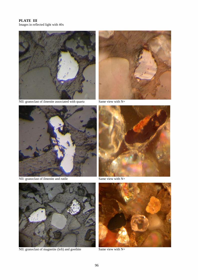
96
PLATE III Images in reflected light with 40x
NII: granoclast of ilmenite associated with quartz Same view with N+
NII: granoclast of ilmenite and rutile Same view with N+
NII: granoclast of magnetite (left) and goethite Same view with N+

Rom. J. Mineral Deposits, vol. 87 (2014), No. 2, p. 97-100
97
GEOCHEMISTRY OF TITANIUM HEAVY MINERALS IN STREAM SEDIMENTS FROM
THE BISTRIȚA AURIE RIVER (ROMANIA)
Cătălina CIORTESCU1, Gabriel O. IANCU
1, Ion SANDU
2, Viorica VASILACHE
2
1"Al. I. Cuza" University of Iaşi, Department of Geology, 20A Carol I Av., 700505 Iaşi, Romania;
2"Al. I. Cuza" University of Iaşi, ARHEOINVEST Interdisciplinary Platform Laboratory of Scientific Investigation
and Cultural Heritage Conservation, 22A Carol I Av., 700505 Iaşi, Romania;
Abstract: The present study focuses on the titanium heavy minerals sampled from alluvial sediments of the Bistrița
Aurie River, in order to determine the provenance and the potential economic value, using their geochemical
characteristics. A number of 8 selected samples have been collected and separated by gravity concentration in a gold
pan. The resulted alluvial concentrates were mounted in thin sections. Identification of the titanium minerals has
been carried out by using SEM-EDX analysis. Therefore, the mineral species founded in the alluvial concentrates
are: ilmenite (most abundant), rutile, leucoxene, titanite and titano-magnetite. The source of the ilmenite grains is
represented by the medium grade metamorphic rocks of Rebra and Bretila Metamorphic Units, while the source of
rutile grains is represented by the low-grade metamorphic rocks of the Tulgheș Metamorphic Unit. The average TiO2
content, greater than 50 wt. % for more than 90 % of the titanium minerals from the Bistrița Aurie River sediments,
increases the potential economic value of the Bistrița Aurie alluvial sediments.
Keywords: titanium minerals, Bistrița Aurie, alluvial sediments, provenance, potential economic
INTRODUCTION
The investigated river sediments derived from the exposed volcanic, metamorphic and
sedimentary rocks of the Bistrița Aurie hydrographic basin. In addition to the major constituents of the
alluvial sediments (quartz, feldspars, and lithic fragments), they contain small quantities of other mineral
grains, including heavy minerals (Joshua and Oyebanjo, 2009), defined as minerals having a higher
density than quartz, 2.65 g/cm3, or densities greater than 2.85 g/cm
3 (Elsner, 2010). The heavy minerals
from the river sediments have been studied for the determination of economic potential regarding the
presence of gems (Perera et al, 2013), gold and other strategic minerals such as zircon, ilmenite, rutile,
monazite etc. (Surour et al, 2003; Dill, 2008; Elsner, 2010). Another approach for the heavy minerals
research is the study of morphology (Moral Cardona et al., 2005; Dill, 2007) and grain size (Joshua and
Oyebanjo, 2010) but most of the investigations are related to petrogenetic and provenance studies.
The current research focused on the presence of titanium oxides as heavy minerals in alluvial
sediments of the Bistrița Aurie River. The chemistry of individual grains has been used in order to trace
and characterize the source rocks. Other issues discussed here, refer to the identification and composition
of titanium oxides in order to show their possible economic significance.
GEOLOGICAL FRAMEWORK
The Bistrița Aurie River springs from Rodna Mountains and ends on the confluence with Dorna
River. It has a length of about 70 km, 19 tributaries on the right side and 19 on the left side, and crosses
localities as Cârlibaba, Ciocănești, Iacobeni and Vatra Dornei (Donisă and Poghirc, 1968). The age of the
Bistrița valley is Pliocene-Quaternary (Donisă, 1968).
On the Bistrița Aurie drainage basin outcrops medium and low-grade metamorphic rocks
belonging to Crystalline-Mesozoic Zone (CMZ) of the Eastern Carpathians (Fig. 1). The CMZ belongs to
the eastern Getides found in the crystalline basement of the Transylvanian Basin. It consists of several
Alpine tectonic units with eastern vergency, sheared in Austrian tectogenesis (Albian) (Balintoni, 1997;
Hârtopanu, 2004). From top to bottom, these are: Bucovinian, Subbucovinian and Infrabucovinian nappes
(Săndulescu, 1984). Regarding the description of the metamorphic sequences in the CMZ, Bretila,
Tulgheş, Negrişoara, Rebra and Rodna Metamorphic Units are individualized (Balintoni, 2005).
Occasionally, Triassic conglomerates, sandstones, limestones, dolomites and lamprophyres veins that
penetrate the crystalline rocks appear (Podașcă, 2000; Săndulescu, 1984).
The Rebra Unit, a medium-grade sequence, is a typical continental margin sedimentary pile that
contains micaschists interbedded with limestones and amphibolites. The Bretila Unit is also a medium
grade sequence dominated by gneissic and amphibolitic rocks. Instead, the Tulgheş Metamorphic Unit is
a low-grade sequence (Dill et al., 2012).
ANALYTICAL METHODS
A number of 8 selected samples shown in Fig. 1 have been collected from the meanders, inside the
bend deposition, from the gravel bars and from the alluvial cones. After they were sieved through a 2 mm

98
mesh, the samples were separated by gravity concentration in a gold pan (according to Silva, 1986). This
procedure has been followed by removing the ferromagnetic fraction with a magnet bar. The alluvial
concentrates were mounted in Epidian epoxy resin, polished and coated with carbon. The identification of
the titanium oxides was done by using a VEGA II LSH SEM with EDX system type QUANTAX QX2
(analytical conditions: accelerating voltage 30 kV), from Interdisciplinary Platform Laboratory of
Scientific Investigation and Cultural Heritage Conservation - ARHEOINVEST, from the “Al. I. Cuza’’
University of Iași. Hence, the mineral classification is purely based on the chemical composition of the
measured grains. The distinction between ilmenite, leucoxene and rutile is based on the TiO2 wt. %
content only: 21 wt. % TiO2 < Ti-magnetite < 46 wt. % TiO2 < ilmenite < 70 wt. % TiO2 < leucoxene <
87.5 wt. % TiO2 < rutile (Keulen et al., 2012). Therefore, the TiO2 polymorphs (i.e., rutile, anatase and
brookite) cannot be distinguished in all the cases and are grouped as one mineral species.
RESULTS AND DISCUSSIONS
The principal sources of Ti, used on a large-scale in industry, are the following minerals: ilmenite,
leucoxene, and rutile (Keulen et al., 2012). One of the most essential parameter to the assessment of
quality and economics of a potential deposit is the determination of the TiO2 average content of the Ti
minerals (Elsner, 2010).
The titanium oxides have been described in all the analyzed samples both as individual grains and
as inclusions in others heavy minerals species. So, the titanium mineral species founded in the alluvial
concentrates are: rutile, ilmenite, leucoxene, titanite and titano-magnetite. Ilmenite is the most abundant
titanium mineral. About 40% of ilmenite crystals have a concentration very close or identical to the ideal
stochiometric value of 52.6 wt. % (Fig. 2).
When the concentration of TiO2 is more than 60 wt. % it will denote a continuous alteration of
primary ilmenite. This alteration via pseudorutile to leucoxene is attributed to complex processes of
oxidation and hydroxylation associated with leaching of Fe, leading to a significant increase in the TiO2
grade of the Ti mineral fraction (Grey and Reid, 1975; Keulen et al., 2012; Babu et al., 2013).
Also, a very sensitive proxy for the sediment maturity is the average TiO2 content of the ilmenite fraction
(Grey and Reid, 1975; Keulen et al., 2012).
In this study, the average TiO2 content, greater than 50 wt. % for more than 90 % of the Ti
minerals from the Bistrița Aurie River sediments (Fig. 2), as one of the most essential parameter to the
assessment of quality and economics of a potential deposit, indicate progressive leaching of Fe from
primary ilmenite specifically to mature sediments. This fact increases the potential economic value of the
Bistrița Aurie alluvial sediments.
By studying only the TiO2 content is very hard to define the source of the detrital ilmenite.
Nevertheless, titanium minerals occur in all the samples together with garnets (Almandine 80-100 %).
Ilmenite is described very often as inclusion in garnet (Fig. 3A) or staurolite (Fig. 3B), together with
quartz, apatite and zircon. Thus, its source can be attributed to the medium-grade metamorphic rocks
belonging to Rebra and Bretila Metamorphic Units.
The rutile crystals that occur in alluvial concentrates show very often a sagenitic structure that
forms a network of equilateral triangles or rhomboids. Marginal rutile crystals are smaller and less
frequent (Fig. 3C). The remaining free space is occupied by hematite (Fig. 3C, D) and chlorite after
biotite. Such aggregates are described by Balintoni and Chițimuș (1973) as a rutile paramorph after
brookite, in the Tulgheș Metamorphic Unit. These paramorphs are attributed to the initial metamorphosis
of Tulgheș unit, and the transformation of biotite to chlorite is hercynian and corresponds to last
retrograde metamorphic event (Balintoni and Chițimuș 1973). The titano-magnetite occurs very rare in
the alluvial concentrates because of the pretreatment related by removal of ferromagnetic fraction. The
titanite occurs only as inclusions in garnet.
CONCLUSIONS
The titanium mineral species found in the alluvial concentrates are: ilmenite (the most abundant),
rutile, leucoxene, titanite and titano-magnetite. The average TiO2 content, greater than 50 wt. % for more
than 90 % of the Ti minerals from the Bistrița Aurie River sediments is specific to mature sediments. This
fact increases the potential economic value of the analyzed alluvial sediments. The ilmenite grains
originated most probably in the medium grade metamorphic rocks belonging to Rebra and Bretila
Metamorphic Units.
On the other hand, the source of rutile grains is the low grade metamorphic rocks of the Tulgheș
Metamorphic Unit.

99
Fig. 1 Geological Map of the Bistrița River drainage basin (modified after Krautner and Bindea, 2000; scale
1:200000), showing the sample location.
Fig. 2 Average TiO2 content of the Ti mineral
fraction in Bistrița Aurie River sediments.
Fig. 3. A - BSE image of a detrital garnet with ilmenite and quartz inclusions; B - BSE image of a detrital staurolite
with ilmenite inclusions (inclusions of poikilitic quartz can be seen); C - BSE image of a rutile with sagenitic
structure; D - BSE image of a rutile detrital mineral.
100
REFERENCES
Babu, N., Babu, S. and Suresh Babu, D. S., 2013. Heavy Mineral Distribution and Characterisation of
Ilmenite of Kayamkulam - Thothapally Barrier Island, Southwest Coast of India. Journal
Geological Society of India. 81, 129-140.
Balintoni, I., 1997. The geotectonics of the Romania’s metamorphic terrain. Carpatica Publishing House,
Cluj Napoca. 176.
Balintoni, I., 2005. Geotectonic Dividing of the Romanian territory for the Alpine orogenesis. Journal of
the Science Policy and Scientometrics, Special no. ISSN- 1582-1218.
Balintoni, I. and Chiţimuș, V., 1973. Rutile paramorphosis presence after brookite in Tulgheș series
(Eastern Carpathians). Studies and Research in Geology, Geophysics and Geography, Geology
Series, 18 (2): 329–334 (in Romanian with English abstract).
Dill, H.G., 2007. Grain morphology of heavy minerals from marine and continental placer deposits, with
special reference to Fe–Ti oxides. Sedimentary Geology 198, 1-2, 1–27.
Dill, H.G., 2008.Geogene and anthropogenic controls on the mineralogy and geochemistry of modern
alluvial–(fluvial) gold placer deposits in man-made landscapes in France, Switzerland and
Germany. Journal of Geochemical Exploration 99, 1-3, 29–60.
Dill, H.G., Iancu, O.G., Ionesi V., Sârbu, S., Balintoni, I. and Botz, R., 2012. Petrography and mineral
chemistry of Bessarabian siliciclastic rocks in the Eastern Carpathians Foreland Basin (Romania
and Republic of Moldova). N. Jb. Geol. Paläont. Abh. 263/3, 199–226.
Donisă, I., 1968. Geomorphology Bistrița Valley. Romanian Academy Press. Bucureşti.
Donisă, I. and Poghirc P., 1968. Bistrița Valley. The Scientific Press, București, 212.
Elsner, H., 2010. Heavy minerals of economic importance. Assessment manual. Bundesanstalt für
Geowissenschaften und Rohstoffe (BGR) (Federal Institute for Geosciences and Natural
Resources), 218.
Grey, I.E. and Reid, A.F., 1975. The structure of pseudorutile and its role in the natural alteration of
ilmenite. Amer. Mineral. 60, 898-906.
Hîrtopanu, P., 2004. Mineral genesis of the manganese belt from Bistrița Mountains . Academic Book
Publishing House, Bucureşti, 352.
Joshua, E.O., Oyebanjo O.A., Jibiri N.N. and Fasunwon O.O., 2010. Osun River Basin Sediments Heavy
Mineral Distribution. The Pacific Journal of Science and Technology, 11, 1-3, 598-605.
Keulen, N., Frei, D. and Riisager, P., 2012. Analysis of Heavy Minerals in Sediments by Computer-
controlled Scanning Electron Microscopy (Ccsem): Principles and applications. Mineralogical
Association of Canada, Short Course 42, St. John’s NL, 167-184.
Krautner, H.G. and Bindea, G., 2000. Alpine and Prealpine Structural and Lithological Units
Moral Cardona, J.P., Gutierrez Mas, J.M., Sanchez Bellon, A., Dominguez-Bella, S. and Martinez Lopez,
J., 2005. Surface textures of heavy-mineral grains: a new contribution to provenance studies.
Sedimentary Geology 174, 3-4, 223–235.
Perera, S. H. K., Jayasinghe, R. M. N. P. K., Dharmaratne, T. S. and Cooray, J. T., 2013. An Assessment
of Economic Heavy Minerals Associated with Gem-bearing Gravel Layers in Kiriella Division.
Technical Sessions of Geological Society of Sri Lanka, 29, 69-73.
Podașcă, I., 2000. Structural, lithostratigraphical and petrological study of the crystalline rock’s
formations from the Bistrița River Basin between Cârlibaba and Iacobeni (Eastern Carpathians).
PhD thesis , Al. I. Cuza University of Iași, 140.
Săndulescu, M., 1984. Romania’s Geotectonics. Ed. Tehn., Bucuresti, 336.
Silva, M., 1986. Placer gold recovery methods. Division of Mines and Geology, California Department of
Conservation, Special Publication 87, 31.
Surour, A.A. , El-Kammar, A.A., Arafa, E.H. and Korany, H.M., 2003. Dahab stream sediments,
southeastern Sinai, Egypt: a potential source of gold, magnetite and zircon. Journal of Geochemical
Exploration 77, 1-2, 25–43.

Rom. J. Mineral Deposits, vol. 87 (2014), No. 2, p. 101-104
101
PRELIMINARY DATA ON THE GEOCHEMISTRY OF THE STRĂJII VALLEY TAILING
POND (SUCEAVA COUNTY, ROMANIA)
Marian Marius CHICOȘ1,*, Gheorghe DAMIAN
1,2, Dan STUMBEA
1
1 “Alexandru Ioan Cuza” University of Iaşi, Faculty of Geography and Geology, Department of Geology, 20A Carol
I Blv., 700505 Iaşi, Romania, *e-mail: [email protected]. 2 Technical University Cluj-Napoca, North University Center Baia Mare, 62, Victor Babes Str., 433003 Baia Mare,
Romania.
Abstract. Specific characteristics and some mineralogical and geochemical aspects of the mine tailings derived
from the ore processing plant of Tarnița represent a potential risk for the environment. The material of the tailing
pond mostly has a greyish color, rarely a yellow-ochre one, and consists mainly of fine and very fine sand, silt and
clay fractions (more than 75%). In terms of the mineralogy, the primary minerals have been identified as quartz,
sericite, chlorite, pyrite, subordinate sphalerite, galena and accidentally barite; secondary minerals (probably
sulfates) have been recognized as well. The rate of soluble fraction has a relative wide range, from 3.78 to 34.71%,
the average abundance being of 11.15%; the values of leaching solution pH are extremely low (from 2.46 to 2.89),
with an average of 2.67. Chemical analysis showed that the concentrations are very high for both toxic elements
(Pb>As>Cr>Co) and major elements (Fe>Al>Mg>Mn). In this occurrence the relationships between the elements,
as well as that of the elements with the soluble fraction, showed some significant correlations, as follow: soluble
fraction with Mg > Al > As > Pb > Mn; Al with Mg > Mn; Mg with Pb > As; Pb with As; Fe only with Co. Cr
displays no correlation.
Keywords: mine tailing, mineralogy, geochemistry, XRF, acid mine drainage, toxic metals.
1. Introduction
The present preliminary study focuses on the description of the mine tailings resulted from the ore
processing plant of Tarnița. The Tarnița ore processing plant operated from the 1950s to 2007, and had
two units of extraction (through flotation processes): the extraction of Cu from the Cu-rich pyrite and the
unit aimed to benefit barite extraction; both of them produced large amounts of waste material, deposited
on large areas near the processing plant.
The tailing pond under study is located nearby the Puzdra county road 177A (Holda - Frasin) on the
territory of Ostra village, at about 6 km SW from its center; more exactly, the waste deposit is on the
Valea Străjii valley, at a distance of about 800 m from the Suha River. It has an elongate shape (as a
cone), with a length of roughly 500 m; the maximum width is of 250 m at its northwestern sector, were an
unconsolidated damp is built (Fig. 1). In the SE part of the tailing pond (in the peak of the cone), a pool of
water was accumulated. The material of the tailing pond generally has a greyish color, but in some places
it displays a yellow-ochre tint; it contains non-aggregated minerals, in other words it has a sandy
appearance.
Fig. 1. The location of the tailing pond from Străjii Valley.
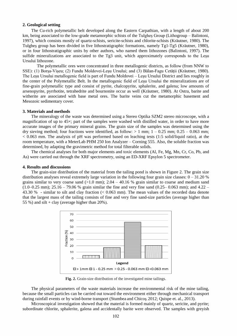
102
2. Geological setting
The Cu-rich polymetallic belt developed along the Eastern Carpathian, with a length of about 200
km, being associated to the low-grade metamorphic schists of the Tulgheș Group (Lithogroup – Balintoni,
1997), which consists mostly of quartz-schists, sericite-schists and chlorite-schists (Kräutner, 1980). The
Tulgheș group has been divided in five lithostratigraphic formations, namely Tg1-Tg5 (Kräutner, 1980),
or in four lithostratigraphic units by other authors, who named them lithozones (Balintoni, 1997). The
sulfide mineralizations are associated to the Tg3 unit, which approximately corresponds to the Leșu
Ursului lithozone. The polymetallic ores were concentrated in three metallogenic districts, as follow (from NNW to
SSE): (1) Borșa-Vișeu; (2) Fundu Moldovei-Leșu Ursului; and (3) Bălan-Fagu Cetății (Kräutner, 1980).
The Leșu Ursului metallogenic field is part of Fundu Moldovei – Leșu Ursului District and lies roughly in
the center of the Polymetallic Belt. In the metallogenic field of Leșu Ursului the mineralizations are of
fine-grain polymetallic type and consist of pyrite, chalcopyrite, sphalerite, and galena; low amounts of
arsenopyrite, pyrrhotite, tetrahedrite and bournonite occur as well (Kräutner, 1980). At Ostra, barite and
witherite are associated with base metal ores. The barite veins cut the metamorphic basement and
Mesozoic sedimentary cover.
3. Materials and methods
The mineralogy of the waste was determined using a Stereo Optika SZM2 stereo microscope, with a
magnification of up to 45×; part of the samples were washed with distilled water, in order to have more
accurate images of the primary mineral grains. The grain size of the samples was determined using the
dry sieving method; four fractions were identified, as follow: > 1 mm; 1 – 0.25 mm; 0.25 – 0.063 mm;
< 0.063 mm. The analysis of pH was performed based on leaching tests (1:5 solid/liquid ratio), at the
room temperature, with a MeterLab PHM 250 Ion Analyzer – Corning 555. Also, the soluble fraction was
determined, by adapting the gravimetric method for total filterable solids.
The chemical analyses for both major elements and toxic elements (Al, Fe, Mg, Mn, Cr, Co, Pb, and
As) were carried out through the XRF spectrometry, using an ED-XRF Epsylon 5 spectrometer.
4. Results and discussions
The grain-size distribution of the material from the tailing pond is shown in Figure 2. The grain size
distribution analyses reveal extremely large variation in the following four grain size classes: 0 – 31.20 %
grains similar to very coarse sand (>1.0 mm); 2.04 – 40.16 % grain similar to coarse and medium sand
(1.0–0.25 mm); 25.16 – 79.06 % grain similar the fine and very fine sand (0.25– 0.063 mm); and 4.22 –
43.30 % - similar to silt and clay fraction (< 0.063 mm). The mean values of the recorded data denote
that the largest mass of the tailing consists of fine and very fine sand-size particles (average higher than
55 %) and silt + clay (average higher than 20%).
Fig. 2. Grain-size distribution of the investigated mine tailings.
The physical parameters of the waste materials increase the environmental risk of the mine tailing,
because the small particles can be carried out toward the environment either through mechanical transport
during rainfall events or by wind-borne transport (Stumbea and Chicoș, 2012; Quispe et. al., 2013).
Microscopical investigation showed that the material is formed mainly of quartz, sericite, and pyrite;
subordinate chlorite, sphalerite, galena and accidentally barite were observed. The samples with greyish

103
color are more abundant in galena; the next most-abundant mineral is quartz, then sericite. In terms of the
yellow-ochre samples, quartz is more abundant and it is highly limonitized. Also, the presence of some
aggregates on the surface of the primary minerals (e.g. quartz, pyrite) has been noticed. According to
previous researches, these aggregates consist of hydrated sulfates of Al, Fe, Mg, Mn and incorporate toxic
elements in their structures (Moncur et al., 2005; Hammarstrom, et. al., 2005). This is in agreement with
Stumbea’s results (unpublished data) that identified within the waste of an another tailings pond from the
same perimeter, the presence of jarosite, alunogen, copiapite, and coquimbite. The sulfates developed
within the waste material of the mine tailing are generally very soluble and they are an important factor
that generate acidity and high concentrations in toxic elements, SO4 and Fe (Blowes et al., 2005; Carbone
et. al., 2013).
In this preliminary paper, the abundance of the soluble fraction from the mine tailings was also
determined. The soluble fraction ranges within a relative wide interval, from 3.78 to 34.71 %, with an
average of 11.15%. Regarding the acidity of the material from the tailing pond, the analyses showed a
very low pH (< 3), with a range between 2.46 and 2.89, and an average of 2.67.
The statistical summary of the chemical composition of the tailing samples, in terms of major
elements (Al, Fe, Mg and Mn) and toxic elements (Cr, Co, Pb and As), is presented in Table 1, where
minimum, maximum and average data are indicated for each element.
Table 1. The statistical summary of the amount of primary elements (Al, Fe, Mg, and Mn) and toxic elements (Cr,
Co, Pb and As) (n= 23)
Al
(wt %)
Fe
(wt %)
Mg
(wt %)
Mn
(wt %)
Cr
(ppm)
Co
(ppm)
Pb
(ppm)
As
(ppm)
Minimum 3.27 9.44 0.05 0.01 11.00 24.80 219.00 64.50
Maximum 16.71 18.43 3.15 0.02 92.00 52.80 4073.00 326.40
Average 8.41 12.46 1.27 0.02 35.91 32.50 1412.78 139.00
Concerning the concentrations presented in the Table 1, a wide ranges of data can be observed.
Moreover, the average values for all samples exhibit very high concentrations of toxic elements (Pb, As,
Cr, and Co) and some major elements (Al, Fe and Mg), except for Mn which shows a roughly low
amount. The highest concentration among the determined toxic elements is shown by Pb (an average of
1413 ppm) and As (an average of 139 ppm). The waste material of the mine tailing is a source of
contaminants with high concentrations in toxic elements, high acidity and probably SO4 and Fe from the
very soluble sulfates. The chemical analyses show the following concentration ratios, in a decreasing
order of abundance: Pb>As>Cr>Co (toxic elements) and Fe>Al>Mg>Mn (major elements).
In order to establish the relationships between the elements considered in this study, a Pearson
correlation matrix has been calculated (Table 2). Thereby, Pb and As have a positive correlation with
some major elements (Al, Mn, Mg). In addition, the above mentioned toxic elements – on one hand, and
the major elements – on the other, revealed correlations between them. Moreover, all these elements show
correlations with the soluble fraction. Fe concentration only correlates with Co, and both display no
correlation with the soluble fraction. However, it is important to note that some of them (e.g., Cr) displays
no correlation with either other elements or soluble fraction.
Table 2. Pearson's correlation matrix between soluble fraction, primary elements and toxic elements (n = 23)
S.F. = soluble fraction; values with correlation are in bold.
Variables Al Fe Mg Mn Cr Co Pb As S.F.
Al 1
Fe -0.263 1
Mg 0.903 -0.252 1
Mn 0.494 -0.236 0.378 1
Cr -0.223 -0.206 -0.147 0.348 1
Co -0.380 0.975 -0.399 -0.310 -0.204 1
Pb 0.660 -0.005 0.704 0.390 -0.158 -0.149 1
As 0.611 0.168 0.639 0.392 -0.190 0.045 0.938 1
S.F. 0.767 -0.020 0.789 0.555 -0.173 -0.169 0.649 0.681 1

104
These findings, associated with those mentioned above (the identified mineral aggregates, high
abundance of soluble fraction, high acidity, high concentrations in toxic elements and major elements),
lead to the assumption that the studied materials contains sulfates as well. This assumption needs to be
proved by further studies based on X-ray diffractometry.
5. Conclusions
This study presents some geochemical aspects regarding the materials of the tailing pond from the
Străjii Valley, resulted from the flotation plant of Tarnița. In terms of mineralogy, the identified sulfide
minerals are pyrite and subordinate sphalerite and galena. Gangue is not very variable, being mainly
composed of quartz and sericite; accidentally, chlorite and barite were observed as well. The largest mass
of the tailing consists of fine and very fine sand-size particles; the silt and clay fractions are also well
represented. The amount of the soluble fraction ranges within a relative wide interval (3.78-34.71%) and
the leaching solutions exhibit a very low pH (2.46 - 2.89). The concentrations in major and toxic elements
are very high. Thus, Fe and Al have a very high concentration with means of 12.46% and 8.41%,
respectively. A relatively high concentration is shown by Mg (mean of 1.23 %), while Mn has a roughly
low concentration, with a mean of 0.02%. In terms of the mean amount of the toxic elements, the
following sequence of abundance has been identified: Pb (1413 ppm) > As (139 ppm) > Cr (36 ppm) >
Co (32 ppm). A part of the elements are highly correlated between them or with the amount of soluble
fraction, a fact that might be explained by the presence of the sulfates within the waste material. This
study underlined once again the potential risk of the mine tailing for the environment.
Acknowledgements
The authors of the present paper express their gratitude to associate professor Nicolae Buzgar
(Department of Geology, University “Alexandru Ioan Cuza” of Iași) for the XRF analyses.
References:
Balintoni, I., 1997. Geotectonics of the metamorphic terranes from Romania (In Romanian). Editura
Carpatica, Cluj-Napoca, 178p.
Blowes, D.W., Ptacek, C.J., Jambor, J.L., Weisner, C.G., 2005. The geochemistry of acid mine drainage.
In:Lollar, B.S., (Ed.) Environmental Geochemistry.Vol. 9, Holland, H.D., 23
Carbone, C., Dinelli, E., Marescotti, P., Gasparotto, G., Lucchetti, G., 2013. The role of AMD secondary
minerals in controlling environmental pollution: Indications from bulk leaching tests. Journal of
Geochemical Exploration. 132, 188–200.
Hammarstroma, J.M., Seal II, R.R., Meierb, A.L., Kornfeldc, J.M., 2005. Secondary sulfate minerals
associated with acid drainage in the eastern US: recycling of metals and acidity in surficial
environments. Chemical Geology. 215, 407– 431.
Kräutner, H. G., 1980. Litostratigraphic correlation of Precambrian of the Romanian Carpathians.
Anuarul Institutului de Geologie și Geofizică, București. 57, 229-296.
Moncur, M.C., Ptacek, C.J., Blowes, D.W., Jambor, J.L., 2005. Release, transport and attenuation of
metals from an old tailings impoundment. Applied Geochemistry, 20, 639-659.
Quispe, D., Pérez-López, R., Acero, P., Ayora, C., Nieto, J.M., 2013. The role of mineralogy on element
mobility in two sulfide mine tailings from the Iberian Pyrite Belt (SW Spain). Chemical Geology.
345, 119-129.
Stumbea, D., and Chicoș, M., 2012. Preliminary data regarding the tailing pond of Suha Valley – Tarnița,
Suceava County (Romania). Analele Ştiinţifice ale Universităţii " Alexandru Ioan Cuza” Iaşi, Seria
Geologie. 58, 1, 23–33.

Rom. J. Mineral Deposits, vol. 87 (2014), No. 2, p. 105-108
105
DETERMINATION OF PHOSPHOGYPSUM FROM ROMANIA BY SEM-EDAX
Aurora Măruţa IANCU1*
, Delia Georgeta DUMITRAŞ1, Ştefan MARINCEA
1,
Essaid BILAL2, Cristina GHINEŢ
1, Maria Angela ANASON
1
1Geological Institute of Romania, 1 Caransebeş St 012271, Bucharest, Romania,
2Ecole Nationale Supérieure des Mines de Saint Etienne, UMR6425, CNRS, France
Abstract:
Phosphogypsum is a technogenic product remaining after the extraction of phosphoric acid from raw phosphate,
mainly apatite. The phosphate rock mainly composed of apatite, and originating from Morocco, Russia, Syria,
Jordan and India, is treated with concentrated sulfuric acid (96%), after fine crushing to supra colloidal size and
passing into an aqueous solution of phosphoric acid.
The morphology of crystals is influenced by the conditions of phosphoric acid manufacture. Most of the analyzed
crystalline phases, especially gypsum, have micronic size, are very water absorbing and are detectable only at the
level of crystalline individual through the scanning electron microscopy.
Keywords: deposits, phosphogypsum, SEM, phosphates, EDAX
1) Introduction:
Phosphogypsum from three deposits in Romania, i.e. Turnu Măgurele, Năvodari and Bacău,
made the object of our study. The total area of these deposits is of 182.5 ha, and the total quantity of
phosphogypsum is 18.106 t. The phosphogypsum was formed as a result of environmental factors. A
macroscopic study of the phosphogypsum was carried out, revealing a powdery or sandy appearance. At
the surface it has a relatively harsh crust. The color is white-yellow or ginger. The presence of brushite,
as a second phases of phosphogypsum was mentioned by Caravețeanu (2013).
Direct observations on the samples, argued that phosphogypsum from the three deposits are very
similar at first sight. However, at this point, we observed some minor differences.
Four morphological types can be separated according to their appearance (Fig.1):
1) phosphogypsum with sandy appearance and yellow color (Fig. 1.A);
2) phosphogypsum as crusts (Fig. 1.B - some granules of white color can be noticed within it);
3) phosphogypsum with powdery appearance and yellow color (Fig. 1.C);
4) nacreous and white phosphogypsum (Fig. 1.D - the broken pieces in the picture were collected for
analyses).
The minerals present micronic size and the crystals are detectable only by scanning electron
microscopy.
2) Methods:
10 samples of phosphogypsum from Năvodari, 10 samples of phosphogypsum from Turnu
Măgurele and 5 samples of the Bacău phosphogypsum have been analyzed by using the scanning electron
microscopy. The samples were coated with QUARUM Q150 R ES, or gold.
The scanning electron microscopy was performed with a ,,JEOL JSM 6400 SCANNING
MICROSCOPE’’. The accelerating voltage was 15KV.
The semi-quantitative determination of the composition was determined by using EDAX method
on the points marked on the SEM images in Fig. 2.
3) Results:
As it can be seen in Fig. 2.A, B and C, the phosphogypsum predominates in the samples.
This composition (At%) is presented in Table 1. The data obtained from EDAX analyses have
been plotted in ternary diagrams (Fig. 3). From Table 1 and Fig. 3, it can be noticed that SO4
predominates and PO4 is in small quantities in the analysed samples.

106
A B
C D
Fig.1. Representatives images of Romanian phosphogypsum from Turnu Măgurele (A and D),
Năvodari (B), and Bacău (C).
A B
C
Fig.2. Scanning electron microscopy images of three
samples of phosphogypsum from Turnu Măgurele,
Năvodari and Bacău on which chemical analyses were
performed, too.
A. Turnu Măgurele sample, with 3 points of chemical
analyses (red arrows). B. Năvodari sample, with 2
points of chemical analyses (red arrows). C. Bacău
sample, with one chemical analysis (red arrow).

107
Table 1. The data obtained from EDAX analyses for the phosphogypsum samples from Romania.
Turnu Măgurele At% Năvodari At% Bacău At%
(SO4)2- Ca (PO4)
3- (SO4)2- Ca (PO4)
3- (SO4)2- Ca (PO4)
3-
1 39.40 58.36 1.50 1 39.40 58.36 1.50 1 53.62 42.34 2.07
2 52.19 46.91 0.91 2 52.19 46.91 0.91 2 39.55 56.62 3.10
3 33.97 62.77 2.55 3 33.97 62.77 2.55 3 25.88 72.00 1.09
4 45.90 51.93 1.87 4 45.90 51.93 1.87 4 51.88 46.88 1.21
5 24.74 66.20 7.21 5 24.74 66.20 7.21 5 51.76 47.46 0.77
6 0.38 1.07 0.11 6 0.38 1.07 0.11 - - - -
7 0.38 1.07 0.11 7 0.38 1.07 0.11 - - - -
8 40.72 57.35 1.84 8 40.72 57.35 1.84 - - - -
9 49.03 48.71 1.94 9 49.03 48.71 1.94 - - - -
10 49.61 48.33 1.75 10 49.61 48.33 1.75 - - - -
11 51.33 46.67 1.71 11 51.33 46.67 1.71 - - - -
12 52.10 46.32 1.46 12 52.10 46.32 1.46 - - - -
13 46.65 52.51 0.84 13 46.65 52.51 0.84 - - - -
14 47.64 48.63 3.37 14 47.64 48.63 3.37 - - - -
15 52.63 45.33 1.64 15 52.63 45.33 1.64 - - - -
16 53.21 46.68 1.91 16 53.21 46.68 1.91 - - - -
17 46.81 51.19 1.48 17 46.81 51.19 1.48 - - - -
18 2.02 51.18 43.79 18 2.02 51.18 43.79 - - - -
19 53.22 43.75 2.59 - - - - - - - -
20 54.14 43.78 1.75 - - - - - - - -
21 51.62 46.01 2.15 - - - - - - - -
22 54.75 42.98 2.17 - - - - - - - -
23 53.10 43.92 2.03 - - - - - - - -
24 53.94 44.20 1.72 - - - - - - - -
25 54.46 43.27 2.15 - - - - - - - -
26 54.61 43.14 1.93 - - - - - - - -
27 52.70 43.91 2.40 - - - - - - - -
28 54.42 45.00 0.58 - - - - - - - -
29 48.91 50.06 1.02 - - - - - - - -
30 54.24 42.74 2.37 - - - - - - - -
31 53.89 44.64 1.39 - - - - - - - -
32 54.29 41.65 3.54 - - - - - - - -
33 35.15 63.61 1.24 - - - - - - - -
34 53.81 41.42 4.00 - - - - - - - -
35 54.27 41.67 3.41 - - - - - - - -
36 54.11 42.60 3.17 - - - - - - - -
37 42.48 56.22 1.30 - - - - - - - -
38 52.62 41.72 4.05 - - - - - - - -
39 52.42 37.75 3.20 - - - - - - - -
40 55.25 40.21 3.54 - - - - - - - -
41 55.07 42.39 2.47 - - - - - - - -
42 54.86 42.61 2.41 - - - - - - - -
43 54.29 43.15 1.84 - - - - - - - -
44 52.42 44.95 2.63 - - - - - - - -
45 54.11 42.62 2.64 - - - - - - - -
46 53.59 43.57 2.46 - - - - - - - -
47 53.96 41.44 3.91 - - - - - - - -
48 52.78 44.42 2.80 - - - - - - - -
4) Discussion
The gypsum crystals are prismatic to acicular, showing perfect cleavage after [001]. Individual
crystals have lengths ranging from 10 to 120 μm. The phosphogypsum crystals of the second
morphological type are grouped in polycrystalline, weakly cohesive aggregates. A morphological feature
of this type consists of the homogeneous crystal size. Crystal morphology of this group is relatively large
and tends to form aggregates of accretion, with randomly oriented and interlocking crystals. The crystal
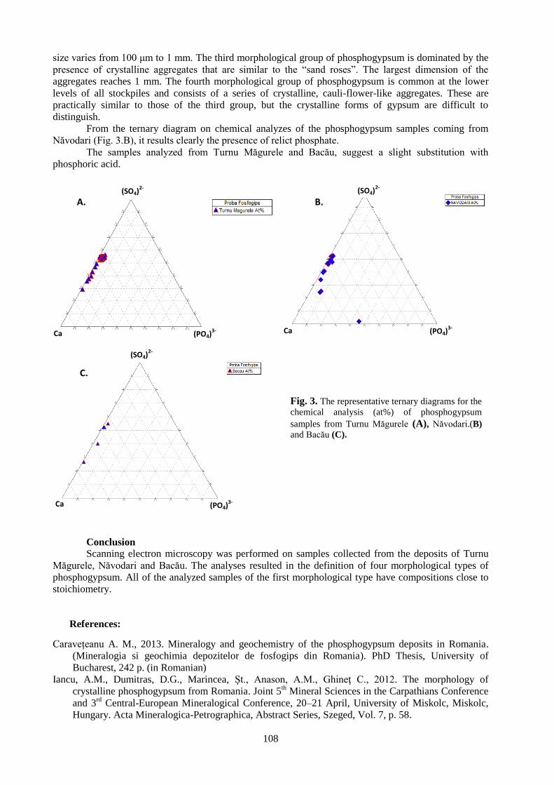
108
size varies from 100 μm to 1 mm. The third morphological group of phosphogypsum is dominated by the
presence of crystalline aggregates that are similar to the “sand roses”. The largest dimension of the
aggregates reaches 1 mm. The fourth morphological group of phosphogypsum is common at the lower
levels of all stockpiles and consists of a series of crystalline, cauli-flower-like aggregates. These are
practically similar to those of the third group, but the crystalline forms of gypsum are difficult to
distinguish.
From the ternary diagram on chemical analyzes of the phosphogypsum samples coming from
Năvodari (Fig. 3.B), it results clearly the presence of relict phosphate.
The samples analyzed from Turnu Măgurele and Bacău, suggest a slight substitution with
phosphoric acid.
Fig. 3. The representative ternary diagrams for the
chemical analysis (at%) of phosphogypsum
samples from Turnu Măgurele (A), Năvodari.(B)
and Bacău (C).
Conclusion Scanning electron microscopy was performed on samples collected from the deposits of Turnu
Măgurele, Năvodari and Bacău. The analyses resulted in the definition of four morphological types of
phosphogypsum. All of the analyzed samples of the first morphological type have compositions close to
stoichiometry.
References:
Caravețeanu A. M., 2013. Mineralogy and geochemistry of the phosphogypsum deposits in Romania.
(Mineralogia si geochimia depozitelor de fosfogips din Romania). PhD Thesis, University of
Bucharest, 242 p. (in Romanian)
Iancu, A.M., Dumitras, D.G., Marincea, Şt., Anason, A.M., Ghineţ C., 2012. The morphology of
crystalline phosphogypsum from Romania. Joint 5th Mineral Sciences in the Carpathians Conference
and 3rd
Central-European Mineralogical Conference, 20–21 April, University of Miskolc, Miskolc,
Hungary. Acta Mineralogica-Petrographica, Abstract Series, Szeged, Vol. 7, p. 58.
A. B.
C.
(SO4)2-
(SO4)2-
(SO4)2-
Ca
Ca Ca (PO4)3-
(PO4)3-
(PO4)3-


- continued from the front cover -
Adolf Heinrich HORN, Hernando BAGGIO, Rafaelle SCHIMITH
Selected element distribution in bottom sediment samples from Três Marias Lake
and its significance, Minas Gerais, Brazil .............................................................................................................. 39
Adolf Heinrich HORN, Igo Fernando LEPSCH, Regynaldo Arruda SAMPAIO, Márcio
Neves RODRIGUES, Anarelly Costa ALVARENGA, Ely Sandra Alves de OLIVEIRA
Heavy metals and aluminum content inside silicophytoliths from Ricinus communis,
Andropogon arundinaceus and Brachiaria decumbens grown on soils added with
sewage sludge and heavy metal salts (Brazil) …………………………………………………………………… 43
Hernando BAGGIO, Heinrich HORN, Thiago MARTINS, Matheus SIMÕES
Rainfalls and natural disasters: the 2011 - 2012 events in Minas Gerais State - Brazil …………………………. 47
Najla LASSOUED, Mohamed Naceur KHELIL, Saloua REJEB, Essaid BILAL,
Mohamed CHAOUACHI, Mohamed Néjib REJEB
Incidence of sewage sludge fertilizer application on Ray Grass (Morocco) ……..……………………………… 51
Fernando Machado de MELLO, Rômulo MACHADO, Essaid BILAL
Predisposing factors for shallow landslides susceptibility in southeastern Rio de Janeiro, Brazil ……………… 55
Márcia Andréia da SILVA NUNES, Adolf Heinrich HORN, William Fortes RODRIGUÊS,
Essaid BILAL
Environmental conditions on the eastern part of the Caparaó Range National Parc and its sourroundings,
Espírito Santo State, Brazil ……………………………………………………………………………………… 61
Ahmed TOUIL, Mohamed HIBTI, Essaid BILAL, Abdessamad EL KHALILE
Chemistry of minerals from the Azegour skarn deposits, western High Atlas, Morocco ……………………….. 67
Alexandre Sylvio Vieira DA COSTA, Adolf Heinrich HORN
The use of dimension stone cut residual in agriculture soil correction. An example from
Espirito Santo State, Brazil …………………………………………………………………….……................... 71
Alexandre Sylvio Vieira DA COSTA, Adolf Heinrich HORN, Amando de Pinho AGUIAR
Changes in the P-concentration in brazilian soils after aplication of waste material
from dimension stone production, Brazil …………………………………………………………..…………… 75
Alexandre Sylvio Vieira DA COSTA, Adolf Heinrich HORN, Amando de Pinho AGUIAR
Uso reaction products of battery acid from cars and cellulose waste from industry as a
new fertilizer for corn cultivation (Zea mays l.) on poor soils, on an example from
Governador Valadares in Minas Gerais, Brazil ..................................................................................................... 79
Ines GALFATI, Essaid BILAL, Hassan ABDALLAH, Aicha BEJI SASSI
Geochemistry of solid effluents and phosphate ore washed from Métlaoui-Gafsa Basin, Tunisia ....................... 83
Denisa JIANU, Răzvan ORZA, Cezar IACOB, Lucian PETRESCU, Virgil IORDACHE, Aurora
NEAGOE, Julieta RUSU
The potential hazard induced by heavy metal contamination related to tailings ponds. Case study:
Pîrâul Cailor tailing pond (Suceava County, Romania) …………......................................................................... 87
Iulia NEGREA, Daniela DIMOFTE, Gheorghe C. POPESCU
Preliminary data regarding sands heavy minerals from the Levee Letea (Danube Delta) …................................. 91
Cătălina CIORTESCU, Gabriel O. IANCU, Ion SANDU, Viorica VASILACHE
Geochemistry of titanium heavy minerals in stream sediments from the Bistrița Aurie River (Romania) ……… 97
Marian Marius CHICOȘ, Gheorghe DAMIAN, Dan STUMBEA
Preliminary data on the geochemistry of the Străjii Valley tailing pond (Suceava County, Romania) ………….. 101
Aurora Măruţa IANCU, Delia Georgeta DUMITRAŞ, Ştefan MARINCEA, Essaid BILAL,
Cristina GHINEŢ, Maria Angela ANASON
Determination of phosphogypsum from Romania by SEM-EDAX ……………………………………………… 105