route guide le - bak · route guide colorado to elkhart elkhart to satanta satanta to spearville...
TRANSCRIPT

Route Guide
Colorado to Elkhart
Elkhart to Satanta
Satanta to Spearville
Spearville to Ellinwood
Ellinwood to Salina
Salina to Wamego
Wamego to Oskaloosa
Oskaloosa to Hiawatha
Hiawatha to Highland4
5
6
7
8
9
3
2
mobile
1

2Elkhart
Satanta
Spearville
Ellinwood
Salina
Wamego Oskaloosa
HiawathaHighland
Hugoton
Larned
Ellsworth
Manhattan
Silver Lake
Horton
Dodge City
White Cloud
18 62
78
80
72
88
66
56
35
View a Google Map of the BAK 2014 Route at: www.bak.org/maps
Biking Across Kansas will post mobile updates and notices during the week of June 7–14.
Facebook: www.facebook.com/bikingkansasTwitter: @2014_bak

3
Biking Across Kansas promotes health and
wellness through bicycling, the history and
beauty of the Kansas landscape, and the warm
hospitality of the Kansas towns and people.
Biking Across Kansas, Inc. in no manner
warrants the safety of the routes to be used
on BAK 2014. All roads suggested are regular
roads of the highway system, used by auto-
mobiles, trucks and other vehicles, with no
special lanes for bicycles.
As no separate lanes are provided for bicycles,
the bicyclist assumes the risk for his/her own
safety when using the routes indicated for use
on BAK 2014.
To report an accident or emergency on the
road, FIRST call 911 and then notify BAK staff
with the BAK Emergency number:
(913) 735-3035
Route Guide
All maps copyright © 2014 Biking Across Kansas. Selected history notes in this guide are from the Kansas Guidebook by Marci Penner. History research by Molly Mabie.

4
Biking Across Kansas 2014
4
Safety & Sanitation
• Wear Your Helmet at all times when riding
• Obey all traffic laws
• Ride single file when traffic approaches
• Communicate your intentions to other riders
• Be courteous to other traffic
• When stopping be sure to pull completely off
the highway
• Prevent the spread of germs and viruses—
USE HAND SANITIZER FREQUENTLY, especially
before reaching for food at SAG stops
Use of Schools & Overnight Facilities
Schools, which provide BAK’s overnight accommodations,
are alcohol, tobacco, and firearms free environments.
We request that all persons traveling with BAK follow the
same while on school property. Absolutely NO firearms or
alcoholic beverages on school property—it’s against the law.
• BICYCLES WILL NOT BE ALLOWED ON GYM
FLOORS or INSIDE SCHOOL FACILITIES
• COTS or CHAIRS ARE NOT ALLOWED ON GYM FLOORS
• Clean up all trash before leaving in the morning
• Consideration and respect of others is mandatory.
If others are sleeping, please be quiet.
• No smoking in unauthorized areas
• Remember – please check in and out each day

Route Guide
5
Introductory Meetings in Elkhart
First-timer meeting on Friday at 7:00 pm CENTRAL time
at the Elkhart High School.
All Participant Meeting Friday at 8:00 pm CENTRAL time
at the Elkhart High School.
Nightly Meetings
BAK Meetings at 8:00 pm each evening (except Tuesday).
Salina: Tuesday evening meeting at 8:30 pm.
SAG Support
SAGs are provided by and staffed by volunteers. SAGs
will support from 7:00 am until 5:00 pm (until 10:00 am
on June 14). If you need support earlier or later, you must
make your own arrangements with your private vehicle.
If you find yourself getting far behind, consider spending
less time looking, talking and eating until you catch up.
SAG vehicles will begin sweeping the route at 3 pm for
those requesting to be sagged in.
Baggage Truck
You are responsible for loading your own luggage. DO
NOT PILE YOUR LUGGAGE OUTSIDE OF THE TRUCK
AND EXPECT SOMEONE ELSE TO LOAD IT FOR YOU.
Please load as far forward and as high as possible
(high and tight). The truck will depart daily at 9:00 am
and arrive at approximately 12:00 pm at the overnight
stop each afternoon. Please help unload the truck when
you arrive.

6
Biking Across Kansas 2014 Friday, June 6
6
Today’s Destination City: Elkhart
Overnight Lodging at: High School (150 Wildcat Ave.)
Total Mileage: 18
Directions: Begin at Colorado/Kansas state line on K-51. Head east to junction of K-27 and turn right. Continue to Baca St. and turn right. Continue to Wildcat Ave, right turn to Elkhart High School.

Friday, June 6 Route Guide
7
CO
LOR
AD
OK
AN
SAS
5151
CIMARRONNATIONAL
GRASSLANDS
27
56
Elkhart
Cimarro
n River
OKLAHOMA
KANSAS
8
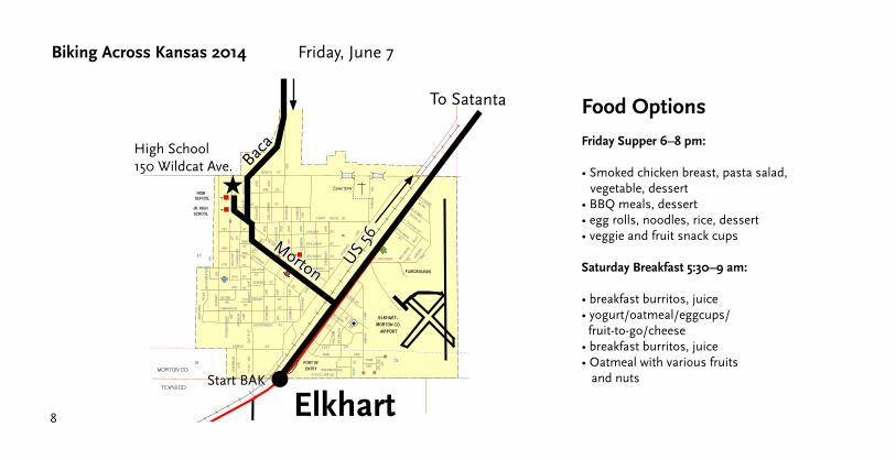
Biking Across Kansas 2014 Friday, June 7
N
S
US
56
High School150 Wildcat Ave.
To Satanta
★
Elkhart
Morton
Baca
Start BAK
Food Options
Friday Supper 6–8 pm:
• Smoked chicken breast, pasta salad, vegetable, dessert• BBQ meals, dessert• egg rolls, noodles, rice, dessert• veggie and fruit snack cups
Saturday Breakfast 5:30–9 am:
• breakfast burritos, juice• yogurt/oatmeal/eggcups/ fruit-to-go/cheese• breakfast burritos, juice• Oatmeal with various fruits and nuts

9
6/6 to 6/7 History Notes
Morton CountyCimarron National Grasslands – East of Elkhart on highway 56The government purchased 108,175 acres of land to restore it after being greatly damaged by the dust bowl. Today, it is managed for wildlife, livestock, water conservation, recreation, and mineral productions.
Tristate Point: Just 8 miles west of Elkhart, on State Line Rd., is a beautiful place to view the Cimarron Grasslands. The Eight Mile Corner is where Kansas, Oklahoma, and Colorado all meet. A windmill from 1903 marks it.
Elkhart: County Seat of Morton County. Founded 1912 by the railroad. Richfield used to be the county seat and had a two story stone courthouse, which was abandoned many years ago.
Friday, June 7 Route Guide

Biking Across Kansas 2014 Saturday, June 7
10
Today’s Destination City: Satanta
Overnight Lodging at: Satanta High School (100 Caddo St.)
Lunch Stop: Hugoton (more info at www.bak.org/2014/meals/)
Total Mileage: 62
Directions: Begin on US 56 at the Kansas/Oklahoma Border. Head northeast on US 56 to Hugoton. Left turn at Main St. in Hugoton and continue on US 56 to Satanta. Right turn on Caddo St. to High School.

Saturday, June 7 Route Guide
11
Elkhart to Rolla 18
Rolla to Hugoton 15.5
Hugoton to Moscow 13.5
Moscow to Satanta 15
Point-to-Point Mileage

12
51
CIMARRONNATIONAL
GRASSLANDS
27
56Elkhart
Cimarro
n River
56
ⓦWilburton
Rolla
Stev
ens
Cou
nty
Mor
ton
Cou
nty
5151
Mor
ton
Cou
nty
CO
LOR
AD
OK
AN
SAS
OKLAHOMA
KANSAS
12
Biking Across Kansas 2014 Saturday, June 7

13
Saturday, June 7 Route Guide
25
Stev
ens
Cou
nty
Mor
ton
Cou
nty
Hugoton51
25
56
56
“Watering Hole” in City Park at 4th and MainHomemade goodies,water, restrooms

14
Biking Across Kansas 2014 Saturday, June 7
Has
kell
Cou
nty
Stevens County
Seward County
Gra
nt C
ount
y
Stev
ens
Cou
nty
Moscow
56
Sew
ard
Cou
nty
56
56
Satanta
56
56
56
Sublette
83
83
56

Saturday, June 7 Route Guide
15
To Dodge
City
13
18 1714
23 24 19 20
293025
26
12 78
11
21
65
15
10
3
22
27
SEWAGE
DISPOSAL
PONDS
CEMETERY
DUDLEY
SATANTA
LANDING STRIP
TUSCARORA ST.
SHOSHONE ST.
MANDAN ST.PO
NC
AA
VE
.
SE
NE
CA
ST
.
MO
JA
VE
ST
.
PU
EB
LO
ST
.
OJIB
WA
ST
.
OSAG
E
AVE.
PO
NCA
AVE.
AVE.
WIC
HIT
A
ARAPAHO
E
AVE.
CHEYENNE
AVE.
AVE.
TO
NKAW
A
SHAW
NEE
AVE.
CHERO
KEE
AVE.
MO
DO
CKIC
KAPOO
AVE.
AVE.
TIS
HOM
INGO
LN.A
VE.
OTTA
WA
AVE.
OM
AHA
AVE.
PIU
TE
AVE.
PO
TTAW
ATO
MIE
AVE.
SEM
INO
LE
AVE.
SANTA
FE
AVE.
TUCUM
SEH
AVE.
WYANDO
TTE
WIN
NEBAG
O
AVE.
AVE.
NAVAJO
APACHE ST.
PAWNEE ST.
COMANCHE ST.
KAW ST.
OT
OE
ST
.
KIO
WA
ST
.
SE
QU
OY
AH
ST
.
SIO
UX
ST
.
CA
DD
OS
T.
ST.
NEZ PERCE
MOHAWK
ST.
TO
SUBLETTE
TO
MOSCOW
TO
JCT. US-83
&
US-160
190
TO
JCT. US-160
190
T 30 S
T 30 S
R 34 W R 33 W
R 34 W R 33 W
CO
UN
TY
R
OA
D "
EE
"
CO
UN
TY
R
OA
D "F
F"
CO
UN
TY
R
OA
D "
FF
"
CO
UN
TY
R
OA
D "
GG
"
CO
UN
TY
R
OA
D "
GG
"C
OU
NT
Y R
OA
D "
GG
"
CO
UN
TY
R
OA
D "
HH
"
CO
UN
TY
R
OA
D "
HH
"
CO
UN
TY
RO
AD
"H
H"
COUNTY ROAD #230 COUNTY ROAD #230 COUNTY ROAD #230
COUNTY ROAD #220 COUNTY ROAD #220 COUNTY ROAD #220
COUNTY ROAD #210 COUNTY ROAD #210
COUNTY ROAD #210
COUNTY ROAD #210
COUNTY ROAD #200 COUNTY ROAD #200
COUNTY ROAD #200
CIM
ARRO
N VA
LLEY RAILRO
AD
CIMARRON V
ALLEY RAILROAD
CVR
0
1000 2000
200 400 600 800 1000
03000 FEET
METERS
SCALE
FEDERAL HIGHWAY ADMINISTRATIONU.S. DEPARTMENT OF TRANSPORTATION
IN COOPERATION WITH THE
KANSAS DEPARTMENT OF TRANSPORTATION
BUREAU OF TRANSPORTATION PLANNING
POP. 1216
SOURCE
NORTH ZONEKANSAS COORDINATE SYSTEM,
PROJECTION -
-
POPULATION - U.S. BUREAU OF THE CENSUS 2000
LAMBERT CONFORMAL CONIC
7.5’ U.S.G.S. QUADRANGLE(1:24,000 SCALE)
CITY OF
of this information and assumes no liability for errors or omissions.KDOT makes no warranties, guarantees, or representations for accuracy
PREPARED BY THE
CERTIFIED TO SECRETARY OF STATE, 7/1/2003
SATANTAHASKELL COUNTY, KANSAS
T 30 S R 33 W R 34 W
DECEMBER, 2003
CORPORATE CITY LIMITS
LAND SECTION LINE
DIVIDED HIGHWAY
STATE HIGHWAY
STREET OR PUBLIC ROAD
RAILROAD
U.S. NUMBERED ROUTE
STATE NUMBERED ROUTE
INTERSTATE NUMBERED ROUTE
LEGEND
SCHOOL
HOSPITAL KDOT OFFICE
SPORTS COMPLEXCITY HALL
COUNTY COURT HOUSEMUSEUM
POST OFFICE
63
36
70
LOW WATER CROSSINGCUL-DE-SAC
SA
TA
NT
A #
521
SATANTA #521
CO
UN
TY
R
OA
D "H
H"
CO
UN
TY
R
OA
D "
GG
"
CO
UN
TY
R
OA
D "F
F"
CO
UN
TY
R
OA
D "
EE
"
56
56
US 56
High School100 Caddo St.
★
From Elkhart
Satanta

16
Biking Across Kansas 2014 Saturday, June 7
Worship OpportunitiesSatanta, Saturday, June 7Protestant Worship Service, High School 5:30 pm
Catholic Mass, High School 6:45 pm
Nursing Home VisitSatanta, Saturday, June 7Satanta Hospital Long Term Care401 Cheyenne St.2:30 to 4:30 pm
LunchSaturday, June 7, 11 am–2 pmSandwiches/Trail Mix/Fruit/Water PS 101 Youth Group
SupperSaturday, June 7, 5–7 pmHigh School Ag Building
Hamburgers/German FriesKnights of Columbus
Spaghetti (with or without meat)BreadBooster Club
Homemade Egg RollsFried Rice/DrinkHospital EAC
BreakfastSunday, June 8, 5:30–9 amHigh School Ag Building
Oatmeal Bar (raisins, nuts, etc.)Booster Club
Cinnamon Rolls/Muffins/CoffeeChamber of Commerce
Breakfast Burritos/JuiceOne Way Church
Biscuits and GravyShine Ministries
Breakfast CasseroleJuice/CoffeeUMW

17
6/7 History Notes
Hugoton: Settlers from McPherson, Kansas established a settlement in what was then west-central Seward County, Kansas in 1885. They originally named this settlement Hugo in honor of French writer Victor Hugo, but then changed its name to Hugoton to distinguish it from Hugo, Colorado.
Moscow: Formerly called New Moscow; successor of another Moscow eight miles south and moved her in 1913 to be on the railroad.
Haskell County is believed to be the origin of the 1918 Spanish Flu pandemic that infected 500 million people and killed 50 to 100 million worldwide.
Satanta: pop: 1,273 The town was established in 1912. The Railroad named it after the Kiowa Chief, Satanta, one of the signers of the Medicine Lodge Peace Treaty. There was such a negative reaction from naming a town after an Indian that it was the last town the Railroad agreed to name. See the wooden statue of Chief Satanta in front of the Satanta City Library and the permanent teepee in its park on US 56. Streets carry the names of Indian Tribes.
Saturday, June 7 Route Guide

Biking Across Kansas 2014 Sunday, June 8
18
Today’s Destination City: Spearville
Overnight Lodging at: High School (302 E. Ave B)
Lunch Stop: Dodge City
Total Mileage: 78
Directions: Leave Satanta on US 56 east. Continue on US 56 through Montezuma and Ensign. Left turn onto McArtor Road. Continue on McArtor to 2nd Ave. in Dodge City. Left turn onto 2nd Ave. and continue north to Wyatt Earp Blvd. Right turn onto Wyatt Earp and continue east on US 56 to junction with US 50. Right turn onto US 50/56 to Wright. Continue on US 56 to Spearville. Right turn onto Main St. Left turn onto Ave B to Spearville High School.

Sunday, June 8 Route Guide
19
Satanta to Sublette 9
Sublette to Copeland 13.5
Copeland to Montezuma 11
Montezuma to Ensign 12.5
Ensign to McArtor Rd turnoff 11
McArtor turnoff to Dodge City (Front St) 4
Dodge City to Spearville 17
Point-to-Point Mileage

2020
Biking Across Kansas 2014 Sunday, June 8
Has
kell
Cou
nty
Stevens County
Seward County
Gra
nt C
ount
y
Stev
ens
Cou
nty
Moscow
56
Sew
ard
Cou
nty
56
56
Satanta
56
56
56
Sublette
83
83
56
21
Sunday, June 8 Route Guide
Sublette
Has
kell
Cou
nty
Gra
y C
ount
y
19056
56
16083
56
�
Copeland
Montezuma
Ensign
Haggard
Ford
Cou
nty
Gra
y C
ount
y
5623
23ⓦ
�
Dodge City
56
5656
400
56
400283
283
50
50
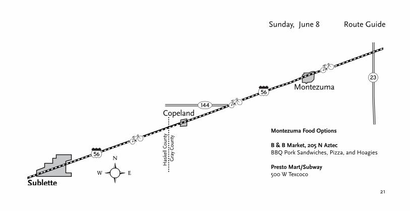
Montezuma Food Options
B & B Market, 205 N Aztec BBQ Pork Sandwiches, Pizza, and Hoagies
Presto Mart/Subway500 W Texcoco

Sublette
Has
kell
Cou
nty
Gra
y C
ount
y
19056
56
16083
56
�
Copeland
Montezuma
Ensign
Haggard
Ford
Cou
nty
Gra
y C
ount
y
5623
23ⓦ
�
Dodge City
56
5656
400
56
400283
283
50
50
McArtor
22
Biking Across Kansas 2014 Sunday, June 8
2nd
Wyatt Earp Blvd

Sunday, June 8 Route Guide
23
Dodge City
56400
50
400283
283
400
400 50
283
56
Wright
56
50 Spearville
50
50
ⓦ
56
56
Wyatt Earp Blvd
McArtor
2nd
24
Biking Across Kansas 2014 Sunday, June 8
CEMETERY
SILENT LAND
CEMETERY
ST. JOHNS
SEWAGE
DISPOSAL
PONDS
SANTA FE
AVE.
GILBERT
AVE.
WEST
AVE."A
"
WEST
AVE."B
"
AVE.
"B"
EAST
"A"
AVE.
EAST
DAVIS ST.
LEIDIGH ST.
AVE.
DOVE ST.
PIGEON ST.
GROUSE ST.
MIL
LE
R A
VE
.
MO
OD
YA
VE
.
ST
AF
FO
RD
ST
.
MA
INS
T.
STA
FFO
RD
ST.
ST.
PIN
EC
ED
AR
ST.
CLA
RK
ST.
ST.
VA
N
ST.
WA
LN
UT
OA
K
ST.
ELM
ST.
STA
FFO
RD
ST.
WE
ST
ER
NS
T.
PA
RK
ST
.
HA
LL
ST
.
ST
.S
OP
HY
ST
.S
ILL
SOUTHERN AVE.
3231
33
561
2930
28
2120
19
17 16
27
34
4 3
22
15
TO
DODGE CITY
TO
KINSLEY
R 22 W
R 22 W
T 25 S
T 25 S
T 26 S
T 26 S
CO
WCREEK
WH
ITE
WOMAN
CREEK
DENIM ROADDENIM ROAD
DENIM ROAD
EAGLE ROAD
(LAKE ROAD)EAGLE ROAD EAGLE ROAD
FOOTHILL ROADFOOTHILL ROAD
FOOTHILL ROAD(SPEARVILLE ROAD)
GARNETT ROAD
GARNETT ROADGARNETT ROAD
126 R
OA
D
126 R
OA
D
126 R
OA
D
127 R
OA
D
127 R
OA
D
127 R
OA
D
5 R
OA
D
4 R
OA
D
6 R
OA
D
7 R
OA
D
BURLING
TON
N
ORTH
ERN
SAN
TA
FE
RAILW
AY
BNSF
126 R
OA
D
125 R
OA
D
125 R
OA
D
DENIM ROAD
18
0
1000 2000
200 400 600 800 1000
0 3000 FEET
METERS
SCALE
FEDERAL HIGHWAY ADMINISTRATION
U.S. DEPARTMENT OF TRANSPORTATION
IN COOPERATION WITH THE
KANSAS DEPARTMENT OF TRANSPORTATION
BUREAU OF TRANSPORTATION PLANNING
POP. 843
SOURCE
NORTH ZONEKANSAS COORDINATE SYSTEM,
PROJECTION -
-
POPULATION - U.S. BUREAU OF THE CENSUS 2004
LAMBERT CONFORMAL CONIC
CITY OF
of this information and assumes no liability for errors or omissions.
KDOT makes no warranties, guarantees, or representations for accuracy
PREPARED BY THE
CERTIFIED TO SECRETARY OF STATE, 7/1/2004
FORD COUNTY, KANSAS
SPEARVILLET 25 S T 26 S R 22 W
CORPORATE CITY LIMITS
LAND SECTION LINE
DIVIDED HIGHWAY
STATE HIGHWAY
STREET OR PUBLIC ROAD
RAILROAD
U.S. NUMBERED ROUTE
STATE NUMBERED ROUTE
INTERSTATE NUMBERED ROUTE
LEGEND
SCHOOL
HOSPITAL KDOT OFFICE
SPORTS COMPLEXCITY HALL
COUNTY COURT HOUSEMUSEUM
POST OFFICE
63
36
70
LOW WATER CROSSINGCUL-DE-SAC
VIERTHALER ST.
QUAIL ST.
SPARROW ST.
AUGUST, 2004
FIFTH STANDARD PARALLEL SOUTH
FIFTH STANDARD PARALLEL SOUTH
R 2
2 W
R 2
3 W
MA
IN
ST.
WEST
AVE.
"C"
DORSET
SP
EA
RV
ILL
E #
543
SPEARVILLE #543
EAST AVE. ’
C’
R 2
2 W
R 2
3 W
R 2
2 W
R 2
3 W
13
24
25
36
2002 DIGITAL ORTHO QUARTER QUADS
5650
5056
To Ellinwood
US 56
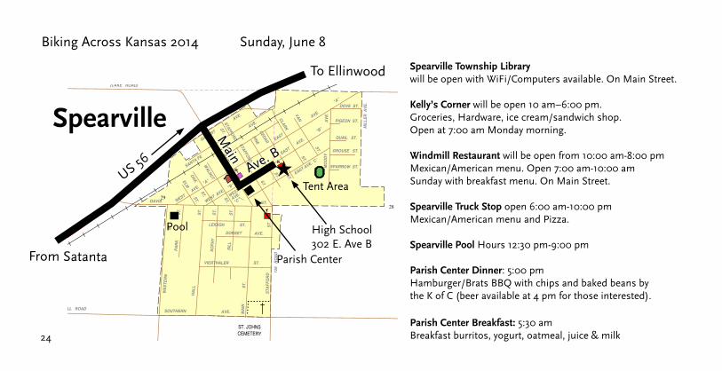
High School302 E. Ave B
★
Spearville
From Satanta
Main
Ave. B
Spearville Township Library will be open with WiFi/Computers available. On Main Street.
Kelly’s Corner will be open 10 am–6:00 pm. Groceries, Hardware, ice cream/sandwich shop. Open at 7:00 am Monday morning.
Windmill Restaurant will be open from 10:00 am-8:00 pm Mexican/American menu. Open 7:00 am-10:00 am Sunday with breakfast menu. On Main Street.
Spearville Truck Stop open 6:00 am-10:00 pm Mexican/American menu and Pizza.
Spearville Pool Hours 12:30 pm-9:00 pm
Parish Center Dinner: 5:00 pm Hamburger/Brats BBQ with chips and baked beans by the K of C (beer available at 4 pm for those interested).
Parish Center Breakfast: 5:30 am Breakfast burritos, yogurt, oatmeal, juice & milk
Pool
Parish Center
Tent Area

25
Sunday, June 8 Route Guide
6/8 History Notes
Sublette: pop: 1,453Named for William Lewis Sublette, a French Huguenot who was a partner in the Rocky Mountain Fur Company. An election in 1913 made Sublette the county seat. It was the first county election where Kansas women were allowed to vote. Sublette is the County seat of Haskell County. Many of the town’s streets are named after explorers, such as Zebulon Pike and Kit Carson.
Haskell County Historical Museum: N Fairgrounds in Sublette.
Gray County Wind Farm: Visitor’s kiosk is on the north side of US HWY 56, just east of Montezuma. The Gray County Wind Farm is the largest wind farm in Kansas.
Montezuma: pop: 966Stauth Memorial Museum: 111 N Aztec. The museum hosts traveling exhibits from the Smithsonian Institute and is home to other artifacts, art, and wildlife collections.
Ford County was named after Col. James Hobart Ford who was in charge of the construction of Ft. Dodge.
Dodge City: pop: 27,340Founded in 1872, near Fort Dodge, the town became the center for travelers and buffalo hunters. As the longhorn cattle started arriving from Texas, the city got its wild, cowtown reputation. Bat Masterson and Wyatt Earp fought to bring law and order to the town. Boot Hill Cemetery was necessary as shootouts were commonly used to settle differences. Boot Hill Museum and Historic Dodge City on Front Street. The historic exhibits show the life and times of Dodge City.
Spearville: pop: 802 In 1873, the Santa Fe to the Arkansas Valley Town Company bought the land and named the township after the railroad direc-tor, Alden H. Speare. However, the town got its start after two men from Chicago came out at night by train, and were “dropped in the prairie like a cat in a bag.” When daylight came, they liked what they saw and contacted the AT&SFRR Company wanting to purchase the town site. The deal went through on Dec. 6th 1877.

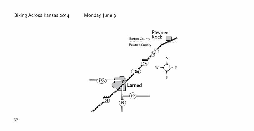
Biking Across Kansas 2014 Monday, June 9
26
Today’s Destination City: Ellinwood
Gym Lodging at: High School, 300 N. Schiller
Tenting at: Elementary School, 310 N. 6th
Lunch Stop: Larned (more info at www.bak.org/2014/meals/)
Total Mileage: 80
Directions: Leave Spearville on US 50/56 northeast. At Kinsley, exit right onto US 56. Stay on US 56 to Larned. Continue through Larned (US 56) and turn right at 14th St. (US 56/K-156). Continue on US 56 to Great Bend. Turn right onto 10th St. and continue to Main. Right turn on Main and continue to SE 20th Road. Left turn onto SE 20th Road, continue east to Ellinwood. In Ellinwood stay on Main St to 2nd St. Right turn to Schiller St. and High School. Tenters turn left on Schiller past High School) to Elementary School at 6th.

Monday, June 9 Route Guide
27
Spearville to Offerle 11.5
Offerle to Kinsley 8.5
Kinsley to Garfield 14
Garfield to Larned 10
Larned to Pawnee Rock 9
Pawnee Rock to Great Bend 13
Great Bend to Ellinwood 14
Point-to-Point Mileage

2828
Biking Across Kansas 2014 Monday, June 10
ⓦBellefont
Edw
ards
Cou
nty
Ford
Cou
nty
Offerle
Kinsley
183
Spearville
50 56
50
56
56
50
56

29
Monday, June 10 Route Guide
Pawnee CountyEdw
ards
Cou
nty
Garfield
Edwards County
Pawnee County
183
Pawnee Rock
156
1919
Barton County
Kinsley
183
50
56
56
56
Larned
15656
56
30
Biking Across Kansas 2014 Monday, June 9
Pawnee CountyEdw
ards
Cou
nty
Garfield
Edwards County
Pawnee County
183
Pawnee Rock
156
1919
Barton County
Kinsley
183
50
56
56
56
Larned
15656
56

Monday, June 9 Route Guide
31
96Ellinwood
Great Bend
Dundee
969656
56
281
Pawnee County
Pawnee Rock
Barton County
156
56ⓦ
156
281
10th St.
Mai
n
SE 20th Rd.

32
56
56 569696
96
PONDS
SEWAGEDISPOSAL
10 11
2
34 35
12
1
27
2022 23
26
36
25
24
7
6
8
53
31
30
19
32
29
RIVER
RIVER
ARKANSAS
ARKA
NSAS
T 20 SR
12W
R1 2
WR
11 W
R11
W
T 20 ST 19 S
T 19 S
KANSAS & OKLAHOMA RAILWAY
KANSAS & OKLAHOMA RAILWAY
KANSAS & OKLAHOMA RAILWAY
S.E.
80A V
E .
S.E. 20 ROAD
S.E.
90AV
E.S.
E.90
A VE .
PARK
AVE.
E. BARTON RD.
S.E.
100 A
V E.
S .E.
80A V
E .
S.E.
90A V
E .
N.E. 10 RD.
S.E.
80A V
E .
2ND
WILH
ELM
SANTA FE AVE.
FRIT
ZS T
.
1ST
"A"
ST.
CAM I
L LE
" E " CASCADERD.
RANDOMRD.
HUMB
O LT
A VE .
ST.
SANTA FE
HUMB
O LT
M AIN
S T.
"C"
"B"
"D"
BISM
A RK
A VE .
S CH I
L LE R
ST.
AVE .
ST.
SCHI
LLE R
BISM
ARK
G OE T
HE
S.E. 10 RD.ST.
S.E.20 RD.
S.E.
1 10 A
VE.
ST.
HIRS
CHAV
E.
AVE.
ST.
ST.
ST.
WIE
LAN D
H IRS
CHA V
E .
N.E. 10 RD.
KENN
E DY
A VE .
S.E.
110A
VE.
ST.
S.E.
1 00A
VE.
ST.
ST.
ST.
BEVERLYBONITA
AVE.
DR.
BONITAPL.
AVE.
AVE.
11TH ST.
10TH ST.
POHLMAN ST.
PEMBROKE LN.
OLD MANOR RD.
MAIN
S T.
ST.CRAIG
AVE.
K EN N
E DY
A VE .
CRAIG ST.
FRIT
Z
POHLMAN ST.
5TH
4TH
3RD
AVE.
6TH AVE.
7TH
DR.
ISER
NST
.
CLIFTON DR.
AVE.
H IRS
CHA V
E .
E. BARTON RD.
GREAT BENDTO
TOLYONS
CEMETERYELLINWOOD
CEMETERY
ST. JOSEPHS
ELLINWOODAIRPORT
ELLINWOOD # 167
ELLI
NWOO
D#1
67
MUSEUM
63SCHOOL
CUL-DE-SAC
CITY HALL
HOSPITAL
LEGEND
RAILROAD
STATE HIGHWAYDIVIDED HIGHWAYLAND SECTION LINES
CORPORATE LIMITS
STATE NUMBERED ROUTE
LOW WATER CROSSING
COUNTY COURT HOUSE
SPORTS COMPLEX
KDOT OFFICE
POST OFFICE
U.S. NUMBERED ROUTE
INTERSTATE NUMBERED ROUTE
STREET OR PUBLIC ROAD
3670
CITY OF
ELLINWOODBARTON COUNTY KANSAS
T 19 S,T 20 S, R 11 W, R 12 W
PREPARED BY THEKANSAS DEPARTMENT OF TRANSPORTATION
BUREAU OF TRANSPORTATION PLANNINGIN COOPERATION WITH THE
U.S. DEPARTMENT OF TRANSPORTATIONFEDERAL HIGHWAY ADMINISTRATION
JULY 2010POP. 2,035
POPULATION - U.S. BUREAU OF THE CENSUS 2000,CERTIFIED TO SECRETARY OF STATE, 7/1/2009PROJECTION - LAMBERT CONFORMAL CONIC,WITH TWO STANDARD PARALLELSAT LATITUDE 39 N AND 38 N
KDOT makes no warranties, guarantees, or representations for accuracyof this information and assumes no liability for errors or omissions.
0 1000 2000 3000 FEET
0 200 400 600 800 1000 METERS
SCALE
Biking Across Kansas 2014 Monday, June 9
Gym LodgingHigh School300 N Schiller
★
★
TentersElementary School310 N 6th
2nd St.
Schi
ller
Mai
n
Hir
sch
Ellinwood
From Spearville
To Salina
6th Hir
sch/
NE
110
thNursing Home Visit, 2:30–4:30 pmWoodhaven Care Center, 510 W. 7th St.
Food Booths: Area organizations will serve Barbecue, German Food and a host of other comfort foods. 12 pm–6 pm
Art Exhibition at Sentinel Gallery 12 pm–7 pm
Historic Underground Tunnel tours12 pm, 1 pm, 2 pm, 3 pm, 4 pm,5 pm Van will operate taking guests to the Kansas Wetlands Education Center, Historic SS. Peter and Paul Shrine and the Wolf Hotel: 1 pm–5 pm Downtown Merchants open 10 am–5 pm
Special Screening of the Wizard of Oz: 7 pm The Fire Escape Coffee House Open 1 pm–5 pm

33
6/9 History Notes
Kinsley: pop: 1,425 (county seat) This “Midwest City” is halfway between New York and San Francisco. It is 1,561 miles to each city. Roadside Park is located where US 50 and 56 join. There you will find the Edwards County museum, an old church, a sod house, and the AT&SF steam locomotive #3424.
Larned: pop: 4,054 (county seat) The city shares its name with the nearby Fort Larned, that operated from 1859 to 1878.
Pawnee Rock: pop: 249 Pawnee Rock State Historic Site (NRHP): Located One-half mile off US 56 and the town of Pawnee Rock. American Indians used the Rock as an observation point to look for herds of buffalo as well as the wagons coming along the Santa Fe Trail. Some travelers believed this spot to be the most dangerous along the Trail, while others saw the rock as a welcomed sight, as it signified that half of their journey was behind them.
Great Bend: pop: 15,923 Named for its location at the “great bend” of the Arkansas River, the town was incorporated around 1872. It was a shipping hub for cattle and the town grew into a rowdy cow town for a while.
Ellinwood: pop: 2,120 Founded in the 1870s by German immigrants, the town had a two-block business district. However, below ground, there was another set of stores and businesses, connected by underground walkways. At one time, it included 11 saloons. Coal bins for the businesses lined the walkways, and the sidewalks above ground, would be pried open on days the coal was delivered. As natural gas replaced coal, the town started shrinking and the underground businesses closed. Ellinwood’s Underground Tunnels at the Dick Building: located on the NW corner of Main and Santa Fe, (US 56 at the stoplight). Walk through passageways to three of “yesterday’s underground shops” and hear how prohibition affected Ellinwood and its “Little German” reputation.
Monday, June 9 Route Guide

Biking Across Kansas 2014 Tuesday, June 10
34
Today’s Destination City: Salina
Overnight Lodging at: Salina Central High School
Lunch Stop: Ellsworth (more info at www.bak.org/2014/meals/)
Total Mileage: 72
Directions: Leave Ellinwood, head east on 2nd or 6th Street to Hirch St. Left turn onto Hirsch (traffic on Hirsch does not stop).Continue north to junction with K-156. Right onto K-156, continue to Ellsworth. Several lunch options in Ellsworth. Return to K-156 and Blake St., head east to Kanopolis. In Kanopolis, turn left onto Missouri Ave, head north on K-111 to K-140. Right turn onto K-140 to Crawford St in Salina. Turn right onto Crawford and continue east to Salina Central High School at Crawford and Front St.

Tuesday, June 10 Route Guide
35
Ellinwood to Jct K-156 8
Jct K-156 to Holyrood 12
Holyrood to Ellsworth 14
Ellsworth to Kanopolis 4
Kanopolis to Jct K-140 2.5
Jct K-140 to Brookville 16
Brookville to Salina 15.5
Point-to-Point Mileage

3636
Biking Across Kansas 2014 Tuesday, June 10
Ellinwood
969656
56
156
Claflin4
156
Salin
e C
ount
y
Ells
wor
th C
ount
y
⁄��
Kanopolis
4
14
156
14 156
156
156Holyrood
Carneiro 141
111
KanopolisLake
Bar
ton
Cou
nty
Ric
e C
ount
yEl
lsw
orth
Cou
nty
Bar
ton
Cou
nty
Ellsworth County
Rice County
111EllsworthMushroom Rock
State Park
NE
110
th

37
Tuesday, June 10 Route Guide
Ellinwood
969656
56
156
Claflin4
156
Salin
e C
ount
y
Ells
wor
th C
ount
y
⁄��
Kanopolis
4
14
156
14 156
156
156Holyrood
Carneiro 141
111
KanopolisLake
Bar
ton
Cou
nty
Ric
e C
ount
yEl
lsw
orth
Cou
nty
Bar
ton
Cou
nty
Ellsworth County
Rice County
111EllsworthMushroom Rock
State Park Ave. L
BlakeMissouri Ave.
Lunch OptionHwy 156 & Kunkle
Knights of Columbus8 am to 2 pm

38
Biking Across Kansas 2014 Tuesday, June 10
Brookville
�Sa
line
Cou
nty
Ells
wor
th C
ount
y
Dic
kins
on C
ount
y
Salin
e C
ount
y
Solomon
Salina
New Cambria
81
707070 70
Crawford St.

Tuesday, June 10 Route Guide
39
81
81
81
40
81
4040
40
140
143
140
143
70
135
135
70
135
70
70
13
12
18
7
1 6
36 31
17
8
5
32
2530
2419
29
20
9
4
33
15
10
3
34
28
21
27
22
13
12
18
7
1 6
17
8
5
3631
2530
2419
32
20
29
16
9
4
15
10
3
33
28
16
21
34
27
22
14
11
2
35
13
12
1
36
26
23
25
24
18
7
6
31
17
8
16
9
5
32
4
33
30
19
2928
2021
14
11
2
13
12
1
35
26
23
36
25
24
18
7
6
17
8
16
9
5
4
31
30
19
32 33
29
20
28
21
COLLEGE OFKSU-SALINA
HEARTSACRED
SCHOOLHIGH
WESLEYANKANSAS
UNIVERSITY
PARKOAKDALE
SCHOOLMILITARYST. JOHNS
HIGH SCHOOLSALINA SOUTH
JERRY IVEY
PARK
HIGH SCHOOLSALINA CENTRAL
TECHNOLOGY
COURSEGOLF
PARK
BURKEBILL
CEMETERYGYPSON HILL
TRAINING ACADEMYKS. HIGHWAY PATROL
MULBERRY
CREEK
SALINE
DRY
CRE
EK
DRY
SMOKY
HILL
RIVE
R
SMO
KY
HIL
L
RIVER
CRE
EK
OLD
RIVER
MULBERRY
CREEK
SALINE
SMOKY HILL
RIVER CHANNEL
SMOKY
HILL
RIVE
R
RIVER
T 14 S
T 15 S
T 14 S
T 14 S
R 3 W
R 3 W
R 2 W
T 15 S
R 2 W
T 14 S
T 13 ST 13 S
Abandoned Railroad Grade
UNION PACIFIC SYSTEM
Abandoned Railroad Grade
(KYLE RAILROAD SYSTEM)
KANSAS & OKLAHOMA RAILWAY
Aban
done
dRail
road
Grad
e
Abandoned Railroad Grade
UNION PACIFIC SYSTEM
KANSAS & OKLAHOMA RAILWAY
UNION PACIFIC SYSTEM
SUNSET
KENWOOD PARK
PARK
BURM
A R
D.
WATERWELL RD.
BURM
A R
D.
HALS
TEAD
RD.
MAGNOLIA RD.
CLOUD RD.
CRAWFORD RD.
CLOUD RD.
CRAWFORD RD.
AIRP
ORT
RD.
FAIR
CHILD
S -
GERA
RD R
D.
SCAN
LAN
CENT
ENNI
AL -
TRE
SSIN
RD.
VORTEX ST.
WALL ST.
ARNO
LD
BAILEY
JUMPER
SCHILLING
AVE.
AVE.
SUMMERS
SUTHERLAND
GENERAL JIM
RD.
RD.
RD.
OHLKE RD.
GANEY RD.
LUCASRD.LO
W A
VE. DERUSSY
RD.
KINGSTON
RD.
RD.
GLENSHIRE
FAIRWAY
DERBY ROYA
L
ST.
CANT
ERBU
RY
AVE.
AVE.CT.
HARTFORD ST.
DR.ST.FLINT
DR.
CRESENT
BRITTANY DR.
AVE.
FLORIDA
SPRINGFIELD
ST.
DR.
MIDLAND ST.
CRESENT DR.CRESENT DR.
CT.
HUNTER
AUGUSTA
ST. GEOR
GIA
ST.
BERS
CHEL
LAV
E.
RD.
ALBANY ST.
BEECHCRAFT
HEIN
RD.
HEIN
RD.
HAYES RD.
RD.
CROMPTON RD.
RD.BURCHINAL
CENT
ENNI
AL
TONY'S RD.
COMM
ERCE
CT.
WES
TWOO
DST
.SY
CAMO
RE
DOVER
KENNYAVE.
PAGE
YALE
ST.
TEAKWOOD ST.
ANDREW ST.
INGM
AN
WINONA
HICK
ORY
BEAC
H OAK
ST.
RD.
CLOU
DST
.
CIRCL
E
CIR.
WILLOW
WILL
OW
CRAWFORD ST.
WES
TPOR
TBL
VD.
DR.
BEND DR.SHADY
BEVERLY
ST.ST. LOUIS
GRAV
ESBL
VD.
ST.CH
EROK
EE
BACHTOLD
ST.
PAWNEE
APAC
HEDR
.
KIOWA
CHEYENNE
CT.WOOD
RED
DR.
BIRC
H
PLUM
HEML
OCK
DR.
NAVA
HO
AVE.PUEBLO
DR.
AVE.
PONT
IAC
COMMANCHE AVE.
ST.
AVE.
OAK
DR.
AVE.
ARAPAHOE AVE.
AVE.
AVE.
ACORN CIR.
PONCA
AVE.
CHAC
TOW
AVE.
REPUBLIC
SENE
CAAV
E.
FRANKLIN
AVE.
OSAG
E
WIN
DSOR
DR.
AVE.
VASS
ARDR
.
DR.
CYPRESS DR.
VERM
ONT
WHI
TTIN
GHILL
DR.JA
MESO
NAV
E.RO
CKET
AVE.
AVE.
AVE.
BEVERLY
STEA
HLIN
G
HAVEN
DUVA
LL
AVE.
DUVALL
BROA
DWAY
AVE.
AVE.
DR.
ARMORY
STATE RD.
ARMSTRONG RD.
STIMMEL RD.
PLEASANT HILL RD.
WATKINS RD.
HALS
TEAD
RD.
HALS
TEAD
RD.
ARMSTRONG RD.
ASH
WHITE AVE.
SMIT
HER
ST.
CHER
RY
ORAN
GEST
.
ST.
CHAD
ST.
ROBE
RTS AV
E.
SCAN
IAN
AVE.
DIXIE AVE.
KAY ST.
SCOTT AVE.
W. REPUBLIC AVE.
TRES
SIN
RD.
NORTH ST.
STIMMEL DR.
CENT
ENNI
AL-
TRES
SIN
RD.
GERA
RDRD
.FA
IRCH
ILDS
-GER
ARD
RD.
CENT
ENNI
AL-
TRES
SIN
RD.
WATKINS RD.
STEV
ENS
-LAM
ERRD
.
STEV
ENS
-LAM
ERRD
.
BERG ST.
CROWN
CT.
NOBLE
CARR
IAGE
CIR.
MERRILY
SOMERSET CIR.
DR.
MERRILY
ALAB
AMA
DR.
FOXB
ORO
DR.
HUEHL
MARC
ELLA
DR.
CIR.
RD.DUSTINCIR.HUEHL
CIR.BANNER
CT.
DR.SOMERSET DR.
RAINBOW DR.GREENBRIARFL
ORID
AAV
E.
DR.EVERGREEN
DR.
HOOV
ERCT
.
TAFT
CT.
TAYL
ORCT
.
VIRGINIA
GREE
NBRI
ARCI
R.
9TH.
ST.
DEBOLD
PLACE
AVE.
(B) AVE.
(A) AVE.
(C)A
VE.
SCHILLING RD.
TAKS
ERLN
.
CT.CT.
CT.
TR.
BENJAMIN
PLACESAM'S MARKET
HIGH
LAND
ST.
MARK
EPL
.
BELMONT
SUMM
ER LN.
AVE.
MORLAND
KEY
SIMM
ONS
CT.
GAIL DR.
KAREN
ANTLER
BERK
LEY
TAKSER
LAURA ST.
IRENE ST.
SCOTT AVE.
ALLE
NST
.
BLVD.
DALE
Y ST.
AVE.
ROCK
HURS
TRD
.
RAY
HEARTLAND
PARKWAY
NEAL
ROBI
N
AVE.
AVE.
AVE.
OHIO
RD.
COMM
ERCE
ST.
WATERWELL RD.
LISA
LN.
LINDA
LA.
SCOTT
PATT
Y
LINDA
LA.
COLO
NIAL
LN.
POST OAK LN.
DR.
CT.COLONIAL
COLONIAL
BRET
AVE.
OAKLAWN
DR.
MIKE DR.
BRET AVE.
BOBB
YPL
.
MELA
NELN
.
AVE.
AVE.
LN.
PLAN
TATI
ONDR
.
BURR OAK LN.
MAGNOLIA RD.
LN.
MEADOWLARK
NEP
MARS
AVE.
TUNE
AVE.
SATURN
JUPITER
VENUS
HAGE
MAN
AVE.
MERCURY AVE.
AVE.
AVE.
OTTO
HAROLD
TALLEY
CARLTON
DR.
HASK
ETT
LENA
AVE.
TULANE AVE.
GARDEN AVE.
AVE.
AVE.
BEL AIR
ST.
MAPLE
WILLIS AVE.
SMITH AVE.
MARVIN AVE.
AVE.
YALE AVE.
AVE.
PURDUE AVE.
AVE.
TULANE
AVE.
RUSH
CLOUD
WOODLAWN
AVE.
ST.
PLAN
ETAV
E.9T
H.ST
.
DRAK
EPL
.
REED AVE.
HART ST.
LELA
NDRA
YMON
DAVE.
HIGH
LAND
9TH.
ST.P
L.
SIMM
ONSPL.
EMMA
LESLIE
LARS
ON
CLAFLIN
AVE.
CHARLOTTE
AVE.
ST.
ST.
WAYNE
4TH.
GEBH
ART
AVE.
WAY
AVE.
ALBERT
ST.
ST.
ST.
OSBO
RNE
VASS
ARDR
.
DOVE
RDR
.
CORO
N ADO
ST.
FUNS
TON
ST.
PLAZ
ADR
.
HANC
OCK
WILSON
MERR
ILL
SERI
DAN
ST.
CT.
SOUTH
PERS
HING
ST.
NORT
HCT
.
11TH
.ST. HI
GH10
TH.S
T. JEWELL
LAND
CIR.
CUST
ER
SHER
MAN
11TH
.
10TH
.
ST.FAIRVIEW
TENL
AWN
ST.
CRAWFORD
ILLINOIS
VENANGO
ST.
ST.
RD.
HOLIDAY
MONT
ROSE
COLL
EGE
DR.
ST.
ST.
12TH
.
CHARLES
PL.
FROST
BROWNST.
ST.
11TH
.
10TH
.
PHILL
IPS
MORRISON
ST.
PRESCOTT
WASHINGTON ST.
ST.
ST.
ST.
SUNSET DR.
BELOIT
ELLSWORTH
MINNEAPOLIS
ST.
SANT
AFE
WILSON
ST.
5TH.
3RD.
ST.LAMAR
ST.
ANDERSON
RAHM ST.ST
.
ST.
ST.
ST.
BOND ST.
PUTN
AMAV
E.
WEIL PL.
ST.
WOO
DST
.
2ND.
ST.
3RD.
ST.
AVE.
CENTER ST.
DR.SAXWOOD
BELM
ONT
DR.MONTCLAIR
MAYFAIR DR.
LA SHELLE
KENSINGTON
BLVD.
WESLEYEDW
ARDS
EDWARDS
RD.
LN.
ST.
ST.
AORO
RAAV
E.
OHIO
ST.
ST.
ROACHNOTTINGHAM
ST.
LEWISOXFORD
QUIN
CY
LESLIE
NORT
ON
AVE.
AVE.CARL
RALPH
MAX
ST.
ST.
ST.
AVE.
AVE.
NORT
ON RUSSELL
ROAC
H
PENTWOOD DR.
MARC
LEW
IS
AVE.
DR.SHALIMAR
AVE.BUCKEYE
AVE.
ST.
ST.
AVE.
AVE.
FAW
NST
.
SCHIPPELDR.
DR.REVERE
DR.
DR.
SEQUOIA
HUNT
INGT
ONRD
.
DR. BENTLY
SHER
WOO
DLN
.
AVE.
DR.
MARTIN
ST.
ROAC
H
AVE.
AVE.
AVE.
AVE.
DR.
LAMBERTS
ON
CORSAUTCT.
PARKWOOD
GLENDALE
MISSION
LA.
RD.BR
IARW
OOD
DR.
DR.
LYNN DR.
AUST
INCI
R.
AUST
INCI
R.
CLOUD ST.
CIR.ST
.
SUNR
ISE
DR.
FRON
T KENI
SON
RD.
MCADAMS
AVE.
MORNINGSIDE
MELLINGER DR.
AVE.
PEAR
L
AVE.
ARROWHEAD
JACK CIR.
LN.
LINDA LN.
CORT
LAND
CIR.
ENTE
RPRI
SEDR
.
CIR.
ELKH
ORNQU
AILR
UN
WHI
TETA
ILW
AY
MOUR
NING
DOVE
LN.
CEDAR CREEKDR.
YOST
DR.
RIFF
ELDR
.
RD.
BEAT
RICE
AVE.
AVE.
TWIN OAKS LN.
OAK LN.
TARA
LN.
ST. GUERNSEY
ELMO
REDR
.
DR.
YMCA
DR.
WESTCHESTER
ST.
MILLWOOD DR.
PRESCOTT
MANOR DR.
RD.
WES
TBEN
D
WAV
ERLY
ELMHURST BLVD.
DR.
EDISON PLACE
LOUISE LANE
ELLSWORTH
MINNEAPOLIS
AVE.
MANC
HEST
ER MEYER
FREDRICH DR.
MARTIN AVE.
DR.
COUR
TNEY
DR.
RICKY
EAST
GATE
DR.
BRADSHAW DR.
RD.
MOUN
DVIE
WAV
E.
LEFR
ANST
. PLACESYLVAN
MEAD
OWBR
OOK
FAITH DR.
RD.
RD.
ROCK
VIEW
JAPA
NST
.
BEAK
SHIR
EDR
.
INDIAN
WESTCHESTER DR.
STRATFORD DR.
ARLINGTON DR.
ROCK
PARK
UPPE
RMI
LL
AMBA
SSAD
ORDR
.
BLAK
EMOO
REDR
.
MITC
HELL
DR.
CALC
UTTA
DR.
PINN
ACLE
DR.
TETONLN.
MAGNOLIA RD.
SIRRA DR.
SCHILLING RD.
DUND
EELN
.
ANGU
SLN
.
HOLM
ESRD
.
WATERWELL RD.
CREEK
MACLEAN GLEN
COE
CREE
K ST. ANDREWS LN.
CLOUD ST.
VALL
EYVI
EWDR
.
VICT
ORIA
CT.
RIDGE
COLU
MBIN
ELN
.
VIEW
MARY
MOUN
TST
.
TERR.
RD.
FAIRDALE
HOLL
YLN
.
HEIG
HTS
TERR
.
VICT
ORIA
HEIG
HTS
DR.
STAR
LIGHT
DR.MILL
UPPER
UPPE
RMI
LLHE
IGHT
SDR
.HE
IGHT
SRD
.
QUEE
NSRD
.DR
.
E. CRAWFORD ST.
ASPEN
DR.
BRIA
RCLIF
FRD
.
COUNTRY
PHEASANT
RIDGELEA
CLAR
EMON
TDR
.
CAMD
EN
REGE
NTRD
.LYNWOOD
RUSKIN RD.
AULL
WOC
RD.
COLU
MBIN
ECI
R.
COLUMBINE
CT.
DR.
CT.
CT.
GOLF
VIEW
MARK
LEY
DR.
HILLS
FAIR
DALE
RD.
RD.
LN.
GEOR
GETO
WN
VILLAGE
APPLEWOOD
BEEC
HWOO
DRD
.
CRES
TWOO
DRD
.
BROOKWOOD
WIN
N
NORTHWOOD
RD.
GLEN
N
PHEA
SANT
PHEASANT
CT.
LN.
LN.
LN.
STEWART
LN.
RD.
DR.
LA.
SEIT
Z
LN.
GREY
STON
EDR
.
MAGNOLIA RD.
ESTA
TEDR
.
HORIZON
DR. WIN
DSON
GVI
STA
CT.
LN.
BLUE
STEM
CEDAR RIDGE DR.
E. CLOUD ST.
DR.
BRIA
RGAT
E
BARLOW
FAIR
WAY
ESTA
TE
EASTRIDGE DR.
BARLOWCT.
REDTOP RIDGE
CT.
CLOUD RD.
VALL
EYVIE
WDR
.
PINE
RIDG
EDR
.MA
RKLE
YDR
.
MARIPOSA DR.
NOVA
LN.
PRAI
RIECT
.
CHUKAR
QUAIL
DR.HOLLOW
CT.
CLOUD ST.
HOLM
ESRD
.
SOUTH
SUN DR.
MOON DR.
STAR DR.
STAR CIR
11TH
. ST.
RD.
SARAH DR.
LINDEN LORIANNASHALIMAR
SHERWOOD
LN.
CT.ADAM TRAVIS
EAGLECREST AVE.
AIDANCT.
RIVE
RTR
AIL
RD.
PLAZA DR.
CENTURY
CHIC
AGO
WALNUT WES
T
SPRUCE ST.
CEDAR ST.
UNIVERSITY
MARIETTA
ST.
AVE.
ST.
STATE
PL.
AVE.
BAKE
R 12TH
.
11TH
.
ST.
IRON
13TH
ST.
12TH
11TH
.
PARK
PL.
ELM
CHIC
AGO
LOGAN
BARN
EYST
.
ST. ST
.
ST.
ST.
ST.
REYN
OLDS
13TH
.
LINCOLN
ST.
12TH
.
11TH
.
GRAND
10TH
.
8TH.
9TH
ST.
7TH.
MULBERRY ST.
AVE.
ST.
ST.
3RD.
2ND.
5TH.
ST.
ST.
BISHOP ST.PINE ST.
10TH
.
9TH. 8T
H.
7TH.
AVE.
DECATUR
ST.
ST.
ST.
LINCOLN
AVE.
AVE.
AVE.
FOREST AVE.
ST.
WOODLAND
PACIFIC
HARSH
ST.
ST. HAMILTON
ANTRIM
ST.
ST.
ST.
SANT
AFE
ST.
INEZ AVE.
AVE.
OTIS
5TH. 4T
H.
3RD.
2ND.
ST.
AVE.
AVE.
ST.
AVE.
ST.
AVE.
AVE.
ST.
EUCLID AVE.
5TH.
ST.
PARK PL.SMOKY
GYPSUM
JOHNSTOWN
OAKD
ALE
HILLDR.
HAZEL CT.
OHIO
ST.
AVE.
FRON
T
AVE.
PENN
AVE.
YORK
COLU
MBIA
AVE.
RIVERSIDE DR.
AVE.
KANS
AS
ST.
DES
MOIN
ESAV
E.
NORTH
AVE.
CONN
ECTI
CUT
DELA
WAR
E
AVE.
AVE.
MISS
OURI
STACK AVE.
INDI
ANA
AVE.
AVE.
STAPLER
AVE.
ST.POPLAR
AVE
GLENNIFER
HILLDR.
INDIAN ROCK
WIS
CONS
IN
AVE.
MICH
IGAN AV
E.
AVE.
IOW
AAV
E.
VAN HORNE ST.
PROSPECT
ROOS
EVEL
T
AVE.
IDLE
WILD
E
DEWEY ST.
AVE.
ST.
WOODLAND AVE.
DIAMOND
COACHH
LIG
PLEASANT HILL RD.
TLN .
MONARCH
FRON
TAGE FR
ONTA
GE
DR.
GOLD RD.
GRANVILLE RD.
9TH
ST.
OHIO
ST.
HANN
ARD
.
GRANVILLE RD.
OHIO
RD.
SCHIPPEL RD.
RD.
GLEN AVE. TERR.
MARY
MOUN
TST
.
KNOLLCREST
LN.
MILLVIEW
HILLCREST
DR.MT. BARBARA
W.P
ARK
ST.
DR.
NORTH ST.
W. LAKE
MARCYE LN.
TINA WAY
E. GRAY RD.
W. HILLSIDE
ST.
HILLSIDE
EDGEHILL
MELROSE
RD.FA
IRDA
LE
HILLSIDE TERR.
DR.
RD.
MEADOW LA.
GREENWAY
E.PA
RKST
.
OVERHILL RD.
CRESTVIEW
COUNTRY CLUB RD.
LA.
ESTA
TE
DOUG
LAS
HILL
DALE
RD.
DR.
RD.
DR.
DR.
EAST
BORO
UGH
RD.
RD.
OLD FORTY HIGHWAY
DR.
DR.
SKYL
INE
DR.
PRES
LEY
ARGONNE DR.
DEBORAN DR.
BRAD
LEY
EAST
MOOR
DR.
STATE RD.
DR.RESORT
HOLM
ESRD
.
STIMMEL RD.
CRYS
TALS
PRIN
GSRD
.
ELLSWORTH
JCT. K-14TO
MINNEAPOLISTO
TO
TO
TO
McPHERSON
JCT. U S 81
SOLOMONTO
GYPSON HILL CEMETERY
MEMORIAL PARK CEMETERY
SALINAMUNICIPAL AIRPORT
SALI
NA #
515
SALINA # 515
MUSEUM
63SCHOOL
CUL-DE-SAC
CITY HALL
HOSPITAL
LEGEND
RAILROAD
STATE HIGHWAYDIVIDED HIGHWAYLAND SECTION LINES
CORPORATE LIMITS
STATE NUMBERED ROUTE
LOW WATER CROSSING
COUNTY COURT HOUSE
SPORTS COMPLEX
KDOT OFFICE
POST OFFICE
U.S. NUMBERED ROUTE
INTERSTATE NUMBERED ROUTE
STREET OR PUBLIC ROAD
3670
CITY OF
SALINASALINE COUNTY KANSAS
T 13 S, T 14 S, T 15 S, R 2 W, R 3 W
PREPARED BY THEKANSAS DEPARTMENT OF TRANSPORTATION
BUREAU OF TRANSPORTATION PLANNINGIN COOPERATION WITH THE
U.S. DEPARTMENT OF TRANSPORTATIONFEDERAL HIGHWAY ADMINISTRATION
AUGUST 2011POP. 47,707
POPULATION - U.S. BUREAU OF THE CENSUS 2000,CERTIFIED TO SECRETARY OF STATE, 7/1/2010PROJECTION - LAMBERT CONFORMAL CONIC,WITH TWO STANDARD PARALLELSAT LATITUDE 39 N AND 38 N
KDOT makes no warranties, guarantees, or representations for accuracyof this information and assumes no liability for errors or omissions.
0 1000 2000 3000 FEET
0 200 400 600 800 1000 METERS
SCALE
★
Crawford St.
Salina CentralHigh School650 E. Crawford
SalinaFood VendorsOakdale Park
BAK 40th Year Celebration 8:30 pmHigh School Auditorium

40
Biking Across Kansas 2014 Tuesday, June 10
6/10 History Notes
Cheyenne Bottoms Refuge: located near highway 156, get a glimpse of the largest marsh in the interior United States. It is considered the most important shorebird migration point in the Western Hemisphere, with around 45 percent of the North American shorebird population stopping at the Bottoms during spring migration.
Ellsworth: pop: 3,116 Founded in 1867, the town was known for being one of the wildest cow towns, with numerous shootouts and killings between cowboys. It was once said, “Abilene, the first, Dodge City, the last, but Ellsworth the wickedest.” By the 1870s, crime began to drop as the cattle drives moved to other places like Dodge City and Abilene.
Dinner and Music in Oakdale Park4:00 – 8:00 p.m.Featuring the Salina Municipal Band and Food Vending
Upper Road:#12 Butch’s Bar B Que—serving: Sandwiches—beef or pork; Ribs; BBQ Beef-n-Pork Cheese Fry Stacker;Jumbo Turkey Leg; French Fries w/cheese, w/chili cheese; Creamy Cole Slaw; Baked Beans; Coke Products.
#18 Mermaid Café & Grill—serving: Gyro—Chicken/Lamb/Steak/Seafood; Quesadilla Dinner; Lob-ster & Seafood Combo Dinner; Souvlaki Dinner; Sautéed Eggplant Dinner; Greek Salad w Pita; Hummus Plate; Veggie Pita; Fried Green Tomato; Assorted Greek Pastries; Frozen Drinks; Tea, Pepsi Products.
Lower Road by Eric Stein Stage:#7 C.J. Griffin Co., Inc—serving: Indian Taco; Fry Bread; Roasted Corn; Stuffed Cucumbers: pop, Cherry Limeade; Lemonade; Crème Soda.
#6 University United Methodist Church—serving: Bierocks; Funnel Cakes; Apple or Cherry Slush, Water.

41
Hodgden House Museum Complex: 104 SW Main Street: This two-block site is Ellsworth’s original commercial district. The 1878 Victorian home, Hodgden House, is located here along with other buildings, including the train depot, a one-room schoolhouse, a log cabin and a wooden windmill.
Kanopolis: pop: 491 Founded in 1887, the town was given its name, for it predicted it would be the “Central Metropolis” of the state and the eventual capitol.
Fort Hawker Museum Complex: 308 W Ohio: The fort was built to protect local settlements as well as travelers on the Smokey Hill and the Santa Fe Trails. It was ordered closed in 1872. Here, you will see the Junior Officer’s Quarters, the Original Guardhouse, and the depot along with early history exhibits.
Brookville: pop: 268 The town got its first start when the railroad reached the area in 1867. For a time it was the last stop west of Salina, making it a big cattle shipping point, as cattle were driven up the Chisholm Trail and loaded onto freight cars headed east.
Salina: pop: 55,600 William A. Phillips founded the town in 1858. The railroad and cattle trade brought a population boom in the 1870s, and the cultivation of wheat helped drive an agricultural industry. The jeans maker, Lee, opened its first factory here in 1889.
Named after subsurface salt deposits. At one time Salina ranked third in the U.S. in flour milling. It had five local mills producing 10,000 barrels of flour daily. Schilling Air Force Base, active in WWII, is now one of the largest municipal airports in the nation. Smoky Hill Museum in Oakdale Park. Famous Cozy burgers located in same location since 1922 (108 North 7th).
Tuesday, June 10 Route Guide

42
Biking Across Kansas 2014 Wednesday, June 11
Today’s Destination City: Wamego
Overnight Lodging at: Wamego High School
Lunch Stop: Junction City or Manhattan
Total Mileage: 88
Directions: Leave Salina heading east on Crawford to Simpson Rd. Left turn on Simpson to Old US 40. Right turn on Old 40 to Abilene. Right turn on 3rd to Rodgers. Left to 8th St., right to Vine St., left to 14th St. Right turn onto 14th, east to US 77. Left turn on 77 to Goldenbelt in Junction City. Continue to Washington St. Right onto Grant (turns into Custer). Enter Fort Riley and continue northeast on Huebner Rd to Ogden. Left onto Skyway to Scenic Dr. Right onto Scenic, through roundabouts to Stagg Hill Rd. Left turn continue to Ft. Riley Blvd in Manhattan. Right to 17th St. Turn left to Poyntz. Right onto 3rd St. to Pierre, continue to Zeandale Rd (K-18) Left turn onto K-18 to K-99. Left on K-99 to Wamego High School at 8th St.
43
Wednesday, June 11 Route Guide
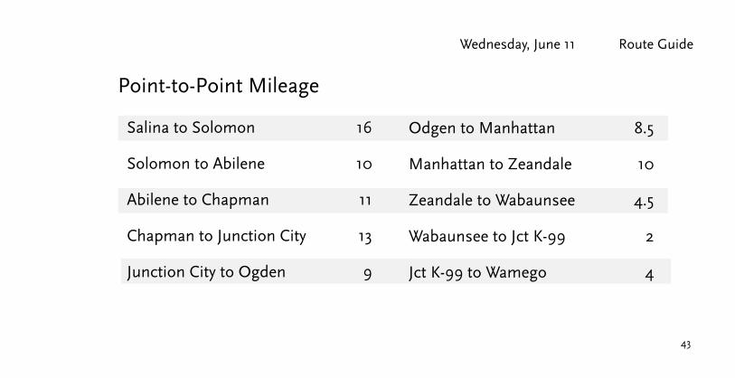
Salina to Solomon 16
Solomon to Abilene 10
Abilene to Chapman 11
Chapman to Junction City 13
Junction City to Ogden 9
Point-to-Point Mileage
Odgen to Manhattan 8.5
Manhattan to Zeandale 10
Zeandale to Wabaunsee 4.5
Wabaunsee to Jct K-99 2
Jct K-99 to Wamego 4

4444
Biking Across Kansas 2014 Wednesday, June 11
Brookville
�
Sain
e C
ount
y
Ells
wor
th C
ount
y
Dic
kins
on C
ount
y
Salin
e C
ount
y
Solomon
Salina
New Cambria
7070
81
70
Crawford
Old US 40
Sim
pson
Rd.

45
Wednesday, June 11 Route Guide
Solomon
�
Gea
ry C
ount
y
Dic
kins
on C
ount
y
Dic
kins
on C
ount
y
Salin
e C
ount
y
Abilene
Enterprise
Chapman15
15 43Solomon
Abilene
Chapman
70
70
70
Old US 40
Old US 40
3rd
14th

46
Biking Across Kansas 2014 Wednesday, June 11
Pottawatomie County
Riley Co.Manhattan
Fort RileyMilitaryReservation
�G
eary
Riley County
Dic
kins
on
MilfordLake
Junction City
Ogden
GrandviewPlaza
244
57
57
18
77
7718
18
113
177
24
177St. George
�
Pott
awat
omie
Cou
nty
KANSAS RIVER
St. Mary's
WamegoBelvue
2424 24
18 18
99
99
99
⁄��Zeandale
⁄��Wabaunsee
Shaw
nee
Cou
nty
70
70
114
Fort Riley Entrance(Photo ID required)
Huebner Rd.
Goldenbelt
Grant
Was
hing
ton
Skyway
Drive
Cust
er
Cla
rk’s
Cre
ek R
oad
6th

Wednesday, June 11 Route Guide
47
Pottawatomie County
Riley Co.Manhattan
Fort RileyMilitaryReservation
�
Gea
ry
Riley County
Dic
kins
on
MilfordLake
Junction City
Ogden
GrandviewPlaza
244
57
57
18
77
7718
18
113
177
24
177St. George
�
Pott
awat
omie
Cou
nty
KANSAS RIVER
St. Mary's
WamegoBelvue
2424 24
18 18
99
99
99
⁄��Zeandale
⁄��Wabaunsee
Shaw
nee
Cou
nty
70
70
114
Poyntz
Skyway
Drive
Stagg Hill Rd.
17th
PierreScenic Dr.
48
Biking Across Kansas 2014 Wednesday, June 11
24 2424
99
99
99
17
8
16
9
6
5
31
18
3233
15 14
1011
4
3
3
2
3435
SCHOOLU.S.D. 320 HIGH
WAMEGO
ELEMENTARY
SCHOOLMIDDLE
SCHOOL
WEST
WAMEGO
R 10 E
T 10 S T 10 S
R 10 E
T 9 S T 9 S
UNION PACIFIC SYSTEM
UNION PACIFIC SYSTEM
TRAILER
WAMEGO COUNTRY CLUB PARKPENNYLAND
PARK
PARK
CITY PARK
TRAILER
TRAILERPARK
WAMEGO COUNTRY CLUBTOOLS PLANT
CATERPILLAR WORK
TRAILERPARK
PARKINDUSTRIALWAMEGO
COLUMBIAN
CIR.RUTHSRU
THS
LANE
. CIR.OAKHILL
HORS
ESHO
ERD
.
MILITARY TRAIL RD. 72
CIR.
LNARBOR
OAKH
ILLDR
.
CATCIR.
CREEK
CAT CREEK DR. CIR.FEESS
MARSHA
ANTELOPE CREEK RD.
LN.
RIVE
RVIE
WDR
.
WAR
NOW
CIR.
2ND
WILS
ONCI
R.LN
.
DEBO
RAH
PARK
VIEW
RIVE
RVIE
WDR
.
1ST
3RD
ST.
WAL
NUT
4TH CHES
TNUT
5TH
SPRU
CE
POPL
ARST.
VINE
ST.
ST.
ELM ST
.
POPL
AR
SANDUSKYAVE.
ANTELOPE CREEK RD.
ELM
ST.
PRAI
RIE
CIR.CAMERON
WARREN
ROAD
CIR.
STAGE
RIDG
EDR
.
TRAILMEADOW
COLU
MBIA
NRD
.
HENRY DR.
RIDGE
CREEK
CREEKWILLOW
PL.
LN.WILLOW CREEK
LANE
DEER
ADAM
CLUBGRANDVIEW
DR. COUNTRY
CIR.
GENN
DR.
LILA
DR.
SIDE
NUS
COUNTRY CLUBDR.
DR.
AVE.
TES
D .R
HILL
CRES
TRD
.
DR.
MORNING
KAW
VALL
EY
PARK
CIR.
DR.FARRELL
CIR.COMMERCIAL
CLIFFORD DR.
14TH
KAW
15TH
16TH
6TH
ST.
7TH
ST.
8TH
ST.
WAL
NUT
ST.
10TH ST. LILAC
ST. ST.
ST.
ST.
TERR.9TH ST.
POPL
AR
VINE
10TH ST.ST
.
CHRYSLERDR.
LN.
ST.
MANSFIELDJULIE
CIR.
DR.
PENN
YLN
.
ST.
ST.
LILAC
VINE
ST.
ST.
GRAVES RD.(PRIVATE DR.)
PEEB
LELA
NE
NEFF ROAD
VALL
EYRD
.379
PINE
LANE
EBEL ROAD
ASHL
EY
ROAD KAW
VAL L
E YR D
.
17TH ST.
18TH ST.
LN.
AVE.
LEW
ISW
I LSON
RD.
VALLEY
ASH
PINE
ST.
LINCO
LN
ST.
RAILROAD ST.
MAPL
E
ST.
ST.
BALD
ERSO
N
DUTCH MILL RD. 451
RIVER BEND RD. 30
RED TOP RD. 56
(PRI
VATE
DR.
)
DUTC
HMI
LLRD
. 451
VALLEY RD. 42
6TH ST. RD. 54LEACH
6TH ST.SYCAMORE
DR.
REDWOODDR.PLUMMERCIR.SIMMERDR.CECILA
CIR.TROUTCIR. J.C
.ROG
ERS
LN.
CIR.
8THAV
E. ST.
PINE
4TH ST.
ST.
ASH
10TH
ST.
ST.9TH
ST.
MAPL
E
OAK
LOCU
ST
ST.
ST.
ST.
ST.LIN
COLN
MAPL
E
HIGH ROAD
SAY ROAD 86
ST.
PLUM
ST.
ST.
ST.
BLVD
.
INDU
STRI
AL
BLVD.
BRYANT ROAD 122
SPENCER ST.
WAL
SHRO
A D4 1
CUTOFFMILL
ER
DR.
OLD POST ROAD 88
KANSA SOUT
HWIN
DDR
.
LOUI
SVI
EUX
RD.
LANESHANOTE
MILITARY TRAIL RD. 72
OLD
LOUI
SRD
.
KANS
AS
RIVE
R
KANSAS
KANSAS
RIVER
RIVER
TO
MANHATTANTO
LOUISVILLETO
I-70
BELVUETO
CEMETERY
CEMETERY
ST. BERNARD
WAMEGO
POTTAWATOMIE CO.
WABAUNSEE CO.
POTTAWATOM
IE CO.
WABAUNSEE CO.
WAM
EGO
# 591
WAMEGO # 591
MUSEUM
63SCHOOL
CUL-DE-SAC
CITY HALL
HOSPITAL
LEGEND
RAILROAD
STATE HIGHWAYDIVIDED HIGHWAYLAND SECTION LINES
CORPORATE LIMITS
STATE NUMBERED ROUTE
LOW WATER CROSSING
COUNTY COURT HOUSE
SPORTS COMPLEX
KDOT OFFICE
POST OFFICE
U.S. NUMBERED ROUTE
INTERSTATE NUMBERED ROUTE
STREET OR PUBLIC ROAD
3670
CITY OF
WAMEGOPOTTAWATOMIE COUNTY KANSAS
T 9 S, T 10 S, R 10 EPREPARED BY THE
KANSAS DEPARTMENT OF TRANSPORTATIONBUREAU OF TRANSPORTATION PLANNING
IN COOPERATION WITH THEU.S. DEPARTMENT OF TRANSPORTATIONFEDERAL HIGHWAY ADMINISTRATION
JUNE 2011POP. 4,358
POPULATION - U.S. BUREAU OF THE CENSUS 2000,CERTIFIED TO SECRETARY OF STATE, 7/1/2010PROJECTION - LAMBERT CONFORMAL CONIC,WITH TWO STANDARD PARALLELSAT LATITUDE 39 N AND 38 N
KDOT makes no warranties, guarantees, or representations for accuracyof this information and assumes no liability for errors or omissions.
0 1000 2000 3000 FEET
0 200 400 600 800 1000 METERS
SCALE
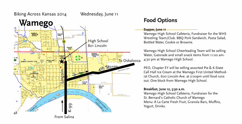
High School801 Lincoln
★Li
ncol
n
Wamego
4th St.K
-99
From Salina
To Oskaloosa
Food Options
Supper, June 11Wamego High School Cafeteria, Fundraiser for the WHS Wrestling Team/Club. BBQ Pork Sandwich, Pasta Salad, Bottled Water, Cookie or Brownie.
Wamego High School Cheerleading Team will be selling Water, Gatorade and small snack items from 11:00 am-4:30 pm at Wamego High School.
PEO, Chapter EY will be selling assorted Pie & K-State Call Hall Ice Cream at the Wamego First United Method-ist Church, 600 Lincoln Ave. at 2:00pm until food runs out. One block from Wamego High School.
Breakfast, June 12, 5:30 a.m.Wamego High School Cafeteria, Fundraiser for the St. Bernard’s Catholic Church of WamegoMenu: A La Carte Fresh Fruit, Granola Bars, Muffins, Yogurt, Drinks.
49
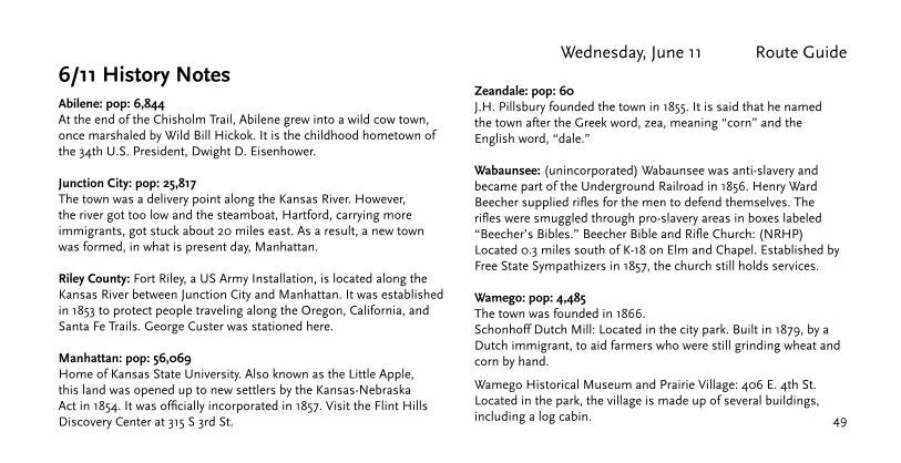
Wednesday, June 11 Route Guide6/11 History Notes Abilene: pop: 6,844 At the end of the Chisholm Trail, Abilene grew into a wild cow town, once marshaled by Wild Bill Hickok. It is the childhood hometown of the 34th U.S. President, Dwight D. Eisenhower.
Junction City: pop: 25,817 The town was a delivery point along the Kansas River. However, the river got too low and the steamboat, Hartford, carrying more immigrants, got stuck about 20 miles east. As a result, a new town was formed, in what is present day, Manhattan.
Riley County: Fort Riley, a US Army Installation, is located along the Kansas River between Junction City and Manhattan. It was established in 1853 to protect people traveling along the Oregon, California, and Santa Fe Trails. George Custer was stationed here.
Manhattan: pop: 56,069 Home of Kansas State University. Also known as the Little Apple, this land was opened up to new settlers by the Kansas-Nebraska Act in 1854. It was officially incorporated in 1857. Visit the Flint Hills Discovery Center at 315 S 3rd St.
Zeandale: pop: 60 J.H. Pillsbury founded the town in 1855. It is said that he named the town after the Greek word, zea, meaning “corn” and the English word, “dale.”
Wabaunsee: (unincorporated) Wabaunsee was anti-slavery and became part of the Underground Railroad in 1856. Henry Ward Beecher supplied rifles for the men to defend themselves. The rifles were smuggled through pro-slavery areas in boxes labeled “Beecher’s Bibles.” Beecher Bible and Rifle Church: (NRHP) Located 0.3 miles south of K-18 on Elm and Chapel. Established by Free State Sympathizers in 1857, the church still holds services.
Wamego: pop: 4,485 The town was founded in 1866.Schonhoff Dutch Mill: Located in the city park. Built in 1879, by a Dutch immigrant, to aid farmers who were still grinding wheat and corn by hand.
Wamego Historical Museum and Prairie Village: 406 E. 4th St. Located in the park, the village is made up of several buildings, including a log cabin.

50
Biking Across Kansas 2014 Thursday, June 12
Today’s Destination City: Oskaloosa
Overnight Lodging at: Oskaloosa High School
Lunch Stop: Silver Lake or Jct US 75
Total Mileage: 66
Directions: Leave Wamego, south on K-99 to 4th St. Left on 4th past Windmill Park to US 24. East on US 24 through St. Mary’s to Silver Lake. In Silver Lake, left onto Railroad St., then left onto Hoch Rd. Continue to NW 46th St and turn right. Continue east, passing under US 75. Turn left onto Button Rd, continue to 62nd St. Right onto 62nd St and head east to Meriden Rd. Left turn onto Meriden to 82nd St. Right turn on 82nd St to Meriden. Left turn on Main St to K-4. Left turn on K-4 to junction of K-92. Right turn on K-92 to Oskaloosa. Left turn on Liberty St. to High School.

51
Thursday, June 12 Route Guide
Wamego to Belvue 8
Belvue to St. Mary’s 6
St. Mary’s to Rossville 7.5
Rossville to Silver Lake 5.5
Silver Lake to Button Road 9.5
Button Road to NW 62nd 2
Point-to-Point Mileage
NW 62nd to Meriden Road 4.5
Meriden Road to NE 82nd St. 3
NE 82nd St to Meriden (K-4) 3.5
Meridan to Jct K-92 3.5
Jct K-92 to Ozawkie 4
Ozawkie to Oskaloosa 9

5252
Biking Across Kansas 2014 Thursday, June 12
Pottawatomie County
Riley Co.Manhattan
Fort RileyMilitaryReservation
�
Gea
ry
Geary County
Riley County
Dic
kins
on
MilfordLake
Junction City
Ogden
GrandviewPlaza
244
57
57
18
77
77
7018
18
113
177
24
177St. George
�
Pott
awat
omie
Cou
nty
St. Mary's
WamegoBelvue
2424 24
18 18
99
99
99
⁄��Zeandale
⁄��Wabaunsee
Shaw
nee
Cou
nty
63
4th St.

53
Thursday, June 12 Route Guide
Jeff
erso
n C
ount
y
Shaw
nee
Cou
nty
Shaw
nee
C
ount
y
Pott
awat
omie
Cou
nty
St. Mary’s
Rossville
�
Jeff
erso
n C
ount
y
Jack
son
Cou
nty
PerryLake
Meriden
Ozawkie
Oskaloosa
4
4
4
24 24
24
24
75
75
92 92
1692
16
59
63
Silver Lake 4
59
�NW 46th St.
Hoc
h R
d. But
ton
NW 62nd St. Mer
iden
Rd.
NE 82nd St.
Main St.
Restaurants
Railroad St.

54
Biking Across Kansas 2014 Thursday, June 12Je
ffer
son
Cou
nty
Shaw
nee
Cou
nty
Shaw
nee
C
ount
y
Pott
awat
omie
Cou
nty
St. Mary’s
Rossville
�
Jeff
erso
n C
ount
y
Jack
son
Cou
nty
PerryLake
Meriden
Ozawkie
Oskaloosa
4
4
4
24 24
24
24
75
75
92 92
1692
16
59
63
Silver Lake 4
59
�
6/12 History Notes
St. Marys: pop: 2,656 In 1848, the Pottawatomie first arrived in the area, they were given 30 square miles of land along the Kansas River. They set up a mission and a church, which served as a resting place for those traveling along the Oregon Trail. It was incorporated as a city in 1869. With that, came the formation of the public school system, and the grounds that had held the mission school became St. Mary’s College.
Ozawkie: Named for a Sac Indian chief. Translation given to the name is “yellow earth.”
Oskaloosa: pop: 1,096 The town’s newspaper, Oskaloosa Independent, began publishing July 11th, 1860, and the masthead proudly states: “Six Months Older Than the State of Kansas.”

59
59
59
7
6
8
5
31 32
29
9
10
43
3334
32
3028 27
OAK
BURR
SLOUGH
CREE
K
BRANC
H
SLOUGH
CREEK
T 9 S T 10 S
R 19 E
R 19 E
T 10 S
T 9 S
82ND ST.
OSAG
ERD
.
OSAG
ERD
.
90TH ST.
OSAG
ERD
.
82ND ST.
TOPEKA ST.
LEAVENWORTHST.
ELM
ST.
WES
TVIE
W
MONROE
ATCHISON
ELM
ST.
UNIO
N
LAWRENCELIB
ERTY
DELA
WAR
E
MADISON
JEFFERSON
NEMAHA RD.
102ND ST.
OLD K 92 NEMA
HARD
.
NEMA
HARD
.
102ND ST.
OSAG
ERD
.
TURK
EYRU
N
98TH ST.
CIR.
KANSAS ST.
ST.J
OSEP
HST
.
COLU
MBIA
HERKIMER
ST.
PARK
COLU
MBIA
ST.
HAMILTON
WASHINGTON
ST.
ST.
ST.
ST.
110TH ST.
DR.
94TH ST.
WARREN ST.
98TH ST.
86TH ST.
CHER
OKEE
WAL
NUT
ST.
ST.
ST.
ST.
ST.
JEFFERSON ST.
RENO RD.
ST.
ST .
ST.
ST.
SYCA
MORE
ST.
ST.
FAIRVIEW RD.
McCA
LLDR
.
WARREN ST.
FAIRVIEW RD.
RAW
LINS
RD.
94TH ST.
103RD ST.
RENO
RD.
RAW
LINS
RD.
WARREN ST.
92
16
16 92
92
16
OZAWKIE
TO
MC LOUTHTO
NORTONVILLETO
LAWRENCE
TO
PLEASANT VIEWCEMETERY
OSKA
LOOS
A # 4
40
OSKALOOSA # 440
MUSEUM
63SCHOOL
CUL-DE-SAC
CITY HALL
HOSPITAL
LEGEND
RAILROAD
STATE HIGHWAYDIVIDED HIGHWAYLAND SECTION LINES
CORPORATE LIMITS
STATE NUMBERED ROUTE
LOW WATER CROSSING
COUNTY COURT HOUSE
SPORTS COMPLEX
KDOT OFFICE
POST OFFICE
U.S. NUMBERED ROUTE
INTERSTATE NUMBERED ROUTE
STREET OR PUBLIC ROAD
3670
CITY OF
OSKALOOSAJEFFERSON COUNTY KANSAS
T 9 S, T 10 S, R 19 E
PREPARED BY THEKANSAS DEPARTMENT OF TRANSPORTATION
BUREAU OF TRANSPORTATION PLANNINGIN COOPERATION WITH THE
U.S. DEPARTMENT OF TRANSPORTATIONFEDERAL HIGHWAY ADMINISTRATION
OCTOBER 2009POP. 1,106
POPULATION - U.S. BUREAU OF THE CENSUS 2000,CERTIFIED TO SECRETARY OF STATE, 7/1/2008PROJECTION - LAMBERT CONFORMAL CONIC,WITH TWO STANDARD PARALLELSAT LATITUDE 39 N AND 38 N
KDOT makes no warranties, guarantees, or representations for accuracyof this information and assumes no liability for errors or omissions.
0 1000 2000 3000 FEET
0 200 400 600 800 1000 METERS
SCALE
Thursday, June 12 Route Guide
55
High School404 Park St.
★
Oskaloosa
US
59
From Wamego
To Hiawatha
K-92 Warren
Libe
rty
Supper: Oskaloosa Boston Trip 2015 Fundraiser Group from 2:00 to 9:00 pm. Location will be in the Oskaloosa High School Multi-purpose Room. Chicken and noodles with a salad bar.
Supper: The United Methodist Church of Oskaloosa will be serving a Mexican food supper from 3:00 pm to 9:00 pm. Five blocks directly south of Oskaloosa High School.
Ice cream: Homemade ice cream from 3:00 pm to 9:00 pm., high school parking lot.
Breakfast: Oskaloosa Boston Trip 2015 Fundraiser Group from 5:30 to 9:30 am. Location will be in Oskaloosa High School Multi-purpose Room. The menu will be biscuits and gravy with fresh fruit.
Breakfast: The Friends of Hospice, serving from 5:30 to 9:00 am in the Oskaloosa High School Commons Area. They will serve breakfast sandwiches on English muffins with combination options of egg, cheese, veggies, bacon and sausage. Also being served will be yogurt, fresh fruit, juice and coffee.
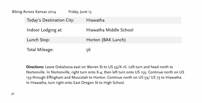
56
Biking Across Kansas 2014 Friday, June 13
Today’s Destination City:
Indoor Lodging at:
Lunch Stop:
Hiawatha
Hiawatha Middle School
Horton (BAK Lunch)
Total Mileage: 56
Directions: Leave Oskaloosa east on Warren St to US 59/K-16. Left turn and head north to Nortonville. In Nortonville, right turn onto K-4, then left turn onto US 159. Continue north on US 159 through Effingham and Muscotah to Horton. Continue north on US 59/ US 73 to Hiawatha. In Hiawatha, turn right onto East Oregon St to High School.

57
Friday, June 13 Route Guide
Oskaloosa to Nortonville 14
Nortonville to Effingham 12
Effingham to Muscotah 8.5
Muscotah to Horton 8.5
Horton to Hiawatha 13
Point-to-Point Mileage

5858
Biking Across Kansas 2014 Friday, June 13
�
PerryLake
Meriden
Ozawkie
Oskaloosa
4
492 92
1692
1659
59
4Nortonville
16
59
59
�
192
Jefferson County
Atchison County
4

59
Friday, June 13 Route Guide
�
PerryLake
Meriden
Ozawkie
Oskaloosa
4
492 92
1692
1659
59
4Nortonville
16
59
59
�
192
Jefferson County
Atchison County
4

60
Biking Across Kansas 2014 Friday, June 13Horton
Muscotah
EffinghamMonrovia
73
73
Brown County
Atchison County
73
Nortonville
9
9
20
Jefferson County
BAK Lunch in HortonFriday, June 13th
Provided By Horton Area Churches
The Blue Community Building
716 1st Avenue West
Serving from 9:00 a.m. to 2:00 p.m.

Friday, June 13 Route Guide
61
73
Hiawatha
�
�20�
73
73
Horton
Brown County
Atchison County
Hiawatha Food OptionsAg Museum, 301 E Iowa St: Bison Burgers, Brats, Cole Slaw, Chips, and a Drink. Transportation is available tothe Ag Museum from the High School. 3–8 pm
Downtown Food Booths, 601 Oregon St. 3–8 pm• Homemade Ice Cream, Snow Cones • HS Biology club: chicken and veggie wraps, pasta salad• Little Hands Daycare: walking tacos and baked goods• Class of 2017: Bake Sale• Energy Extreme: Hiawatha Cross Country. Offering Protein and energy bars, energy drinks and rehydration drinks• Rho Lambda Sorority: Pulled Pork tacos• Team Hawks Wrestling: Hot Dogs, Hamburgers, Drinks, Chips and Homemade Pie

62
CORPORATE CITY LIMITS
LAND SECTION LINE
DIVIDED HIGHWAY
STATE HIGHWAY
STREET OR PUBLIC ROAD
RAILROAD
U.S. NUMBERED ROUTE
STATE NUMBERED ROUTE
INTERSTATE NUMBERED ROUTE
LEGEND
SCHOOL
HOSPITAL KDOT OFFICE
SPORTS COMPLEXCITY HALL
COUNTY COURT HOUSEMUSEUM
POST OFFICE
63
36
70
LOW WATER CROSSINGCUL-DE-SAC
0
1000 2000
200 400 600 800 1000
03000 FEET
METERS
SCALE
FEDERAL HIGHWAY ADMINISTRATION
U.S. DEPARTMENT OF TRANSPORTATION
IN COOPERATION WITH THE
KANSAS DEPARTMENT OF TRANSPORTATIONBUREAU OF TRANSPORTATION PLANNING
PROJECTION -
POPULATION - U.S. BUREAU OF THE CENSUS 2000
LAMBERT CONFORMAL CONIC
CITY OF
of this information and assumes no liability for errors or omissions.
KDOT makes no warranties, guarantees, or representations for accuracy
PREPARED BY THE
CERTIFIED TO SECRETARY OF STATE, 7/1/2006
WITH TWO STANDARD PARALLELSo oAT LATITUDE 39 N AND 38 N
13 18 17
2419 20
1615
2122
272829
3332
36
25
30
TO
RESERVE
MUNICIPAL
AIRPORT
HIGHLAND
TO
TO
HORTON
TO
FAIRVIEW
R 1
6 E
R 1
7 E
T 2 S
CEMETERY
MT. HOPE
CEMETERY
WOODBURY LN.
WE
NT
LE
Y
DR
.
NAVAJO AVE.
PAWNEE PAWNEE PAWNEE
AVE.
AVE. AVE.
CHEYENNE
CHEYENNE
CHEYENNE AVE.
AVE.
AVE.
CHEROKEE CHEROKEEAVE. AVE.
KANSAS AVE.
HIAWATHA
HIAWATHA
AVE.
AVE.
MIAMI MIAMIST. ST.
SHAWNEE ST.
DELAWARE
OREGON
UTAH
KICKAPOO
POTTOWATOMIE
IOWA
12T
HS
T.
11T
H11T
HS
T.
ST
.
10T
HS
T.
9T
H9T
HS
T.
ST
.
8T
H
8T
H
ST
.
ST
.
7T
H
7T
H
ST
.S
T.
6T
H
6T
H
ST
.
ST
.
5T
H5T
HS
T.
ST
.
4T
H4T
HS
T.
ST
.
3R
DS
T.
2N
DS
T.
1S
TS
T.
SO
UT
H1S
TS
T.
SO
UT
H2N
DS
T.
MINNEHAHA AVE.
OSAGE AVE.
SIOUX AVE.
MOHAWK AVE.
MIN
NETARELN
.
S. 4T
H S
T.
IRO
QU
ISD
R.
MOHAVE
ST.
AVE.
LODGE
RD.
SO
UT
H7T
H S
T.
SO
UT
H 10T
H S
T.
SO
UT
H12T
HS
T.
IND
US
TR
IALAPACHE ST. APACHE
ST.
13T
H S
T.
SO
UT
H3R
DS
T.
MINNETARE SHOSHONE
SEQUOIA
LN.
NAVAJO AVE.
NO
RT
H
CHIPPEWA
LN.
OTTAWA
LN. CHICKASAWLN.
QUIVIRACT.
APACHE
ST.
MO
RR
ILL
AV
E.
RE
DW
ING
DR
.
COMANCHE
COMANCHE
DR.
CT.
RD
.
LN.
LONGFELLOW
ST.
HIAWATHA
SENIOR HIGH
SCHOOL
EUCHRE
CREEK
NORTH
FORK
WOLF
RIVER
RD
.
CHOC TAW
MINNEHAHA
HIAWATHA
HURON
CT.
FO
X R
UN
SEMINOLE
CT.
SEMINOLE
CT.
KIOWA
CT.
WEST OREGON ST.
AV
E.
ST.
ST.
ST.
ST.
ST.
ST.
EAST
OREGON
ST.
RE
DS
KIN
DR
.
LODGE
RD.
HATFIELD RD.
34
R 1
6 E
R 1
7 E
T 2 S
T 3 S
UNION PACIFIC SYSTEM
UN
ION
PA
CIFIC
SYSTEM
UN
ION
PA
CIF
IC S
YSTEM
UN
ION
PA
CIF
IC S
YSTE
M
HIAWATHABROWN COUNTY KANSAS
T 2 S, T 3 S, R 16 E, R 17 E
JANUARY, 2007POP. 3,236
HIAWATHA # 256
HIA
WA
TH
A #
256
31
3636
36
159
73
159
73
159
73
Biking Across Kansas 2014 Friday, June 13
★High School
600 Red Hawk Drive
Hiawatha
Oregon
Miami
1st S
t.
Courthouse(Food Booths &
Evening Meeting)
To Highland
From Oskaloosa
BAK Breakfast Saturday, June 14Chris Cakes serving at 6 am in the Hiawatha High School.
Schedule of Events9:00 am–8:00 pm: Morrill Public Library—enjoy air conditioning, free Wi-Fi, & board games.
1:00–8:00 pm: Information Booth available at the High School & Courthouse Lawn
3:00–8:00 pm: Food offerings available on the Courthouse Lawn and the Ag Museum.
6:00–8:00 pm: Musical Entertainment on the courthouse lawn provided by:Kingfisher and Doug Weinberg.
8:00 pm: BAK meeting on Courthouse lawn.

63
6/14 History Notes
Old Jefferson Town: Located on highway 59 outside Oskaloosa. The buildings have origins from around Jefferson County, and were relocated, giving a neat view of how early settlers once lived.
Muscotah: pop: 175 Named for the Kickapoo Native American word for “prairie,” it was founded in 1857. The town was originally settled two and a half miles northeast of its current location. However, when the founders learned that the Union Pacific Railroad would be just south, they relocated the town on the railroad line near the river.
Brown County was organized in 1855 and named after Albert G. Browne, of Mississippi, who had been Senator and member of the House of Representatives from that state. The name is properly spelled with an “e” in the original statute, but on the county seal, the “e” was left off—accidentally, probably. All later statues present the name without the final “e.” The Kickapoo Nation Indian Reservation in Brown County is the second largest Indian reservation in Kansas.
Horton: pop. 1,883Post Office Murals (NRHP): 825 1st Avenue. Kenneth Evett is the artist for two pieces of Section artwork installed in 1939.
Hiawatha: pop: 3,133 Nicknamed the “City of Beautiful Maples” the town was founded in 1857. It was named after Henry Wadsworth Longfellow’s poem, The Song of Hiawatha. There is a method to their street names. Main street, (Oregon Street), was named after the Oregon Trail. East-west streets that are north of Oregon Street are named after Indian Tribes who lived north of the Oregon Trail and those that lived south are south of Oregon Street.
Davis Memorial: (NRHP) A monument in the Mount Hope Ceme-tery, it was built by John Milburn Davis to honor his late wife, Sarah. It cost approximately $200,000, which brought great criticism of Davis’ spending during the Great Depression.
City Clock: 701 Oregon Street: Built in 1891 as part of a bank, it is the only clock of its kind between Denver and Indianapolis on U.S. Route 36.
Friday, June 13 Route Guide

64
Biking Across Kansas 2014 Saturday, June 14
Today’s Destination: Missouri River
Celebration Dinner: Highland
Total Mileage: 35
Directions: Leave Hiawatha High School west on Oregon St to 1st St. Right turn onto 1st St (US 159/73), continue to Miami St. Right turn onto Miami St (240th St). East to Prairie Road, left turn onto Prairie Rd. North to 310th. Right turn on 310th to White Cloud and Missouri River. Leave White Cloud and turn south onto K-7. South on K-7 to 240th Rd. Right turn onto 240th to Highland. Celebration dinner on campus of Highland Community College.

65
Saturday, June 14 Route Guide
Hiawatha to White Cloud (Missouri River) 20
White Cloud to Highland 15
Total BAK Mileage 555
Point-to-Point Mileage

66
Biking Across Kansas 2014 Saturday, June 14
Don
ipha
n C
ount
y
Bro
wn
Cou
nty
NEBRASKA
White Cloud
Sparks
ⓦ
MIS
S
O UR I R IV ER Iowa Point
Highland
Hiawatha
73
73
7
7
7
ⓦMiami St. 240th Rd.
Prai
rie
Roa
d
240th Rd.
310th St.

67
Saturday, June 14 Route GuideSEWAGE
PONDSDISPOSAL
36
36
4
33
3
34
28
21
27
22
15 14
2
35
1
36
26
23
25
13
24
16
COLLEGECOMMUNITYHIGHLAND
MIS
SION
CREEK
T 2 S
T 3 S
R 19 E
R 19 E
T 2 S
T 3 S
220 TH RD.
CAST
LETO
NRD
.
220 TH RD.
BUFF
ALO
RD.
250 TH RD.
CAST
LETO
NRD
.
PRAI
RIE
ST
PENNSYLVANIA
SOUT
H
ELMI
RA
AVE
VIRGINIA
IVES
ST
IOW
A
KANS
AS
ST
NEBR
ASKA
VERM
ILLI O
N
ST
ST ST
ST
NORT
HAV
E
ST
ST
VERMONT
MISSOURI
ST ST
ST
ST ST
N.CA
ROLI N
AST
.
ST
ST
CORO
NADO
RD.
DIAM
OND
SPRI
NGS
DR.
230 TH ROAD
DIAM
OND
SPRI
NGS
DR.
220 TH RD.
DENM
ARK
RD.
S.CA
ROLI
NAST
.
MAIN
WAL
NUT
ELM
240 TH RD.
WES
TAV
E.
KIRK
WOO
D
GENE
SEE
OHIO
ILLINOIS
MAIN
ST
CANA
DAST
.
ST
ST
SPRING ST.
245th RD.
250 TH RD.
235 TH ROAD
DIAM
OND
SPRI
NGS
DR.
240 TH RD.
ELGI
NRD
.EL
GIN
RD.
120
120
TO
HIAWATHA
SEVERANCE
TO
TROYTO
HIGHLANDCEMETERY
HIGHLAND # 257
HIGH
LAND
# 25
7
MUSEUM
63SCHOOL
CUL-DE-SAC
CITY HALL
HOSPITAL
LEGEND
RAILROAD
STATE HIGHWAYDIVIDED HIGHWAY
LAND SECTION LINES
CORPORATE LIMITS
STATE NUMBERED ROUTE
LOW WATER CROSSING
COUNTY COURT HOUSE
SPORTS COMPLEX
KDOT OFFICE
POST OFFICE
U.S. NUMBERED ROUTE
INTERSTATE NUMBERED ROUTE
STREET OR PUBLIC ROAD
3670
CITY OF
HIGHLANDDONIPHAN COUNTY KANSAS
T 2 S, T 3 S, R 19 EPREPARED BY THE
KANSAS DEPARTMENT OF TRANSPORTATIONBUREAU OF TRANSPORTATION PLANNING
IN COOPERATION WITH THEU.S. DEPARTMENT OF TRANSPORTATIONFEDERAL HIGHWAY ADMINISTRATION
JANUARY 2010POP. 945
POPULATION - U.S. BUREAU OF THE CENSUS 2000,CERTIFIED TO SECRETARY OF STATE, 7/1/2009PROJECTION - LAMBERT CONFORMAL CONIC,WITH TWO STANDARD PARALLELSAT LATITUDE 39 N AND 38 N
KDOT makes no warranties, guarantees, or representations for accuracyof this information and assumes no liability for errors or omissions.
0 1000 2000 3000 FEET
0 200 400 600 800 1000 METERS
SCALESpring St.
Elm
ira ★
BAKFinish
HighlandHistory Notes
White Cloud: pop: 175 Founded in 1857, the town prospered from the steamboat traffic on the Missouri River. It is the seat of government for the Iowa Tribe of Kansas and Nebraska and is named after James White Cloud, the son of Chief White Cloud of the Iowa people. The entire downtown district of White Cloud is listed on the National Register of Historic Places.
Highland: pop: 1,010 The town began with the Iowa, Sac, and Fox Indian Mission, which was established in 1827 by Father Samuel Irvin, a Presbyterian missionary from Pennsylvania. With him, he brought the first printing press to Kansas. About 1/4 mile off of 240th Road, a portion of the original Indian Mission still stands. Highland Community College, 602 W Main Street: Built in 1858, Irvin Hall was the first building on campus and has been in use ever since, making it the oldest college in Kansas.
Special thanks to City of Highland and Highland Community College for providing the venue, bottled water, picnic tables, and hospitality for the Biking Across Kansas celebration picnic.