route planning algorithms: planific@ project - · pdf fileplace, they will never go by bus or...
TRANSCRIPT

International Journal of Artificial Intelligence and Interactive Multimedia, Vol. 1, Nº 2.
- 57 -
Abstract — Planific@ is a route planning project for the city of
Madrid (Spain). Its main aim is to develop an intelligence system
capable of routing people from one place in the city to any other
using the public transport. In order to do this, it is necessary to
take into account such things as: time, traffic, user preferences,
etc. Before beginning to design the project is necessary to make
a comprehensive study of the variety of main known route
planning algorithms suitable to be used in this project.
Keywords— ADL, HTN, JSHOP2, JSHOP2GUI, Method,
Moviliz@ , Operator, PDDL, Planific@, SHOP, STRIPS
I. INTRODUCTION
OWADAYS, more people live in cities and much of this
population uses public transport every day to move
everywhere. It is noticeable that there is a lack of information
for the citizen, who does not know all the options available
when making a journey.
This leads to distrust and less use of public transport.
Unless citizens are sure to know beforehand how to get to a
place, they will never go by bus or subway. Also, the lack of
information precludes the option of combining these two ways
of transport, losing their effectiveness as a whole. People will
only combine bus and subway in everyday situations, which
are familiar to them.
In turn, the difficulty of calculating times for journeys using
public transportation tend to be a handicap when you have to
decide on this type of transportation. Madrid. EMT (Empresa
Municipal de Transportes) and Metro de Madrid, the public
transport companies operating in Madrid, provide trip
estimates on its web pages, however there is no connection
between them, nor provided through mobile devices that is
where, in most cases, the system will be useful for the
traveler.
We find that the optimal implementation of this
functionality is in mobile device, since the vast majority of
people use to carry one on at all times and it is precisely when
you are not at home when this functionality is most times
needed. For this reason the development will be oriented
towards these devices.
The main problem in this Project is how to calculate the
optimal route between two locations within a city, taking into
account all potential bus and subways routes.
To resolve this problem we must create an algorithm that
takes into account all the possibilities offered by public
transport in the city of Madrid. This involves planning routes
that may include several stages in different modes of transport
(subway, bus and walking). It must also take into account the
route preferences set by the user such as prices, maximum
number of transfers, shortest, cheapest, etc.
The desired result is a novel and very useful product for the
citizens who know well the city as well as for tourist people,
as it facilitates and encourages the use of public transport in
the city. Equally interesting from the technological point of
view to giving added value to mobile devices which could
become the best city guide.
II. MOTIVATION
In this section we discuss those factors that have influenced
in the choice of the development of this project. We could
classify the reasons for our decision opted into two main
branches: on the one hand we see great interest and potential
in the urban transport sector, on which there are many things
to do and improve. On the other hand we are interested in
logistics field and the route planning algorithms used in this
field.
A. International economic and social situation
The world today is under the influence of globalization.
There is no developed country that is not clearly influenced.
This influence derives, among other things, in a migration to
the cities of the population living in rural areas. Consequently
there is a growth in these, and is thus an improvement in
public transport services.
B. Environment
Another factor to consider is the environment. For many
years man has been aware of the influence that society has on
the environment. However, until recently, no one talked about
global warming, environmental awareness, etc.. Therefore, we
conclude that all those issues that help improve the situation
of the environment, while encouraging the use of public
transport to replace private transport are of great importance.
C. Status of public transport
In large cities, public transport becomes a daily essential
element. From the standpoint of government, public transport
has become a very complex system, only manageable with
information technology.
Route planning algorithms: Planific@ Project
Carlos Martín García and Gonzalo Martín Ortega
OpenLab
N
Special Issue on Business Intelligence and Semantic Web. ISSN - 1989-1660
- 58 -
From the standpoint of people who decide to commute by
such cities in their own car we can see that appears a large
number of problems such as traffic, parking problems, fuel
costs, etc.. A priori, the most immediate and simple solution
that could give the user would be using public transport.
However, as we mentioned a few lines above, we have
identified some shortcomings in this system, such as poor or
even no information that the user has on rates, commuting
times, distances in time and transfers, number of stops to
destination, etc. Furthermore, the user does not have a system
that will efficiently provide the interconnections between
different modes of transport, and more importantly, there is
currently no system that combines the different transport
networks of a city to offer the user the optimal route.
Such claims may be or not met in more or less degree by the
government, but reality is that there are deficiencies. While
these deficiencies continue to exist, the current public
transport users and potential users will try to improve this
situation with alternative solutions such as the application we
want to accomplish.
D. Technology
All previous motivations that make us challenge the current
system of public transport in big cities need some help. But
this aid passes inexorably by the application of new
technologies.
Today we can find on the market mobile devices with GPS,
wifi and high data processing capability. They have touch
screens and highly usable interfaces. Furthermore, the
development of such applications has been facilitated by the
development of very simple to operate SDKs. Other factors to
consider are that people are more and more familiar with this
type of device, its affordable price and that there is not any
application in the market that offers a system for mobile
devices that lets you know what is the best option to reach
your destination.
III. OBJETIVE
In the following sections we will concentrate on the
scheduling algorithm necessary to carry out the project. In
particular, we will perform a comprehensive analysis of
planning in Artificial Intelligence, the main existing planning
algorithms and their characteristics. With this study we will be
able to choose the algorithm that best suits our problem. Once
located, dig into their characteristics, both technical and
operational, with the aim of acquiring the knowledge needed
to solve the problems mentioned above.
IV. SPECIFICATIONS LANGUAGES
To achieve efficient planning is so important to have good
modeling languages, with good algorithms. The language of
STRIPS [1] has conditioned the vast majority of planning
work since the early '70s, due to its effective solution to the
problem context [1] and his support for the strategies of divide
- and - conquer. This section briefly describes this language as
well as its two major extensions: ADL [2] and PDDL [3].
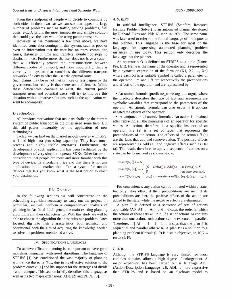
A. STRIPS
In artificial intelligence, STRIPS (Stanford Research
Institute Problem Solver) is an automated planner developed
by Richard Fikes and Nils Nilsson in 1971. The same name
was later used to refer to the formal language of the inputs to
this planner. This language is the base for most of the
languages for expressing automated planning problem
instances in use today. This section only describes the
language, not the planner.
An operator O is defined on STRIPS as a tuple (Name,
Pre, Eff). Name is the name of the operator and is represented
by a syntactic expression of the form or (X1, X2, ..., Xn)
where each Xi is a variable symbol is called a parameter of
the operator. Pre and Eff are respectively the preconditions
and effects of the operator, and are represented by:
• An atomic formula (predicate_name arg1, ... argn), where
the predicate describes the type of fact and arguments are
symbolic variables that correspond to the parameters of the
operator. An atomic formula can also occur if it appears
negated the effects of the operator.
• A conjunction of atomic formulas. An action is obtained
after replacing all the parameters of an operator for specific
values. An action, therefore, is a specific instance of an
operator. Pre (a) is a set of facts that represents the
preconditions of the action. The effects of the action Eff (a)
are the facts that add and remove action. The positive effects
are represented as Add (a), and negative effects such as Del
(a). The result, therefore, to apply a sequence of actions on a
state can be formalized as shown below:
For convenience, any action can be initiated within a state,
but only takes effect if their preconditions are met. If its
preconditions are met, the positive effects of the action are
added to the state, while the negative effects are eliminated.
A plan P is defined as a sequence of sets of actions
applicable (A0, A1, ..., An), and indicates the order in which
the actions of these sets will run. If a set of actions Ai contains
more than one action, such actions can be executed in parallel.
Therefore, if | Ai | = 1 i = 1 ... n says that the plan P is
sequential and parallel otherwise. A plan P is a solution to a
planning problem if result (I, P) is a state objective, ie, if G ⊆
result (I, P).
B. ADL
Although the STRIPS language is very limited for most
complex domains, allows a high degree of enlargement. A
major expansion has been carried out is language ADL
(Action Description Language [2]). ADL is more expressive
than STRIPS and is based on an algebraic model to

International Journal of Artificial Intelligence and Interactive Multimedia, Vol. 1, Nº 2.
- 59 -
characterize the states of the world. The main extensions
added are:
• Types: ADL allows assigning types to objects of the
problem and the parameters of the operators. This facilitates
understanding of problems and reduces the number of
predicates (fact types) needed.
• Preconditions and negated goals: ADL can include negated
atomic formulas in the preconditions of an operator. Similarly,
you can specify negated literals in the goals to represent those
who do not want facts in an objective state.
• Disjunctive Preconditions: ADL allows a precondition can
be a disjunction of atomic formulas.
• quantified preconditions: preconditions may include
quantified formulas, both existential (exists) as universal
(forall).
(forall (? v1 • v2 ...) [formula])
(exists (? v1 • v2 ...) [formula])
• Comparisons: ADL introduces a new type of atomic
formula in the pre-conditions (= arg1 arg2), which is satisfied
when its two arguments are equal. This equality predicate
(called Equality) symbols compares variables within an
operator.
• Effects conditionals in ADL domain, operators can contain
conditional effects (when condition [formula]). Conditional
effects have effect only if specified condition is satisfied in
the state on implementing the action. Conditional effects are
mainly situated in quantified formulas.
These extensions can reduce the number of instantiated
actions, because each action is possible to express a wider
range of situations. You can take this advantage to improve
the efficiency of many planning systems [2].
C. PDDL
ADL has been one of the extensions of STRIPS most used
by planners, but not alone. For example, FStrips (Functional
STRIPS) is a first-order language, without quantification,
working with constants, functions and relational symbols - but
not symbols variables - and increases the expressiveness of
the language. However, the extent of greatest success has
undoubtedly been PDDL (Planning Domain Definition
Language [3]). PDDL was developed for the international
planning competition in 1998 [McDermott 2000] with the aim
of providing a common notation for modeling planning
problems and evaluate the performance of the planners. Since
its inception, PDDL has been a point of reference as modeling
language for the vast majority of planners.
Apart from STRIPS and ADL, PDDL has been influenced
by many other formalisms: SIPE-2, Prodigy 4.0, UCMP,
Unpop and UCPOP [1]. The PDDL goal is to express the
physics of a domain, ie which predicates are, what actions can
be performed and what are its effects, without providing any
additional knowledge about it. PDDL provides a wide variety
of features, among which are:
• Model-based action STRIPS.
• Conditional effects and universal quantification, as
proposed in ADL.
• Specification of hierarchical actions. The actions are
broken down into sub-actions and sub goals that can
contribute to more complex problems.
• Definition of domain axioms. The axioms are logical
formulas that establish relationships between things that are
satisfied in a state (as opposed to equity, which define
relations between successive states).
• Specification of security restrictions. These restrictions
allow to define a set of objectives to be met throughout the
planning process.
Given the large number of features that PDDL can express
virtually any existing planner is able to handle them all.
PDDL brings these features into a set of requirements. In this
way, planners can quickly check if they can handle a
particular domain.
D. PDDL Extensions
One of the main contributions of the competition in 2002 was
planning a new version of PDDL language: v2.1 PDDL [4].
The most important characteristics are incorporating the
ability to define actions with duration and to describe the
effects that time has on stocks. It also modifies the treatment
of numeric expressions and to specify, as part of the problem
itself, an objective function (called metrics) that establishes
the criteria for optimizing the plan.
PDDL v2.1 is organized into the following four levels:
• Level 1: includes propositional and ADL levels of the
previous version of PDDL.
• Level 2: establishing a definitive syntax for handling
numeric expressions. The numerical expressions are
constructed by arithmetic operators and numeric functions.
These functions associate numerical values to tuples of
objects of the problem. The numerical terms the actions are
always comparisons between pairs of numeric expressions,
while the effects can modify the values of numerical
functions.
• Level 3 makes use of discrete durative actions. Thus, it is
possible to indicate the moments during and after the
implementation of an action effect occurs.
• Level 4: Allows durative actions that have continuing
effects. To model this effect, introduce the symbol # t which
represents the continuum over time during the execution of a
durative action.
More recently, a new extension called PDDL+ a fifth level.
This level allows you to model efficiently the occurrence of
events during the execution of a plan. PDDL+ also supports
modeling of business processes that are activities that, while
they last, cause continuous changes in the values of numerical
expressions.

Special Issue on Business Intelligence and Semantic Web. ISSN - 1989-1660
- 60 -
V. CHOICE OF THE SHEDULING ALGORITHM
After analyzing the world of planning in Artificial
Intelligence, the main existing algorithms and the
requirements for carrying out the main project exposed
before, we can reach an important conclusion. The most
appropriate algorithm for our problem is JSHOP2. The
reasons that led us to this choice are detailed below.
The main difference between SHOP2 and most other HTN
planners is that SHOP2 plans tasks in the same order will be
executed knowing the current status of each step of the
planning process. This reduces the reasoning complexity by
removing the large uncertainty degree about the domain and
allows to easily incorporate power of expression to SHOP2.
Besides the common HTN methods and operators, the
description includes SHOP2 domain axioms, mixed symbolic
and numerical conditions and external function calls. The
planning process is complete according to Turing, consistent
and complete for a typology of planning problems.
Like other HTN planning systems, SHOP2 plans
decomposing tasks into subtasks. A key idea in the use of any
HTN planner is to design a set of methods that encode
standard operating procedures catching several passes
techniques for refining a task. Some features of the domain
are expressed in a much more natural in a notation that HTN
in a stock-based notation.
JSHOP2 is SHOP2 Java implementation. From a global
standpoint, it is important to consider the programming
language being used in the project. We have decided to use
J2EE to develop the main solution, so JSHOP2 becomes the
most appropriate algorithm.
VI. SHOP2: SIMPLE HIERARCHICAL ORDERED PLANNER 2
A. Introduction
SHOP2, Simple Hierarchical Ordered Planner 2 [5] is a
domain-independent planning system based on Hierarchical
Task Network (HTN) planning. In the 2002 International
Planning Competition, SHOP2 received one of the top four
awards, one of the two awards for distinguished performance.
This paper describes some of the characteristics of SHOP2
that enabled it to excel in the competition.
Like its predecessor SHOP, SHOP2 generates the steps of
each plan in the same order that those steps will later be
executed, so it knows the current state at each step of the
planning process. This reduces the complexity of reasoning by
eliminating a great deal of uncertainty about the world,
thereby making it easy to incorporate substantial expressive
power into the planning system. Like SHOP, SHOP2 can do
axiomatic inference, mixed symbolic/numeric computations,
and calls to external programs.
SHOP2 also has capabilities that go significantly beyond
those of SHOP:
• SHOP2 allows tasks and subtasks to be partially ordered;
thus plans may interleave subtasks from different tasks. This
often makes it possible to specify domain knowledge in a
more intuitive manner than was possible in SHOP.
• SHOP2 incorporates many features from PDDL, such as
quantifiers and conditional effects.
• If there are alternative ways to satisfy a method‘s
precondition, SHOP2 can sort the alternatives according to a
criterion specified in the definition of the method. This gives a
convenient way for the author of a planning domain to tell
SHOP2 which parts of the search space to explore first. In
principle, such a technique could be used with any planner
that plans forward from the initial state.
• So that SHOP2 can handle temporal planning domains, we
have a way to translate temporal PDDL operators into SHOP2
operators that maintain bookkeeping information for multiple
timelines within the current state. In principle, this technique
could be used with any non-temporal planner that has
sufficient expressive power.
The rest of this paper is organized as follows. Section 2
gives some background on HTN planning, and Section 3
describes SHOP2‘s features and planning algorithm. Section 4
describes how to write domain descriptions for SHOP2: in
particular, Section 4.1 discusses basic problem-solving
strategies, and Sections 4.2 and 4.3 describe aspects of
SHOP2 that are specific to handling temporal and metric
domain features. Section 5 discusses SHOP2‘s performance in
the competition, Section 6 discusses related work, and Section
7 gives a summary and conclusion. Appendix A contains a
SHOP2 domain description for one of the problem domains in
the planning competition.
B. HTN Planning
HTN planning is like classical AI planning in that each
state of the world is represented by a set of atoms, and each
action corresponds to a deterministic state transition.
However, HTN planners differ from classical AI planners in
what they plan for, and how they plan for it.
The objective of an HTN planner is to produce a sequence
of actions that perform some activity or task. The description
of a planning domain includes a set of operators similar to
those of classical planning, and also a set of methods, each of
which is a prescription for how to decompose a task into
subtasks (smaller tasks). Figure below gives a simple
example.
Given a planning domain, the description of a planning
problem will contain an initial state like that of classical
planning—but instead of a goal formula, the problem

International Journal of Artificial Intelligence and Interactive Multimedia, Vol. 1, Nº 2.
- 61 -
specification will contain a partially ordered set of tasks to
accomplish.
Planning proceeds by using the methods to decompose
tasks recursively into smaller and smaller subtasks, until the
planner reaches primitive tasks that can be performed directly
using the planning operators. For each nonprimitive task, the
planner chooses an applicable method, instantiates it to
decompose the task into subtasks, and then chooses and
instantiates methods to decompose the subtasks even further,
as illustrated in figure below.
If the plan later turns out to be infeasible, the planning
system will need to backtrack and try other methods.
HTN methods generally describe the ―standard operating
procedures‖ that one would normally use to perform tasks in
some domain (e.g., see Figure 1) Most HTN practitioners
would argue that such representations are more appropriate
for many real-world domains than are classical planning
operators, as they better characterize the way that users think
about problems.
Like most other HTN planners, SHOP2 is ―hantailorable:‖
its planning engine is domain-independent, but the HTN
methods may be domain-specific, and the planner can be
customized to work in different problem domains by giving it
different sets of HTN methods. The ability to use domain-
specific problem-solving knowledge can dramatically improve
a planner‘s performance, and sometimes make the difference
between solving a problem in exponential time and solving it
in polynomial time. In experimental studies, handtailorable
planners have quickly solved planning problems orders of
magnitude more complicated than those typically solved by
―fully automated‖ planning systems in which the domain-
specific knowledge consists only of the planning operators.
C. JSHOP Characteristics
This section describes SHOP2‘s planning algorithm and some
of SHOP2‘s distinctive features. The Basic Elements of a
Domain Description are:
1) Tasks: A task represents an activity to perform.
Syntactically, a task consists of a task symbol followed
by a list of arguments. A task may be either primitive or
compound. A primitive task is one that is supposed to be
accomplished by a planning operator: the task symbol is
the name of the planning operator to use, and the task‘s
arguments are the parameters for the operator. A
compound task is one that needs to be decomposed into
smaller tasks using a method; any method whose head
unifies with the task symbol and its arguments may
potentially be applicable for decomposing the task. The
details are discussed in the following subsections.
2) Operators: Each operator indicates how a primitive task
can be performed. The operators are very similar to
PDDL operators: each operator o has a head head(o)
consisting of the operator‘s name and a list of parameters,
a precondition expression pre(o) indicating what should
be true in the current state in order for the operator to be
applicable, and a delete list del(o) and add list add(o)
giving the operator‘s negative and positive effects. Like
in PDDL, the preconditions and effects may include
logical connectives and quantifiers. The operators also
can do numeric computations and assignments to local
variables. Just as in PDDL, no two operators can have the
same name; thus for each primitive task, all applicable
actions are instances of the same operator. Each operator
also has an optional cost expression (the default value is
1). This expression can be arbitrarily complicated and can
use any of the variables that appear in the operator‘s head
and precondition. The cost of a plan is the sum of the
costs of the operator instances.
3) Methods: Each method indicates how to decompose a
compound task into a partially ordered set of subtasks,
each of which can be compound or primitive. The
simplest version of a method has three parts: the task for
which the method is to be used, the precondition that the
current state must satisfy in order for the method to be
applicable, and the subtasks that need to be accomplished
in order to accomplish that task.
4) Axioms: The precondition of each method or operator
may include conjunctions, disjunctions, negations,
universal and existential quantifiers, implications,
numerical computations, and external function calls.
Furthermore, axioms can be used to infer preconditions
that are not explicitly asserted in the current state. The
axioms are generalized versions of Horn clauses, written
in a Lisp-like syntax: for example, (:- head tail) says that
head is true if tail is true. The tail of the clause may
contain anything that may appear in the precondition of
an operator or method.
VII. PLANNING TOOLS: JSHOP2
As we said before, planning was conducted using JSHOP2.
JSHOP2, is a planning system based on HTN (Hierarchical
Task Network).

Special Issue on Business Intelligence and Semantic Web. ISSN - 1989-1660
- 62 -
A. JSHOP2: Design and Implementation Details
As specified in previous paragraphs, JSHOP2 is based on
PDDL. However, it does not recognize the PDDL literally.
Therefore, it is used an equivalent PDDL language written in
LISP.
The domain is composed of operators, methods, and
axioms. Domain components (operators, methods, and
axioms) are logical expressions. These logical atoms combine
logical expressions in a variety of forms (conjunctions,
disjunctions, etc.). The atoms incorporated symbols of
predicate logic plus a list of terms. Task lists the problems are
composed of atoms of tasks.[6]
The problem consists of logical atoms (initial state) and a
list of tasks (high-level actions).
B. JSHOP2GUI 1.0.1
Although the JSHOP2 command line is enough to obtain a
planning, it is difficult to analyze the different steps that the
planner performs during the planning process. The Graphical
User Interface (GUI) for JSHOP2 solves this problem by
offering the user a way to analyze the task decomposition tree.
The goal of any GUI is to bring users a fast, easy and
intuitive way to work with a program. In this case, the GUI
allows you to see graphically the steps that planning is
composed of. Its main advantage is that it facilitates analysis
of the results and finds possible errors in the algorithm. [7]
The actions performed by JSHOP2 to achieve a planning
are represented by the GUI as a series of steps. These steps
can be traversed forwards using the corresponding buttons.
The main window of the GUI shows the task decomposition
tree. In the information window shows data on the state of the
world domain and the action undertaken.
The main window of the GUI shows the task
decomposition tree where each node represents a task atom.
The task atoms that appear in the tree are always the initial
stages of the most high that are used to find the current plan.
Nodes can vary in size.
A large node is a visited node, while small ones correspond
to those for which has not been yet visited. Furthermore,
nodes may be of a different color. Yellow indicates a node
that is part of a total order among their brothers. A blue node
indicates a unordered task. If the cursor is on any node of the
tree, and ordered states visited node will be shown in a popup
window.
Leaf nodes have a number surrounded by brackets
preceding the name of the atom of its task. Indicates the
position of the primitive action in the sequence of actions that
create the planning.
Initially it is assumed that each node is a leaf node when it
first reached. If the task represented by that node becomes a
complex task, the number of the sheet is removed from the
task and is decomposed into subtasks.
VIII. PLANIFIC@ PROJECT
So far we have focused on testing the different algorithms
and techniques in the route planning field and optimal paths.
Once you have decided which suites best to the needs
imposed by our project, we will use JSHOP2 based on PDDL.
The application that we want to develop is called Planific@
and will be integrated into a bigger and more ambitious
project called Moviliz@. The project Moviliz@ is a web and
mobile application that guides people through Madrid (Spain)
using the public transport of the city.

International Journal of Artificial Intelligence and Interactive Multimedia, Vol. 1, Nº 2.
- 63 -
All HTN-PDDL project consists of two files. One defines
the domain and the other the problem.
• In Domain file are defined the methods and operators (or
actions) that call the methods.
• In Problem file it could be found objects that are going to
take part in the problem, the initial state of all components, as
well as the objectives.
A. Domain definition
At the beginning of this document we describes the
motivations and features of the project Moviliz@. Now, we
are going to define the elements involved in the design of the
planner and their interdependencies.
The vehicles needed to carry out the project are bus,
subway and on foot.
• Bus. The application will consist of a series of buses and
lines. Each line consists of several buses that cannot get out of
that line. A bus belongs to a single line and a line can have
multiple buses.
• Subway. The application will consist of a series of trains
and lines. Each line consists of several trains that cannot get
out of that line. A train is in a single line and a line can take
several trains.
• Foot. Another option is to travel on foot. A user can
move between two points in the city on foot. In most cases
where we plan a route, the user's point of origin will not
match the bus or subway station near you. It will therefore be
necessary to plan a path to walk to the bus stop. Another
possible option is to get off at any intermediate stops of the
tour, either subway or bus, and walk to another stop to get on
other transportation.
• Lines. The system consists of several lines for different
modes of transport, not for on foot routing. The lines are
finite, they have several stops, and can be circular or not. The
vehicles move along these lines between different stops.
The lines are the sections in charge of merging two stops.
When calculating the ideal route these lines are the key
decision. More than lines, the weights associated with each of
the stages are the key element. You have to mark each section
with weight and a long distance. It will take into account the
buses or trains timetable, as well as the time it takes from the
street to the corresponding platform. This time is really
necessary, especially when making changeovers.
• Stops. A stop is the point where a line is accessed. The
user must get to that station on foot and wait for the
appropriate transport vehicle. Once this vehicle has arrived,
the user must upload this vehicle, the vehicle moves to the
next stop. The operations are equal for both, bus and subway,
so we only need to kind of one type of stop. To determine
whether the stop belongs to subway or bus, we can see the
route through which we reach this stop.
• Interchange. It is possible to change the public transport
in the middle of planning. This feature implies a change of
line. The change can be performed in two ways:
• Change on foot: in any of the stops the user can move
off and walk to a nearby stops if planner decide that.
• Interchange: some of the stops of the model are
matched with other lines. It is in these places where the
user can change the line without needing to shift on foot,
but with a penalty. You have to get out of your current
vehicle and wait for a new one.
B. Problem definition
The problem, as stated in previous paragraphs, is the file
that describes the environment that will be applied to the
Domain. That is, the problem initializes the variables with
which to work and the relationships that exist between
different model components.
It would be necessary to define the graph of the planning
application. Make an association between stops, both subway
and bus, with their respective relationships, indicating the
weights as explained in previous paragraphs. It is necessary to
define the relationship between stops and lines, that is, to tell
which stop belongs to which particular line. This is necessary
because, although we have said that transportation and his
stops behave the same way, we must always know the line the
user is moving on, in order to guide him/her to the destination
correctly.
Having defined the graph on the schedules were
implemented, we must define the elements within it. First we
must define the position of the moving parts. Buses and trains
are in different positions each time so the system has to
behold it. In addition, the start position from which the user
wants to be indicated varies with each plan. The same applies
to the destination position.
IX. DIFFERENT SOLUTIONS
This section sets out a series of practical examples that
demonstrate the operation of simplified models. These models
let analyze the overall operational of the system by a reduced
example that gradually approach the desired solution.
First, the route-planning problem was addressed using
SHOP, particularly JSHOP2. JSHOP2 is a planner that
obtained a certain impact on the 2002 International Planning
Competition because it was able to resolve all problems on the
proposed domains and it got one of four first prizes.
But beyond this fact, JSHOP2 is not widespread and only
exists a few resolved problems running that those which
where proposed in the competition discussed above.
After an arduous research work we accomplished a close
approximation of the problem solution. Two necessary files,
domain and problem, were written in order to calculate how to
get from one point to another using various means of public
transport.
The conduct and outcome of this research is collected on
the research document attached to this article. Despite the

Special Issue on Business Intelligence and Semantic Web. ISSN - 1989-1660
- 64 -
results obtained using JSHOP2 we decided to take a second
track because of the problems that by their very nature caused
us when we tried to integrate the route reached with this
planner into the Web portal and Google Maps Mashup, the
interface from which users will interact with the system.
It was therefore decided to initiate a parallel investigation
to resolve the problem. The other idea was to use Dijkstra's
algorithm for solving the planning, integrate this algorithm
into a web portal created to implement and manage route
planning, and finally integrate these planning results in a
Google Maps Mashup. [8], [9].
Having explained the reason for both approaches, we proceed
to detail them.
A. JSHOP2 Solution
The definition of the problem domain takes place in the file
D_Planifica and comprises methods and operators that specify
the tasks and subtasks to perform even a solution to solve a
planning problem.
Moreover P_Planifica file contains the specific problem to
be solved. In this file were created many problems to solve
that will be discussed below. The methods specify tasks and
subtasks to be performed. A method in turn can contain
several methods to execute if it meets a number of conditions.
These methods are included in other subtasks of the task.
The nesting of methods creates a structure of tasks and
subtasks that concludes with the execution of primitive
operators. These operators, entities of lower levels of
abstraction, are responsible for carrying out actions that will
resolve the problem. The solution to it is precisely the
sequence of all primitive operations are carried out to achieve
the objective.
The methods and operators used to define the problem
domain that also contain all the search logic of routes are
described in the documentation attached to this article.
However, below you could find some figures of the execution
of and example with some transport lines.
B. Dijkstra – Google Maps Solution
As it was said at the beginning of this section, with the first
approach did not obtain the expected results. This is the
reason for what we decided to tackle the problem from
another point of view. Not the best way to deal with solving a
complex problem, as are all combinations of public
transportation services at Madrid, but it does provide a good
approximation of what would be the end result.
• Dijkstra. Dijkstra algorithm is implemented in J2EE,
it is integrated into a web portal and the results are
displayed in the Google Maps Mashup that is integrated
into the web portal.
Dijkstra's algorithm, conceived by Dutch computer scientist
Edsger Dijkstra in 1959, is a graph search algorithm that
solves the single-source shortest path problem for a graph
with nonnegative edge path costs, producing a shortest path
tree. This algorithm is often used in routing. An equivalent
algorithm was developed by Edward F. Moore in 1957.
For a given source vertex (node) in the graph, the algorithm
finds the path with lowest cost (i.e. the shortest path) between
that vertex and every other vertex.
It can also be used for finding costs of shortest paths from
a single vertex to a single destination vertex by stopping the
algorithm once the shortest path to the destination vertex has
been determined. For example, if the vertices of the graph
represent cities and edge path costs represent driving distances
between pairs of cities connected by a direct road, Dijkstra's
algorithm can be used to find the shortest route between one
city and all other cities. As a result, the shortest path first is
widely used in network routing protocols, most notably IS-IS
and OSPF (Open Shortest Path First). [8]

International Journal of Artificial Intelligence and Interactive Multimedia, Vol. 1, Nº 2.
- 65 -
• Google Maps. The Google Maps API allows you to
embed Google Maps in your own web pages with
JavaScript. The API provides several utilities for
manipulating maps and adding content to the map using
various services, allowing you to create robust maps
applications on your site.
Google Maps is a GIS application by Internet company
Google, which its potential for this type of project is very
high. Therefore, we have decided to show route planning
performed by Dijkstra's algorithm using this API.
Moreover, this application will be integrated into a web
portal as a Mashup. [9]
The possibilities offered by the Google Maps API are
many, but not being the main objective of this work we
will not deepen them. However, if you want to do more
research on the subject, this link may be helpful:
http://code.google.com/intl/es-ES/apis/maps/
• Planific@. In order to simplify the comprehension of the
whole project we are going to limit the public transport of
Madrid to the following graph.
The same graph in a schematic way will be as follow:
More details about implementation and web portal integration
could be found at the attached document. However, below
you could find some images of the final solution.
General map view
General Satellite view
Planning view

Special Issue on Business Intelligence and Semantic Web. ISSN - 1989-1660
- 66 -
X. CONCLUSION
This paper shows the investigation study carried out about the
different ways to perform route planning. After searching all
possible solutions to resolve this problem we could say that
HTN-PDDL and JSHOP2 is apparently the best way to reach
the objective proposed based on the studied algorithms. So we
started to design the PDDL domain that represented the
proposed problem and it was seemingly easy and powerful.
However, it has to be noted that in PDDL there is a clear
distinction between the description of parameterized actions
that characterize the behavior of the domain and descriptions
of specific objects, initial conditions and goals that
characterize a particular problem. While, PDDL domain
description is robust enough to model the behavior, we think
that language has certain shortcomings when is needed to
express the initial state and the objectives to be achieved in
certain types of problems, for example, PDDL is unable to
indicate a multiple initial state that allows not only minimize
the objective function.
Moreover the language is not flexible when it necessary to
instantiate the predicates and functions describing the initial
state of a problem, which is quite tedious and impractical,
especially when defining the problems as our case in which
initialization involves a large number of nodes. It would be
appreciate a reference to instances of more generic predicate
to avoid having to make an exhaustive list. As for the tool
used, JSHOP2, worth mentioning that the abstraction in which
we must write the file and problem domain is based on LISP.
This implies that clarity offered by PDDL defining operators,
methods and designing the problem is lost, making more
complicated to design the solution. We cannot fail to mention
the great help that involved the use of graphical user interface
used, JSHOP2GUI 1.0.1, which allowed us to do a larger
number of tests because of its ease of use and the ease of
debugging code.
Another problem with JSHOP2 was the great difficulty that
we found to integrate the route reached with this planner into
the Web portal and Google Maps Mashup, the interface from
which users will interact with the system. After seeing all this
difficulties that we find in this approximation to the solution,
we tried a second via to solve the problem. We think that the
best way to accomplish this is by using the Dijkstra algorithm
written in J2EE, the same platform used for the web portal. It
was easier to integrate the planning results with the Google
Maps Mashup and these results were efficient and accurate
enough.
As a final conclusion, we would like to say that throughout
this investigation we have noticed that PDDL is a very
powerful tool in order to write planning domains, but there is
no planner that use it directly, transferring the domain
information in the same language. We think that it would be
very interesting to research on planners that use all the
capacity that it owns. JSHOP2 is an ambitious academic
project with great potential, but nowadays it is quite difficult
to solve a problem that demands some complexity with this
planner.
REFERENCES
[1] Okhtay Ilghami; Dana S. Nau.. A general approach to synthesize
problem- specific planners. Technical Report CS-TR-4597, Department
of Computer Science, University of Maryland. USA. Oct 2003.
[2] Dana S. Nau; Muñoz-Avila, Héctor; Cao, Y; Lotem, A; and S. Mitchell. Aug 2001. ―Total-order planning with partially ordered subtasks‖. In
Proceedings of the Seventeenth International Joint Conference on
Artificial Intel ligence, Seattle, WA, August 2001. [3] Nau, Dana. "Simple Hierarchical Ordered Planner. SHOP Automated
Planning.‖ . University of Maryland. USA. 17 Feb 2005 [Online].
Available: http://www.cs.umd.edu/projects/shop/ [4] D. Nau, T.-C; Au, O; Ilghami, U; Kuter, J. W; Murdock, D; Wu, and F;
Yaman. ―SHOP2: An HTN planning system. Journal of Artificial
Intelligence Research‖. Dec 2003. [5] D. S. Nau, Y. Cao, A. Lotem, and H. Muñoz-Avila. ―SHOP: Simple
hierarchical ordered planner‖. Proceedings of the International Joint
Conference on Artificial Intelligence (IJCAI), Morgan Kaufmann Publishers. 06 Aug 1999.
[6] Ilghami, Okhtay. "Documentation for JSHOP2". 24 Aug 2009. [Online].
Available: http:/ourceforge.net/projects/shop
[7] Shin, J. ―A Graphical Interface for JSHOP2‖. Department of Computer
Science University of Maryland, College Pak. Jun 2006
[8] Wikipedia. ―Dijkstra Algorithm‖. Aug 2009. [Online]. Available: http://en.wikipedia.org/wiki/Dijkstra's_algorithm
[9] Google Map. ―Google Maps API‖. Aug 2009 [Online]. Available:
http://code.google.com/intl/en/apis/maps/
C. Martín García, Madrid, 1984, 5th Year Computing Engineering Student
at Universidad Pontificia de Salamanca, Madrid, Spain. e-mail:
G. Martín Ortega, Madrid, 1982, 5th Year Computing Engineering Student
at Universidad Pontificia de Salamanca, Madrid, Spain. e-mail: