rr/2004/3496/p - residents - rother district council · web viewrr/2004/3650/p mountfield 10...
TRANSCRIPT

RR/2004/3496/P ASHBURNHAM CLAYS FARM, BROWNBREAD STREETOUTLINE: ERECTION OF EDUCATION/INTERPRETATION CENTRE TOGETHER WITH ERECTION OF THREE CHALETS TO PROVIDE ASSOCIATED ACCOMMODATION.D Steains and A Smith in conjunction with Brownbread Horse Rescue
Statutory 8 week date: 01 February 2005
SITE Clays Farm lies on the west side of Brownbread Street and is the home of the Brownbread Horse Rescue Centre.
HISTORY (Relevant)RR/79/1058 Use of land and buildings as riding school in addition to present
use namely breeding and training of horses - Approved Conditional.
RR/88/356 Hay barn - Refused.RR/98/1633/P Replacement barn - Refused.RR/1999/844/P Replacement barn for storage and handling of feedstuffs, secure
machinery storage and in-wintering - Refused - Appeal Allowed.RR/2000/1029/O Lawful stationing of caravan for residential purposes - Approved.
PROPOSAL Outline planning permission is sought for the construction of three chalets for occupation from March to October each year by visitors and the erection of a building to be used as an education/interpretation facility. Accompanying the application is a supporting statement that is attached to this statement as an APPENDIX DOCUMENT relating to this Committee 20 January 2005. Additionally, an illustrative plan indicates the interpretation centre building measuring 20m by 10m sited close to the present cluster of buildings. The chalets are indicated further to the west approximately 200m from the highway.
CONSULTATIONSParish Council:- Considers the application should be a full application not an outline because a change of use is proposed. Notwithstanding this the Council is opposed to the proposal on the grounds: i) unjustified residential development in the countryside contrary to HG10 and GD1; ii) development should be carefully controlled in the AONB (Structure Plan EN2, Local Plan GD1); iii) inadequate car parking (GD1); iv) impact of additional traffic on landscape, free flow of traffic and residential amenity (EN3, CF5 and GD1).Highway Authority:- Comments awaited.Environment Agency:- No objections - conditions requested.Southern Water:- Does not wish to comment on the application.Environmental Health:- No objection but recommends the imposition of a contaminated land condition.Planning Notice:- No representations received.
SUMMARY The site is within the High Weald Area of Outstanding Natural Beauty and notwithstanding that the site is operated as a charity staffed mainly by volunteers the proposal must be considered under the same policies as any commercial proposal in the countryside.Policy DS1(vi) requires that the character of the AONB is not prejudiced, DS2(vi) states that the Council will “continue to generally restrict new development in the countryside,
1

including resisting the intensification of sporadic development and existing smaller settlements, for which there is no development boundary, whilst promoting sustainable land based industries and sensitive diversification, primarily for employment uses.”The site is not within a development framework and therefore under the terms of policy DS4 it is therefore necessary to demonstrate that a countryside location is necessary. In this regard the proposal needs to be divided into the two separate component parts. In my view the provision of the three chalets is not justified. It may be convenient for visitors to be accommodated on site but I can see no necessity whatsoever.The proposed education/interpretation centre is allied to the present use of the land and needs to be considered against policies DS1 and GD1. The proposed building is large (20m by 10m) and the indication is that because a mezzanine floor is indicated it would be the height of a two storey building. I am for this reason concerned about the potential landscape impact upon the AONB. Moreover, it must be assumed that the provision of such a facility is likely to result in additional traffic movements and requirement for on-site parking. It is reasonable to expect that the applicants see the proposal as an expansion of the operations on site and that such a building would be fully utilised and promoted. The consultation response from the Highway Authority is awaited.
RECOMMENDATION: REFUSE (OUTLINE PLANNING)1. The site lies within the High Weald Area of Outstanding Natural Beauty, where
policies S1(j), EN1, EN2 and EN3 of the East Sussex and Brighton & Hove Structure Plan 1991-2011 and Policies DS1(vi) and GD1(v) of the Rother District Local Plan: Revised Deposit (November 2003) indicate that development will be carefully controlled to protect the character of the area. It is considered that the proposal does not meet this objective, and it would cause harm to the rural character of the area.
2. The site is within the countryside, outside the Development Boundary of any town or village, where Policy S10 of the East Sussex and Brighton & Hove Structure Plan 1991-2011 and Policies GD1 and HG10 of the Rother District Local Plan: Revised Deposit (November 2003) indicate that development will only be permitted if a countryside location is necessary. The necessity of this development has not been established to the satisfaction of the Local Planning Authority and the development proposed is considered to be contrary to these policies.
3. It is considered that the proposed development would be out of character with the High Weald Area of Outstanding Natural Beauty and would give rise to additional traffic problems in the area contrary to Policy CF5 of the Rother District Local Plan: Revised Deposit (November 2003).
4. Highway reason as may be recommended by the Highway Authority.
RR/2004/3579/P CATSFIELD WYLANDS INTERNATIONAL ANGLING CENTRE, POWDERMILL LANEOUTLINE: ERECTION OF DWELLING HOUSE FOR MANAGERMr D Bull
Statutory 8 week date: 28 Jan 2005
SITE Wylands Angling Centre on the south side of Powdermill Lane extends to some 62 hectares (154 acres).
2

HISTORY (Relevant)RR/80/511 O/A Pair of semi-detached agricultural dwellings – Approved
conditionalRR/88/2966 O/A Two detached agricultural dwellings – WithdrawnRR/90/2305 O/A Two detached dwellings to replace existing cottages –
Refused – Appeal dismissedRR/91/2136/P O/A 2 detached dwellings and retention of existing cottages for
use as holding cottages – Refusal – Appeal dismissedRR/93/2135/P O/A Erection of detached dwelling – Refusal – Appeal dismissedRR/93/2145/P Conversion of two cottages into one dwelling – Approved
conditionalRR/98/2292/P O/A Erection of 15 fishermans cabins, facilities building,
workshop/store new dwelling and conversion of two existing dwellings into one, also re-siting if access – Appeal conditional
PROPOSAL This outline application is for the erection of a detached dwelling house for occupation by a manager. The proposed siting is to the north west of the existing dwelling overlooking the lake known as House Lake.
CONSULTATIONSParish Council – Comments awaited.Highway Authority – Comments awaited.Forestry Commission – Advises that it is Government policy that there should be a presumption that the area of ancient woodland should not be reduced as a result of developmentPlanning Notice – Letter received from Catsfield Manor attached to this report as an APPENDIX DOCUMENT.
SUMMARY Some members will recall the planning application reference RR/98/2292/P that was eventually approved in August 2003 following the completion of a Section 106 Agreement. The 1998 application included a new detached house and the 106 Agreement tied both new and existing dwellings to the holding. This permission has not been implemented and hence the legal agreement has not come into affect. The new owner of the site the current applicant has his own ideas for the whole site and the application the subject of this report forms part of those overall plans. In summary the applicant seeks the dwelling for occupation by a manager and is prepared to restrict the occupation of the new dwelling and to tie it to the core of the holding by 106 Agreement. The existing former pair of cottages, now occupied as a single dwelling would be retained but not tied or restricted. The applicants agent suggest that because there were two dwellings neither of which were tied or restricted they should not now be tied or restricted when occupied as a single dwelling. I cannot accept this approach.It is confirmed within this application that the former pair of cottages are now occupied as a single dwelling, this was approved under reference RR/93/2145/P. Planning permission is required to revert to two units and there is no automatic right to do so. A completely separate detached dwelling in the countryside needs to be justified ie. that a dwelling in addition to the existing is warranted because of the demands of the uses/activities on the site. It has been accepted in the past that this business did require two dwellings, no doubt aided by the fact that there were two dwellings historically. But it was considered essential that both be restricted in their occupancy and tied to the holding. Without this safeguard one could be sold and hence a case made for a further dwelling. Moreover, if it is the case that two dwellings are justified by
3

the activities on the whole site, or at least all of the lakes and visitor accommodation/caravans/tents, they need to be tied to all of the land encompassing those elements. The limited area offered to be tied to the new dwelling only includes the existing and proposed holiday cabins and the existing agricultural buildings and office; none of the lakes would be included.In approving the 1998 applications the site was considered as a whole and the package of proposals balanced against safeguards and benefits achievable and secured by a legal agreement. In my view the current proposal is unacceptable. If two detached houses are justified they should both be tied to the bulk of the site to include all of the facilities that contributed to the justification in the first place.
RECOMMENDATION: REFUSE (OUTLINE PLANNING)1. Policy S10 of the East Sussex and Brighton & Hove Structure Plan 1991-2011
and Policy HG10 of the Rother District Local Plan: Revised Deposit (November 2003) require that it be demonstrated that any new dwelling in the countryside is essential for the running of an enterprise which must be in a rural location. It is accepted by the Council that a second dwelling is justified in relation to all of the activities occurring at Wylands International Angling Centre but without appropriate legal safeguards being put in place to bind the dwellings to the enterprise the properties could be disposed of separately there from. It has not been demonstrated that a second dwelling is essential in connection with the enterprise to which the applicant has expressed willingness to tie the property. An additional unjustified dwelling within the High Weald Area of Outstanding Natural Beauty would be contrary to Policies S1(j), EN2 and EN3 of the East Sussex and Brighton & Hove Structure Plan 1991-2011 and Policy GD1(v) of the Rother District Local Plan: Revised Deposit (November 2003).
RR/2004/3016/P BURWASH ADMIRAL HOUSE, THE SQUARECHANGE OF USE AND CONVERSION OF ADJACENT COACH HOUSE INTO A STUDIO/ANNEXEMr and Mrs M Wyatt
Statutory 8 week date: 17 December 2004
RR/2004/3020/L BURWASH ADMIRAL HOUSE, THE SQUARECONVERSION OF EXISTING ADJACENT COACH HOUSE INTO A STUDIO/ANNEXEMr and Mrs M Wyatt
Statutory 8 week date: 03 December 2004
SITE This property is the former Admiral Vernon Public House on the south side of the High Street at the eastern entrance to the village; the property is now a dwelling house.
HISTORY (Relevant)RR/97/6/P C/U and conversion to dwelling - Approved Conditional.RR/97/7/P Alterations in connection with conversion to a dwelling - LBC
Granted.RR/2002/2471/P Erection of picket fence less than 1m high - Approved Conditional.
4

PROPOSAL It is proposed to convert the detached former coach house, sited to the east of the property, into a studio/annexe. The accommodation would comprise a living room with kitchenette, bathroom/WC and a bedroom within the roof space.
CONSULTATIONSParish Council:- Support approval.Highway Authority:- Recommends that consent be refused. “The existing access at its junction with the A265 has substandard visibility and the existing hazard would be increased by the additional slowing, stopping, turning and reversing traffic which would be created.”County Archaeologist:- No archaeological condition thought to be necessary.Planning Notice:- 2 letters of objections (The Old Police House and the CPRE): i) the building is listed and in Conservation Area; ii) the alterations would alter the appearance of the building; iii) the proposal generates increased car usage; iv) the additional vehicle use will increase pressure on car park opposite which is already overflowing; v) detrimental to setting of listed building and Conservation Area; vi) proposal fails to preserve or enhance the Conservation Area; vii) fails to enhance AONB; viii) additional vehicle movements at a dangerous corner.
SUMMARY The Coach House is a curtilage listed building within the Conservation Area and the development boundary.The applicant has confirmed that the accommodation is required for family purposes; a Section 106 Agreement would prevent its separate occupation and disposal. This I believe would be an appropriate approach.The details of the proposed conversion utilise existing window/door openings with the exception of one new small window within the gable end. All joinery would be of painted timber construction. I do not believe that the alterations to the building would be such as to conclude that the proposal would have an unacceptable effect upon the setting/character of the listed building or the Conservation Area.In regard to the Highway Authority’s response there is in fact sufficient off-road parking to meet your standard for a dwelling (2 spaces) with space to turn and leave the site in forward gear. There is no requirement to provide additional parking for a residential annexe/studio. Indeed, with care more than 2 vehicles can be parked off road.
RECOMMENDATIONS:RR/2004/3016/P: GRANT (FULL PLANNING) DELEGATED (SECTION 106 AGREEMENT)1. The proposed new window frames and doors shall be painted timber
construction only.(Reason: RC4)
2. CN5E (Restriction of alterations/additions).3. The accommodation hereby permitted shall only be used for residential
accommodation in associating with the existing dwelling Admiral House and shall not be used as a separate dwelling unit or business premises.(Reason: RC35).
4. CN7I (Matching alteration materials).
RFG: Policy S1 of the East Sussex and Brighton & Hove Structure Plan 1991-2011 and Policy GD1 of the Rother District Local Plan: Revised Deposit (November 2003).
RR/2004/3020/L: GRANT (LISTED BUILDING CONSENT)
5

1. The proposed new window frames and doors shall be painted timber construction only.(Reason: RC4)
2. CN7I (Matching alteration materials).
RFG: Policy S1 of the East Sussex and Brighton & Hove Structure Plan 1991-2011 and Policy GD1 of the Rother District Local Plan: Revised Deposit (November 2003).
RR/2004/3650/P MOUNTFIELD 10 MOUNTFIELD VILLAS, SOLOMONS LANEVARIATION OF CONDITION 3 OF RR/2004/1148/P TO ALLOW USE OF GROUND FLOOR OF EXTENSION AS A BAKERYMr and Mrs R Hayler
Statutory 8 week date:date: 9 February 2005
SITE 10 Mountfield Villas is a semi-detached property located to the Northern side of Solomons Lane, within the High Weald AONB.
HISTORYRR/2004/1148/P Erection of two storey extension to the side – Approved
Conditional.
PROPOSAL Planning permission was granted earlier this year for a two storey extension to the side of this property. Condition 3 of the planning consent stipulated that ‘the building shall be used only for purposes incidental to the occupation and enjoyment of the dwelling as such, and not for any trade or business’; this planning application seeks to retain this extension without complying with this condition imposed on consent RR/2004/1148/P. This would allow the use of the ground floor of the extension as a bakery.
CONSULTATIONSParish Council: Comments awaited.Highway Authority: Comments awaited.Director of Services – Environmental Health: Comments awaited.Planning Notice: No representations received.
SUMMARY This application seeks to vary condition 3 of consent RR/2004/1148/P to allow the use of the ground floor of the extension as a bakery. The approved two storey side extension is currently under construction and as such the ground floor element is completed. Prior to this application the applicant had been using the adjacent garage for the last year to bake cakes ‘for supply to about 20 farm shops in the area’. The Agent notes that during this time there has been no conflict with adjoining residential property. There is one delivery of cooking supplies a week and the applicant delivers orders via small transit van 4 times a week, it is proposed to operate the use as a bakery on week days only. The Agent has highlighted that this is a relatively ‘small scale activity’……’ aligned with advice in PPS7, which provides that planning authorities should support countryside-based enterprises and activities which contribute to rural economies’. In this instance, the proposed use appears to be relatively self contained,
6

with minimal disturbance to the amenities of neighbouring properties, although comments from Environmental Health are still awaited in respect of this. There are relatively few transport movements associated with the bakery. The use would require no external material changes to the two storey extension approved under RR/2004/1148/P. I feel able to support this application subject to satisfactory comments from Environmental Health and the Highway Authority. A temporary and personal consent is appropriate for the Local Planning Authority to assess the impact and control the use.
RECOMMENDATION: GRANT (FULL PLANNING) DELEGATED (SUBJECT TO SATISFACTORY COMMENTS FROM ENVIRONMENTAL HEALTH AND HIGHWAY AUTHORITY)1. CN14D. The use hereby permitted shall be carried out only by Mr and Mrs
Hayler.Reason: To enable the Local Planning Authority to regulate and control the development of the land.
2. The use of the ground floor extension as a bakery shall cease and the extension returned to its domestic use as approved under RR/2004/1148/P on or before 09 February 2008.Reason: To enable the Local Planning Authority to regulate and control the development of the land.
3. As recommended by Director of Services – Environmental Health.4. As recommended by Highway Authority.
RFG: Policy S1 of the East Sussex and Brighton & Hove Structure Plan 1991-2011 and Policy GD1 of the Rother District Local Plan: Revised Deposit (November 2003).
RR/2004/2005/P BATTLE 64 HIGH STREETREVISIONS TO PREVIOUS APPROVAL RR/2003/263/P FOR EXTRACTOR FLUE/HOUSING FILTERG & J Bush
Statutory 8 week date: 01 October 2004
This application was deferred at your last meeting following concern expressed by Environmental Health that noise from the extractor system was audible within 64A High Street.
SITE This property is on the north east side of the High Street adjacent to the twitten leading to the Mount Street car park. The building is within the Conservation Area but not listed. The application relates to the ground floor restaurant.
HISTORY (Relevant)RR/2003/263/P C/U from greengrocers to A3 restaurant including installation of
fume extraction duct - Approved Conditional
PROPOSAL The application seeks the retention of the extraction system; the most recently provided plan indicates an amended enclosure intended to imitate more closely a traditional chimney stack. The revised enclosure would be white painted render with a tiled verge and surmounted by a chimney pot.
7

CONSULTATIONSTown Council:- No comment.Director of Services - Environmental Health:- “A noise report has been received with regard to the assessment of noise from the kitchen air extraction fan and flue at the above premises. The report details that the noise is audible within the adjoining residential premises of 64A High Street and appeared to be mainly structure-borne noise, albeit this was witnessed within the non-habitable rooms only i.e. the entrance stairs, kitchen and lobby to habitable rooms.Condition 6 of RR/2003/263/P states that ‘No noise and/or vibration emitted by the ventilation extract system shall be detectable within any adjoining (including 64A High Street) properties’. Therefore on the basis of this report, this condition is not being complied with.”Planning Notice:- No representations received at the time of preparing this report. However, Members will be aware that the flue in question was the subject of Enforcement Action resulting from complaints received concerning its appearance, smells and noise generation.
SUMMARY Members will be aware that in granting planning permission for the change of use of the premises to a restaurant (RR/2003/263/P) care was taken to achieve an enclosed extraction system having the appearance of a chimney. Conditions were also imposed requiring the submission of details of the proposed system and the sound proofing thereof.The planning conditions were not complied with and the ‘chimney’ is not in accord with the approved plan.An Enforcement Notice appeal has now been dismissed.When the system was installed and brought into use complaints were received in respect of its appearance and from noise and odours. The applicant provided a report prepared by an acoustic consultant upon which Environmental Health concluded that since noise could be detected within the flat above it would be desirable, if the occupier consented, to take noise readings within. However, since then the current occupier has written and confirmed that she suffers no noise or odour problems from the system installed. This confirmation, together with the fact that the applicant’s report only identified any noise discernable within the entrance stairs, lobby and kitchen and not within habitable rooms, leads me to take the view that to withhold planning permission on these grounds would be difficult to justify. Particularly since the report confirmed that the only habitable room at the rear of the flat (living room), even with a window open, suffered no audible noise. I am discussing this further with Environmental Health.I would expect to be able to negotiate a suitably detailed revised plan with the applicant’s agent and I hope to be in a position at your meeting to make the
RECOMMENDATION: GRANT (FULL PLANNING)1. Within three months of the date of this planning permission the flue installation
shall be altered in accord with the plans and details hereby approved.Reason: RC14
RFG: Policy S1 of the East Sussex and Brighton & Hove Structure Plan 1991-2011 and Policy GD1 of the Rother District Local Plan: Revised Deposit (November 2003).
8

RR/2004/2613/P BATTLE CLAVERHAM COMMUNITY COLLEGE – LAND AT,NORTH TRADE ROADOUTLINE: ERECTION OF NEW COLLEGE BUILDING AND ALL WEATHER PITCH (WITHOUT FLOODLIGHTING) WITH CONSTRUCTION OF NEW ROAD AND PROVISION OF 33 PARKING SPACESLearning Skills Council Sussex
Statutory 13 week date: 08 December 2004
This application was deferred at your last meeting. Members will recall that I received the requested traffic impact assessment and travel plans two days before your lat meeting; this has now been sent to the Highway Authority for comment. The other outstanding items requiring a response are:-
i) clarification of which sites were considered for the College and why was it concluded that Claverham was the most appropriate;
ii) the revision of the siting of the building and the consideration of additional/resiting of car parking;
iii) consideration of the loss of playing field and information regarding the total available provision at Claverham;
iv) whether a circulatory traffic system is a practical alternative;v) is it possible to outline the longer term plans for Claverham and how the current
proposal dovetails with these plans.
I do not expect these matters to be fully addressed in time for detailed consideration at the January meeting. For ease of reference my previous report, updated, is reproduced below.
SITE The application is the whole College grounds on the south side of North Trade road. The proposed new building would be to the south of the existing buildings on the playing field.
HISTORYWhilst there is an extensive planning history relating to the site as a whole none is directly relevant to this ‘stand alone’ proposal.
PROPOSAL This is an outline application for the construction of a new College and all weather sports pitch; the building also includes a new nursery. However, notwithstanding that the applicant seeks outline planning permission details of siting, design, means of access and external appearance have been submitted for consideration; only landscaping is reserved.The building has a curved plan form roughly 90m by 20m overall with accommodation arranged on 3 floors, access is to the first floor level via a bridge spanning the change of level between the existing college level and that of the playing field.The shell of the building is specified on the plans as grey blockwork, glazed curtain walling to the south, terracotta cladding and Eternit Lamina cladding panels all under a terne coated stainless steel mono pitched roof. Confusingly, the application forms give the walls as brick and tile under a zinc coated aluminium roof.Car parking for 33 vehicles, plus bicycles, is indicated at the lower field level served from the access drive from the eastern access to North Trade Road.The all weather sports pitch would be to the south/south west of the new building.
9

CONSULTATIONSTown Council:- “The Council is strongly opposed to this proposal for a number of reasons. First and foremost the absence of adequate local public transport inevitably means that there would be additional traffic, which would exacerbate existing congestion problems, which regularly reach ‘gridlock’ proportions. Even if this were not the case the Council feels that the proposed provision for car parking on the site is totally adequate. In terms of the building itself the Council feels that it is too big for the site and would be very prominent both in the landscape and in relation to nearby domestic dwellings. Finally, the Council would regret any proposal which would reduce the availability of sporting facilities.”Highway Authority:- Does not wish to restrict the grant of consent subject to the comment:“The Highway Authority is concerned that the provision of car parking may not fall within the limits as set out in the supplementary Planning Guidance Parking Standards. However, this can be agreed at the detail stage once the numbers of staff both teaching and non-teaching have been established.”Environment Agency:- No objection or comment.Southern Water:- No objection but any consent shall be conditional upon the submission of foul and surface water details.East Sussex County Council - Director of Education:- Supports the proposal - forms an integral part of the Authority’s strategy for East Sussex.Sussex Police:- “This site suffers from trespass and damage caused by youths skateboarding on low walls. The new building has an extensive covered area that will be attractive for youths to gather out of school hours. Careful thought should be given to this.”Sport England:- Wish to register an objection to the proposal.i) The two senior football pitches would be lostii) The cricket square and mini hockey pitches would be lostiii) The all weather pitch is not floodlit thereby reducing its community benefitiv) No justification is made for the loss of pitchesv) Sport England’s policy is to oppose any proposal that would result in loss of all or
part of a playing field.East Sussex County Council Planning:- To inform Rother District Council that:-“The principle of this proposal is welcomed and supported. It will help realise an identified need for improved post 16 education facilities in the Battle area, which cannot be met on Brownfield or within the urban area.However, as proposed, the development would have an adverse impact on the High Weald Area of Outstanding Natural Beauty landscape contrary to Structure Plan Policy EN2. To achieve an acceptable scheme the new building should be repositioned further into the north east corner of the plateau to better relate to the existing buildings on the site. This would necessitate relocating the car parking, ideally further north onto the upper level of the site.In addition, before any planning permission is granted the following should be agreed:i) an appropriate landscaping scheme and suitable building materials that mitigates
the impact of the proposal on and respects its setting within the wider Area of Outstanding Natural Beauty landscape (Policy EN2);
ii) appropriate traffic and parking arrangements including the preparation of a Travel Plan for the whole site to the satisfaction of the Highways Authority (Policy TR3); and
iii) measures to minimise and reuse construction waste on site (Waste Local Plan Policy WLP11).”
10

Planning Notice:- 23 letters of objection and a petition of 146 signatories(i) There is already a serious problem with cars parking in surrounding roads, the
proposal will make this worse(ii) There is serious congestion on North Trade Road at school start and finishing
times, the proposal will make this worse(iii) There is insufficient on site parking for all staff and the college students that have
their own car/motor cycle(iv) Considerable additional vehicle movements close to Claverham Way properties
will be an additional noise nuisance(v) The proposed boiler chimney will be a polluting concern particularly to
asthmatics(vi) This is the wrong site, the traffic situation has reached saturation point(vii) If permitted North Trade Road should be 20 mph at start and leaving times. The
side roads will need parking restrictions(viii) Congestion of local roads will restrict access for emergency and service vehicles(ix) Private driveways are blocked by parked vehicles and grass verges are
damaged(x) Members should visit the surrounding residential areas at school and to see for
themselves(xi) Pupils trespass, cause litter, graffiti and vandalism and are abusive to residents;
fireworks and eggs have been thrown at private property. More students will increase the problem
(xii) An all weather pitch is not accepted by the East Sussex League or the Sussex County Football Association - local teams will therefore have no pitch to play on
(xiii) Proposal will be overbearing with loss of privacy and quality of life(xiv) Loss of sports facilities(xv) Contrary to Local Plan - The siting of such a facility should be considered in the
context of Local Plan procedures(xvi) Local residents have been more than tolerant of the expansion of the existing
school but the proposal is an expansion too far(xvii) A site nearer the station would be preferable given the proposed enlarged
catchment area(xviii) The County Council have not produced a transport plan(xix) Scale of building is intrusive in landscape and neighbouring property(xx) The design is unacceptable for historic Battle(xxi) Loss of trees(xxii) The proposed earth mound will attract youngsters, their litter and damage the
enjoyment of adjacent gardens(xxiii) How long will it be before floodlights are wanted or temporary/moveable ones
used?
SUMMARY It should be first stated that the proposed building falls outside of the development boundary for the town set out in the Rother Local Plan; it therefore follows that if you are minded to grant planning permission the application would have to be referred to GOSE as a departure from the Development Plan.Clearly the single issue that comes immediately to mind is that of transport/parking, virtually every local resident that has written refers to the existing problems being experienced. Given the obvious congestion at the start and finish of the school day I requested that the submission be accompanied by a transport assessment. This has not been provided; I am very surprised that the Highway Authority have simply stated that they do not wish to restrict the grant of consent. I believe that this issue needs to be fully addressed in the context of PPG13, your policies TR2 and TR3 and Structure
11

Plan policies. Until this has been undertaken the site specific issues are secondary. I accept that operationally there are obvious benefits in the site proposed but the wider public effects needs to be considered by this Authority. For this and sustainability reasons I consider a transport assessment/travel plan to be essential.The application is accompanied by a landscape appraisal that I accept demonstrates that the impact in the wider landscape is satisfactory. That is not so in the immediate setting. The nearest dwellings are bungalows in Claverham Way, the nearest of which is only 50m away. The bungalows lie at a level below the site upon which the 3 storey building is proposed. An earth mound and tree planting is proposed as mitigation. I am not convinced that the impact of a development of the scale proposed can be made acceptable by this means.Car parking is proposed by the provision of 33 spaces; there is no evidence to support this level of provision particularly when there appears to be an existing parking problem for the existing school staff etc. I am mindful also that a new nursery is proposed. This is likely to result in parents driving to the building to deposit and collect young children at various times of the day. If the spaces provided are for college staff where will these visitors park? The needs of the whole school site need to be assessed, hence my view that further information is needed in respect of transport/servicing/parking matters.I am reluctant to become deeply involved in the consideration of detailed development specific matters until the context of the traffic issue has been addressed and Members have inspected the site. I would however say that I am not opposed to the design concept; I have asked the applicant’s agent to clarify the materials proposed. I have also requested a response to the Sports Council’s fundamental objection to the loss of sports facilities. Although this is an outline application the submission of a levels survey would have been useful to fully assess the overall impact of the proposed development in relation to adjoining properties.
RECOMMENDATION: DEFER (FURTHER INFORMATION)
RR/2004/3288/P BATTLE 9 BATTLE GATES, NORTH TRADE ROADCONVERSION OF EXISTING GARAGE AND EXTENSION OF SAME TO FORM UTILITY AND STUDY AND BEDROOM WITH EXTENSIONS TO THE DORMERS ON THE FRONT AND REARMr B Boswell
Statutory 8 week date: 31 December 2004
SITE This is a detached dwelling located on the east side of this estate. The site is within the Battle development framework, and within the AONB.
HISTORYRR/2003/2324/P Conversion of existing garage and extension of the same to form
utility and study and additional bedroom with extension to dormer to rear. Refused
RR/2004/475/P Conversion of existing garage and erection of extension of the same to form utility and study and additional bedroom with extension to dormer to rear. Refused
PROPOSAL This is a further revised scheme following the refusal of the above applications. The agent has introduced obscure glazing in the front window of the
12

proposed two-storey extension on the front of this house. The proposed development also includes an extension of the existing rear dormer both in depth and width.
CONSULTATIONSParish Council: No objection.Planning Notice: 4 letters of objection from neighbouring residents:10 Battle Gates: Loss of privacy The new roof light should be on the opposite pitch to avoid overlooking The front windows are still to close If frosted glass to be used, it should be of the highest level of obscurity Our side bedroom window is not in public view 16 & 17 Battle Gates: The new rear dormer would overlook our property and cause loss of privacy to
our garden and living accommodation; this would be contrary to the standards/guidelines of the ‘Planning Handbook’. Please refuse.
SUMMARY In determining this application I have had regard to the above objections.As far as the first floor window in the front extension is concerned, I am satisfied that with the right grade of obscured glass in the window, my concerns about overlooking can be overcome; this and the window openings can be controlled by condition. In addition to this, I do not consider the new roof light facing no.10 Battle Gates to be detrimental to the amenities thereof. Turning to the issues of overlooking from the proposed rear dormer, whilst I initially had concerns about overlooking and loss of privacy on neighbouring residential properties, having revisited the matter there is a distance of over 24 metres between the extended rear dormer and the rear wall of 17 Battle Gates; this is the approximate distance that has been widely accepted throughout the district for new development in relation to existing residential development. I accept that there may be some overlooking into neighbouring residential properties, however on balance I do not consider any incidental overlooking that may occur would be sufficient to justify a refusal of planning permission. I have considered all other planning matters and I take the view that this development is now acceptable, and would make the following:
RECOMMENDATION: GRANT (FULL PLANNING)1. No development shall commence until full details and a sample of obscure glass
for the front (west) first floor window of the new extension, has been submitted to and approved by the Local Planning Authority and the development shall be carried out in accordance with the approved details before the room which the window serves is used and/or occupied and the approved obscured glass shall be permanently retained thereafter. Reason: RC11
2. Apart from the window shaded blue which shall be hinged on the side marked in orange on the attached plan, the remainder of the window/s shall be fixed and non opening. RC11
3. Notwithstanding the provisions of the Town and Country Planning (General Permitted Development) Order 1995 (or any order revoking and re-enacting this order) no: -(a) Windows except as shown on the approved plans shall be inserted into
the building.(b) Extension or alteration of the building shall be carried out.
13

(c) Garage, carport, vehicle hard standing or other structure shall be erected within the curtilage of the building.
Reason: To ensure appropriate development of the site and to accord with Policy S1 of the East Sussex and Brighton & Hove Structure Plan 1991 - 2011. (CN5E)
4. CN7C (Matching external materials)
RR/2004/3555/P BATTLE BATTLE RECREATION GROUND – THE PAVILION, NORTH TRADE ROADERECTION OF NEW GIRL GUIDE HALL ADJOINING EXISTING PAVILION BUILDINGGirl Guide Battle District
Statutory 8 week date: 27 Jan 2005
SITE The Recreation Ground lies on the south side of North Trade Road opposite Wellington Gardens; the application site is the Pavilion adjacent to the tennis court and basketball court towards the north east corner of the recreation ground.
HISTORY (Relevant)RR/95/1306/P Formation of basketball court – Approved conditionalRR/96/1987/CM Disposal of spoil resulting from creation of basketball court –
Approved by ESCC
PROPOSAL It is proposed to construct a timber clad guide hall measuring 17.2m x 9.0m overall on the west side of the existing pavilion to which it would be linked by a new entrance lobby that would serve both facilities. The building would be 3m high to the eaves with a low pitch profiled steel roof (green) above.
CONSULTATIONSTown Council – Deferred for further consideration.Highway Authority – Comments awaited.Environment Agency – Comments awaited.Southern Water – Does not wish to comment.Environmental Health – No need to request conditions.Planning Notice – 1 letter (1 Asten Fields) no objection in principle but no information is provided regarding access, volumes of traffic or days/times of use; it has been suggested that it may be used as a community centre. No car park should be created near Asten Fields. A traffic study/environmental impact study needs to be carried out first, and should be published. No written notice of the application was received.
SUMMARY I have written to the applicant’s agent requesting that they specify the intended use of the building as it is not clear whether the hall will be made available to other users.The building proposed is modest, an appropriate design and satisfactorily located and in my view should be supported. I have noted the request made by the occupier of 1 Asten Fields for a traffic and environmental study but the proposal is too small to require this. Your Environmental Health Officer has no concerns in this respect. Subject to the content of outstanding consultation responses I expect to make the
RECOMMENDATION GRANT (FULL PLANNING)1. CN7D (External wall surface treatment)
14
2. CN7B (External material a) amend to roof cladding)3. CN12L (Floodlighting control)
RFG: Policy S1 of the East Sussex and Brighton & Hove Structure Plan 1991-2011 and Policy GD1 of the Rother District Local Plan: Revised Deposit (November 2003).
RR/2004/2635/P BEXHILL KITES NEST WALK - LAND NORTH OF, BARNHORN ROAD, LITTLE COMMONTELECOMMUNICATIONS INSTALLATION COMPRISING OF A 17.5M HIGH SLIMLINE LATTICE MAST WITH 3 NO. DUAL BAND DUAL POLAR ANTENNAS AND 2 NO. 600MM TRANSMISSION DISHES WITH 6 NO. EQUIPMENT CABINETS HOUSED IN AS FENCED COMPOUND MEASURING 6M X 6M.Orange Personal Communications Services Limited
Statutory 8 week date: 08 November 2004
This application was deferred at the last meeting for site inspection and in order to investigate mast sharing options. In particular this application needs to be considered in conjunction with subsequent application RR/2004/3192/P to increase the height of a nearby Hutchison mast and the subject of a following report.
SITE Kites Nest Walk is a short cul-de-sac off the north side of Barnhorn Road. Approximately 140m north of the turning head are two existing masts. These are sited approx. 50m apart. This proposed third mast would be located approx. 60m north of the existing masts and adjacent to the field boundary of the public footpath leading to Whydown.
HISTORY (Immediate locality)RR/2000/648/TN 15m monopole mast, ground level equipment cabin and
development ancillary thereto - Prior Approval of Details Not Required.
RR/2002/2173/P Telecommunications installation comprising 15m slimline lattice mast with 3 no. antenna and 1 no. dish - Approved.
PROPOSAL The mast itself would comprise a 15m high slimline lattice tower upon which would be mounted 3 antennas giving a total height of 17.5m. At approx. 15m above ground level would be mounted 2 dishes. The mast, together with 6 equipment cabinets and a meter cabinet would be contained within a 6m x 6m x 1.8m ground level fenced compound.The following information has been extracted from the supporting statement:-“The Proposed Site -The site is located on the western edge of Little Common, which is located to the west of Bexhill. The site location is in a field currently used for grazing with power lines running through the centre of the field. There are 2 existing telecoms masts in the same locality and the addition of a third was considered in terms of visual amenity to be more appropriate albeit at a greater height than the existing masts. It was considered that additional equipment and an increase in height of one of the existing masts would be more visually intrusive than the proposal.The surrounding area is mainly rural to the north, south and west of the site and suburban to the east. The site location is well screened from the visual aspects from the
15

residential areas due to the existing trees that will provide natural screening to most of the development with only the antennas clear of the tree canopy in order to provide unobstructed coverage.Technical Justification -Due to the topography of the land surrounding Little Common, the coverage provided by the existing Orange operational sites in the general area do not provide the required level of coverage. The site is intended to enhance the current coverage, primarily to Little Common, the surrounding residential properties and main transport routes.Alternative Locations -1. Discounted Option 1 - H3g mast, land off Kites Nest Walk
The mast would need to be redeveloped and with additional antennas and dishes attached would make the installation look a lot bulkier than it is at present. In terms of appearance a separate installation although higher than the existing mast is well screened by existing trees up to the 15m in height mark and only the antennas will be clear of the tree canopy in order to allow the signal to travel unobstructed.
2. Discounted Option 2 - T-Mobile mast, land off Kites Nest WalkA site share of the T-Mobile mast was investigated but for the same reasons as the 3 mast a separate installation was looked upon as a less visually intrusive solution than additional antennas and raise in height of an existing mast.”
A declaration of conformity with ICNIRP public exposure guidelines has been submitted.
CONSULTATIONSHighways Agency:- Has no objection.Highway Authority:- Comments awaited.Director of Services - Environment:- Has no adverse comments to make.The Ramblers Association:- No comments received.Planning Notice:- 1 letter of objection - my property would only be 230m away with many other houses much closer; obtrusive ugly structure; out of character with one of the most beautiful areas of Barnhorn Road; monstrosity would dominate the green belt/residential area becoming a visual intrusion into the green belt; area would become much less sought after to live in; devaluation of property; health risks.
SUMMARY In order for this mast to be shared, the Applicants advise that it would need to be increased from its proposed 17.5m height to in excess of 20.5m. The installation would also need to be bulked out at the bottom although there would be no headframe. It is their opinion that this would look more obtrusive than the proposed 17.5m high mast.The purpose of investigating mast sharing options is to establish whether or not 3 lower masts would be less harmful to the visual appearance of the area than a mast share at either this or Hutchison’s nearby site. This can be better evaluated at the site inspection when Hutchison are expected to fly a flag or balloon indicating the height of their proposal. Bearing in mind that a shared mast at that site would need to be 22.5m to 25m in height, I would expect the visual impact to be less with this proposed 17.5m high third mast. If this is borne out at the site inspection, then I would make the following
RECOMMENDATION: GRANT (FULL PLANNING)1. The antennae and all equipment hereby permitted on the site shall be removed
from the land on which it is situated within 6 months of the time when it is no longer required for telecommunication purposes.
16
Reason: To enable the Local Planning Authority to regulate and control the development o the land in accordance with Government Advice in Planning Policy Guidance Note 8 and Policy EN30 of the East Sussex and Brighton & Hove Structure Plan 1991-2011.
RFG: Policy S1 of the East Sussex and Brighton & Hove Structure Plan 1991-2011 and Policy GD1 of the Rother District Local Plan: Revised Deposit (November 2003).
RR/2004/3154/P BEXHILL PEBSHAM FARM - ORANGE PCS LTD SITE ESS0136, PEBSHAM LANEREDEVELOPMENT OF EXISTING 15M COLUMN MAST TO 20M AND EXTENSION OF EXISTING COMPOUND. ADDITION OF 4 ANTENNA, 2 600MM DISHES AND 2 EQUIPMENT CABINETSOrange PCS Ltd
Statutory 8 week date: 15 December 2004
This application was deferred at the last meeting for further information/consideration of views of the landscape architect for the proposed Country Park. The applicants have been asked to consider a site share with 02 at the Southern Water WTW and to advise me what type and height of installation would be required in order for Vodafone to operate from that site. Upon receipt of further information I would consult the landscape architect for the proposed Country Park for his views. I am awaiting a reply.
SITE This application relates to the site of an existing ‘Orange’ mast located on land between existing trees fronting the north side of the unmade section of Pebsham Lane, and an existing large agricultural building that is part of the Pebsham Farm complex.
HISTORYRR/2003/702/TN Installation of a 15m ground based ‘Dead Tree’ mast, 10
equipment cabinets and minor ancillary works enclosed in secure compound – Prior Approval refused.
RR/2003/1677/TN Revised proposal for a telecommunication base station comprising of a 15m GCP pole with three antennae and ten equipment cabinets within a secure compound area plus other ancillary works – Prior Approval of details not required.
PROPOSAL The existing ‘Orange’ base station and mast was permitted development, and was considered by the Planning committee at its meeting in July 2003 when it was determined that formal approval was not required for siting and appearance (RR/2003/1677/TN). The column mast has a total height of 15m including 3 antennae and 2 dishes. It is proposed to remove this and erect an adjacent new column mast having a total height of 20m including 3 antennae at the top and 4 dishes below for ‘Orange’. In addition to these, 4 antennae would be located at a height of 14.3m and 2 dishes below for Vodafone. The existing compound would be extended by 5m on its west side to enclose the new column and be screened by new planting. Two new ‘Vodafone’ equipment cabinets would occupy the position of the old mast.In the supporting statement, Orange state that the site is required to improve 2G and 3G coverage for Vodafone in east Bexhill. The coverage plots supplied show that Vodafone signal strength in the area is poor. The Statement lists nine alternative sites
17

that were considered. Of particular relevance are the following four alternative sites and comments:-
Pebsham FarmPebsham LaneBexhillEast SussexTN40 2RZ
Vodfone are unable to agree commercial terms with the site owner for a co-location close to the adjoining Orange mast. Proximity to local housing meant that vodafone have reviewed their requirement
T-Mobile MastThe MountBexhillTN40
This site is too far west to provide sufficient coverage to lower lying ground in the Pebsham area and to cover the main A259 between St Leonards and Bexhill.
Brett Concrete WorksBrett Drive Bexhill
Existing T-Mobile mast that is being extended to accommodate H3G, but once these two operators have installed their equipment a third operator (i.e., Vodafone) would still only be at approximately 15-16 m AGL and this would not provide as good coverage as the proposed site at Southern Water Treatment Works.
02/Airwave MastSouthern WaterCompoundBulverhytheEast SussexTN38 8AY
The Site Provider, Biffa, are not currently allowing code systems operators to use this land.
A Certificate of Conformity with ICNIRP Public Exposure Guidelines has been submitted with the application.
CONSULTATIONSHighway Authority:- No comments received.Principal Landscape Architect (ESCC) (Pebsham Country Park):- In brief, he opposes the proposal listing his concerns as Increased visual impact Damaging impact upon one of the main “gateways” to the Country Park Damaging impact upon existing recreational area (equestrian) Damage to setting of listed building (Pebsham Farmhouse Grade II) Cumulative impact of several masts in same area Damage to perception of area by local community
18

If approved, damaging impact upon the Park should be compensated for by the developer. My suggestion would be a significant contribution towards the creation and/or management of the Park.Director of Services – Environment:- Recommends a plant and machinery sound proofing condition, and boundary noise levels condition.Planning Notice:- 5 letters of objection. Health risks’ considerable visual intrusion on the surrounding neighbourhood; eyesore is not compatible with a residential area; no reason why extension is necessary; far too close to residents at Pebsham Farm and the Riding School; no more in Country Park please; would allow other operators to erect more masts; have to look at it every day; what happened to the `tree mast? Will interfere with bat colony and Badger Setts; will interfere with TV reception.
SUMMARY The main issue in this case is landscape impact. Government Advice in PPG8: Telecommunications states:-
“Mast and site sharing19. In order to limit visual intrusion, the government attaches considerable
importance to keeping the numbers of radio and telecommunications masts, and of the sites for such installations, to the minimum consistent with the efficient operation of the network.
20. The sharing of masts and sites is strongly encouraged where that represents the optimum environmental solution in a particular case. Authorities will need to consider the cumulative impact upon the environment of additional antennas sharing a mast or masts sharing a site”.
Earlier this year, I received a pre-application consultation on behalf of Vodafone to erect a second 17.5m mast at a distance of 15m from the existing mast. As recommended in the ‘Code of Best Practice’, pre-application consultations were carried out with local residents and Councillors etc., and I am aware that this received vigorous objection. My response was that sharing Orange’s existing mast should be investigated as the visual impact resulting from two adjacent masts or one higher single mast may be equal, and that one single mast would have the advantage of being no nearer to existing residential properties.When viewed from a distance, the existing mast is not a dominant landscape feature. The proposed higher and more bulky mast would inevitably be more visible. When viewed at closer quarters, particularly from nearby dwellings, the proposed replacement mast is going to be more dominant. Although located at the western edge of the Country Park, it may also impact upon its appearance. However, before determining the application, it is important to receive the comments of the Principal Landscape Architect for the proposed Country Park. I have also asked the Applicants what alternative/s they are likely to consider if refused, and to also give a more robust reason for discounting the existing mast site at the Pebsham Southern Water Treatment Works, which does not appear to have been sufficiently explained. In response, the applicants submitted coverage plots demonstrating the better coverage performance at Pebsham Farm than would be the case with an increased height mast at the Southern Water Treatment Plant. However, the day before your December meeting, I received a pre-application enquiry from 02 to increase the height of their existing lattice tower mast at the Southern Water Treatment Plant by 3.75 (from 17.5m to 21.25m). Although Orange have now discounted this location on grounds that it would not provide them with optimum performance, they do not appear to be aware of 02’s plans to increase its height and I take the view that the opportunities to mast share in this location have not been fully explored. Although still within the proposed Country
19

Park, it is possible that its location, even at an increased height, may be preferable to increasing the height of the existing mast at Pebsham Farm. I therefore make the
RECOMMENDATION: DEFER (FOR FURTHER INFORMATION/ CONSIDERATION OF VIEWS OF LANDSCAPE ARCHITECT FOR COUNTRY PARK)
RR/2004/3192/P BEXHILL BARNHORN MANOR FARM – FIELD OFF HOWARD CRESCENT, LITTLE COMMONTHE UPGRADING OF AN EXISTING 15 METRE HIGH TELECOMMUNICATIONS TOWER WITH THREE ANTENNAS, ONE 300MM DIAMETER DISH ANTENNA AND ANCILLARY DEVELOPMENT TO A HEIGHT OF 20 METRES.Hutchinson 3G
Statutory 8 week date: 20 December 2004
This application was deferred at the last meeting for site inspection. I have asked for the proposed height to be indicated by either a flag or balloon.
SITE This application relates to one or two existing masts lying approximately 140m north of the turning head for Kites Nest Walk and 50m east of the 15m high monopole mast operated by T-Mobile. A public footpath passes between the two masts. An application RR/2004/2635/P to locate a third 17.5m high mast in a field approximately 60m north of the existing masts has been submitted by Orange and is the subject of a previous report in this Agenda.
HISTORYRR/2002/2173/P Telecommunications installation comprising 15m slimline lattice
mast with 3 no. antenna and 1 no. dish – Approved.
PROPOSAL It is proposed to remove the top section of the existing lattice tower and replace it with a taller section. This would raise its total height (including antennae) from 16m to 21m. At the top would be mounted 3 antennae and 1 dish, which, in visual terms, would look the same as the existing apparatus. No additional cabinets are proposed.In the Supporting Statement the Applicant’s state:-“The attached coverage simulation plot shows the area that will receive coverage from this proposal. The attached plot coverage does not take account the local circumstances. The existing mast, at 15 metres, does not clear the surrounding tree clutter and therefore an increase of 5 metres is required to ensure that a high level of coverage is maintained. When the original application was submitted the mast was free from local tree clutter, as time has progressed the gap between the tree line and the mast has not been maintained. As a consequence there now exists a poor level of coverage in the surrounding areas and ‘in-building penetration’, whereby the level of coverage does not adequately serve buildings within the area, is considered to be poor.A mast of 20 metres would enable lines of sight to be above physical obstructions, which currently reduces the quality of coverage in the area.The lattice mast assimilates with the trees and provides lines of site through it to maintain the open character of the area.”No alternative sites were considered, the Applicant’s commenting that:
20

“The application relates to the upgrading of an existing 3G telecommunications mast. It was considered that the upgrading of an existing facility would reduce any negative visual impact.”
CONSULTATIONSDirector of Services – Environment:- Does not recommend any conditions.Planning Notice:- Comments awaited.
SUMMARY Prior to receiving this application to upgrade one of the existing two masts in this location, the application RR/2004/2635/P by Orange to erect a third mast in the area was received. This was also deferred at the last meeting to investigate mast sharing options and for consideration in conjunction with this location. The following information received from the applicant was reported at your last meeting:-“The compound at the site is sufficient to accommodate any potential redevelopment for additional operators, which could include Orange. H3G, as with other operators, is committed to facilitating mast shares where technically appropriate. As discussed previously this would inevitably result in the replacement of the single user mast with a redeveloped taller and bulkier mast. Any such redevelopment of the mast, to accommodate a further operator, would be the subject of a separate application, submitted to your Council, at a later date.Further to our early indication and in response to the information supplied to you by Orange we can now confirm that an installation to accommodate both operators would most likely comprise a 22.5 metre to 25 metre structure, in order to ensure that the antennas of both operators would be above the local tree clutter - and for the different operators’ antennas to have the requisite vertical separation distance (to avoid radio interference). Any future proposal to extend the mast to accommodate another operator would be dependent on the technical requirements of individual operators and therefore an exact height cannot be confirmed actually at this time.We would invite you therefore to consider the application on the basis of its planning merits as a single user installation, though we note you will have regard to the other operators’ requirement in the locality, as an indication of the presence of another potentially available alternative. Any dual user redevelopments, should you deem it appropriate, would be the subject of a separate application in the future.”The site inspection will enable Members to evaluate the visual impact that is likely to result from increasing the height of this existing mast. However, any shared mast would be the subject of a separate application and the application should therefore be determined as submitted. I would not expect the proposed upgrading to be visually prominent, and provided this is confirmed at site inspection, I would make the following:-
RECOMMENDATION: GRANT (FULL PLANNING)1. The antennae and all equipment hereby permitted on the site shall be removed
from the land on which it is situated within 6 months of the time when it is no longer required for telecommunication purposes.Reason: To enable the Local Planning Authority to regulate and control the development of the land in accordance with Government Advice in Planning Policy Guidance Note 8 and Policy EN30 of the East Sussex and Brighton & Hove Structure Plan 1991-2011.
RFG: Policy S1 of the East Sussex and Brighton & Hove Structure Plan 1991-2011 and Policy GD1 of the Rother District Local Plan: Revised Deposit (November 2003).
21
RR/2004/3336/A BEXHILL 6-8 COLLINGTON MANSIONS, COLLINGTON AVENUEEXTERNALLY STATIC ILLUMINATED SHOP FASCIA SIGNS, INTERNALLY STATIC ILLUMINATED PROJECTING BUS STOP SIGN AND WINDOW APPLIED VINYLSTesco Stores Ltd
Statutory 8 week date: 05 January 2005
This application was deferred at your last meeting to seek amendments to the shop front advertising to reduce the area covered by applied vinyl lettering and colouring.
SITE Corner of Terminus Road and Colebrooke Road comprising the end unit 6, 7 and 8. The premises are currently in A1 /shop use on the ground floor.
HISTORY (Relevant)RR/95/2133/P Replacement Shop Front (No.6) – Approved.RR/96/387/A Externally illuminated fascia and hanging sign (No.6) –
Approved.RR/91/2054/A Externally illuminated shop fascia sign (No.7/8) – Approved.RR/2001/21/P Provision of bollards (No.7/8) – Approved.RR/2004/3337/P Extension into adjacent unit (No.6), removal of party wall,
alterations to shop front, new fence and renewal of roof and installation of ATM - Delegated for Approval subject to consultation responses.
PROPOSAL New fascia with applied lettering illuminated with troughlight. Applied vinyl lettering and blue and red banding applied to the shop window of No.6 and lower half of the other shop windows.
CONSULTATIONSPlanning Notice:- No representations received.
SUMMARY The proposed illuminated advertisements are satisfactory. I have asked the applicant to consider reducing the amount of applied lettering and colour banding to avoid a dead frontage to the shop fronts.
RECOMMENDATION: GRANT (ADVERTISEMENT CONSENT) DELEGATED (APPLICANT’S RESPONSE RE AMENDED PLANS)
RFG: Policy S1 of the East Sussex and Brighton & Hove Structure Plan 1991-2011 and Policy GD1 of the Rother District Local Plan: Revised Deposit (November 2003).
22
RR/2004/3423/P BEXHILL BAIRD COURT, MARIA COTTAGE, VILLAGE MARIA, RED MAYS, UPPER SEA ROAD AND STATION ROADDEMOLITION OF EXISTING BUILDINGS. ERECTION OF FIVE STOREY BLOCK OF 51 FLATS AND ALTERATIONS TO EXISTING VEHICULAR ACCESSDomaines Du Chateau Ltd
Statutory 8 week date: 17 February 2005
This application has been included on the site inspection list.
SITE This site is on the corner of Station Road and Sea Road containing four detached buildings, Baird Court, Maria Cottage, Villa Maria and Red Mays. It is adjacent to the boundary of the Town Centre Conservation Area and opposite the railway station and St Mary Magdalene Church. The site has an area of approximately 0.27ha and frontages to both Sea Road and Station Road.
HISTORY (Relevant)RR/87/2067 Demolish buildings and erect 24 flats - Villa Maria/Baird Court -
Refused.RR/94/2347/P Demolition of Villa Maria and Gardeners Cottage and
redevelopment with block of 9 flats - Approved.RR/1999/1677/P Renewal of RR/94/2347/P - ApprovedRR/97/246/P O/A. 3 storey block of 4 flats with garage under - Red Mays -
Refused.
PROPOSAL A full application for the redevelopment of the whole site with a 5½ storey block of 51 flats with basement car parking. Total car parking 61 spaces. The block will be finished with white rendered walls with rendered block coursing and artificial slate roof. The roof design includes a combination of features derived from elements of architectural features from the town. A statement detailing the proposals is attached as an APPENDIX DOCUMENT relating to this Committee 20 January 2005. There is a single vehicular access point from Station Road with pedestrian access to Sea Road.
CONSULTATIONSHighway Authority:-“The Application as submitted attracts a recommendation for refusal for the following reasons:The proposal provides excessive off street parking which is contrary to national guidance and local parking standards for sustainable development.NOTEAccording to East Sussex County Council's Parking Standards a development of 51 flats should be provided with 69 parking spaces. The site is located in zone 3 and therefore should be provided with 34 to 51 spaces. The proposed 61 spaces are therefore considered excessive for this development. Should the parking provision be amended to reflect these standards the Highway Authority the Highway Authority would withdraw its recommendation for refusal.It is noted that the existing access on Station Road is to be improved to serve the proposed flats and that the three additional accesses on Sea Road are to be permanently closed off. This is acceptable to the Highway Authority although the achievable visibility splays at the Station Road access have not been shown on the
23
submitted plan. Given that Station Road is a one way road in a westerly direction the Highway Authority requires that a visibility splay of 4.5m to the junction of Station Road and Sea Road is achieved to the east. Furthermore a pedestrian visibility splay of 2 metres by 2 metres should be achieved at the access as shown in the attached diagram. This may require a minor relocation of the access due to the proximity of the boundary wall with the adjoining property to the west. The access should be 5m wide for the first 20 metres into the site.An amended plan is therefore required showing an access layout that meets these requirements.In accordance with the County Council’s supplementary Planning Guidance “A New Approach to Developer Contributions” the Highway Authority would wish to secure a local sustainable accessibility improvement contribution of £38,250. This would be utilised as supplementary funding for the County Council's Local Transport Plan as a means of mitigating the impacts of the development on the wider highway network.The contribution for this development would be spent on implementation of the Bexhill cycle network which is proposed to route along Station Road. It would improve the levels of accessibility afforded to the site and provide safe and direct linkages to the town centre, seafront from the proposed flats. The contribution should be secured by means of a slO6 Agreement with County Council as Highway Authority.In view of the scale of this development, and its proximity to the trunk road network it is recommended that the Highways Agency is consulted on this application.The Highway Authority wishes to be reconsulted on this application following the applicant’s response to these comments.”Environment Agency:- No objection in principle subject to conditions covering surface water drainage, contamination on site, method of piling foundations and control of ground water.Southern Water:- “Foul and Surface Water SewerageHydraulic assessment of the existing foul/combined sewerage system indicates that there is insufficient capacity to accommodate any additional flows. However, a flow no greater than the existing contributing can be accommodated. The developer will be required to provide a topographical site survey and/or a CCTV survey showing the existing connection points, pipe sizes, gradients and calculations confirming the proposed flows will be no greater than the existing. Any excess surface water should be disposed of by alternative means i.e. Soakaways or any local drainage watercourses, subject to all interested parties approval. Before a connection is made, an application form needs to be completed and approved by Southern Water Services.I should be grateful if any full planning permission granted could be made subject to a planning condition requiring that development shall not commence until details of the proposed means of foul and surface water disposal have been submitted to and approved by the Local Planning Authority in consultation with Southern Water Services.”Head of Housing:- “Further to your memorandum of 22nd November 2004, inviting comments on the above planning application, please find below my comments for inclusion within your report to the Planning Committee:'This application relates to the erection of a five storey block of 51 flats at the above locations.If suitable and approved for housing 40% of the homes on this site would need to be affordable, developed and managed by a Registered Social Landlord for local needs.The strategic housing service would support this development if it provided the mix of
24

social rented and an agreed amount of shared ownership housing under a Section 106 Agreement. Housing Services would not support any funding bid for this development unless the Registered Social Landlord (RSL) partner was approved by the strategic housing service.Decisions about the amount and types of affordable housing to be provided in individual proposals should reflect local housing need, as set out by the strategic housing authority. The objective is to ensure that the affordable housing secured would contribute to satisfying local housing needs of the area in the longer term.The Housing Service would be able to provide information in regard to grant availability to the developer upon request and offers the developer a meeting to discuss all of these issues.I set out below the Strategic Housing Services requirements for this site if it met all of the above requirements and if the Planning Department considered it was suitable for housing development.
Baird Court, Maria Cottage, Villa Maria, Red Mays, Upper Sea Road & Station Road, Bexhill 40%
Erection of five storey block of 51 flats and alterations to existing vehicular access -affordable housing required is 40% of 51 units = 20.4 units, all of these homes should be built to lifetime homes and wheelchair accessible standards.(Based on scheme of 51 units)
Housing Needs Survey 2001 - Bexhill Central
1 bed 2 bed 3 bed 4 + bedNumbers 37 41 9 5Ratio 40.2 44.6 9.8 5.4Units 8 9 2 1(proportion of20)
Housing Register (live & deferred) - Bexhill Central As at 2nd December 2004
1 bed 2 bed 3 bed 4 + bedNumbers in Bx 350 271 209 48GeneralRatio 39.9% 30.8% 23.8% 5.5%Units 7.9 (8) 6.2 (6) 4.8 (5) 1.1 (1)(proportion of20)Numbers in Bx 241 168 130 33Town CentreRatio 42.1% 29.4% 22.7% 5.8%Units 8.4 (8) 5.9 (6) 4.5 (5) 1.2 (1)(proportion of20)
Average for unit ratios
1 bed 2 bed 3 bed 4+ bedUnits mix and 8 7 4 1
25

type required(out of 20)
Planning Notice:- 3 letters from local residents objecting to the proposal (2 Garden Close, 8 Wilton Road, 9 Magdalene Road)
over development of the site generation of traffic - hazard at junction Baird Court should be retained as part of Bexhill’s heritage single large building very much out of keeping with the area loss of open space and trees parking is already at a premium in the area communal garden and balconies not suitable open space for families with
childrenSociety of Bexhill Museum:- Baird Court is not only an important landmark in Sea Road but was also the last residence of John Logie Baird.“I was dismayed to read that there are plans to demolish Baird Court. This building is not only an important landmark in Sea Road but also was the last residence of John Logie Baird.Given the international significance of the inventor of television it seems absurd that anyone would seriously consider the demolition of the house where he died. If we were in Hastings I am sure that every effort would be taken to preserve any building linked with him. Hastings has capitalised on their Baird connection but Bexhill has been very slow to do so, he spent the last years of his life, from 1941 to 1946 here, living at Baird Court.The building is a vital part of Bexhill's cultural heritage, we are still in the fortunate position of being able to point out to residents and visitors the house in which Baird died, it would be a travesty to give this up for no better reason than a developer wishing to build more flats.I enclose a brief biography of John Logie Baird and a copy of a photograph of Baird Court in 1891, clearly showing that it is one of the oldest properties on Sea Road/Station Road. After the tragic loss of the Grandville Hotel every effort must be made to preserve the architectural integrity of Sea Road, we cannot afford to lose any more historic buildings.”
SUMMARY Redevelopment of Red Mays, Villa Maria and Maria Cottage with flats is acceptable in principle. The issues that need to be considered are:1. The historical and visual importance of Baird Court and whether this building
should be retained;2. The need to provide affordable housing on the site;3. The scale and design of the proposed new building in relation to the street
scene and in particular the Town Centre Conservation Area, and the impact on adjoining property.
I have concerns on the detailed design and the uncoordinated inclusion of elements which do not give an overall design format for the building.
RECOMMENDATION: DEFER (CONSULTEE RESPONSES/DESIGN DISCUSSION/RETENTION OF BAIRD COURT/AFFORDABLE HOUSING/HIGHWAY MATTERS)
26

RR/2004/3514/P BEXHILL 100 DORSET ROADCHANGE OF USE FROM FORMER NURSING HOME (CLASS C2) USE TO A HOUSE IN MULTIPLE OCCUPATION (HMO) (RETROSPECTIVE APPLICATION)Mr P Hanlon
SITE The property is a substantially sized Edwardian semi-detached house on the east side of Dorset Road opposite the junction with Elmstead Road. It is approximately 100 metres northeast from De La Warr Road. In 2003 planning permission was refused for the change of use and conversion of two single dwellings into 6 flats with provision of 4 parking spaces. 102 Dorset Road formed part of the application. A subsequent appeal was dismissed (RR/2002/2730/P) on grounds of adverse visual impact that would have resulted from proposed parking across the frontage of both 100 and 102 Dorset Road.
HISTORYB/57/400 Alterations for ground floor bathroom and WC – ApprovedRR/2002/2730/P (100/102 Dorset Road) – Change of use and conversion of two
single dwellings into 6 flats and provision of 4 parking spaces served by altered access – Refused – Appeal dismissed
PROPOSAL Interior alterations have recently been carried out to the building and this application is seeking retrospective planning permission to use the 8 bed sitting rooms, 4 bathrooms and 2 kitchens as a House in Multiple Occupation. The front garden is currently used as a parking space for 2 vehicles. An accompanying letter states: “No elevation drawings have been submitted, as there have been no changes to the elevations as a consequence of the new use of the building. In support of the planning application I would ask the Council to consider the following:1. There are no planning policies that resist the loss of nursing home
accommodation. Clearly rather than the building remaining vacant, is it important that full and effective use is made of the property to avoid any structural decline and to ensure its continued maintenance and upkeep.
2. The Local Plan recognises that there remains a high and unmet need for provision of low cost and affordable housing within the District, particularly within the larger urban centres such as Bexhill. The property has been converted to a good standard and provides low cost accommodation for 8 tenants.
3. The site is in a ‘sustainable’ location with easy access to shops, services and employment facilities. The use itself adds to the range of housing accommodation available in the area and such provision is in accordance with Policy HG3.
4. While the site has on-site car parking available, the low demand arising from an HMO use would be similar to the previous nursing home use and less than any alternative use of the building such as conversion to flats.
In view of the unmet need for such low cost accommodation, it is very much hoped that the Council will grant full planning permission for the change of use.”
CONSULTATIONSHighway Authority – “The proposed development is described as a change of use from a Nursing Home C2 to a House in Multiple Occupation (HMO). However, it is understood that the property does not have planning permission for C2 use. It may have been used as a smaller nursing home (upto six beds plus staff) not requiring
27

planning permission. As such the existing use of the site is considered to be a residential dwelling.The submitted plans show that 2 parking spaces will serve the proposed HMO, however the PA1 form and supporting letter state that no parking will be provided. You may wish to clarify these points.The Highway Authority expresses concern at this development which could increase parking demand at the site. The proposed living units would be occupied by individuals and could not be considered as a single dwelling unit. However, it is considered that vehicle use and accordingly parking demand at this type of dwelling would be low.Therefore provided that the existing 2 parking spaces are maintained as part of this development the Highway Authority does not wish to restrict grant of consent”.Chief Building Control Officer – “Were Building Regulations to be applied to the change of use, it would be necessary to provide fire precautions and sound insulation, however, it is unlikely that this can be enforced at this stage.I would suggest that you refer the proposals to the Head of Housing for consideration in accordance with Housing Act legislation for houses in multiple occupation”.Director of Services – Environment – Comments awaited.Director of Services – Housing – Comments awaited.
SUMMARY Notwithstanding the applicants claim that the proposal is a change of use from a former nursing home (Class C2), I have no record of planning permission having ever been granted for such a use. Furthermore, when previous application RR/2002/2730/P was submitted, the existing use of the building was stated to be a dwelling. The authorised use of the premises is therefore, in my opinion a single dwelling and it would not be appropriate to compare the impact of the proposal against that arising from its use as a Nursing Home. I have therefore written to the applicant suggesting a change of description to ‘Change of use from single dwelling to a house in multiple occupation (HMO) (Retrospective Application)’.At the time of writing this report, I have not received comments from the Director of Services – Environment and Housing. Whilst it is possible that they may support the Applicants argument that there is a demand for this type of accommodation in the area, this should only be supported if the amenities of the area are not adversely affected. This part of Dorset Road is predominantly residential comprising single dwellings and conversions to flats. It is my opinion that the high number of individual residents occupying the building is likely to have an adverse impact, in terms of noise and disturbance, upon the residential amenities of the area and should not therefore be supported. In view of the Highway Authority’s opinion that ‘vehicle use and accordingly parking demand at this type of dwelling would be low’ a refusal of planning permission on this ground would not appear justified.
RECOMMENDATION REFUSE (FULL PLANNING) DELEGATED (APPLICANTS AGREEMENT TO CHANGE OF DESCRIPTION/COMMENTS FROM DIRECTOR OF SERVICES – ENVIRONMENT & HOUSING)1. The noise and disturbance that would arise from the number of individual
residents that would occupy the building would be detrimental to the residential amenities of the adjoining properties and similar properties in the immediate area. For this reason, the development would be contrary to Policy S1 of the East Sussex and Brighton & Hove Structure Plan 1991-2011 and Policy GD1 of the Rother District Local Plan: Revised Deposit (November 2003).
28

RR/2004/3525/P BEXHILL 43/45 CRANSTON AVENUE - LAND TO REAR OFOUTLINE: ERECTION OF SINGLE STOREY DWELLING AND GARAGEMr and Mrs Herbert
Statutory 8 week date: 03 February 2005
This application has been added to the site inspection list for Tuesday, 18 January 2004.
SITE The existing detached dwelling occupies a large plot on the south eastern side of Cranston Avenue. Cranleigh Close is located on the south of the site, with the car park and amenity land of Conquest House adjacent to the far west of the site. Planning permission has been granted for a bungalow on the adjoining plot to the west, but as yet has not been implemented.
HISTORYRR/86/1107 O/A demolition of garage and erection of new dwelling with garage
– Refused.RR/2002/2168/P Outline: erection of dwelling and garage – Refused - Appeal allowedRR/2004/105/P Erection of dwelling and garage – ApprovedRR/2004/2483/P Erection of bungalow with detached garage - Approved
PROPOSAL The proposed development consists of the erection of a single bungalow on this plot, with vehicular access to the site by sharing the drive with the existing dwelling and approved new bungalow.
CONSULTATIONSHighway Authority: Any comments will be reportedPlanning Notice: 1 letter of objection from 3 Cranleigh Close: Will cause serious overlooking Will reduce daylight into our home Will adversely affect neighbouring amenities of no.43 Cranston Avenue A copper beach tree will need to be removed This application will be refused
SUMMARY In considering this application, members should bear in mind that a new bungalow was allowed on appeal on the adjoining site to the west, following the refusal of Outline planning permission under RR/2002/2168/P; members granted full planning permission for a single bungalow following the submission of two further applications on this site. Although the new dwelling would be nearer to no. 43 Cranston Avenue, as illustrated on the submitted drawing the bungalow would have a ‘back to back’ distance of approximately 20m between both 43 Cranston Avenue and 3 Cranleigh Close. However, the plot site is in an elevated position approximately 1m above 43 Cranston Avenue, which would make the bungalow more dominant. I have taken account of all the aspects of this proposal, including the objections raised above, and I have taken account of the allowed appeal on the adjoining plot. In my opinion, it would be difficult to resist a single storey bungalow on this site, providing it would be constructed at a reduced ground level and with no first floor accommodation, and appropriate boundary treatment. However, any such bungalow would need to be sited so as to avoid damaging the good specimen trees on this site, and it should be of a limited size and floor area to ensure a minimum distance of at least 20m between the
29
new bungalow and 43 Cranston Avenue and 3 Cranleigh Close, and to minimise its impact on the visual amenities of the neighbouring residents.I will await the comments of the Highway Authority concerning the shared access and drive arrangement. Members will be able to assess this application upon their inspection of the site, however I anticipate making the following:
RECOMMENDATION: GRANT (OUTLINE PLANNING) DELEGATED (NO ADVERSE COMMENTS FROM HIGHWAY AUTHORITY)1. No development shall commence until full details of the finished floor levels for
the bungalow and garage have been submitted to and approved by the Local Planning Authority and the development shall be carried out in accordance with the approved details. Reason: To minimise the visual impact of the development on neighbouring amenities and to accord with policy S1 of the East Sussex and Brighton & Hove Structure Plan 1991-2011 and policy GD1 of the Rother District Local Plan: Revised Deposit (November 2003)
2. The illustrated siting of the bungalow and garage as shown on the approved drawing, are not approved. Reason: For the avoidance of doubt and to accord with policy S1 of the East Sussex and Brighton & Hove Structure Plan 1991-2011 and policy GD1 of the Rother District Local Plan: Revised Deposit (November 2003)
3. The dwelling hereby permitted shall be single storey only, and notwithstanding the provisions of the Town and Country Planning (General Permitted Development) Order 1995 (or any order revoking or re-enacting this order), no balconies, dormer windows or other accommodation shall be provided at first floor level.Reason: To ensure appropriate development of the site and prevent overlooking and to accord with policy S1 of the East Sussex and Brighton & Hove Structure Plan 1991-2011 and policy GD1 of the Rother District Local Plan: Revised Deposit (November 2003)
4. Notwithstanding the provisions of the Town and Country Planning (General Permitted Development) Order 1995 (as amended at the date of this permission) no building or structure permitted by Classes A to E inclusive and G of Part 1 of Schedule 2 to that order shall be erected within the site, notwithstanding the provision of any order revoking or re-enacting that order.Reason: To ensure that the satisfactory appearance of the development and locality is maintained and to accord with Policy S1 of the East Sussex and Brighton & Hove Structure Plan 1991-2011. (CN5C) - Urban
5. The garage accommodation shall be used for private domestic purposes only, and no storage or workshop use in connection with any trade or business shall take place therein.Reason: To enable the Local Planning Authority to regulate and control the development of the land in relation to the amenities of the locality and to accord with Policy S1 of the East Sussex and Brighton & Hove Structure Plan 1991 - 2011.
6. Before any development takes place, detailed plans for boundary walls and fences on the site shall be submitted to and be subject to the approval of the Local Planning Authority. The fences and walls shall be constructed before the bungalow is first occupied and shall thereafter be retained in accordance with the approved details. Reason: To ensure the satisfactory development of the site and to accord with Policy S1 of the East Sussex and Brighton & Hove Structure Plan 1991-2011. (CN9I)
30

7. No trees shall be wilfully damaged or destroyed or uprooted, felled, lopped or topped without the previous written consent of the Local Planning Authority within 5 years of the completion of the permitted development. Any trees removed without such consent or dying or being severely damaged or becoming seriously diseased before the end of that period shall be replaced with trees of such size and species as may be agreed with the Local Planning Authority.Reason: To maintain the characteristics of the locality and to accord with Policies S1, S5 and S6 of the East Sussex and Brighton & Hove Structure Plan 1991 - 2011. - URBAN
8. All existing trees on site, which are to be retained, shall be fenced off as recommended in BS5837, 'Trees in Relation to Construction', during the course of building works.Reason: To prevent damage to existing trees and to accord with Policy S1 of the East Sussex and Brighton & Hove Structure Plan 1991-2011.
RFG: Policy S1 of the East Sussex and Brighton & Hove Structure Plan 1991-2011 and Policy GD1 of the Rother District Local Plan: Revised Deposit (November 2003).
RR/2004/3557/P BEXHILL 121 NINFIELD ROAD, SIDLEY COMMUNITY ASSOCIATIONREMOVAL OF PORCH AND PROVISION OF SINGLE STOREY EXTENSION.Sidley Community Association
Statutory 8 week date: 27 January 2005
SITE The site lies to the south of Ninfield Road and is part of the corner plot with Turkey Road. The Community Centre has outbuildings to the west and north, and a Doctor’s Surgery to the south west constructed at a lower level.
HISTORYB/60/462 Addition of a Committee room – Granted by ESCCB/64/151 Addition of two WC’s and storeroom – ApprovedB/68/645 Alterations and additions – ApprovedRR/98/1510/P Demolition of existing sub standard structure and erection of two
storey training centre – Approved Conditional
PROPOSAL The application seeks permission to demolish the small entrance porch and construct a single storey flat roof extension to provide an office and foyer. CONSULTATIONSHighway Authority – Any comments will be reported.Director of Service – Estates – No objection.Planning Notice – No representations received.
SUMMARY The proposed single storey flat roof extension located on the east elevation of the centre will have no adverse impact outside of the immediate site. The centre has had previous flat roof extensions, I therefore do not consider the design and scale of the proposal will be detrimental to the appearance of the centre. Subject to no adverse comments from the Highway Authority I am minded to
31

RECOMMENDATION GRANT (FULL PLANNING) DELEGATED (COMMENTS FROM HIGHWAY AUTHORITY)1. CN7C (Matching external materials)
RFG: Policy S1 of the East Sussex and Brighton & Hove Structure Plan 1991-2011 and Policy GD1 of the Rother District Local Plan: Revised Deposit (November 2003).
RR/2004/3605/P BEXHILL 1 GRAND AVENUEERECTION OF EXTENSIONS/ALTERATIONS INCLUDING LOFT CONVERSION AND ROOF EXTENSION INCLUDING ERECTION OF DETACHED GARAGE AND FORMATION OF NEW VEHICULAR ACCESSMs I Dennis
Statutory 8 week date: 04 February 2005
This application has been included on your Committee site inspection list.
SITE The triangular plot is located to the south west of Grand Avenue at its junction with Gibb Close. The site frontage to Grand Avenue is some 50m and to Gibb Close 37m.
HISTORYRR/88/2503 Outline application for the erection of a detached dwelling with
detached garage served by a new vehicle access – RefusedRR/90/2155/P Outline: Erection of single storey dwelling with parking spaces
served by a new vehicular access – RefusedRR/2004/2649/P Erection of extension and alterations including loft conversion and
roof extension, erection of detached garage and provision of new vehicular access - Refused
PROPOSAL The application seeks permission to extend the dwelling at ground floor level, to alter and extend the roof in mass to accommodate rooms in the roof, and to erect a detached garage with a new vehicular access from Gibb Close. A detailed letter in support of the applications resubmission by the agent accompanies the application. I have attached this letter as an APPENDIX DOCUMENT relating to this Committee 20 January 2005. CONSULTATIONSHighway Authority – Any comments will be reported.Planning Notice – 12 letters of objection of which 11 are the same letter reproduced, concerned with the following; Noise and mess generated by construction, causing an unwarranted nuisance to
local residents. Construction vehicles in Gibb Close. Not in keeping with character of area. New access into Gibb Close would increase the existing hazard to residents of
Gibb Close, due to very poor sightline at this ‘T’ junction. Large corner plot of land, ideally any alteration would have less impact on the
area if these were carried out at ground level.7 letters in support of the application, all stating similar comments as the following:
32

“This property is in a large corner plot and so lends itself to extending and improving. I feel the plans show a design, which would certainly do the property justice without any intrusion into neighbouring properties.”
SUMMARY The application before you is a resubmission of RR/2004/2649/P, which was refused in October 2004, by virtue to its bulk, the proposed extension would be detrimental and out of character with the existing dwelling and the locality. The triangular plot is adequate in size to accommodate the proposed extension, and given its orientation with neighbouring dwellings I do not consider it will adversely affect their residential amenities. The primary objection to the development is concerned with highway safety, the Highway Authority will address this matter, and their comments are still awaited and will be reported. I am still of the opinion that the roof design at first floor level is too bulky, and the resultant roof mass would be detrimental to the appearance of the street scene. However, I consider that an amended scheme, which softens the roof design, could be achieved, this can be considered by the Committee on site. I am therefore minded to RECOMMENDATION: GRANT (FULL PLANNING) DELEGATED (NO OBJECTION FROM HIGHWAY AUTHORITY, AND RECEIPT OF SATISFACTORY AMENDED PLANS)1. CN7C (Matching external materials)2. CN5E a) (Restriction of alterations/additions)3. Possible Highway Condition
RFG: Policy S1 of the East Sussex and Brighton & Hove Structure Plan 1991-2011 and Policy GD1 of the Rother District Local Plan: Revised Deposit (November 2003).
RR/2004/3608/P BEXHILL BRIDGEND – LAND REAR OF, ELDERWOOD CLOSEERECTION OF HOUSE AND TWO COTTAGES WITH ASSOCIATED PARKING AND ALTERATION TO EXISTING ACCESSRother Homes
Statutory 8 week date: 16 February 2005
SITE ‘Bridgend’ is a detached dwelling on the south side of Glovers Lane with a large back garden that adjoins a parking and turning area serving part of a modern housing association development ‘Elderwood Close’. It is proposed to annexe part of the rear garden of ‘Bridgend’ to erect three additional dwelling served by the adjoining parking and turning area.
HISTORYRR/87/2214 Outline: Demolish property and redevelop to provide 8 houses
each with garage; also new access road – Refused RR/88/0472 Outline: Demolition of existing property and redevelopment with 2
blocks of 10 flats with car park and access - RefusedRR/88/2118 Outline application to demolish existing dwelling and
redevelopment of site to provide 6 dwellings with parking spaces – Approved Conditional
RR/92/1074/P Outline: Demolition of existing dwelling and erection of 6 dwellings with parking served by new access – Refused
33

RR/2003/2310/P Outline: Erection of two bungalows and one house plus parking, formation of new access from Elderwood Close with new pedestrian access – Approved Conditional
PROPOSAL The application seeks permission to erect three dwellings in part of the rear garden of ‘Bridgend’. The dwellings would comprise a terrace of 2 x two bedroom cottages and 1 x two bedroom house. These would face the parking and turning area for ‘Elderwood Close’ and include parking in the frontage. CONSULTATIONSHighway Authority – Any comments will be reported.Environment Agency – No objection, but recommend conditions are imposed with regard to drainage.Southern Water Services – Any comments will be reported. Planning Notice – No representations received.
SUMMARY Outline planning permission RR/2003/2310/P was granted in October 2003 for the ‘Erection of two bungalows and one house plus parking, formation of new access from Elderwood Close with new pedestrian access’. The principle of the development was considered and accepted by the grant of consent. The dwellings face the parking and turning area, therefore they do not have any direct views into the existing dwellings in Elderwood Close, preserving their residential privacy. There do exist boundary trees some of which shall be retained, it indicates that trees in the south west corner of the site will remain, thus providing an adequate screen preventing the development from adversely affecting the amenities of No’s 5 and 6 Elderwood Close, as well as preserving the visual amenities of the area. The plan indicates that all existing parking spaces will remain and a further two parking spaces per new dwelling is provided, confirmation of this aspect is currently being sort. The design and external appearance of the terrace of dwellings are acceptable in this location and will not be detrimental to the appearance of the street scene. Subject to no adverse comments being received I am minded to RECOMMENDATION: GRANT (FULL PLANNING) DELEGATED (NO OBJECTION FROM OUTSTANDING CONSULTEES, AND THE EXPIRY OF CONSULTATION PERIOD AND RECEIPT OF SATISFACTORY AMENDED PLANS)1. CN9C amended ‘The 8 car parking spaces shown on the approved plan shall be
provided before the dwellings are occupied and shall thereafter be maintained at all times for the parking of the vehicles of the occupiers and visitors thereto and the adjoining dwelling Number 4 Elberwood Close. (Car parking provision)
2. CN7B a) the roofing tiles b) the facing brick (External materials)3. CN5E a) (Restriction of alteration/additions)4. CN5C ‘Insert Class A Part 1’ (Exclude G.D.O. – all structures)5. CN13A (Landscaping scheme)6. CN13C amended ‘No existing trees or hedgerows shown to be retained on the
approved scheme of landscaping’ (Tree and hedgerow retention)7. Prior to being discharged into any watercourse, surface water sewer or
soakaway system, all surface water drainage from parking areas and hardstandings shall be passed through trapped gullies to BS 5911:1982 with an overall capacity compatible with the site being drained.Reason: To prevent pollution of the water environment in accordance with Policy S1 of the East Sussex and Brighton & Hove Structure Plan 1991-2011, and Policy GD1 of the Rother District Local Plan: Revised Deposit (November 2003).
34
RFG: Policy S1 of the East Sussex and Brighton & Hove Structure Plan 1991-2011 and Policy GD1 of the Rother District Local Plan: Revised Deposit (November 2003).
RR/2004/3750/C BEXHILL 7 TERMINUS AVENUE, ROSE COTTAGE, CHANGE OF USE FROM SPECIAL NEEDS SCHOOL TO CHILDREN’S HOME FOR 4 CHILDREN AND 2 RESIDENTIAL STAFF. DEMOLITION AND REPLACEMENT OF GARAGE, NEW FLAT ROOFED EXTENSION TO REAR AND COVERED WALKWAY.East Sussex County Council
Last date for decision: 26 January 2005
SITE This property is located on the south side of Terminus Avenue in a predominantly residential area.
HISTORYB/59/734 Detached Garage – Permitted Development883/CC Change of use to annexe to Glyne Gap school & provide teaching
accommodation for new mental/physically handicapped. Granted by ESCC
PROPOSAL In submitting this application the agent has provided the following details:“Rose Cottage was formally a Special Needs School for children, but is to be redeveloped as a children’s home based on ideas prepared by East Sussex Social Services Department.All areas are due to be refurbished with minor internal alterations to meet the new service provision.Following an asbestos survey, the garage is due to be demolished. An approved contractor in accordance with current legislation will dispose of the asbestos.The proposals include the construction of a single storey flat roofed extension at the rear of the property.”The physical development of the building also includes the replacement of the existing garage with another single garage, with a pitched roof.
CONSULTATIONSResponsibility of East Sussex County Council
SUMMARY It should be noted that the use approved under 883/CC was for “..young people between the ages of 14 and 19 years..”; the following is an extract from a letter providing information regarding the previously approved use of this property:“The house will be used in term time only i.e., 39 weeks of the year. It will be between the hours of 9.15 and 3.15 p.m. from Monday to Friday. On three or four occasions during the year an overnight stay may take place by one student and one member of staff during a weekday. House management, shopping and gardening will be taught by two experienced staff members. There will be no club activities connected with the house as these take place at school. The house will not be used during some periods of the week when the students attend Bexhill Sixth Form College and Hastings College of Further Education.”
35

I have requested, and since received, further detailed information from the agent concerning the proposed use of the property which is attached as an APPENDIX DOCUMENT relating to this Committee dated 20 January 2005. Having considered this information, I take the view that apart from this proposed use providing full time care and full residential accommodation, the use applied for is not so far different from the long established use of this premises, as given above, although the premises is vacant at present. I am therefore not adverse to the use applied for; subject the imposition of controlling conditions. So far as the extensions to the property are concerned, I have some concerns as follows: There should be no windows on the west wall of the garage The impact of the single storey flat roof extension and replacement garage on
neighbouring amenities
RECOMMENDATION: NO OBJECTION: (COUNTY COUNCIL) Subject to the following being taken into account. There should be no windows on the west wall of the garage. The impact of the single storey flat roof extension and replacement garage on
neighbouring amenities. Any consent granted should limit the ages of children from 11 to 16 years old,
and the number of children residing at the unit to 4. Any consent should be for the use applied for in the heading to this application.
RR/2004/650/P BECKLEY SIX ACRES, STODDARDS LANEERECTION OF DOG KENNELSMr and Mrs B Baker
Statutory 8 week date: 03 May 2004
Consideration of this application was deferred at your December meeting for the comments of the Head of Environmental Health following the receipt of an acoustic consultant’s report. Members had previously inspected the site.
SITE This property occupies a countryside location on the west side of Stoddards Lane about 800m north of All Saints Church. The house stands near the roadside boundary, and an unmade drive at the northern end of the frontage serves a single storey former chicken house at a lower level about 25m to the rear, which has approval for Class B1 & B8 use (reference RR/2001/2162/P). The application site originally comprised an area of the adjacent field, approximately 24m x 23m some 20m beyond that building. The amended proposal now relates to a site approximately 23m x 11m in the field on the south side of the former chicken house.
HISTORY (Relevant)A/65/334 Outline – Dwelling (adjoining Six Acres) – Refused.A/66/131 Vehicular access – Permitted Development.RR/80/1435 Two stables and livestock stall – Approved.RR/88/3035 New dwelling house to replace existing chalet bungalow with
access alteration – Approved.RR/89/1475/P C of U of chicken house to office, craft, woodwork, joinery shop
manufacturing traditional handmade furniture – Approved.RR/1999/970/P Two storey extension – Approved.RR/1999/1786/P Erection of Stables – Approved.
36
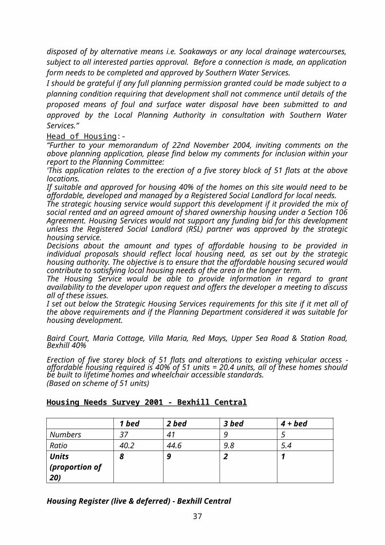
RR/2001/2162/P Change of Use of building to B1 and B8 (part retrospective) – Approval.
PROPOSAL Approval is sought for the erection of dog kennels on agricultural land to the rear of Six Acres. The original scheme showed two parallel single storey ranges each 19.4m x 3.5m (24 units in all) with cream painted rendered walls and light green profiled metal roofing sheets. The revised scheme now shows a single range, 19.4m x 3.5m, of 12 units and Kitchen/Storage accommodation. In a letter dated 8 th June 2004, the agent states “Further to your letter dated 26th May 2004, please find enclosed 4 No. copies of our drawing number 2138/1’A’, 1:500 scale block plan and 1:2500 scale location plan that have all been amended to indicate a reduced number of kennels. The kennels have also been re-sited along side the existing industrial building.My client proposes to install acoustic double glazing as suggested by Mr Steve Mills. The existing industrial building will act as an acoustic screen to the north of the proposal and the secure perimeter fence can be constructed as a 2.0m high acoustic screen.Soft coverings will be introduced within each kennel to help absorb sound, together with rockwool insulation with the roof void to prevent reverberation.My client would propose operating hours of 9.30am – 5.30pm for owners to collect/drop off their dogs and to keep the dogs locked within the building between the hours of 6.00pm and 8.00am”In an Email to the Environmental Health Officer dated 1st July 2004, the applicant states further that:-“I am writing to confirm to you that the revised application is now for 12 Kennels, which will include an isolated unit. The significant reduction in numbers will substantially reduce the noise potential.In addition, I have taken advice from acoustic consultants. I will erect 2 meter high acoustic screening which is in the form of 12” x 1” wooden panelling constructed in such a way which has been established to minimise noise. This itself is quite attractive, and will complement the planting and general cottage type outlook which I intend to create around the kennels. It will also form part of the security fencing. In addition, I will install acoustic double glazing and internal measures to absorb sound.The reduction in numbers also means that the proposed kennel block will fit within the yard of the existing building and on the site of an industrial building, which was burnt in a fire some six years ago. There is currently an existing permission to rebuild with a stable block in this spot.The general construction of the building will comply with the Model Licence Conditions for Boarding Kennels even though this has not been fully adopted by Rother District Council to ensure that the highest possible standards can be met ….”
CONSULTATIONS Parish Council:- Support a refusal. They feel the noise would be intolerable to residents and would be reflected against the workshop walls. This is more suited to a very rural area and well away from other houses.Highway Authority:- Does not wish to restrict grant of consent.Environment Agency:- “Has no objection to the proposal provided that the condition/s within this letter are imposed on any planning permission granted:Condition: No development approved by this permission shall be commenced until a scheme for the disposal of run off from hardstandings has been approved by, and implemented to the satisfaction of the Local Planning Authority.Reason: To prevent pollution of the water environment,Condition: Foul water from washing out blocks must not enter any watercourse.
37

Reason: To prevent pollution of the water environment.The applicant has been sent a copy of the Environment Agency’s Pollution Prevention Guidelines ‘PPG24 – Stables, Kennels and Catteries’.Decision Notice: Please forward a copy of the full decision notice to this office, quoting our reference number, to enable us to report on High Level Target 12.A copy of this letter has been sent to the applicant/agent”.Southern Water Services:- Does not wish to comment on this application.Director of Services – Environmental Health:-6 April 2004:-“1. The separating structures to the exercise runs must be constructed of solid
material to a height of 675mm from ground level in order to comply with the construction requirements of the Model Licence Conditions and Guidance for Dog Boarding Establishments - Animal Boarding Establishments Act 1963.
2. Also - please would you enquire as to any isolation facilities to be provided. There must be isolation facilities and none are shown.
3. What is the maximum number of dogs to be provided for?4. Floors must be laid to a minimum fall of 1 in 80 leading to mains drainage, or an
approved, localised sewage disposal system. This also in order to comply with the Model Licence Conditions”.
12 May 2004:-“Further to our site visit and the correspondence I have seen via the Council website - the site is in a quiet rural area with birdsong being the predominant noise during our visit. The development would introduce new noise of a potentially disturbing nature into the locality.Experience shows that noise from dog kennels can be very difficult to minimise, remedial measures can involve provision of special acoustic treatment to buildings (eg acoustic double glazing, silenced forced ventilation, automatic door closure, 2 metre high acoustic screens, light-tight screens) and close control over operating conditions (eg hours restrictions, not accepting noisy dogs).I believe that an acoustic consultant’s report would need to be submitted in support of the application due to the sensitive location. There are a number of residential properties with gardens in the vicinity who would be affected by this development.I note also that traffic issues have been mentioned and more generally - the development would involve buildings in the AONB.”15 July 2004 -“I have received the amended plans. I confirm that Mr Mills’ previous comments in memorandum dated 12/5/04 are still appropriate i.e. that an acoustic consultant’s report should be submitted in support of the application due to the location of the site in relation to neighbouring residential premises. The report should detail existing and predicted noise levels and any proposals for noise mitigation. The report shall be submitted to the Head of Environmental Health and noise mitigation proposals should be agreed by the Head of Environmental Health and implemented prior to commencement of the approved use.” Planning Notice:- 9 letters of objection (Woodgate Farm, Church Lane, Woodgate House, Stoddards Cottage, Stoddards Farmhouse, Stoddards Oast, Eastlands Farmhouse, Hoopers Court, Uani – Stoddards Lane; The Old Rectory, Beckley) generally on the grounds of, at least one business at this address involving lorries and vans; narrow lane with traffic travelling at unsafe speeds; noise and pollution from 30 plus dogs; AONB; dangerous single width lane used as a rat run; barking dogs obtrusive and unpleasant in valley; little noise at present; loss of rural character; increased traffic; noise and smell carried by prevailing wind; owner has little regard for planning rules and garage has been used as a separate residence; worked for 5 years
38

at RSPCA dog rehousing centre and can confirm barking dogs will be a problem; insufficient parking space; disposal of excrement would be a problem; nuisance to neighbours; devalue neighbours properties; where will dogs be walked and who will clean up; considerable nuisance during summer.10 letters of support have been received (The Rose and Crown, Rye Road; Church Cottage, Church Lane; Chestnuts, Main Street; Carpens, Hobbs Lane; Eastlands Cottage, Stoddards Lane; 6 Northridge, Northiam; Mill Cottage, Mill Corner; Badgers Oak Veterinary Clinic, Hastings Road, Northiam; 7 Neryan Court, Rye; 12a High Street, Rye) generally to the effect that: applaud attempt at private enterprise; sure measures planned to reduce noise and traffic problems; domestic dogs less noise than people anticipate; shortage of Kennels in area; employment opportunities could benefit local community; nearest kennels 3 villages away; ideal site well away from nearest dwelling; will be screened by soil bank; Kennels double glazed and sound proofed and all waste would be to a septic tank illuminating risk of odours; already 42 dogs in Stoddards Lane; very caring and sensible owner.
SUMMARY Six Acres occupies a rural location, part of the High Weald Area of Outstanding Natural Beauty on the North Western outskirts of Beckley. Planning permission for the use of a former chicken house to the rear of the dwelling for Class B1 and Class B8 purposes was granted in December 2001 (Ref: RR/2001/2162/P).Consent is now sought to establish a boarding kennels and originally this involved the construction of two parallel single storey ranges of 24 Kennels in the field to the rear of the industrial/storage building. The proposal was subsequently revised to a single range of 12 Kennels located on the south side of the industrial building. Following discussions, the applicant has revised the scheme further moving the site to the north side of the industrial building within the yard area, and on a site previously approved for stables (ref: RR/1999/1786/). The Head of Environmental Health considers that an acoustic consultant’s report should be submitted in support of the application because of the location of the site in relation to neighbouring residential properties; the report to detail existing and predicted noise levels and proposals for noise mitigation which would need to be agreed by the Head of Environmental Health. This aspect has been taken up with the agent and the necessary acoustic consultant’s report has now been received, together with an amended plan showing the dog kennel runs facing towards the existing industrial unit as suggested in the consultant’s report. The Head of Environmental Health is concerned that noise levels in the report appear to be on the high side and is discussing the matter further with the acoustic consultant before he is able to make further comments.
RECOMMENDATION: DEFER (FOR COMMENTS OF HEAD OF ENVIRONMENTAL HEALTH)
39

RR/2004/3379/P BECKLEY BRAESIDE HOUSE - LAND ADJACENT TO, MAIN STREETERECTION OF FOUR BEDROOM DETACHED HOUSE WITH NEW SHARED ACCESS PURSUANT TO OUTLINE PERMISSION RR/2003/156/PMr and Mrs R J Thompson
Statutory 8 week date: 10 January 2005
SITE The site lies on the southern side of Main Street and is within the village development boundary of Beckley. The area also lies within the High Weald Area of Outstanding Natural Beauty. Currently a Grade II Listed dwelling occupies the site and is set back some 20m from the highway. The highway frontage measures some 40m in width. A single access point is set to the western part of the site.
HISTORYRR/1999/698/P Proposed garage – ApprovedRR/2003/156/P Outline: Erection of detached dwelling house – ApprovedRR/2004/385/L Alteration to roof line to rear to create additional room – RefusedRR/2004/410/P Alteration to roof line to rear to create additional room – RefusedRR/2004/1775/P Erection of a four bedroom detached house with formation of new
vehicular access pursuant to outline permission RR/2003/156/P – Refused
PROPOSAL The proposal is to erect a four bedroom dwelling with a shared access drive. The proposed dwelling would be accessed by a proposed shared access under RR/2004/3418/P.
CONSULTATIONSParish Council: The Parish Council have no comments to make as they have personal interests.Highway Authority: Do not wish to restrict the grant of consent subject to condition.Planning Notice: No representations received.
SUMMARY The existing site would be sub-divided and the proposed dwelling set to the west of the existing dwelling. While the surrounding properties are a mix of single and two stories, the proposed dwelling would be set between a listed building and a chalet style bungalow. It is considered the proposed design would be both over bearing and out of character with the neighbouring properties and harmful to the visual appearance of the street scene. The site would be more suited to a cottage style property and not the proposed scheme, which would appear to resemble a converted barn building. The erection of the proposed garage within the front garden area would add to the harmful impact upon the street scene. This current proposal is fundamentally unchanged when compared to the refused scheme (RR/2004/1775/P). In light of this there appears no justification to support the application.
RECOMMENDATION: REFUSE (FULL PLANNING)1. The site is located within Beckley village and is considered acceptable for a
residential live/work scheme. The proposal is on a site closely related to the adjoining residential property. The proposed scheme fails to demonstrate that the design, scale and size will not have an adverse visual and environmental impact on the residential amenities of adjoining properties. The development as
40
proposed does not satisfy the requirements of Policy GD1 (ii) (iv) & (iiiv) of the Rother District Local Plan: Revised Deposit (November 2003) and Policy S1(f) of the East Sussex and Brighton & Hove Structure Plan 1991-2011.
2. RN8M - Out of character
RR/2004/3418/P BECKLEY BRAESIDE HOUSE, MAIN STREETFORMATION OF SHARED ACCESS, DRIVE AND PARKING AREAMr & Mrs R J Thomson
Statutory 8 week date: 20 January 2005
SITE The site lies on the southern side of Main Street and is within the village development boundary of Beckley. The area also lies within the High Weald Area of Outstanding Natural Beauty. Currently a Grade II Listed dwelling occupies the site and is set back some 20m from the highway. The highway frontage measures some 40m in width. A single access point is set to the western part of the site.
HISTORYRR/1999/698/P Proposed garage – ApprovedRR/2003/156/P Outline: Erection of detached dwelling house – ApprovedRR/2004/385/L Alteration to roof line to rear to create additional room – RefusedRR/2004/410/P Alteration to roof line to rear to create additional room – RefusedRR/2004/1775/P Erection of a four bedroom detached house with formation of new
vehicular access pursuant to outline permission RR/2003/156/P – Refused
PROPOSAL The proposal is to form a shared access point and parking area. The parking area will be for the existing Grade II Listed dwelling and the proposed dwelling (RR/2004/3379/P).
CONSULTATIONSParish Council: Any comments will be reported.Highway Authority: Do not wish to restrict the grant of consent subject to conditions.
SUMMARY This application has been submitted in order to create a shared access point to serve a sub-divided plot on which will stand the existing Grade II Listed dwelling and a separate plot, which currently benefits from outline planning permission (RR/2003/156/P). The application also includes details of vehicle hardstandings for each plot. While it is considered the position of the access point with the highway is acceptable, the route the proposed drive and hardstand point will occupy to the front of the Listed building, will adversely affect its setting. In light of this the application cannot be supported.
RECOMMENDATION REFUSE (FULL PLANNING)1. RN8M - Out of character
41

RR/2004/3378/P NORTHIAM THE CHAPEL, DIXTER ROADCHANGE OF USE AND CONVERSION OF SHOWROOM TO FORM FLATB A Tomlin
Statutory 8 week date: 20 January 2005
SITE This is the two storey former Methodist Chapel in the built up frontage on the west side of Dixter Road. To the south is a listed two storey dwelling (Virginia Cottage) and to the north and rear are further residential properties. Some 30m to the north two flats were formed above what is now Claire Reed Opticians in the late 1980’s (ref. RR/88/2511). The chapel was converted to use as kitchen showroom, offices and store in the 1970’s (ref. RR/76/1805). Work is at present under way on a scheme approved in September 2001 to convert the rear part of the chapel and the upper floor to three self contained flats (ref. RR/2001/1489/P). The site is within the Northiam development boundary and the boundary of the Conservation Area.
HISTORYRR/76/1805 Change of use to form kitchen, studio, shop and offices –
ApprovedRR/2001/1489/P Conversion of existing kitchen showroom, offices and store to
kitchen showroom and three self contained flats – Approved
PROPOSAL Consent is sought for the change of use and conversion of the kitchen showroom to a two bedroom flat. Externally the scheme shows the replacement of the bow type Georgian style front windows approved under RR/2001/1489/P with conventional Georgian style windows and repositioning of an existing ground floor window in the south flank wall.
CONSULTATIONSNorthiam Parish Council – Support a refusal for the following reasons:“Parking is already a problem in the vicinity of these premises. The applicant has recently converted the upper floor into two flats which are not yet occupied. When they are there no parking spaces attached to them so the road will be even more congested. A further two bedroomed flat can only add to the problem.The village has lost several business in recent years and would be sorry to see yet another one go.The proposed design of the windows is out of keeping with surrounding properties and should be revised if permission is given.”Planning Notice – Written representations have been received from the owner/occupier of a neighbouring property (24 Northridge) objecting generally on the grounds of – creation of a third flat without parking provision will add to the considerable parking problems in the locality; the design of the Georgian style windows is out of keeping with the properties above the chapel (Wellington House and the opticians) and does not reflect the chapels original design; chapel is in the Conservation Area and permission should not be granted to change the front elevation.
SUMMARY This two storey former chapel is set back behind a narrow forecourt on the west side of Dixter Road in the Northiam Conservation Area. It is not a listed building and has been in commercial use since the mid-1970’s as kitchen showroom, offices and store. Work is currently under way on a scheme approved in September 2001 to convert the rear part of the ground floor to a two bedroom flat and the whole of the
42

upper floor to 2 two bedroomed self contained flats (RR/2001/1489/P). This scheme included the provision of two new Georgian style bow windows in the shop front. The present application now shows the conversion of the relatively small remaining retail area to a further two bedroom flat.The property is in the centre of the village close to local amenities (shop, Post Office and Public House) and the proposal does not result in the loss of a significant amount of retail floorspace. Further there can be little change in traffic generation from the present use as kitchen showroom to a two bedroom flat.
RECOMMENDATION: GRANT (FULL PLANNING)1. CN11S (Large scale constructional details of new windows)
Reason: To ensure a satisfactory detailed design in accordance with the provisions of Policy S1 of the East Sussex and Brighton & Hove Structure Plan 1991-2011.
RFG: Policy S1 of the East Sussex and Brighton & Hove Structure Plan 1991-2011 and Policy GD1 of the Rother District Local Plan: Revised Deposit (November 2003).
RR/2004/3447/P NORTHIAM HIGHLANDS - LAND ADJ, DIXTER LANEERECTION OF CHALET BUNGALOW AND DOUBLE GARAGE WITH GAMES ROOM ABOVE AND FORMATION OF NEW ACCESS PURSUANT TO OUTLINE PERMISSION RR/2004/1846/P.Mr and Mrs A Griffin
Statutory 8 week date: 17 January 2005
SITE The existing dwelling Highlands stands at the eastern end of a substantial 0.4 ha plot in the built up frontage on the north side of Dixter Lane. The site comprises the western end of the garden and is rectangular in form having a frontage of some 17m and a depth of 74m. The land is within the village development boundary and outside the boundary of the Conservation Area.
HISTORYRR/91/0696/P O/A erection of bungalow with garage served by new vehicular
access - Approved.RR/94/0139/P Renewal of outline planning permission RR/91/0696/P for erection
of bungalow and garage served by a new access - Approved.RR/2004/1846/P O/A erection of chalet bungalow with garage and new access -
Approved.
PROPOSAL Approval is sought for the erection of a 4 bedroom chalet bungalow with detached double garage and games room and the formation of a new vehicular access at the eastern end of the frontage. In a supporting statement it sets out that:-
“The Area Dixter Lane is a quiet residential road on the edge of the village of Northiam. The houses in the road are individually designed with a variety of materials. There are some two storey houses as well as bungalows and chalet bungalows. The materials are predominately brick and clay tile but there is also render and tile hung elevations.The road at the plot is bounded by a mature hedge set back from the
43

road.
The Plot The plot has a narrow frontage on the road (17m) widening out to approximately 31m at the bottom of the garden. It is steeply sloping with a fall of approximately 12m from front to back.There are mature trees and shrubs on the site including an Oak at the bottom with a preservation order. The southern boundary has some existing vegetation and a fence. The northern boundary has some thick vegetation in places which will be enhanced by a new hedge.To the rear there are far reaching views across the Rother Valley.
The Design The plot lends itself to have a partial basement because of the steep slope. The layout has been designed to make best use of the slope and therefore reduce the overall footprint of the building compared to its neighbours.The building has been sited closer to the northern boundary to reduce the impact on the trees along the southern boundary. The proposal is to site the building slightly further back than its neighbour 'Badgers' to allow for sufficient turning room and to move the garage away from the frontage of the plot.From the front the appearance is of a traditional chalet bungalow constructed from dark red brick under a clay tile roof with a feature oak porch.The rear is effectively two storey using the existing drop in the land. The windows to the rear are large making best use of the view and compensating for the reduced light caused by the orientation and trees which are being retained. Windows to the sides have been kept to a minimum to reduce the impact on the neighbours. The sides are traditional brick with natural oak weatherboarding to the gable end. The rear has cream painted render to increase the light into the rooms.
Materials Red Handmade BrickCream Painted Render Oak weatherboardingOak balcony and balustradingDark red clay tiles Hardwood stained windowsHardwood stained doors
Landscaping Given the site and the steep slope the landscaping will be minimal. The balcony will provide exterior space for sitting out by the living accommodation removing the need for terracing and patio areas. The lower part of the garden will be left in its present state with the trees and vegetation in place.The top of the site will be landscaped with gravel drive and turning area edged with granite sets. The garage will be an oak framed and weather boarded traditional building.The boundary vegetation will be retained and enhanced using indigenous vegetation……”
44

CONSULTATIONSParish Council:- Support an approval but comment that: “Although supporting the approval of this application the Parish Council is concerned at the number of trees indicated for removal on the plans and would draw the attention of the planning officer to condition no.4 on the Outline Planning Permission dated 12 August 2004 which indicates that the planning authority were also concerned about the number of trees on the site and the need to maintain the characteristics of the locality.It is difficult to see how the development could take place without removing a considerable number of the existing trees but no doubt the planning officer felt this was possible when giving outline consent.”Highway Authority:- “It is noted that this is a reserved matters application pursuant to outline permission RR/04/1846. The Highway Authority was not consulted on the outline application.The Highway Authority recommends that consent be refused for the following reasons:-The approach road Dixter Lane (UC6859) is unsuitable to serve the proposed development by reason of its narrow width, poor alignment and lack of footways.Dixter Lane is only 2.5 metres wide in the vicinity of the site and is therefore not wide enough to accommodate two way traffic flow. The Highway Authority would not wish to see an increase in traffic on this road.However the principle of a dwelling at this site has been approved. Therefore if your committee is minded to approve this reserved matters application the Highway Authority recommends that the attached conditions are included in any grant of consent.”Planning Notice:- Representations have been received from the owner of a neighbouring property (Vista, Dixter Lane) objecting generally to the effect that:- still consider outline permission to be in error because plot is too narrow - proposal is over development - threatens valued trees unnecessarily on the site and adjacent land to the west at Badgers - will prejudice long term health of trees at Badgers requiring removal of many overhanging branches additional to work on trees rooted on site - understand trees at Badgers are to be subject of a TPO - there may be future difficulties which could have been avoided if site had been wider - building extends too far back beyond the established rear building line - stands too high at rear because of very deep and narrow principal level floor plan - will lead to an overbearingly large scale of development affecting both outlook from all neighbouring properties and the long distant public views into the village in the AONB - plot at Badgers has a similar profile of slope and has been constructed with a split level floor plan stepping down the slope to be less imposing - will impact on privacy of neighbours - two storey garage will be of overbearing impact on lane - concern about use of septic tank drainage - concern about loss of tree belt between Badgers and Highlands - sycamore at front should be protected as should line of trees either side of Badgers boundary - specimen beech and oaks are lost and many are subject to emergency TPO - building is too close to southern boundary requiring heavy removal of overhanging tree canopy - detail landscaping scheme is needed to protect where possible or otherwise replace all trees and hedging lost with suitable mature replacements - neighbour has a legal interest in trees on Badgers overhanging site and owns the field behind Vista and Badgers extending to abut the northwest corner of application site - all trees on site are currently protected by emergency TPO made last year - oak tree near Badgers garage will ensure tree is not harmed - generally pile foundations and no dig methods for construction and porous surface treatments should be employed to protect the trees.
SUMMARY The existing dwelling Highlands stands at the eastern end of a substantial 0.4 ha plot in the built up frontage of the north side of Dixter Lane. Outline approval for
45

the subdivision of the curtilage and the erection of a bungalow and garage served by a new access on a plot at the western end of the garden was granted in May 1991 (ref. RR/91/0696/P) and subsequently renewed in March 1994 (ref. RR/94/0139/P) and August 2004 (ref. RR/2004/1846/P). The site is within the village development boundary and outside the boundary of the Conservation Area and the proposal constitutes infilling within the existing built up frontage. The plans show a split level chalet bungalow on a slightly deeper building line than the modern split level property to the west (Badgers) with a detached garage in a forward position on a similar building line to that serving Badgers. A number of existing trees on the site are shown to be removed but the hedge along the western boundary (with Badgers) is shown to be retained and improved with local species. The advice of the Council’s Tree Adviser has been sought on this aspect of the proposal. A new vehicular access is to be formed at the eastern end of the road frontage and the Highway Authority have recommended appropriate conditions. The agent has viewed the comments from the neighbour at Vista and the Highway Authority and comments that:-“…The Highways comments on the suitability of the site for a dwelling are wrong and should not have been made. This is an application on reserved matters and therefore the principle of a dwelling has already been established. Highways should withdraw these comments prior to the application going to committee. The conditions on the design of the entrance requested by Highways does not present a problem.The principle of the dwelling has already been established and therefore the requirement for the removal of some trees has been accepted. It is impossible to construct a dwelling of any size on the property without the removal of some of the trees.We have sited the dwelling further from the road than its neighbour Badgers but with the rear in line with the neighbour on the other side Highlands. The plot is narrower at the front of the property than the rear. Siting the property as far back as possible will reduce the impact on the existing vegetation on the plot boundary as the plot is wider.The height of the property is similar to its neighbours and therefore the bulk when viewed from the rear will be of a similar impact as Badgers.The point on sewage is valid and we are planning to install a pump chamber to use the existing sewage located in Dixter Lane.The garage is a standard sized double garage with use made of the space in the roof and is not two storey as mentioned in the comments.Currently the only tree with a Preservation Order is the Oak to the rear of the plot. This will be unaffected by the construction. It is my Client's intention to maintain as far as possible the vegetation between Highlands and Badgers. If required we can commission an Aboriculturalist report into the likely impact of the construction, methods of protection of the existing vegetation and ways of mitigating the impact.”In principle the scheme is one I would feel able to support although I have some concerns about the impact of the balcony on neighbours’ amenities and the proximity of the garage to the boundary trees on the west side of the plot. These points have been taken up with the agent and I hope to have his response together with my Tree Adviser’s comments available at the meeting.Provided these aspects are satisfactorily resolved it will be my
RECOMMENDATION: APPROVE (RESERVED MATTERS)1. CN7G Amended delete ‘indicating … dwelling’. (Schedule of materials).2. The garage building shall be used for domestic garaging and games room and
for no other purpose.
46

Reason: To enable the Local Planning Authority to regulate and control the development of the land and to accord with the provisions of Policy S1 of the East Sussex and Brighton & Hove Structure Plan 1991-2011.
3. CN13I (Hedge retention - access).4. CN13A (Landscaping).5. CN9I Amended (Boundary fencing - non estate development) - delete reference
to walling.6. CN10A (Highway conditions)7. CN8C (Foul and surface water drainage)+Note N1B (Amended plans).
RR/2004/3239/P SALEHURST GEORGE HILL AND A21 – LAND AT JUNCTION OF ROBERTSBRIDGETELECOMMUNICATIONS INSTALLATION COMPRISING OF A 10M HIGH COLUMN 3 MAST WITH 3 NO. DUAL BAND POLAR ANTENNAS WITH A 600MM TRANSMISSION DISH ALONG WITH A 4 PACK OF EQUIPMENT CABINETS LOCATED AT GROUND LEVELOrange Personal Communications Services Limited
Statutory 8 week date: 27 December 2004
This application was deferred at the last meeting for site inspection.
SITE The proposed site is on highway land adjoining the north side of the southern road junction leading from the A21 into Robertsbridge Village.
HISTORYNone.
PROPOSAL The proposed mast would comprise slimline column with a maximum height of 10m. At the top would be fixed 3 antennas and a dish immediately below. At ground level and adjacent to the mast, there would be 4 equipment cabinets and an electric feeder pillar. These would be painted dark green. The mast would be grey in colour. The mast and cabinets would be sited at the back of the highway verge where it would adjoin an existing boundary fence and be backed by a group of existing trees and bushes in the adjoining field.In the Supporting Statement, Orange state that Robertsbridge has poor coverage due to the lack of mobile radio base stations in the immediate area. The signal coverage plans submitted shows a high, signal strength to the low lying areas of the village, and the immediate surrounding area.The Statement lists five alternative sites that were considered. Three of these were discounted due to acquisition problems. Two more possible alternative sites were discounted on the grounds of inferior coverage (The Mill rooftop) and inferior coverage unless substantially higher (Russets Farm, Greenfield). However, ‘The Mill’ site is listed as a ”good back-up option if required”.A Declaration of Conformity with ICNIRP Public Exposure Guidelines has been submitted.
CONSULTATIONSParish Council - Object to proposal commenting that:-
47

“The Parish Council was consulted on this prior to the application being submitted. Unfortunately our response, which was acknowledged by Orange, is not referred to in the application. The comment made to Orange was the Parish Council objects to the siting of the mast, as they consider that it would be grossly intrusive at this point in the village. Indeed the council feels that the intrusion, right at the entrance to our mediaeval village, would be even greater than anticipated in view of the Highways Agency recommendation that a suitable protection barrier should be installed.”Highways Agency – Has no objection subject to condition.Highway Authority – Does not wish to restrict grant of consent subject to the following observation: “The site plan indicates the position of the proposed site access which does not fall within the site boundary shown. It is recommended that an amended plan be submitted showing the position of the access within the site so that highway conditions can be issued. The Highway Authority would insist on a dropped kerb and grasscrete for verge hardening for this scheme so that maintenance vehicles can enter and exit the site safely”.Director of Services – Environment – No comments received.Planning Notice – No comments received.
SUMMARY The main consideration in this case is its visual impact upon the landscape and Area of Outstanding Natural Beauty. This junction has a considerable amount of existing street furniture and there are several tall lamp columns, road signs and illuminated bollards. The proposed mast is relatively low in comparison to the lamp columns, and would have the advantage of being partly screened by adjacent trees so that only the top third would be prominent above the tree line. The ground level cabinets are unlikely to be visually conspicuous. Given these local characteristics and the fact that this site gives optimum coverage, I take the view that it strikes an acceptable balance between visual impact and the Operators technical requirements and is supported. However an amended plan is required incorporating the Highway Authority’s access requirements.
RECOMMENDATION GRANT (FULL PLANNING) DELEGATED (RECEIPT OF AMENDED PLAN INCORPORATING HIGHWAY AUTHORITY’S REQUIREMENTS)1. The antennae and all equipment hereby permitted on the site shall be removed
from the land on which it is situated within 6 months of the time when it is no longer required for telecommunication purposes.Reason: To enable the Local Planning Authority to regulate and control the development of the land in accordance with Government Advice in Planning Policy Guidance Note 8 and Policy EN30 of the East Sussex and Brighton & Hove Structure Plan 1991-2011.
2. Detailed plans for the screen planting of the equipment cabinets shall be submitted to and be subject to the approval of the Local Planning Authority, the planting shall be carried out at the time of development or at such later date as may be agreed in writing by the Local Planning Authority, and in any event within 6 months from the completion of the development. Any trees and/or shrubs removed, becoming severely damaged or diseased, or which die within 5 years of planting shall be replaced by trees and/or shrubs of similar size and species to those originally required to be planted.Reason: To improve and maintain the characteristics of the locality and to accord with Policy S1 of the East Sussex and Brighton & Hove Structure Plan 1991-2011, and Policy GD1 of the Rother District Local Plan: Revised Deposit (November 2003).
48
3. Details of a barrier protection system shall be submitted to and approved by the Local Planning Authority, in consultation with the Highways Agency. The barrier system shall be installed in accordance with the approved details, at the time of development, and unless otherwise agreed with the Local Planning Authority, permanently retained thereafter.Reason: In the interests of highway safety and to accord with Policy S1 of the East Sussex and Brighton & Hove Structure Plan 1991-2011 and GD1 of the Rother District Local Plan: Revised Deposit (November 2003).
4. As recommended by the Highway Authority.N1B (Original and amended plans)
RR/2004/2819/P WESTFIELD CARR TAYLOR WINES LTDREBUILDING OF EXISTING WINERY WITH ANCILLARY SHOP, OFFICE TASTING ROOMS RESTAURANT AND EXHIBITION SPACE. ENLARGEMENT OF BONDED WAREHOUSECarr Taylor Wines Ltd
Statutory 13 week date: 14 February 2005
I have added this site to your list for inspection.
SITE Carr Taylor Vineyards is located to the north west of the village of Westfield some 340m from the junction between Wheel Lane (C23) and Parsonage Lane (unclassified). The site contains a variety of small scale agricultural and portacabin type buildings and falls within the High Weald AONB. Planning permission (RR/90/1868/P) has previously been granted to refurbish existing buildings, erect new buildings and to expand the business in 1990 and renewed under RR/95/1724/P in 1996. A further application RR/2001/849/P to renew the permission was deemed refused in 2002 following a direction from GOSE that the proposal was EIA development and that no such EIA has been submitted.
HISTORYRR/82/0676 Use of vineyard as a tourist attraction and use of existing
buildings as winery. Erection of general purpose farm building, tourist office and farm produce display and car parking facilities – Approved on a personal basis.
RR/90/1868/P Part demolition/refurbishment of existing buildings and erection of new building to expand winery and tourism – Approved with conditions
RR/95/1724/P Renewal of RR/90/1868/P – Approved following reference to GOSE under the departure procedures.
RR/2001/849/P Renewal of planning permission RR/95/1724/P for part demolition and refurbishment of existing buildings and erection of new buildings to expand existing winery together with improved tourism facilities – Deemed refusal following confirmation from GOSE that proposal was EIA development and that no such E/A had been submitted.
PROPOSAL The existing winery comprises a range of ad-hoc buildings linked to the western end of a dwelling together with a portacabin (office) and detached bonded warehouse. These buildings are functional in design and materials and have no
49
architectural merit. The main building also accommodates the winery together with a restaurant and shop. Apart from the bonded warehouse and dwelling, the building housing the winery, restaurant and shop would be demolished and replaced by a single larger building. This would be approx 12m longer than the existing building and be contemporary in design and its use of materials (eg. cedar cladding and glass). Its ridgeline would follow that of the adjacent house with coloured profiled roofing to match the clay tiles. A small glazed viewing gallery above the ridge would afford visitors a panoramic view of the vineyard. The building would house wine storage tanks a bottling room, wine/food shop at ground floor level and short term bonded warehouse, 2 tasting rooms, exhibition space and reception room at first floor level. The existing separate bonded warehouse would be extended at its western end by 23m in matching materials. A copy supporting report submitted with the application is contained in the separate APPENDIX DOCUMENT relating to this meeting 20 January 2005. Also appended is a copy letter dated 4 October 2004 from Batcheller Thacker and a copy letter dated 12 October 2004 that they sent to GOSE.
CONSULTATIONSParish Council – “Members expressed disappointment that there had been no detailed discussions between the applicant and Rother DC prior to submission of the plans. This had resulted in many issues being unresolved. Members invited the applicant to consider and discuss with Rother DC the following issues and amend the proposal accordingly:a Confirmation of any requirement for a full EIA or Limited landscape,
Environmental and Highways Assessmentsb Impact of increased traffic on Wheel Lanec Role of business, is it purely based on wines from immediate land holding or
additional processing of imported wines and other drinksd Clarification of estimates of visitors numbers including coachese Impact on local employmentf Planning conditions on access roadg Proposed Exit Road shown on plans which is actually a grass trackh Clarification of Parking Spacesi Clarification of ownership of landj Proposed operating hours of Restaurantk Look out tower (overlooking neighbours)l Size and operating hours of Restaurantm Impact of lighting in AONBn Security proposals given bonded warehouseo Landscaping (removal of any trees)p Large Glass Area reflecting sun to nearby residential properties”.Highway Authority – Comments awaited.Environment Agency – Has no objection.Southern Water – Has no objection. The proposed winery will be subject to the terms and conditions of the Trade Effluent Agreement for the existing winery.Director of Services – Environment – “I have spoken with the agent regarding this application and from the information given I have no need to request any conditions.As an informative or note please add:The activity may constitute a prescribed process under the Pollution Prevention and Control Act 1999.The applicant or agent is advised to contact the Environmental Health Service for further details”.
50

Sussex Police – “This is a relatively low crime area and I do not identify any major concern with the proposals. Some thefts of equipment have been experienced but the new design does address this risk”.Planning Notice – Objections received from the occupiers of 4, 5, 6 and 9 Yew Tree House include: 1987 permission does not allow for a café, sale of goods not produced on the Farm or for processing of raw materials or products not produced on farm; present application is therefore a Change of Use to a restaurant, sale of goods and processing of items not produced on Yew Tree Farm; these changes are not supported by Rother District Local Plan: Revised Deposit (November 2003); GOSE’s ruling that development is not EIA development is flawed and I am seeking a Judicial Review; Departure from Rother District Local Plan: Revised Deposit (November 2003); additional processing would be better placed in an urban setting; there is no public transport to the site; building is out of character and will affect visual appearance of AONB; viewing turret would be extremely visible during day and night; would exacerbate problems of reflection and visual impairment; would prejudice character of contiguous ancient woodland; is in a vulnerable countryside gap; if additional processing capacity is needed Policy VL10 shows that land is allocated at Wheel Lane Business Park; outside development boundary; not near local service centres; would detract from openness of Battle to Hastings Gap; amenities of adjoining properties would be wrecked by overlooking from the observation tower the end of the first floor terrace and other windows; all should be frosted glass and screens erected; increased noise from customers and winery processes including bottling; boundary noise level condition required; the application is for 88 parking spaces or the parking of coaches or lorries; a covenant on land between Yew Tree House and Yew Tree Farm restricts use to garden or tennis court; Wheel Lane is narrow without pedestrian paths and well used; probable traffic increase of 10%; existing service road mentioned does not actually exist; changing this to paved road would change character of AONB and reduce amenity of 9 flats in Yew Tree House; application does not include change of use; building does not reflect local architecture; since photographs taken the row of 60 feet high poplars have been removed and a number of other trees and shrubs felled; out of proportion to the landscape and large area of reflecting glass; should be a survey to see of protected bats and owls roost in present buildings; the contiguous old iron workings need to be recognised; insufficient traffic information to guide planners; development needs to satisfy Rother District Local Plan: Revised Deposit (November 2003) Policies EM3, EM7 and EM14; contrary to East Sussex and Brighton & Hove Structure Plan 1991-2011 Policies EN2 and EN3; PPS7 shows national concern for continued protection of AONB and amenity of neighbours to new types of on farm developments; floodlighting should not be allowed; present opening hours are 10:00 to 17:00 any consent should be limited to these hours or a minor variation; will information be available by time a decision is taken; may possibly be rights under Human Rights Act; would support a modernisation subject to more sensitive treatment of building, traffic, overlooking, noise, opening hours, light pollution and wildlife within AONB; it is the scale, balance and intrusive nature that makes me oppose the present application; argument that Westfield needs further business and employment opportunities is completely without foundation; local infrastructure is quite unable to sustain a larger business; new building would completely spoil our view and outlook; decrease value of our flats; Wheel Lane is dangerously narrow in places and cannot accommodate additional traffic; there are other more suitable sites.A full copy of the representations received from 4 Yew Tree House are contained in the separate APPENDIX DOCUMENT relating to this meeting 20 January 2005.A letter of support from “1066 Country” states – “The Carr Taylor Vineyard is already one of the major attractions in 1066 Country and is very popular with domestic and
51

overseas visitors alike. Indeed, we regularly take journalists and travel trade professionals there, and it is always a popular visit.The plans for expansion will help turn a good attraction into an excellent one, and it has my wholehearted support. As you may be aware, tourism generates £374m for the local economy in 1066 Country, and is directly responsible for providing over 9000 jobs in the area. Investment on the scale proposed by Carr-Taylor can only help the tourism product locally. Not only does it help create new jobs directly, it strengthens the offer across the whole area and so helps safeguard other jobs in the industry too.
SUMMARY For comparison purposes, the floor areas of the existing and proposed buildings have been approximately calculated. It is my estimation that the proposals would result in a 112% approx increase in floor space. Previous proposal RR/90/1868/P would have resulted in a 304% approx increase. From these figures, it can be seen that the current proposal is only one third the size of the previous application and is the reason why GOSE determined that it would not be EIA development. The previous application would also have included 49 car spaces, 4 coach bays, a restaurant with 136 covers and 160m2 shop. The current proposal would include 30 car parking spaces, a restaurant with 72 covers and a 306m2 shop.The main issues to be considered include:1. Impact upon landscape and AONB2. Impact upon adjoining and local amenity3. Impact upon highway safetyThese issues need to be judged against general policies contained in the East Sussex and Brighton & Hove Structure Plan 1991-2011 and Rother District Local Plan: Revised Deposit (November 2003) and in particular, the following: East Sussex and Brighton & Hove Structure Plan 1991-2011E1 In order to improve the economy and prosperity of the plan area a strong,
positive approach to economic development, integrated with environmental protection, will be pursued which will include:-
d) fostering the growth of existing businesses;(i) encouraging the tourist industry by supporting investment to provide high quality
attractions and accommodation;E17 To promote and maintain a range of employment opportunities in the rural areas,
support will be given to appropriate employment development in accordance with the needs of the area and policies S7-S12. In particular support will be given to:
a) employment provision in the East Sussex Rural Development Area and other identified priority areas;
b) enterprises using and marketing local produce; andc) developing the tourist industryLT1 Leisure and tourism activities and facilities will be strengthened and developed to
meet the needs of residents and visitors and bring economic benefits, where this is compatible with the conservation of the environment and distinctive local character.
LT2 Proposals for the provision of high quality leisure, tourist and conference facilities in the plan area will be encouraged and supported, which:-
a) are compatible with the retention of important landscape and townscape character;
Rother District Local Plan: Revised Deposit (November 2003)Policy EM1
Large-scale business development will be focussed upon established and allocated business areas within development boundaries. Smaller-scale business activities will be accommodated by:
52

iii) the conversion, redevelopment or extension of sites and premises outside development boundaries where this does not detract from the character or appearance of the area as well as meeting general development considerations
Policy EM7Proposals for new or extended tourist attractions or visitors facilities will be permitted where it accords with Policy DS1 and GD1. Particular support will be given to develop good quality attractions that support the built and natural qualities of the area.
My comments upon the three main issues identified above are as follows:
1. Impact upon landscape and AONBIn terms of size and design, the building now proposed would have significantly less visual impact in the landscape than the previously proposed building. That building would have been much higher than the adjoining dwelling with a large roof mass. The roof of the proposed building would be low pitched and would be no higher than the existing dwelling. Until recently, the existing buildings were partly screened from southern views across the landscape by a line of tall poplar trees. However, these have now been removed, exposing the building to greater view. Also exposed to greater view are the tall cylinder storage tanks and other materials stored outside and adjoining the south side of the main building and west side of the bonded warehouse. However, if approved, the replacement building and extended bonded warehouse would render it unnecessary to store these items outside. This would be of significant benefit to the appearance of the landscape. Furthermore, whilst local residents have raised concern over possible reflection from such large areas of glass and light pollution, much of the glass at first floor level would be beneath a deep canopy thus eliminating reflection. Significant light pollution is also unlikely given the proposed operating hours condition. Notwithstanding, I take the view that the line of poplar trees that have been felled should be replaced. Provided this is achieved I would be satisfied that the proposed buildings would have an acceptable impact upon the appearance of the landscape and AONB.
2. Impact upon adjoining and local amenityThe residents of Yew Tree House are concerned about loss of privacy resulting from the viewing gallery and open verandahs. However, the proposed replacement building would be approx. 40m from the boundary with Yew Tree House and approx. 70m from Yew Tree House itself. Furthermore, the gardens of Yew Tree House are communal and overlooked by the occupants of other flats within the building. A refusal of planning permission on grounds of overlooking and loss of privacy would not, in my opinion, be justified. However, a landscaping condition requiring tree planting on the boundary (e.g. more poplar trees) would, in my opinion be appropriate, and I have asked the applicants to indicate this on an amended plan. The submitted plan also indicates an “existing service road” leading from the south side of the winery, past Yew Tree House and into Wheel Lane. Whilst a vehicular access does exist at this point, the service road does not. I have therefore asked for this to be deleted from the plan. With regard to impact resulting from additional traffic and visitor numbers, the following comments have been extracted from the supporting information:-“2. Attached is a schedule showing average weekly vehicle numbers for
coaches and cars going back to January 2002. You will note that this is a significant existing business.
53
The primary purpose of the scheme is to improve the economic return from the existing visitor numbers. The current average spend per person is in the region of £4.00. It is hoped that, through better facilities, this can be increased to over £8.00 per head. Initial business projections indicate that this is feasible.You will appreciate that, whilst Yew Tree Farm is clearly a successful business, it is not in a primary location. The owners recognise this; hence their focus on improving the return from visitor numbers rather than seeking any significant increase in the volume of visitors.Having consulted with principal clients, namely the coach party operators, it is predicted that an increase in coach numbers of between 5% and 10% might be achievable in time. This equates to between one and two additional coaches per week.Through consulting with individual visitors, arriving by private motorcar, it is hoped that an increase in visitor numbers here might be achieved between 8% and 12%. On current figures this would equate to between one and three additional cars per day.Whilst I hope that I have now provided sufficient information on which you can reassess the situation, I would be pleased to discuss this matter further.”
From this information I would not expect any additional impact to be significant. Notwithstanding, I have asked the applicants to supply me with details of proposed operating hours including their intentions regarding operation of the restaurant and nature of proposed food sales.
3. Impact upon highway safetyAt the time of writing this report, I have not received any comments from the Highway Authority. Their comments upon the previous proposal expressed concern over its “excessive scale” but felt that “…bearing in mind the existing use of the site, the access roads are capable of dealing with a modest increase in traffic…”Any comments received will be reported at the meeting.
In addition to the information requested above, I have also asked the applicants to advise the number of additional employees, if any, proposed so that the impact and benefit to local employment can be properly weighed and assessed. I have also asked the Director of Services - Environment to advise me whether or not any measures to control noise would be appropriate. Provided the additional information is satisfactory and the Highway Authority has no objection, I would expect to support the proposal. If Members are minded to support the proposal then the application will need to be forwarded to GOSE under departure procedures.
RECOMMENDATION: GRANT (FULL PLANNING) DELEGATED (RECEIPT OF SATISFACTORY ADDITIONAL INFORMATION/NO OBJECTION FROM HIGHWAY AUTHORITY/DEPARTURE PROCEDURES)1. CN7B amended a) the roofing materials b) wall materials (External materials).2. Notwithstanding the provisions of the Town and Country Planning (Use Classes)
Order 1987, (or any Order revoking or re-enacting this Order) the premises shall be used for the purposes stated in the application and as defined on the submitted drawings only and not otherwise. The restaurant, wine and food shop, tasting rooms and exhibition space shall only be used in conjunction with the winery and shall not be used for any purpose that is not associated therewith.
54

Reason: To ensure an appropriate use of the property/site and to preserve the amenities of the area in accordance with Policy S1 of the East Sussex and Brighton & Hove Structure Plan 1991-2011 and Policy GD1 of the Rother District Local Plan: Revised Deposit (November 2003).
3. (Hours of operation condition).4. No materials, plant or other equipment of any description shall be stored on the
site in the open other than to the extent and in such positions as may be approved by the Local Planning Authority in writing.Reason: To preserve the amenities of the locality; to enable the Local Planning Authority to control the development of the site and to accord with Policy S1 of the East Sussex and Brighton & Hove Structure Plan 1991-2011 and Policy GD1 of the Rother District Local Plan: Revised Deposit (November 2003).
5. CN13A amended by adding “The scheme of landscaping shall include replacing the line of recently felled poplar trees together with the planting of a similar tree screen on the eastern boundary.”Reason: To reduce the visual impact of the proposed buildings upon the landscape and AONB; to preserve the amenities of the occupiers of the adjoining flats in Yew Tree House and to accord with Policy S1 of the East Sussex and Brighton & Hove Structure Plan 1991-2011 and Policy GD1 of the Rother District Local Plan: Revised Deposit (November 2003).
6. CN13B (Implementation of landscaping scheme).7. CN12L (Floodlighting control).8. Detailed plans for any boundary and/or retaining walls, fences, surface treatment
of roads, parking and servicing areas, hard landscaping and paving, shall be submitted to and be subject to the approval of the Local Planning Authority and shall be carried out at the time of development or at such later date as may be agreed in writing with the Local Planning Authority.Reason: To provide for the proper development of the site and to accord with Policy S1 of the East Sussex and Brighton & Hove Structure Plan 1991-2011 and Policy GD1 of the Rother District Local Plan: Revised Deposit (November 2003).
9. CN8C amended by deleting “before any work on the site commences.” (Foul and surface water details).
10. Any facilities for the storage of oils, fuels or chemicals shall be sited on impervious bases and surrounded by impervious bund walls. The bund capacity shall give 110% of the total volume for single and hydraulically linked tanks. If there is multiple tankage, the bund capacity shall be 110% of the largest tank or 25% of the total capacity of all tanks, whichever is the greatest. All filling points, vents, gauges and sight glasses and overflow pipes shall be located within the bund. There shall be no outlet connecting the bund to any drain, sewer or watercourse or discharging onto the ground. Associated pipework shall be located above ground where possible and protected from accidental damage.Reason: To prevent pollution of the water environment and to accord with Policy S1(g) of the East Sussex and Brighton & Hove Structure Plan 1991-2011 and Policy GD1 of the Rother District Local Plan: Revised Deposit (November 2003).
11. (As recommended by Director of Services - Environment).12. (As recommended by the Highway Authority).Note 1: (N1B - Original and amended plan/s).Note 2: The activity may constitute a prescribed process under the Pollution Prevention and Control Act 1999. The applicant or agent is advised to contact the Environmental Health Services for further details.
55

RFG: Policies S1, EN2, EN3, E1, E17, LT1 and LT2 of the East Sussex and Brighton & Hove Structure Plan 1991-2011 and Policies GD1, EM1 and EM7 of the Rother District Local Plan: Revised Deposit (November 2003).
RR/2004/3414/P CAMBER BROOKSIDE FARMWORKS TO CREATE ENVIRONMENT FOR NEWTS, INCLUDING FORMATION OF PONDS, MOUNDINGS, AND PLANTING OF SMALL COPSES AND AREA OF INFORMAL OPEN SPACEBurrows Investment Limited
Statutory 8 week date: 18 January 2005
This application was deferred at your last meeting to await views of consultees, including Camber Parish Council and for further consideration of open space layout and safety issues.
SITE This application relates to approximately 0.63 ha of land, which is part of the approved development site at Brookside Farm. The site was approved as an area of public open space and the Section 106 Obligation makes provision for the layout of a football pitch. The site adjoins an SSSI.
HISTORY (Relevant)RR/93/736/P O/a residential development and access and provision of public
open space - Approved 31/3/00 and Section 106 Planning Agreement.
RR/2002/2374/P Erection of 170 residential units pursuant to o/a RR/93/736/P -Approved 30/3/04.
RR/2004/1987/P Revision of previously approved development on Plots 67-81 for 12 flats to be replaced with 10 Cottages and 6 Flats above car ports – Approved.
PROPOSAL As part of survey work carried out and discussion with English Nature it is now proposed to use the area set aside for a football pitch as an area of informal open space, which will include mitigation measures required to provide the creation of a new environment suitable for amphibians, including newts. The proposal includes the creation of shallow ponds and mounds with informal planted areas. The area of informal open space will have full public access and be managed by a Management Company, which will operate for the whole area of the site.
CONSULTATIONSParish Council:- Awaited.Romney Marsh Area Internal Drainage Board:- No objection.Environment Agency:- No objection.English Nature:- “The new proposals for the previously proposed playing field are to be welcomed. English Nature had serious concerns that a playing field would be a possible source of leachates such as herbicides and/or fertilisers that would enter into the watercourses and lead to potential damage to the SSSI.I would make the following comments with regard to the new proposals Could there be an indication provided as to the extent of new pond habitat being
created compared with the area of habitat lost on the development site?56

The proposed ponds are being created as part of a mitigation package for great crested newt that has been found to be present within the housing development site at Brookside Farm. This proposal suggests only two ponds. A larger number of ponds of varying depth and size would greatly enhance the proposal and provide a more suitable habitat for great crested newt that would withstand seasonal fluctuations. Two relatively large ponds could in time become populated with fish. Fish would prey on the great crested newt population and therefore wipe them out from this site. I would suggest at least 4 ponds are created.
I would also suggest that fewer numbers of trees are planted. As the trees mature these will lead to shading out of the water features and will eventually make them unsuitable habitat for newts and also pond life in general. Although a landscape feature, trees can become a site management issue in cases where wetland habitat is present.”
Community Development Management:-Awaited.Planning Notice:- No representations received.
SUMMARY The issue for consideration is whether a formal public playing field is required on the site, or whether its use purely as an informal open space is acceptable. The provision of a football pitch and transfer of the land to Camber Parish Council is required by the existing Section 106 Planning Agreement, which stems from the Parish Council’s view on the need for a football pitch when the outline application was first submitted in 1993.I understand that the applicant has had discussions with the Parish Council, who no longer wish to pursue the formal provision of a football pitch on the site. If this is the case, I can support the alternative open space use.Subject to satisfactory responses in relation to the application, a formal variation of the existing Section 106 Agreement will be required.The applicant’s comments and those of the Parish Council are awaited. Some amendment of the plans would be necessary to meet the requirements of English Nature.
RECOMMENDATION: GRANT (FULL PLANNING) DELEGATED (VARIATION OF SECTION 106 AGREEMENT/CONSULTATION RESPONSES/AMENDED PLAN).1. CN13A (Landscaping Scheme).2. CN13 B (Implementation of Landscaping).3. Prior to the commencement of development, details of the following matters
will be submitted to, and be approved by the Local Planning Authority:-a) fencing/boundary treatment on the siteb) provision of public footpathsc) proposed management of the open space.
The development shall be carried out in accordance with the approved details.
RFG: Policy S1 of the East Sussex and Brighton & Hove Structure Plan 1991-2011 and Policy GD1 of the Rother District Local Plan: Revised Deposit (November 2003).
57

RR/2004/3417/P IDEN RANDOLPHS FARM COTTAGE, RANDOLPH LANEDEMOLITION OF COTTAGE, GARAGE AND OUTBUILDINGS. ERECTION OF DWELLING HOUSE WITH DETACHED TRIPLE GARAGE WITH ATTIC ROOM ABOVE.Mr and Mrs Morris
Statutory 8 week date: 25 January 2005 This application has been added to the Committee Site inspection List.
SITE This is a detached bungalow located on the North side of Randolph Lane.
HISTORYParish Council: Iden PC consider the proposed new dwelling far too large for the elevated site on which existing bungalow stands. Cllrs would ask for a Committee decision on the application: work is being undertaken now.Highway Authority: Do not wish to restrict the grant of consent.Environment Agency: Raise no objection.Planning Notice: No comments received.
PROPOSAL This application seeks permission to erect a two storey dwelling, swimming pool and a detached garage building.
CONSULTATIONSParish Council – NoneHighway Authority – NoneEnvironment Agency – NoneDirector of Community Services – NoneSouthern Water – NonePlanning Notice – One letter of objection has been received.
58

SUMMARY The site is located outside any village development boundary and within the High Weald area of outstanding Natural Beauty. The existing single storey dwelling stands within a site located some 300m along an unadopted access road, known as Randolph Lane and measures some 55m wide by some 23m deep is of a generally regular shape and consists of three main buildings. These include the dwelling, which measures some 78m² and two outbuildings. It is considered none of these buildings afford a positive contribution to the amenity of the area or enhance the vernacular found within the vicinity. However, the dwelling opposite is of a style more commonly associated with urban areas (circa. mid 20th Century). The proposal to replace the existing dwelling and outbuildings is considered acceptable in principle, though concern is expressed at the proposed choice of design submitted for both the garage building and the dwelling. While the site is not visible from the main road some 300m to the east, the plot is prominent in the surrounding landscape and therefore any replacement building must enhance the amenity of the area. The mass and scale of the garage building is considered excessive due to the proposed footprint of 60m² and standing in excess of 6m high. The proposed dwelling has a footprint measuring some 162m² and has a first floor area measuring some 54m² with a separate terrace measuring some 31.5m². The proposed footprint alone represents an increase in excess of 100% above the existing unit. In terms of the proposed design of the dwelling, the introduction of a first floor terrace area is out of keeping with the single storey building to be replaced has a uniform roofline, while the proposed unit does not. The inclusion of an outdoor swimming pool serving a new dwelling within the plot may be acceptable. It is considered that in its current design, the mass and scale of the proposed dwelling and outbuilding is out of keeping with the landscape and rural setting and would be detrimental to it and therefore cannot be supported.
RECOMMENDATION: REFUSE (FULL PLANNING)1. The site is within the countryside, outside any town or village development
boundary defined within the Rother District Local Plan: Revised Deposit (November 2003). Within such areas the plan contains a strong presumption against residential development unless it meets one of the exceptions described. In this case the proposal does not involve the replacement of an existing dwelling being of a comparable size. The floor area of the new dwelling would be considerable greater than that of the existing dwelling. Also, by virtue of the juxtaposed roof design, the scheme would be harmful to the character and visual amenity of the rural setting. The proposal therefore conflicts with Policy HG10(i) of the Rother District Local Plan: Revised Deposit (November 2003) and Policy S1 of the East Sussex and Brighton & Hove Structure Plan 1991-2011.
2. The site lies within the High Weald Area of Outstanding Natural Beauty where Policies EN2, EN3 and S1(j) of the East Sussex and Brighton & Hove Structure Plan 1991 - 2011 and Policy DS1(vi) of the Rother District Local Plan: Revised Deposit (November 2003) indicate that development will be carefully controlled to protect the character of the area. It is considered that the proposal does not meet this objective and it would cause harm to the rural character of the area.
RR/2004/3410/P ETCHINGHAM FORGE BUNGALOW, FONTRIDGE LANEDEMOLITION OF EXISTING DWELLING AND CONSTRUCTION OF NEW DWELLINGH & J Kruisinga
Statutory 8 week date: 12 January 2005 59
This application has been included on the list of Committee site inspections for 18 January 2005.
SITE The application relates to a single storey dwelling of period character, positioned close to the south-eastern side of Fontridge Lane. The walls are mainly of stone construction and the roof is clad with plain tiles. It stands within a relatively small, linear shaped residential curtilage. The site lies outside any identified settlement ‘Development Boundary’ in an area where countryside policies apply. It is also within the High Weald Area of Outstanding Natural Beauty.
HISTORYRR/92/0387/P Outline: Erection of replacement dwelling within curtilage of Forge
Bungalow and alteration to access - Approved.
PROPOSAL The application is a detailed full application. It is for the demolition of the existing single storey dwelling and the construction of a replacement two storey dwelling within the curtilage.
CONSULTATIONSParish Council:- No comments received.Environment Agency:- No objection.Director of Services – Amenities Division:- No objection to any replacement dwelling being drained into the existing pond.Planning Notice:- No comments received.
SUMMARY The application site is located within the countryside between the villages of Etchingham and Robertsbridge. It falls well outside the Development Boundary of either of these villages as identified on the Rother District Local Plan: Revised Deposit (November 2003). Whist there is no objection in principle to a replacement dwelling on this site, Policy HG10(i) of the Rother District Local Plan: Revised Deposit (November 2003) states that replacement dwellings should be of comparable size. The existing dwelling is a modest sized, single storey, period cottage of predominantly stone construction with a plain clay tile roof. The floor space including a day-room extension is approximately 76 square metres. The proposed replacement dwelling would have a floor area of approximately 148 square metres on two floors. Whilst I note that measures are proposed to minimise the overall height of the new building – specifically, the finished floor level of the building would be lowered by excavating into the sloping site and forming a retaining wall and a lower ridge line would be achieved by incorporating a 40 degree roof pitch – the proposal would result in a materially larger building on the site. It is considered that the development proposal does not accord with Policy HG10(I) of the Rother District Local Plan: Revised Deposit (November 2003). A supporting letter has been provided with the application and this can be viewed in full on the web site.
RECOMMENDATION: REFUSE (FULL PLANNING)1. The site is within the countryside, outside any town or village development
boundary defined in the Rother District Local Plan: Revised Deposit (November 2003). Within such areas the plan contains a strong presumption against residential development unless it meets one of the exceptions described. In this case the proposal does not involve the replacement of an existing dwelling on a one for one basis which would result in the replacement dwelling being of a
60

comparable size. The floor area and volume of the new dwelling would be significantly greater than that of the existing dwelling. Moreover, the design of the dwelling would not be more in keeping than the building it would replace and an exception to the provisions contained in HG10(i) would not be justified in this case. The proposal, therefore, conflicts with Policy HG10(i) of the Rother District Local Plan: Revised Deposit (November 2003).
2. RN4B (Non-essential development - AONB) (Amended - EN2, S1(j) of the East Sussex and Brighton & Hove Structure Plan 1991-2011).
RR/2004/3223/P TICEHURST BATTENHURST FARM, BATTENHURST LANE, STONEGATEDEMOLITION OF EXISTING HOUSE AND OUT BUILDINGS. ERECTION OF POOL HOUSE, NEW DWELLING, GARAGE, TENNIS COURT AND CONVERSION OF EXISTING BUILDING TO STAFF AND GUEST ACCOMMODATIONP Neilson
Statutory 8 week date: 22 December 2004
SITE A detached dwelling in a countryside location (AONB) reached by a short track to the west side of Battenhurst Road. It formerly comprised a pair of farm cottages but is now occupied as one unit. There are a number of outbuildings, including a single storey, brick and tile, former agricultural building, part of which has planning permission for use as an annexe (RR/96/154/P). A large ‘Atcost’ type agricultural building is presently disused. There is a public footpath crossing the site.
HISTORYRR/96/1584/P Change of use of existing farm buildings into granny annexe -
Refused - Appeal Dismissed.RR/96/154/P Change of use of existing farm buildings into granny annexe -
Approved - Subject to Section 106RR/98/581/P Extension - Approved.RR/98/1568/P Conversion of existing farm building into games room for existing
residential unit - Refused.RR/98/1569/P Change of use of agricultural barn to building ancillary to existing
residential unit for use as indoor tennis court - Refused.RR/1999/1100/P Change of use and conversion of outbuilding to keep-fit studio for
children - Refused - Appeal Allowed.RR/2002/412/P Change of use of children’s gym to children’s nursery - Withdrawn.RR/2002/1409/P Change of use of children’s gym to holiday let accommodation -
Withdrawn.
PROPOSAL (i) The demolition of the existing dwelling and the erection of a replacement
dwelling.(ii) Conversion of existing outbuilding to staff/guest accommodation (2 x units).(iii) The construction of an open swimming pool and a poolside building in place of
an agricultural building.(iv) New garage.(v) Tennis court.
61

CONSULTATIONSParish Council:- Original comments received on 7 December 2004 have been superseded by revised comments dated 14 December 2004.Object to proposal -“Further to previous comments it has come to the Council’s notice that the footpath that runs through this hamlet is also to be moved. On reflection the Council feel that it is an over development of the site and that the intention is to obtain permission and then sell the site on.”Highway Authority:- Does not wish to restrict grant of consent subject to the staff and guest accommodation being ancillary and not separated from the main house.Director of Transport & Environment - Rights of Way:- “The proposal appears to substantially affect the above public footpath, although the enclosed plans make no reference to this. May I therefore request further information as to what provision is to be made for the path and whether it is intended that the route is to be altered, in which case an official diversion order will be necessary.”Planning Notice:- A letter from the Ramblers Association contains the following:“I note that under the details of access to site and parking, the applicant has answered ‘no’ to the box marked ‘diversion or closure of a public right of way’.I have before me an East Sussex County Council letter stating a proposal to divert the right of way affecting the same property. The applicant seems to have been less than candid with the District Council in at least this aspect of his application.This Association may oppose this diversion proposal and I think that the District Council should know this.”
A letter of objection from the occupier of ‘Old Battenhurst’ comments: Battenhurst Farm is up a narrow private drive belonging to the above property -
considerable disruption would be incurred by us and my neighbours whilst this development is taking place
Old Battenhurst is a listed building dated from 1536 and the new house would appear to be out of keeping with the rural environment which exists at the moment
I note that they also want to alter the footpath which could have an effect on our land as we already have people straying onto our land and disturbing my livestock.
SUMMARY The application relates to a detached house within a countryside location. It formerly comprised a pair of cottages but is now occupied as one dwelling. A two storey side extension and single storey extension have been added in the past. There are a number of aspects to the application now before you.1. The demolition of the existing dwelling and the erection of a replacement
dwelling This has to be assessed against Policy HG10(i) of the Rother District Local Plan: Revised Deposit (November 2003). In this respect, the replacement dwelling would be within the same curtilage and would be in keeping with the locality in terms of its siting, design and external materials. Policy HG10(i) also seeks to control the size of replacement dwellings, in this respect supporting information indicates that whilst the new house would be 300mm - 400mm (1’ - 1’4”) taller than the existing the gross floor area would be 388 sq.m. as opposed to 408 sq.m. at present. It is considered that the replacement dwelling would accord with the policy.
2. Conversion of existing outbuilding to staff/guest accommodation (2 x units) 62

This aspect of the application relates to an ‘L’ shaped single storey outbuilding to the north-west of the house. One unit of this already has planning permission for its use as an annexe with the main house subject to an existing legal agreement (RR/97/154/P). The second unit was the subject of application RR/2002/1409/P for its conversion and change of use to a holiday let. Members of the Planning Committee previously resolved to delegate authority to grant planning permission subject to a legal agreement. This matter was not pursued and the application has been subsequently withdrawn. In view of the planning history there is no objection to the proposal contained in this new application subject to a new legal agreement restricting the use of the two units to guest and staff/annexe accommodation which is tied to the main house.
3. The construction of an open swimming pool and a pool side building (containing pool side sitting area, changing room and plant room) This development would be located outside the existing authorised residential curtilage and as such needs to be assessed against Policy HG9 of the Rother District Local Plan: Revised Deposit (November 2003) - ‘Extensions to residential curtilages in the countryside’. The existing authorised use of the land is agricultural. It contains a large (37m x 18.5m) concrete framed Atcost type agricultural building which is now disused. This building would be demolished and removed from the site as part of the proposal. In this respect there would be positive benefits in terms of the visual appearance of the countryside and AONB. In the circumstances, it is considered that this aspect of the application can also be supported.
4. New garage The proposed three-bay garage would be located within the existing residential curtilage close to the house. An existing garage of similar footprint would be demolished. There is no objection to this part of the proposal.
5. Proposed tennis court This would also be within the existing residential curtilage and located close to the house. This is also considered acceptable in landscape terms.
Regarding the matter of the public footpath that crosses the site, a revised plan has been submitted showing the footpath retained along its present route and not impeded by any part of the development. It is not considered that the matter of the footpath should affect your considerations on the application before you. If at some time in the future, the owner of the land wishes to divert the right of way, then this would have to be the subject of a separate application made to East Sussex County Council - Highways/Rights of Way.
RECOMMENDATION: GRANT (FULL PLANNING) DELEGATED (S106 RESTRICTING OCCUPATION OF THE TWO COTTAGES TO ANCILLARY USE ONLY AND TYING BOTH UNITS TO THE MAIN DWELLING: ALSO THERE SHALL BE ONE DWELLING ONLY WITHIN THE SITE EDGED IN RED)1. The existing dwelling shall be demolished and all waste materials removed from
the site prior to the occupation of the new dwelling. There shall be one dwelling only on the site edged in red on the approved plan.
2. The two buildings identified on the approved plan as cottage one and two shall only be used for residential accommodation in association with the main dwelling and shall not be occupied as a separate dwelling unit.
3. CN5E Amended. Notwithstanding the provisions of the Town & Country Planning (General Permitted Development) Order 1995 (or any Order revoking
63
and re-enacting this Order) no extension or alteration of the new replacement dwelling or the two ancillary cottages shall be carried out.
4. CN7B (External materials).5. Swimming pool filter backwash should be passed to a soakaway or the foul
drainage system, and not to a surface water sewer or watercourse.Reason: To prevent water pollution and to ensure satisfactory drainage of the site and to accord with Policy S1 of the East Sussex and Brighton & Hove Structure Plan 1991-2011.
6. The swimming pool contents must be allowed to dechlorinate by standing for at least 2 days prior to a consented discharge taking place to a surface water sewer, a watercourse or controlled waters.Reason: To prevent water pollution and to ensure satisfactory drainage of the site and to accord with Policy S1 of the East Sussex and Brighton & Hove Structure Plan 1991-2011.
Notes:(i) N1B Originally submitted plans and amended plan drawing no. 0439-P-01
Rev A date stamped 9 December 2004.(ii) The applicant may require the written consent of the Agency under the
Water Resources Act 1991, to discharge the pool contents direct to controlled waters and should contact the Agency for advice.
With respect to condition 6, the Environment Agency should be advised at least 7 days before any such discharge to controlled waters is made.
(iii) For information: controlled waters include rivers, streams, underground waters, reservoirs, estuaries and coastal waters.
(iv) N6A Public footpath. Amend to delete ‘Council’ and substitute ‘relevant Authority’.
(v) N12A Section 106 Planning Obligation.
RFG: Policy S1 of the East Sussex and Brighton & Hove Structure Plan 1991-2011 and Policy GD1 of the Rother District Local Plan: Revised Deposit (November 2003).
RR/2004/3703/P TICEHURST NEWINGTON COURT, PICKFORDE LANEERECTION OF 20 EXTRA CARE SHELTERED FLATS AND ANCILLARY FACILITIES COMPRISING 18 ONE BED FLATS, 2 TWO BED FLATS, DOCTORS PRACTICE AND ALTERATIONS TO EXISTING SHELTERED ACCOMMODATION WITH PROVISION OF 12 PARKING SPACES Rother Homes
Statutory 13 week date: 18 March 2005
SITE Newington Court comprises a two storey development of 18 no. sheltered flats operated by Rother Homes. Vehicular access is via Pickforde Lane (a cul-de-sac) and there is an existing car park with spaces for about 12 vehicles. The rear of the building (south eastern side) comprises an area of allotments and an area of rough grassland/scrub. The site is within the ‘Settlement Policy Area and Development Boundary’ for Ticehurst village.
HISTORYRR/2003/2843/P Outline: Erection of 20 extra care sheltered flats and ancillary facilities 18, one bed flats and 2, two bed flats – Approved conditional
64
PROPOSAL This application is a revised proposal which is submitted as an alternative to RR/2003/2843/P above. The current application is a full planning application. It still proposes a two storey extension for an additional 20 no. sheltered flats on the south-eastern side of Newington Court, however, the footprint and overall design of the building has been altered together with the boundaries of the site. Members will recall that the curtilage of the proposed plot comprises land to be acquired from Rother District Council presently in use as allotments and an adjoining field. The revised proposal also incorporates a new doctors surgery which would be relocated from elsewhere in Ticehurst.
CONSULTATIONSParish Council – Comments awaited.Highway Authority – Comments awaited.Environment Agency – Comments awaited.Southern Water Services – Comments awaited.Sussex Police – Comments awaited.Director of Services – Estates – Comments awaited.Director of Services – Housing – Comments awaited.Planning Notice – Any comments received will be reported.
SUMMARY The principle of an extension to Newington Court taking in part of an adjoining field and allotments on its south-eastern side has previously been established by the granting of outline planning permission RR/2003/2843/P. An issue for consideration is whether this revised scheme is an acceptable alternative. In terms of the overall size of the proposed extension and the plot curtilage, it is not fundamentally different from that which was previously approved; principal changes concern the form and shape of the development and in principle there are no objections to this from a purely planning point of view.No increase in the present level of on-site car parking (approximately 12 spaces) is proposed. The agent supports this by pointing out the low level of car ownership among the present warden care residents at Newington Court (4 in number) and providing details of a parking survey of the existing flats that gave an average of just under 6 cars (including visitors) at any one time. Moreover, reference is also made to the availability of the RDC car park on the opposite side of Pickforde Lane for use by visitors. Subject to no strong objection from the Highway Authority, Members may consider it reasonable to accept the level of car parking provision proposed. On a separate issue, Members are reminded that the north-eastern boundary of the application site abuts land which is presently underdeveloped but has the benefit of full planning permission for 16 houses under phase 4 of the new Downland Housing Association development of affordable housing (application RR/94/2164/P still extant). It is considered that the new development proposed within the current application would have a mutually acceptable relationship with the development that already has planning permission on the adjacent site.Finally, it is also relevant to note that planning permission has recently been granted (ref. RR/2004/2095/P) for replacement allotments on an area of the afore mentioned phase 4 land. Subject to any comments received from outstanding consultees, I anticipate making,
RECOMMENDATION GRANT (FULL PLANNING) DELEGATED (EXPIRY OF CONSULTATION PERIOD)
65
1. The development shall only be used as residential sheltered flats (with warden/manager’s accommodation of required) and communal facilities and the sheltered units shall only be occupied by persons of 60 years of age or over and by any wife, husband or partner of such a person although they may be below that age.
Note. Any exception to the stated age restriction on occupation would be permitted only in exceptional circumstances and may include for example persons registered disabled at the decision of Rother Homes.
2. CN8C (Foul and surface water details)3. CN13A (Landscaping details)4. CN13B (Implementation of landscaping scheme)5. CN10C (Car parking provision) amended. Delete “garage or..”N25 (Conditions precedent)
RFG: Policy S1 of the East Sussex and Brighton & Hove Structure Plan 1991-2011 and Policy GD1 of the Rother District Local Plan: Revised Deposit (November 2003).
RR/2004/3635/P SEDLESCOMBE CARTREF, THE STREETDEMOLITION OF EXISTING HOUSE AND ERECTION OF 5 UNITS INCLUDING CONSTRUCTION OF NEW ROADOakley New Homes Ltd
Statutory 8 week date: 07 February 2005
SITE The 0.22 hectare site fronts the western side of The Street (B2244) in the northern part of the village, opposite the new village hall. It is next to the relatively recent Eaton Walk residential development (8 houses) to the south. There is an existing detached bungalow on the site – Cartref, with an existing garage and access onto The Street. A stream within a steep sided and wooded ghyll falls just within the northern boundary of the site. The greater part of the site is within the village Development Boundary as identified in the Rother District Local Plan: Revised Deposit (November 2003). The northern part of the application site, principally the wooded area around and beyond the ghyll, falls outside the Development Boundary.
HISTORYRR/2004/580/P Demolition of existing dwelling and erection of 6 new dwellings
including alteration to an existing access, formation of new vehicular access and construction of new road - Refused - Appeal Pending.
RR/2004/2147/P Demolition of existing dwelling and erection of 7 new dwellings - Refused - Appeal Pending.
RR/2004/3251/P Demolition of existing house and construction of five dwellings with construction of a new road and three bay garage and provision of fourteen parking spaces - Withdrawn.
PROPOSAL This is a further revised application for the residential redevelopment of the site. It is proposed to demolish the existing dwelling and construct 5 dwellings comprising:
66

Units 1 and 2 : two semi-detached houses (3 and 4 bedrooms respectively) located in the rear part of the site
Units 3 and 4 : two semi-detached houses (each 3 bedrooms) located in the front part of the site with the rear aspect facing onto The Street
Unit 5 : a detached house (4 bedrooms) also with a rear aspect facing The Street
Also proposed within the scheme is a three bay carport (central part of the site) and a further 11 no parking spaces (14 spaces in total). Vehicular access would be via the existing Eaton Walk cul-de-sac (i.e. no direct vehicular access onto The Street).
CONSULTATIONSParish Council:- Any comments will be reported.Highway Authority:- Any comments will be reported.Environment Agency:- Any comments will be reported.Southern Water Services:- Any comments will be reported.Sussex Police:- Any comments will be reported.Planning Notice:- Two letters of objection received from the occupier of Bay Tree Cottage, Eaton Walk, have been reproduced in full in the separate APPENDIX DOCUMENT to this Committee 20 January 2005. The principle objection is in respect of the proposal to provide vehicular access for the new development via the Eaton Walk estate road. The letters indicate that this will be detrimental to the residential amenity of the residents in Eaton Walk and will result in increased traffic congestion, parking problems, difficulties for emergency vehicles and would be prejudicial to highway safety in general. The objector makes a specific request to speak to the Committee in person.
SUMMARY Members inspected this site on 18 May 2004 in connection with application RR/2004/580/P. There is not an objection in principle to the residential redevelopment of the site and previous applications have failed for reasons of detail such as layout, parking and access. It is considered that the revised application now before you would address the concerns previously expressed by Members. In particular, a dwelling in the central part of the site that was formerly proposed has now been deleted from the scheme. Whilst comments are awaited from the Highway Authority, the development would be served via the existing estate road forming part of the neighbouring Eaton Walk development with no direct access onto The Street. In this respect the development would appear to satisfy the access requirements expressed by the Highway Authority on the previous applications. The details of siting, design and external appearance are also considered acceptable. Subject to any comments from outstanding consultees I anticipate making the
RECOMMENDATION: GRANT (FULL PLANNING)1. CN7B (External materials). (Amended - add “Prior to the commencement of
development or at such a time as shall have been agreed in writing with the Local Planning Authority.”)
2. CN9K (Floor levels - amended “Before any work commences a schedule of floor levels for each house and garage together with details of the height and design of the proposed retaining walls and relative ground levels shall be submitted for the consideration and approval of the Local Planning Authority. The development shall only be carried out in accordance with the approved details.”)
3. The landscaping/planting and site layout details indicated on drawing no. 227/01 shall be implemented in full prior to the occupation of the last dwelling or at such
67

a time as shall have been agreed in writing with the Local Planning Authority. The roadside hedge shall be retained thereafter.
4. CN13C (Tree retention).5. The northern part of the site, which falls outside the Village Development
Framework as indicated on the Rother District Local Plan: Revised Deposit (November 2003) shall not form part of the residential garden curtilages of the dwellings hereby approved.
6. CN10C (Car parking provision) - amended - to delete “garage or”.7. Highway condition as may be required by the Highway Authority. 8. There shall only be 5 no dwellings within the site area edged in red as set out on
the site layout plan (1:200) on drawing 227-/01 rev C. The building in the middle of the site indicated on the site location plan (1:1250) on drawing 227-/01 rev C is not hereby approved.
Note: N25 (conditions requiring submission of details).
RFG: Policy S1 of the East Sussex and Brighton & Hove Structure Plan 1991-2011 and Policy GD1 of the Rother District Local Plan: Revised Deposit (November 2003).
68

RR/2004/3642/P SEDLESCOMBE PARK VIEW, THE STREETOUTLINE: DEMOLITION OF PARK VIEW AND OUTBUILDINGS AND ERECTION OF FOUR DWELLINGS AND GARAGE BUILDING WITH PROVISION OF SIX PARKING SPACESMarkar Ltd
Statutory date: 31 January 2005
This application has been included on your list of site inspections.
SITE The application relates to an irregular shaped site (approximately 0.34 ha) in the south part of the village, which extends to the rear of properties fronting the eastern side of The Street (The Pollards, 1-3 Tanyard Cottages and Kester House). The site contains one detached dwelling - Park View, and also includes an area formerly used for coach parking. The development site lies within the Development Boundary for Sedlescombe Village as identified in the Rother District Local Plan: Revised Deposit (November 2003). The site also lies within the Sedlescombe Conservation Area. The village is located within the designated High Weald Area of Outstanding Natural Beauty. Tanyard Cottages and Kester House are listed buildings.
HISTORY (Relevant)RR/89/1127/P O/A Erection of 2 storey detached 2 bedroom dwelling with
detached garage - Refused - Appeal Allowed - Not implemented.RR/2002/1772/P O/A Erection of 8 no houses, 6 no garages and associated
landscaping - Refused for reasons (briefly): the existing access to the site between 3 Tanyard Cottages and Kester House is restricted and not considered adequate to serve the development; backland development without a road frontage; impact on residential amenity; illustrative drawings do not demonstrate a design of dwelling that would be in keeping with the historic character of the area and the AONB.
RR/2003/1617/P O/A Demolition of Park View and outbuildings and erection of 7 no. houses with garages and new access road and formation of new vehicular and pedestrian access – Refused for reasons (briefly) part of the development would lie outside the village development framework; impact on the AONB; not demonstrated that the development would have an acceptable impact on the (then) proposed Conservation Area; no provision for affordable housing. An APPEAL against this refusal has been lodged and date for a Hearing has now been set for February 2005.
RR/2004/3717/H Demolition of Park View and outbuilding – an outstanding application for Conservation Area consent also being reported to your 20 January 2005 Committee meeting.
PROPOSAL The proposal is a revised resubmission following the refusal of the applications referred to above. It proposes the demolition of Park View and outbuildings and the erection of 4 new dwellings. Whilst the application is in Outline only and no detailed drawings have been provided, the submitted block plan indicates that the design of the dwellings would seek to replicate a farm complex consisting of a farmhouse, oasthouse and barns. A covered parking area designed as a cart lodge is also proposed. The development proposes to utilise the existing access between 3 Tanyard Cottages and Kester House. A supporting statement has been provided with
69

the application and this is contained in the separate APPENDIX DOCUMENT relating to this Committee.
CONSULTATIONSParish Council – Comments awaited.Highway Authority – Comments awaited.Environment Agency – No objection.Southern Water Services – Confirms that amended layout is acceptable. Previously pointed out that a sewer crosses the site. The layout drawing submitted with this current application would appear to take account of this.Director of Transport and Environment – County Archaeologist – Comments awaited. Previously requested an Archaeological watching brief condition.Director of Services – Environmental Health – In the event that planning permission is granted a condition would be required in respect of a contaminated land assessment and remedial measures as required.Planning Notice – 6 letters/emails of objection from the occupiers of 1 Tanyard Cottages, Kester House, Sayer Cottage, The Old Chapel, Iltonsbath and 1 The Pollards.- Site notice has been placed in an inappropriate location not in the immediate
vicinity of the development site- There has been an error on the website which has prevented the application
details from being viewed (these matters have now been rectified).- Proposal appears to be simply a rehashed version of the previous proposals.
The grounds for refusal are well documented and we are not aware of any new factors that may have overcome these objections.
- The site is now within the newly designated village conservation area. Granting planning permission would clearly invalidate the Council’s designation of the area. The development would be harmful to the Conservation Area.
- Would exacerbate existing road safety/highway hazards.- Visibility is restricted by the road bridge.- Existing access is narrow and unsuitable to serve the development.- It would jeopardise the integrity of two Grade II listed buildings on either side of
the access. These have already been damaged on the past by passing vehicles (photographs provided).
- Narrow access is unsuitable for use by emergency vehicles.- Unacceptable form of backland development.- Application site includes land that does not belong to the Park View site or its
owner (land in front of the garages of Tanyard Cottages).- Harmful to the AONB and the Conservation Area.- Width of the access is narrow and plans do not show that both adjoining
properties overhang the access which restricts it even further.- The stream is subject to winter flooding and the development of the site may
exacerbate flooding problems in the locality.- The land is contaminated as a result of its historic use as a tannery.- The site is potentially within an area of great archaeological interest.- Nearby properties will be devalued.- Over development of the site. Skyline would portray a marked visible conflict
between the old and the new. Would constitute an intrusion into an admirably preserved historic setting and would impact the overall open character of the Brede Valley.
- Loss of residential amenity in terms of loss of privacy and light. Increased traffic, noise and disturbance.
70

Loss of views. No landscaping/planting provided. This area is a site of historic interest to the village as the site of the Manor
known as Iltonsbath and the building now known as Park View is part of that heritage. Whilst not listed now, it probably should be, but to demolish it would be an unforgivable crime and should not be sanctioned by your authority. I enclose extracts from Miss Beryl Lucy’s book which chronicles its history. This includes the following
“Today Park View is a neat two-storeyed house surrounded on three sides by its flower and vegetable garden and on the fourth by the old tanning sheds and an orchard. Until after World War One, it was known as The Tanyard House. There the tanners had lived, when it was a considerably smaller cottage.”
SUMMARY The site lies within the Development Boundary for Sedlescombe as indicated on the Rother District Local Plan: Revised Deposit (November 2003) proposals map. Moreover, it is a brownfield site which in the past has been used for both residential and commercial purposes. In the circumstance there are no specific planning objections to the principle of development on the site and the development would, again in principle, be consistent with Central Government advice in PPG3 – ‘Housing’ which seeks to make use of brown-field land. Indeed, as members will be aware, PPG3 encourages the use of land at high residential densities; this however has to be balanced against other physical site constraints and specifically in this case – the proposed means of access. The application now before you proposes utilising the existing access between 3 Tanyard Cottages and Kester House. This presently serves the dwelling ‘Park View’ and the block of three garages (serving Tanyard Cottages). In the past it has also served the commercial use of the site – including access for a coach that was parked in the land (this ceased some time ago). The question of vehicular access was also considered by the Planning Inspector in the appeal decision on application RR/89/1127/P. The Inspector allowed this appeal for a new dwelling to the rear of Kester House indicating that the existing vehicular access was acceptable to serve the dwelling. Whilst the permission was not implemented, never the less, the Inspectors comments remain a material planning consideration. The implications of the above are that the application now before you for 4 dwellings, if granted, would constitute a net increase of two additional residential properties using the existing access. An initial question for Members, therefore, is whether or not the existing access is acceptable to accommodate the residential traffic that would potentially be generated by two further dwellings. The comments on the application from the Highways Authority are still awaited. If Members are willing to accept the above it is not considered that this would be inconsistent with the Planning Committee’s previous decision to refuse application RR/2002/1772/P which proposed 8 no. dwellings and accordingly, would have generated significantly more vehicular traffic than the application now before you. A second issue for consideration is the fact that the site falls within the newly designated Conservation Area. Clearly it is important that any new development protects the Conservation Area and also the setting of nearby listed buildings. The existing brownfield site and the dwelling ‘Park View’ do not contribute to the character and appearance of the Conservation Area to any significant degree. Being mindful of this, I am satisfied that subject to careful consideration of design, external materials and landscaping at any detailed or reserved matters stage the proposed development could preserve the character and appearance of the Conservation Area. Finally, the concerns of the occupiers of neighbouring properties, regarding the need to safeguard residential amenity have been noted, however, it is not considered that the low density form of development proposed would justify a refusal of
71

planning permission with respect to those matters of acknowledged planning importance.
RECOMMENDATION: GRANT (OUTLINE PLANNING) DELEGATED (OUTSTANDING COMMENTS FROM HIGHWAY AUTHORITY)1. Standard outline (excluding means of access).2. Contaminated land condition.3. Archaeological Survey – No development shall take place until the applicant has
secured the implementation of a programme of archaeological works in accordance with a written scheme of investigation which has been submitted by the applicant and approved by the planning authority.Reason: The development is likely to disturb items of archaeological interest and to accord with Policies S1, EN22, EN23 and EN24 of the East Sussex and Brighton & Hove Structure Plan 1991-2011.
4. CN8B (Surface water drainage).5. Possible highway condition.
Note. The proposed development shall be of traditional design and constructed with external materials of vernacular appearance (including floorscape and any hard landscaping) in keeping with the character of the Sedlescombe Conservation Area.
RFG: i) The proposed development is consistent with government planning policies as
set out in Planning Policy Guidance Note 3: Housing (PPG3) which seeks to make better use of previously developed land and focus additional housing on existing settlements. The development is also consistent with Policies S1, S4, S5 and S8 of the East Sussex and Brighton & Hove Structure Plan 1991-2011 and Policy DS3 of the Rother District Local Plan: Revised Deposit (November 2003).
ii) The existing access to the site is considered adequate to serve the proposed development, being mindful of the fact that the net increase in the number of dwellings it serves would not be particularly significant and also the previous use of the site for commercial purposes. The development is consistent with Policy S1(d) and the East Sussex and Brighton & Hove Structure Plan 1991-2011.
iii) Whilst the site is within the High Weald AONB, it is a previously developed brownfield site. Subject to satisfactory landscaping it is considered that the development would have no significant impact on the AONB and would be consistent with Policies S1(j), EN2 and EN3 of the East Sussex and Brighton & Hove Structure Plan 1991-2011.
iv) Whilst the site is within the Sedlescombe Conservation Area it is a previously developed brownfield site. It is considered that subject to consideration of design, external materials and landscaping at any subsequent detailed application stage the proposed development would preserve the character and appearance of the Conservation Area. The development, therefore, accords with Policy S1 (m) of the East Sussex and Brighton & Hove Structure Plan 1991-2011.
v) The application relates to a previously developed brownfield site within the village development framework. It is not considered that a low density form of development as proposed would have a material impact on the established level of residential amenity for the occupiers of properties within the vicinity of the application site to any material degree. The application accords with Policy S1
72

(a), (b) and (f) of the East Sussex and Brighton & Hove Structure Plan 1991-2011 and Policy GD1 (ii) of the Rother District Local Plan: Revised Deposit (November 2003).
RR/2004/3717/H SEDLESCOMBE PARK VIEW, THE STREETDEMOLITION OF PARK VIEW AND OUTBUILDINGSMarkar Ltd
Statutory 8 week date: 14 February 2005
This application has been included on the Committee site inspection list.
SITE The application relates to an irregular shaped site (approximately 0.34 ha) in the south part of the village, which extends to the rear of properties fronting the eastern side of The Street (The Pollards, 1-3 Tanyard Cottages and Kester House). The site contains one detached dwelling - Park View, and also includes an area formerly used for coach parking. The development site lies within the Development Boundary for Sedlescombe Village as identified in the Rother District Local Plan: Revised Deposit (November 2003). The site also lies within the Sedlescombe Conservation Area. The village is located within the designated High Weald Area of Outstanding Natural Beauty. Tanyard Cottages and Kester House are listed buildings.
HISTORY (Relevant)RR/89/1127/P O/A Erection of 2 storey detached 2 bedroom dwelling with
detached garage - Refused - Appeal Allowed - Not implemented.RR/2002/1772/P O/A Erection of 8 no houses, 6 no garages and associated
landscaping - Refused for reasons (briefly): the existing access to the site between 3 Tanyard Cottages and Kester House is restricted and not considered adequate to serve the development; backland development without a road frontage; impact on residential amenity; illustrative drawings do not demonstrate a design of dwelling that would be in keeping with the historic character of the area and the AONB.
RR/2003/1617/P O/A Demolition of Park View and outbuildings and erection of 7 no. houses with garages and new access road and formation of new vehicular and pedestrian access – Refused for reasons (briefly) part of the development would lie outside the village development framework; impact on the AONB; not demonstrated that the development would have an acceptable impact on the (then) proposed Conservation Area; no provision for affordable housing. An Appeal against this refusal has been lodged and date for a Hearing has now been set for February 2005.
RR/2004/3642/P O/A. Demolition of Park View and outbuildings and erection of four dwellings and garage building with provision of six parking spaces - an outstanding planning application also being reported to your 20 January 2005 Committee meeting.
PROPOSAL This application is not a planning application but an application for Conservation Area consent. The site falls within the newly created Sedlescombe Conservation Area and consent is sought for the demolition of the existing buildings on the land. An outline planning application (RR/2004/3642/P) for the subsequent re-
73

development of the site by the erection of 4 no. new dwellings and a covered parking area has also been submitted to the Local Planning Authority and is also being reported to your 20 January 2005 Committee meeting. The land is believed to have historically been in use as a tannery. In more recent years it has been used for coach parking (now ceased). There is a dwelling on the land - Park View - set within an open garden. The remainder of the site contains a few items of storage/waste materials but the most part has the appearance of being disused. The buildings it is proposed to demolish are as follows: The detached house - ‘Park View’ - a two storey brick building with a shallow-
pitch, gabled roof. A brick and timber barn with a steeply sloping tiled roof. A timber shed (modern building).None of the buildings are listed.
CONSULTATIONSParish Council:- Comments awaited.County Archaeologist:- Comments awaited.Planning Notice:- 1 letter of objection from the occupiers of ‘Ilstonbath’ -
This area is a site of historic interest to the village as the site of the Manor known as Iltonsbath and the building now known as Park View is part of that heritage. Whilst not listed now, it probably should be, but to demolish it would be an unforgivable crime and should not be sanctioned by your authority. I enclose extracts from Miss Beryl Lucy’s book which chronicles its history. This includes the following
“Today Park View is a neat two-storeyed house surrounded on three sides by its flower and vegetable garden and on the fourth by the old tanning sheds and an orchard. Until after World War One, it was known as The Tanyard House. There the tanners had lived, when it was a considerably smaller cottage.”
SUMMARY The site lies within the Conservation Area at the south-eastern edge of the village. It is a ‘back-land’ site which is accessed via a private driveway between two residential properties fronting The Street. The site is not particularly prominent from The Street, although it can be viewed from the public right of way (footpath) which follows its southern edge and the outlying fields. The existing dwelling ‘Park View’ and the outbuildings do not in my view contribute to the character and appearance of the Conservation Area to any significant degree. Subject to any comments from consultees, particularly in respect of any archaeological interest the site may have, I do not anticipate raising any objections to the removal of the buildings on Conservation Area grounds.
RECOMMENDATION: GRANT (CONSERVATION AREA CONSENTS) DELEGATED (OUTSTANDING COMMENTS FROM CONSULTEES AND EXPIRY OF CONSULTATION PERIOD)
RFG: Policy S1 of the East Sussex and Brighton & Hove Structure Plan 1991-2011 and Policy GD1 of the Rother District Local Plan: Revised Deposit (November 2003).
74

RR/2004/3581/P RYE EAGLE BREWERY, LANDGATEDEMOLITION OF EXISTING BREWERY BUILDINGS AND ATTACHED/ASSOCIATED WAREHOUSE AND REPLACEMENT WITH SEVEN UNITSOakley New Homes Ltd
Statutory 8 week date: 09 February 2005
SITE This two storey brick and tile former brewery and adjoining post-war building stands at the north-east end of Eagle Road within the development boundary but just outside the boundary of the Conservation Area. The Eagle Brewery was operative until C1900 and it was purchased by Bourne & Co who built the extension in 1950 in connection with their removals and repository business. It has been used laterally as an antiques showroom and store and adjoins the former builders yard and joinery workshop of Messrs G Burnham & Sons where planning permission has recently been granted for its redevelopment with 4 town houses (ref. RR/2004/488/P). Planning permission for the conversion of the Eagle brewery and adjoining post war building into 5 houses with games rooms and utility rooms at lower ground floor level and all bedroom accommodation on the first floor was granted in July last year (ref. RR/2004/98/P). Just to the southwest the former telephone exchange building was converted to 8 self contained flats in the 1980s (ref. RR/87/1212).
HISTORY (Relevant)RR/2001/679/P Change of use and alterations to two existing buildings to form one
dwelling and two workshops with flats over and three parking spaces - approved (Burnhams Yard).
RR/2003/838/P O/A Erection of four town houses with garages - Refused - Appeal Allowed (Burnhams Yard)
RR/2004/98/P Change of use and conversion of building to five houses and parking spaces - Approved (Eagles Brewery)
RR/2004/488/P Demolition of commercial buildings and erection of 4 town houses pursuant to outline planning permission RR/2003/838/P - Approved (Burnhams Yard)
PROPOSAL Approval is sought for the demolition of the existing brewery buildings and attached/associated warehouse and replacement with seven units. In a supporting letter the agents state that they purchased Burnhams Yard and Eagle Brewery“…with combined Planning Permissions for twelve units, comprising four new build units and the remainder being conversion of the existing buildings.We wish to maintain the existing permission approved under RR/2004/488/P for construction of one no. detached and three terraced cottages and a renovation of the existing cottage under approval RR/2001/679/P.The remaining approvals for the conversion of one building to 2 units under reference RR/2001/679/P and 5 units under reference RR/2004/98/P, we wish to amend these applications to demolish the existing building and replace with seven new build units.The existing buildings are in a poor structural state and are visually detrimental to the conservation area and we believe that to replace these would be more economical. The area would be enhanced by having new build which are architecturally designed to complement the character found within this area of Rye. The immediate local opinion is in favour of demolition of the buildings due to their bulk and ugliness.Our proposal would slightly reduce the footprint of the existing buildings with the ridged height and side elevations remaining at the same level and/or reduced bulk
75

This is shown on the attached plan against the approval under reference RR/2004/98/P (our plan 242/23)…”
CONSULTATIONSTown Council:- Comments awaited.Highway Authority:- Comments awaited.Environment Agency:- Comments awaited.Southern Water:- Does not wish to comment on this application.Director of Transport & Environment – County Archaeologist – Comments awaited.Director of Services – Environment – “Please attach the following contaminated land condition to any permission:No development approved by this permission shall be commenced prior to a contaminated land assessment and associated remedial strategy, together with a timetable of works, being submitted to the local planning authority for approval.a. The contaminated land assessment shall include a desk study to be submitted to
the local planning authority for approval. The desk study shall include the history of the site’s uses and a walk-over survey. It shall, if necessary, propose a site investigation strategy based on the relevant information discovered by the desk study. The strategy shall be approved by the local planning authority prior to investigations commencing on site.
b. The site investigation, including relevant soil, soil gas, surface and ground water sampling, in accordance with a quality assured sampling and analysis methodology.
c. A site investigation report detailing all investigative works and sampling on site, together with the results of analysis, risk assessment to any receptors and a proposed remediation strategy shall be submitted to the local planning authority. The local planning authority shall approve such remedial works as required prior to any remediation commencing on site. The works shall be of such a nature so as to render harmless the identified contamination given the proposed end-use of the site and surrounding environment (including any controlled waters).
d. Approved remediation works shall be carried out in full on site under a quality assurance scheme to demonstrate compliance with the proposed methodology and best practice guidance. If during any works contamination is encountered which has not previously been identified then the additional contamination should be fully assessed and an appropriation remediation scheme submitted to the local planning authority for approval.
e. Upon completion of the works, this condition shall not be discharged until a closure report has been submitted to and approved by the local planning authority. The closure report shall include details of the proposed remediation works and the quality assurance certificates to show that the works have been carried out in full in accordance with the approved methodology. Details of any post remediation sampling and analysis to show the site has reached the required clean-up criteria shall be included in the closure report together with the necessary documentation detailing what waste materials have been removed from the site.
As an informative or note:Most contaminated soils are regarded as controlled waste. Therefore, their handling, transport, treatment and disposal are subject to waste management legislation, which includes:i. Duty of Care Regulations 1991ii. Special Waste Regulations 1996iii. Waste Management Licensing Regulations 1994 (as amended)
76
Developers should ensure that all contaminated materials are adequately characterised both chemically and physically, and that the licensable status of any proposed off site operations is clear. If in doubt, the Environment Agency should be contacted for advice at an early stage to avoid any delays.You should be aware that the waste classification systems and disposal to landfill have changed under amendments to regulations implemented in July 2004 as a requirement of the Landfill Directive. You should refer to Environment Agency guidance published in December 2003 to ensure that wastes for disposal are properly tested and classified. Hazardous wastes will require pre-treatment prior to disposal. Some contaminated soils will be classified as hazardous wastes. Please see the Environment Agency web-site for additional details and guidance on hazardous wastes and contaminated soils. The developer as waste producer has a duty of care to ensure all materials removed go to an appropriate licensed disposal site and all relevant documentation is completed and kept in line with regulations.Also attached is a list of consultant organisations.”Planning Notice – Written representations from the owners of Eagle House and Eagle Cottages generally to the effect that:- they object to the car parking spaces and urge that due regard be had to existing amenities of neighbours properties including rights of way; they enjoy a legal right of way from Eagle Road past their property to the Landgate and the proposed car parking in front of the south face of the building infringes onto it and does not allow safe and adequate access for turning into the established four car parking spaces behind Eagle House - provision for parking is meagre and does not allow for visitors, workmen, delivery etc - concern about adequacy of drainage and sewage - concern about emergency services access - how do new terraced cottages fit into the first time buyer provision - some of the original Burnhams Yard scheme allowed for the conversion of some brewery buildings to three studio workshop type apartments - 3 of the terraced cottages front directly onto parking spaces and then onto the road without pavement provision - rear elevation of Eagle Cottages is directly opposite site and at present rent a parking space also opposite - whilst they say local opinion is in favour of demolition and whilst the warehouse is bulky it is not entirely ugly and the old Burnhams stable at the rear are not particularly bulky though in disrepair.Rye Conservation Society: Objects on the grounds the car parking spaces at the front of the building infringe the right of way from Eagle Road to the Landgate and would obstruct access by emergency vehicle through the proposed archway.
Letter of support from owner/occupier of Flat 1 Eagle House generally to the effect:- there is now favourable local comment about plans to replace uncompromisingly industrial building increasingly regarded as a blight on the neighbourhood - quite sure that ancillary issues regarding access during building works, wear and tear on Eagle Road by occupiers of new houses, car park allocation and keys to the ornamental gate can all be easily resolved - a thoroughly commendable improvement should not be delayed by nit-picking and trivialities.
SUMMARY These premises stand at the north east end of Eagle Road and adjoin the former builders yard and joinery workshop of Messrs G Burnham and Sons where planning permission was recently granted for its redevelopment with 4 town houses (ref. RR/2004/488/P). Planning permission was subsequently granted for the conversion of the former brewery and adjoining post war building (the site of the present application) into five houses with parking spaces (ref. RR/2004/98/P). The applicants have now purchased both of these adjacent sites and are proposing to carry out the development approved on the Burnhams Yard site (one detached and three
77
terraced cottages – RR/2004/488/P and a renovation of the existing cottage – RR/2001/679/P). In place of the remaining approvals (conversion of one building to 2 units – RR/2001/679/P and 5 units – RR/2004/98/P) they propose a purpose built two storey block of seven units in brick, tile and weatherboard. The scheme includes associated landscaping and planting within the site and the provision of 6 parking spaces and one garage. The plans show a slight reduction in the overall bulk of the building and the development will in my view contribute positively to the appearance of the area. The car parking arrangements are in my view acceptable for a town centre site but I have taken up the concerns expressed by the owner of a neighbouring property (Eagle House) with regard to the infringement of the car parking spaces onto their right of way. Providing this aspect is satisfactorily resolved and subject to completion of consultations and further discussion re design details I expect to make
RECOMMENDATION: GRANT (FULL PLANNING)1. CN7G Amended delete ‘indicating …dwelling’ (Schedule of materials).2. CN5E a), b), c) delete vehicle hardstanding (Restriction of alterations/additions.3. CN11S (Large scale details of windows, doors and rooflights).4. CN8C (Foul and surface water details).5. No development approved by this permission shall be commenced prior to a
contaminated land assessment and associated remedial strategy, together with a timetable of works, being submitted to the local planning authority for approval.a. The contaminated land assessment shall include a desk study to be
submitted to the local planning authority for approval. The desk study shall include the history of the site’s uses and a walk-over survey. It shall, if necessary, propose a site investigation strategy based on the relevant information discovered by the desk study. The strategy shall be approved by the local planning authority prior to investigations commencing on site.
b. The site investigation, including relevant soil, soil gas, surface and ground water sampling, in accordance with a quality assured sampling and analysis methodology.
c. A site investigation report detailing all investigative works and sampling on site, together with the results of analysis, risk assessment to any receptors and a proposed remediation strategy shall be submitted to the local planning authority. The local planning authority shall approve such remedial works as required prior to any remediation commencing on site. The works shall be of such a nature so as to render harmless the identified contamination given the proposed end-use of the site and surrounding environment (including any controlled waters).
d. Approved remediation works shall be carried out in full on site under a quality assurance scheme to demonstrate compliance with the proposed methodology and best practice guidance. If during any works contamination is encountered which has not previously been identified then the additional contamination should be fully assessed and an appropriation remediation scheme submitted to the local planning authority for approval.
e. Upon completion of the works, this condition shall not be discharged until a closure report has been submitted to and approved by the local planning authority. The closure report shall include details of the proposed remediation works and the quality assurance certificates to show that the works have been carried out in full in accordance with the approved methodology. Details of any post remediation sampling and analysis to show the site has reached the required clean-up criteria shall
78

be included in the closure report together with the necessary documentation detailing what waste materials have been removed from the site.
Reason: To accord with Policy S1 of the East Sussex and Brighton & Hove Structure Plan 1991-2011.
RFG: Policy S1 of the East Sussex and Brighton & Hove Structure Plan 1991-2011 and Policy GD1 of the Rother District Local Plan: Revised Deposit (November 2003).
-o0o-
79