rrc online instructions - ningapi.ning.com/files/7yks3h911a8jmnpnjr3jqhsqdc-bsiex6xpfbygwn3... ·...
TRANSCRIPT

Sept. 2013
A Guide
to the
RRC Online System
by a Mineral Owner
for Mineral Owners with an Eagle Ford Bias

2 | P a g e
Table of Contents
Eagle Ford RRC District Map ........................................................... 4
Have they permitted anything on my leased land? ........................ 5
What is the status of my (permitted) well? .................................. 11
Where can I find completion data for my well? ............................ 13
What is my oil/gas lease number? ............................................... 15
Where can I find my well’s production? ....................................... 16
What is the monthly oil/gas proration schedule for my unit? ....... 20
Who is gathering/purchasing the oil/gas from my well (unit)? ..... 22
How can I find my operator number? ........................................... 23
Common Eagle Ford RRC Operator Numbers ................................ 24
Oil & Gas Abbreviations ............................................................... 25
Useful Links ................................................................................. 26
Disclaimer: There is NO implied endorsement to any
company linked or listed in this document. This
document is for informational purposes only.

3 | P a g e
Railroad Commission (RRC) of Texas Website
http://www.rrc.state.tx.us/
In the Quick Links section click “Online Research (Queries)”
Back to Table of Contents

4 | P a g e
Texas RRC Eagle Ford District Map
Note: The Eagle Ford extends farther northeast than the map shows including but not
limited to Brazos, Grimes, Madison & Robertson Counties.
= My Favorites
Back to Table of Contents

5 | P a g e
Have they permitted anything on my leased land?
Suggested Info Needed:
1. County
2. Location from Major Towns
3. Operator (the company that leased your land)
4. Survey Name and/or Abstract Number (found on gas/oil lease &
other paper work)
The best applications on the RRC website to answer this question is
either the Drilling Permit or the Public GIS Map Viewer Application
------------------------------------------------------------------------------------------------
Public GIS Map Viewer (good for approved permits, but not ones just submitted)
Click on the Survey/Abstract button Back to
Table of Contents

6 | P a g e
On my paper work the land was described as follows, “out of the Mary
Cogswell League, A-144, Gonzales County…”
I entered my information and there were no matches. Bummer!
In my experience if you have an abstract number (e.g., A-144) use that
plus your county and leave out the survey name. The survey name must
match how the RRC website has it. In my case entering just “Cogswell” in
the survey name did the trick.
Click on map to get a zoomed in map of your area.
Back to Table of Contents

7 | P a g e
Some surveys are large so you might have to do some detective work!
This could mean zooming in to see if your land is covered by a well or by
clicking on individual wells to see what land they encompass.
In the Map Tools drop down menu select
“Identify Wells.” Then click on a circle (oil) or
astrick (gas), but not the pentagon shape.
If you get a pop-up error either turn the Internet
browser pop-up blocker off or hold down the
control key while clicking on the well symbol. An
example of the results of clicking on a well is on
the next page.
Back to Table of Contents

8 | P a g e
Once you have the GIS Identify Results then click on Drilling Permits.
Now click on the lease name.
Once on this page scroll down until you see a bunch of attachments.
Back to Table of Contents

9 | P a g e
The PLAT maps are probably the most useful to see what land is covered
by the well or unit. The P-12 documents will show most of the mineral
owners that are involved in the well or unit. However it will not have the
Non-Participating Royalty Interest (NPRI) owners. Both of these
attachments (PLAT and P-12) are TIF files, and you might need to install a
program that can open TIF files. Once you find a permitted well on
your land make note of the API #, Status # & Lease Name.
------------------------------------------------------------------------------------------------------------------------------------------------------------------------------
Drilling Permit Application: Another way to find if a company has a
permit on your land. This will show both submitted and approved permits
while the previous application only shows approved ones.
The yellow highlighted fields are my
recommended fields
Select more than one county by holding down the control key
Naming convention can be tricky so I usually do NOT use Survey Name.

10 | P a g e
I searched for drill permits in Gonzales County from 6/1/2013 to
8/9/2013 with EOG Resources as the operator. This gave me 39 results.
Now the hard part…clicking on each lease name to find out where each
one is located.
Now the hard part, clicking on each lease name to find out where each
one is located. Click on this Symbol and/or open up the TIF Files.
Once you find a permitted well on your land make note of the API #, Status # (first 6 digits) & Lease Name.
Back to Table of Contents

11 | P a g e
What is the status of my (permitted) well?
Launch the Drilling Permit Application:
Info Needed:
1. Lease name or API number
2. County where well is located
3. Time frame when permit was issued (use a large time frame)
No Dash
Back to Table of Contents

12 | P a g e
What you normally see right after a permit has been approved.
After drilling has started…some completion data will be added…
Please note: The drilling link from the GIS Map Viewer will NOT have this
completion information. Back to
Table of Contents

13 | P a g e
Where can I find completion data for my Well?
Launch the Oil & Gas Completion Query
No Dash
If there is no information, you get: (Cmpl_1101) No 'Packet' records found.
If there is completion information for your well, it will show up like this:
Click on the tracking number link
For Specific Wells I recommend:
1. API Number
For more general inquires I recommend:
1. Dates Submitted (use large range) 2. County 3. Operator Number
Back to Table of Contents

14 | P a g e
The Oil & Gas Completion Info
W-2 (oil) and G-5 (gas) will have Initial Production (IP) results
P-4 will have who is gathering/purchasing the oil/gas
Plat files will be a map of the unit (these files are .TIF, and you might
need to install a program that can open TIF files.)
Back to Table of Contents

15 | P a g e
What is my oil/gas lease number?
I have found the Oil & Gas Completion Query (see page 13) works the
best to find out if a lease number has been assigned to the unit. A lease
number will not be assigned until after the well has been completed
(weeks to months).
Below is an example of completion data for multiple
wells. As seen below some have lease numbers assigned to them while
others do not.
Just keep checking back on this
completion page and eventually
a lease number will be assigned.
Back to
Table of Contents

16 | P a g e
Where can I find my well’s production?
Launch the Production Reports Query application.
RRC Identifier is the oil lease (5 digits) or gas lease (6 digits) number. If the unit does not have a lease number assigned (e.g., pending), the RRC Identifier is the status or drilling permit number (they are the same number) assigned for the individual well.
Back to Table of Contents

17 | P a g e
Example A: Finding production data without a lease number
assigned to the well(s).
Step one: Find the drilling permit or status number for a particular well
by using the Drilling Permit Application Query (see page 9).
In this example we are using the J.M. Preston Unit 2H well
The “Status Number” for the J.M. Preston Unit 2H well is 750973.
Back to
Table of Contents

18 | P a g e
Step two: Use the Products Report Query
Choose Pending under Lease Type
Select the District in the drop down menu (see page 4)
Enter the RRC Identifier (status or drilling permit #)
Select the Prod Month Range and click Lease Query
THE RESULTS
Enter each RRC Identifier for each well on the unit.
Back to Table of Contents

19 | P a g e
Example B: Finding production data with a lease number
assigned to the well(s).
This example is for the J-Hermann A unit gas well in De Witt County. The
gas lease number assigned to this unit is 263739. Launch the Production
Reports Query and enter the appropriate data and click Lease Query.
Note: De Witt County is in District 2. See page 4 for Eagle Ford Districts.
THE RESULTS
Not Producing (before well is drilled)
Back to Table of Contents
20 | P a g e
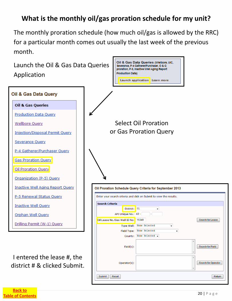
What is the monthly oil/gas proration schedule for my unit?
The monthly proration schedule (how much oil/gas is allowed by the RRC)
for a particular month comes out usually the last week of the previous
month.
Launch the Oil & Gas Data Queries
Application
Select Oil Proration or Gas Proration Query
I entered the lease #, the district # & clicked Submit.
Back to Table of Contents

21 | P a g e
Here are the Proration Query results for Lease 15349 in District 1.
Click on a well number for more
details.
Back to Table of Contents

22 | P a g e
Scroll down after selecting an individual well (Proration Schedule
by Well) and the W-10 at the bottom will show if the well has
been retested since the Initial Production (IP) test. You can tell it
is not the IP test based on the “Test Date:.”
Who is gathering/purchasing the oil/gas from my well (unit)?
1. Use Oil & Gas Data Queries Application
2. Select P-4 Gatherer/Purchaser Query
3. Enter the appropriate info & click Submit. a. Oil Well b. District 1
c. Lease 15349
Data I entered for this example
Back to Table of Contents

23 | P a g e
How can I find my operator number?
There are a number of ways this can be accomplished, I have found going
through the Oil & Gas Completion Query the easiest.
Back to Table of Contents

24 | P a g e
Enter the Operator name and click search…If there are no results enter
just a partial name and see what happens. Sometimes there are multiple
results for the same company. Then it becomes trial and error.
Below are some common Eagle Ford operators and their numbers:
Operator Name Operator # Operator Name Operator #
Abraxas Petroleum 003125 Marathon Oil EF LLC 525398
Burlington Resources O & G 109333 Matador Production 532993
Cabot Oil & Gas 121700 Murphy Expl. & Prod 594675
Carrizo (Eagle Ford) LLC 135316 Penn Virgina Oil & Gas 651780
Chesapeake Operating 147715 Petrohawk Operating 660146
Cheyenne Petroleum 148108 Pioneer Natural Res. 665748
Cinco Natural Resources 153474 Plains Exploration 667862
Comstock Oil & Gas 170040 Riley Exploration 712156
Crimson Exploration 190005 Rosetta Resources 728883
EOG Resources 253162 Sanchez Oil & Gas 747012
EP Energy E&P 253385 Southern Bay Operating 803494
Forest Oil 275740 Swift Energy 833348
Geosouthern Energy 301287 Talisman Energy 835506
Hess 381665 Valence Operating 881167
Hunt Oil 416330 XTO Energy 945936
Back to Table of Contents

25 | P a g e
Common Oil & Gas Abbreviations
API – American Petroleum Institute
BBL – Barrels of Oil
BOE – Barrels of Oil Equivalent (6 MCF of gas = 1 BBL = 1 BOE)
BOE Example:
Oil – 526 BBL, GAS – 1616 MCF
BOE = (1616/6) + 526 = 795 BOE
BOE/D – Barrels of Oil Equivalent per Day
BCF – Billion Cubic Feet
Brent Crude – Light sweet crude oil produced from the North Sea (not as light or sweet as WTI)
CF – Cubic Feet (1000 CF = 1 MCF)
GOR – Gas/Oil Ratio in CF/BBL
H2S – Hydrogen Sulfide
Heavy Crude Oil – Crude oil with an API gravity of 22.3 or less
Henry Hub – Pricing point for natural gas future contracts traded on NYMEX. It is a point on
the natural gas pipeline in Erath, Louisiana.
IP – Initial Production
Light Crude Oil – Crude oil with an API gravity higher than 31.1.
LLS – Louisiana Light Sweet
MCF – Thousand Cubic Feet
MMCF – Million Cubic Feet
NGL – Natural Gas Liquids
Sour – Oil & Gas with high sulfur content
Sweet – Oil & Gas with low sulfur content
WTI – West Texas Intermediate (crude benchmark)
Back to Table of Contents

26 | P a g e
Useful Links
Baker Hughes Weekly Rig Map
gis.bakerhughesdirect.com/RigCounts/default2.aspx
Daily Crude Oil Price Bulletins (Plains All American)
www.paalp.com/fw/main/default.asp?DocID=1363
Mineral Wise (good resource) www.mineralweb.com
Tax Issues for Mineral Owners (severance…depletion
allowance…etc.)
o Greenstein, Rogoff, Olson & Co., LLP, CPA's www.groco.com/readingroom/oil_gasdepletion.aspx
o R. King & Co. www.rkingco.com/mineral-owners/oil-and-gas-royalty-
income-taxes/
o IRS – Pub. 535 Chapter 9
www.irs.gov/publications/p535/ch09.html
Texas File (courthouse records covering much of Texas)
www.texasfile.com
Texas Unclaimed Property www.window.state.tx.us/up/
Disclaimer: There is NO implied endorsement to
any company linked or listed in this document.
This document is for informational purposes only.
Back to Table of Contents