rspo manual - gec
TRANSCRIPT
S U P P O R T E D B Y
Investing in rural people
RSP
O P
EA
TL
AN
D B
MP
MA
NU
AL V
OLU
ME
1
VO
LU
ME
1
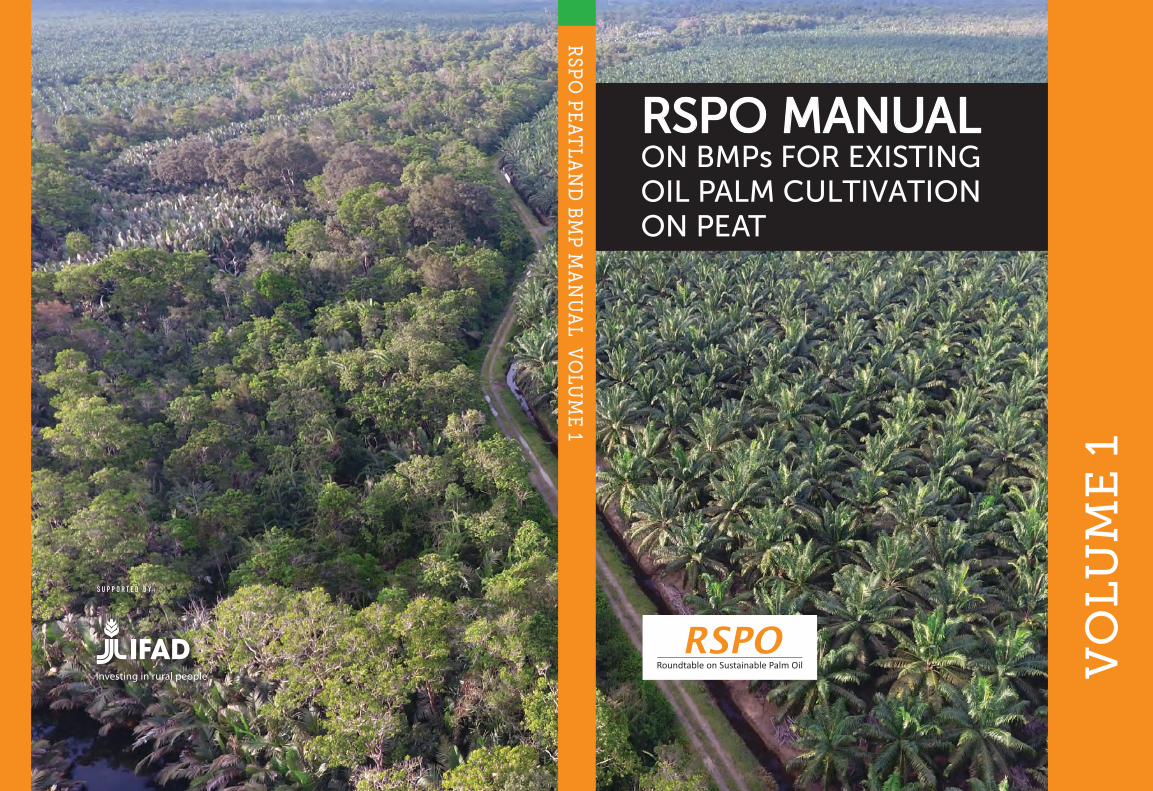
RSPO MANUAL ON BMPs FOR EXISTING OIL PALM CULTIVATION ON PEAT
Editorial team: Faizal Parish Joshua Mathews Lew Siew Yan (Serena) Muhamad Faizuddin Zainuddin Julia Lo Fui San
RSPO MANUAL ON BEST MANAGEMENT PRACTICES (BMPs) FOR EXISTING OIL PALM CULTIVATION ON PEAT
JUNE 2019
Disclaimer:The statements, technical information and recommendations contained in this Manual are based on best practice and experience and have been prepared by the members of the RSPO Peatland Working Group 2 (PLWG 2) established by decision of the RSPO Board of Governors. The guidance in this Manual does not necessarily reflect the views of the RSPO Secretariat or any of the individual contributors, sponsors and supporters of the process. The publication of this Manual does not constitute an endorsement by RSPO, the PLWG or any participants or supporters of the development of new oil palm plantations in peatland areas. Every effort has been made to make this Manual as complete and accurate as possible. However there may be omissions or errors, both typographical and in content and over time the contents may become superseded. Therefore this text should be used as a guide and not the sole basis for management of plantations on peatlands. The result of implementation of these practices may vary according to local conditions. Neither RSPO nor the PLWG or any contributors or supporters of the process can be held liable for the results of application of the guidance.
S U PP O R T ED BY:
Investing in rural people
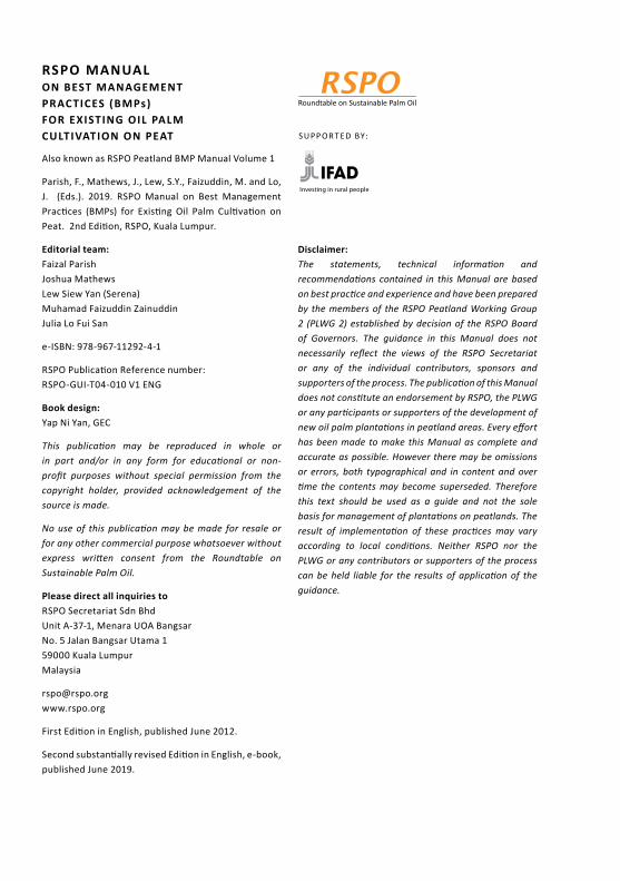
RSPO MANUAL ON BEST MANAGEMENT PRACTICES (BMPs) FOR EXISTING OIL PALM CULTIVATION ON PEAT
Also known as RSPO Peatland BMP Manual Volume 1
Parish, F., Mathews, J., Lew, S.Y., Faizuddin, M. and Lo, J. (Eds.). 2019. RSPO Manual on Best Management Practices (BMPs) for Existing Oil Palm Cultivation on Peat. 2nd Edition, RSPO, Kuala Lumpur.
Editorial team: Faizal Parish Joshua Mathews Lew Siew Yan (Serena) Muhamad Faizuddin Zainuddin Julia Lo Fui San
e-ISBN: 978-967-11292-4-1
RSPO Publication Reference number: RSPO-GUI-T04-010 V1 ENG
Book design: Yap Ni Yan, GEC
This publication may be reproduced in whole or in part and/or in any form for educational or non-profit purposes without special permission from the copyright holder, provided acknowledgement of the source is made.
No use of this publication may be made for resale or for any other commercial purpose whatsoever without express written consent from the Roundtable on Sustainable Palm Oil.
Please direct all inquiries to RSPO Secretariat Sdn Bhd Unit A-37-1, Menara UOA Bangsar No. 5 Jalan Bangsar Utama 1 59000 Kuala Lumpur Malaysia
[email protected] www.rspo.org
First Edition in English, published June 2012.
Second substantially revised Edition in English, e-book, published June 2019.
i
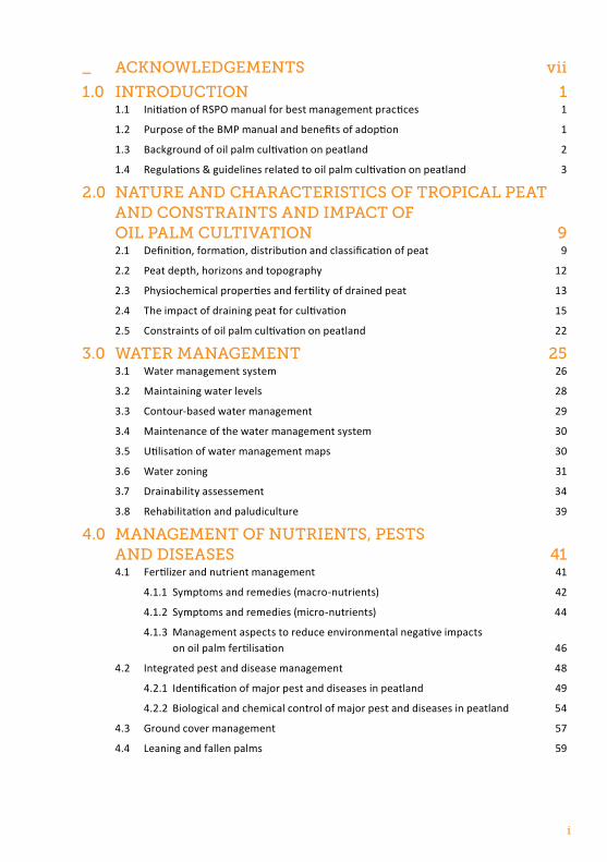
_ AcknowledgementS vii
1.0 IntroductIon 11.1 Initiation of RSPO manual for best management practices 1
1.2 Purpose of the BMP manual and benefits of adoption 1
1.3 Background of oil palm cultivation on peatland 2
1.4 Regulations & guidelines related to oil palm cultivation on peatland 3
2.0 nAture And chArActerIStIcS of tropIcAl peAt And conStrAIntS And ImpAct of oIl pAlm cultIvAtIon 92.1 Definition, formation, distribution and classification of peat 9
2.2 Peat depth, horizons and topography 12
2.3 Physiochemical properties and fertility of drained peat 13
2.4 The impact of draining peat for cultivation 15
2.5 Constraints of oil palm cultivation on peatland 22
3.0 wAter mAnAgement 253.1 Water management system 26
3.2 Maintaining water levels 28
3.3 Contour-based water management 29
3.4 Maintenance of the water management system 30
3.5 Utilisation of water management maps 30
3.6 Water zoning 31
3.7 Drainability assessement 34
3.8 Rehabilitation and paludiculture 39
4.0 mAnAgement of nutrIentS, peStS And dISeASeS 414.1 Fertilizer and nutrient management 41
4.1.1 Symptoms and remedies (macro-nutrients) 42
4.1.2 Symptoms and remedies (micro-nutrients) 44
4.1.3 Management aspects to reduce environmental negative impacts on oil palm fertilisation 46
4.2 Integrated pest and disease management 48
4.2.1 Identification of major pest and diseases in peatland 49
4.2.2 Biological and chemical control of major pest and diseases in peatland 54
4.3 Ground cover management 57
4.4 Leaning and fallen palms 59
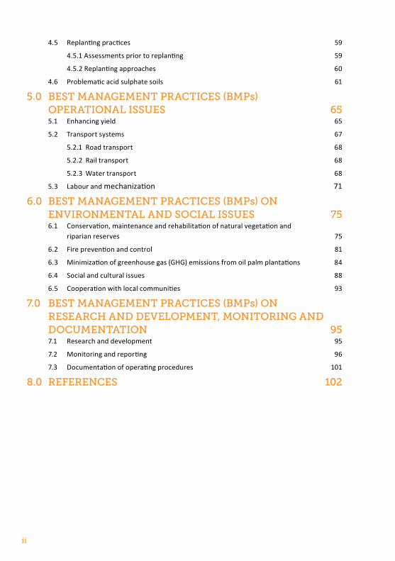
ii
4.5 Replanting practices 59
4.5.1 Assessments prior to replanting 59
4.5.2 Replanting approaches 60
4.6 Problematic acid sulphate soils 61
5.0 BeSt mAnAgement prActIceS (Bmps) operAtIonAl ISSueS 655.1 Enhancing yield 65
5.2 Transport systems 67
5.2.1 Road transport 68
5.2.2 Rail transport 68
5.2.3 Water transport 68
5.3 Labour and mechanization 71
6.0 BeSt mAnAgement prActIceS (Bmps) on envIronmentAl And SocIAl ISSueS 756.1 Conservation, maintenance and rehabilitation of natural vegetation and
riparian reserves 75
6.2 Fire prevention and control 81
6.3 Minimization of greenhouse gas (GHG) emissions from oil palm plantations 84
6.4 Social and cultural issues 88
6.5 Cooperation with local communities 93
7.0 BeSt mAnAgement prActIceS (Bmps) on reSeArch And development, monItorIng And documentAtIon 957.1 Research and development 95
7.2 Monitoring and reporting 96
7.3 Documentation of operating procedures 101
8.0 referenceS 102
iii
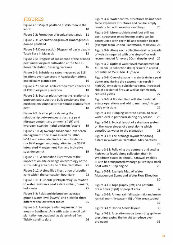
fIgureS Figure 2-1: Map of peatland distribution in the world 10
Figure 2-2: Formation of tropical peatlands 11
Figure 2-3: Schematic diagram of Ombrogenous domed peatland 11
Figure 2-4: Cross section Diagram of basin peat in Tasek Bera In Malaysia 12
Figure 2-5: Progress of subsidence of the drained peat under oil palm cultivation at the MPOB Research Station, Sessang, Sarawak 16
Figure 2-6: Subsidence rates measured at 218 locations over two years in Acacia plantations and oil palm plantations 16
Figure 2-7: Loss of Labile carbon from conversion of PSF to oil palm plantation 18
Figure 2-8: Scatter plot showing the relationship between peat substrate bulk density and the methane emission factor for smoke plumes from peat 18
Figure 2-9: Scatter plots showing the relationship between peat substrate peat nitrogen content and ammonia (left) and hydrogen cyanide (right) emission factors 19
Figure 2-10: A) Average subsidence over each management zone as measured by ISBAS InSAR and associated indicative subsidence risk B) Management designation in the NSPSF Integrated Management Plan and indicative subsidence risk 19
Figure 2-11: A simplified illustration of the impact of on-site drainage on hydrology of the surrounding area outside of the plantation 21
Figure 2-12: A simplified illustration of a buffer zone within the concession boundary 22
Figure 3-1: FFB yields (1998 planting) in relation to water levels in a peat estate in Riau, Sumatra, Indonesia 25
Figure 3-2: Relationship between average ground water level (AGWL) and Yield for three different shallow water tables 25
Figure 3-3: Average rainfall regime in three areas in Southeast Asia with extensive oil palm plantation on peatland, as determined from TRMM satellite data 26
Figure 3-4: Water control structures do not need to be expensive structures and can be simply constructed with wood or sand bags 26
Figure 3-5: More sophisticated (but still low cost) structures on collection drains can be constructed with earth fill and wooden boards (example from United Plantations, Malaysia) 26
Figure 3-6: Along each collection drain a cascade of weirs is required with one stop-off or weir recommended for every 20cm drop in level 27
Figure 3-7: Optimal water level management at 40-60 cm (in collection drain) results in a yield potential of 25-30 ton FFB/ha/yr 27
Figure 3-8: Over-drainage in main drain in a peat dome area during dry seasons may result in high CO2 emissions, subsidence rates, increased risk of accidental fires, as well as significantly reduced yields 27
Figure 3-9: A flooded field will also hinder all estate operations and add to methane/nitrogen oxide emissions 27
Figure 3-10: Pumping water to a canal to raise water level in particular during dry season 28
Figure 3-11: Typical layout of a drainage system on the lower slopes of a peat dome which contributes water to the plantation 28
Figure 3-12: The drainage layout for Adong estate in Woodman Plantation, Miri, Sarawak 29
Figure 3-13: Following the contours and setting high water levels along collection drain in Woodman estate in Bintulu, Sarawak enables FFB to be transported by barge pulled by a small boat with a 15hp engine 29
Figure 3-14: Example Map of Water Management Zones and Water Flow Direction 30
Figure 3-15: Topography (left) and potential drain flows (right) of project area 32
Figure 3-16: Annual rainfall pattern (L) and mean rainfall monthly pattern (R) of the area studied 32
Figure 3-17: Option A field layout 33
Figure 3-18: Alteration made to existing spillway crest (increasing the height to reduce over drainage) 33
iv
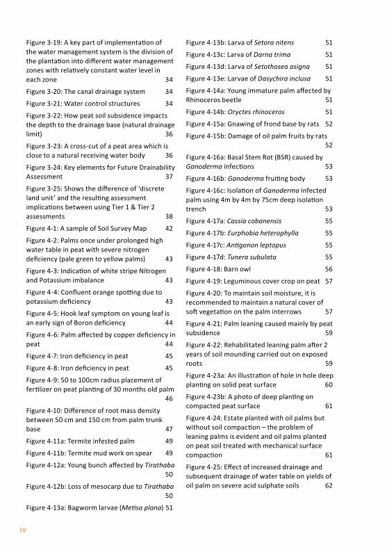
Figure 3-19: A key part of implementation of the water management system is the division of the plantation into different water management zones with relatively constant water level in each zone 34
Figure 3-20: The canal drainage system 34
Figure 3-21: Water control structures 34
Figure 3-22: How peat soil subsidence impacts the depth to the drainage base (natural drainage limit) 36
Figure 3-23: A cross-cut of a peat area which is close to a natural receiving water body 36
Figure 3-24: Key elements for Future Drainability Assessment 37
Figure 3-25: Shows the difference of ‘discrete land unit’ and the resulting assessment implications between using Tier 1 & Tier 2 assessments 38
Figure 4-1: A sample of Soil Survey Map 42
Figure 4-2: Palms once under prolonged high water table in peat with severe nitrogen deficiency (pale green to yellow palms) 43
Figure 4-3: Indication of white stripe Nitrogen and Potassium imbalance 43
Figure 4-4: Confluent orange spotting due to potassium deficiency 43
Figure 4-5: Hook leaf symptom on young leaf is an early sign of Boron deficiency 44
Figure 4-6: Palm affected by copper deficiency in peat 44
Figure 4-7: Iron deficiency in peat 45
Figure 4-8: Iron deficiency in peat 45
Figure 4-9: 50 to 100cm radius placement of fertilizer on peat planting of 30 months old palm 46
Figure 4-10: Difference of root mass density between 50 cm and 150 cm from palm trunk base 47
Figure 4-11a: Termite infested palm 49
Figure 4-11b: Termite mud work on spear 49
Figure 4-12a: Young bunch affected by Tirathaba 50
Figure 4-12b: Loss of mesocarp due to Tirathaba 50
Figure 4-13a: Bagworm larvae (Metisa plana) 51
Figure 4-13b: Larva of Setora nitens 51
Figure 4-13c: Larva of Darna trima 51
Figure 4-13d: Larva of Setothosea asigna 51
Figure 4-13e: Larvae of Dasychira inclusa 51
Figure 4-14a: Young immature palm affected by Rhinoceros beetle 51
Figure 4-14b: Oryctes rhinoceros 51
Figure 4-15a: Gnawing of frond base by rats 52
Figure 4-15b: Damage of oil palm fruits by rats 52
Figure 4-16a: Basal Stem Rot (BSR) caused by Ganoderma infections 53
Figure 4-16b: Ganoderma fruiting body 53
Figure 4-16c: Isolation of Ganoderma infected palm using 4m by 4m by 75cm deep isolation trench 53
Figure 4-17a: Cassia cobanensis 55
Figure 4-17b: Eurphobia heterophylla 55
Figure 4-17c: Antigonon leptopus 55
Figure 4-17d: Tunera subulata 55
Figure 4-18: Barn owl 56
Figure 4-19: Leguminous cover crop on peat 57
Figure 4-20: To maintain soil moisture, it is recommended to maintain a natural cover of soft vegetation on the palm interrows 57
Figure 4-21: Palm leaning caused mainly by peat subsidence 59
Figure 4-22: Rehabilitated leaning palm after 2 years of soil mounding carried out on exposed roots 59
Figure 4-23a: An illustration of hole in hole deep planting on solid peat surface 60
Figure 4-23b: A photo of deep planting on compacted peat surface 61
Figure 4-24: Estate planted with oil palms but without soil compaction – the problem of leaning palms is evident and oil palms planted on peat soil treated with mechanical surface compaction 61
Figure 4-25: Effect of increased drainage and subsequent drainage of water table on yields of oil palm on severe acid sulphate soils 62
v
Figure 4-26a: Acid sulphate soil excavated then used to increase planting bed resulting in serious oxidation and release of sulphuric acid and toxic metals resulting in no surface vegetation and poor oil palm growth 63
Figure 4-26b: Acid sulphate soil with yellowing due to oxidation of sulphur 63
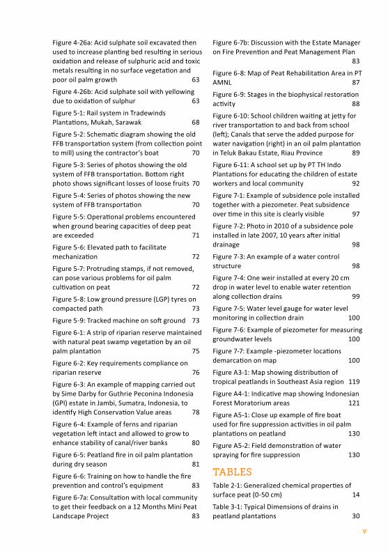
Figure 5-1: Rail system in Tradewinds Plantations, Mukah, Sarawak 68
Figure 5-2: Schematic diagram showing the old FFB transportation system (from collection point to mill) using the contractor’s boat 70
Figure 5-3: Series of photos showing the old system of FFB transportation. Bottom right photo shows significant losses of loose fruits 70
Figure 5-4: Series of photos showing the new system of FFB transportation 70
Figure 5-5: Operational problems encountered when ground bearing capacities of deep peat are exceeded 71
Figure 5-6: Elevated path to facilitate mechanization 72
Figure 5-7: Protruding stamps, if not removed, can pose various problems for oil palm cultivation on peat 72
Figure 5-8: Low ground pressure (LGP) tyres on compacted path 73
Figure 5-9: Tracked machine on soft ground 73
Figure 6-1: A strip of riparian reserve maintained with natural peat swamp vegetation by an oil palm plantation 75
Figure 6-2: Key requirements compliance on riparian reserve 76
Figure 6-3: An example of mapping carried out by Sime Darby for Guthrie Peconina Indonesia (GPI) estate in Jambi, Sumatra, Indonesia, to identify High Conservation Value areas 78
Figure 6-4: Example of ferns and riparian vegetation left intact and allowed to grow to enhance stability of canal/river banks 80
Figure 6-5: Peatland fire in oil palm plantation during dry season 81
Figure 6-6: Training on how to handle the fire prevention and control’s equipment 83
Figure 6-7a: Consultation with local community to get their feedback on a 12 Months Mini Peat Landscape Project 83
Figure 6-7b: Discussion with the Estate Manager on Fire Prevention and Peat Management Plan 83
Figure 6-8: Map of Peat Rehabilitation Area in PT AMNL 87
Figure 6-9: Stages in the biophysical restoration activity 88
Figure 6-10: School children waiting at jetty for river transportation to and back from school (left); Canals that serve the added purpose for water navigation (right) in an oil palm plantation in Teluk Bakau Estate, Riau Province 89
Figure 6-11: A school set up by PT TH Indo Plantations for educating the children of estate workers and local community 92
Figure 7-1: Example of subsidence pole installed together with a piezometer. Peat subsidence over time in this site is clearly visible 97
Figure 7-2: Photo in 2010 of a subsidence pole installed in late 2007, 10 years after initial drainage 98
Figure 7-3: An example of a water control structure 98
Figure 7-4: One weir installed at every 20 cm drop in water level to enable water retention along collection drains 99
Figure 7-5: Water level gauge for water level monitoring in collection drain 100
Figure 7-6: Example of piezometer for measuring groundwater levels 100
Figure 7-7: Example -piezometer locations demarcation on map 100
Figure A3-1: Map showing distribution of tropical peatlands in Southeast Asia region 119
Figure A4-1: Indicative map showing Indonesian Forest Moratorium areas 121
Figure A5-1: Close up example of fire boat used for fire suppression activities in oil palm plantations on peatland 130
Figure A5-2: Field demonstration of water spraying for fire suppression 130
tABleSTable 2-1: Generalized chemical properties of surface peat (0-50 cm) 14
Table 3-1: Typical Dimensions of drains in peatland plantations 30
vi
Table 4-1: Alternative Herbicides to Paraquat Di Chloride used in controlling Stenochalena palsuris 59
Table 5-1: Comparison of turnaround time and manpower requirements for FFB transportation between old and new systems for FFB transportation 71
Table 6-1: River reserve width requirements 76
Table 6-2: Some of the main emissions and sequestrations / credit from plantation and mill calculated in Palm GHG 85
Table 6-3: BMPs implemented by GAR that reduce GHG emissions 87
Table 7-1: Data of peat subsidence (cm/year) in mature (sapric) peat of 1-3 m depth from 2008 to 2010 at 8 different sites in PT TH Indo Plantations, Riau, Indonesia, with good water management systems 98
Table A3-1: Area of peatlands in SE Asia, by country 119
Table A3-2: Estimates of major peat swamp forest areas (in hectares) in SE Asia 119
Table A3-3: Best estimates of peat area and mean thickness in tropical Southeast Asia from various sources 120
Table A3-4A: Oil palm on peat in 2009 in Malaysia 120
Table A3-4B: Oil palm on peat for Indonesia and Malaysia 120
Table A3-5: Area of Peatland Ecosystems Functions in Indonesia 120
BoXeSBOX 1: Case Study: Measurements of peat subsidence extracted from “Experiences in Peat Development for Oil Palm Planting in the MPOB Research Station at Sessang, Sarawak, Malaysia” 15
BOX 2: Case Study: Selangor Peat Swamp Forest Malaysia-Subsidence, Fire and GHG Assessment 18
BOX 3: Case Study: Water Management Study of PT Bhumireksa Nusa Sejati, Sumatra, Indonesia 31
BOX 4: RSPO Drainability Assessment Procedure 37
BOX 5: Limiting factors of oil palm cultivation on peat soils and recommendations for yield enhancement 65
BOX 6: Case Study: harvesting and transportation of FFB in peat soils at PT Bhumireksa Nusa Sejati, Sumatera, Indonesia 69
BOX 7: Guidance notes on Landscape Approach 77
BOX 8: Partnership Programme with Local Community in Preventing Fire and Managing Peat Ecosystem by IOI Group 83
BOX 9: RSPO’s GHG monitoring and reporting requirement for existing plantation on Peat 85
BOX 10: Peat Rehabilitation Program and other BMPs to Reduce GHG Emissions of Golden Agri Resources 87
BOX 11: Dispute Settlement Facility 90
BOX 12: Case Study on social and cultural issues relating to cultivation of oil palm on peat at PT TH Indo Plantations 91
BOX 13: Case Study – Peat subsidence in shallow, mature (sapric) peat at PT TH Indo Plantations, Riau, Indonesia 97
BOX 14: Explanation of abbreviations used in ISPO Criteria 123
BOX 15: Guidelines for the Implementation of the ASEAN Policy on Zero Burning 131
AnneXeSAnnex 1: Glossary and abbreviations 110
Annex 2: Summary TOR for the Second RSPO Peatland Working Group (PLWG -2) 112
Annex 3: Cultivation on Peat-RSPO Peat Audit Guidance (P&C 2018) 114
Annex 4: Distribution peatland in Southeast Asia 119
Annex 5: Relevant national regulations and requirements on oil palm plantation on peat 121
Annex 6: Definition of peatland 127
Annex 7: Fire prevention and control 128
vii
ACkNOwLEdGEMENTSRSPO would like to thank all the RSPO Peatland Working Group 2 (PLWG2) members, Co-Chairs (Faizal Parish of Global Environment Centre (GEC and Joshua Mathews of Bumitama Gunajaya Agro (BGA) Group) and the contributions from the RSPO and industry members for the successful completion of the review and revision of the RSPO MANUAL ON BEST MANAGEMENT PRACTICES (BMPs) FOR EXISTING OIL PALM CULTIVATION ON PEAT.
Special appreciations are given to Dr Joshua Mathews and Dr Sim Choon Cheak who provided substantial inputs for Chapter 4 on nutrients, pests and diseases; and the Global Environment Centre who facilitated the overall review and updating process and revised the information in other existing chapters with the inputs from the PLWG and other contributors. Extended appreciation is given to PT BNS (Minamas of Sime Darby Group), Adong Estate (Woodman Plantation), and Sungai Balim Estate (Sarawak Oil Palms Berhad) – for hosting the field visits during the preparation and review period. Significant contributions were made by all those that attended the consultations in Bali, Indonesia in November 2017 and Miri, Sarawak, Malaysia in January 2018. Important inputs and comments were made by many during the public consultation period in particular, the Malaysian Palm Oil Board (MPOB) and experts – Dr Susan Page, Dr Stephanie Evers, and Casey Ng. The photographs were mainly provided by Bumitama Gunajaya Agro (BGA) Group, Asian Agri, Woodman Plantations, IOI Plantations and Global Environment Centre. New case studies and other inputs were provided by Golden Agri Resources (GAR), IOI Plantations and Tropical Catchments Research Initiative (TROCARI).
Funding to support preparation and printing of this Peatland BMP Manual has been provided by the RSPO as well as a project funded by the International Fund For Agriculture Development (IFAD) – Technical Assistance and Knowledge Exchange for Sustainable Management of Peatland Ecosystems in Malaysia (TAKE-SMPEM) and implemented by GEC.
viii
11.0 INTRODUCTION
1.0 INTROdUCTIONThis chapter provides background information including the initiation of the Manual, purpose of the Manual along with benefits of Best Management Practices (BMP) adoption. There is also general background of oil palm cultivation on peatland focusing on Indonesia and Malaysia. This chapter also describes the regulations and guidelines related to oil palm cultivation on peatland in the form of the RSPO’s Principles and Criteria (P&C) and regulations from selected countries. A glossary for this manual is given in Annex 1.
1.1 InItIAtIon of rSpo mAnuAl for BeSt mAnAgement prActIceS
This Manual was initially prepared in 2010-2012 in response to the decision by the RSPO General Assembly (GA) in November 2009 to provide guidance to improve yields in existing oil palm cultivation on peat and to address issues related to greenhouse gas (GHG) emissions, subsidence and other impacts that affect the potential sustainability of the oil palm cultivation on peatlands. The Manual was prepared through a consultative process facilitated by the RSPO Peatland Working Group (PLWG), which was established in April 2010 in response to the GA decision.
The Manual has now been updated in 2017-2019 to incorporate new information, methods and practices under the guidance of the Second RSPO PLWG (PLWG-2) formed in March 2017 (See Annex 2). The PLWG-2 updated and collated experiences from RSPO members and non-member companies, visited oil palm plantations and smallholders on peat as well as organized public stakeholder consultations in Bali, Indonesia and Miri, Sarawak, Malaysia to gather input for the revision of this Manual. Preparation of the main drafts was facilitated by the Global Environment Centre (GEC) but amendments and contributions were received from a broad range of other PLWG members and external parties. Consultations were organized with stakeholder in Indonesia and Malaysia and drafts were circulated for comment to a range of stakeholders and specialist reviewers.
1.2 purpoSe of the Bmp mAnuAl And BenefItS of AdoptIon
The objective of this Manual is to provide a set of practical guidance on BMPs that are important for enhancing the management of existing oil palm cultivation on tropical peat while at the same time reducing environmental impacts especially GHG emissions and subsidence. This BMP Manual is not only applicable to existing large plantations, also applicable to medium and small-scale cultivation of oil palm on peat.
This Manual draws on more than 35 years of experiences for cultivation of oil palm on peatlands in Southeast Asia. It also makes use of the recent research on GHG emissions and water management. It refers to existing national regulations and guidelines especially from Malaysia and Indonesia – the two countries with the largest areas of oil palm cultivated on peatland. This second edition includes information on peatlands in other countries such as Papua New Guinea, and from Africa, Latin America, including the Congo basin and Amazonia.
This Manual is a positive step taken by RSPO to guide its members, particularly producers in responding to stakeholder concerns on peatland development. It will help promote the implementation of BMPs and reduce negative impacts related to oil palm cultivation on peat. It is also hoped that readers of this Manual will better understand the constraints of oil palm cultivation on peat and the implications such as subsidence and GHG emissions. Implementation of the BMPs will reduce subsidence but will not stop it, leading over time to long-
2 RSPO MANUAL ON BEST MANAGEMENT PRACTICES (BMPs) FOR EXISTING OIL PALM CULTIVATION ON PEAT
term drainability problems which may limit the life span of the plantations. Therefore in the medium to long term (depending on local hydrological circumstances), alternative uses will need to be identified for many of the areas now developed as plantations. Guidance for phasing out of production in peatlands is given in the separate RSPO Drainability Assessment Procedure (RSPO, 2019).
Although the existing cultivation of oil palms on tropical peat has brought about economic and social benefits in Indonesia and Malaysia in the past 30-35 years, all the RSPO growers companies have now adopted (through the 2018 RSPO Principles and Criteria) the policy of not planting any new areas on peat to avoid any negative environmental impacts. However care and application of the right practices are still needed in existing plantations to minimize GHG emissions and potential impacts to the environment. The RSPO Principle on commitment for continual improvement should always be emphasized. The smallholder sector will need more technical guidance and financial support to be able to implement the BMPs effectively.
This BMP Manual on Existing Oil Palm Cultivation on Peat is complemented by a second BMP Manual for Management and Rehabilitation of Peatlands. The second manual deals with a range of key issues including introduction to peatland ecosystems as well as management and rehabilitation of peat swamp forests and degraded peat sites. It also deals with the landscape approach, conservation and buffer zones, connectivity and water management.
For the purpose of audit compliance to the RSPO P&C 2018, a separate Audit Guidance Document has been prepared and a copy is included as Annex 3.
1.3 BAckground of oIl pAlm cultIvAtIon on peAtlAnd
Over the last 35 years, oil palm cultivation has rapidly expanded in Southeast Asia (particularly Indonesia and Malaysia) and currently covers about 17.6 million hectares (ha). Initially oil palm cultivation focused on mineral soils but as plantation land became scarce, peat soils, which were considered less suitable, were also converted. There was also conversion of rubber plantation (some on peat soil) to oil palm as a means to control the oversupply of rubber and manage its price volatility. However, partly due to poor experience with initial cultivation, plantations on peat did not produce good yields and estates were often waterlogged and trees easily susceptible to disease. These problems were largely due to the lack of understanding of the structure and hydrology of these peatlands.
It was not until 1986, the pioneering work of United Plantations in Peninsular Malaysia (Gurmit et al., 1986) with its introduction to water control and nutritional management which significantly increased the potential for successful cultivation of oil palms on peat.
In the past 25 years, a combination of development of new technologies for water management and agronomy for cultivating oil palm on peat as well as government planning decisions in some regions has led to the expansion of oil palm on peat. Currently it is estimated that there are more than 3.1 million ha of oil palm cultivated on peat representing about 17% of oil palm in the Southeast Asia region and covering about 12% of the region’s peatlands. As of 2015, 1,059,510 ha of peatlands in Malaysia (Sarawak – 717,830 ha, Peninsular – 275,680 ha, Sabah – 66,000 ha) (Miettinen et al., 2016) and about 2,046,580 ha in Indonesia (Sumatra – 1,315,830 ha and Kalimantan – 730,750) (Miettinen et al., 2016) had been developed for oil palm cultivation. For more details on distribution of peatlands in Southeast Asia and oil palm developments on peatland, see Annex 4.
31.0 INTRODUCTION
Peat soils are diverse in physical and chemical properties and not all are productive and easy to manage. Considerable skill, planning and implementation of BMPs as well as knowledge and understanding of peat are required to reduce some of the impacts caused by oil palm cultivation on peat while enhancing yields. Long term environmental considerations and social aspects need to be taken into account in peat- planting especially minimizing subsidence and reducing emissions of GHG.
Plantation companies with peatland development however reported that not all their peat estates are yielding equally. Especially low yields have been recorded on the more woody peat in Sarawak. The actual fresh fruit bunches (FFB) yields of prime age oil palms on deep peat are very contrasting, ranging from about 30 to less than 15 metric tons per ha per year (mt/ha/year). United Plantations showed that their early plantings on deep peat during the 1960s yielded only an average of 12.9 mt/ha over a 12-year period (5th to 16th year of planting). The main factors affecting this high yield variation are peat type, land preparation, planting techniques, fertilization, water management as well as effective pest and disease control. This had changed with improved technology and methods; higher yields had been reported e.g. average of 20t/ ha (8th to 10th year of planting) (Pupathy, 2018), 19t/ ha (9th -10th year of planting) (Mathews, 2018).
A proper drainage system with effective water management structures are crucial to maximize oil palm yield on peat and also to minimize GHG emissions and peat subsidence, which is vital for prolonging the economic life span of the developed peat.
Cultivating oil palm on peatland requires significantly more effort and associated costs as compared to planting oil palm on mineral soils. Increased operational costs for oil palm cultivation on peatlands are a result of additional land preparation works, road maintenance and water management. The challenges for planting oil palm on peat was highlighted by Tan Sri Datuk Dr Yusof Basiron, former CEO of the Malaysian Palm Oil Council (MPOC), who said “The planting of oil palm on peat demands significantly more intense efforts in terms of higher costs and increased management inputs. It is not a planter’s preference to plant oil palm on peat” (Liew, 2010).
1.4 regulAtIonS & guIdelIneS relAted to oIl pAlm cultIvAtIon on peAtlAnd
The following are various regulations and guidelines related to oil palm cultivation on peatland. They consist of:
• RSPO Principles & Criteria (P&C), associated indicators and guidance from Indonesia, Malaysia and Papua New Guinea National Interpretation documents that cover oil palm cultivation on peatland and water management issues
• Indonesian regulations on peatlands and sustainable palm oil
• Malaysian regulations on environmentally sensitive areas and sustainable palm oil
rSpo prIncIpleS & crIterIA (p&c) 2013 And 2018Within RSPO’s P&C (2013), there already exist some specific criteria and national interpretation verifiers related to the cultivation on peatland. These have been built on and expanded in the RSPO P&C 2018. These provisions form the reference point or key standard of this Manual. Other criteria and indicators consider different elements such as legal obligations, workers and community rights, avoiding deforestation etc.
4 RSPO MANUAL ON BEST MANAGEMENT PRACTICES (BMPs) FOR EXISTING OIL PALM CULTIVATION ON PEAT
The key elements included in the 2013 P&C related to oil palm cultivation on peat are linked to the following criteria:
CRITERION 4.3 Practices minimise and control erosion and degradation of soils.
CRITERION 4.4 Practices maintain the quality and availability of surface and ground water.
CRITERION 5.1 Aspects of plantation and mill management, including replanting, that have environmental impacts are identified, and plans to mitigate the negative impacts and promote the positive ones are made, implemented and monitored, to demonstrate continuous improvement.
CRITERION 5.6 Plans to reduce pollution and emissions, including greenhouse gases, are developed, implemented and monitored.
In the RSPO 2018 P&C adopted in November 2018 – peatland management is mainly incorporated in a new specific criterion as follows:
Criterion 7.7 No new planting on peat, regardless of depth after 15 November 2018 and all peatlands are managed responsibly.
IndIcAtorS7.7.1 (C) There is no new planting on peat regardless of depth after 15 November 2018 in existing
and new development areas.
7.7.2 Areas of peat within the managed areas are inventoried, documented and reported (effective from 15 November 2018) to RSPO Secretariat.
7.7.3 (C) Subsidence of peat is monitored, documented and minimised.
7.7.4 (C) A documented water and ground cover management programme is in place.
7.7.5 (C) For plantations planted on peat, drainability assessments are conducted following the RSPO Drainability Assessment Guidelines, or other RSPO recognised methods, at least five years prior to replanting. The assessment result is used to set the timeframe for future replanting, as well as for phasing out of oil palm cultivation at least 40 years, or two cycles, whichever is greater, before reaching the natural gravity drainability limit for peat. When oil palm is phased out, it should be replaced with crops suitable for a higher water table (paludiculture) or rehabilitated with natural vegetation.
7.7.6 (C) All existing plantings on peat are managed according to the ‘RSPO Manual on Best Management Practices (BMPs) for existing oil palm cultivation on peat’, version 2 (2018) and associated audit guidance.
7.7.7 (C) All areas of unplanted and set-aside peatlands in the managed area (regardless of depth) are protected as “peatland conservation areas”; new drainage, road building and power lines by the unit of certification on peat soils is prohibited; peatlands are managed in accordance with the ‘RSPO BMPs for Management and Rehabilitation of Natural Vegetation Associated with Oil Palm Cultivation on Peat’, version 2 (2018)* and associated audit guidance.
*second edition published in 2019
51.0 INTRODUCTION
IndoneSIAn regulAtIonSDevelopments of oil palm on peatlands in Indonesia need to take into consideration the following regulations from the Indonesian Government:
• PP 71/ 2014 as revised by PP 57/2016 in December 2016 sets out the requirements for protection and management of peatland ecosystems in Indonesia. This regulation: i) bans all new land clearing and canal building on peatland; ii) sets a lower limit for the peatland water table at 0.4m below the ground surface; iii) makes it illegal for both companies and local communities to burn peatland prior to development; and iv) requires regular monitoring of water levels and status of peatlands as well as reporting to the local and central government.
With the issuance of PP71/2014 and PP 57/2016, Indonesian peatlands have been subdivided into more than 300 Peatland Hydrological Units (PHUs). At least 30% of each PHU must be conserved including areas of remaining quality peat swamp forests, and all areas over 3m depth. This means that a company operating in a peatland may be obliged to set aside an area for conservation (Chapter 9, Clause3, 4(a)).
Further sub-regulations detail out the requirements for inventory and mapping, ecosystem function assessment as well as water table monitoring and management as follows:
• Peraturan Menteri Linkungan Hidup dan Kehutanan Nomor P.14/MENLHK/SETJEN/KUM.1/2/2017 tentang Tata Cara Inventarisasi dan Penetapan Fungsi Ekosistem Gambut (P.14/2017 on Procedure for Inventory and Determination of Peat Ecosystem Functions)
• Peraturan Menteri Linkungan Hidup dan Kehutanan Nomor P.15/MENLHK/SETJEN/KUM.1/2/2017 tentang Tata Cara Pengukuran Muka Air Tanah di Titik Penaatan Ekosistem Gambut (P.15/2017 on Procedures for Measuring Groundwater Levels in Peat Ecosystem at Designated Monitoring Points)
• Peraturan Menteri Linkungan Hidup dan Kehutanan Nomor P.16/MENLHK/SETJEN/KUM.1/2/2017 tentang Pedoman Teknis Pemulihan Fungsi Ekosistem Gambut (P.16/2017 on Technical Guidelines for Functions Recovery of Peat Ecosystem)
Detailed maps showing PHUs and areas to be conserved are included in the following decisions:
• Keputusan Menteri Lingkungan Hidup Dan Kehutanan Republik Indonesia Nomor SK.129/Menlhk/Setjen/Pkl.0/2/2017 Tentang Penetapan Peta Kesatuan Hidrologis Gambut Nasional (SK129/2017 on Determination of National Peatland Hydrological Units Map)
• Keputusan Menteri Lingkungan Hidup Dan Kehutanan Republik Indonesia Nomor SK.130/Menlhk/Setjen/Pkl.0/2/2017 Tentang Penetapan Peta Fungsi Ekosistem Gambut Nasional (SK130/2017 on Determination of Map of National Peatland Ecosystem Functions)
Indonesia Forest Moratorium: The Indonesian President made an official Indonesia Forest Moratorium starting on 20 May 2011. Under this moratorium, central and local governments are not allowed to issue new permits for conversion of designated primary forests or peatlands in Indonesia as specified in a map attached to the regulation (and subsequently revised on a regular basis). The moratorium was extended for the third time in May 2017 for another two years.
6 RSPO MANUAL ON BEST MANAGEMENT PRACTICES (BMPs) FOR EXISTING OIL PALM CULTIVATION ON PEAT
Other regulations:• Presidential Decree No. 32/1990 – This Decree prohibits the use of peatlands if the peat thickness
is more than 3m or if the peatland is on conservation or protection forest land. Where existing plantation licenses or pending applications lie on peat soils with a depth greater than 3m, such licenses could be revoked under this provision. This Decree is reinforced by PP71/2014 and PP57/2016 mentioned above.
• Ministry of Agriculture Decree No. 14/2009 gives further guidance on development on peatlands. It states that peatland overlying acid sulfate soils and quartz sands may not be developed. Other provisions are largely subsumed under PP71/2014 as amended by PP57/2016.
Indonesian Sustainable Palm Oil (ISPO) requirements: Under the Ministry of Agriculture Decree No. 19/2011, ISPO criteria specifically relevant to cultivation of oil palm on peatland are to be implemented:
CRITERION 2.1.5 Plantings on peatland – Planting oil palm on peatlands can be done by observing characteristics of peat so as to not cause damage to environmental functions
CRITERION 3.6 Plantings Mitigation of Greenhouse Gas (GHG) Emissions - Management of the plantation business must identify the source of GHG emissions. Management measures include water management in peatlands.
ISPO may need to be updated to bring it in line with more recent regulations such as PP71/2014 and PP57/2016.
mAlAYSIAn regulAtIonSPeat swamp forests are recognised by the Government of Malaysia as an Environmentally Sensitive Area (ESA) under Section 6B of the Town and Country Planning 1976 (ACT 172) and in the First to Third National Physical Plan (NPP1-3). Every State Government is also required to comply with the requirements of the NPP by incorporating ESAs into state structure plans and local plans. The requirements for Environmental Impact Assessment (EIA) under the Environment Quality Act (1972) have been recently updated in the EIA Order 2015. This has emphasized the importance of ESAs and has lowered the size of a peatland area where an EIA is mandatory. See Annex 5 for details.
Malaysia had adopted the National Action Plan for Peatlands (NAPP) in 2011. It provides a set of guidelines on peatland management in Malaysia. The Government of Malaysia also has adopted the National Policy on Biological Diversity 2016-2025 of which included a Key Indicator 7.3 that aims to rehabilitate 10,000 ha of degraded peat swamp forests by 2025.
Malaysia government had introduced Malaysian Sustainable Palm Oil (MSPO) Standard in 2013. Implementation of the MSPO certification scheme started on 1st January 2015, with a target of mandatory certification for both plantations and smallholders by 31st December 2019.
MSPO REquIREMENTS INCludE ThE fOllOwINg CRITERIa uNdER PRINCIPlE 7New planting and replanting on peatlands can be developed as per MPOB’s guidelines and industry’s best practices.

2.0 NATURE AND CHARACTERISTICS OF TROPICAL PEAT AND CONSTRAINTS AND IMPACT OF OIL PALM CULTIVATION 7
other countrIeSExtensive peatlands are found in other regions of the world especially in the Congo and Amazon basins as well as Papua New Guinea. There are few if any specific regulations in these countries on the management of peatlands. However peatland management may be addressed in more general regulations on the environment or in policies or strategies related to wetlands. The Democratic Republic of Congo, for example, imposed a forest moratorium on new industrial logging titles since 2002 (which covers peatland forests). However, the government had started to lift the moratorium in 2018.

RSPO MANUAL ON BEST MANAGEMENT PRACTICES (BMPs) FOR EXISTING OIL PALM CULTIVATION ON PEAT8
2.0 NATURE AND CHARACTERISTICS OF TROPICAL PEAT AND CONSTRAINTS AND IMPACT OF OIL PALM CULTIVATION 9
2.0 NATURE ANd CHARACTERISTICS OF TROPICAL PEAT ANd CONSTRAINTS ANd IMPACT OF OIL PALM CULTIVATION
This chapter provides basic information on the nature and characteristics of tropical peat including the following topics: definition, formation, distribution and classification of peat, peat depth, horizons and topography, physiochemical properties and fertility of drained peat. The impacts of drainage such as subsidence, GHG emissions, increased fire risks and off-site impacts are also highlighted as well as the constraints of oil palm cultivation on peat.
2.1 defInItIon, formAtIon, dIStrIButIon And clASSIfIcAtIon of peAt
defInItIonA peatland is an area with a layer of naturally accumulated organic material. Most tropical peat soils belong to the soil order Histosols and the sub-orders Fibrists and Hemists. Peat soils consist of partly decomposed biomass and develop when the rate of biomass accumulation from vegetation is greater than the rate of decomposition. The rate of decomposition is reduced due to the presence of a permanently high water table that prevents the aerobic decomposition of plant debris (Andriesse, 1988; Driessen, 1978). Soils are classified as peat soils when they reach an accepted threshold (e.g., host-country, FAO or IPCC) for the depth of the peat layer and the percentage of organic material composition. Some classifications adopt a minimum organic matter percentage of 35% in a minimum accumulated organic layer of 30cm, others specify an organic content of 65% while some require an accumulation of at least 40 or even 50cm to qualify.
RSPO P&C (2018) has adopted the following definition of peat effective 15 November 2018 as follows:
Tropical peat soils are soils with cumulative organic layer(s) comprising more than half of the upper 80 cm or 100 cm of the soil surface containing 35% or more of organic matter (35% or more Loss on Ignition) or 18% or more organic carbon.
This definition is derived from globally accepted definitions (USDA and FAO) for histosols.
Note: for management of existing plantations in Malaysia and Indonesia, a narrower definition has been used, based on national regulations: namely soil with an organic layer of more than 50cm in the top 100 cm containing more than 65% organic matter.
Further details on definition are given in Annex 6.
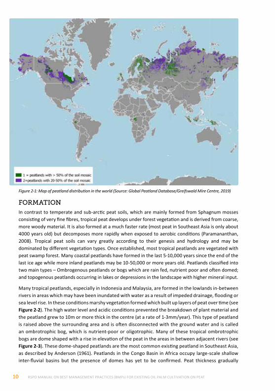
dIStrIButIonTropical peatlands are estimated to cover about 60 million hectares. Peatlands occur in the following regions: Southeast Asia (24 million ha, 40%), followed by Africa (20 million ha; 33%), South America (10.7 million ha; 18%), Central America and the Caribbean (2.3 million ha; 4%), the Pacific region (2 million ha; 3%) and Asia (other countries) (600,000ha; 1%) (updated from Page et al., 2011). The area of peatlands in Africa increased recently with the documentation of the largest known tropical peatland complex covering 14.55 million ha in the Cuvette Centrale Region of the Congo Basin (Dargie et al., 2017)
RSPO MANUAL ON BEST MANAGEMENT PRACTICES (BMPs) FOR EXISTING OIL PALM CULTIVATION ON PEAT10
Figure 2-1: Map of peatland distribution in the world (Source: Global Peatland Database/Greifswald Mire Centre, 2019)
formAtIonIn contrast to temperate and sub-arctic peat soils, which are mainly formed from Sphagnum mosses consisting of very fine fibres, tropical peat develops under forest vegetation and is derived from coarse, more woody material. It is also formed at a much faster rate (most peat in Southeast Asia is only about 4000 years old) but decomposes more rapidly when exposed to aerobic conditions (Paramananthan, 2008). Tropical peat soils can vary greatly according to their genesis and hydrology and may be dominated by different vegetation types. Once established, most tropical peatlands are vegetated with peat swamp forest. Many coastal peatlands have formed in the last 5-10,000 years since the end of the last ice age while more inland peatlands may be 10-50,000 or more years old. Peatlands classified into two main types – Ombrogenous peatlands or bogs which are rain fed, nutrient poor and often domed; and topogenous peatlands occurring in lakes or depressions in the landscape with higher mineral input.
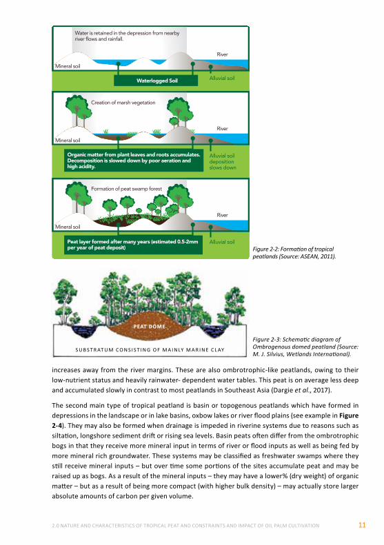
Many tropical peatlands, especially in Indonesia and Malaysia, are formed in the lowlands in-between rivers in areas which may have been inundated with water as a result of impeded drainage, flooding or sea level rise. In these conditions marshy vegetation formed which built up layers of peat over time (see Figure 2-2). The high water level and acidic conditions prevented the breakdown of plant material and the peatland grew to 10m or more thick in the centre (at a rate of 1-3mm/year). This type of peatland is raised above the surrounding area and is often disconnected with the ground water and is called an ombrotrophic bog, which is nutrient-poor or oligotrophic. Many of these tropical ombrotrophic bogs are dome shaped with a rise in elevation of the peat in the areas in between adjacent rivers (see Figure 2-3). These dome-shaped peatlands are the most common existing peatland in Southeast Asia, as described by Anderson (1961). Peatlands in the Congo Basin in Africa occupy large-scale shallow inter-fluvial basins but the presence of domes has yet to be confirmed. Peat thickness gradually
2.0 NATURE AND CHARACTERISTICS OF TROPICAL PEAT AND CONSTRAINTS AND IMPACT OF OIL PALM CULTIVATION 11
increases away from the river margins. These are also ombrotrophic-like peatlands, owing to their low-nutrient status and heavily rainwater- dependent water tables. This peat is on average less deep and accumulated slowly in contrast to most peatlands in Southeast Asia (Dargie et al., 2017).
The second main type of tropical peatland is basin or topogenous peatlands which have formed in depressions in the landscape or in lake basins, oxbow lakes or river flood plains (see example in Figure 2-4). They may also be formed when drainage is impeded in riverine systems due to reasons such as siltation, longshore sediment drift or rising sea levels. Basin peats often differ from the ombrotrophic bogs in that they receive more mineral input in terms of river or flood inputs as well as being fed by more mineral rich groundwater. These systems may be classified as freshwater swamps where they still receive mineral inputs – but over time some portions of the sites accumulate peat and may be raised up as bogs. As a result of the mineral inputs – they may have a lower% (dry weight) of organic matter – but as a result of being more compact (with higher bulk density) – may actually store larger absolute amounts of carbon per given volume.
PEAT DOME
S U B S T R AT U M C O N S I S T I N G O F M A I N LY M A R I N E C L AY
Water is retained in the depression from nearbyriver �ows and rainfall.
Alluvial soil
Alluvial soildepositionslows down
Alluvial soil
Waterlogged Soil
Organic matter from plant leaves and roots accumulates. Decomposition is slowed down by poor aeration andhigh acidity.
Peat layer formed after many years (estimated 0.5-2mmper year of peat deposit)
River
Mineral soil
River
Mineral soil
River
Mineral soil
Creation of marsh vegetation
Formation of peat swamp forest
Figure 2-2: Formation of tropical peatlands (Source: ASEAN, 2011).
Figure 2-3: Schematic diagram of Ombrogenous domed peatland (Source: M. J. Silvius, Wetlands International).
RSPO MANUAL ON BEST MANAGEMENT PRACTICES (BMPs) FOR EXISTING OIL PALM CULTIVATION ON PEAT12
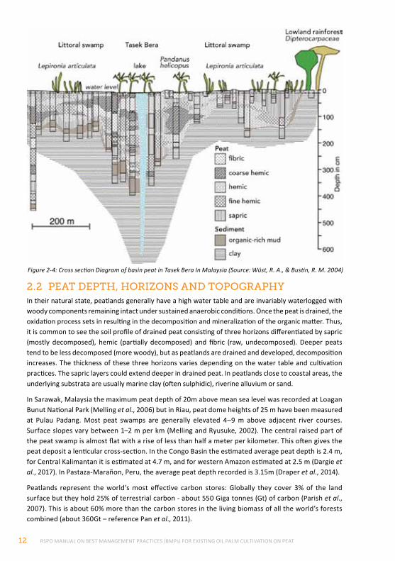
2.2 peAt depth, horIZonS And topogrAphYIn their natural state, peatlands generally have a high water table and are invariably waterlogged with woody components remaining intact under sustained anaerobic conditions. Once the peat is drained, the oxidation process sets in resulting in the decomposition and mineralization of the organic matter. Thus, it is common to see the soil profile of drained peat consisting of three horizons differentiated by sapric (mostly decomposed), hemic (partially decomposed) and fibric (raw, undecomposed). Deeper peats tend to be less decomposed (more woody), but as peatlands are drained and developed, decomposition increases. The thickness of these three horizons varies depending on the water table and cultivation practices. The sapric layers could extend deeper in drained peat. In peatlands close to coastal areas, the underlying substrata are usually marine clay (often sulphidic), riverine alluvium or sand.
In Sarawak, Malaysia the maximum peat depth of 20m above mean sea level was recorded at Loagan Bunut National Park (Melling et al., 2006) but in Riau, peat dome heights of 25 m have been measured at Pulau Padang. Most peat swamps are generally elevated 4–9 m above adjacent river courses. Surface slopes vary between 1–2 m per km (Melling and Ryusuke, 2002). The central raised part of the peat swamp is almost flat with a rise of less than half a meter per kilometer. This often gives the peat deposit a lenticular cross-section. In the Congo Basin the estimated average peat depth is 2.4 m, for Central Kalimantan it is estimated at 4.7 m, and for western Amazon estimated at 2.5 m (Dargie et al., 2017). In Pastaza-Marañon, Peru, the average peat depth recorded is 3.15m (Draper et al., 2014).
Peatlands represent the world’s most effective carbon stores: Globally they cover 3% of the land surface but they hold 25% of terrestrial carbon - about 550 Giga tonnes (Gt) of carbon (Parish et al., 2007). This is about 60% more than the carbon stores in the living biomass of all the world’s forests combined (about 360Gt – reference Pan et al., 2011).
Figure 2-4: Cross section Diagram of basin peat in Tasek Bera In Malaysia (Source: Wüst, R. A., & Bustin, R. M. 2004)
2.0 NATURE AND CHARACTERISTICS OF TROPICAL PEAT AND CONSTRAINTS AND IMPACT OF OIL PALM CULTIVATION 13
Dome-shaped peatlands may have distinct vegetation types, which vary according to peat depth and nutrient status. The vegetation also influences the nature of the peat and the constraints for cultivation. It is noted that plant species may differ in similar zonations elsewhere across the tropics. For example, Dargie et al., (2017) found Congo Basin peat consistently under two common vegetation types: hardwood swamp forest (in which Uapaca paludosa, Carapa procera and Xylopia rubescens are common) and a palm-dominated (Raphia laurentii) swamp forest. Peat was also usually found under another, much rarer palm-dominated (Raphia hookeri) swamp forest that occupies abandoned river channels (Dargie et al., 2017).
The Peruvian Amazonia harbors a considerable diversity of peatlands which represent a gradient from very nutrient-poor to nutrient-rich (Lähteenoja and Page, 2011). They include both domed ombrotrophic as well as shallower minerotrophic peatlands. The vegetation varies from open swamp to palm forests to peat swamp forests. One of the major types are dominated by a palm species—Mauritia flexuosa, which covers about 80% of total peatland area and store ~ 2.3 Pg C (Bhomia et al., 2018). Peatland pole forests(dominated by a limited number of tree species) of the Pastaza-Marañón Foreland Basin (PMFB), Peru, are the most carbon-dense ecosystems known in Amazonia once below ground carbon stores are taken into account (Kelly et al., 2016)
2.3 phYSIochemIcAl propertIeS And fertIlItY of drAIned peAt
peAt phYSIcAl propertIeSThe physical properties of peat are those related to the colour, humification level, loss on ignition, bulk density/porosity and its water holding properties. These are generally summarized by Mohd Tayeb (2005) as follows:
• dark colour generally brown to very dark brown (depending on stage of decomposition);
• high organic matter content including undecomposed to semi decomposed woody materials in the forms of stumps, logs, branches and large roots;
• high water table and often inundated under its natural state, thus an anaerobic environment;
• high moisture content and water holding capacity of 15-30 times of their dry weight (Tay, 1969). This leads to high buoyancy and high pore volume leading to low bulk density (about 0.10 g/cm3) and low soil bearing capacity;
• undergoes oxidation, shrinkage, consolidation and subsidence upon drainage; and
• low bulk density (0.10-0.15 g/ cm3) of drained peat, resulting in the high porosity (85-90%) and soft ground condition. The infiltration rate is very high, ranging from 400-500 cm/ hour (Lim, 2005A). High leaching of fertilizers is expected during rainy seasons.
chemIcAl propertIeSThe chemical composition of peat is influenced by peat type. The older and thicker the organic horizon, the more impoverished are the surface layers. If the soil is regularly flooded, it has a higher amount of mineral content and is more fertile. The chemical properties of peat are described by Mohd Tayeb (2005) as follows:
• acidic in nature (pH 3-4);
• very low nutrient contents especially K, Cu and Zn;
• very low amounts of exchangeable bases thus having low percentage base saturation;
• high N but locked in the organic matter, thus its availability for plant uptake is rather low. The high C:N ratio coupled with the low pH result in low mineralization in peat (lower decomposition rate); and
• high cation-exchange capacity (CEC) due to the presence of exchangeable H+ contributed by organic acids such as carboxylic acid, phenolic acid and other organic acids.
RSPO MANUAL ON BEST MANAGEMENT PRACTICES (BMPs) FOR EXISTING OIL PALM CULTIVATION ON PEAT14
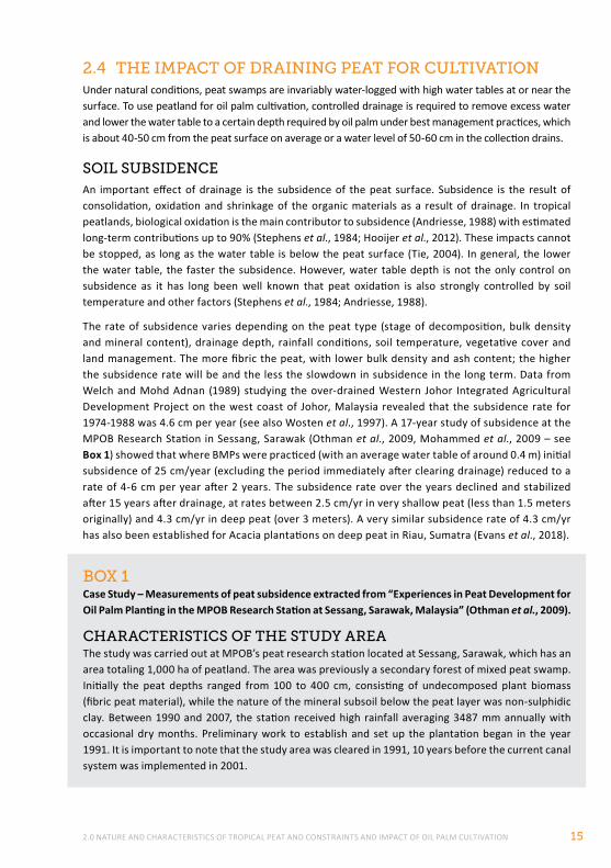
peAt fertIlItYThe fertility of drained peat is variable depending on the degree of woodiness, state of decomposition and physiochemical properties. Tropical peat is acidic (pH 3-4): the inherent Mg and Ca contents of peat are very high compared to K. The contents of essential micro-nutrients namely Cu, Zn and B are low (see Table 2-1). The total nitrogen content of drained peat is generally high for the first generation of cultivation on peat. With an organic carbon content of more than 40%, the C/N ratio is also high, affecting N mineralization in peat. The release of N in peat for palm growth is influenced by soil moisture, being more available under moist but not water-logged conditions.
In addition to having data from fertilizer response studies, it is useful and pertinent that knowledge on factors influencing the inherent fertility of peat be known when drawing up the fertilizer programme for oil palm on the peat area to be developed. Adequate and balanced application of fertilizer nutrients to oil palm ensures high oil palm productivity and cost-effectiveness. Mohd Tayeb (2005) elaborated some factors influencing peat fertility as follows:
• position of area to be developed in the landscape (proximity to mineral soil, land formations, fertility of soils in the surrounding watershed);
• position in the peat swamp (raised central parts of ombrogenous peat swamp are usually less fertile)
• nature of subsoil (mineralogy/ nutrient content, presence of mineral soil layers, presence of potential acid sulphate soils under the peat layer), and
• degree of decomposition (fibric, hemic, sapric)
CHEMICAL PROPERTIES
Lim, 2006 (Riau, Indonesia)
Melling, 2006 (Sarawak)
Joshua Mathews, 2018 (Bumitama, Kalimantan)1
Pupathy, 2018 (Sime Darby, Sarawak)1
pH 3.7 3.7 3.86 3.1
Organic C (%) 41.1 45.4 34.84 44.5
Total N (%) 1.56 1.69 1.38 1.8
C/N ratio 26.3 26.9 25.39 24.7
Exch. Ca (cmol/kg) 6.68 0.76 1.11 3.6
Exch. Mg (cmol/kg) 9.55 1.01 0.44 2.2
Exch. K (cmol/kg) 0.61 0.19 0.12 0.3
CEC (cmol/kg) 70.8 41.4 84.46 52.3
Extr P (mg/kg) 120.0 21.4 16.0 31.2
Total Cu (mg/kg) 4.1 1.4 1.14
Total Zn (mg/kg) 28.0 17.1 5.53
Total B (mg/kg) 5.0 1.1
Total Al (mg/kg) 1.35
Total Fe (mg/kg) 108.8 67.7
Table 2-1: Generalized chemical properties of surface peat (0-50 cm)
1 RSPO Peat Land Working Group workshop held at Bali on 27th November 2017 and in Miri on 25th January 2018.
The micronutrients Cu, Zn, Mn and Fe in peat occur in different concentrations depending on the nature of the peat, its drainage status and its agricultural utilization.
The electrical conductivity values (which measure the salinity of the soil) are generally less than 1 millimhos per centimeter (mmhos/cm – the basic unit of measure of electrical conductivity in soil, and the inverse of electrical transmissivity through a solution) but may go up to more than 4 mmhos/cm in some areas near to the sea. Values up to 4.7 mmhos/cm have been recorded in Tanjung Karang area near to the coast and influenced by sea water (Ismail, 1984). Water source with a salinity of more than 4 mmhos/cm is not suitable for oil palm cultivation due to reverse osmosis (Lim et al., 2004).
2.0 NATURE AND CHARACTERISTICS OF TROPICAL PEAT AND CONSTRAINTS AND IMPACT OF OIL PALM CULTIVATION 15
2.4 the ImpAct of drAInIng peAt for cultIvAtIonUnder natural conditions, peat swamps are invariably water-logged with high water tables at or near the surface. To use peatland for oil palm cultivation, controlled drainage is required to remove excess water and lower the water table to a certain depth required by oil palm under best management practices, which is about 40-50 cm from the peat surface on average or a water level of 50-60 cm in the collection drains.
SoIl SuBSIdenceAn important effect of drainage is the subsidence of the peat surface. Subsidence is the result of consolidation, oxidation and shrinkage of the organic materials as a result of drainage. In tropical peatlands, biological oxidation is the main contributor to subsidence (Andriesse, 1988) with estimated long-term contributions up to 90% (Stephens et al., 1984; Hooijer et al., 2012). These impacts cannot be stopped, as long as the water table is below the peat surface (Tie, 2004). In general, the lower the water table, the faster the subsidence. However, water table depth is not the only control on subsidence as it has long been well known that peat oxidation is also strongly controlled by soil temperature and other factors (Stephens et al., 1984; Andriesse, 1988).
The rate of subsidence varies depending on the peat type (stage of decomposition, bulk density and mineral content), drainage depth, rainfall conditions, soil temperature, vegetative cover and land management. The more fibric the peat, with lower bulk density and ash content; the higher the subsidence rate will be and the less the slowdown in subsidence in the long term. Data from Welch and Mohd Adnan (1989) studying the over-drained Western Johor Integrated Agricultural Development Project on the west coast of Johor, Malaysia revealed that the subsidence rate for 1974-1988 was 4.6 cm per year (see also Wosten et al., 1997). A 17-year study of subsidence at the MPOB Research Station in Sessang, Sarawak (Othman et al., 2009, Mohammed et al., 2009 – see Box 1) showed that where BMPs were practiced (with an average water table of around 0.4 m) initial subsidence of 25 cm/year (excluding the period immediately after clearing drainage) reduced to a rate of 4-6 cm per year after 2 years. The subsidence rate over the years declined and stabilized after 15 years after drainage, at rates between 2.5 cm/yr in very shallow peat (less than 1.5 meters originally) and 4.3 cm/yr in deep peat (over 3 meters). A very similar subsidence rate of 4.3 cm/yr has also been established for Acacia plantations on deep peat in Riau, Sumatra (Evans et al., 2018).
BoX 1Case Study – Measurements of peat subsidence extracted from “Experiences in Peat Development for Oil Palm Planting in the MPOB Research Station at Sessang, Sarawak, Malaysia” (Othman et al., 2009).
chArActerIStIcS of the StudY AreAThe study was carried out at MPOB’s peat research station located at Sessang, Sarawak, which has an area totaling 1,000 ha of peatland. The area was previously a secondary forest of mixed peat swamp. Initially the peat depths ranged from 100 to 400 cm, consisting of undecomposed plant biomass (fibric peat material), while the nature of the mineral subsoil below the peat layer was non-sulphidic clay. Between 1990 and 2007, the station received high rainfall averaging 3487 mm annually with occasional dry months. Preliminary work to establish and set up the plantation began in the year 1991. It is important to note that the study area was cleared in 1991, 10 years before the current canal system was implemented in 2001.
RSPO MANUAL ON BEST MANAGEMENT PRACTICES (BMPs) FOR EXISTING OIL PALM CULTIVATION ON PEAT16
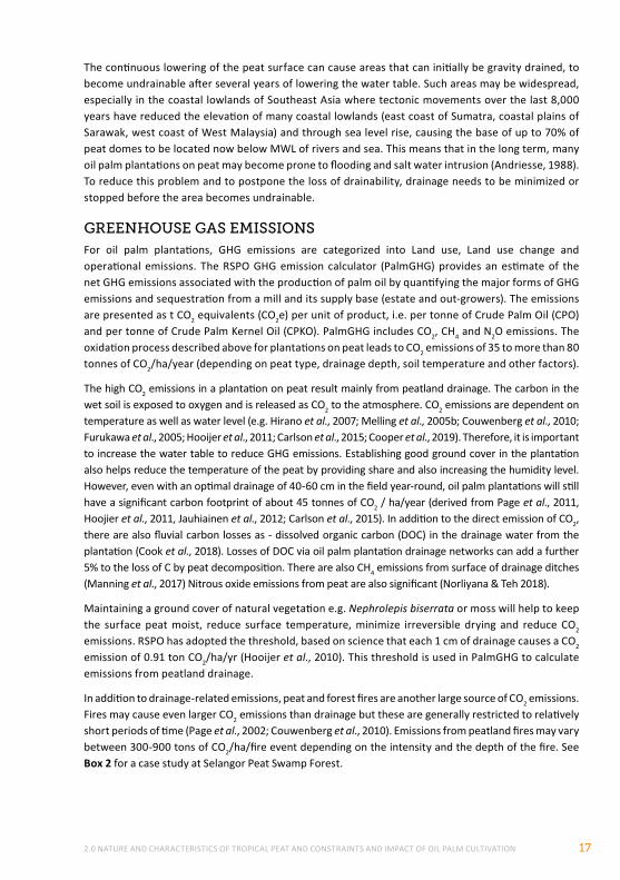
Carlson et al., (2015) estimated in their meta-analysis, based on all available research at that time, that peat soil subsidence in oil palm plantations in SE Asia is on average 4.7 cm (± 1.8 cm). They selected research from 24 sites in Riau, Johor and Sabah. Also Hooijer et al., (2012) concluded that an average subsidence rate around 5 cm/year applies to peatlands over 4 meters in depth in SE Asia after the first 5 years of drainage (during which subsidence totals around 1.4 meters); this number applies to fibric and hemic peat with low mineral content at water depths around 0.7 meters that represented the best management observed in many plantations in Indonesia at time. In such deep peatlands, hardly any soil maturation was observed after the first 5 years, with bulk densities remaining constant, and no sign of a slowing down in subsidence rate after several decades (see Figure 2-6).
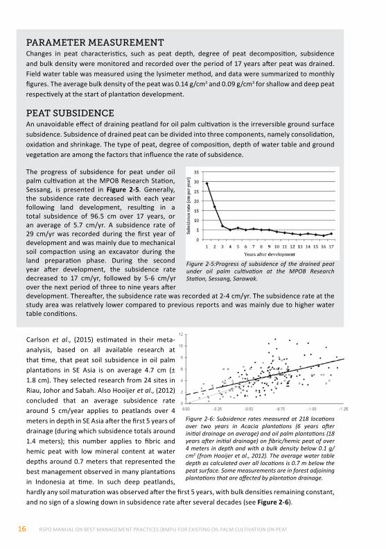
The progress of subsidence for peat under oil palm cultivation at the MPOB Research Station, Sessang, is presented in Figure 2-5. Generally, the subsidence rate decreased with each year following land development, resulting in a total subsidence of 96.5 cm over 17 years, or an average of 5.7 cm/yr. A subsidence rate of 29 cm/yr was recorded during the first year of development and was mainly due to mechanical soil compaction using an excavator during the land preparation phase. During the second year after development, the subsidence rate decreased to 17 cm/yr, followed by 5-6 cm/yr over the next period of three to nine years after development. Thereafter, the subsidence rate was recorded at 2-4 cm/yr. The subsidence rate at the study area was relatively lower compared to previous reports and was mainly due to higher water table conditions.
Figure 2-5:Progress of subsidence of the drained peat under oil palm cultivation at the MPOB Research Station, Sessang, Sarawak.
Figure 2-6: Subsidence rates measured at 218 locations over two years in Acacia plantations (6 years after initial drainage on average) and oil palm plantations (18 years after initial drainage) on fibric/hemic peat of over 4 meters in depth and with a bulk density below 0.1 g/cm3 (from Hooijer et al., 2012). The average water table depth as calculated over all locations is 0.7 m below the peat surface. Some measurements are in forest adjoining plantations that are affected by plantation drainage.
pArAmeter meASurementChanges in peat characteristics, such as peat depth, degree of peat decomposition, subsidence and bulk density were monitored and recorded over the period of 17 years after peat was drained. Field water table was measured using the lysimeter method, and data were summarized to monthly figures. The average bulk density of the peat was 0.14 g/cm3 and 0.09 g/cm3 for shallow and deep peat respectively at the start of plantation development.
peAt SuBSIdenceAn unavoidable effect of draining peatland for oil palm cultivation is the irreversible ground surface subsidence. Subsidence of drained peat can be divided into three components, namely consolidation, oxidation and shrinkage. The type of peat, degree of composition, depth of water table and ground vegetation are among the factors that influence the rate of subsidence.
2.0 NATURE AND CHARACTERISTICS OF TROPICAL PEAT AND CONSTRAINTS AND IMPACT OF OIL PALM CULTIVATION 17
The continuous lowering of the peat surface can cause areas that can initially be gravity drained, to become undrainable after several years of lowering the water table. Such areas may be widespread, especially in the coastal lowlands of Southeast Asia where tectonic movements over the last 8,000 years have reduced the elevation of many coastal lowlands (east coast of Sumatra, coastal plains of Sarawak, west coast of West Malaysia) and through sea level rise, causing the base of up to 70% of peat domes to be located now below MWL of rivers and sea. This means that in the long term, many oil palm plantations on peat may become prone to flooding and salt water intrusion (Andriesse, 1988). To reduce this problem and to postpone the loss of drainability, drainage needs to be minimized or stopped before the area becomes undrainable.
greenhouSe gAS emISSIonSFor oil palm plantations, GHG emissions are categorized into Land use, Land use change and operational emissions. The RSPO GHG emission calculator (PalmGHG) provides an estimate of the net GHG emissions associated with the production of palm oil by quantifying the major forms of GHG emissions and sequestration from a mill and its supply base (estate and out-growers). The emissions are presented as t CO2 equivalents (CO2e) per unit of product, i.e. per tonne of Crude Palm Oil (CPO) and per tonne of Crude Palm Kernel Oil (CPKO). PalmGHG includes CO2, CH4 and N2O emissions. The oxidation process described above for plantations on peat leads to CO2 emissions of 35 to more than 80 tonnes of CO2/ha/year (depending on peat type, drainage depth, soil temperature and other factors).
The high CO2 emissions in a plantation on peat result mainly from peatland drainage. The carbon in the wet soil is exposed to oxygen and is released as CO2 to the atmosphere. CO2 emissions are dependent on temperature as well as water level (e.g. Hirano et al., 2007; Melling et al., 2005b; Couwenberg et al., 2010; Furukawa et al., 2005; Hooijer et al., 2011; Carlson et al., 2015; Cooper et al., 2019). Therefore, it is important to increase the water table to reduce GHG emissions. Establishing good ground cover in the plantation also helps reduce the temperature of the peat by providing share and also increasing the humidity level. However, even with an optimal drainage of 40-60 cm in the field year-round, oil palm plantations will still have a significant carbon footprint of about 45 tonnes of CO2 / ha/year (derived from Page et al., 2011, Hoojier et al., 2011, Jauhiainen et al., 2012; Carlson et al., 2015). In addition to the direct emission of CO2, there are also fluvial carbon losses as - dissolved organic carbon (DOC) in the drainage water from the plantation (Cook et al., 2018). Losses of DOC via oil palm plantation drainage networks can add a further 5% to the loss of C by peat decomposition. There are also CH4 emissions from surface of drainage ditches (Manning et al., 2017) Nitrous oxide emissions from peat are also significant (Norliyana & Teh 2018).
Maintaining a ground cover of natural vegetation e.g. Nephrolepis biserrata or moss will help to keep the surface peat moist, reduce surface temperature, minimize irreversible drying and reduce CO2 emissions. RSPO has adopted the threshold, based on science that each 1 cm of drainage causes a CO2 emission of 0.91 ton CO2/ha/yr (Hooijer et al., 2010). This threshold is used in PalmGHG to calculate emissions from peatland drainage.
In addition to drainage-related emissions, peat and forest fires are another large source of CO2 emissions. Fires may cause even larger CO2 emissions than drainage but these are generally restricted to relatively short periods of time (Page et al., 2002; Couwenberg et al., 2010). Emissions from peatland fires may vary between 300-900 tons of CO2/ha/fire event depending on the intensity and the depth of the fire. See Box 2 for a case study at Selangor Peat Swamp Forest.
RSPO MANUAL ON BEST MANAGEMENT PRACTICES (BMPs) FOR EXISTING OIL PALM CULTIVATION ON PEAT18
BoX 2Case Study: Selangor Peat Swamp Forest, Malaysia – Subsidence, fire and GHG assessment.
Ongoing research focused in peatlands in Selangor, Malaysia by a research consortium comprising Tropical Catchment Research Initiative (TROCARI) in collaboration with The University of Nottingham, Liverpool John Moores University, Leicester University, Edgehill University, Global Environment Centre and supported by the Selangor State Forestry Department are considering a range of parameters to assess local to landscape-scale changes to landuse cover and impacts to peat function.
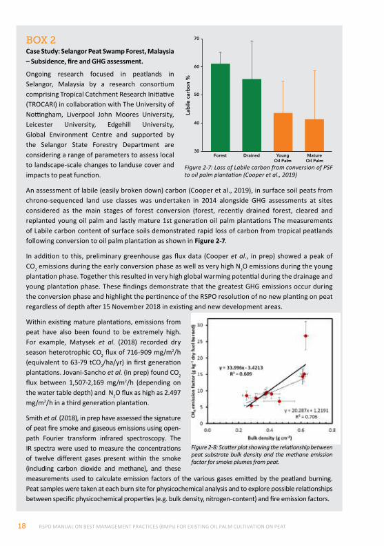
An assessment of labile (easily broken down) carbon (Cooper et al., 2019), in surface soil peats from chrono-sequenced land use classes was undertaken in 2014 alongside GHG assessments at sites considered as the main stages of forest conversion (forest, recently drained forest, cleared and replanted young oil palm and lastly mature 1st generation oil palm plantations The measurements of Labile carbon content of surface soils demonstrated rapid loss of carbon from tropical peatlands following conversion to oil palm plantation as shown in Figure 2-7.
In addition to this, preliminary greenhouse gas flux data (Cooper et al., in prep) showed a peak of CO2 emissions during the early conversion phase as well as very high N2O emissions during the young plantation phase. Together this resulted in very high global warming potential during the drainage and young plantation phase. These findings demonstrate that the greatest GHG emissions occur during the conversion phase and highlight the pertinence of the RSPO resolution of no new planting on peat regardless of depth after 15 November 2018 in existing and new development areas.
Within existing mature plantations, emissions from peat have also been found to be extremely high. For example, Matysek et al. (2018) recorded dry season heterotrophic CO2 flux of 716-909 mg/m2/h (equivalent to 63-79 tCO2/ha/yr) in first generation plantations. Jovani-Sancho et al. (in prep) found CO2 flux between 1,507-2,169 mg/m2/h (depending on the water table depth) and N2O flux as high as 2.497 mg/m2/h in a third generation plantation.
Smith et al. (2018), in prep have assessed the signature of peat fire smoke and gaseous emissions using open-path Fourier transform infrared spectroscopy. The IR spectra were used to measure the concentrations of twelve different gases present within the smoke (including carbon dioxide and methane), and these measurements used to calculate emission factors of the various gases emitted by the peatland burning. Peat samples were taken at each burn site for physicochemical analysis and to explore possible relationships between specific physicochemical properties (e.g. bulk density, nitrogen-content) and fire emission factors.
Figure 2-7: Loss of Labile carbon from conversion of PSF to oil palm plantation (Cooper et al., 2019)
30Forest Drained Young
Oil PalmMatureOil Palm
40
50
60
70
Lab
ile c
arb
on
%
Figure 2-8: Scatter plot showing the relationship between peat substrate bulk density and the methane emission factor for smoke plumes from peat.
2.0 NATURE AND CHARACTERISTICS OF TROPICAL PEAT AND CONSTRAINTS AND IMPACT OF OIL PALM CULTIVATION 19
Figure 2-9: Scatter plots showing the relationship between peat substrate peat nitrogen content and ammonia (left) and hydrogen cyanide (right) emission factors. A linear regression line of best-fit is presented (solid black line). Both lines of best-fit have a statistically significant non-zero slope (p<0.05).
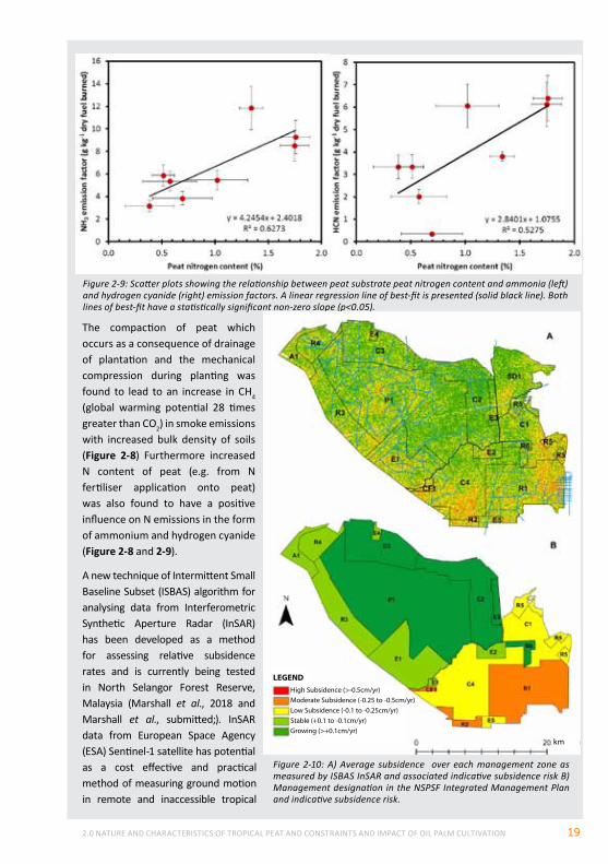
The compaction of peat which occurs as a consequence of drainage of plantation and the mechanical compression during planting was found to lead to an increase in CH4 (global warming potential 28 times greater than CO2) in smoke emissions with increased bulk density of soils (Figure 2-8) Furthermore increased N content of peat (e.g. from N fertiliser application onto peat) was also found to have a positive influence on N emissions in the form of ammonium and hydrogen cyanide (Figure 2-8 and 2-9).
A new technique of Intermittent Small Baseline Subset (ISBAS) algorithm for analysing data from Interferometric Synthetic Aperture Radar (InSAR) has been developed as a method for assessing relative subsidence rates and is currently being tested in North Selangor Forest Reserve, Malaysia (Marshall et al., 2018 and Marshall et al., submitted;). InSAR data from European Space Agency (ESA) Sentinel-1 satellite has potential as a cost effective and practical method of measuring ground motion in remote and inaccessible tropical
Figure 2-10: A) Average subsidence over each management zone as measured by ISBAS InSAR and associated indicative subsidence risk B) Management designation in the NSPSF Integrated Management Plan and indicative subsidence risk.
km
LEGENDHigh Subsidence (>-0.5cm/yr)Moderate Subsidence (-0.25 to -0.5cm/yr)Low Subsidence (-0.1 to -0.25cm/yr)Stable (+0.1 to -0.1cm/yr)Growing (>+0.1cm/yr)
RSPO MANUAL ON BEST MANAGEMENT PRACTICES (BMPs) FOR EXISTING OIL PALM CULTIVATION ON PEAT20
IncreASed fIre rISkPeatland fires are a serious problem in Southeast Asia and elsewhere – especially where peatlands have been opened up or drained. The ‘Manual for the Control of Fire in Peatland and Peatland Forest’ published by Wetlands International Indonesia Programme in December 2005 (Wetlands International – Indonesia Programme, 2005b) elaborates on a variety of concepts and practical measures for the prevention and suppression of fire. The following are important elements quoted from this Manual:
• Fires occur in peatland, particularly during the dry season when these areas dry out (especially when deforested and drained). Overcoming fire on drained and deforested peatland is extremely difficult, compared with fire in areas where there is no peat. The spread of ground fire in peatlands is difficult to detect because it can extend down to deeper levels or to more distant areas without being visible from the surface. On peatlands, if a fire is not quickly suppressed, or if it has already penetrated far into the peat layer, it will be difficult to extinguish. Moreover, the main obstacles to putting out fires are difficulties in obtaining large quantities of water nearby and gaining access to the site of the blaze. For these reasons, severe/extensive peatland fires can only be extinguished by natural means i.e. long consistent periods of heavy rain.
• Peat fires in general are now recognized as a global threat with serious economic and ecological impacts. The health of people may be affected through haze and toxic particles and greenhouse gases are released into the atmosphere seriously impacting the climate. The carbon that is lost from the peat soil will not return, unless peatlands are rewetted and rehabilitated. Another key point about peat fires is that the smoldering nature of the combustion process means that they also release methane CH4 (as well as CO2); CH4 has a much stronger global warming potential.
peatlands. The ISBAS algorithm provides a verified method for the measurement of ground motion over vegetated areas removing a barrier to InSAR as a method to monitor peat surface motion, factors directly related to peat condition and carbon emission. This work has examined the feasibility of using ISBAS and Sentinel 1 data to measure short-term (Dec 2013-June 2017) tropical peat motion in the North Selangor Forest Reserve (NSPSF), Peninsular Malaysia (Figure 2-10) and its potential as a qualitative tool for the monitoring, management and regulating of tropical peatland. Comparison of ground data collected by Global Environment Centre and InSAR data shows no significant difference at 32 out of 33 validation sites. Qualitative comparison with management designations and discussions with local stakeholders showed that the InSAR data is largely in agreement with known areas of land use impacts. While the technique is still under development and it does not yet show the extent of ground motion, the direction of movement appears to agree with ground-based measures. If applied at a regional scale, the ISBAS InSAR technique has the potential to offer a method of targeting the most appropriate areas for intervention and of monitoring the effectiveness of those interventions, increasing the efficacy of peatland rehabilitation and allocation of scarce resources. In the long-term, it may aid in assessment of drainability potential of plantations.
Overall, ongoing findings have clearly illustrated that even when managed more responsibly via guidelines such as RSPO, palm oil on peat still has considerable impacts to GHG emissions, subsidence and potentially drainage acidification and mobilisation of heavy metals. As such it must be stated that no oil palm on peat can be considered fully ‘sustainable’ (Evers et al., 2017).
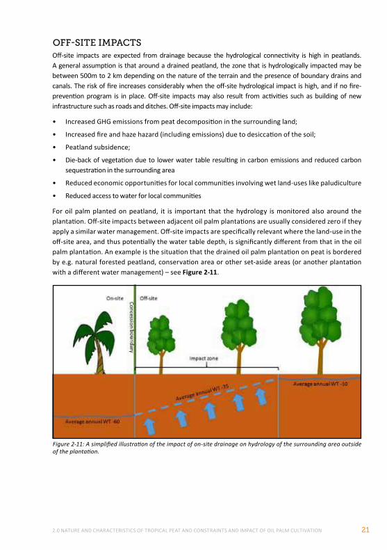
2.0 NATURE AND CHARACTERISTICS OF TROPICAL PEAT AND CONSTRAINTS AND IMPACT OF OIL PALM CULTIVATION 21
Off-site impacts are expected from drainage because the hydrological connectivity is high in peatlands. A general assumption is that around a drained peatland, the zone that is hydrologically impacted may be between 500m to 2 km depending on the nature of the terrain and the presence of boundary drains and canals. The risk of fire increases considerably when the off-site hydrological impact is high, and if no fire- prevention program is in place. Off-site impacts may also result from activities such as building of new infrastructure such as roads and ditches. Off-site impacts may include:
• Increased GHG emissions from peat decomposition in the surrounding land;
• Increased fire and haze hazard (including emissions) due to desiccation of the soil;
• Peatland subsidence;
• Die-back of vegetation due to lower water table resulting in carbon emissions and reduced carbon sequestration in the surrounding area
• Reduced economic opportunities for local communities involving wet land-uses like paludiculture
• Reduced access to water for local communities
For oil palm planted on peatland, it is important that the hydrology is monitored also around the plantation. Off-site impacts between adjacent oil palm plantations are usually considered zero if they apply a similar water management. Off-site impacts are specifically relevant where the land-use in the off-site area, and thus potentially the water table depth, is significantly different from that in the oil palm plantation. An example is the situation that the drained oil palm plantation on peat is bordered by e.g. natural forested peatland, conservation area or other set-aside areas (or another plantation with a different water management) – see Figure 2-11.
Figure 2-11: A simplified illustration of the impact of on-site drainage on hydrology of the surrounding area outside of the plantation.
off-SIte ImpActS
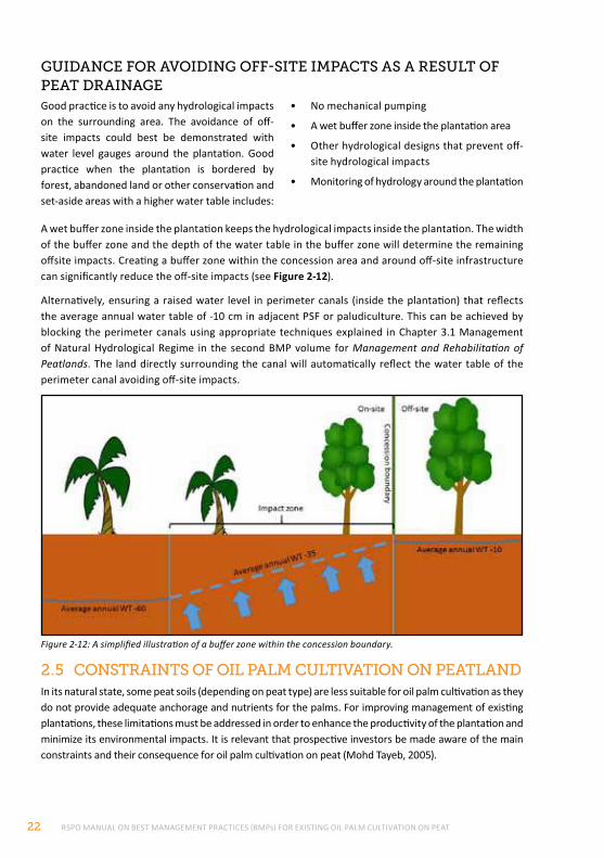
RSPO MANUAL ON BEST MANAGEMENT PRACTICES (BMPs) FOR EXISTING OIL PALM CULTIVATION ON PEAT22
2.5 conStrAIntS of oIl pAlm cultIvAtIon on peAtlAndIn its natural state, some peat soils (depending on peat type) are less suitable for oil palm cultivation as they do not provide adequate anchorage and nutrients for the palms. For improving management of existing plantations, these limitations must be addressed in order to enhance the productivity of the plantation and minimize its environmental impacts. It is relevant that prospective investors be made aware of the main constraints and their consequence for oil palm cultivation on peat (Mohd Tayeb, 2005).
Figure 2-12: A simplified illustration of a buffer zone within the concession boundary.
guIdAnce for AvoIdIng off-SIte ImpActS AS A reSult of peAt drAInAgeGood practice is to avoid any hydrological impacts on the surrounding area. The avoidance of off-site impacts could best be demonstrated with water level gauges around the plantation. Good practice when the plantation is bordered by forest, abandoned land or other conservation and set-aside areas with a higher water table includes:
• No mechanical pumping
• A wet buffer zone inside the plantation area
• Other hydrological designs that prevent off-site hydrological impacts
• Monitoring of hydrology around the plantation
A wet buffer zone inside the plantation keeps the hydrological impacts inside the plantation. The width of the buffer zone and the depth of the water table in the buffer zone will determine the remaining offsite impacts. Creating a buffer zone within the concession area and around off-site infrastructure can significantly reduce the off-site impacts (see Figure 2-12).
Alternatively, ensuring a raised water level in perimeter canals (inside the plantation) that reflects the average annual water table of -10 cm in adjacent PSF or paludiculture. This can be achieved by blocking the perimeter canals using appropriate techniques explained in Chapter 3.1 Management of Natural Hydrological Regime in the second BMP volume for Management and Rehabilitation of Peatlands. The land directly surrounding the canal will automatically reflect the water table of the perimeter canal avoiding off-site impacts.
2.0 NATURE AND CHARACTERISTICS OF TROPICAL PEAT AND CONSTRAINTS AND IMPACT OF OIL PALM CULTIVATION 23
The main constraints in the cultivation of oil palm on tropical peat can be summarized as follows:
• Presence of elevated peat dome areas that have tendency of over- drainage, flooded patches that are difficult to drain by gravity and rapidly fluctuating water table pose great challenge to effective water management, which is important for high oil palm yields on peat.
• Peat subsidence upon drainage greatly affects palm anchorage and the economic life span of peat for oil palm cultivation. Continuous subsidence can cause some areas that can initially be gravity drained to become undrainable after several years of oil palm cultivation. Intensive water management is needed to minimize the subsidence rate. Deep planting and compaction are required to reduce the palm leaning problem. .However, this practice may both increase the CH4 emissions from the soils (MK Samuel., unpublished) and result in greater CH4 emissions if the site is subject to fire (Smith et al., 2017)
• The soft ground condition of peat greatly interferes with mechanization and increases the cost of road and drainage construction/maintenance. The initial cost of development on deep peat is therefore significantly higher compared to that on mineral soils.
• Peat has a low and imbalanced nutrient content. The K is very much lower compared to Mg and Ca content. This has an antagonistic effect on the K uptake by oil palm on peat. There is also a problem with trace element fixation especially of Cu and Zn, which is significantly influenced by peat type and water availability, being more serious under an over-drained situation. The right timing of fertilizer applications to avoid rainy seasons and proper agronomic management are important for optimizing fertilizer-use efficiency on peat.
• The moist and woody nature of deep peat is very conducive for a number of important pests on oil palm especially termites, Tirathaba bunch moths and rhinoceros beetles. Weed growth is also more rapid on peat.
Chapters 3.0, 4.0 and 5.0 give guidance in the form of BMPs to overcome or mitigate some of the above constraints of cultivating oil palm on peatland.
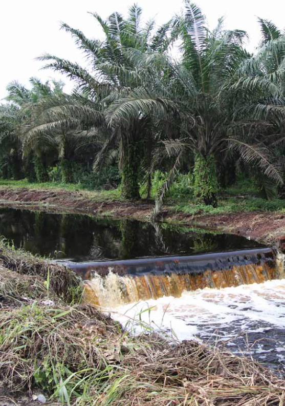
RSPO MANUAL ON BEST MANAGEMENT PRACTICES (BMPs) FOR EXISTING OIL PALM CULTIVATION ON PEAT24
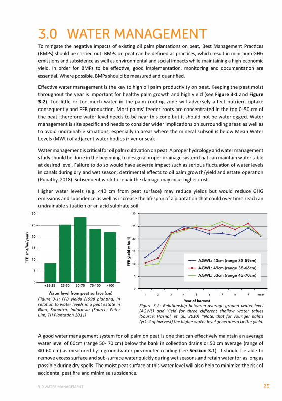
3.0 WATER MANAGEMENT 25
3.0 wATER MANAGEMENTTo mitigate the negative impacts of existing oil palm plantations on peat, Best Management Practices (BMPs) should be carried out. BMPs on peat can be defined as practices, which result in minimum GHG emissions and subsidence as well as environmental and social impacts while maintaining a high economic yield. In order for BMPs to be effective, good implementation, monitoring and documentation are essential. Where possible, BMPs should be measured and quantified.
Effective water management is the key to high oil palm productivity on peat. Keeping the peat moist throughout the year is important for healthy palm growth and high yield (see Figure 3-1 and Figure 3-2). Too little or too much water in the palm rooting zone will adversely affect nutrient uptake consequently and FFB production. Most palms’ feeder roots are concentrated in the top 0-50 cm of the peat; therefore water level needs to be near this zone but it should not be waterlogged. Water management is site specific and needs to consider wider implications on surrounding areas as well as to avoid undrainable situations, especially in areas where the mineral subsoil is below Mean Water Levels (MWL) of adjacent water bodies (river or sea).
Water management is critical for oil palm cultivation on peat. A proper hydrology and water management study should be done in the beginning to design a proper drainage system that can maintain water table at desired level. Failure to do so would have adverse impact such as serious fluctuation of water levels in canals during dry and wet season; detrimental effects to oil palm growth/yield and estate operation (Pupathy, 2018). Subsequent work to repair the damage may incur higher cost.
Higher water levels (e.g. <40 cm from peat surface) may reduce yields but would reduce GHG emissions and subsidence as well as increase the lifespan of a plantation that could over time reach an undrainable situation or an acid sulphate soil.
A good water management system for oil palm on peat is one that can effectively maintain an average water level of 60cm (range 50- 70 cm) below the bank in collection drains or 50 cm average (range of 40-60 cm) as measured by a groundwater piezometer reading (see Section 3.1). It should be able to remove excess surface and sub-surface water quickly during wet seasons and retain water for as long as possible during dry spells. The moist peat surface at this water level will also help to minimize the risk of accidental peat fire and minimise subsidence.
0
15
10
5
20
25
30
FFB
(mt/
ha/y
ear)
Water level from peat surface (cm)
+25-25 25-50 75-100 >10050-75
Figure 3-1: FFB yields (1998 planting) in relation to water levels in a peat estate in Riau, Sumatra, Indonesia (Source: Peter Lim, TH Plantation 2011)
Figure 3-2: Relationship between average ground water level (AGWL) and Yield for three different shallow water tables (Source: Hasnol, et. al., 2010) *Note: that for younger palms (yr1-4 of harvest) the higher water level generates a better yield.
1
0
5
10
15
20
25
30
2 3 4
Year of harvest
FFB
yie
ld (
t ha
-1)
5 6 7 8 9 mean
AGWL: 43cm (range 33-59cm)
AGWL: 49cm (range 38-66cm)
AGWL: 53cm (range 43-70cm)
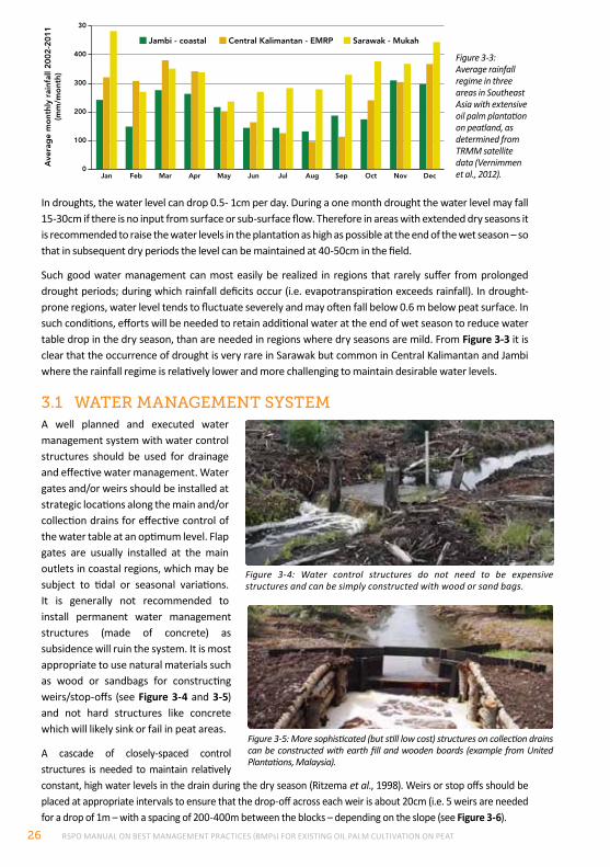
RSPO MANUAL ON BEST MANAGEMENT PRACTICES (BMPs) FOR EXISTING OIL PALM CULTIVATION ON PEAT26
In droughts, the water level can drop 0.5- 1cm per day. During a one month drought the water level may fall 15-30cm if there is no input from surface or sub-surface flow. Therefore in areas with extended dry seasons it is recommended to raise the water levels in the plantation as high as possible at the end of the wet season – so that in subsequent dry periods the level can be maintained at 40-50cm in the field.
Such good water management can most easily be realized in regions that rarely suffer from prolonged drought periods; during which rainfall deficits occur (i.e. evapotranspiration exceeds rainfall). In drought-prone regions, water level tends to fluctuate severely and may often fall below 0.6 m below peat surface. In such conditions, efforts will be needed to retain additional water at the end of wet season to reduce water table drop in the dry season, than are needed in regions where dry seasons are mild. From Figure 3-3 it is clear that the occurrence of drought is very rare in Sarawak but common in Central Kalimantan and Jambi where the rainfall regime is relatively lower and more challenging to maintain desirable water levels.
3.1 wAter mAnAgement SYStemA well planned and executed water management system with water control structures should be used for drainage and effective water management. Water gates and/or weirs should be installed at strategic locations along the main and/or collection drains for effective control of the water table at an optimum level. Flap gates are usually installed at the main outlets in coastal regions, which may be subject to tidal or seasonal variations. It is generally not recommended to install permanent water management structures (made of concrete) as subsidence will ruin the system. It is most appropriate to use natural materials such as wood or sandbags for constructing weirs/stop-offs (see Figure 3-4 and 3-5) and not hard structures like concrete which will likely sink or fail in peat areas.
A cascade of closely-spaced control structures is needed to maintain relatively constant, high water levels in the drain during the dry season (Ritzema et al., 1998). Weirs or stop offs should be placed at appropriate intervals to ensure that the drop-off across each weir is about 20cm (i.e. 5 weirs are needed for a drop of 1m – with a spacing of 200-400m between the blocks – depending on the slope (see Figure 3-6).
Figure 3-5: More sophisticated (but still low cost) structures on collection drains can be constructed with earth fill and wooden boards (example from United Plantations, Malaysia).
0
300
200
100
400
30
Ave
rag
e m
ont
hly
rain
fall
2002
-201
1(m
m/m
ont
h)
Jambi - coastal Central Kalimantan - EMRP Sarawak - Mukah
Jan Feb Mar Apr Nov DecMay Jul Aug Sep OctJun
Figure 3-3: Average rainfall regime in three areas in Southeast Asia with extensive oil palm plantation on peatland, as determined from TRMM satellite data (Vernimmen et al., 2012).
Figure 3-4: Water control structures do not need to be expensive structures and can be simply constructed with wood or sand bags.
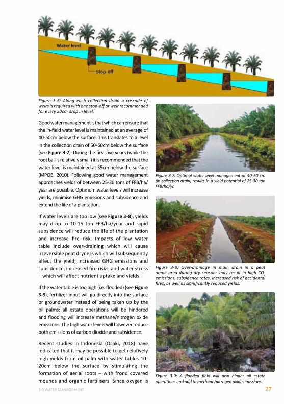
3.0 WATER MANAGEMENT 27
Figure 3-6: Along each collection drain a cascade of weirs is required with one stop-off or weir recommended for every 20cm drop in level.
Figure 3-7: Optimal water level management at 40-60 cm (in collection drain) results in a yield potential of 25-30 ton FFB/ha/yr.
Figure 3-8: Over-drainage in main drain in a peat dome area during dry seasons may result in high CO2 emissions, subsidence rates, increased risk of accidental fires, as well as significantly reduced yields.
Good water management is that which can ensure that the in-field water level is maintained at an average of 40-50cm below the surface. This translates to a level in the collection drain of 50-60cm below the surface (see Figure 3-7). During the first five years (while the root ball is relatively small) it is recommended that the water level is maintained at 35cm below the surface (MPOB, 2010). Following good water management approaches yields of between 25-30 tons of FFB/ha/year are possible. Optimum water levels will increase yields, minimise GHG emissions and subsidence and extend the life of a plantation.
If water levels are too low (see Figure 3-8), yields may drop to 10-15 ton FFB/ha/year and rapid subsidence will reduce the life of the plantation and increase fire risk. Impacts of low water table include over-draining which will cause irreversible peat dryness which will subsequently affect the yield; increased GHG emissions and subsidence; increased fire risks; and water stress – which will affect nutrient uptake and yields.
If the water table is too high (i.e. flooded) (see Figure 3-9), fertilizer input will go directly into the surface or groundwater instead of being taken up by the oil palms; all estate operations will be hindered and flooding will increase methane/nitrogen oxide emissions. The high water levels will however reduce both emissions of carbon dioxide and subsidence.
Recent studies in Indonesia (Osaki, 2018) have indicated that it may be possible to get relatively high yields from oil palm with water tables 10-20cm below the surface by stimulating the formation of aerial roots – with frond covered mounds and organic fertilisers. Since oxygen is
Figure 3-9: A flooded field will also hinder all estate operations and add to methane/nitrogen oxide emissions.
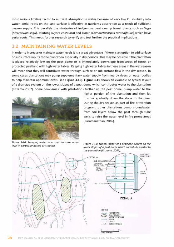
RSPO MANUAL ON BEST MANAGEMENT PRACTICES (BMPs) FOR EXISTING OIL PALM CULTIVATION ON PEAT28
most serious limiting factor to nutrient absorption in water because of very low O2 solubility into water, aerial roots on the land surface is effective in nutrients absorption as a result of sufficient oxygen supply. This parallels the strategies of indigenous peat swamp forest plants such as Sago (Metroxylon sagu), Jelutong (Dyera costulata) and Tumih (Combretocarpus rotundifolius) which have aerial roots. This needs further research to verify and test further the practical implications.
3.2 mAIntAInIng wAter levelSIn order to increase or maintain water levels it is a great advantage if there is an option to add surface or subsurface inputs to the plantation especially in dry periods. This may be possible if the plantation is placed relatively low on the peat dome or is immediately downslope from areas of forest or protected peatland with high water tables. Keeping high water tables in these areas in the wet season will mean that they will contribute water through surface or sub-surface flow in the dry season. In some cases plantations may pump supplementary water supply from nearby rivers or water bodies to help maintain optimum levels (see Figure 3-10). Figure 3-11 shows an example of typical layout of a drainage system on the lower slopes of a peat dome which contributes water to the plantation (Ritzema 2007). Some companies, with plantations further up the peat dome, pump water to the
higher portion of the plantation and then let it move gradually down the slope to the river. During the dry season as part of fire prevention program, other plantations pump groundwater from soil layers below the peat through tube wells to raise the water level in fire prone areas (Paramanathan, 2016).
Figure 3-10: Pumping water to a canal to raise water level in particular during dry season.
Figure 3-11: Typical layout of a drainage system on the lower slopes of a peat dome which contributes water to the plantation (Ritzema, 2007).
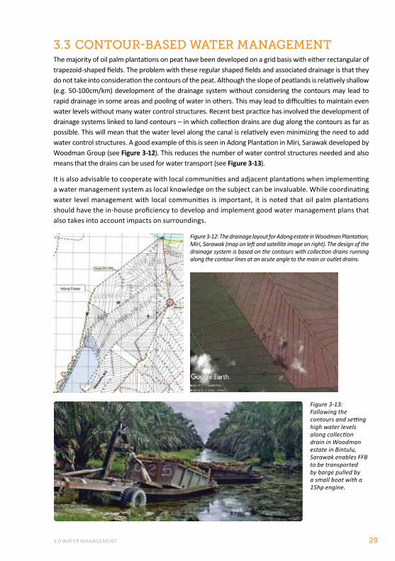
3.0 WATER MANAGEMENT 29
Figure 3-12: The drainage layout for Adong estate in Woodman Plantation, Miri, Sarawak (map on left and satellite image on right). The design of the drainage system is based on the contours with collection drains running along the contour lines at an acute angle to the main or outlet drains.
3.3 contour-BASed wAter mAnAgementThe majority of oil palm plantations on peat have been developed on a grid basis with either rectangular of trapezoid-shaped fields. The problem with these regular shaped fields and associated drainage is that they do not take into consideration the contours of the peat. Although the slope of peatlands is relatively shallow (e.g. 50-100cm/km) development of the drainage system without considering the contours may lead to rapid drainage in some areas and pooling of water in others. This may lead to difficulties to maintain even water levels without many water control structures. Recent best practice has involved the development of drainage systems linked to land contours – in which collection drains are dug along the contours as far as possible. This will mean that the water level along the canal is relatively even minimizing the need to add water control structures. A good example of this is seen in Adong Plantation in Miri, Sarawak developed by Woodman Group (see Figure 3-12). This reduces the number of water control structures needed and also means that the drains can be used for water transport (see Figure 3-13).
It is also advisable to cooperate with local communities and adjacent plantations when implementing a water management system as local knowledge on the subject can be invaluable. While coordinating water level management with local communities is important, it is noted that oil palm plantations should have the in-house proficiency to develop and implement good water management plans that also takes into account impacts on surroundings.
Figure 3-13: Following the contours and setting high water levels along collection drain in Woodman estate in Bintulu, Sarawak enables FFB to be transported by barge pulled by a small boat with a 15hp engine.
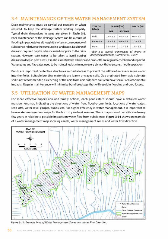
RSPO MANUAL ON BEST MANAGEMENT PRACTICES (BMPs) FOR EXISTING OIL PALM CULTIVATION ON PEAT30
Figure 3-14: Example Map of Water Management Zones and Water Flow Direction.
3.4 mAIntenAnce of the wAter mAnAgement SYStemDrain maintenance must be carried out regularly or when required, to keep the drainage system working properly. Typical drain dimensions in peat are given in Table 3-1. Poor maintenance of the drainage system can be a cause of flooding in peat estates although it is often a consequence of subsidence relative to the surrounding landscape. Desilting of drains to required depths is best carried out prior to the rainy season. However, care needs to be taken to avoid cutting drains too deep in peat areas. It is also essential that all weirs and drop-offs are regularly checked and repaired. Water gates and flap gates need to be maintained at minimum every six months to ensure smooth operation.
Bunds are important protective structures in coastal areas to prevent the inflow of excess or saline water into the fields. Suitable bunding materials are loamy or clayey soils. Clay originated from acid sulphate soil is not recommended as leaching of the acid from acid sulphate soils can have serious environmental impacts. Regular maintenance will minimize bund breakage that will result in flooding and crop losses.
3.5 utIlISAtIon of wAter mAnAgement mApSFor more effective supervision and timely actions, each peat estate should have a detailed water management map indicating the directions of water flow, flood-prone fields, locations of water-gates, stop-offs, water-level gauges, bunds, etc. For higher efficiency in water management, it is important to have water management maps for the both dry and wet seasons. These maps should be calibrated every few years in relation to possible impacts on water flow from subsidence. Figure 3-14 shows an example of a water management map showing canals, water management zones and water flow direction.
TyPE OF DRAIN
WIDTH (CM) DEPTH (M)
TOP BOTTOM
Field 1.0 – 1.2 0.5 – 0.6 0.9 – 1.0
Collection 1.8 – 2.5 0.6 – 0.9 1.2 – 1.8
Main 3.0 – 6.0 1.2 – 1.8 1.8 – 2.5
Table 3-1: Typical Dimensions of drains in peatland plantations (Gurmit et al., 1997)
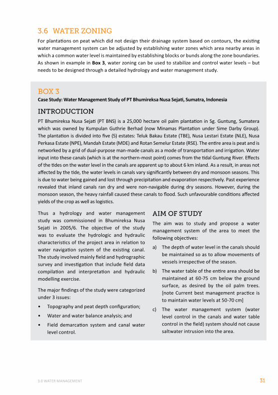
3.0 WATER MANAGEMENT 31
BoX 3Case Study: Water Management Study of PT Bhumireksa Nusa Sejati, Sumatra, Indonesia
IntroductIonPT Bhumireksa Nusa Sejati (PT BNS) is a 25,000 hectare oil palm plantation in Sg. Guntung, Sumatera which was owned by Kumpulan Guthrie Berhad (now Minamas Plantation under Sime Darby Group). The plantation is divided into five (5) estates: Teluk Bakau Estate (TBE), Nusa Lestari Estate (NLE), Nusa Perkasa Estate (NPE), Mandah Estate (MDE) and Rotan Semelur Estate (RSE). The entire area is peat and is networked by a grid of dual-purpose man-made canals as a mode of transportation and irrigation. Water input into these canals (which is at the northern-most point) comes from the tidal Guntung River. Effects of the tides on the water level in the canals are apparent up to about 6 km inland. As a result, in areas not affected by the tide, the water levels in canals vary significantly between dry and monsoon seasons. This is due to water being gained and lost through precipitation and evaporation respectively. Past experience revealed that inland canals ran dry and were non-navigable during dry seasons. However, during the monsoon season, the heavy rainfall caused these canals to flood. Such unfavourable conditions affected yields of the crop as well as logistics.
Thus a hydrology and water management study was commissioned in Bhumireksa Nusa Sejati in 2005/6. The objective of the study was to evaluate the hydrologic and hydraulic characteristics of the project area in relation to water navigation system of the existing canal. The study involved mainly field and hydrographic survey and investigation that include field data compilation and interpretation and hydraulic modelling exercise.
The major findings of the study were categorized under 3 issues:
• Topography and peat depth configuration;
• Water and water balance analysis; and
• Field demarcation system and canal water level control.
AIm of StudYThe aim was to study and propose a water management system of the area to meet the following objectives:
a) The depth of water level in the canals should be maintained so as to allow movements of vessels irrespective of the season.
b) The water table of the entire area should be maintained at 60-75 cm below the ground surface, as desired by the oil palm trees. [note Current best management practice is to maintain water levels at 50-70 cm]
c) The water management system (water level control in the canals and water table control in the field) system should not cause saltwater intrusion into the area.
3.6 wAter ZonIngFor plantations on peat which did not design their drainage system based on contours, the existing water management system can be adjusted by establishing water zones which area nearby areas in which a common water level is maintained by establishing blocks or bunds along the zone boundaries. As shown in example in Box 3, water zoning can be used to stabilize and control water levels – but needs to be designed through a detailed hydrology and water management study.
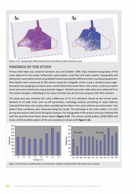
RSPO MANUAL ON BEST MANAGEMENT PRACTICES (BMPs) FOR EXISTING OIL PALM CULTIVATION ON PEAT32
Figure 3-16: Annual rainfall pattern (L) and mean rainfall monthly pattern (R) of the area studied.
fIndIngS of the StudYPrimary field data was collected between July and October 2006. Data included topography of the areas adjacent to the canals, bathymetry, peat depths, canal flow and water quality. Topography and bathymetry were determined using Global Positioning Satellite (GPS) and echo-sounding equipments. Peat depths were measured at fifty points along the navigable canals using a standard peat auger. Standard river gauging procedures were used to determine water flow in the canals. Continuous water levels were also monitored using automatic loggers. Rainfall and water table data were obtained from the estate managers. Modelling of the observed data was performed using the HEC-RAS software.
The study area was relatively flat, with a difference of 2.5 m in elevation. Based on the normal water demand of oil palm trees and run-off parameters, hydrology analysis pertaining to water balance indicated that there was surplus when considering free flow in the canal without any obstruction. Two distinct flow conditions were observed along the canals. The discharge at the main outlet is 15 m3/s during wet seasons and 3 m3/s during dry seasons. The topography of the project area was relatively flat with the potential drain flows shown above (Figure 3-15). The annual rainfall pattern (1998-2005) and mean rainfall monthly pattern of the area studied are shown with Figure 3-16.
Figure 3-15: Topography (left) and potential drain flows (right) of project area.
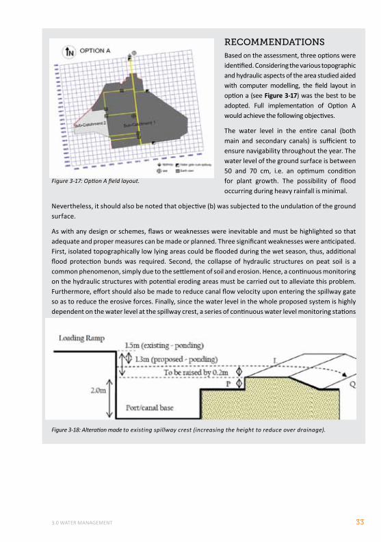
3.0 WATER MANAGEMENT 33
Figure 3-17: Option A field layout.
recommendAtIonSBased on the assessment, three options were identified. Considering the various topographic and hydraulic aspects of the area studied aided with computer modelling, the field layout in option a (see Figure 3-17) was the best to be adopted. Full implementation of Option A would achieve the following objectives.
The water level in the entire canal (both main and secondary canals) is sufficient to ensure navigability throughout the year. The water level of the ground surface is between 50 and 70 cm, i.e. an optimum condition for plant growth. The possibility of flood occurring during heavy rainfall is minimal.
Nevertheless, it should also be noted that objective (b) was subjected to the undulation of the ground surface.
As with any design or schemes, flaws or weaknesses were inevitable and must be highlighted so that adequate and proper measures can be made or planned. Three significant weaknesses were anticipated. First, isolated topographically low lying areas could be flooded during the wet season, thus, additional flood protection bunds was required. Second, the collapse of hydraulic structures on peat soil is a common phenomenon, simply due to the settlement of soil and erosion. Hence, a continuous monitoring on the hydraulic structures with potential eroding areas must be carried out to alleviate this problem. Furthermore, effort should also be made to reduce canal flow velocity upon entering the spillway gate so as to reduce the erosive forces. Finally, since the water level in the whole proposed system is highly dependent on the water level at the spillway crest, a series of continuous water level monitoring stations (preferably equipped with data loggers) was established to record continuous water levels.
Figure 3-18: Alteration made to existing spillway crest (increasing the height to reduce over drainage).
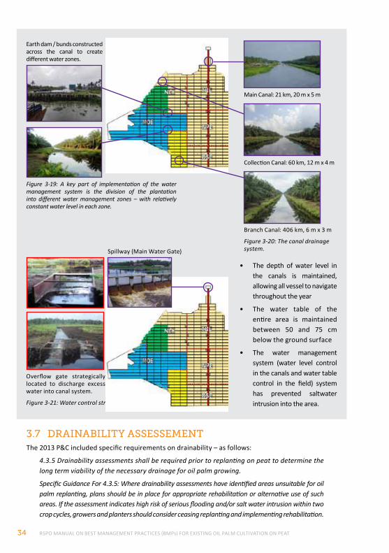
RSPO MANUAL ON BEST MANAGEMENT PRACTICES (BMPs) FOR EXISTING OIL PALM CULTIVATION ON PEAT34
• The depth of water level in the canals is maintained, allowing all vessel to navigate throughout the year
• The water table of the entire area is maintained between 50 and 75 cm below the ground surface
• The water management system (water level control in the canals and water table control in the field) system has prevented saltwater intrusion into the area.Figure 3-21: Water control structures.
Spillway (Main Water Gate)
Overflow gate strategically located to discharge excess water into canal system.
Figure 3-20: The canal drainage system.
Figure 3-19: A key part of implementation of the water management system is the division of the plantation into different water management zones – with relatively constant water level in each zone.
Earth dam / bunds constructed across the canal to create different water zones.
Main Canal: 21 km, 20 m x 5 m
Collection Canal: 60 km, 12 m x 4 m
Branch Canal: 406 km, 6 m x 3 m
3.7 drAInABIlItY ASSeSSementThe 2013 P&C included specific requirements on drainability – as follows:
4.3.5 Drainability assessments shall be required prior to replanting on peat to determine the long term viability of the necessary drainage for oil palm growing.
Specific Guidance For 4.3.5: Where drainability assessments have identified areas unsuitable for oil palm replanting, plans should be in place for appropriate rehabilitation or alternative use of such areas. If the assessment indicates high risk of serious flooding and/or salt water intrusion within two crop cycles, growers and planters should consider ceasing replanting and implementing rehabilitation.
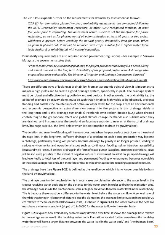
3.0 WATER MANAGEMENT 35
The 2018 P&C expands further on the requirements for drainability assessment as follows:
7.7.5 (C) For plantations planted on peat, drainability assessments are conducted following the RSPO Drainability Assessment Procedure, or other RSPO recognised methods, at least five years prior to replanting. The assessment result is used to set the timeframe for future replanting, as well as for phasing out of oil palm cultivation at least 40 years, or two cycles, whichever is greater, before reaching the natural gravity drainability limit for peat. When oil palm is phased out, it should be replaced with crops suitable for a higher water table (paludiculture) or rehabilitated with natural vegetation.
Drainability requirements are also required under government regulations – for example in Sarawak Malaysia the government states that:
"Prior to commercial development of peat soils, the project proponent shall carry out a depth survey and submit a report on the long term drainability of the proposed project area. A drainage plan proposed has to be endorsed by The Director of Irrigation and Drainage Department, Sarawak"
http://www.did.sarawak.gov.my/modules/web/pages.php?mod=webpage&sub=page&id=381
There are different ways of looking at drainability. From an agronomic point of view, it is important to maintain high yields and to create a good drainage system, specifically in peat. The drainage system must be robust and effective during both dry and wet periods. In other words: the drainability i.e. the ability of drainage by gravity alone, must be such that it enables high yields to be obtained, prevents flooding and enables the maintenance of optimum water levels for the crop. From an environmental and economic perspective an extra dimension comes into the picture: is this drainage viable in the long-term and is this drainage sustainable? Peatlands emit carbon dioxide (CO2) when drained contributing to the greenhouse effect and global climate change. Peatlands also subside when they are drained, and in some cases the peatland surface may subside to near or at the natural drainage limit/drainage base (i.e. the level below which it is not possible to drain by gravity alone).
The duration and severity of flooding will increase over time when the peat surface gets closer to the natural drainage limit. In the long term, sufficient drainage of a peatland to enable crop production may become a challenge, particularly during wet periods, because drainage by gravity is no longer possible, leading to serious environmental and operational issues such as continuous flooding, saline intrusion, accessibility issues and yield losses. If assisted drainage in the form of water pumps is applied, increased operational costs will be incurred, possibly to the extent of negative return of investment. In addition, pumped drainage will lead eventually to total loss of the peat layer and permanent flooding when pumping becomes non-viable or the concession period ends. It is therefore critical to stop drainage before reaching a point of no return.
The drainage base (see Figure 3-22) is defined as the level below which it is no longer possible to drain the land by gravity alone.
The drainage base inside the plantation is in most cases calculated in reference to the water level in the closest receiving water body and on the distance to this water body. In order to drain the plantation area, the drainage base inside the plantation must be at higher elevation than the water level in the water body. This is because there must be a difference in the water level before the water can flow. A general rule of thumb is that for each kilometer of distance into the plantation, the drainage limit elevation increases by 20 cm relative to mean sea level (DID Sarawak, 2001). As shown in Figure 3-23, the water profile in the peat soil must have a minimum gradient (slope) of 1 in 5,000 for the water to flow to the water body.
Figure 3-23 explains how drainability problems may develop over time. It shows the drainage base relative to the average water level in the receiving water body. Plantations located further away from the receiving water body will have a larger distance between ‘the water level in the water body’ and ‘the drainage base’.
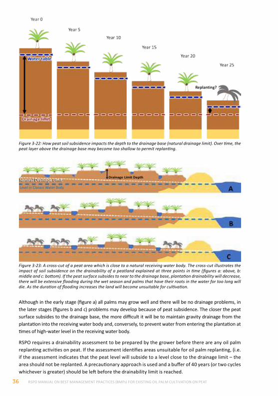
RSPO MANUAL ON BEST MANAGEMENT PRACTICES (BMPs) FOR EXISTING OIL PALM CULTIVATION ON PEAT36
Although in the early stage (figure a) all palms may grow well and there will be no drainage problems, in the later stages (figures b and c) problems may develop because of peat subsidence. The closer the peat surface subsides to the drainage base, the more difficult it will be to maintain gravity drainage from the plantation into the receiving water body and, conversely, to prevent water from entering the plantation at times of high-water level in the receiving water body.
RSPO requires a drainability assessment to be prepared by the grower before there are any oil palm replanting activities on peat. If the assessment identifies areas unsuitable for oil palm replanting, (i.e. if the assessment indicates that the peat level will subside to a level close to the drainage limit – the area should not be replanted. A precautionary approach is used and a buffer of 40 years (or two cycles whichever is greater) should be left before the drainability limit is reached.
Figure 3-22: How peat soil subsidence impacts the depth to the drainage base (natural drainage limit). Over time, the peat layer above the drainage base may become too shallow to permit replanting.
Figure 3-23: A cross-cut of a peat area which is close to a natural receiving water body. The cross-cut illustrates the impact of soil subsidence on the drainability of a peatland explained at three points in time (figures a: above, b: middle and c: bottom). If the peat surface subsides to near to the drainage base, plantation drainability will decrease, there will be extensive flooding during the wet season and palms that have their roots in the water for too long will die. As the duration of flooding increases the land will become unsuitable for cultivation.
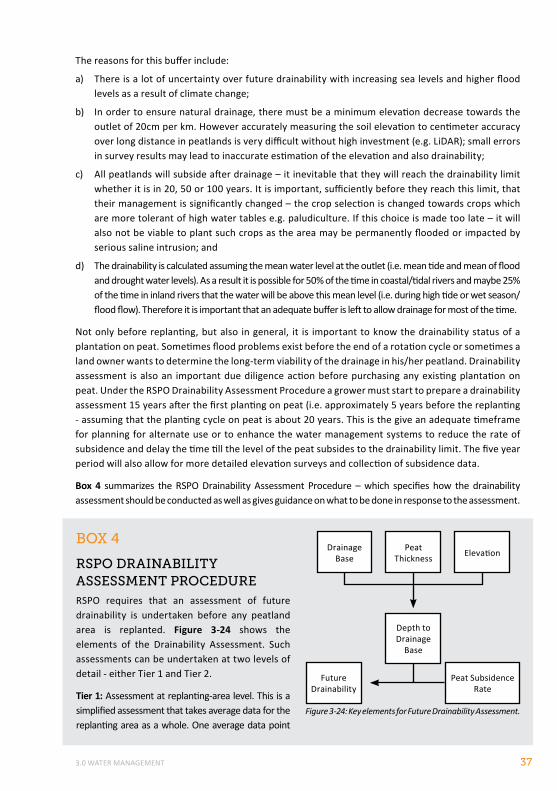
3.0 WATER MANAGEMENT 37
BoX 4
rSpo drAInABIlItY ASSeSSment procedureRSPO requires that an assessment of future drainability is undertaken before any peatland area is replanted. Figure 3-24 shows the elements of the Drainability Assessment. Such assessments can be undertaken at two levels of detail - either Tier 1 and Tier 2.
Tier 1: Assessment at replanting-area level. This is a simplified assessment that takes average data for the replanting area as a whole. One average data point
The reasons for this buffer include:
a) There is a lot of uncertainty over future drainability with increasing sea levels and higher flood levels as a result of climate change;
b) In order to ensure natural drainage, there must be a minimum elevation decrease towards the outlet of 20cm per km. However accurately measuring the soil elevation to centimeter accuracy over long distance in peatlands is very difficult without high investment (e.g. LiDAR); small errors in survey results may lead to inaccurate estimation of the elevation and also drainability;
c) All peatlands will subside after drainage – it inevitable that they will reach the drainability limit whether it is in 20, 50 or 100 years. It is important, sufficiently before they reach this limit, that their management is significantly changed – the crop selection is changed towards crops which are more tolerant of high water tables e.g. paludiculture. If this choice is made too late – it will also not be viable to plant such crops as the area may be permanently flooded or impacted by serious saline intrusion; and
d) The drainability is calculated assuming the mean water level at the outlet (i.e. mean tide and mean of flood and drought water levels). As a result it is possible for 50% of the time in coastal/tidal rivers and maybe 25% of the time in inland rivers that the water will be above this mean level (i.e. during high tide or wet season/flood flow). Therefore it is important that an adequate buffer is left to allow drainage for most of the time.
Not only before replanting, but also in general, it is important to know the drainability status of a plantation on peat. Sometimes flood problems exist before the end of a rotation cycle or sometimes a land owner wants to determine the long-term viability of the drainage in his/her peatland. Drainability assessment is also an important due diligence action before purchasing any existing plantation on peat. Under the RSPO Drainability Assessment Procedure a grower must start to prepare a drainability assessment 15 years after the first planting on peat (i.e. approximately 5 years before the replanting - assuming that the planting cycle on peat is about 20 years. This is the give an adequate timeframe for planning for alternate use or to enhance the water management systems to reduce the rate of subsidence and delay the time till the level of the peat subsides to the drainability limit. The five year period will also allow for more detailed elevation surveys and collection of subsidence data.
Box 4 summarizes the RSPO Drainability Assessment Procedure – which specifies how the drainability assessment should be conducted as well as gives guidance on what to be done in response to the assessment.
Figure 3-24: Key elements for Future Drainability Assessment.
Future Drainability
Peat Subsidence Rate
Peat Thickness
Depth to Drainage
Base
Drainage Base Elevation
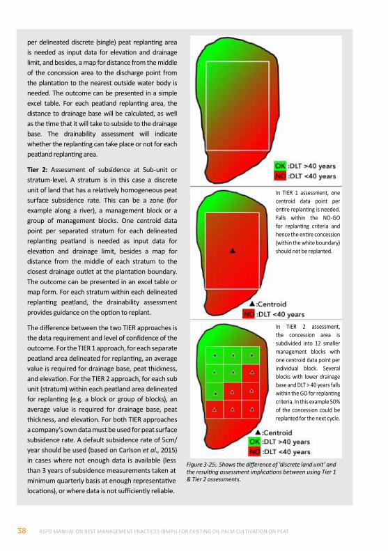
RSPO MANUAL ON BEST MANAGEMENT PRACTICES (BMPs) FOR EXISTING OIL PALM CULTIVATION ON PEAT38
per delineated discrete (single) peat replanting area is needed as input data for elevation and drainage limit, and besides, a map for distance from the middle of the concession area to the discharge point from the plantation to the nearest outside water body is needed. The outcome can be presented in a simple excel table. For each peatland replanting area, the distance to drainage base will be calculated, as well as the time that it will take to subside to the drainage base. The drainability assessment will indicate whether the replanting can take place or not for each peatland replanting area.
Tier 2: Assessment of subsidence at Sub-unit or stratum-level. A stratum is in this case a discrete unit of land that has a relatively homogeneous peat surface subsidence rate. This can be a zone (for example along a river), a management block or a group of management blocks. One centroid data point per separated stratum for each delineated replanting peatland is needed as input data for elevation and drainage limit, besides a map for distance from the middle of each stratum to the closest drainage outlet at the plantation boundary. The outcome can be presented in an excel table or map form. For each stratum within each delineated replanting peatland, the drainability assessment provides guidance on the option to replant.
The difference between the two TIER approaches is the data requirement and level of confidence of the outcome. For the TIER 1 approach, for each separate peatland area delineated for replanting, an average value is required for drainage base, peat thickness, and elevation. For the TIER 2 approach, for each sub unit (stratum) within each peatland area delineated for replanting (e.g. a block or group of blocks), an average value is required for drainage base, peat thickness, and elevation. For both TIER approaches a company’s own data must be used for peat surface subsidence rate. A default subsidence rate of 5cm/year should be used (based on Carlson et al., 2015) in cases where not enough data is available (less than 3 years of subsidence measurements taken at minimum quarterly basis at enough representative locations), or where data is not sufficiently reliable.
Figure 3-25:. Shows the difference of ‘discrete land unit’ and the resulting assessment implications between using Tier 1 & Tier 2 assessments.
In TIER 1 assessment, one centroid data point per entire replanting is needed. Falls within the NO-GO for replanting criteria and hence the entire concession (within the white boundary) should not be replanted.
In TIER 2 assessment, the concession area is subdivided into 12 smaller management blocks with one centroid data point per individual block. Several blocks with lower drainage base and DLT > 40 years falls within the GO for replanting criteria. In this example 50% of the concession could be replanted for the next cycle.
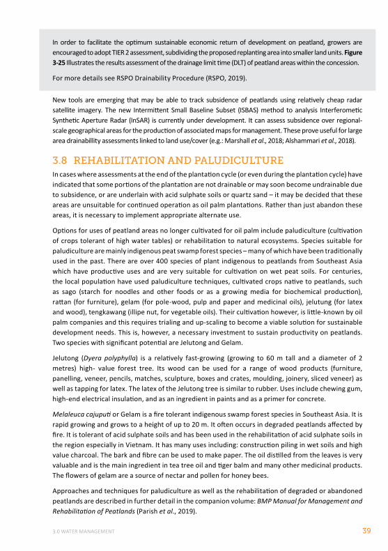
3.0 WATER MANAGEMENT 39
New tools are emerging that may be able to track subsidence of peatlands using relatively cheap radar satellite imagery. The new Intermittent Small Baseline Subset (ISBAS) method to analysis Interferometic Synthetic Aperture Radar (InSAR) is currently under development. It can assess subsidence over regional-scale geographical areas for the production of associated maps for management. These prove useful for large area drainabillity assessments linked to land use/cover (e.g.: Marshall et al., 2018; Alshammari et al., 2018).
3.8 rehABIlItAtIon And pAludIcultureIn cases where assessments at the end of the plantation cycle (or even during the plantation cycle) have indicated that some portions of the plantation are not drainable or may soon become undrainable due to subsidence, or are underlain with acid sulphate soils or quartz sand – it may be decided that these areas are unsuitable for continued operation as oil palm plantations. Rather than just abandon these areas, it is necessary to implement appropriate alternate use.
Options for uses of peatland areas no longer cultivated for oil palm include paludiculture (cultivation of crops tolerant of high water tables) or rehabilitation to natural ecosystems. Species suitable for paludiculture are mainly indigenous peat swamp forest species – many of which have been traditionally used in the past. There are over 400 species of plant indigenous to peatlands from Southeast Asia which have productive uses and are very suitable for cultivation on wet peat soils. For centuries, the local population have used paludiculture techniques, cultivated crops native to peatlands, such as sago (starch for noodles and other foods or as a growing media for biochemical production), rattan (for furniture), gelam (for pole-wood, pulp and paper and medicinal oils), jelutung (for latex and wood), tengkawang (illipe nut, for vegetable oils). Their cultivation however, is little-known by oil palm companies and this requires trialing and up-scaling to become a viable solution for sustainable development needs. This is, however, a necessary investment to sustain productivity on peatlands. Two species with significant potential are Jelutong and Gelam.
Jelutong (Dyera polyphylla) is a relatively fast-growing (growing to 60 m tall and a diameter of 2 metres) high- value forest tree. Its wood can be used for a range of wood products (furniture, panelling, veneer, pencils, matches, sculpture, boxes and crates, moulding, joinery, sliced veneer) as well as tapping for latex. The latex of the Jelutong tree is similar to rubber. Uses include chewing gum, high-end electrical insulation, and as an ingredient in paints and as a primer for concrete.
Melaleuca cajuputi or Gelam is a fire tolerant indigenous swamp forest species in Southeast Asia. It is rapid growing and grows to a height of up to 20 m. It often occurs in degraded peatlands affected by fire. It is tolerant of acid sulphate soils and has been used in the rehabilitation of acid sulphate soils in the region especially in Vietnam. It has many uses including: construction piling in wet soils and high value charcoal. The bark and fibre can be used to make paper. The oil distilled from the leaves is very valuable and is the main ingredient in tea tree oil and tiger balm and many other medicinal products. The flowers of gelam are a source of nectar and pollen for honey bees.
Approaches and techniques for paludiculture as well as the rehabilitation of degraded or abandoned peatlands are described in further detail in the companion volume: BMP Manual for Management and Rehabilitation of Peatlands (Parish et al., 2019).
In order to facilitate the optimum sustainable economic return of development on peatland, growers are encouraged to adopt TIER 2 assessment, subdividing the proposed replanting area into smaller land units. Figure 3-25 Illustrates the results assessment of the drainage limit time (DLT) of peatland areas within the concession.
For more details see RSPO Drainability Procedure (RSPO, 2019).
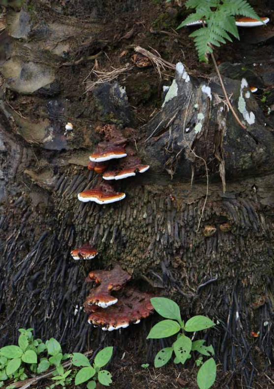
RSPO MANUAL ON BEST MANAGEMENT PRACTICES (BMPs) FOR EXISTING OIL PALM CULTIVATION ON PEAT40
4.0 MANAGEMENT OF NUTRIENTS, PESTS AND DISEASES 41
4.0 MANAGEMENT OF NUTRIENTS, PESTS ANd dISEASES
4.1 fertIlIZer And nutrIent mAnAgementAlthough the palm products, crude palm oil (CPO) and palm kernel mainly comprise of Carbon (C), Hydrogen (H) and Oxygen (O2), the requirement of nutrients in oil palm is generally high in order to sustain long term high yields. The nutrients are immobilized in the growing trunk of oil palm and removed through fresh fruit bunch (FFB). Unlike mineral soils, depending on the type of peat, retaining the applied nutrients in peat is difficult especially the highly required potassium nutrient due to low bulk density, high infiltration rate and porosity. Water level in peat is maintained at 40 to 50cm from ground level. There is a possibility to attain higher water level than the usual level of 40 to 50cm in the event of high rainfall in monsoon months. Under such situation, the chances of nutrient loss from the applied fertilizer through surface run off and leaching are high. Retention of nutrients, especially potassium from recycled fronds may also be difficult in peat due to the high water levels. Peat in general mineralizes carbon and nitrogen. It contains high carbon, nitrogen, available and total phosphorous, magnesium and low potassium. Imbalance of potassium and nitrogen is common in peat oil palm planting resulting in white stripe symptom. Micro-nutrients requirement is another important aspect for palms planted in peat. Boron, Copper and Zinc are considered routine micro-nutrients required for the palms. Lately in replanting, iron deficiency has been reported to be a part of the micro-nutrient requirement. High yields are reported in peat with appropriate balanced fertilization and agro-management practices. The current chapter in this RSPO Manual is intended to provide the best management practices that can be applied and implemented in a practical manner in the field without much adverse negative impact over the surrounding environment. Companies may adapt this guidance depending on the actual situation in their plantation but should use equivalent or more advanced approaches.
The fertilizer requirement in palms planted on peat is not the same as that of mineral soils. A good soil map of the estate is required to identify fields that are planted with oil palm on peat. Such soil surveyed map should be made available for the fertilizer recommendation (Figure 4-1). An experienced agronomist should be engaged to draw annual fertilizer recommendations depending on the data on climate, field observation, palm age, palm growth, potential FFB production and information of peat and palm leaf nutrient statuses. The type of fertilizers to be used can be straights, mixture and compound (formulated specially for peat). Agronomists should draw annual fertilizer recommendations based on the month of application, rates or dosage of individual fertilizer and total tonnage of fertilizer required for the year. Lately, drones are used to observe field and canopy of palm nutrition condition.
A good agronomist should be engaged to identify and classify the peat planting of oil palm in the estate. The surveyed map should provide peatland planting based on the definition given in the RSPO Manual. The map should be provided with the information of oil palm planted field identification numbers and area of land planted on peat, which will aid the agronomist to provide total and type of fertilizers required specifically for peatland plantings. With a good surveyed map, agronomist can provide recommendations within the scope of peat, thus recommending the right quantity and type of fertilizers for peat planting. At the time of survey, peat profile sample should be collected and analyzed for basic information of inherent characters such as loss of ignition, pH, carbon, nitrogen, available and total phosphorous, cationic exchange capacity, exchangeable calcium, potassium and calcium.
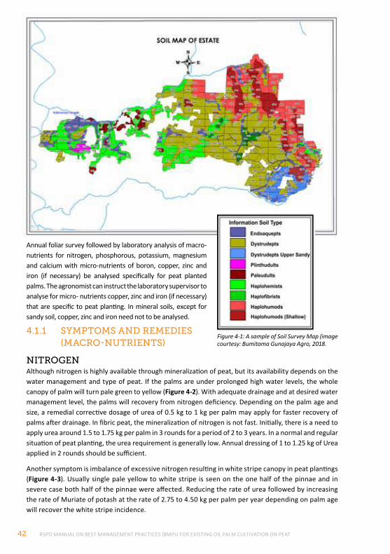
RSPO MANUAL ON BEST MANAGEMENT PRACTICES (BMPs) FOR EXISTING OIL PALM CULTIVATION ON PEAT42
Annual foliar survey followed by laboratory analysis of macro-nutrients for nitrogen, phosphorous, potassium, magnesium and calcium with micro-nutrients of boron, copper, zinc and iron (if necessary) be analysed specifically for peat planted palms. The agronomist can instruct the laboratory supervisor to analyse for micro- nutrients copper, zinc and iron (if necessary) that are specific to peat planting. In mineral soils, except for sandy soil, copper, zinc and iron need not to be analysed.
4.1.1 SYmptomS And remedIeS (mAcro-nutrIentS)
nItrogenAlthough nitrogen is highly available through mineralization of peat, but its availability depends on the water management and type of peat. If the palms are under prolonged high water levels, the whole canopy of palm will turn pale green to yellow (Figure 4-2). With adequate drainage and at desired water management level, the palms will recovery from nitrogen deficiency. Depending on the palm age and size, a remedial corrective dosage of urea of 0.5 kg to 1 kg per palm may apply for faster recovery of palms after drainage. In fibric peat, the mineralization of nitrogen is not fast. Initially, there is a need to apply urea around 1.5 to 1.75 kg per palm in 3 rounds for a period of 2 to 3 years. In a normal and regular situation of peat planting, the urea requirement is generally low. Annual dressing of 1 to 1.25 kg of Urea applied in 2 rounds should be sufficient.
Another symptom is imbalance of excessive nitrogen resulting in white stripe canopy in peat plantings (Figure 4-3). Usually single pale yellow to white stripe is seen on the one half of the pinnae and in severe case both half of the pinnae were affected. Reducing the rate of urea followed by increasing the rate of Muriate of potash at the rate of 2.75 to 4.50 kg per palm per year depending on palm age will recover the white stripe incidence.
Figure 4-1: A sample of Soil Survey Map (image courtesy: Bumitama Gunajaya Agro, 2018.
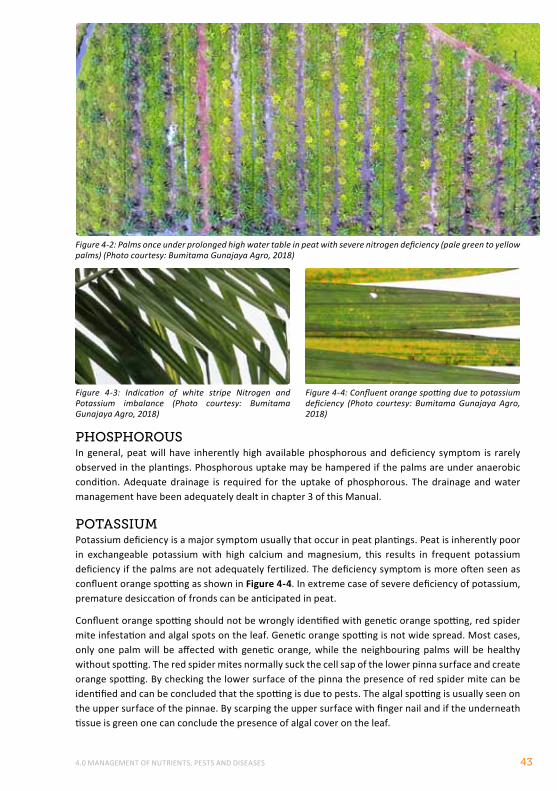
4.0 MANAGEMENT OF NUTRIENTS, PESTS AND DISEASES 43
phoSphorouSIn general, peat will have inherently high available phosphorous and deficiency symptom is rarely observed in the plantings. Phosphorous uptake may be hampered if the palms are under anaerobic condition. Adequate drainage is required for the uptake of phosphorous. The drainage and water management have been adequately dealt in chapter 3 of this Manual.
potASSIumPotassium deficiency is a major symptom usually that occur in peat plantings. Peat is inherently poor in exchangeable potassium with high calcium and magnesium, this results in frequent potassium deficiency if the palms are not adequately fertilized. The deficiency symptom is more often seen as confluent orange spotting as shown in Figure 4-4. In extreme case of severe deficiency of potassium, premature desiccation of fronds can be anticipated in peat.
Confluent orange spotting should not be wrongly identified with genetic orange spotting, red spider mite infestation and algal spots on the leaf. Genetic orange spotting is not wide spread. Most cases, only one palm will be affected with genetic orange, while the neighbouring palms will be healthy without spotting. The red spider mites normally suck the cell sap of the lower pinna surface and create orange spotting. By checking the lower surface of the pinna the presence of red spider mite can be identified and can be concluded that the spotting is due to pests. The algal spotting is usually seen on the upper surface of the pinnae. By scarping the upper surface with finger nail and if the underneath tissue is green one can conclude the presence of algal cover on the leaf.
Figure 4-2: Palms once under prolonged high water table in peat with severe nitrogen deficiency (pale green to yellow palms) (Photo courtesy: Bumitama Gunajaya Agro, 2018)
Figure 4-4: Confluent orange spotting due to potassium deficiency (Photo courtesy: Bumitama Gunajaya Agro, 2018)
Figure 4-3: Indication of white stripe Nitrogen and Potassium imbalance (Photo courtesy: Bumitama Gunajaya Agro, 2018)
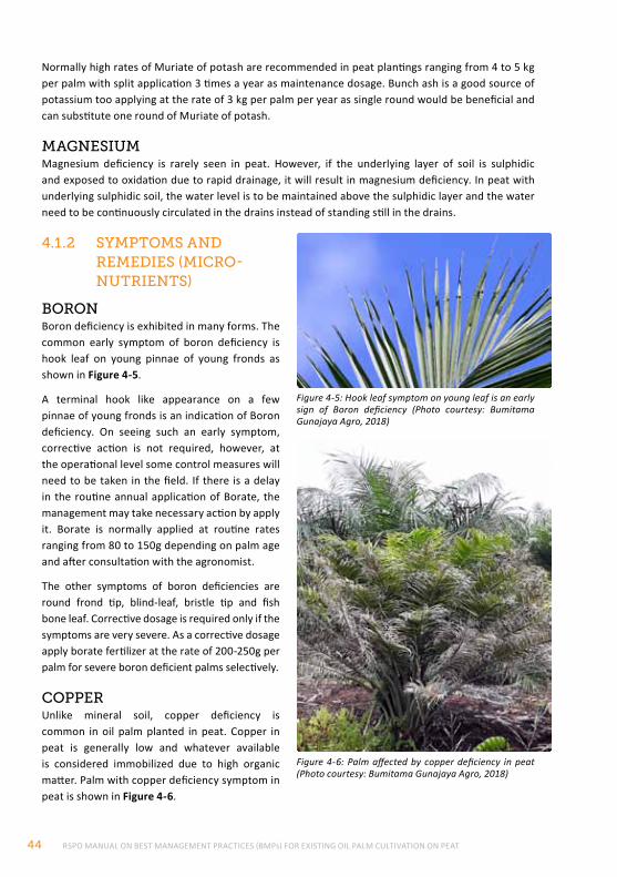
RSPO MANUAL ON BEST MANAGEMENT PRACTICES (BMPs) FOR EXISTING OIL PALM CULTIVATION ON PEAT44
Normally high rates of Muriate of potash are recommended in peat plantings ranging from 4 to 5 kg per palm with split application 3 times a year as maintenance dosage. Bunch ash is a good source of potassium too applying at the rate of 3 kg per palm per year as single round would be beneficial and can substitute one round of Muriate of potash.
mAgneSIumMagnesium deficiency is rarely seen in peat. However, if the underlying layer of soil is sulphidic and exposed to oxidation due to rapid drainage, it will result in magnesium deficiency. In peat with underlying sulphidic soil, the water level is to be maintained above the sulphidic layer and the water need to be continuously circulated in the drains instead of standing still in the drains.
4.1.2 SYmptomS And remedIeS (mIcro-nutrIentS)
BoronBoron deficiency is exhibited in many forms. The common early symptom of boron deficiency is hook leaf on young pinnae of young fronds as shown in Figure 4-5.
A terminal hook like appearance on a few pinnae of young fronds is an indication of Boron deficiency. On seeing such an early symptom, corrective action is not required, however, at the operational level some control measures will need to be taken in the field. If there is a delay in the routine annual application of Borate, the management may take necessary action by apply it. Borate is normally applied at routine rates ranging from 80 to 150g depending on palm age and after consultation with the agronomist.
The other symptoms of boron deficiencies are round frond tip, blind-leaf, bristle tip and fish bone leaf. Corrective dosage is required only if the symptoms are very severe. As a corrective dosage apply borate fertilizer at the rate of 200-250g per palm for severe boron deficient palms selectively.
copperUnlike mineral soil, copper deficiency is common in oil palm planted in peat. Copper in peat is generally low and whatever available is considered immobilized due to high organic matter. Palm with copper deficiency symptom in peat is shown in Figure 4-6.
Figure 4-5: Hook leaf symptom on young leaf is an early sign of Boron deficiency (Photo courtesy: Bumitama Gunajaya Agro, 2018)
Figure 4-6: Palm affected by copper deficiency in peat (Photo courtesy: Bumitama Gunajaya Agro, 2018)
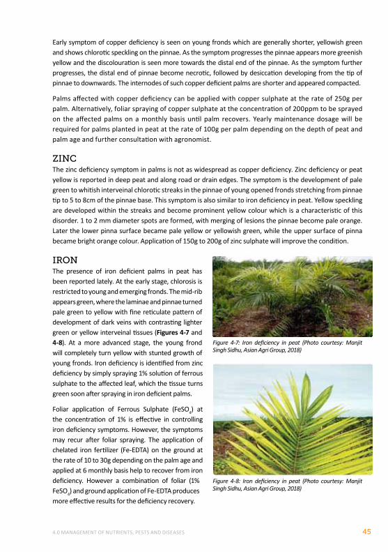
4.0 MANAGEMENT OF NUTRIENTS, PESTS AND DISEASES 45
Early symptom of copper deficiency is seen on young fronds which are generally shorter, yellowish green and shows chlorotic speckling on the pinnae. As the symptom progresses the pinnae appears more greenish yellow and the discolouration is seen more towards the distal end of the pinnae. As the symptom further progresses, the distal end of pinnae become necrotic, followed by desiccation developing from the tip of pinnae to downwards. The internodes of such copper deficient palms are shorter and appeared compacted.
Palms affected with copper deficiency can be applied with copper sulphate at the rate of 250g per palm. Alternatively, foliar spraying of copper sulphate at the concentration of 200ppm to be sprayed on the affected palms on a monthly basis until palm recovers. Yearly maintenance dosage will be required for palms planted in peat at the rate of 100g per palm depending on the depth of peat and palm age and further consultation with agronomist.
ZIncThe zinc deficiency symptom in palms is not as widespread as copper deficiency. Zinc deficiency or peat yellow is reported in deep peat and along road or drain edges. The symptom is the development of pale green to whitish interveinal chlorotic streaks in the pinnae of young opened fronds stretching from pinnae tip to 5 to 8cm of the pinnae base. This symptom is also similar to iron deficiency in peat. Yellow speckling are developed within the streaks and become prominent yellow colour which is a characteristic of this disorder. 1 to 2 mm diameter spots are formed, with merging of lesions the pinnae become pale orange. Later the lower pinna surface became pale yellow or yellowish green, while the upper surface of pinna became bright orange colour. Application of 150g to 200g of zinc sulphate will improve the condition.
IronThe presence of iron deficient palms in peat has been reported lately. At the early stage, chlorosis is restricted to young and emerging fronds. The mid-rib appears green, where the laminae and pinnae turned pale green to yellow with fine reticulate pattern of development of dark veins with contrasting lighter green or yellow interveinal tissues (Figures 4-7 and 4-8). At a more advanced stage, the young frond will completely turn yellow with stunted growth of young fronds. Iron deficiency is identified from zinc deficiency by simply spraying 1% solution of ferrous sulphate to the affected leaf, which the tissue turns green soon after spraying in iron deficient palms.
Foliar application of Ferrous Sulphate (FeSO4) at the concentration of 1% is effective in controlling iron deficiency symptoms. However, the symptoms may recur after foliar spraying. The application of chelated iron fertilizer (Fe-EDTA) on the ground at the rate of 10 to 30g depending on the palm age and applied at 6 monthly basis help to recover from iron deficiency. However a combination of foliar (1% FeSO4) and ground application of Fe-EDTA produces more effective results for the deficiency recovery.
Figure 4-7: Iron deficiency in peat (Photo courtesy: Manjit Singh Sidhu, Asian Agri Group, 2018)
Figure 4-8: Iron deficiency in peat (Photo courtesy: Manjit Singh Sidhu, Asian Agri Group, 2018)
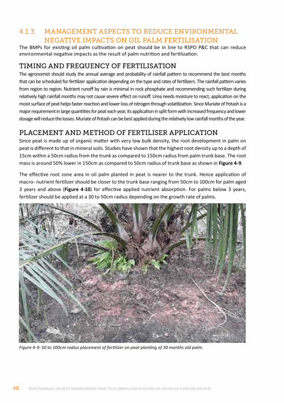
RSPO MANUAL ON BEST MANAGEMENT PRACTICES (BMPs) FOR EXISTING OIL PALM CULTIVATION ON PEAT46
4.1.3 mAnAgement ASpectS to reduce envIronmentAl negAtIve ImpActS on oIl pAlm fertIlISAtIon
The BMPs for existing oil palm cultivation on peat should be in line to RSPO P&C that can reduce environmental negative impacts as the result of palm nutrition and fertilization.
tImIng And freQuencY of fertIlISAtIonThe agronomist should study the annual average and probability of rainfall pattern to recommend the best months that can be scheduled for fertilizer application depending on the type and rates of fertilizers. The rainfall pattern varies from region to region. Nutrient runoff by rain is minimal in rock phosphate and recommending such fertilizer during relatively high rainfall months may not cause severe effect on runoff. Urea needs moisture to react, application on the moist surface of peat helps faster reaction and lower loss of nitrogen through volatilization. Since Muriate of Potash is a major requirement in large quantities for peat each year, its application in split form with increased frequency and lower dosage will reduce the losses. Muriate of Potash can be best applied during the relatively low rainfall months of the year.
plAcement And method of fertIlISer ApplIcAtIonSince peat is made up of organic matter with very low bulk density, the root development in palm on peat is different to that in mineral soils. Studies have shown that the highest root density up to a depth of 15cm within a 50cm radius from the trunk as compared to 150cm radius from palm trunk base. The root mass is around 50% lower in 150cm as compared to 50cm radius of trunk base as shown in Figure 4-9.
The effective root zone area in oil palm planted in peat is nearer to the trunk. Hence application of macro- nutrient fertilizer should be closer to the trunk base ranging from 50cm to 100cm for palm aged 3 years and above (Figure 4-10) for effective applied nutrient absorption. For palms below 3 years, fertilizer should be applied at a 30 to 50cm radius depending on the growth rate of palms.
Figure 4-9: 50 to 100cm radius placement of fertilizer on peat planting of 30 months old palm.
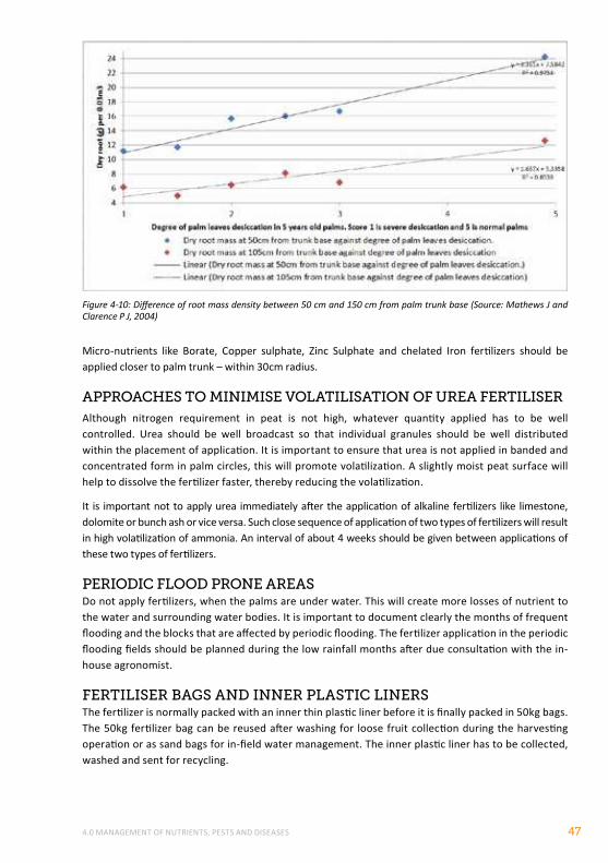
4.0 MANAGEMENT OF NUTRIENTS, PESTS AND DISEASES 47
Figure 4-10: Difference of root mass density between 50 cm and 150 cm from palm trunk base (Source: Mathews J and Clarence P J, 2004)
Micro-nutrients like Borate, Copper sulphate, Zinc Sulphate and chelated Iron fertilizers should be applied closer to palm trunk – within 30cm radius.
ApproAcheS to mInImISe volAtIlISAtIon of ureA fertIlISerAlthough nitrogen requirement in peat is not high, whatever quantity applied has to be well controlled. Urea should be well broadcast so that individual granules should be well distributed within the placement of application. It is important to ensure that urea is not applied in banded and concentrated form in palm circles, this will promote volatilization. A slightly moist peat surface will help to dissolve the fertilizer faster, thereby reducing the volatilization.
It is important not to apply urea immediately after the application of alkaline fertilizers like limestone, dolomite or bunch ash or vice versa. Such close sequence of application of two types of fertilizers will result in high volatilization of ammonia. An interval of about 4 weeks should be given between applications of these two types of fertilizers.
perIodIc flood prone AreASDo not apply fertilizers, when the palms are under water. This will create more losses of nutrient to the water and surrounding water bodies. It is important to document clearly the months of frequent flooding and the blocks that are affected by periodic flooding. The fertilizer application in the periodic flooding fields should be planned during the low rainfall months after due consultation with the in-house agronomist.
fertIlISer BAgS And Inner plAStIc lInerSThe fertilizer is normally packed with an inner thin plastic liner before it is finally packed in 50kg bags. The 50kg fertilizer bag can be reused after washing for loose fruit collection during the harvesting operation or as sand bags for in-field water management. The inner plastic liner has to be collected, washed and sent for recycling.
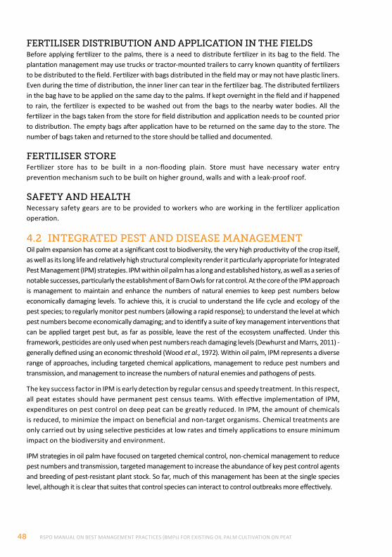
RSPO MANUAL ON BEST MANAGEMENT PRACTICES (BMPs) FOR EXISTING OIL PALM CULTIVATION ON PEAT48
fertIlISer dIStrIButIon And ApplIcAtIon In the fIeldSBefore applying fertilizer to the palms, there is a need to distribute fertilizer in its bag to the field. The plantation management may use trucks or tractor-mounted trailers to carry known quantity of fertilizers to be distributed to the field. Fertilizer with bags distributed in the field may or may not have plastic liners. Even during the time of distribution, the inner liner can tear in the fertilizer bag. The distributed fertilizers in the bag have to be applied on the same day to the palms. If kept overnight in the field and if happened to rain, the fertilizer is expected to be washed out from the bags to the nearby water bodies. All the fertilizer in the bags taken from the store for field distribution and application needs to be counted prior to distribution. The empty bags after application have to be returned on the same day to the store. The number of bags taken and returned to the store should be tallied and documented.
fertIlISer StoreFertilizer store has to be built in a non-flooding plain. Store must have necessary water entry prevention mechanism such to be built on higher ground, walls and with a leak-proof roof.
SAfetY And heAlthNecessary safety gears are to be provided to workers who are working in the fertilizer application operation.
4.2 IntegrAted peSt And dISeASe mAnAgementOil palm expansion has come at a significant cost to biodiversity, the very high productivity of the crop itself, as well as its long life and relatively high structural complexity render it particularly appropriate for Integrated Pest Management (IPM) strategies. IPM within oil palm has a long and established history, as well as a series of notable successes, particularly the establishment of Barn Owls for rat control. At the core of the IPM approach is management to maintain and enhance the numbers of natural enemies to keep pest numbers below economically damaging levels. To achieve this, it is crucial to understand the life cycle and ecology of the pest species; to regularly monitor pest numbers (allowing a rapid response); to understand the level at which pest numbers become economically damaging; and to identify a suite of key management interventions that can be applied target pest but, as far as possible, leave the rest of the ecosystem unaffected. Under this framework, pesticides are only used when pest numbers reach damaging levels (Dewhurst and Marrs, 2011) - generally defined using an economic threshold (Wood et al., 1972). Within oil palm, IPM represents a diverse range of approaches, including targeted chemical applications, management to reduce pest numbers and transmission, and management to increase the numbers of natural enemies and pathogens of pests.
The key success factor in IPM is early detection by regular census and speedy treatment. In this respect, all peat estates should have permanent pest census teams. With effective implementation of IPM, expenditures on pest control on deep peat can be greatly reduced. In IPM, the amount of chemicals is reduced, to minimize the impact on beneficial and non-target organisms. Chemical treatments are only carried out by using selective pesticides at low rates and timely applications to ensure minimum impact on the biodiversity and environment.
IPM strategies in oil palm have focused on targeted chemical control, non-chemical management to reduce pest numbers and transmission, targeted management to increase the abundance of key pest control agents and breeding of pest-resistant plant stock. So far, much of this management has been at the single species level, although it is clear that suites that control species can interact to control outbreaks more effectively.
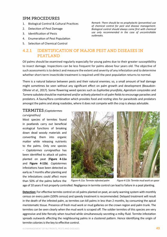
4.0 MANAGEMENT OF NUTRIENTS, PESTS AND DISEASES 49
Ipm procedureS1. Biological Control & Cultural Practices2. Detection of Pest Damage3. Identification of Pests4. Enumeration of Pest Population5. Selection of Chemical Control
4.2.1 IdentIfIcAtIon of mAJor peSt And dISeASeS In peAtlAnd
Oil palms should be examined regularly especially for young palms due to their greater susceptibility to insect damage. Inspections can be less frequent for palms above four years old. The objective of such assessments is to detect and measure the extent and severity of any infestation and to determine whether short-term insecticide treatment is required until the pest population returns to normal.
There is a natural balance between pests and their natural enemies; so, a small amount of leaf damage might sometimes be seen without any significant effect on palm growth and development (Beaudoin-Ollivier et al., 2017). Some flowering weed species such as Euphorbia prunifolia, Ageratum conyzoides and Turnera subulata should be maintained and/or actively planted in oil palm fields to encourage parasites and predators. A fauna/flora combination which provides food and resting sites for parasitoids and predators amongst the palms and along roadsides, where it does not compete with the crop is always advisable.
termIteS (Captotermes curvignathus)Most species of termites found in peatlands carry out beneficial ecological functions of breaking down dead woody materials and converting them into organic matter while releasing nutrients to the palms. Only one species – Captotermes curvignathus has been identified to attack oil palms planted on peat (Figure 4-11a and Figure 4-11b). Captotermes infestations have been detected as early as 7 months after planting and the infestations could affect more than 50% of the palms before the age of 10 years if not properly controlled. Negligence in termite control can lead to failure in a peat planting.
Detection: For effective termite control on oil palms planted on peat, an early warning system with monthly census on every palm (100% census) and speedy treatment is recommended. Delayed treatment will result in the death of the infested palm, as termites can kill palms in less than 2 months, by consuming the apical meristematic tissue. Presence of fresh mud work or mud galleries on the crown region and palm trunk. The termites can be seen clearly when the mud work is scraped off. The soldier termites of this species are very aggressive and bite fiercely when touched while simultaneously secreting a milky fluid. Termite infestation spreads outwards affecting the neighbouring palms in a clustered pattern. Hence identifying the origin of termite colonies is the key to effective control.
Figure 4-11a: Termite infested palm Figure 4-11b: Termite mud work on spear
Remark: There should be no prophylactic (preventive) use of chemical control for pest and disease management. Biological control should always come first with chemical use only recommended in the case of uncontrollable outbreaks.
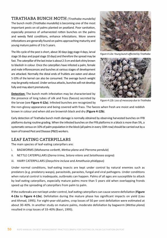
RSPO MANUAL ON BEST MANAGEMENT PRACTICES (BMPs) FOR EXISTING OIL PALM CULTIVATION ON PEAT50
tIrAthABA Bunch moth (Tirathaba mundella)The bunch moth (Tirathaba mundella) is becoming one of the most important pests on oil palms planted on peatland. Poor sanitation, especially presence of unharvested rotten bunches on the palms and weedy field conditions, enhance infestations. More severe infestations are generally found on palms approaching maturity and young mature palms of 3 to 5 years.
The life-cycle of the pest is short, about 30 days (egg stage 4 days, larval stage 16 days and pupal stage 10 days) and therefore the spread may be fast. The caterpillar of the last instar is about 2-3 cm and dark shiny brown to blackish in colour. Once the caterpillars have infested a palm, female and male inflorescences and bunches at various stages of development are attacked. Normally the distal ends of fruitlets are eaten and about 5-10% of the kernel can also be consumed. The average bunch weight may be greatly reduced. Under serious attacks, bunches will not develop fully and may abort prematurely.
Detection: The bunch moth infestation may be characterized by the presence of long tubes of silk and frass (faeces) secreted by the larvae (see Figure 4-12a). Infested bunches are recognized by the non-glossy appearance and being covered with frass. The faeces when fresh are moist and reddish brown in colour and when old are brownish black and dry (Figure 4-12b).
Early detection of Tirathaba bunch moth damage is normally obtained by observing harvested bunches on FFB platforms during routine grading. When the infested bunches on the FFB platforms in a block is more than 5%, a systematic census on 10% of palm population in the block (all palms in every 10th row) should be carried out by a team of trained Pest and Disease (P&D) workers.
leAf eAtIng cAterpIllArSThe main species of leaf-eating caterpillars are:
i. BAGWORMS (Mahasena corbetti, Metisa plana and Pteroma pendula)
ii. NETTLE CATERPILLARS (Darna trima, Setora nitens and Setothosea asigna)
iii. HAIRY CATERPILLARS (Dasychira inclusa and Amathusia phidippus)
Under normal conditions, leaf-eating insects are kept under control by natural enemies such as predators (e.g. predatory wasps), parasitoids, parasites, fungal and viral pathogens. Under conditions when natural control is inadequate, outbreaks can happen. Palms of all ages are susceptible to attack by leaf-eating caterpillars, especially mature palms more than 5 years old when overlapping fronds speed up the spreading of caterpillars from palm to palm.
If the outbreaks are not kept under control, leaf eating caterpillars can cause severe defoliation (Figure 4-13a to Figure 4-13e). Defoliation during the mature phase has significant impacts on yield (Liau and Ahmad, 1995). For eight-year-old palms, crop losses of 50 per cent defoliation were estimated at about 30-40%. In another study on mature palms, moderate defoliation by bagworm (Metisa plana) resulted in crop losses of 33-40% (Basri, 1995).
Figure 4-12a: Young bunch affected by Tirathaba
Figure 4-12b: Loss of mesocarp due to Tirathaba
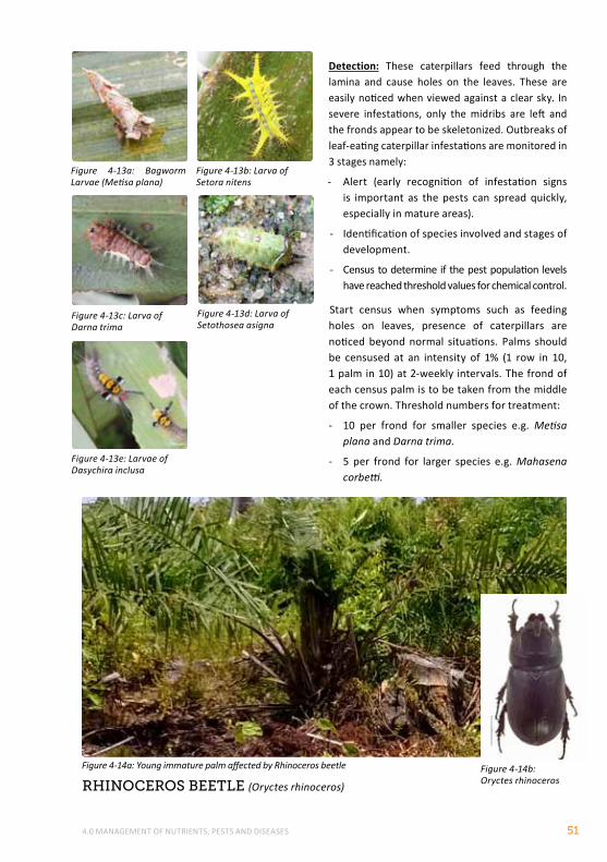
4.0 MANAGEMENT OF NUTRIENTS, PESTS AND DISEASES 51
Detection: These caterpillars feed through the lamina and cause holes on the leaves. These are easily noticed when viewed against a clear sky. In severe infestations, only the midribs are left and the fronds appear to be skeletonized. Outbreaks of leaf-eating caterpillar infestations are monitored in 3 stages namely:
- Alert (early recognition of infestation signs is important as the pests can spread quickly, especially in mature areas).
- Identification of species involved and stages of development.
- Census to determine if the pest population levels have reached threshold values for chemical control.
Start census when symptoms such as feeding holes on leaves, presence of caterpillars are noticed beyond normal situations. Palms should be censused at an intensity of 1% (1 row in 10, 1 palm in 10) at 2-weekly intervals. The frond of each census palm is to be taken from the middle of the crown. Threshold numbers for treatment:
- 10 per frond for smaller species e.g. Metisa plana and Darna trima.
- 5 per frond for larger species e.g. Mahasena corbetti.
rhInoceroS Beetle (Oryctes rhinoceros)
Figure 4-13b: Larva of Setora nitens
Figure 4-13a: Bagworm Larvae (Metisa plana)
Figure 4-13d: Larva of Setothosea asigna
Figure 4-13c: Larva of Darna trima
Figure 4-13e: Larvae of Dasychira inclusa
Figure 4-14a: Young immature palm affected by Rhinoceros beetle Figure 4-14b: Oryctes rhinoceros
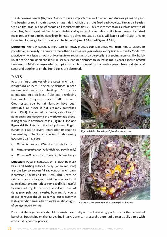
RSPO MANUAL ON BEST MANAGEMENT PRACTICES (BMPs) FOR EXISTING OIL PALM CULTIVATION ON PEAT52
The rhinoceros beetle (Oryctes rhinoceros) is an important insect pest of immature oil palms on peat. The beetles breed in rotting woody materials in which the grubs feed and develop. The adult beetles feed on the basal region of spears and meristematic tissue. This causes symptoms such as new frond snapping, fan-shaped cut fronds, and dieback of spear and bore holes on the frond bases. If control measures are not applied quickly on immature palms, repeated attacks will lead to palm death, arising from direct damage to the meristematic tissue (Figure 4-14a and Figure 4-14b).
Detection: Monthly census is important for newly planted palms in areas with high rhinoceros beetle population, especially in areas with more than 2 successive years of replanting (especially with “no-burn” practice) where large amount of biomass from replanting provide excellent breeding grounds. The build-up of beetle population can result in serious repeated damage to young palms. A census should record the onset of NEW damages when symptoms such fan-shaped cut on newly opened fronds, dieback of spear and bore holes on the frond bases are observed.
rAtSRats are important vertebrate pests in oil palm plantations on peat. They cause damage in both mature and immature plantings. On mature palms, rats feed on loose fruits and developing fruit bunches. They also attack the inflorescences. Crop losses due to rat damage have been estimated at 7-10% if not properly controlled (Liau, 1994). For immature palms, rats chew on palm bases and consume the meristematic tissue, killing them in advanced cases (Figure 4-15a and Figure 4-15b). Rats also attack oil palm seedlings in nurseries, causing severe retardation or death to the seedlings. The 3 main species of rats causing economic damage are:
i. Rattus tiomanicus (Wood rat, white belly)
ii. Rattus argentiventer (Paddy field rat, grayish belly)
iii. Rattus rattus diardii (House rat, brown belly)
Detection: Regular censuses on a block-by-block basis and baiting without delay (when required) are the key to successful rat control in oil palm plantations (Chung and Sim, 1994). This is because rats with access to good nutrition sources in oil palm plantations reproduce very rapidly. It is useful to carry out regular censuses based on fresh rat damage on palms or harvested bunches. For young palms, censuses should be carried out monthly in high infestation areas when their bases show signs of being chewed by rats.
Fresh rat damage census should be carried out daily on the harvesting platforms on the harvested bunches. Depending on the harvesting interval, one can assess the extent of damage daily along with crop quality control process.
Figure 4-15a: Gnawing of frond base by rats.
Figure 4-15b: Damage of oil palm fruits by rats.
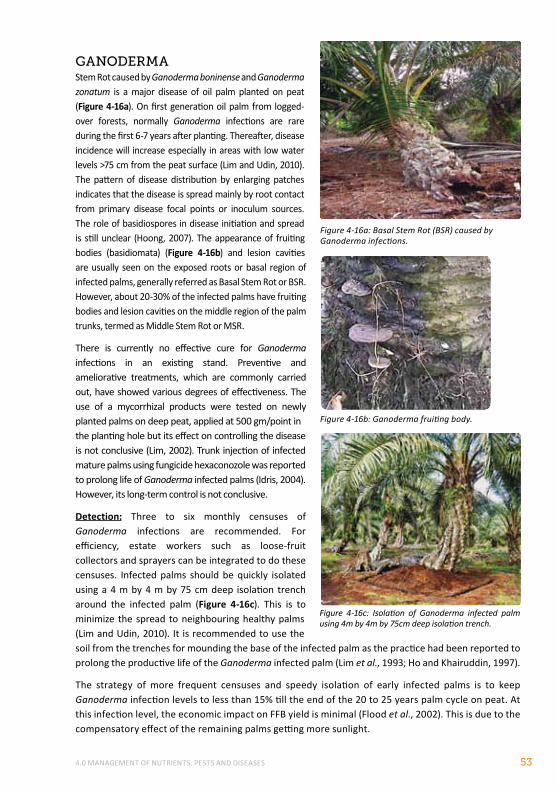
4.0 MANAGEMENT OF NUTRIENTS, PESTS AND DISEASES 53
gAnodermAStem Rot caused by Ganoderma boninense and Ganoderma zonatum is a major disease of oil palm planted on peat (Figure 4-16a). On first generation oil palm from logged-over forests, normally Ganoderma infections are rare during the first 6-7 years after planting. Thereafter, disease incidence will increase especially in areas with low water levels >75 cm from the peat surface (Lim and Udin, 2010). The pattern of disease distribution by enlarging patches indicates that the disease is spread mainly by root contact from primary disease focal points or inoculum sources. The role of basidiospores in disease initiation and spread is still unclear (Hoong, 2007). The appearance of fruiting bodies (basidiomata) (Figure 4-16b) and lesion cavities are usually seen on the exposed roots or basal region of infected palms, generally referred as Basal Stem Rot or BSR. However, about 20-30% of the infected palms have fruiting bodies and lesion cavities on the middle region of the palm trunks, termed as Middle Stem Rot or MSR.
There is currently no effective cure for Ganoderma infections in an existing stand. Preventive and ameliorative treatments, which are commonly carried out, have showed various degrees of effectiveness. The use of a mycorrhizal products were tested on newly planted palms on deep peat, applied at 500 gm/point in the planting hole but its effect on controlling the disease is not conclusive (Lim, 2002). Trunk injection of infected mature palms using fungicide hexaconozole was reported to prolong life of Ganoderma infected palms (Idris, 2004). However, its long-term control is not conclusive.
Detection: Three to six monthly censuses of Ganoderma infections are recommended. For efficiency, estate workers such as loose-fruit collectors and sprayers can be integrated to do these censuses. Infected palms should be quickly isolated using a 4 m by 4 m by 75 cm deep isolation trench around the infected palm (Figure 4-16c). This is to minimize the spread to neighbouring healthy palms (Lim and Udin, 2010). It is recommended to use the soil from the trenches for mounding the base of the infected palm as the practice had been reported to prolong the productive life of the Ganoderma infected palm (Lim et al., 1993; Ho and Khairuddin, 1997).
The strategy of more frequent censuses and speedy isolation of early infected palms is to keep Ganoderma infection levels to less than 15% till the end of the 20 to 25 years palm cycle on peat. At this infection level, the economic impact on FFB yield is minimal (Flood et al., 2002). This is due to the compensatory effect of the remaining palms getting more sunlight.
Figure 4-16a: Basal Stem Rot (BSR) caused by Ganoderma infections.
Figure 4-16b: Ganoderma fruiting body.
Figure 4-16c: Isolation of Ganoderma infected palm using 4m by 4m by 75cm deep isolation trench.
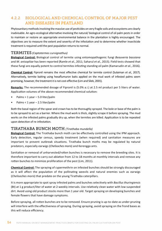
RSPO MANUAL ON BEST MANAGEMENT PRACTICES (BMPs) FOR EXISTING OIL PALM CULTIVATION ON PEAT54
4.2.2 BIologIcAl And chemIcAl control of mAJor peSt And dISeASeS In peAtlAnd
Phytosanitary methods involving the massive use of pesticides on very fragile soils and ecosystems are clearly inadvisable. An agro-ecological alternative involving the natural/ biological control of oil palm pests in order to maintain or restore an appropriate environmental balance in the plantation is highly encouraged. The objectives are to measure the extent and severity of the infestation and to determine whether insecticide treatment is required until the pest population returns to normal.
termIteS (Captotermes curvignathus)Biological Control: Biological control of termite using entomopathogenic fungi Beauveria bassiana and M. anisopliae has been reported (Ramle et al., 2011; Saharul et al., 2015). Field tests showed that these fungi are equally potent to control termites infesting standing oil palm (Kamarudin et al., 2016).
Chemical Control: Fipronil remains the most effective chemical for termite control (Sulaiman et al., 2017). Alternatively, termite baiting using hexaflumuron baits applied on the mud work of infested palms seem promising, however, the treatment it is not cost-effective (Lim and Silek, 2001).
Remarks: The recommended dosage of Fipronil is (5.0% a.i.) at 2.5 ml product per 5 liters of water. Application volumes of the above recommended chemical solution:
• Palms > 1 year – 5.0 liter/palm
• Palms < 1 year – 2.5 liter/palm
Both the basal region of the spear and crown has to be thoroughly sprayed. The bole or base of the palm is to be sprayed to act as a barrier. Where the mud work is thick, slightly scrape it before spraying. The mud works on the infested palms gradually dry up, when the termites are killed. Application is to be repeated upon detection of re-infestation.
tIrAthABA Bunch moth (Tirathaba mundella)Biological Control: The Tirathaba bunch moth can be effectively controlled using the IPM approach. Early detection, regular census, speedy treatment (when required) and sanitation measures are important to prevent outbreak situations. Tirathaba bunch moths may be regulated by natural predators, especially earwigs (Chelisoches moris) and Kerengga ants.
Sanitation or removal of unharvested/rotten bunches is necessary to remove the breeding sites. It is therefore important to carry out ablation from 12 to 18 months at monthly intervals and remove any rotten bunches to minimize proliferation of the pest (Lim, 2011).
Chemical Control: The spraying of cypermethrin on infested bunches should be strongly discouraged as it will affect the population of the pollinating weevils and natural enemies such as earwigs (Chelisoches moris) that predate on the young Tirathaba caterpillars.
It is more appropriate to spot spray infested palms and bunches selectively with Bacillus thuringiensis (Bt) at 1 g product/liter of water at 2-weekly intervals. Use relatively clean water with low suspended dirt. Avoid using old product stocks more than 1 year old. Target spraying on developing bunches and female flowers that have damage symptoms.
Before spraying, all rotten bunches are to be removed. Ensure pruning is up-to-date as under-pruning will interfere with the effectiveness of spraying. During spraying, avoid spraying on the frond bases as this will reduce efficiency.
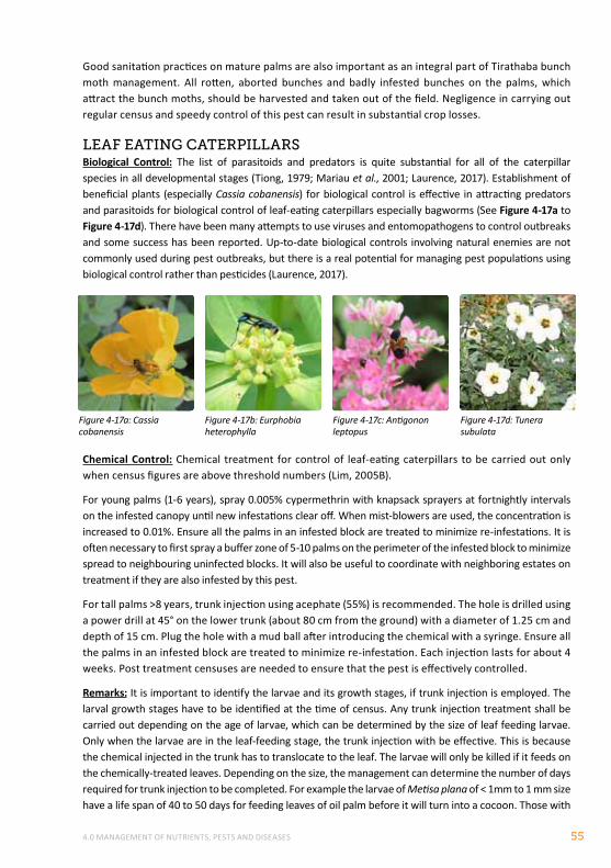
4.0 MANAGEMENT OF NUTRIENTS, PESTS AND DISEASES 55
Good sanitation practices on mature palms are also important as an integral part of Tirathaba bunch moth management. All rotten, aborted bunches and badly infested bunches on the palms, which attract the bunch moths, should be harvested and taken out of the field. Negligence in carrying out regular census and speedy control of this pest can result in substantial crop losses.
leAf eAtIng cAterpIllArSBiological Control: The list of parasitoids and predators is quite substantial for all of the caterpillar species in all developmental stages (Tiong, 1979; Mariau et al., 2001; Laurence, 2017). Establishment of beneficial plants (especially Cassia cobanensis) for biological control is effective in attracting predators and parasitoids for biological control of leaf-eating caterpillars especially bagworms (See Figure 4-17a to Figure 4-17d). There have been many attempts to use viruses and entomopathogens to control outbreaks and some success has been reported. Up-to-date biological controls involving natural enemies are not commonly used during pest outbreaks, but there is a real potential for managing pest populations using biological control rather than pesticides (Laurence, 2017).
Chemical Control: Chemical treatment for control of leaf-eating caterpillars to be carried out only when census figures are above threshold numbers (Lim, 2005B).
For young palms (1-6 years), spray 0.005% cypermethrin with knapsack sprayers at fortnightly intervals on the infested canopy until new infestations clear off. When mist-blowers are used, the concentration is increased to 0.01%. Ensure all the palms in an infested block are treated to minimize re-infestations. It is often necessary to first spray a buffer zone of 5-10 palms on the perimeter of the infested block to minimize spread to neighbouring uninfected blocks. It will also be useful to coordinate with neighboring estates on treatment if they are also infested by this pest.
For tall palms >8 years, trunk injection using acephate (55%) is recommended. The hole is drilled using a power drill at 45° on the lower trunk (about 80 cm from the ground) with a diameter of 1.25 cm and depth of 15 cm. Plug the hole with a mud ball after introducing the chemical with a syringe. Ensure all the palms in an infested block are treated to minimize re-infestation. Each injection lasts for about 4 weeks. Post treatment censuses are needed to ensure that the pest is effectively controlled.
Remarks: It is important to identify the larvae and its growth stages, if trunk injection is employed. The larval growth stages have to be identified at the time of census. Any trunk injection treatment shall be carried out depending on the age of larvae, which can be determined by the size of leaf feeding larvae. Only when the larvae are in the leaf-feeding stage, the trunk injection with be effective. This is because the chemical injected in the trunk has to translocate to the leaf. The larvae will only be killed if it feeds on the chemically-treated leaves. Depending on the size, the management can determine the number of days required for trunk injection to be completed. For example the larvae of Metisa plana of < 1mm to 1 mm size have a life span of 40 to 50 days for feeding leaves of oil palm before it will turn into a cocoon. Those with
Figure 4-17a: Cassia cobanensis
Figure 4-17b: Eurphobia heterophylla
Figure 4-17c: Antigonon leptopus
Figure 4-17d: Tunera subulata
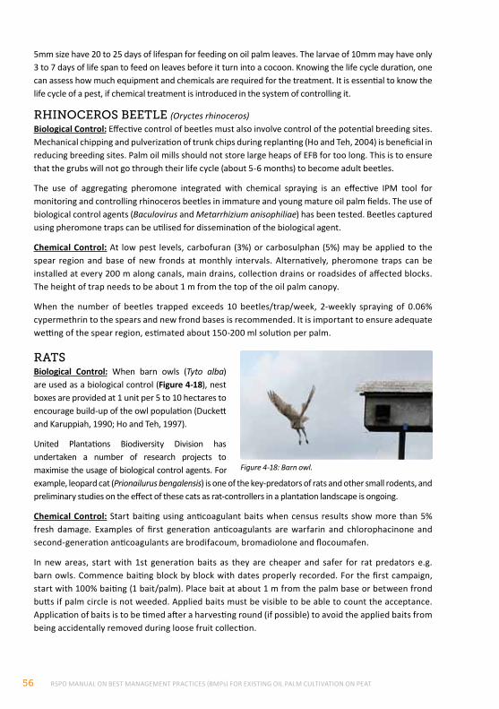
RSPO MANUAL ON BEST MANAGEMENT PRACTICES (BMPs) FOR EXISTING OIL PALM CULTIVATION ON PEAT56
5mm size have 20 to 25 days of lifespan for feeding on oil palm leaves. The larvae of 10mm may have only 3 to 7 days of life span to feed on leaves before it turn into a cocoon. Knowing the life cycle duration, one can assess how much equipment and chemicals are required for the treatment. It is essential to know the life cycle of a pest, if chemical treatment is introduced in the system of controlling it.
rhInoceroS Beetle (Oryctes rhinoceros)Biological Control: Effective control of beetles must also involve control of the potential breeding sites. Mechanical chipping and pulverization of trunk chips during replanting (Ho and Teh, 2004) is beneficial in reducing breeding sites. Palm oil mills should not store large heaps of EFB for too long. This is to ensure that the grubs will not go through their life cycle (about 5-6 months) to become adult beetles.
The use of aggregating pheromone integrated with chemical spraying is an effective IPM tool for monitoring and controlling rhinoceros beetles in immature and young mature oil palm fields. The use of biological control agents (Baculovirus and Metarrhizium anisophiliae) has been tested. Beetles captured using pheromone traps can be utilised for dissemination of the biological agent.
Chemical Control: At low pest levels, carbofuran (3%) or carbosulphan (5%) may be applied to the spear region and base of new fronds at monthly intervals. Alternatively, pheromone traps can be installed at every 200 m along canals, main drains, collection drains or roadsides of affected blocks. The height of trap needs to be about 1 m from the top of the oil palm canopy.
When the number of beetles trapped exceeds 10 beetles/trap/week, 2-weekly spraying of 0.06% cypermethrin to the spears and new frond bases is recommended. It is important to ensure adequate wetting of the spear region, estimated about 150-200 ml solution per palm.
rAtSBiological Control: When barn owls (Tyto alba) are used as a biological control (Figure 4-18), nest boxes are provided at 1 unit per 5 to 10 hectares to encourage build-up of the owl population (Duckett and Karuppiah, 1990; Ho and Teh, 1997).
United Plantations Biodiversity Division has undertaken a number of research projects to maximise the usage of biological control agents. For example, leopard cat (Prionailurus bengalensis) is one of the key-predators of rats and other small rodents, and preliminary studies on the effect of these cats as rat-controllers in a plantation landscape is ongoing.
Chemical Control: Start baiting using anticoagulant baits when census results show more than 5% fresh damage. Examples of first generation anticoagulants are warfarin and chlorophacinone and second-generation anticoagulants are brodifacoum, bromadiolone and flocoumafen.
In new areas, start with 1st generation baits as they are cheaper and safer for rat predators e.g. barn owls. Commence baiting block by block with dates properly recorded. For the first campaign, start with 100% baiting (1 bait/palm). Place bait at about 1 m from the palm base or between frond butts if palm circle is not weeded. Applied baits must be visible to be able to count the acceptance. Application of baits is to be timed after a harvesting round (if possible) to avoid the applied baits from being accidentally removed during loose fruit collection.
Figure 4-18: Barn owl.
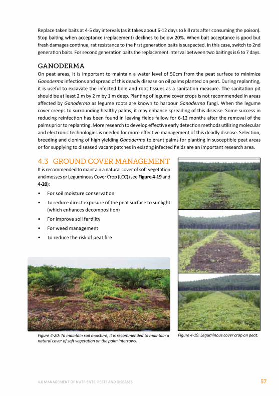
4.0 MANAGEMENT OF NUTRIENTS, PESTS AND DISEASES 57
Replace taken baits at 4-5 day intervals (as it takes about 6-12 days to kill rats after consuming the poison). Stop baiting when acceptance (replacement) declines to below 20%. When bait acceptance is good but fresh damages continue, rat resistance to the first generation baits is suspected. In this case, switch to 2nd generation baits. For second generation baits the replacement interval between two baitings is 6 to 7 days.
gAnodermAOn peat areas, it is important to maintain a water level of 50cm from the peat surface to minimize Ganoderma infections and spread of this deadly disease on oil palms planted on peat. During replanting, it is useful to excavate the infected bole and root tissues as a sanitation measure. The sanitation pit should be at least 2 m by 2 m by 1 m deep. Planting of legume cover crops is not recommended in areas affected by Ganoderma as legume roots are known to harbour Ganoderma fungi. When the legume cover creeps to surrounding healthy palms, it may enhance spreading of this disease. Some success in reducing reinfection has been found in leaving fields fallow for 6-12 months after the removal of the palms prior to replanting. More research to develop effective early detection methods utilizing molecular and electronic technologies is needed for more effective management of this deadly disease. Selection, breeding and cloning of high yielding Ganoderma tolerant palms for planting in susceptible peat areas or for supplying to diseased vacant patches in existing infected fields are an important research area.
4.3 ground cover mAnAgementIt is recommended to maintain a natural cover of soft vegetation and mosses or Leguminous Cover Crop (LCC) (see Figure 4-19 and 4-20):
• For soil moisture conservation
• To reduce direct exposure of the peat surface to sunlight (which enhances decomposition)
• For improve soil fertility
• For weed management
• To reduce the risk of peat fire
Figure 4-19: Leguminous cover crop on peat.Figure 4-20: To maintain soil moisture, it is recommended to maintain a natural cover of soft vegetation on the palm interrows.
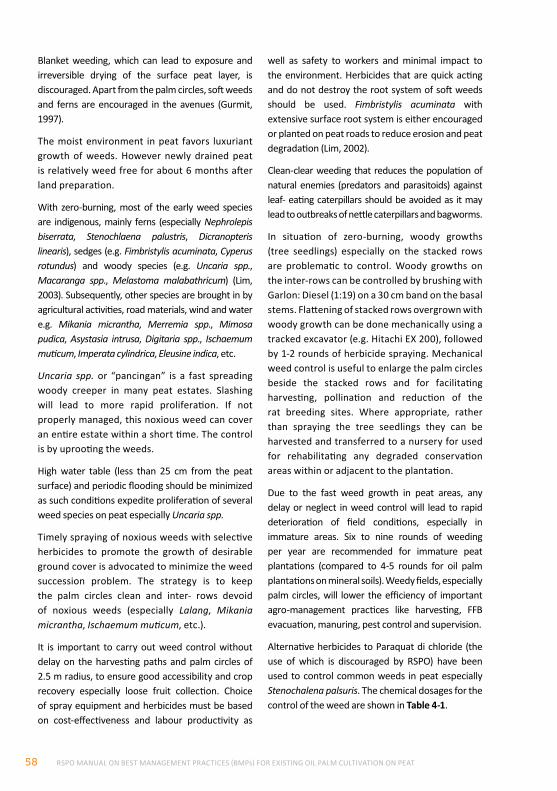
RSPO MANUAL ON BEST MANAGEMENT PRACTICES (BMPs) FOR EXISTING OIL PALM CULTIVATION ON PEAT58
Blanket weeding, which can lead to exposure and irreversible drying of the surface peat layer, is discouraged. Apart from the palm circles, soft weeds and ferns are encouraged in the avenues (Gurmit, 1997).
The moist environment in peat favors luxuriant growth of weeds. However newly drained peat is relatively weed free for about 6 months after land preparation.
With zero-burning, most of the early weed species are indigenous, mainly ferns (especially Nephrolepis biserrata, Stenochlaena palustris, Dicranopteris linearis), sedges (e.g. Fimbristylis acuminata, Cyperus rotundus) and woody species (e.g. Uncaria spp., Macaranga spp., Melastoma malabathricum) (Lim, 2003). Subsequently, other species are brought in by agricultural activities, road materials, wind and water e.g. Mikania micrantha, Merremia spp., Mimosa pudica, Asystasia intrusa, Digitaria spp., Ischaemum muticum, Imperata cylindrica, Eleusine indica, etc.
Uncaria spp. or “pancingan” is a fast spreading woody creeper in many peat estates. Slashing will lead to more rapid proliferation. If not properly managed, this noxious weed can cover an entire estate within a short time. The control is by uprooting the weeds.
High water table (less than 25 cm from the peat surface) and periodic flooding should be minimized as such conditions expedite proliferation of several weed species on peat especially Uncaria spp.
Timely spraying of noxious weeds with selective herbicides to promote the growth of desirable ground cover is advocated to minimize the weed succession problem. The strategy is to keep the palm circles clean and inter- rows devoid of noxious weeds (especially Lalang, Mikania micrantha, Ischaemum muticum, etc.).
It is important to carry out weed control without delay on the harvesting paths and palm circles of 2.5 m radius, to ensure good accessibility and crop recovery especially loose fruit collection. Choice of spray equipment and herbicides must be based on cost-effectiveness and labour productivity as
well as safety to workers and minimal impact to the environment. Herbicides that are quick acting and do not destroy the root system of soft weeds should be used. Fimbristylis acuminata with extensive surface root system is either encouraged or planted on peat roads to reduce erosion and peat degradation (Lim, 2002).
Clean-clear weeding that reduces the population of natural enemies (predators and parasitoids) against leaf- eating caterpillars should be avoided as it may lead to outbreaks of nettle caterpillars and bagworms.
In situation of zero-burning, woody growths (tree seedlings) especially on the stacked rows are problematic to control. Woody growths on the inter-rows can be controlled by brushing with Garlon: Diesel (1:19) on a 30 cm band on the basal stems. Flattening of stacked rows overgrown with woody growth can be done mechanically using a tracked excavator (e.g. Hitachi EX 200), followed by 1-2 rounds of herbicide spraying. Mechanical weed control is useful to enlarge the palm circles beside the stacked rows and for facilitating harvesting, pollination and reduction of the rat breeding sites. Where appropriate, rather than spraying the tree seedlings they can be harvested and transferred to a nursery for used for rehabilitating any degraded conservation areas within or adjacent to the plantation.
Due to the fast weed growth in peat areas, any delay or neglect in weed control will lead to rapid deterioration of field conditions, especially in immature areas. Six to nine rounds of weeding per year are recommended for immature peat plantations (compared to 4-5 rounds for oil palm plantations on mineral soils). Weedy fields, especially palm circles, will lower the efficiency of important agro-management practices like harvesting, FFB evacuation, manuring, pest control and supervision.
Alternative herbicides to Paraquat di chloride (the use of which is discouraged by RSPO) have been used to control common weeds in peat especially Stenochalena palsuris. The chemical dosages for the control of the weed are shown in Table 4-1.
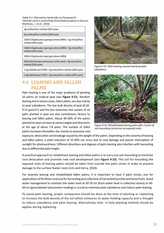
4.0 MANAGEMENT OF NUTRIENTS, PESTS AND DISEASES 59
Table 4-1: Alternative Herbicides to Paraquat Di Chloride used in controlling Stenochalena palsuris (Source: Mathews, J. et al., 2016)
3g methsufron methyl (20% w/w)
5g methsulfron methyl (20% w/w)
100ml Glyphosate isopropyl amine (48%) + 3g metsulfron methyl (20% w/w)
100ml Glyphosate isopropyl amine (48%) + 5g metsulfron methyl (20% w/w)
100ml Glyphosate isopropyl amine (48%)
30ml Glufosinate ammonium (15% w/w) + 3g metsulfron methyl (20% w/w)
2.5g Saflufenasil (70%) + 5g metsulfron methyl (20% w/w)
2.0g Saflufenasil (70%) + 5g metsulfron methyl (20% w/w)
4.4 leAnIng And fAllen pAlmS
Palm leaning is one of the major problems of planting oil palms on tropical peat (see Figure 4-21). Random leaning and in severe cases, fallen palms, are due mainly to peat subsidence. The low bulk density of peat (0.10-0.15 gm/cm3) and the less extensive root system of oil palm planted in peat are also contributory factors to leaning and fallen palms. About 40-50% of the palms planted on peat can lean at various angles and directions at the age of about 7-8 years. The number of fallen palms increases thereafter due mainly to excessive root exposure, desiccation and breakage caused by the weight of the palms. Depending on the severity of leaning and fallen palms, a yield reduction of 10-30% can occur due to root damage and poorer interception of sunlight for photosynthesis. Different directions and degrees of palm leaning also interfere with harvesting due to differential palm height.
A practical approach to rehabilitate leaning and fallen palms is to carry out soil mounding to minimize root desiccation and promote new root development (see Figure 4-22). The soil for mounding the exposed roots of leaning palms should be taken from outside the palm circles in order to prevent damage to the surface feeder roots (Lim and Herry, 2010).
For severely leaning and rehabilitated fallen palms, it is important to have 2 palm circles; one for applications of fertilizers and one for harvesting and collection of harvested bunches and loose fruits. Good water management to maintain the water level at 50-70 cm (from water level in collection drains) or 40-60 cm (groundwater piezometer reading) is crucial to minimize peat subsidence and reduce palm leaning.
To avoid palm leaning, proper compaction should be done at the time of planting or replanting to increase the bulk density of the soil which enhances its water holding capacity and is thought to reduce subsidence and palm leaning. Alternatively hole- in-hole planting method should be applies during replanting.
Figure 4-22: Rehabilitated leaning palm after 2 years of soil mounding carried out on exposed roots.
Figure 4-21: Palm leaning caused mainly by peat subsidence.
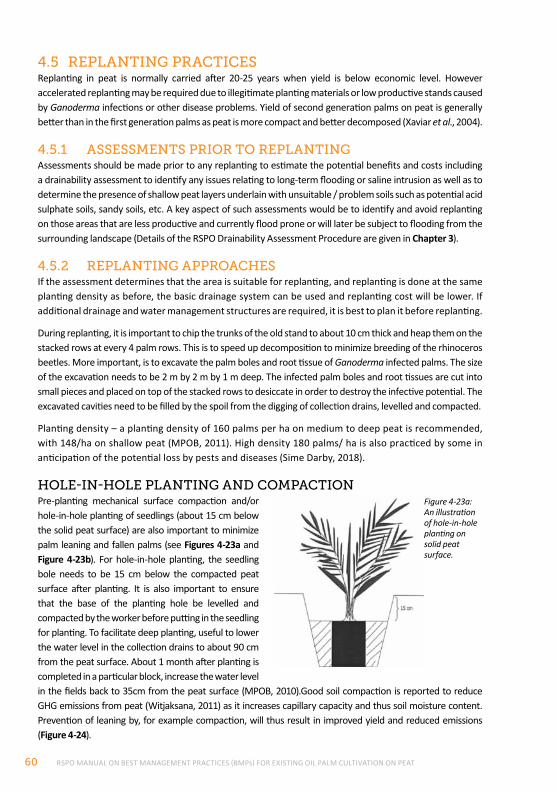
RSPO MANUAL ON BEST MANAGEMENT PRACTICES (BMPs) FOR EXISTING OIL PALM CULTIVATION ON PEAT60
4.5 replAntIng prActIceSReplanting in peat is normally carried after 20-25 years when yield is below economic level. However accelerated replanting may be required due to illegitimate planting materials or low productive stands caused by Ganoderma infections or other disease problems. Yield of second generation palms on peat is generally better than in the first generation palms as peat is more compact and better decomposed (Xaviar et al., 2004).
4.5.1 ASSeSSmentS prIor to replAntIngAssessments should be made prior to any replanting to estimate the potential benefits and costs including a drainability assessment to identify any issues relating to long-term flooding or saline intrusion as well as to determine the presence of shallow peat layers underlain with unsuitable / problem soils such as potential acid sulphate soils, sandy soils, etc. A key aspect of such assessments would be to identify and avoid replanting on those areas that are less productive and currently flood prone or will later be subject to flooding from the surrounding landscape (Details of the RSPO Drainability Assessment Procedure are given in Chapter 3).
4.5.2 replAntIng ApproAcheSIf the assessment determines that the area is suitable for replanting, and replanting is done at the same planting density as before, the basic drainage system can be used and replanting cost will be lower. If additional drainage and water management structures are required, it is best to plan it before replanting.
During replanting, it is important to chip the trunks of the old stand to about 10 cm thick and heap them on the stacked rows at every 4 palm rows. This is to speed up decomposition to minimize breeding of the rhinoceros beetles. More important, is to excavate the palm boles and root tissue of Ganoderma infected palms. The size of the excavation needs to be 2 m by 2 m by 1 m deep. The infected palm boles and root tissues are cut into small pieces and placed on top of the stacked rows to desiccate in order to destroy the infective potential. The excavated cavities need to be filled by the spoil from the digging of collection drains, levelled and compacted.
Planting density – a planting density of 160 palms per ha on medium to deep peat is recommended, with 148/ha on shallow peat (MPOB, 2011). High density 180 palms/ ha is also practiced by some in anticipation of the potential loss by pests and diseases (Sime Darby, 2018).
hole-In-hole plAntIng And compActIonPre-planting mechanical surface compaction and/or hole-in-hole planting of seedlings (about 15 cm below the solid peat surface) are also important to minimize palm leaning and fallen palms (see Figures 4-23a and Figure 4-23b). For hole-in-hole planting, the seedling bole needs to be 15 cm below the compacted peat surface after planting. It is also important to ensure that the base of the planting hole be levelled and compacted by the worker before putting in the seedling for planting. To facilitate deep planting, useful to lower the water level in the collection drains to about 90 cm from the peat surface. About 1 month after planting is completed in a particular block, increase the water level in the fields back to 35cm from the peat surface (MPOB, 2010).Good soil compaction is reported to reduce GHG emissions from peat (Witjaksana, 2011) as it increases capillary capacity and thus soil moisture content. Prevention of leaning by, for example compaction, will thus result in improved yield and reduced emissions (Figure 4-24).
Figure 4-23a: An illustration of hole-in-hole planting on solid peat surface.
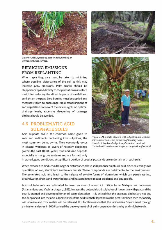
4.0 MANAGEMENT OF NUTRIENTS, PESTS AND DISEASES 61
reducIng emISSIonS from replAntIngWhen replanting, care must be taken to minimize, where possible, disturbance of the soil as this may increase GHG emissions. Palm trunks should be chipped or applied directly to the plantations as surface mulch for reducing the direct impacts of rainfall and sunlight on the peat. Zero burning must be applied and measures taken to encourage rapid establishment of soft vegetation. In view of the new insights on optimal drainage levels, excessive deepening of drainage ditches should be avoided.
4.6 proBlemAtIc AcId SulphAte SoIlS
Acid sulphate soil is the common name given to soils and sediments containing iron sulphides, the most common being pyrite. They commonly occur in coastal wetlands as layers of recently deposited (within the past 10,000 years) mud and sand deposits especially in mangrove systems and are formed only in waterlogged conditions. A significant portion of coastal peatlands are underlain with such soils.
When exposed to air due to drainage or disturbance, these soils produce sulphuric acid, often releasing toxic quantities of iron, aluminium and heavy metals. These compounds are detrimental to the environment. The generated acid also leads to the release of soluble forms of aluminium, which can penetrate into groundwater, drains and water bodies and has a negative impact on plants and aquatic life.
Acid sulphate soils are estimated to cover an area of about 2.2 million ha in Malaysia and Indonesia (Attanandana and Vachharotayan, 1986). In cases the potential acid sulphate soil is overlain with peat and the peat is drained and developed for an oil palm plantation – it is critical that the drainage ditches are not dug too deep or cut into the acid sulphate layer. If the acid sulphate layer below the peat is drained then the acidity will increase and toxic metals will be released. It is for this reason that the Indonesian Government through a ministerial decree in 2009 banned the development of oil palm on peat underlain by acid sulphate soils.
Figure 4-23b: A photo of hole-in-hole planting on compacted peat surface.
Figure 4-24: Estate planted with oil palms but without soil compaction – the problem of leaning palms is evident (top) and oil palms planted on peat soil treated with mechanical surface compaction (bottom).
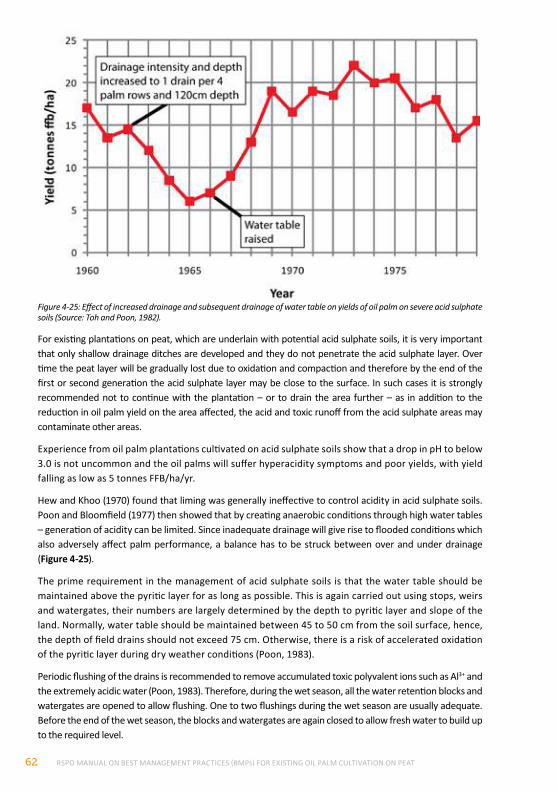
RSPO MANUAL ON BEST MANAGEMENT PRACTICES (BMPs) FOR EXISTING OIL PALM CULTIVATION ON PEAT62
For existing plantations on peat, which are underlain with potential acid sulphate soils, it is very important that only shallow drainage ditches are developed and they do not penetrate the acid sulphate layer. Over time the peat layer will be gradually lost due to oxidation and compaction and therefore by the end of the first or second generation the acid sulphate layer may be close to the surface. In such cases it is strongly recommended not to continue with the plantation – or to drain the area further – as in addition to the reduction in oil palm yield on the area affected, the acid and toxic runoff from the acid sulphate areas may contaminate other areas.
Experience from oil palm plantations cultivated on acid sulphate soils show that a drop in pH to below 3.0 is not uncommon and the oil palms will suffer hyperacidity symptoms and poor yields, with yield falling as low as 5 tonnes FFB/ha/yr.
Hew and Khoo (1970) found that liming was generally ineffective to control acidity in acid sulphate soils. Poon and Bloomfield (1977) then showed that by creating anaerobic conditions through high water tables – generation of acidity can be limited. Since inadequate drainage will give rise to flooded conditions which also adversely affect palm performance, a balance has to be struck between over and under drainage (Figure 4-25).
The prime requirement in the management of acid sulphate soils is that the water table should be maintained above the pyritic layer for as long as possible. This is again carried out using stops, weirs and watergates, their numbers are largely determined by the depth to pyritic layer and slope of the land. Normally, water table should be maintained between 45 to 50 cm from the soil surface, hence, the depth of field drains should not exceed 75 cm. Otherwise, there is a risk of accelerated oxidation of the pyritic layer during dry weather conditions (Poon, 1983).
Periodic flushing of the drains is recommended to remove accumulated toxic polyvalent ions such as Al3+ and the extremely acidic water (Poon, 1983). Therefore, during the wet season, all the water retention blocks and watergates are opened to allow flushing. One to two flushings during the wet season are usually adequate. Before the end of the wet season, the blocks and watergates are again closed to allow fresh water to build up to the required level.
Figure 4-25: Effect of increased drainage and subsequent drainage of water table on yields of oil palm on severe acid sulphate soils (Source: Toh and Poon, 1982).
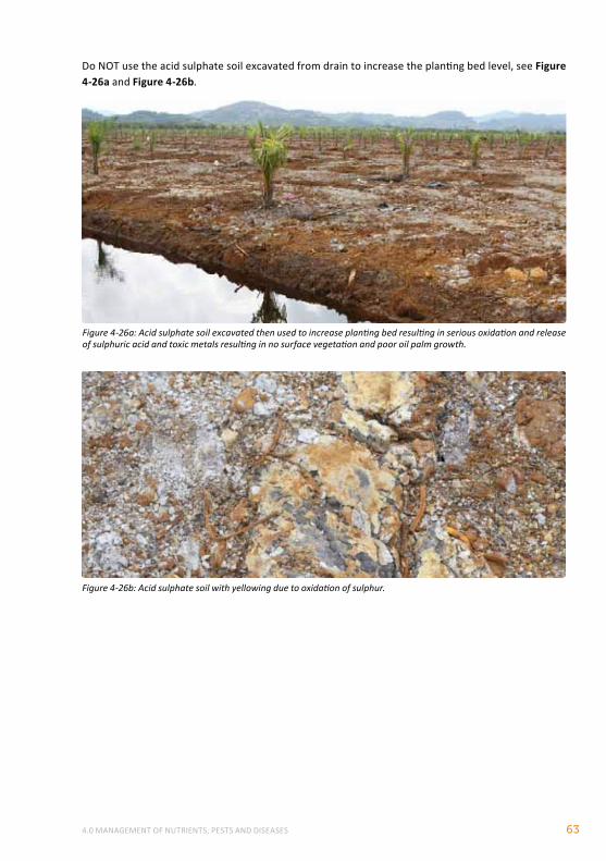
4.0 MANAGEMENT OF NUTRIENTS, PESTS AND DISEASES 63
Figure 4-26a: Acid sulphate soil excavated then used to increase planting bed resulting in serious oxidation and release of sulphuric acid and toxic metals resulting in no surface vegetation and poor oil palm growth.
Figure 4-26b: Acid sulphate soil with yellowing due to oxidation of sulphur.
Do NOT use the acid sulphate soil excavated from drain to increase the planting bed level, see Figure 4-26a and Figure 4-26b.
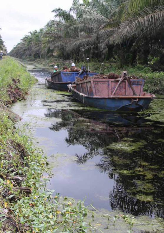
RSPO MANUAL ON BEST MANAGEMENT PRACTICES (BMPs) FOR EXISTING OIL PALM CULTIVATION ON PEAT64
5.0 BEST MANAGEMENT PRACTICES (BMPs) OPERATIONAL ISSUES 65
5.0 BEST MANAGEMENT PRACTICES (BMPs) OPERATIONAL ISSUES
This chapter provides practical guidance based on field experience and current knowledge on the following BMP topics: enhancing yield, transport systems (road, rail and water), labour and mechanization, training and field supervision.
5.1 enhAncIng YIeld
BoX 5Limiting factors of oil palm cultivation on peat soils and recommendations for yield enhancement (Pupathy and Chang, 2003)
BAckground InformAtIonGolden Hope Plantations Bhd (now Sime Darby Bhd), had initiated Lavang Oil Palm Plantations Project near Bintulu, Sarawak, in 1996, covering an area of about 11,900 hectares. Out of this, about 3,820 ha i.e. 32% of the total area was developed for oil palm planting on peat. A soil classification and suitability study in the Lavang Oil Palm Plantation Project revealed that about 67.6% of the area is dominated by mineral soils i.e. Merit and Bekenu series while the rest, approximately 32.4% of the area is classified as peat.
SoIl lImItIng fActorS:• pH – On shallow peat soils, a limiting factor is when the soil pH levels are below 3 (due to presence
of acid sulphate substratum). It has been shown that very acidic conditions could limit the general growth of palms, presumably due to the poor growth of root and its metabolic activity. Trials on liming had shown that lime treatments between 2 kg and 4 kg/palm/year had suppressed cropping to the 4th year of harvesting possibly due to Ca/K antagonism. Nevertheless the pH increased slowly and yield was better from the 7th year onwards in the limed plots. Care should be taken not to over apply lime as it can adversely affect the uptake of K and micro-nutrients.
Low yielding oil palm plantations on peat can be due to a number of reasons specific to each location. The main reasons for low yield are:
• Poor water management with over-drained areas
• Inadequate manuring
• Inadequate labour
• Poor field supervision and management
• Poor pest control especially termites, leaf-eating caterpillars and Tirathaba bunch moths
• Poor planting materials
• Vacant points or abnormal palm (best to supply/replace before age of 5 years)
If the limiting factors are poor planting material, low productive stand and high Ganoderma infection, it is best to carry out accelerated replanting.
“A Review of Practices in the Development of Oil Palms on Peat Soils” by Golden Hope (now Sime Darby) discusses the limiting factors on oil palm yield and provides updated information on rectifying the problems faced in developing oil palm cultivation on peat soils in Sarawak. Box 5 provides a summary of recommendations. Relevant guidance is also provided in the form of BMPs in Chapters 3.0 to 5.0.
RSPO MANUAL ON BEST MANAGEMENT PRACTICES (BMPs) FOR EXISTING OIL PALM CULTIVATION ON PEAT66
• Low micronutrient content – Peat soils are very deficient in micronutrients, especially copper (Cu) and zinc (Zn). Feeder roots play a big role in absorbing these nutrients from soils. However, absorption capacity of Cu and Zn elements are heavily fixed on complex organic compounds. Cu and Zn are usually applied at a range of 100 g to 200 g/palm/year during the first year of field planting. The optimum leaf Cu concentration in frond 17 is 5-8 ppm meanwhile the optimum leaf Zn concentration in frond 17 is 15-20 ppm. The critical leaf Cu and Zn content of frond 17 is 3 and 12 ppm respectively.
Correction of copper and zinc deficiencies is necessary to ensure better oil palm growth and yield on peat soils.
• Bulk density - Bulk density is the ratio of the mass to bulk or macroscopic volume of soil particles plus pore spaces in a sample. Bulk density is expressed in grams per cubic centimetre (g/cm3). Bulk density testing was carried out on peat soils after a compaction of 4 runs, 6 runs and 9 runs. Generally bulk density for all peat samples were very low, ranging from 0.10 to 0.15 g/cm3. Results also showed that the degree of bulk density increased with compaction. Yield on compacted plots was 30.57% higher than in non-compacted plots in the first year. However, the effect of compaction on yield declined over time. Actually the yield increase is manifested with increased bulk density due to compaction. An increased bulk density results in an increase of mass per unit volume of soil, which provides better contact with roots. Thus, palm performance was better as root proliferation and anchorage was increased with compaction.
pAlm lImItIng fActorS:• Palm leaning – Leaning of palms on peat is largely attributed to peat shrinkage and subsidence. The
situation is aggravated by the increasing weight of the palms as they grow older. There would be a two-year low cropping period with yield depression up to 30%, when palms suffering from leaning are trying to recover and growing upright again. Incidences of heavy leaning can be reduced through the use of right planting material and firmer anchorage of palm roots by increasing the bulk density of peat soils. It is reckoned that unidirectional leaning is tolerable for implementing mechanization on peat soils. Thus, attempts were made by the agronomists to achieve unidirectional leaning by means of forcing or planting at slanting position. Palm leaning could be a contributing factor in causing low harvester productivity. Leaning palms are subject to stress and tend to abort. In leaning palms, about half of the upper fronds are usually compressed as palms are in the progress of recovery for upright growth. Small size bunches were observed on leaning palms. In the other half portion of the palm, fronds tend to touch or come into contact with peat soil surface. Fronds in such positions could hinder the harvesting and loose fruit collection activities. The losses due to uncollected loose fruits are expected to be high.
• Palm canopy – Palm canopy on peat soils will be disturbed when palms are leaning, probably at the beginning of third year of field planting. Palms that suffer from leaning tend to have poor anchorage and end up leaning in different directions. Eventually, this situation will lead to inter-palm competition for light and nutrients and seriously hinder movements of harvester vehicles.
clImAtIc lImItIng fActorS:• Rainfall - The total annual rainfall in Sarawak ranges from 3,500-4,000 mm. Therefore, nutrient
losses due to leaching and surface runoff could be higher for peat soils that are porous in nature with poor nutrient retention capacity (especially for potassium, K). In view of this, higher dosage of K nutrient (up to 4 kg MOP/palm/year) was applied to the palms on peat in newly matured areas. Higher dosage of K application is required to maintain a proper K status in the palms and yield. The application of straight fertilizers (MOP and Urea) in perforated bags was a cost-effective and labour
5.0 BEST MANAGEMENT PRACTICES (BMPs) OPERATIONAL ISSUES 67
saving method for manuring your mature palms planted on deep peat soils. It is prudent, to consider such protective techniques to reduce fertilizer losses due to leaching and high rainfall in peat soils.
• Water management – During rainy seasons, a greater water flow is expected on peat soils and therefore a proper drainage system should be meticulously planned so that oil palm roots are not affected by reduced aeration in stagnant water. During periods of drought, water must be maintained to prevent irreversible drying of peat soils. Therefore, a water blocking system is required at strategic points along the collection drains to maintain the water level around 50 cm from the peat surface. It is also very important to maintain the optimum height of the water table to avoid any fire risk. There were past cases of flash floods due to back-flow of river water in Lavang Project. This is inevitable especially when peat soils are located in mostly low-lying and surrounding rivers. Selective bunding along the critical stretches of the riverbank is necessary to prevent back-flow of river water. Probably, frequent incidences of flash floods are also an indication that the mean water level of the river is above the mineral sub-soil level.
peSt And dISeASeS lImItIng fActorS:• Termite Infestation – Termite infestations are a major pest problem in oil palm plantings on peat.
Censuses in the Lavang project revealed that cases of new termite infestation are below 2.5% of total area while casualties are less than 1%. Out of the several termite species found on peat soils, only Coptotermes curvignathas (Rhinotermitidae: Coptotermitinae) is found to attack oil palms. This species would secrete a milky fluid when they are challenged or under attack. This species would initially reach the spear region by building mud tunnels and then bore into the living meristemic tissues. Therefore, presence of mud work on spear region is a good indication of termite attack. Early detection of termite infestations and prompt action in controlling termite infestations will reduce the cases of palm damaged/death due to termite infestation. Censuses of all palms on a monthly basis should be carried out to identify the number of infested palms in the fields. A point to- point plan of the termite-infested palms should be prepared and degree of infestation should be marked out in the plan. Areas with high termite infestation should be kept under close observation. Fipronil (Regent) is used at the rate of 2.5 ml per liters of water per palm as it has given longer lasting control.
• Ganoderma incidences – There is a strong relationship between major nutrients i.e. nitrogen, phosphorus and potassium and the basal stem rot of oil palm. Nitrogen (N) fertilizer significantly increased the incidences of Ganoderma and would pre-dispose oil palm to Ganoderma infection. Potassium (K) fertilizer significantly reduced the incidences of Ganoderma. As such, it may be possible to control the incidences of Ganoderma infection through fertilizer application management but more research needs to be done.
5.2 trAnSport SYStemSEffective transport systems are often referred to as the backbone of any oil palm plantation operation. The following are descriptions of and guidance pertaining to various options available for plantations on peatlands. Roads transport is still regarded as the most important option although this can be supplemented by other modes like water transportation. It is important to note that the focus of this Manual is on existing plantations, which will already have developed a transport system. However, some guidance is provided for the actual construction/establishment of various transport systems in the event that estates envision restructuring their transport systems during replanting periods.
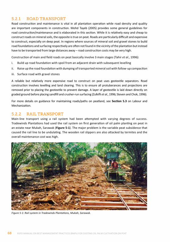
RSPO MANUAL ON BEST MANAGEMENT PRACTICES (BMPs) FOR EXISTING OIL PALM CULTIVATION ON PEAT68
5.2.1 roAd trAnSportRoad construction and maintenance is vital in all plantation operation while road density and quality are important components in construction. Mohd Tayeb (2005) provides some general guidelines for road construction/maintenance and is elaborated in this section. While it is relatively easy and cheap to construct roads on mineral soils, the opposite is true on peat. Roads are particularly difficult and expensive to construct, especially on deep peat. In regions where sources of mineral soil and gravel stones to build road foundations and surfacing respectively are often not found in the vicinity of the plantation but instead have to be transported from large distances away – road construction costs may be very high.
Construction of main and field roads on peat basically involve 3 main stages (Tahir et al., 1996):
i. Build up road foundation with spoil from an adjacent drain with subsequent levelling
ii. Raise up the road foundation with dumping of transported mineral soil with follow-up compaction
iii. Surface road with gravel stones
A reliable but relatively more expensive road to construct on peat uses geotextile separators. Road construction involves levelling and land clearing. This is to ensure all protuberances and projections are removed prior to placing the geotextile to prevent damage. A layer of geotextile is laid down directly on graded ground before placing sandfill and crusher-run surfacing (Zulkifli et al., 1996; Steven and Chok, 1996).
For more details on guidance for maintaining roads/paths on peatland, see Section 5.3 on Labour and Mechanization.
5.2.2 rAIl trAnSportMain-line transport using a rail system had been attempted with varying degrees of success. Tradewinds Plantations had used the rail system on first generation of oil palm planting on peat in an estate near Mukah, Sarawak (Figure 5-1). The major problem is the variable peat subsidence that caused the rail line to be undulating. The wooden rail slippers are also attacked by termites and the overall maintenance cost was high.
Figure 5-1: Rail system in Tradewinds Plantations, Mukah, Sarawak.
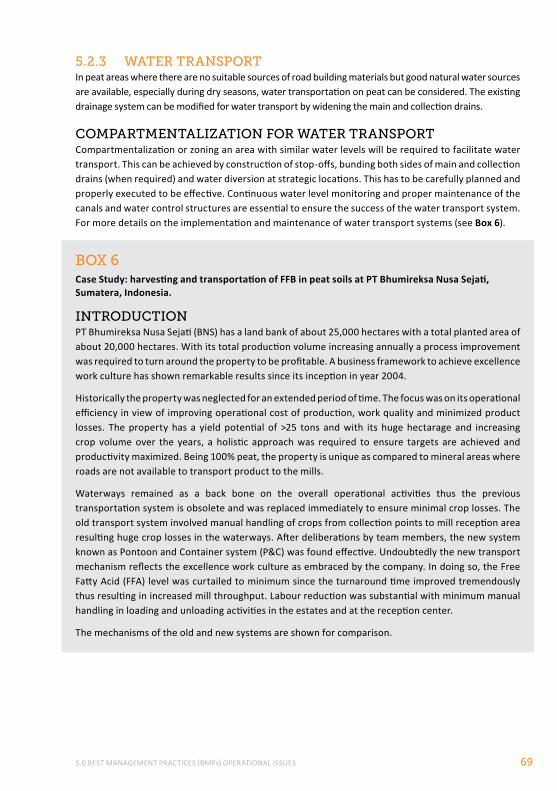
5.0 BEST MANAGEMENT PRACTICES (BMPs) OPERATIONAL ISSUES 69
BoX 6Case Study: harvesting and transportation of FFB in peat soils at PT Bhumireksa Nusa Sejati, Sumatera, Indonesia.
IntroductIonPT Bhumireksa Nusa Sejati (BNS) has a land bank of about 25,000 hectares with a total planted area of about 20,000 hectares. With its total production volume increasing annually a process improvement was required to turn around the property to be profitable. A business framework to achieve excellence work culture has shown remarkable results since its inception in year 2004.
Historically the property was neglected for an extended period of time. The focus was on its operational efficiency in view of improving operational cost of production, work quality and minimized product losses. The property has a yield potential of >25 tons and with its huge hectarage and increasing crop volume over the years, a holistic approach was required to ensure targets are achieved and productivity maximized. Being 100% peat, the property is unique as compared to mineral areas where roads are not available to transport product to the mills.
Waterways remained as a back bone on the overall operational activities thus the previous transportation system is obsolete and was replaced immediately to ensure minimal crop losses. The old transport system involved manual handling of crops from collection points to mill reception area resulting huge crop losses in the waterways. After deliberations by team members, the new system known as Pontoon and Container system (P&C) was found effective. Undoubtedly the new transport mechanism reflects the excellence work culture as embraced by the company. In doing so, the Free Fatty Acid (FFA) level was curtailed to minimum since the turnaround time improved tremendously thus resulting in increased mill throughput. Labour reduction was substantial with minimum manual handling in loading and unloading activities in the estates and at the reception center.
The mechanisms of the old and new systems are shown for comparison.
5.2.3 wAter trAnSportIn peat areas where there are no suitable sources of road building materials but good natural water sources are available, especially during dry seasons, water transportation on peat can be considered. The existing drainage system can be modified for water transport by widening the main and collection drains.
compArtmentAlIZAtIon for wAter trAnSportCompartmentalization or zoning an area with similar water levels will be required to facilitate water transport. This can be achieved by construction of stop-offs, bunding both sides of main and collection drains (when required) and water diversion at strategic locations. This has to be carefully planned and properly executed to be effective. Continuous water level monitoring and proper maintenance of the canals and water control structures are essential to ensure the success of the water transport system. For more details on the implementation and maintenance of water transport systems (see Box 6).
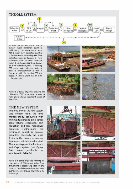
RSPO MANUAL ON BEST MANAGEMENT PRACTICES (BMPs) FOR EXISTING OIL PALM CULTIVATION ON PEAT70
Figure 5-3: Series of photos showing the old system of FFB transportation. Bottom right photo shows significant losses of loose fruits.
Figure 5-2: Schematic diagram showing the old FFB transportation system (from collection point to mill) using the contractor’s boat. KEY 1- From main collection point to collection point, 2- Loading FFB from collection point to bargas, 3- From collection point to main collection point, 4- Unloading FFB from bargas to main collection point, 5- Loading FFB from main collection point to boat, 6- Transportation to mill, 7- Queue at mill, 8- Loading FFB into cages, 9- Return from mill to main collection point.
the old SYStem
the new SYStemThe efficiency of the new system was evident from the time motion study conducted with minimal turnaround time, larger crop volume evacuated, cost reduction and less manpower required. Furthermore the significant impact is minimal crop loss especially the loose fruits in the canals as manual loading activities is ameliorated. The advantages of the Pontoons and Cages system (see Figure 5-4) were justifiable as stipulated in Table 5-1.
Figure 5-4: Series of photos showing the new system of FFB transportation. From top left: FFB in cages being lifted out of a pontoon, cage being moved and positioned over a boiler cage and FFB emptied into the boiler cage.
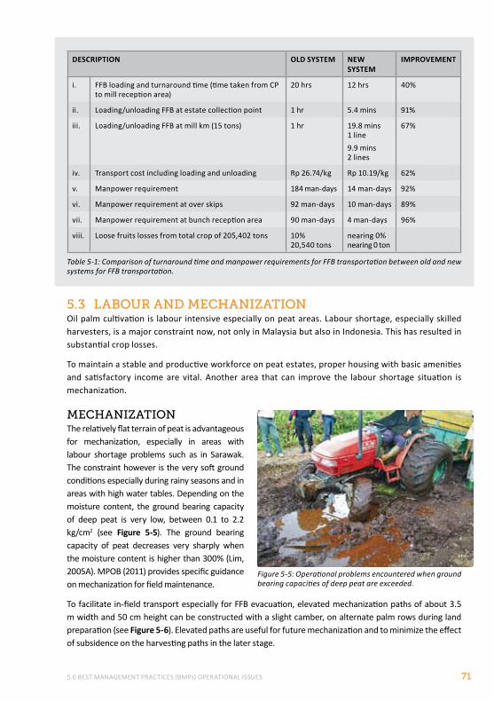
5.0 BEST MANAGEMENT PRACTICES (BMPs) OPERATIONAL ISSUES 71
DESCRIPTION OLD SySTEM NEW SySTEM
IMPROVEMENT
i. FFB loading and turnaround time (time taken from CP to mill reception area)
20 hrs 12 hrs 40%
ii. Loading/unloading FFB at estate collection point 1 hr 5.4 mins 91%
iii. Loading/unloading FFB at mill km (15 tons) 1 hr 19.8 mins 1 line9.9 mins 2 lines
67%
iv. Transport cost including loading and unloading Rp 26.74/kg Rp 10.19/kg 62%
v. Manpower requirement 184 man-days 14 man-days 92%
vi. Manpower requirement at over skips 92 man-days 10 man-days 89%
vii. Manpower requirement at bunch reception area 90 man-days 4 man-days 96%
viii. Loose fruits losses from total crop of 205,402 tons 10% 20,540 tons
nearing 0% nearing 0 ton
Table 5-1: Comparison of turnaround time and manpower requirements for FFB transportation between old and new systems for FFB transportation.
5.3 lABour And mechAnIZAtIonOil palm cultivation is labour intensive especially on peat areas. Labour shortage, especially skilled harvesters, is a major constraint now, not only in Malaysia but also in Indonesia. This has resulted in substantial crop losses.
To maintain a stable and productive workforce on peat estates, proper housing with basic amenities and satisfactory income are vital. Another area that can improve the labour shortage situation is mechanization.
mechAnIZAtIonThe relatively flat terrain of peat is advantageous for mechanization, especially in areas with labour shortage problems such as in Sarawak. The constraint however is the very soft ground conditions especially during rainy seasons and in areas with high water tables. Depending on the moisture content, the ground bearing capacity of deep peat is very low, between 0.1 to 2.2 kg/cm2 (see Figure 5-5). The ground bearing capacity of peat decreases very sharply when the moisture content is higher than 300% (Lim, 2005A). MPOB (2011) provides specific guidance on mechanization for field maintenance.
To facilitate in-field transport especially for FFB evacuation, elevated mechanization paths of about 3.5 m width and 50 cm height can be constructed with a slight camber, on alternate palm rows during land preparation (see Figure 5-6). Elevated paths are useful for future mechanization and to minimize the effect of subsidence on the harvesting paths in the later stage.
Figure 5-5: Operational problems encountered when ground bearing capacities of deep peat are exceeded.
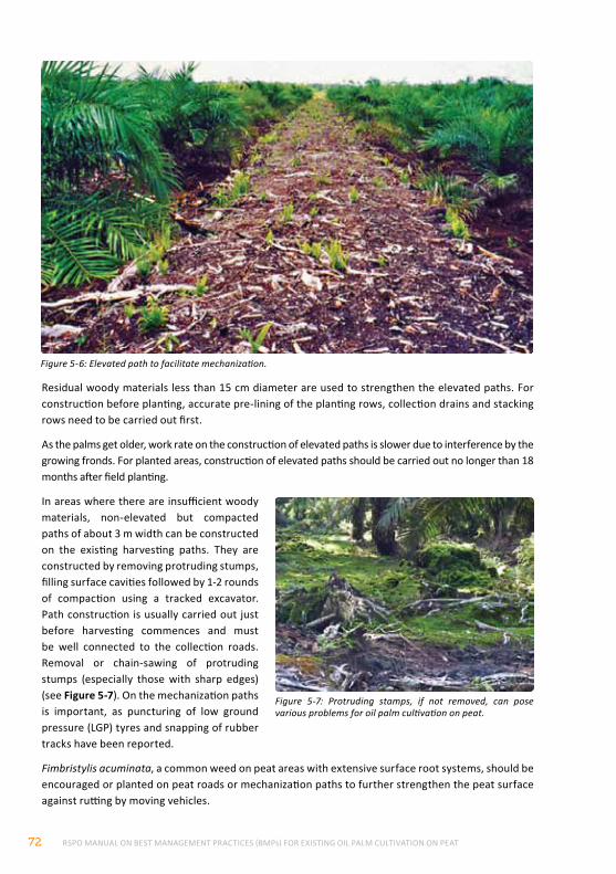
RSPO MANUAL ON BEST MANAGEMENT PRACTICES (BMPs) FOR EXISTING OIL PALM CULTIVATION ON PEAT72
Residual woody materials less than 15 cm diameter are used to strengthen the elevated paths. For construction before planting, accurate pre-lining of the planting rows, collection drains and stacking rows need to be carried out first.
As the palms get older, work rate on the construction of elevated paths is slower due to interference by the growing fronds. For planted areas, construction of elevated paths should be carried out no longer than 18 months after field planting.
In areas where there are insufficient woody materials, non-elevated but compacted paths of about 3 m width can be constructed on the existing harvesting paths. They are constructed by removing protruding stumps, filling surface cavities followed by 1-2 rounds of compaction using a tracked excavator. Path construction is usually carried out just before harvesting commences and must be well connected to the collection roads. Removal or chain-sawing of protruding stumps (especially those with sharp edges) (see Figure 5-7). On the mechanization paths is important, as puncturing of low ground pressure (LGP) tyres and snapping of rubber tracks have been reported.
Fimbristylis acuminata, a common weed on peat areas with extensive surface root systems, should be encouraged or planted on peat roads or mechanization paths to further strengthen the peat surface against rutting by moving vehicles.
Figure 5-6: Elevated path to facilitate mechanization.
Figure 5-7: Protruding stamps, if not removed, can pose various problems for oil palm cultivation on peat.
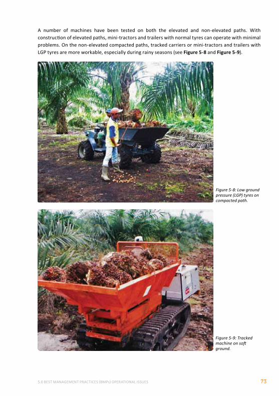
5.0 BEST MANAGEMENT PRACTICES (BMPs) OPERATIONAL ISSUES 73
A number of machines have been tested on both the elevated and non-elevated paths. With construction of elevated paths, mini-tractors and trailers with normal tyres can operate with minimal problems. On the non-elevated compacted paths, tracked carriers or mini-tractors and trailers with LGP tyres are more workable, especially during rainy seasons (see Figure 5-8 and Figure 5-9).
Figure 5-8: Low ground pressure (LGP) tyres on compacted path.
Figure 5-9: Tracked machine on soft ground.
RSPO MANUAL ON BEST MANAGEMENT PRACTICES (BMPs) FOR EXISTING OIL PALM CULTIVATION ON PEAT74
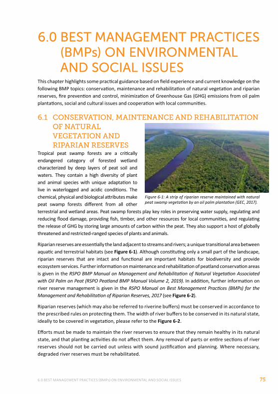
6.0 BEST MANAGEMENT PRACTICES (BMPs) ON ENVIRONMENTAL AND SOCIAL ISSUES 75
6.0 BEST MANAGEMENT PRACTICES (BMPs) ON ENVIRONMENTAL ANd SOCIAL ISSUES
This chapter highlights some practical guidance based on field experience and current knowledge on the following BMP topics: conservation, maintenance and rehabilitation of natural vegetation and riparian reserves, fire prevention and control, minimization of Greenhouse Gas (GHG) emissions from oil palm plantations, social and cultural issues and cooperation with local communities.
6.1 conServAtIon, mAIntenAnce And rehABIlItAtIon of nAturAl vegetAtIon And rIpArIAn reServeS
Tropical peat swamp forests are a critically endangered category of forested wetland characterized by deep layers of peat soil and waters. They contain a high diversity of plant and animal species with unique adaptation to live in waterlogged and acidic conditions. The chemical, physical and biological attributes make peat swamp forests different from all other terrestrial and wetland areas. Peat swamp forests play key roles in preserving water supply, regulating and reducing flood damage, providing fish, timber, and other resources for local communities, and regulating the release of GHG by storing large amounts of carbon within the peat. They also support a host of globally threatened and restricted-ranged species of plants and animals.
Riparian reserves are essentially the land adjacent to streams and rivers; a unique transitional area between aquatic and terrestrial habitats (see Figure 6-1). Although constituting only a small part of the landscape, riparian reserves that are intact and functional are important habitats for biodiversity and provide ecosystem services. Further information on maintenance and rehabilitation of peatland conservation areas is given in the RSPO BMP Manual on Management and Rehabilitation of Natural Vegetation Associated with Oil Palm on Peat (RSPO Peatland BMP Manual Volume 2, 2019). In addition, further information on river reserve management is given in the RSPO Manual on Best Management Practices (BMPs) for the Management and Rehabilitation of Riparian Reserves, 2017 (see Figure 6-2).
Riparian reserves (which may also be referred to riverine buffers) must be conserved in accordance to the prescribed rules on protecting them. The width of river buffers to be conserved in its natural state, ideally to be covered in vegetation, please refer to the Figure 6-2.
Efforts must be made to maintain the river reserves to ensure that they remain healthy in its natural state, and that planting activities do not affect them. Any removal of parts or entire sections of river reserves should not be carried out unless with sound justification and planning. Where necessary, degraded river reserves must be rehabilitated.
Figure 6-1: A strip of riparian reserve maintained with natural peat swamp vegetation by an oil palm plantation (GEC, 2017).
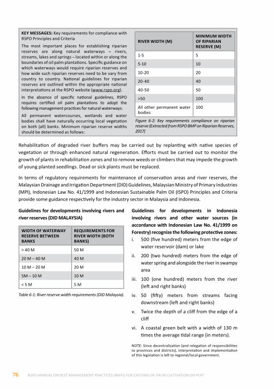
RSPO MANUAL ON BEST MANAGEMENT PRACTICES (BMPs) FOR EXISTING OIL PALM CULTIVATION ON PEAT76
Rehabilitation of degraded river buffers may be carried out by replanting with native species of vegetation or through enhanced natural regeneration. Efforts must be carried out to monitor the growth of plants in rehabilitation zones and to remove weeds or climbers that may impede the growth of young planted seedlings. Dead or sick plants must be replaced.
In terms of regulatory requirements for maintenance of conservation areas and river reserves, the Malaysian Drainage and Irrigation Department (DID) Guidelines, Malaysian Ministry of Primary Industries (MPI), Indonesian Law No. 41/1999 and Indonesian Sustainable Palm Oil (ISPO) Principles and Criteria provide some guidance respectively for the industry sector in Malaysia and Indonesia.
Table 6-1: River reserve width requirements (DID Malaysia).
Guidelines for developments involving rivers and river reserves (DID MALAYSIA)
WIDTH OF WATERWAy RESERVE BETWEEN BANKS
REQUIREMENTS FOR RIVER WIDTH (BOTH BANKS)
> 40 M 50 M
20 M – 40 M 40 M
10 M – 20 M 20 M
5M – 10 M 10 M
< 5 M 5 M
Guidelines for developments in Indonesia involving rivers and other water sources (in accordance with Indonesian Law No. 41/1999 on Forestry) recognize the following protective zones:i. 500 (five hundred) meters from the edge of
water reservoir (dam) or lake
ii. 200 (two hundred) meters from the edge of water spring and alongside the river in swampy area
iii. 100 (one hundred) meters from the river (left and right banks)
iv. 50 (fifty) meters from streams facing downstream (left and right banks)
v. Twice the depth of a cliff from the edge of a cliff
vi. A coastal green belt with a width of 130 m times the average tidal range (in meters).
NOTE: Since decentralization (and relegation of responsibilities to provinces and districts), interpretation and implementation of this legislation is left to regional/local government.
KEy MESSAGES: Key requirements for compliance with RSPO Principles and Criteria
The most important places for establishing riparian reserves are along natural waterways – rivers, streams, lakes and springs – located within or along the boundaries of oil palm plantations. Specific guidance on which waterways would require riparian reserves and how wide such riparian reserves need to be vary from country to country. National guidelines for riparian reserves are outlined within the appropriate national interpretations at the RSPO website (www.rspo.org).
In the absence of specific national guidelines, RSPO requires certified oil palm plantations to adopt the following management practices for natural waterways:
All permanent watercourses, wetlands and water bodies shall have naturally occurring local vegetation on both (all) banks. Minimum riparian reserve widths should be determined as follows:
Figure 6-2: Key requirements compliance on riparian reserve (Extracted from RSPO BMP on Riparian Reserves, 2017)
RIVER WIDTH (M)MINIMUM WIDTH OF RIPARIAN RESERVE (M)
1-5 5
5-10 10
10-20 20
20-40 40
40-50 50
>50 100
All other permanent water bodies
100
6.0 BEST MANAGEMENT PRACTICES (BMPs) ON ENVIRONMENTAL AND SOCIAL ISSUES 77
BoX 7
guIdAnce noteS on lAndScApe ApproAchThe landscape approach to conservation emphasizes on making decisions at a landscape scale. There are many definitions. Citing Sayer et al., (2013):
“Landscape approaches seek to provide tools and concepts for allocating and managing land to achieve social, economic, and environmental objectives in areas where agriculture, mining, and other productive land uses compete with environmental and biodiversity goals.”
It also helps reach decisions about the advisability of particular interventions (such as a new road or plantation) and to facilitate the planning, negotiation and implementation of activities across a whole landscape. This approach has been widely advocated to help address pressures on resources (land, water, etc.) utilisation and to accommodate future needs. The boundary of landscape approach transcends across traditional management boundaries, that include environmental, economic, social and political challenges, including temporal consideration.
The landscape approach is a dynamic process. The 10 key principles of landscape approach, based on Sayer et al., (2013) are:
Oil palm plantations have a role in identifying, managing and enhancing riparian reserves and peat swamp forests that are on and adjacent to their land. Preferably, these areas should be identified during initial stages of plantation development and this can be incorporated into the HCV maps. These areas need to be conserved/ managed and where necessary, rehabilitated. This activity during the initial stages is crucial to avoid extensive costs to rehabilitate cleared or planted (oil palm) riparian reserves and other areas unsuitable for oil palm or have HCV in the long run. For plantations that have already planted oil palms on river reserves, steps must be taken to restore these areas.
The following are examples of areas that are recommended to be identified, managed and enhanced as conservations areas within plantations on peatlands due to their HCV and/or unsuitability for planting oil palms:
• Peat dome (Padang Raya) areas (low moisture and fertility)
• Shoulder of dome (Alan Forest) areas (large roots contained in peat)
• Undrainable areas such as vital wildlife corridors (to avoid human-wildlife conflict)
• Remaining natural peat swamp forest areas and streams with endemic or endangered species or other HCV characteristics
Box 7 below provides some guidance on landscape approaches:
Principle 1: Continual learning and adaptive management
Principle 2: Common concern entry point
Principle 3: Multiple scale
Principle 4: Multi-functionality
Principle 5: Multiple stakeholder
Principle 6: Negotiated and transparent change logic
Principle 7: Clarification of rights and responsibilities
Principle 8: Participatory and user-friendly monitoring
Principle 9: Resilience
Principle 10: Strengthened stakeholder capacity
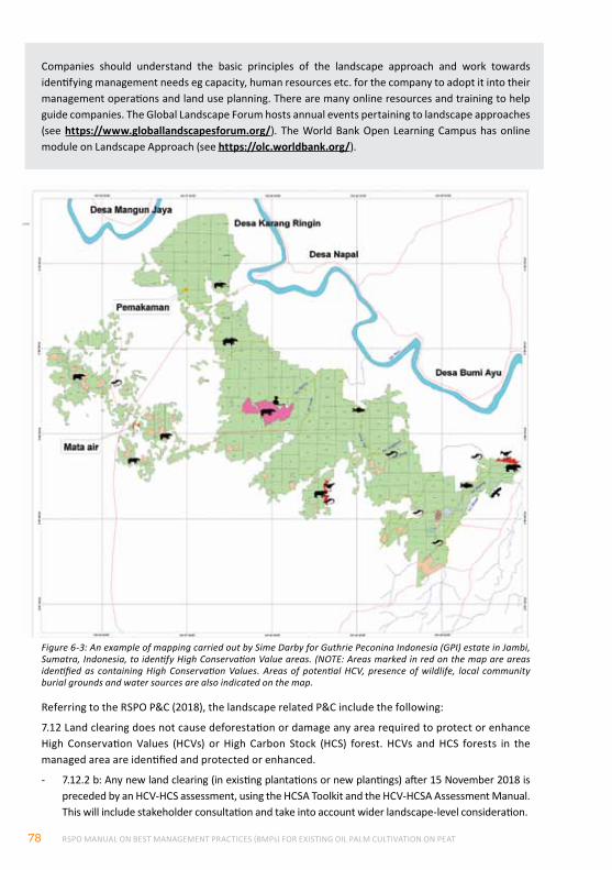
RSPO MANUAL ON BEST MANAGEMENT PRACTICES (BMPs) FOR EXISTING OIL PALM CULTIVATION ON PEAT78
Figure 6-3: An example of mapping carried out by Sime Darby for Guthrie Peconina Indonesia (GPI) estate in Jambi, Sumatra, Indonesia, to identify High Conservation Value areas. (NOTE: Areas marked in red on the map are areas identified as containing High Conservation Values. Areas of potential HCV, presence of wildlife, local community burial grounds and water sources are also indicated on the map.
Companies should understand the basic principles of the landscape approach and work towards identifying management needs eg capacity, human resources etc. for the company to adopt it into their management operations and land use planning. There are many online resources and training to help guide companies. The Global Landscape Forum hosts annual events pertaining to landscape approaches (see https://www.globallandscapesforum.org/). The World Bank Open Learning Campus has online module on Landscape Approach (see https://olc.worldbank.org/).
Referring to the RSPO P&C (2018), the landscape related P&C include the following:
7.12 Land clearing does not cause deforestation or damage any area required to protect or enhance High Conservation Values (HCVs) or High Carbon Stock (HCS) forest. HCVs and HCS forests in the managed area are identified and protected or enhanced.
- 7.12.2 b: Any new land clearing (in existing plantations or new plantings) after 15 November 2018 is preceded by an HCV-HCS assessment, using the HCSA Toolkit and the HCV-HCSA Assessment Manual. This will include stakeholder consultation and take into account wider landscape-level consideration.
6.0 BEST MANAGEMENT PRACTICES (BMPs) ON ENVIRONMENTAL AND SOCIAL ISSUES 79
ISPO CRITERION 3.7 Conservation area with high potential for erosion – Oil palm planters and millers should conserve the land and avoid erosion according to rules and regulations.
ISPO CRITERION 3.8 Plantation in accordance with Presidential Decree No. 10/2011 – Postponement on oil palm plantation development to decrease greenhouse gas (GHG) emissions through moratorium on new permits and improvements to the management of primary natural forests and peatlands.
• INDICATORSi. Moratorium on new permit included in indicative maps;
ii. Approved application by authorized institution on land permit is valid;
iii. Existing permits issued before the moratorium remain in effect.
- 7.12.3 (C): In High Forest Cover Landscapes (HFCLs) within High Forest Cover Countries (HFCCs), a specific procedure will apply for legacy cases and development by indigenous peoples and local communities with legal or customary rights, taking into consideration regional and national multi-stakeholder processes. Until this procedure is developed and endorsed, 7.12.2 applies.
- 7.12.4 (C): Where HCVs, HCS forests after 15 November 2018, peatland and other conservation areas have been identified, they are protected and/or enhanced. An integrated management plan to protect and/or enhance HCVs, HCS forests, peatland and other conservation areas is developed, implemented and adapted where necessary, and contains monitoring requirements. The integrated management plan is reviewed at least once every five years. The integrated management plan is developed in consultation with relevant stakeholders and includes the directly managed area and any relevant wider landscape level considerations (where these are identified).
According to the High Conservation Value Resource Network (HCVRN) Common Guidance for Identification of HCVs 2017, it spells as follows:
- HCV 2 – Landscape-level ecosystems, ecosystem mosaics and Intact Forest Landscapes (IFL): Large landscape-level ecosystems, ecosystem mosaics and IFL that are significant at global, regional or national levels, and that contain viable populations of the great majority of the naturally occurring species in natural patterns of distribution and abundance.
Figure 6-3 is an example of actual mapping carried out by Sime Darby for Guthrie Peconina Indonesia (GPI) estate in Jambi, Sumatra, Indonesia, to identify HCV areas for their estates.
IndoneSIAn SuStAInABle pAlm oIl (ISpo) prIncIpleS And crIterIAISPO CRITERION 3.5 Identification and protection of protected areas – Oil palm planters and millers should identify protected areas, which have the prime function to protect biodiversity, including natural and manmade resources as well as historical and culturally valuable areas. These areas should not to be planted with oil palm.
• INDICATORSi. Identified protected area is available
ii. Plantation map showing identified protected area is available
iii. Records of identification and distribution information of protected areas are kept
• GUIDANCEi. To do inventory on protected areas around
the plantation
ii. Distribution of protected forest information to workers and surrounding community/farmers around the plantation
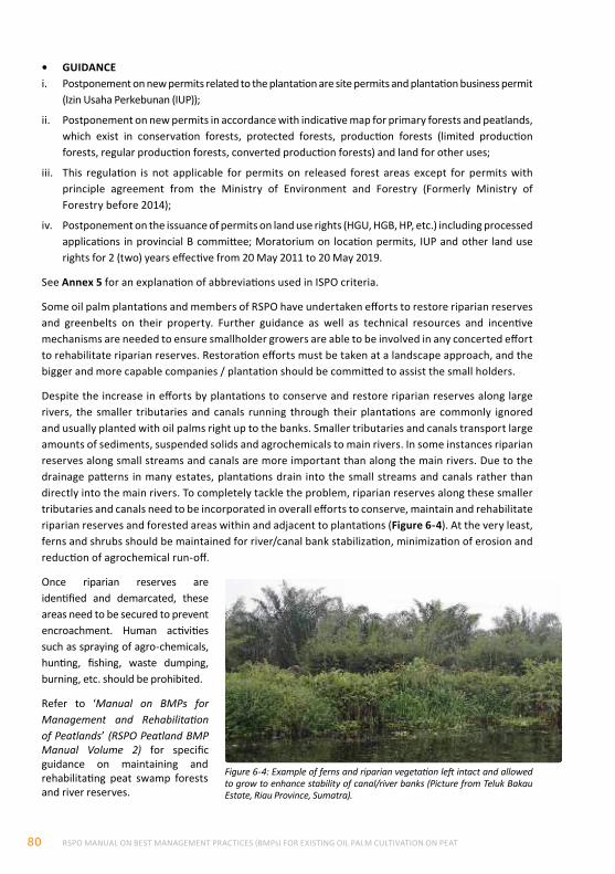
RSPO MANUAL ON BEST MANAGEMENT PRACTICES (BMPs) FOR EXISTING OIL PALM CULTIVATION ON PEAT80
• GUIDANCEi. Postponement on new permits related to the plantation are site permits and plantation business permit
(Izin Usaha Perkebunan (IUP));
ii. Postponement on new permits in accordance with indicative map for primary forests and peatlands, which exist in conservation forests, protected forests, production forests (limited production forests, regular production forests, converted production forests) and land for other uses;
iii. This regulation is not applicable for permits on released forest areas except for permits with principle agreement from the Ministry of Environment and Forestry (Formerly Ministry of Forestry before 2014);
iv. Postponement on the issuance of permits on land use rights (HGU, HGB, HP, etc.) including processed applications in provincial B committee; Moratorium on location permits, IUP and other land use rights for 2 (two) years effective from 20 May 2011 to 20 May 2019.
See Annex 5 for an explanation of abbreviations used in ISPO criteria.
Some oil palm plantations and members of RSPO have undertaken efforts to restore riparian reserves and greenbelts on their property. Further guidance as well as technical resources and incentive mechanisms are needed to ensure smallholder growers are able to be involved in any concerted effort to rehabilitate riparian reserves. Restoration efforts must be taken at a landscape approach, and the bigger and more capable companies / plantation should be committed to assist the small holders.
Despite the increase in efforts by plantations to conserve and restore riparian reserves along large rivers, the smaller tributaries and canals running through their plantations are commonly ignored and usually planted with oil palms right up to the banks. Smaller tributaries and canals transport large amounts of sediments, suspended solids and agrochemicals to main rivers. In some instances riparian reserves along small streams and canals are more important than along the main rivers. Due to the drainage patterns in many estates, plantations drain into the small streams and canals rather than directly into the main rivers. To completely tackle the problem, riparian reserves along these smaller tributaries and canals need to be incorporated in overall efforts to conserve, maintain and rehabilitate riparian reserves and forested areas within and adjacent to plantations (Figure 6-4). At the very least, ferns and shrubs should be maintained for river/canal bank stabilization, minimization of erosion and reduction of agrochemical run-off.
Once riparian reserves are identified and demarcated, these areas need to be secured to prevent encroachment. Human activities such as spraying of agro-chemicals, hunting, fishing, waste dumping, burning, etc. should be prohibited.
Refer to ‘Manual on BMPs for Management and Rehabilitation of Peatlands’ (RSPO Peatland BMP Manual Volume 2) for specific guidance on maintaining and rehabilitating peat swamp forests and river reserves.
Figure 6-4: Example of ferns and riparian vegetation left intact and allowed to grow to enhance stability of canal/river banks (Picture from Teluk Bakau Estate, Riau Province, Sumatra).
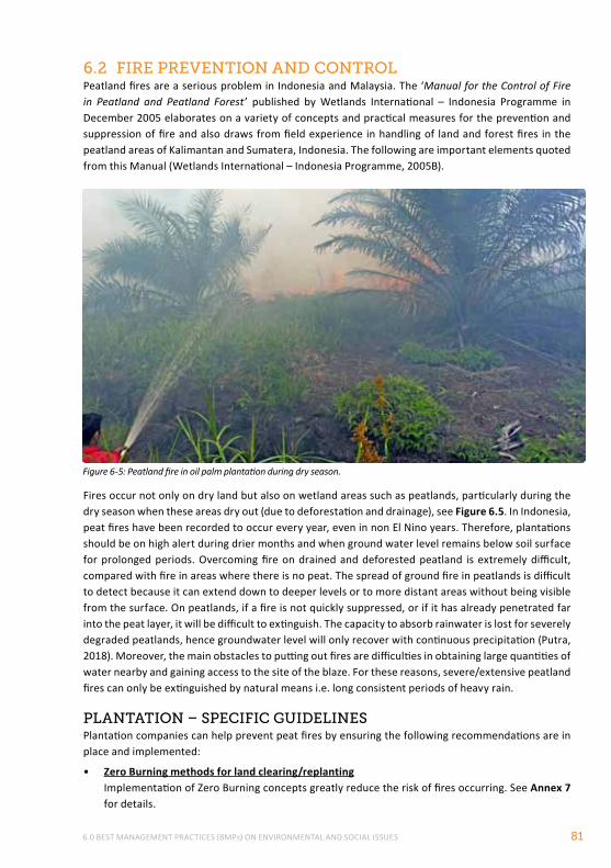
6.0 BEST MANAGEMENT PRACTICES (BMPs) ON ENVIRONMENTAL AND SOCIAL ISSUES 81
6.2 fIre preventIon And controlPeatland fires are a serious problem in Indonesia and Malaysia. The ‘Manual for the Control of Fire in Peatland and Peatland Forest’ published by Wetlands International – Indonesia Programme in December 2005 elaborates on a variety of concepts and practical measures for the prevention and suppression of fire and also draws from field experience in handling of land and forest fires in the peatland areas of Kalimantan and Sumatera, Indonesia. The following are important elements quoted from this Manual (Wetlands International – Indonesia Programme, 2005B).
Fires occur not only on dry land but also on wetland areas such as peatlands, particularly during the dry season when these areas dry out (due to deforestation and drainage), see Figure 6.5. In Indonesia, peat fires have been recorded to occur every year, even in non El Nino years. Therefore, plantations should be on high alert during drier months and when ground water level remains below soil surface for prolonged periods. Overcoming fire on drained and deforested peatland is extremely difficult, compared with fire in areas where there is no peat. The spread of ground fire in peatlands is difficult to detect because it can extend down to deeper levels or to more distant areas without being visible from the surface. On peatlands, if a fire is not quickly suppressed, or if it has already penetrated far into the peat layer, it will be difficult to extinguish. The capacity to absorb rainwater is lost for severely degraded peatlands, hence groundwater level will only recover with continuous precipitation (Putra, 2018). Moreover, the main obstacles to putting out fires are difficulties in obtaining large quantities of water nearby and gaining access to the site of the blaze. For these reasons, severe/extensive peatland fires can only be extinguished by natural means i.e. long consistent periods of heavy rain.
plAntAtIon – SpecIfIc guIdelIneSPlantation companies can help prevent peat fires by ensuring the following recommendations are in place and implemented:
• Zero Burning methods for land clearing/replantingImplementation of Zero Burning concepts greatly reduce the risk of fires occurring. See Annex 7 for details.
Figure 6-5: Peatland fire in oil palm plantation during dry season.
RSPO MANUAL ON BEST MANAGEMENT PRACTICES (BMPs) FOR EXISTING OIL PALM CULTIVATION ON PEAT82
• Effective surveillance and monitoringIn order for surveillance and monitoring of plantation activities to be effective, overall work needs to be broken down into smaller management units i.e. unit, block, and sub-block. The leader of each unit, block and sub-block is responsible for the surveillance and monitoring of their area with regards to fire prevention. There should also be an intensive network of paths around estate blocks to facilitate surveillance and enable fire-fighting personnel and equipment to access areas of concern quickly. These paths can also function as fire breaks to prevent surface fires from spreading.
EXAMPLE: In Sarawak, the authority makes it the responsibility of land owners in sensitive peatland areas to jointly monitor fire risks, through a Memorandum of Understanding signed between them. A set of Standard Operating Procedure has been developed, which among others, requires landowners to observe three trigger points: (i) prolonged no rain days; (ii) increase in air pollution index; and (iii) increase in fire weather index. Plantation owners may jointly implement a collective approach in watching out for signs of fire danger in peatland adjacent to their plantations, and develop a fast communication and response protocol (www.nreb.gov.my).
• Maintenance of ground water levelKeeping ground water level high and peat soil moist minimises the risk of incidental fire. For details, see Chapter 3 on Water Management
• Formation of land and peat forest fire suppression unitsIt is important to develop an organizational structure to handle fire control in a plantation company. Overall leadership should be provided by the Head of the Fire Protection Division and this person has the overall responsibility for managing fires in the plantation and coordinating fire suppression activities. The following personnel should be in place to support the Head of Fire Protection Division:
• Information Unit: develops and manages information related to fire danger
• Special Fire-Fighting Unit: backs up the core fire-fighting units
• Guard/Logistics Unit: mobilizes equipment and handles logistics
• Sentry units: posted in places that are especially prone to fire
• Core fire-fighting units (for each block): patrol units who have the task of surveillance over the whole block
• Community Liaison Unit: Serves as a liaison with neighbouring communities to prevent and combat fire. For example, the IOI Group operating in Kalimantan have been constantly engaging with the surrounding communities to help monitor land use change and cultivation activities. Monitoring is done to ensure that there is no fire being used for land clearing. In order to deter the use of fire, the company has provided chemical knapsacks and hand tractors to selected farmers to reduce the need for land clearing by fire.
For more details on fire prevention and suppression including specific guidance on techniques for suppression of land and forest fire in peatland areas as well as zero burning techniques, see Annex 6.
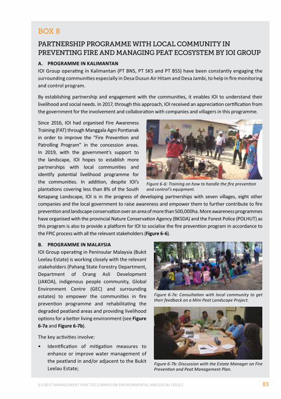
6.0 BEST MANAGEMENT PRACTICES (BMPs) ON ENVIRONMENTAL AND SOCIAL ISSUES 83
BoX 8
pArtnerShIp progrAmme wIth locAl communItY In preventIng fIre And mAnAgIng peAt ecoSYStem BY IoI group
A. PROGRAMME IN KALIMANTANIOI Group operating in Kalimantan (PT BNS, PT SKS and PT BSS) have been constantly engaging the surrounding communities especially in Desa Dusun Air Hitam and Desa Jambi, to help in fire monitoring and control program.
By establishing partnership and engagement with the communities, it enables IOI to understand their livelihood and social needs. In 2017, through this approach, IOI received an appreciation certification from the government for the involvement and collaboration with companies and villagers in this programme.
Since 2016, IOI had organised Fire Awareness Training (FAT) through Manggala Agni Pontianak in order to improve the “Fire Prevention and Patrolling Program” in the concession areas. In 2019, with the government’s support to the landscape, IOI hopes to establish more partnerships with local communities and identify potential livelihood programme for the communities. In addition, despite IOI’s plantations covering less than 8% of the South Ketapang Landscape, IOI is in the progress of developing partnerships with seven villages, eight other companies and the local government to raise awareness and empower them to further contribute to fire prevention and landscape conservation over an area of more than 500,000ha. More awareness programmes have organised with the provincial Nature Conservation Agency (BKSDA) and the Forest Police (POLHUT) as this program is also to provide a platform for IOI to socialise the fire prevention program in accordance to the FPIC process with all the relevant stakeholders (Figure 6-6).
B. PROGRAMME IN MALAYSIAIOI Group operating in Peninsular Malaysia (Bukit Leelau Estate) is working closely with the relevant stakeholders (Pahang State Forestry Department, Department of Orang Asli Development (JAKOA), indigenous people community, Global Environment Centre (GEC) and surrounding estates) to empower the communities in fire prevention programme and rehabilitating the degraded peatland areas and providing livelihood options for a better living environment (see Figure 6-7a and Figure 6-7b).
The key activities involve:
• Identification of mitigation measures to enhance or improve water management of the peatland in and/or adjacent to the Bukit Leelau Estate;
Figure 6-6: Training on how to handle the fire prevention and control’s equipment.
Figure 6-7a: Consultation with local community to get their feedback on a Mini Peat Landscape Project.
Figure 6-7b: Discussion with the Estate Manager on Fire Prevention and Peat Management Plan.
RSPO MANUAL ON BEST MANAGEMENT PRACTICES (BMPs) FOR EXISTING OIL PALM CULTIVATION ON PEAT84
6.3 mInImIZAtIon of greenhouSe gAS (ghg) emISSIonS from oIl pAlm plAntAtIonS
A commitment toward improving sustainability and reducing GHG emissions has continued to expand across the palm oil industry. A large range of new and improved management practices that result in emission reductions are emerging and being adopted by many companies. The RSPO has developed a tool (Palm GHG) to monitor and report GHG emissions resulting from the plantation and mill (see Box 9).
The transformation of an intact peat swamp area to oil palm plantation leads to a release of carbon and GHG to the atmosphere (Matysek et al., 2018; De Vries et al., 2010; Hooijer et al., 2010; Henson, 2009; Jeanicke et al., 2008; Danielson et al., 2008; Fargione et al., 2008; Rieley et al., 2008; Gibbs et al., 2008; Wosten and Ritzema, 2001). When oil palm plantations are developed on peat, oxidation due to drainage, the possible increased fire frequency and carbon losses in the case that forest is cleared are the major sources of significant increases in GHG emissions. Page et al., (2011) reviewed a large number of assessments of GHG emissions from peatlands in Southeast Asia and concluded that the best available estimate of GHG emissions from oil palm plantations on peat was 86 tonnes of CO2 per ha per year (annualized over 50 years) based on combined subsidence measurements and closed chamber measurements in the same plantation landscape.
Methane emissions from open water bodies such as drainage canals and ponds are likely to impact the methane balance (Manning et al., 2017). This may be significant since the water surface from the drainage canals may account for up to 5% of the total area of a plantation on peatland. Nitrous oxide is primarily emitted from agricultural landscapes as a by-product of nitrification and denitrification. In oil palm plantations, the application of fertilizers in particular accelerates the release of nitrous oxide and also of CO2 (by catalysing biological processes that result in oxidation). Current sustainability measures in oil palm plantations on peatlands will only decrease emission source strengths, but will not stop peat carbon emissions, which with a drainage level of 40-50 cm will still be around 35-45 ton of CO2 per ha per year (following the calculation in the RSPO Palm GHG Calculator)
Once a plantation is developed, maintaining the water table as high as practically possible (40-50 cm) and preventing fires will considerably reduce CO2 emissions since oxidation and fires are the largest emission sources.
• Provide training programme for local community through suitable empowerment and engagement programme with local community (i.e. indigenous people / Orang Asli)
• Support establishment of community nursery(ies) of peat swamp forest species for peatland rehabilitation; and
• Engagement with relevant stakeholders (state and district governments, neighbouring plantations, local communities, etc.) to support the peat landscape management for long term sustainability of the programme.
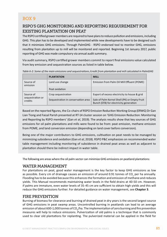
6.0 BEST MANAGEMENT PRACTICES (BMPs) ON ENVIRONMENTAL AND SOCIAL ISSUES 85
BoX 9
rSpo’S ghg monItorIng And reportIng reQuIrement for eXIStIng plAntAtIon on peAtThe RSPO certified grower members are required to have plans to reduce pollution and emissions, including GHG. This plan has to be developed and implemented while new developments have to be designed such that it minimizes GHG emissions. Through PalmGHG - RSPO endorsed tool to monitor GHG, emissions resulting from plantation up to mill will be monitored and reported. Beginning 1st January 2017, public reporting of GHG was made compulsory via annual audit summary.
Via audit summary, RSPO certified grower members commit to report final emissions value calculated from key emission and sequestration sources as listed in table below.
Table 6-2: Some of the main emissions and sequestrations /credit from plantation and mill calculated in PalmGHG
PLANTATION MILL
Source of emission
Land use change Emission from Palm Oil Mill Effluent (POME)
Peat oxidation
Source of sequestration or credits
Crop sequestration Export of excess electricity to house & grid
Sequestration in conservation area Sale of Palm Kernel Shell (PK) or Empty Fruit Bunch (EFB) for electricity generation
Based on the reported figures, the Co-chairs of RSPO Emission Reduction Working Group (ERWG) Dr Gan Lian Tiong and Faizal Parish presented at RT-14 cluster session on ‘GHG Emission Reduction: Monitoring and Reporting by RSPO members’ (Gan et al, 2019). The analysis results show that key sources of GHG emissions for oil palm plantations and mills were found to be from: peat emission, methane emission from POME, and land conversion emission (depending on land cover before conversion).
Being one of the major contributors to GHG emissions, cultivation on peat needs to be managed by minimizing subsidence and oxidation (Gan et al, 2018). RSPO P&C emphasizes on recommended water table management including monitoring of subsidence in drained peat areas as well as adjacent to plantation should there be indirect impact in water table.
The following are areas where the oil palm sector can minimize GHG emissions on peatland plantations:
wAter mAnAgementFor plantations on peat, good water management is the key factor to keep GHG emissions as low as possible. Every cm of drainage causes an emission of around 0.91 tonnes of CO2 per ha annually. Flooding has to be avoided because this enhances the formation and emission of methane and reduces yields. This Manual recommends maintaining water levels in the field drains at 40-50 cm. However, if palms are immature, even water levels of 35-45 cm are sufficient to obtain high yields and this will reduce the GHG emissions further. For detailed guidance on water management, see Chapter 3.
fIre preventIonBurning of biomass for clearance and burning of drained peat in dry years is the second largest source of GHG emissions in peat swamp areas. Uncontrolled burning in peatlands can lead to an average emission of about 600-1,000 tonnes of CO2/ha. The implementation of zero burning and fire prevention measures will help to reduce emissions. Pulverization of old palms is a technique that is commonly used to clear old plantations for replanting. The pulverized material can be applied in the field for
RSPO MANUAL ON BEST MANAGEMENT PRACTICES (BMPs) FOR EXISTING OIL PALM CULTIVATION ON PEAT86
protection of the soil for drying and for fertilizing the soil, limiting carbon loss. In particular, it has been suggested to use high- technology field shredders/ chippers/ mulchers to accelerate decomposition (and at the same time reduce incidences of oil palm-related diseases) during replanting.
SoIl compActIonThe compaction of the peat soil before planting has been reported to lead to lower CO2 emissions compared to no compaction before planting of oil palms. The oxidation of the peat will be reduced due to the decreased porosity of the soil (Witjaksana, 2011). However there is some evidence from Cook et al. (2018) that compaction increases the release of dissolved organic carbon (DOC). Compacted soils also release greater CH4 during decomposition (MK Samuel et al., in prep) and during any fire events (Smith et al., 2017) In addition, compaction actually increases the C density, so if the ground water level is low, potentially more carbon is available for microbial oxidation.
Maintenance of grasses, ferns, mosses (natural vegetation) and other soft vegetation on bare soil will add to the reduction of decomposition of the peat soil due to drainage by reducing the soil temperature and evaporation from the soil.
fertIlIZer prActIceSThe use of ‘coated’ nitrogen fertilizer may help to reduce N2O emissions. It is recommended to implement fertilizer practices that optimize N-fertilizer and maximize organic fertilizer use including composting and careful fertilizer application during rainy seasons. In addition, fertilizer can increase the breakdown of the peat soil by bacteria accelerating oxidation and subsidence. Reduction of fertilizer use can thus reduce the CO2 emissions. For further guidance on fertiliser use – see Chapter 4.
cArBon StockAbove ground carbon stocks can be maintained or increased through protection and rehabilitation of buffer zones and HCV areas, planting other crops and optimal oil palm planting density. Conserving adjacent (or where appropriate, within plantation) forested areas will increase the carbon stock of the area. However maintenance of the below ground carbon stock in an oil palm plantation on peat is not possible – due to continued emissions as a result of drainage. Applying BMPs of water management will only slow down the emissions but not stop them. Only if there are significant peatland conservation areas which are rehabilitated – can the emissions be stopped over time. For further guidance on rehabilitation, see Section 6.1 and ‘Manual on BMPs for Management and Rehabilitation of Peatlands’.
It is also recommended to implement integrated pest management (IPM) and pest/disease controls to maximize plantation productivity. Reduction in productivity (from crop losses due to pests and diseases) increases GHG emissions per unit of CPO. For detailed guidance, see Chapter 4.
mIll prActIceSImplementing good mill practices like capturing methane, improving energy efficiency and production of fertilizer from palm oil mill effluent (POME) and Empty Fruit Bunches (EFB) (studies show that a 60-tonne capacity mill can provide 20% of an estate’s fertilizer needs) can contribute to GHG emission reductions.
fuel utIlIZAtIonIt is recommended to use renewable fuels wherever possible and maximize fuel savings by using water and rail transport systems.
Box 10 below gives information of peat rehabilitation program to reduce GHG emissions.
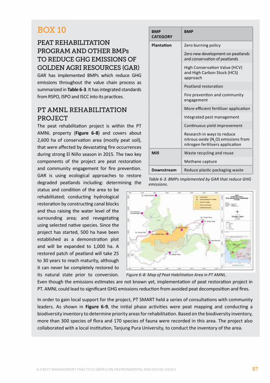
6.0 BEST MANAGEMENT PRACTICES (BMPs) ON ENVIRONMENTAL AND SOCIAL ISSUES 87
BoX 10
peAt rehABIlItAtIon progrAm And other Bmps to reduce ghg emISSIonS of golden AgrI reSourceS (gAr)GAR has implemented BMPs which reduce GHG emissions throughout the value chain process as summarized in Table 6-3. It has integrated standards from RSPO, ISPO and ISCC into its practices.
pt Amnl rehABIlItAtIon proJectThe peat rehabilitation project is within the PT AMNL property (Figure 6-8) and covers about 2,600 ha of conservation area (mostly peat soil), that were affected by devastating fire occurrences during strong El Niño season in 2015. The two key components of the project are peat restoration and community engagement for fire prevention. GAR is using ecological approaches to restore degraded peatlands including: determining the status and condition of the area to be rehabilitated; conducting hydrological restoration by constructing canal blocks and thus raising the water level of the surrounding area; and revegetating using selected native species. Since the project has started, 500 ha have been established as a demonstration plot and will be expanded to 1,000 ha. A restored patch of peatland will take 25 to 30 years to reach maturity, although it can never be completely restored to its natural state prior to conversion. Even though the emissions estimates are not known yet, implementation of peat restoration project in PT. AMNL could lead to significant GHG emissions reduction from avoided peat decomposition and fires.
In order to gain local support for the project, PT SMART held a series of consultations with community leaders. As shown in Figure 6-9, the initial phase activities were peat mapping and conducting a biodiversity inventory to determine priority areas for rehabilitation. Based on the biodiversity inventory, more than 300 species of flora and 170 species of fauna were recorded in this area. The project also collaborated with a local institution, Tanjung Pura University, to conduct the inventory of the area.
BMP CATEGORy
BMP
Plantation Zero burning policy
Zero new development on peatlands and conservation of peatlands
High Conservation Value (HCV) and High Carbon Stock (HCS) approach
Peatland restoration
Fire prevention and community engagement
More efficient fertiliser application
Integrated pest management
Continuous yield improvement
Research in ways to reduce nitrous oxide (N2O) emissions from nitrogen fertilisers application
Mill Waste recycling and reuse
Methane capture
Downstream Reduce plastic packaging waste
Table 6-3: BMPs implemented by GAR that reduce GHG emissions.
Figure 6-8: Map of Peat Habilitation Area in PT AMNL.
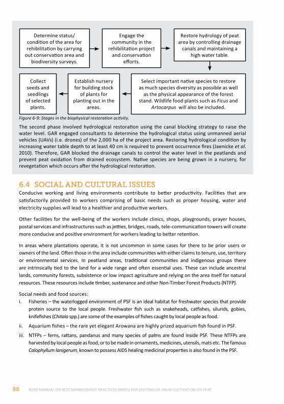
RSPO MANUAL ON BEST MANAGEMENT PRACTICES (BMPs) FOR EXISTING OIL PALM CULTIVATION ON PEAT88
6.4 SocIAl And culturAl ISSueSConducive working and living environments contribute to better productivity. Facilities that are satisfactorily provided to workers comprising of basic needs such as proper housing, water and electricity supplies will lead to a healthier and productive workers.
Other facilities for the well-being of the workers include clinics, shops, playgrounds, prayer houses, postal services and infrastructures such as jetties, bridges, roads, tele-communication towers will create more conducive and positive environment for workers leading to better retention.
In areas where plantations operate, it is not uncommon in some cases for there to be prior users or owners of the land. Often those in the area include communities with either claims to tenure, use, territory or environmental services. In peatland areas, traditional communities and indigenous groups there are intrinsically tied to the land for a wide range and often essential uses. These can include ancestral lands, community forests, subsistence or low impact agriculture and relying on the area itself for natural resources. These resources include timber, sustenance and other Non-Timber Forest Products (NTFP).
Social needs and food sources:i. Fisheries – the waterlogged environment of PSF is an ideal habitat for freshwater species that provide
protein source to the local people. Freshwater fish such as snakeheads, catfishes, silurids, gobies, knifefishes (Chitala spp.) are some of the examples of fishes caught by local people as food.
ii. Aquarium fishes – the rare yet elegant Arowana are highly prized aquarium fish found in PSF.
iii. NTFPs – ferns, rattans, pandanus and many species of palms are found inside PSF. These NTFPs are harvested by local people as food, or to be made in ornaments, medicines, utensils, mats etc. The famous Calophyllum lanigerum, known to possess AIDS healing medicinal properties is also found in the PSF.
Figure 6-9: Stages in the biophysical restoration activity.
Determine status/condition of the area for rehibilitation by carrying
out conservation area and biodiversity surveys.
Collect seeds and seedlings
of selected plants.
Engage the community in the
rehibilitation project and conservation
efforts.
Establish nursery for building stock
of plants for planting out in the
areas.
Restore hydrology of peat area by controlling drainage
canals and maintaining a high water table.
Select important native species to restore as much species diversity as possible as well
as the physical appearance of the forest stand. Wildlife food plants such as Ficus and
Artocarpus will also be included.
The second phase involved hydrological restoration using the canal blocking strategy to raise the water level. GAR engaged consultants to determine the hydrological status using unmanned aerial vehicles (UAVs) (i.e. drones) of the 2,000 ha of the project area. Restoring hydrological condition by increasing water table depth to at least 40 cm is required to prevent occurrence fires (Jaenicke et al. 2010). Therefore, GAR blocked the drainage canals to control the water level in the peatlands and prevent peat oxidation from drained ecosystem. Native species are being grown in a nursery, for revegetation which occurs after the hydrological restoration.
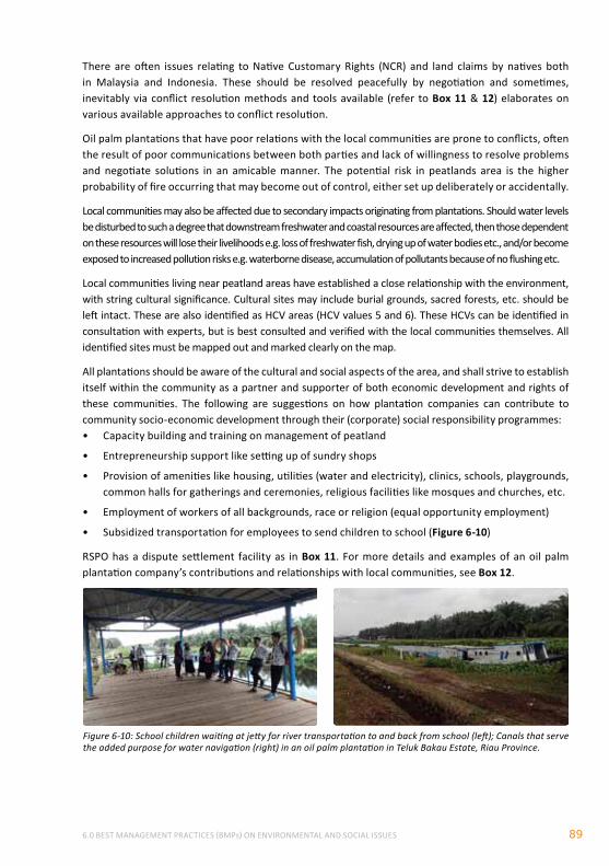
6.0 BEST MANAGEMENT PRACTICES (BMPs) ON ENVIRONMENTAL AND SOCIAL ISSUES 89
Figure 6-10: School children waiting at jetty for river transportation to and back from school (left); Canals that serve the added purpose for water navigation (right) in an oil palm plantation in Teluk Bakau Estate, Riau Province.
There are often issues relating to Native Customary Rights (NCR) and land claims by natives both in Malaysia and Indonesia. These should be resolved peacefully by negotiation and sometimes, inevitably via conflict resolution methods and tools available (refer to Box 11 & 12) elaborates on various available approaches to conflict resolution.
Oil palm plantations that have poor relations with the local communities are prone to conflicts, often the result of poor communications between both parties and lack of willingness to resolve problems and negotiate solutions in an amicable manner. The potential risk in peatlands area is the higher probability of fire occurring that may become out of control, either set up deliberately or accidentally.
Local communities may also be affected due to secondary impacts originating from plantations. Should water levels be disturbed to such a degree that downstream freshwater and coastal resources are affected, then those dependent on these resources will lose their livelihoods e.g. loss of freshwater fish, drying up of water bodies etc., and/or become exposed to increased pollution risks e.g. waterborne disease, accumulation of pollutants because of no flushing etc.
Local communities living near peatland areas have established a close relationship with the environment, with string cultural significance. Cultural sites may include burial grounds, sacred forests, etc. should be left intact. These are also identified as HCV areas (HCV values 5 and 6). These HCVs can be identified in consultation with experts, but is best consulted and verified with the local communities themselves. All identified sites must be mapped out and marked clearly on the map.
All plantations should be aware of the cultural and social aspects of the area, and shall strive to establish itself within the community as a partner and supporter of both economic development and rights of these communities. The following are suggestions on how plantation companies can contribute to community socio-economic development through their (corporate) social responsibility programmes:• Capacity building and training on management of peatland
• Entrepreneurship support like setting up of sundry shops
• Provision of amenities like housing, utilities (water and electricity), clinics, schools, playgrounds, common halls for gatherings and ceremonies, religious facilities like mosques and churches, etc.
• Employment of workers of all backgrounds, race or religion (equal opportunity employment)
• Subsidized transportation for employees to send children to school (Figure 6-10)
RSPO has a dispute settlement facility as in Box 11. For more details and examples of an oil palm plantation company’s contributions and relationships with local communities, see Box 12.
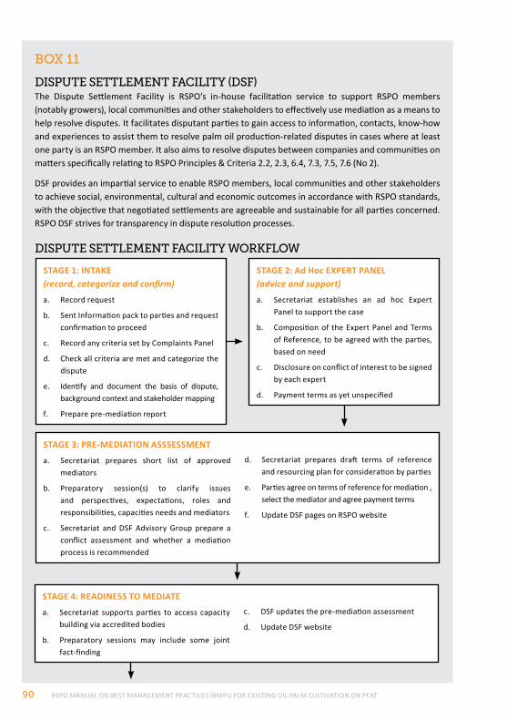
RSPO MANUAL ON BEST MANAGEMENT PRACTICES (BMPs) FOR EXISTING OIL PALM CULTIVATION ON PEAT90
BoX 11
dISpute Settlement fAcIlItY (dSf)The Dispute Settlement Facility is RSPO’s in-house facilitation service to support RSPO members (notably growers), local communities and other stakeholders to effectively use mediation as a means to help resolve disputes. It facilitates disputant parties to gain access to information, contacts, know-how and experiences to assist them to resolve palm oil production-related disputes in cases where at least one party is an RSPO member. It also aims to resolve disputes between companies and communities on matters specifically relating to RSPO Principles & Criteria 2.2, 2.3, 6.4, 7.3, 7.5, 7.6 (No 2).
DSF provides an impartial service to enable RSPO members, local communities and other stakeholders to achieve social, environmental, cultural and economic outcomes in accordance with RSPO standards, with the objective that negotiated settlements are agreeable and sustainable for all parties concerned. RSPO DSF strives for transparency in dispute resolution processes.
dISpute Settlement fAcIlItY workflow
STAGE 2: Ad Hoc EXPERT PANEL(advice and support)
a. Secretariat establishes an ad hoc Expert Panel to support the case
b. Composition of the Expert Panel and Terms of Reference, to be agreed with the parties, based on need
c. Disclosure on conflict of interest to be signed by each expert
d. Payment terms as yet unspecified
STAGE 3: PRE-MEDIATION ASSSESSMENT
a. Secretariat prepares short list of approved mediators
b. Preparatory session(s) to clarify issues and perspectives, expectations, roles and responsibilities, capacities needs and mediators
c. Secretariat and DSF Advisory Group prepare a conflict assessment and whether a mediation process is recommended
d. Secretariat prepares draft terms of reference and resourcing plan for consideration by parties
e. Parties agree on terms of reference for mediation , select the mediator and agree payment terms
f. Update DSF pages on RSPO website
STAGE 1: INTAKE(record, categorize and confirm)
a. Record request
b. Sent Information pack to parties and request confirmation to proceed
c. Record any criteria set by Complaints Panel
d. Check all criteria are met and categorize the dispute
e. Identify and document the basis of dispute, background context and stakeholder mapping
f. Prepare pre-mediation report
STAGE 4: READINESS TO MEDIATE
a. Secretariat supports parties to access capacity building via accredited bodies
b. Preparatory sessions may include some joint fact-finding
c. DSF updates the pre-mediation assessment
d. Update DSF website
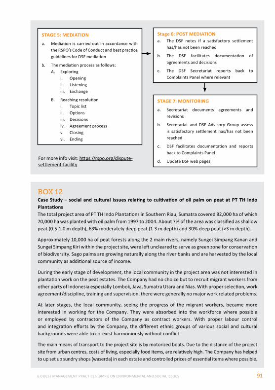
6.0 BEST MANAGEMENT PRACTICES (BMPs) ON ENVIRONMENTAL AND SOCIAL ISSUES 91
BoX 12Case Study – social and cultural issues relating to cultivation of oil palm on peat at PT TH Indo PlantationsThe total project area of PT TH Indo Plantations in Southern Riau, Sumatra covered 82,000 ha of which 70,000 ha was planted with oil palm from 1997 to 2004. About 7% of the area was classified as shallow peat (0.5-1.0 m depth), 63% moderately deep peat (1-3 m depth) and 30% deep peat (>3 m depth).
Approximately 10,000 ha of peat forests along the 2 main rivers, namely Sungei Simpang Kanan and Sungei Simpang Kiri within the project site, were left uncleared to serve as green zone for conservation of biodiversity. Sago palms are growing naturally along the river banks and are harvested by the local community as additional source of income.
During the early stage of development, the local community in the project area was not interested in plantation work on the peat estates. The Company had no choice but to recruit migrant workers from other parts of Indonesia especially Lombok, Java, Sumatra Utara and Nias. With proper selection, work agreement/discipline, training and supervision, there were generally no major work related problems.
At later stages, the local community, seeing the progress of the migrant workers, became more interested in working for the Company. They were absorbed into the workforce where possible or employed by contractors of the Company as contract workers. With proper labour control and integration efforts by the Company, the different ethnic groups of various social and cultural backgrounds were able to co-exist harmoniously without conflict.
The main means of transport to the project site is by motorized boats. Due to the distance of the project site from urban centres, costs of living, especially food items, are relatively high. The Company has helped to up set up sundry shops (waserda) in each estate and controlled prices of essential items where possible.
STAGE 5: MEDIATION
a. Mediation is carried out in accordance with the RSPO’s Code of Conduct and best practice guidelines for DSF mediation
b. The mediation process as follows:A. Exploring
i. Openingii. Listeningiii. Exchange
B. Reaching resolutioni. Topic listii. Optionsiii. Decisionsiv. Agreement processv. Closingvi. Ending
Stage 6: POST MEDIATIONa. The DSF notes if a satisfactory settlement
has/has not been reached
b. The DSF facilitates documentation of agreements and decisions
c. The DSF Secretariat reports back to Complaints Panel where relevant
STAGE 7: MONITORING
a. Secretariat documents agreements and revisions
b. Secretariat and DSF Advisory Group assess is satisfactory settlement has/has not been reached
c. DSF facilitates documentation and reports back to Complaints Panel
d. Update DSF web pagesFor more info visit: https://rspo.org/dispute-settlement-facility
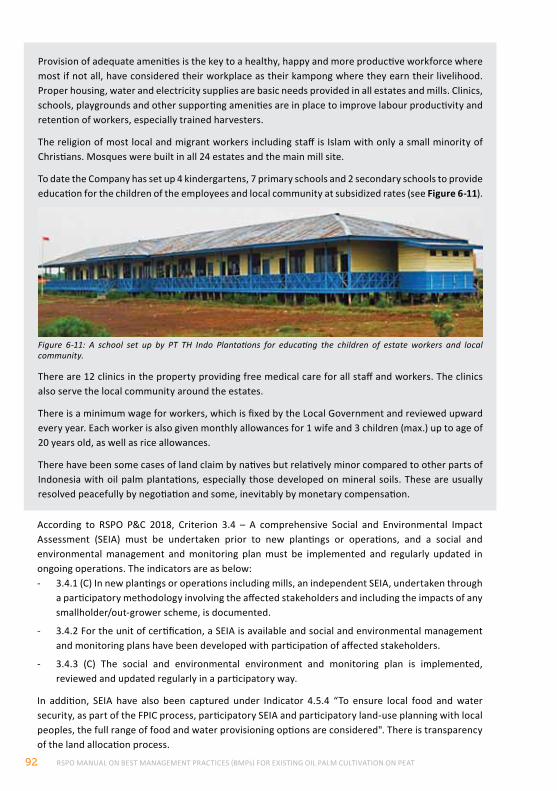
RSPO MANUAL ON BEST MANAGEMENT PRACTICES (BMPs) FOR EXISTING OIL PALM CULTIVATION ON PEAT92
According to RSPO P&C 2018, Criterion 3.4 – A comprehensive Social and Environmental Impact Assessment (SEIA) must be undertaken prior to new plantings or operations, and a social and environmental management and monitoring plan must be implemented and regularly updated in ongoing operations. The indicators are as below:- 3.4.1 (C) In new plantings or operations including mills, an independent SEIA, undertaken through
a participatory methodology involving the affected stakeholders and including the impacts of any smallholder/out-grower scheme, is documented.
- 3.4.2 For the unit of certification, a SEIA is available and social and environmental management and monitoring plans have been developed with participation of affected stakeholders.
- 3.4.3 (C) The social and environmental environment and monitoring plan is implemented, reviewed and updated regularly in a participatory way.
In addition, SEIA have also been captured under Indicator 4.5.4 “To ensure local food and water security, as part of the FPIC process, participatory SEIA and participatory land-use planning with local peoples, the full range of food and water provisioning options are considered". There is transparency of the land allocation process.
Provision of adequate amenities is the key to a healthy, happy and more productive workforce where most if not all, have considered their workplace as their kampong where they earn their livelihood. Proper housing, water and electricity supplies are basic needs provided in all estates and mills. Clinics, schools, playgrounds and other supporting amenities are in place to improve labour productivity and retention of workers, especially trained harvesters.
The religion of most local and migrant workers including staff is Islam with only a small minority of Christians. Mosques were built in all 24 estates and the main mill site.
To date the Company has set up 4 kindergartens, 7 primary schools and 2 secondary schools to provide education for the children of the employees and local community at subsidized rates (see Figure 6-11).
There are 12 clinics in the property providing free medical care for all staff and workers. The clinics also serve the local community around the estates.
There is a minimum wage for workers, which is fixed by the Local Government and reviewed upward every year. Each worker is also given monthly allowances for 1 wife and 3 children (max.) up to age of 20 years old, as well as rice allowances.
There have been some cases of land claim by natives but relatively minor compared to other parts of Indonesia with oil palm plantations, especially those developed on mineral soils. These are usually resolved peacefully by negotiation and some, inevitably by monetary compensation.
Figure 6-11: A school set up by PT TH Indo Plantations for educating the children of estate workers and local community.

6.0 BEST MANAGEMENT PRACTICES (BMPs) ON ENVIRONMENTAL AND SOCIAL ISSUES 93
6.5 cooperAtIon wIth locAl communItIeSIt is often heard that many plantations find it extremely challenging in trying to recruit workers from their community area. The reasons often cited by plantations include the differences in expectations between many communities and the estate.
Often individuals in the community may be involved in part-time or casual work, such as seasonal labour. Such an arrangement is suited to many as it allows time for tending to their own land; often cultivated with cash crops like rubber or oil palm and fruit orchards.
Plantations may find cost-benefits from increasing its sourcing of food with local content. Many communities often lack resources and capacity in entrepreneurial ventures. Plantations may be pivotal in raising capacity of communities in trade, tourism, marketing and agronomic practices.
Relevant sections of the Indonesian Sustainable Palm Oil (ISPO) Principles and Criteria are as follows:
prIncIple 5: SocIAl reSponSIBIlItY And communItYCRITERION 5.1 Social responsibility and social environment – Plantation managers should have a commitment to social and community development as well as development of local knowledge.
INDICATORSi. Commitment to social responsibility and social environments in accordance with prevailing
norms in local society available
ii. Records of realization of commitments to social responsibility and social environments
GUIDANCEi. Improving the quality of life and environment that benefits both the company itself, local
communities and society in general
ii. Participate in improving the welfare of the community through partnerships
iii. Implement developments around the estate through various activities such as education, health, infrastructure, agriculture, small and micro enterprises, sports, arts, religion, socioeconomics, etc.
CRITERION 5.2 Empowerment of Indigenous Peoples/Local communities – Plantation manager plays a role in increasing the welfare of indigenous peoples/local communities
INDICATORSi. Have programs to increase the welfare of indigenous peoples
ii. Have programs to preserve local knowledge
iii. Records related to the realization of indigenous peoples programs available
GUIDANCEi. Having a role in empowering indigenous peoples
ii. Providing employment and prioritize opportunities to local communities
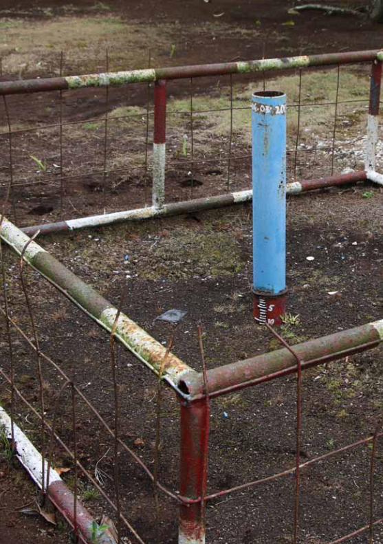
RSPO MANUAL ON BEST MANAGEMENT PRACTICES (BMPs) FOR EXISTING OIL PALM CULTIVATION ON PEAT94
7.0 BEST MANAGEMENT PRACTICES (BMPs) ON RESEARCH AND DEVELOPMENT, MONITORING AND DOCUMENTATION 95
7.0 BEST MANAGEMENT PRACTICES (BMPs) ON RESEARCH ANd dEVELOPMENT, MONITORING ANd dOCUMENTATION
This chapter focuses on practical guidance based on agronomic experience and practical knowledge on the following BMP topics: research and development needs, monitoring, reporting and proper documentation of operating procedures.
7.1 reSeArch And developmentResearch and development (R&D) is vital for continual improvement of BMPs for oil palm cultivation on peatland.
The task of increasing productivity, efficiency while minimizing adverse impacts of oil palm plantations on peat poses a great challenge to researchers and planters. Also, since no new development on peatlands is currently allowed under the RSPO P&C, new opportunities for rehabilitation and sustainable use of such peat areas need to be explored. Large companies with substantial peat plantings e.g. United Plantations, Tradewinds Plantations and PT TH Indo Plantations have set up their own in-house Research and Advisory Departments to meet these needs. Others may opt for third-party agronomists for advisory services.
More applied research is vital to enhance the potential of decreasing environmental impacts of oil palm cultivation on peat, as well as specific research on alternative use. Cost-effective innovations are continuously needed to meet the many challenges of oil palm cultivation on peatland. Planters with practical experience can also play a role in developing new peat technologies rather than just leaving it to agronomists and researchers – include engaging specialists/experts for studies on biological diversity such as mammals, birds, flora, in particular Rare, Threatened and Endangered (RTE) species and aquatic biodiversity.
reSeArch AreASThe following research areas are suggested to increase sustainability for oil palm cultivated on peat:
• Replacement of harmful chemicals and pesticides by more organic and/or biological treatments
• Introducing contour drainage, but also fish-bone drainage layouts and other innovations related to water management
• Developing alternate crops or cropping system that allow economic use of peat and high water tables (paludiculture)
• Research on management of the growing land-bank of set-aside areas for a healthy plantation
• Cost effective water level monitoring techniques
• Use of drones, UAVs and remote sensing to assessing and monitoring palm health, fires, water tables etc.
• Low-cost but accurate land elevation survey techniques
• Composting innovations
• Capture and use of methane
• Nutritional trials to establish the optimum nutrient ratios of N, K, and B for different stages of oil palm development on different types of peat
RSPO MANUAL ON BEST MANAGEMENT PRACTICES (BMPs) FOR EXISTING OIL PALM CULTIVATION ON PEAT96
• Research on Ganoderma management on peat, to find early detection and prevention techniques
• Selection and breeding of palm tolerant to Ganoderma BSR to be intensified
• Monitoring and decreasing GHG emissions on developed peat
• Monitoring on biodiversity within HCV, HCS, peat and aquatic ecosystems as indicators of improvement on conservation
7.2 monItorIng And reportIngBy law, oil palm plantation companies are required to monitor and report on environmental and social impacts of their developments in the form of environmental and/or social management plans. This is especially important for cultivation on peatland, an environmentally sensitive ecosystem with complex hydrological regimes.
As of the RSPO P&C 2018 requirements, the plantation companies should comply with the following:
Plans and impact assessments relating to environmental and social impacts:• Main social and environmental impacts and mitigation measures
Monitoring:• Social and Environmental Impact Assessment / HCV assessment before replanting
• Topographic surveys and peat delineation
• Monitoring of soils subsidence
• Water management / water levels /hydrology
• Set-aside areas
• Annual reporting of GHG emissions and progress in implementing GHG emission reduction plan
• Maintaining and periodically updating maps (peat, land use, HCV etc.)
• Implementation of management plans.
• Drainability Assessment
• Annual replanting programme (required and projected for a minimum of 5 years for mineral soils and for peat soils a longer term programme is required).
SuBSIdenceAn important effect of drainage is the subsidence of the peat surface. Subsidence is the result of consolidation, oxidation and shrinkage of the organic materials because of drainage. In tropical peatlands, biological oxidation is the main contributor to subsidence (Andriesse, 1988) with estimated long term contributions up to 90% (Stephens et al., 1984; Hooijer et al., 2012). Subsidence cannot be stopped as long as the water table is below the peat surface (Tie, 2004). Deeper drainage results in higher subsidence rates. Subsidence can be decreased by high water tables during the entire year, sufficient ground cover and avoidance of fire. It is important to keep track on soil subsidence in a plantations, and therefore RSPO requires growers to monitor soil subsidence.
meASurement of peAt SuBSIdenceThe measurement of peat subsidence can be done by installing a vertical pole made of long lasting material into the peat. It is important to ensure that the subsidence pole is installed firmly into the mineral substratum (minimum of 50 cm) for anchorage. A layer of concrete, or other permanent marker can act as a marker of the initial soil surface height (Figure 7-1).
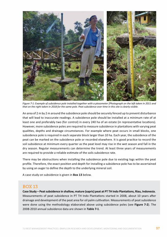
7.0 BEST MANAGEMENT PRACTICES (BMPs) ON RESEARCH AND DEVELOPMENT, MONITORING AND DOCUMENTATION 97
Figure 7-1: Example of subsidence pole installed together with a piezometer [Photograph on the left taken in 2011 and that on the right taken in 2018 for the same pole. Peat subsidence over time in this site is clearly visible.
BoX 13Case Study – Peat subsidence in shallow, mature (sapric) peat at PT TH Indo Plantations, Riau, Indonesia.Measurements of peat subsidence in PT TH Indo Plantations started in 2008, about 10 years after drainage and development of the peat area for oil palm cultivation. Measurements of peat subsidence were done using the methodology elaborated above using subsidence poles (see Figure 7-2). The 2008-2010 annual subsidence data are shown in Table 7-1.
An area of 2 m by 2 m around the subsidence pole should be securely fenced up to prevent disturbance that will lead to inaccurate readings. A subsidence pole should be installed at a minimum rate of at least one and preferably two (for control) in every 240 ha of an estate (in representative locations). However, more subsidence poles are required to measure subsidence in plantations with varying peat qualities, depths and drainage circumstances. For example where peat occurs in small blocks, one subsidence pole is required in each separate block larger than 10 ha. Each year, the subsidence of the peat can be marked on the subsidence pole or recorded elsewhere. It is good practice to record the soil subsidence at minimum every quarter as the peat level may rise in the wet season and fall in the dry season. Regular measurements can determine the trend. At least three years of measurements are required to provide a reliable estimate of the soils subsidence rate.
There may be obstructions when installing the subsidence pole due to existing logs within the peat profile. Therefore, the exact position and depth for installing a subsidence pole has to be ascertained by using an auger to define the depth to the underlying mineral soil.
A case study on subsidence is given in Box 13 below.
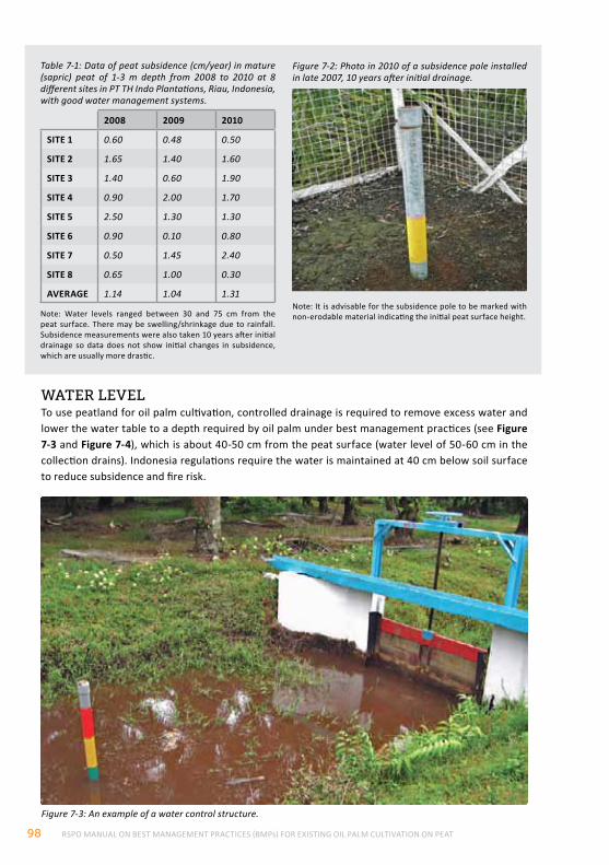
RSPO MANUAL ON BEST MANAGEMENT PRACTICES (BMPs) FOR EXISTING OIL PALM CULTIVATION ON PEAT98
wAter levelTo use peatland for oil palm cultivation, controlled drainage is required to remove excess water and lower the water table to a depth required by oil palm under best management practices (see Figure 7-3 and Figure 7-4), which is about 40-50 cm from the peat surface (water level of 50-60 cm in the collection drains). Indonesia regulations require the water is maintained at 40 cm below soil surface to reduce subsidence and fire risk.
Figure 7-3: An example of a water control structure.
Table 7-1: Data of peat subsidence (cm/year) in mature (sapric) peat of 1-3 m depth from 2008 to 2010 at 8 different sites in PT TH Indo Plantations, Riau, Indonesia, with good water management systems.
2008 2009 2010
SITE 1 0.60 0.48 0.50
SITE 2 1.65 1.40 1.60
SITE 3 1.40 0.60 1.90
SITE 4 0.90 2.00 1.70
SITE 5 2.50 1.30 1.30
SITE 6 0.90 0.10 0.80
SITE 7 0.50 1.45 2.40
SITE 8 0.65 1.00 0.30
AVERAGE 1.14 1.04 1.31
Note: Water levels ranged between 30 and 75 cm from the peat surface. There may be swelling/shrinkage due to rainfall. Subsidence measurements were also taken 10 years after initial drainage so data does not show initial changes in subsidence, which are usually more drastic.
Figure 7-2: Photo in 2010 of a subsidence pole installed in late 2007, 10 years after initial drainage.
Note: It is advisable for the subsidence pole to be marked with non-erodable material indicating the initial peat surface height.
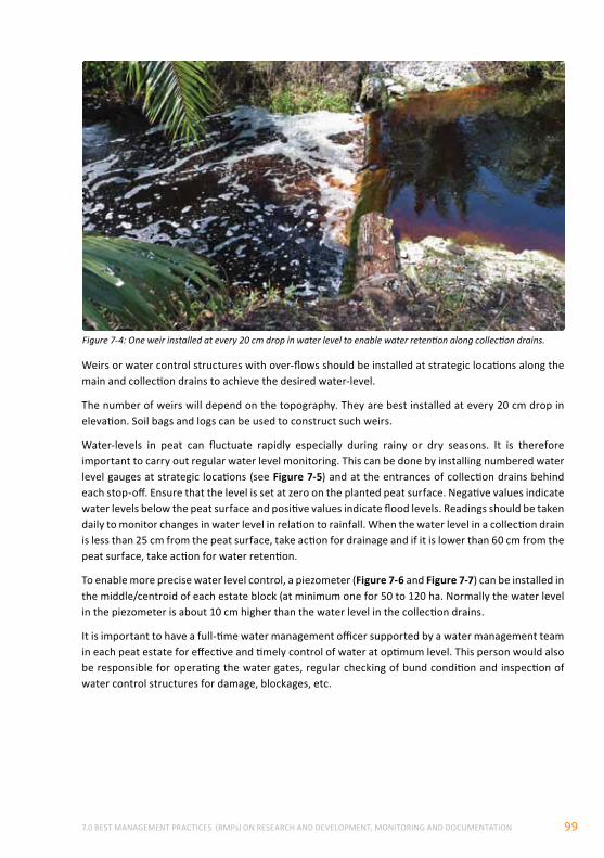
7.0 BEST MANAGEMENT PRACTICES (BMPs) ON RESEARCH AND DEVELOPMENT, MONITORING AND DOCUMENTATION 99
Weirs or water control structures with over-flows should be installed at strategic locations along the main and collection drains to achieve the desired water-level.
The number of weirs will depend on the topography. They are best installed at every 20 cm drop in elevation. Soil bags and logs can be used to construct such weirs.
Water-levels in peat can fluctuate rapidly especially during rainy or dry seasons. It is therefore important to carry out regular water level monitoring. This can be done by installing numbered water level gauges at strategic locations (see Figure 7-5) and at the entrances of collection drains behind each stop-off. Ensure that the level is set at zero on the planted peat surface. Negative values indicate water levels below the peat surface and positive values indicate flood levels. Readings should be taken daily to monitor changes in water level in relation to rainfall. When the water level in a collection drain is less than 25 cm from the peat surface, take action for drainage and if it is lower than 60 cm from the peat surface, take action for water retention.
To enable more precise water level control, a piezometer (Figure 7-6 and Figure 7-7) can be installed in the middle/centroid of each estate block (at minimum one for 50 to 120 ha. Normally the water level in the piezometer is about 10 cm higher than the water level in the collection drains.
It is important to have a full-time water management officer supported by a water management team in each peat estate for effective and timely control of water at optimum level. This person would also be responsible for operating the water gates, regular checking of bund condition and inspection of water control structures for damage, blockages, etc.
Figure 7-4: One weir installed at every 20 cm drop in water level to enable water retention along collection drains.
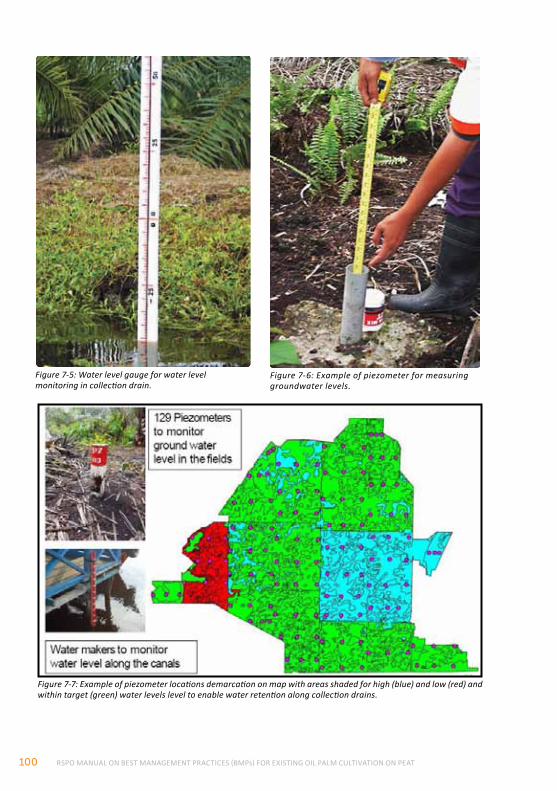
RSPO MANUAL ON BEST MANAGEMENT PRACTICES (BMPs) FOR EXISTING OIL PALM CULTIVATION ON PEAT100
Figure 7-7: Example of piezometer locations demarcation on map with areas shaded for high (blue) and low (red) and within target (green) water levels level to enable water retention along collection drains.
Figure 7-5: Water level gauge for water level monitoring in collection drain.
Figure 7-6: Example of piezometer for measuring groundwater levels.
7.0 BEST MANAGEMENT PRACTICES (BMPs) ON RESEARCH AND DEVELOPMENT, MONITORING AND DOCUMENTATION 101
ghg emISSIonSubsidence also involves GHG emissions. The oxidation process described as a result of drainage leads to CO2 emissions of 35 to more than 80 tonnes of CO2 / ha/year (depending on peat type, drainage depth, soil temperature and other factors) and thus removal of the soil carbon resulting in subsidence. Therefore, minimization of drainage is important to reduce GHG emissions. However, even with an optimal drainage of 40-60 cm in the field, oil palm plantations will still have a significant carbon footprint of about 45 tonnes of CO2 / ha/year (derived from Page et al., 2011, Hoojier et al., 2011, Jauhiainen et al., 2012). In general, maintaining a high water level as much as the oil palms can tolerate will help to reduce peat subsidence and CO2 emissions.
7.3 documentAtIon of operAtIng procedureS
Documentation of BMPs and inclusion of this information in oil palm plantation companies’ standard operating procedures (SOPs) is the key to effective implementation of these BMPs. This is in line with RSPO P&C 2018 Criterion 3.2 (The unit of certification regularly monitors and reviews their economic, social and environmental performance and develops and implements action plans that allow demonstrable continuous improvement in key operations), Criterion 3.3 (Operating procedures are appropriately documented and consistently implemented and monitored). This practice is also good for maintaining continuity in operations i.e. plantation staff changes will not affect operations.
.
RSPO MANUAL ON BEST MANAGEMENT PRACTICES (BMPs) FOR EXISTING OIL PALM CULTIVATION ON PEAT102
8.0 REFERENCES AGUS, F., GUNARSO, P., SAHARDJO, B. H., JOSEPH, K. T., RASHID, A., HAMZAH, K., HARRIS, N. & VAN NOORDWIJK, M. 2011. Reducing greenhouse gas emissions from land use changes for oil palm development. Presentation to plenary session, RSPO RT9, November 2011.
ALSHAMMARI, L., LARGE, D., BOYD, D., SOWTER, A., ANDERSON, R., ANDERSEN, R., & MARSH, S. 2018. Long-term peatland condition assessment via surface motion monitoring using the ISBAS DInSAR technique over the Flow Country, Scotland. Remote Sensing, 10(7), 1103.
ANDERSON, J. A. R. 1961. The ecology and forest types of peat swamp forests of Sarawak and Brunei in relation to their silvicuture. Ph.D. Thesis, University of Edinburgh, UK.
ANDERSON, J. A. R. 1964. The structure and development of the peat swamps of Sarawak and Brunei. J. Trop. Geography, 18, pp 7-16.
ANDRIESSE, J.P. 1988. Nature and management of tropical peat soils. fao Soils Bulletin 59. Food and Agriculture Organization of the United Nations, Rome. pp 165.
ARN TEH, Y., MANNING, F., ZIN ZAWAWI, N., COOK, S., HILL, T., & KHOON KHO, L. 2018. Towards a full greenhouse gas balance of managed tropical peatlands in northern Borneo. In EGU General Assembly Conference Abstracts (Vol. 20, p. 17566), April 2018.
ASEAN SECRETARIAT, 2003. Guidelines for the Implementation of the ASEAN Policy on Zero Burning. The ASEAN Secretariat, Jakarta.
ARN TEH, Y., MANNING, F., ZIN ZAWAWI, N., COOK, S., HILL, T., & KHOON KHO, L. 2018, April. Towards a full greenhouse gas balance of managed tropical peatlands in northern Borneo. In EGU General Assembly Conference Abstracts (Vol. 20, p. 17566).
ATTANANDANA, T. and VACHAROTAYAN, S. 1986. Acid Sulfate Soils: Their Characteristics, Genesis, Southeast Asian Studies, VOL. 24, NO.2, September 1986.
BASRI, M.W. 1995. Integrated Pest Management of Bagworms in oil palm plantations. 1995 PORIM National Oil Palm Conference, Kuala Lumpur, 11-12 July 1995.
BEAUDOIN-OLLIVIER, L. ISIDORO, N. JAQUES, J.A., RIOLO, P. KAMAL, M and ROCHAT, D. 2017. Some Representative Palm Pests: Ecological and Practical Data. Chapter 1 in Soroker, V and Colazza S. Handbook of Major Palm Pests: Biology and Management.
BHOMIA, R.K., VAN LENT, J., RIOS, J.M.G. 2018. Impacts of Mauritia flexuosa degradation on the carbon stocks of freshwater peatlands in the Pastaza-Marañón river basin of the Peruvian Amazon. Mitig Adapt Strateg Glob Change https://doi.org/10.1007/s11027-018-9809-9
BORD, N, M. 1984. Fuel Peat in Developing Countries. Dublin, Ireland.
CARLSON, K. M., GOODMAN, L. K., & MAY-TOBIN, C. C. 2015. Modeling relationships between water table depth and peat soil carbon loss in Southeast Asian plantations. Environmental Research Letters, 10(7), 074006.
CHUNG, G. F. and SIM, S. C. 1994. Crop protection practices in oil palm plantations. International Planters Conference 24-26 October 1994.
COOK, S., WHELAN, M. J., EVANS, C. D., GAUCI, V., PEACOCK, M., GARNETT, M. H.,& PAGE, S. E. 2018. Fluvial organic carbon fluxes from oil palm plantations on tropical peatland. Biogeosciences, 15(24), 7435-7450.
COOPER HV, EVERS S, APLIN P, CROUT N, DAHALAN MPB, SJOGERSTEN S (In Prep) Greenhouse gas emissions peak during conversion of peat swamp forest to oil palm plantation.
COOPER, H. V., VANE, C. H., EVERS, S., APLIN, P., GIRKIN, N. T., & SJÖGERSTEN, S. 2019. From peat swamp forest to oil palm plantations: The stability of tropical peatland carbon. Geoderma, 342. https://doi.org/10.1016/j.geoderma.2019.02.021
COUWENBERG, J., DOMMAIN, R. & JOOSTEN, H. 2010. Greenhouse gas fluxes from tropical peatlands in south-east Asia. Global Change Biology, 16, 1715-1732.
DANIELSEN, S. et al. 2008. Biofuel plantations on forested lands: Double jeopardy for biodiversity and climate. Conservation Biology 23(2) pp 348-358.
DARGIE, G. C., LEWIS, S. L., LAWSON, I. T., MITCHARD, E. T., PAGE, S. E., BOCKO, Y. E., & IFO, S. A. 2017. Age, extent and carbon storage of the central Congo Basin peatland complex. Nature, 542(7639), 86.
8.0 REFERENCES 103
DEWHURST I.C. and MARRS T.C. 2011 Toxicology of Pesticides. General, Applied and Systems Toxicology. John Wiley & Sons DOI: 10.1002/9780470744307
DE VRIES, C., VAN DE VEN, G. J. W., ITTERSUM, M. K. et al. 2010. Resource use efficiency and environmental performance of nine major biofuel crops, processed by first-generation conversion techniques. In: Biomass and Bioenergy 34 (2010) pp 588-601.
D’CRUZ, REBECCA 2014. Guidelines on Integrated Management Planning for Peatland Forests in Southeast Asia. ASEAN Peatland Forests Project and Sustainable Management for Peatlands Forests Project. Association of Southeast Asian Nations and Global Environment Centre
DID MALAYSIA. 1996. Western Johore Integrated Agricultural Development Project, Peat Soil Management Study, Department of Irrigation and Drainage, Kuala Lumpur and Land and Water Research Group (LAWOO), Wageningen, pp 100.
DRAPER, F. C., ROUCOUX, K. H., LAWSON, I. T., MITCHARD, E. T., CORONADO, E. N. H., Lähteenoja, O., & BAKER, T. R. 2014. The distribution and amount of carbon in the largest peatland complex in Amazonia. Environmental Research Letters, 9(12), 124017.
DRIESSEN, P.M. 1978. Peat soils. Soils and Rice. International Rice Research Institute, Los Banos, Philippines. pp 763-779.
DUCKETT, J. E. and KARUPPIAH, S. 1990. A guide to the planter in utilising barn owls Tyto alba as an effective biological control of rats in mature oil palm plantations. In Proc. of 1989 Int. Palm Oil Dev. Conf. - Agriculture (Module II) (Jalani, S., Zin Zawawi, Z., Paranjothy, K., Ariffin, D., Rajanaidu, N., Cheah, S.C., Mohd. Basri, W. and Henson, I.E., eds.). Palm Oil Research Institute of Malaysia, Kuala Lumpur. pp 357- 372.
EVANS, C. D., WILLIAMSON, J. M., KACARIBU, F., IRAWAN, D., SUARDIWERIANTO, Y., HIDAYAT, M. F. & PAGE, S. E. 2019. Rates and spatial variability of peat subsidence in Acacia plantation and forest landscapes in Sumatra, Indonesia. Geoderma, 338, 410-421.
EVERS, S., YULE, C. M., PADFIELD, R., O’REILLY, P., & VARKKEY, H. 2017. Keep wetlands wet: the myth of sustainable development of tropical peatlands – implications for policies and management. Global Change Biology, 23(2). https://doi.org/10.1111/gcb.13422
FARGIONI, J., HILL, J., TILMAN, D., POLASKY, S., HAWTHORNE, P. 2008. Land clearing and the biofuel carbon debt. Science 319(29) pp 1235-1238.
FAO/ISRIC/ISSS, 1998: World Reference Base for Soil Resources. World Soil Resources Report, #84. FAO, Rome, 88pp.
FLOOD, J., YONNES, H. AND FOSTER, H. 2002. Ganoderma diseases of oil palm - An interpretation from Bah Lias Research Station. The Planter, 78 (921): pp 689-710.
FURUKAWA, Y., INUBUSHI, K., ALI, M., ITANG, A. M., & TSURUTA, H. 2005. Effect of changing groundwater levels caused by land-use changes on greenhouse gas fluxes from tropical peat lands. Nutrient Cycling in Agroecosystems, 71, 81-91.
GAN,L.T., PARISH, F., CAI,H.,TAN,J. 2018. Towards Low GHG Emission in New Oil Palm Development – Results of RSPO's Approach. The Planter 94 (1105):225-238.
GIBBS, H. K., JOHNSTON, M., FOLEY, J. A., et al. 2008. Carbon payback times for crop-based biofuel expansion in the tropics: the effects of changing yield and technology.
GURMIT, S., TAN Y.P., RAJAH PADMAN, C.V. and LEE, F.W. 1986. Experiences on the cultivation and management of oil palms on deep peat in United Plantations Berhad. 2nd International Soil Management Workshop: Classification, Characterization and Utilization of Peat land, Haadyai, Thailand.
GURMIT, S. 1999. Agronomic management of peat soil for sustainable oil palm production. Seminar on various aspects of large scale oil palm cultivation on peat soil. 23 October 1999, ISP, Sibu, Sarawak.
HENSON, I. E. 2009. Modeling carbon sequestration and greenhouse gas emissions associated with oil palm cultivation and land use change in Malaysia. A reevaluation and a computer model. MPOB Technology.
HEW, C.K. and KHOO, K.M. 1970. Some methods of improving oil palms on acid sulphate soils in West Malaysia. In: Proc. 1st ASEAN Soil Conf., Bangkok, Thailand, Paper No.38: 1 - 32.
HIRANO, T., SEGAH, H., HARADA, T., LIMIN, S., JUNE, T., HIRATA, R., & OSAKI, M. 2007. Carbon dioxide balance of a tropical peat swamp forest in Kalimantan, Indonesia. Global Change Biology, 13(2), 412-425.
RSPO MANUAL ON BEST MANAGEMENT PRACTICES (BMPs) FOR EXISTING OIL PALM CULTIVATION ON PEAT104
HO, C. T. and KHAIRUDIN, H. 1997. Usefulness of soil mounding treatments in prolonging productivity of prime-aged Ganoderma infected palms. The Planter, 73 (854): pp 239-24
HO, C. T. and TEH, C. H. 2004. Containment and Control of Rhinoceros Beetles and Ganoderma Basal Stem Rot. In: Proc. Of Agronomy and Crop Management Workshops (Chew, P. S. and TAN, Y. P., ed.) MOSTA, pp 195-211.
HO, C. T. and TEH, C. L. 1997. Integrated pest management in plantation crops in Malaysia challenges and realities. In Proceedings of the 1997 International Planters Conference – Plantation Management for the 21st Century (VOLUME 1) (E. Pushparajah, eds.) pp 125-149.
HOOIJER, A., PAGE, S. E., CANADELL, J. G., SILVIUS, M., KWADI JK, J., WÖSTEN, H. and JAUHIAINEN, J. 2010. Current and future CO2 emissions from drained peatlands in Southeast Asia. Biogeosciences, 7, pp 1-10.
HOOIJER, A., PAGE, S. E., JAUHIAINEN, J., LEE, W. A., IDRIS, A., & ANSHARI, G. 2011. Land subsidence and carbon loss in plantations on tropical peatland: reducing uncertainty and implications for emission reduction options. Biogeosciences Discussions.
HOOIJER, A., PAGE, S. E., JAUHIAINEN, J., LEE, W. A., LU, X. X., IDRIS, A. and ANSHARI, G. 2012. Subsidence and carbon loss in drained tropical peatlands. Biogeosciences, 9, pp 1-19.
HOONG, H. 2007. Ganoderma disease of oil palm in Sabah. Planter, 83(974), 299-313.
IDRIS, A. S. 2004. Control of Ganoderma infected palms with hexaconozole. Paper presented at the 3rd Meeting of the MPOB/Industry Research Committee on Ganoderma in Sabah and Sarawak. 11 February 2004.
INTERNATIONAL SOCIETY OF SOIL SCIENCE –IUSS. 1930. Report to The Subcommission for Peat Soils of The International Society of Soil Science. Washington D.C., USA, U.S. Bureau of Chemistry and Soils
ISMAIL, A. B. 1984. Characterization of lowland organic soil in Peninsular Malaysia. Paper presented at the Workshop on Classification and Management of Peat in Malaysia, Kuala Lumpur.
IUSS WORKING GROUP WRB 2006/07. ‘World Reference Base for Soil Resources 2006. A framework for international classification correlation and communication’. World Soil Resources Reports 103. (FAO: Rome). Electronic update 2007. http://www.fao.org/ag/agl/agll/wrb/
JAENICKE, J., RIELEY, J. O., MOTT, C. et al. 2008. Determination of the amount of carbon stored in Indonesian peatlands. In: Geoderma 147 (2008) pp 151-158.
JAENICKE, J., WÖSTEN, H., BUDIMAN, A., & SIEGERT, F. 2010. Planning hydrological restoration of peatlands in Indonesia to mitigate carbon dioxide emissions. Mitigation and Adaptation Strategies for Global Change, 15(3), 223-239.
JAUHIAINEN, J., HOOI JER, A. and PAGE, S. E. 2012. Carbon dioxide emissions from an Acacia plantation on peatland in Sumatra, Indonesia. Biogeosciences, 9, pp 617–630.
KAMARUDIN, N., MSLIM, R., MASRI, M, MAZMIRA, M. and ABU SEMAN, I. 2016. Current challenges on pests and diseases of oil palm cultivation. Conference proceedings.
KELLY, THOMAS & LAWSON, IAN & ROUCOUX, K & R. BAKER, TIMOTHY & D. JONES, TIMOTHY & SANDERSON, NICOLE. 2016. The vegetation history of an Amazonian domed peatland. Palaeogeography Palaeoclimatology Palaeoecology. 468.10.1016/j.palaeo.2016.11.039
LÄHTEENOJA, OUTI & PAGE, SUSAN. 2011. High diversity of tropical peatland ecosystem types in the Pastaza-Maraón basin, Peruvian Amazonia. Journal of Geophysical Research. 116.10.1029/2010JG001508.
LE, P. Q. 2010. Inventory of peatlands in U Minh Ha Region, Ca Mau Province, Vietnam. Institute for Environment and Natural Resources, National University, HCM City.
LEAMY, M. L., & PANTON, W. P. 1966. Soil survey manual for Malayan conditions. Ministry of Agriculture and Cooperatives (Malaysia), Division of Agric. Bull, 119.
LIAU, S. S. 1994. Rat population in oil palm replants and crop loss assessment. In: Proc. Third Int. Conf. on Plant Protection in the Tropics, Vol IV. Malaysian Plant Protection Society, KL. pp 8-18.
LIAU, S. S. and AHMAD, A. 1995. Defoliation and crop loss in young oil palms. In Proc. of 1993 PORIM Int.P.O. Cong. ‘Update and Vision’ – Agriculture (Jalani, S., Ariffin, D., Rajanaidu, N., Mohd Tayeb, D., Paranjothy, K., Mohd. Basri, W., Henson, I. E. & Chang K. C., eds.). Palm Oil Research Institute of Malaysia, KL. pp 408-427.
LIEW, S. F. 2010. A fine balance: Stories from peatland communities in Malaysia. MPOC, Selangor, Malaysia.
8.0 REFERENCES 105
LIM K.H. 2011. An integrated approach of controlling the Thirathaba bunch moth on oil palms planted on peat. Paper presented at Int. Palm Oil Congr. 'Palm oil: fortifying and energising the world'. Malaysian Palm Oil Board, Kuala Lumpur, 15 - 17 November 2011.
LIM, K.H. 2005A. Soil, water and fertilizer management for oil palm cultivation on peat soils. In: Proc. Pipoc 2005 International Palm Oil Congress, Biotechnology and Sustainability Conf. 26-28 SEPT. 2005. pp 433-455.
LIM, K.H. 2005B. Integrated pest and disease management of oil palm on peat soils. The Planter, 81 (956): pp 671-686.
LIM, K.H. 2003. Agronomic management of oil palm planted on deep peat in Sarawak. MOSTA Seminar on Recent Advances in the Oil Palm Sector: Agriculture, Plantation Management, End Uses and Nutrition, 8-9 May 2003, Sandakan, Sabah, Malaysia.
LIM, K. H. 2002. R & D Focus: Oil palm planting on deep peat in Sarawak. MPOA Seminar 2002 – R & D for Competitive Edge in the Malaysian Oil Palm Industry. 19-20 March 2002, Bangi, Selangor, Malaysia.
LIM, K. H. and BIT, S. 2001. Termite infestations on oil palms planted on deep peat in Sarawak : Tradewinds Experience. In: Proc. 2001 Pipoc International Palm Oil Congress (Agriculture Conference). Organised by MPOB, Kuala Lumpur. pp 355-368.
LIM, K.H., BIT, S. AND HI I, J. M. 2003. Trials on fertilizer protection under high rainfall conditions. In: Proc. PIPOC 2003 Int. Palm Oil Congress-Agric. Conf. Organised by MPOB at Putra Jaya, Malaysia. pp 899- 916.
LIM K. H., CHUAH, J. H. and HO, C. H. 1993. Effects of soil heaping on Ganoderma infected palms. In: Proceedings of the 1993 PORIM International Palm Oil Congress “Update and Vision” (Agriculture), 20-25 SEPTEMBER 1993. Palm Oil Research Institute of Malaysia, Kuala Lumpur. pp 367-383.
LIM, K.H., GOH, K. J., KEE, K.K. and HENSON, I .E. 2004. Climatic effects on oil palm performance and some ameliorating measures. MOSTA Workshop on Agronomy & Crop Mgt., 10 July 2004, Teluk Intan, Perak, Malaysia.
LIM, K. H. and HERRY, W. 2010. Management of leaning and fallen palms planted on tropical peat. Presented at the International Oil Palm Conference 2010. 1-3 June 2010, Yogyakarta, Indonesia. Organized by IOPRI.
LIM, K. H. and SILEK, B. 2001. Termite infestation on oil palms planted on deep peat in Sarawak: Tradewinds experience. In: Proceedings of the International Palm Oil Congress - Cutting-edge Technology for Sustained Competitiveness (Wahid, M B, Ravigadevi, S, Rabiah, S S and Alwee, S, eds.) Kuala Lumpur, 2001. Malaysian Palm Oil Board,Kuala Lumpur. 355-368.
LIM, K. H. and UDIN. W. 2010. Ganoderma basal and middle stem rot and its management on first generation oil palms planted on peat. Presented at the Second International Seminar on Oil Palm Diseases. 31 May 2010, Yogyakarta, Indonesia. Organized by IOPRI and MPOB.
MANJ IT, S., ZULKASTA, S. and ABDUL, H. 2004. Yield responses of young mature oil palms to NPK fertiliser application on deep peat in North Sumatra Province, Indonesia. The Planter 80 (941): pp 489-506.
MANNING, F., LIP KHOON, K., HILL, T., & ARN TEH, Y. 2017. Methane and CO2 fluxes from peat soil, palm stems and field drains in two oil palm plantations in Sarawak, Borneo, on different tropical peat soil types. In EGU General Assembly Conference Abstracts (Vol. 19, p. 16600).
MARKOV, VD., OLUNIN, AS., OSPENNIKOVA, LA., SKOBEEVA, EI., KHOROSHEV, PI. 1988. World Peat Resources. Moscow Nedra. 383 pp. (in Russian).
MARSHALL C, EVERS S, LARGE DJ, SJÖGERSTEN S, ATHAB A, SOWTER A, BOYD D, BROWN C, MARSH S (Submitted) ISBAS InSAR as a method for informing and assessing tropical peatland management, North Selangor Forest Reserve, Malaysia.
MARSHALL, C., LARGE, D. J., ATHAB, A., EVERS, S. L., SOWTER, A., MARSH, S., & SJÖGERSTEN, S. 2018. Monitoring tropical peat related settlement using ISBAS InSAR, Kuala Lumpur International Airport (KLIA). Engineering geology, 244, 57-65.
MATHEWS, J., 2018. Oil Palm Agronomy in Existing Peats and its Management- Bumitama Gunajaya Agro, Presented at the RSPO Workshop of Peat land Working Group, 25 January 2018, Miri, Sarawak.
MATHEWS, J. ARDIYANTO, A. BATUBARA, H. and KURNIAWAN, A. 2016. Herbicide chemical alternatives to paraquat dichloride to control weeds in oil palm plantations. Internal Bumitama Gunajaya Agro manager's conference 2016. Pundu training centre, Central Kalimantan.
RSPO MANUAL ON BEST MANAGEMENT PRACTICES (BMPs) FOR EXISTING OIL PALM CULTIVATION ON PEAT106
MATYSEK, M., EVERS, S., SAMUEL, M. K., & SJOGERSTEN, S. 2018. High heterotrophic CO2 emissions from a Malaysian oil palm plantations during dry-season. Wetlands ecology and management, 26(3), 415-424.
MELLING, L., HATANO, R. & GOH, K.J. 2005b. Soil CO2 flux from three ecosystems in tropical peatland of Sarawak, Malaysia. Tellus, 57B, 1-11.
MELLING, L., LAU, J. U., GOH, K. J., HARTONO, R. and OSAKI, M. 2006. Soils of Loagan Bunut National Park, Sarawak, Malaysia. Final Report, Peat Swamp Forests Project MAL/99/G31, UNDP, GEF, Department of Agriculture, Sarawak, Malaysia.
MELLING, L. and RYUSUKE, H. 2002. Development of tropical peat swamps for oil palm cultivation. In: Proc. National Seminar on Plantation management: Back to Basics. 17-18 June 2002, ISP, Kuching, Sarawak, Malaysia.
MIETTINEN, J., SHI, C., & LIEW, S. C. 2016. 2015 Land cover map of Southeast Asia at 250 m spatial resolution. Remote Sensing Letters, 7(7), 701-710.
MARIAU D. 2001. The fauna of oil palm and coconut insect and mite pests and their natural enemies. CIRAD, Montpellier, 249 pp
MOHAMMED, A. T., OTHMAN, H., DARUS, F. M., HARUN, M. H., ZAMBRI, M. P., BAKAR, I. A.,WOSTEN, H. 2009. Best management practices on peat: water mgt in relation to peat subsidence and estimation of CO2 emission in Sessang, Sarawak. Proceedings of the PIPOC 2009 International Palm Oil Congress (Agriculture, Biotechnology and Sustainability).
MOHD HASHIM, T. AND MOHD TARMIZI, T. 2006. Fertilizer management in oil palm to improve crop yields. The Planter, 82 (958): pp 25-30. mohd tayeb. d. 2005. Technologies for planting oil palm on peat. Manual published by Malaysian Palm Oil Board. pp 84.
MOHD TAYEB, D. 2002. Oil palm planting on peat - progress and future direction in R&D and commercial venture. Plenary paper presented at the Seminar on Elevating the National Oil Palm Productivity & Recent Progress in the Managemen of Peat and Ganoderma, 6-7 May 2002, MPOB, Bangi, Selangor.
MOHD TAYEB, D. 1999. Development and management of oil palm on peatland – An update. Seminar on various aspects of large scale oil palm cultivation on peat soil. 23 October 1999, ISP, Sibu, Sarawak.
MOHD TAYEB, D. AND RAMLI,A.B. 2005. A brief on current state of knowledge on oil palm planting on deep peat and its sustainability. The Planter, 81 (952): pp 435-442.
MPOB. 2011. Guidelines for the development of a standard operating procedure for oil palm cultivation on peat.
OMAR, W., ABD AZIZ, N., MOHAMMED, A. T., HARUN, M. H. and DIN, A. K. 2010. Mapping of Oil Palm Cultivation on Peatland in Malaysia. MPOB Information Series. ISSN 1551-7871. MPOB TT No. 473. June 2010.
OSAKI, M. 2018. An Innovated Aero-hydro Culture of oil palm – land surface management technology under high water table in tropical peatlands. ICOPE, Bali 25-27 April 2018.
OTHMAN, H. 2009. Experiences in Peat Development for Oil Palm Planting in the MPOB Research Station at Sessang, Sarawak. Oil Palm Bulletin 58, May 2009 pp 1-13.
PAGE, S. E., SIEGERT, F., RIELEY, J. O., BOEHM, H. D. V., JAYA, A., & LIMIN, S. (2002). The amount of carbon released from peat and forest fires in Indonesia during 1997. Nature, 420(6911), 61.
PAGE, S. E., MORRISON, R., MALINS, C., HOOI JER, A., RIELEY, J. O. AND JAUHIAINEN, J. 2011. Review of Surface Greenhouse Gas Emissions from Oil Palm Plantations in Southeast Asia (ICCT White Paper 15). Washington: International Council on Clean transportation.
PAGE, S. E., RIELEY, J. O., & BANKS, C. J. 2011. Global and regional importance of the tropical peatland carbon pool. Global Change Biology, 17(2), 798-818.
PAGE, S. E., WUST, R., BANKS, C. 2010. Past and present carbon accumulation and loss in Southeast Asian peatlands. In: Scientific Highlights: Peatlands Pages News.
PAN, Y., BIRDSEY, R. A., FANG, J., HOUGHTON, R., KAUPPI, P. E., KURZ, W. A., .& CIAIS, P. 2011. A large and persistent carbon sink in the world’s forests. Science, 333(6045), 988-993.
PARAMANANTHAN, S. 2016. Organic Soils of Malaysia: Their characteristics, mapping, classification and management for oil palm cultivation. MPOC, 156 pp.
PARAMANANTHAN, S. 2008. Malaysian Soil Taxonomy – Second Edition.
8.0 REFERENCES 107
PARISH, F., LEW, S.Y,. FAIZUDDIN, M. & W. GIESEN (eds) 2019. RSPO Manual on Best Management Practices (BMPs) for Management and Rehabilitation of Peatlands. 2nd Edition RSPO, Kuala Lumpur.
PARISH, F., SIRIN, A., CHARMAN, D., JOOSTEN, H., MINERVA, T. and SILVIUS, M. (eds). 2007. Assessment on peatlands biodiversity and climate change: Executive Summary. Global Environment Centre, Kuala Lumpur, and Wetlands International, Wageningen.
POON, Y.C. 1983. The management of acid sulphate soils - HMPB experience. In: Seminar on Acid Sulphate Soils. MSSS, Kuala Lumpur.
POON, Y. C., & BLOOMFIELD, C. 1977. The amelioration of acid sulphate soil with respect to oil palm. Tropical Agriculture, 34(4), 289-305.
POSA, M. R. C., WI JEDASA, L. S., CORLETT, R. T. 2011. Biodiversity and Conservation of Tropical Peat Swamp Forests. BioScience 61: pp 49-57. DOI: 10.1525/BIO.2011.61.1.10.
PUPATHY, U. T. 2018. WATER MANAGEMENT ON PEAT FOR OIL PALM Case Studies – Sime Darby (Sarawak) Sdn Bhd & PT. Bhumireksa Nusa Sejati, Presented at the RSPO Workshop of Peat land Working Group, 25 January 2018, Miri, Sarawak.
PUPATHY, U. T. AND CHANG, A. K. 2003. A review of practices in the development of oil palms on peat soils. Golden Hope Research Sdn Bhd, in Malaysian Society of Soil Science (MSSS) Seminar on “Managing Soils of the Miri-Bintulu Area, Sarawak & Soil Familiarisation Tour 2003”, 8-11 December 2003.
PUTRA, E. I., COCHRANE, M. A., VETRITA, Y., GRAHAM, L., & SAHARJO, B. H. 2018. Determining critical groundwater level to prevent degraded peatland from severe peat fire. In IOP Conference Series: Earth and Environmental Science(Vol. 149, No. 1, p. 012027). IOP Publishing. May 2018.
RAMLE, M.; ZULKEFLI, M. and MOHD BASRI W. 2011. Susceptibility of termites Coptotermes curvignathus (Isoptera: Rhinotermitidae) sampled from oil palm tree against the entomopathogenic fungi. Proc. Fourth IOPRI-MPOB International Seminar: Existing and Emerging Pests and Disease of Oil Palm Advances In Research and Management. 14 November 2011. KLCC
RIELEY, J. O., WUST, R. A. J., JAUHIAINEN, J., PAGE, S. E., WOSTEN, H., HOOIJER. A., SIEGERT, F. 2008. Tropical peatlands: carbon stores, carbon gas emissions and contribution to climate change processes. CHAPTER 6: pp 148-18. In: Strack, M. (editor) (2008). Peatlands and climate change. International Peat Society
RITZEMA H. P. 2007, “The Role of Drainage in the Wise Use of Tropical Peatlands,” Carbon-Climate- Human Interaction on Tropical Peatland, Proceedings of the International Symposium and Workshop on Tropical Peatland, Jogjakarta, 27-29 August 2007, pp. 27-29.
RITZEMA, H.P., MUTALIB MAT HASSAN, A. and MOENS, R.P. 1998. A New Approach to Water management of Tropical Peatlands: A Case Study from Malaysia. Irrigation and Drainage Systems 12 (1998) 2, p.123-139
ROUNDTABLE ON SUSTAINABLE PALM OIL. 2018. RSPO Principles and Criteria for the Production of Sustainable Palm Oil
RSPO, 2019. RSPO Drainability Assessment Procedure. RSPO, Kuala Lumpur.
SAHARUL A. M., ZULKEFLI M., RAMLE M., ROSMAN M. S., and SIAW T. C. 2015. Field evaluation of entomopathogenic fungi and chemical to control termite, Coptotermes curvignathus on supply seedlings and mature oil palms on peat in Sarawak. In proceeding of 2015 PIPOC International Oil Palm Conference. 6-8 October 2015. Kuala Lumpur Convention Centre, Malaysia.
SARVISION, 2011. Impact of oil palm plantations on peatland conversion in Sarawak (2005-2010). Report commissioned by Wetlands International and supported by DOEN Foundation, Solidaridad, and the Netherlands Space Office on behalf of the Netherlands Ministry of Environment. JANUARY 2011.
SAYER, J., SUNDERLAND, T., GHAZOUL, J., PFUND, J. L., SHEIL, D., MEIJAARD, E. & VAN OOSTEN, C. 2013. Ten principles for a landscape approach to reconciling agriculture, conservation, and other competing land uses. Proceedings of the national academy of sciences, 110(21), 8349-8356.
SMITH, T. E. L., EVERS, S., YULE, C. M., & GAN, J. Y. 2018. In Situ Tropical Peatland Fire Emission Factors and Their Variability, as Determined by Field Measurements in Peninsula Malaysia. Global Biogeochemical Cycles, 32(1). https://doi.org/10.1002/2017GB005709
RSPO MANUAL ON BEST MANAGEMENT PRACTICES (BMPs) FOR EXISTING OIL PALM CULTIVATION ON PEAT108
SOIL SURVEY STAFF, 2010. Keys to Soil Taxonomy. Eleventh Edition, 2010. Natural Resources Conservation Service, United States Department of Agriculture, Washington, DC.
STEPHENS, J. C., ALLEN, L. H. AND CHEN, E. 1984. Organic soil subsidence, Geological Society of America, Reviews in Engineering Geology, VOLUME VI, pp 107–122.
STEVEN, T. and CHOCK, M. S. 1996. Design and construction of drainage infrastructure in peat: Development of peat station in Sessang as a case study. Proc. of the 1996 Seminar on Prospect of Oil Palm Planting on Peat in Sarawak. Sibu, Sarawak. pp 49-60.
STRAPEAT-UNIMAS-NREB. 2004. Handbook for Environmental Impact Assessment (EIA) of Development on Peatlands. Universiti Malaysia Sarawak, Kota Samarahan, Sarawak. November, 2004.
SULAIMAN, MOHAMAD & MOHAMAD, SAHARUL & MSLIM, RAMLE & MASIJAN, ZULKEFLI & TING CHUAN, SIAW. 2017. Evaluation of Entomopathogenic Fungi and Chemical to Control Termite, Coptotermes curvignathus on Mature Oil Palm and Supply Seedlings on Peat.
SOIL SURVEY STAFF. 2014. Keys to soil taxonomy, 12th edition. USDA Natural Resources Conservation Service
TACCONI, L. 2003. Kebakaran Hutan di Indonesia: Penyebab, Biaya dan Implikasi Kebijakan, CIFOR, pp vi + 28.
TAHIR, M., HASIB, A., MOHD SALMEE, M. S. and CHEONG, S. P. 1996. Experience of Austral Enterprises Berhad – Development of Peat for Oil Palm on a Plantation Scale. Proc. of the 1996 Seminar on Prospects of Oil Palm Planting on Peat in Sarawak. Sibu, Sarawak. pp 24-30.
TAY, H. 1969. The distribution, characteristics, uses and potential of peat in West Malaysia. J. Tropical Geography, no. 29: pp 57-63.
TEN WUAN PING and MURTEDZA MOHAMED, 2002. An Assessment Of The Environmental Impacts Of Peatland Development In Sarawak. Paper presented at the Malaysian Chemical Congress 12-13 December 2002, Kuching, Sarawak.
TIE, Y. L. 2004. Long-term drainability of and water management in peat soil areas. The Planter, 80 (no.940): pp 423-439.
TIE Y, L. and KUEH, H. S. 1979. A review of lowland organic soils of Sarawak. In: Technical Paper no. 4, Research Branch, Dept. of Agriculture, Sarawak, Malaysia. pp 34.
TIONG, R.H.C. 1979. Some predators and parasites of Mahasena corbetti (Toms) and Thosea assiqna (Moore) in Sarawak, The Planter, Kuala Lumpur 55: 279–289.
TOH, P. Y. and POON, Y. C. 1982. Effects of water management on field performance of oil palms on acid sulphate soils in Peninsular Malaysia (pp 260-270) in Dost and van Breemen Proceedings of the Bangkok Symposium on Acid Sulphate Soils. Pub. 31, ILRI, Wageningen.
URAPEEPATANAPONG, C., PITAYAKAJORNWUTE, P. 1996. The peat swamp forests of Thailand. In: E Maltby, CP Immirzi, RJ Safford (Eds.) Tropical Lowland Peatlands of Southeast Asia, Proceedings of a Workshop on Integrated Planning and Management of Tropical Lowlands Peatlands, Cisarua, Indonesia, 3-8 July 1992, pp. 119-128.
VAN DEN EELAART, 2005. Ombrogenous Peat Swamps and Development. http://www.eelaart.com/pdffiles/ombrogenous%20peat%20swamps.pdf
VERMEULEN, S. and GOAD, N. 2006. Towards better practice in smallholder palm oil production. Natural Resource Issues Series NO. 5. International Institute for Environment and Development. London, UK.
VERNIMMEN, R. R. E., HOOI JER, A., MAMENUN, ALDRIAN, E., and VAN DI JK, A. I . J. M. 2012. Evaluation and bias correction of satellite rainfall data for drought monitoring in Indonesia. Hydrol. Earth Syst. Sci., 16, pp 133–146.
WAYI, B,M., FREYNE, D,F. 1992. The distribution, characterisation, utilisation and management of peat soils in Papua New Guinea. Proceedings of the International Symposium on Tropical Peatland. Kuching, Sarawak, Malaysia, 1991, pp. 28-32.
WELCH, D. N. and MOHD ADNAN, M. N. 1989. Drainage works on peat in relation to crop cultivation – a review of problems. Proc. Of the National Seminar on Soil Management for Food and Fruit Crop Production. MARCH 1989, Kuala Lumpur, pp 96-110.
WETLANDS INTERNATIONAL – INDONESIA PROGRAMME. 2005A. A Guide to the Blocking of Canals and Ditches in Conjunction with the Community. Wetlands International – Indonesia Programme, Bogor, Indonesia.
WETLANDS INTERNATIONAL – INDONESIA PROGRAMME. 2005B. Manual for the Control of Fire in Peatlands and Peatland Forest. Wetlands International – Indonesia Programme, Bogor, Indonesia.
8.0 REFERENCES 109
WITJAKSANA, D. 2011. Recent findings on Greenhouse Gases of Oil Palm Plantation. Presented at the International Conference and Exhibition of Palm Oil (ICEPO 2011), at Jakarta, Indonesia, 11-13 May 2011.
WOSTEN, J. H. M., ISMAIL, A. B., and VAN WI JK, A. L. M. 1997. Peat subsidence and its practical implications: a case study in Malaysia. Geoderma, 78, pp 25-36.
WOSTEN, J. H. M. and RITZEMA, H. P. 2001. Land and water management options for peatland development in Sarawak, Malaysia. International Peat Journal 11, pp 59-66.
WOOD, B. J. 1984. Implementation of integrated pest management in plantation crops. In: Integrated Pest Management in Malaysia (B.S. Lee, W.H. Loke and K.L. Heong, ed.). Malaysian Plant Protection Society, Kuala Lumpur. pp 295-309.
WOOD, B. J. 1972. Developments in oil palm pest management, 1965-71. Planter, Malaya., 48(553), 93-99.
WÜST, R. A., & BUSTIN, R. M. 2004. Late Pleistocene and Holocene development of the interior peat-accumulating basin of tropical Tasek Bera, Peninsular Malaysia. Palaeogeography, Palaeoclimatology, Palaeoecology, 211(3-4), 241-270.
XAVIAR, A., PARAMANANTHAN, S. and LIM, K.H. 2004. Improvement of oil palm performance on marginal and problem soils and difficult terrain. MOSTA Workshop on Agronomy and Crop Management, 10TH JULY 2004, Teluk Intan, Perak, Malaysia.
ZULKIFLI, M. D., MOHD TAYEB, D. and ROSLAN, A. 1996. Experience on peat development for oil palm planting in PORIM Peat Research Station, Sessang, Sarawak. Proc. of the 1996 Seminar on Prospects of Oil Palm Planting on Peat in Sarawak. Sibu, Sarawak. pp 42-46.
RSPO MANUAL ON BEST MANAGEMENT PRACTICES (BMPs) FOR EXISTING OIL PALM CULTIVATION ON PEAT110
AnneX 1: gloSSArY And ABBrevIAtIonSAASS Actual acid sulfate soils
Aerobic Relating to, involving, or requiring free oxygen
Anaerobic Relating to living in the absence of free oxygen
ASEAN Association of Southeast Asian Nations
BMP Best management practice
BSR Basal stem rot
Bt Bacillus thuringiensis
CEC Cation-exchange capacity
CPO Crude palm oil
DID Department of Irrigation and Drainage
EFB Empty fruit bunches
EIA Environmental impact assessment
EMP Environmental Management Plan
ERWG Emission Reduction Working Group
ESA Environmentally Sensitive Area
FDRS Fire Danger Rating System
FFA Free fatty acid
FFB Fresh fruit bunch
Fibric Organic soils that are least decomposed, and comprise intact fibers
FPIC Free, Prior and Informed Consent
FSC Forest Stewardship Council
GA General Assembly
GHG Greenhouse Gases
GPS Global Positioning Satellite
HEC-RAS Hydrologic Engineering Centers River Analysis System
Hemic Organic soils that are moderately decomposed with 1/3-2/3 intact fiber
HGU Hak Guna Usaha (Cultivation Rights Title, Indonesia)
HGB Hak Guna Bangunan (Right to Build, Indonesia)
HCV High Conservation Value is a Forest Stewardship Council (FSC) forest management designation used to describe areas who meet criteria defined by the FSC Principles and Criteria of Forest Stewardship. Specifically, high conservation values are those that possess one or more of the following attributes:
1. Areas containing globally, regionally or nationally significant: concentrations of biodiversity values (e.g. endemism, endangered species)
2. Areas containing globally, regionally or nationally significant large landscape-level forests, contained within, or containing the management unit where viable populations of most if not all naturally occurring species exist in natural patterns of distribution and abundance
3. Areas that are in or contain rare, threatened or endangered ecosystems
4. Areas that provide basic services of nature in critical situations (e.g. watershed protection, erosion control)
5. Areas fundamental to meeting basic needs of local communities (e.g. subsistence, health)
6. Areas critical to local communities' traditional cultural identity (areas of cultural, ecological, economic or religious significance identified in cooperation with such local communities)
Histosols A worldwide soil type rich in organic matter, as peat (USDA Soil classification), especially prevalent in wet, poorly drained areas
KHG Kesatuan Hidrologi Gambut (Peatland Hydrological Unit)
HP Hak Pakai (Right of Use, Indonesia)
IPM Integrated Pest Management
ANNEXES 111
ISPO Indonesian Sustainable Palm Oil
IUP Izin Usaha Perkebunan (Plantation Business License, Indonesia)
IUP–B Plantation Business Permit for Cultivation
IUP–P Plantation Business License for Processing
LGP Low ground pressure
Meristematic region The region on a plant where division
of cells (and hence growth) occurs. For palm oil palm, the meristematic region is situated in the centre of the crown just below the growing point
mmhos/cm Millimhos per centimeter – the basic unit
of measure of electrical conductivity in soil, and the inverse of electrical transmissivity through a solution
MPOB Malaysian Palm Oil Board
MPOC Malaysian Palm Oil Council
MSR Middle Stem Rot
MWL Mean Water Levels
NCR Native Customary Rights
NPP National Physical Plan (Malaysia)
NTFP Non-Timber Forest Products
NREB Natural Resources and Environment Board Sarawak
Oligotrophic Relatively low in plant nutrients and
containing abundant oxygen in the deeper parts
Ombrogenous Describes a peat-forming vegetation
community lying above ground water level: it is separated from the ground flora and the mineral soil, and is thus dependent on rain water for mineral nutrients. The resulting lack of dissolved bases gives strongly acidic conditions, and only specialized vegetation will grow. Ombrogenous peat is deep peat
PA Protected Areas
PASS Potential acid sulphate soil
Pedohydrology Refers to an emerging scientific field
formed from the intertwining branches of soil science and hydrology
Pinnae A part of a leaf of a fern or palm, corresponding to a leaflet in some flowering plants
PHU Peatland Hydrological Unit
PLWG Peatland Working Group
PNG Papua New Guinea
POME Palm Oil Mill Effluent
P&C Principles & Criteria (RSPO)
P&D Pest and Disease
PP Peraturan Pemerintah (Government Regulation – Indonesia)
RP Rock Phosphate
RSPO Roundtable on Sustainable Palm Oil
R&D Research and Development
Sapric Organic soils that are most decomposed
SE Asia Southeast Asia
SK Surat Keputusan (Decree or decision – Indonesia)
SOP Standard operating procedure
Topogenous Describes a wetland that develops as a result
of a high local groundwater table caused by local relief such as a poorly drained basin or underlying impervious rock strata. In general, topogenous swamps tend to be either alkaline or neutral and thus do not preserve organic materials especially well. Topogenous peat is shallower peat
TRMM Tropical Rainfall Measuring Mission
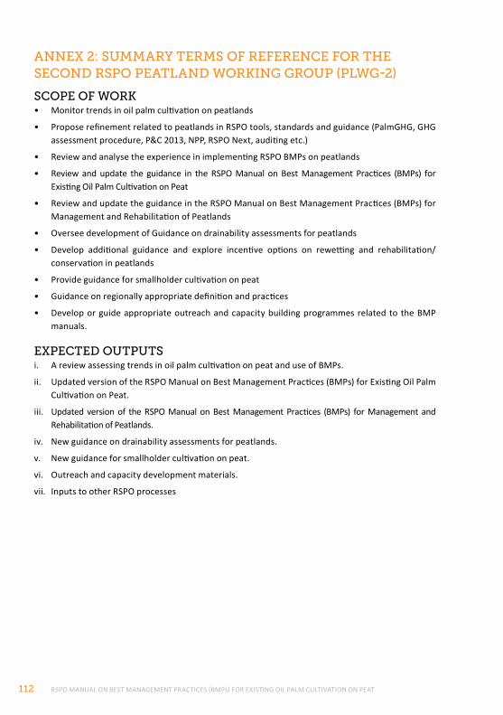
RSPO MANUAL ON BEST MANAGEMENT PRACTICES (BMPs) FOR EXISTING OIL PALM CULTIVATION ON PEAT112
AnneX 2: SummArY termS of reference for the Second rSpo peAtlAnd workIng group (plwg-2)
Scope of work• Monitor trends in oil palm cultivation on peatlands
• Propose refinement related to peatlands in RSPO tools, standards and guidance (PalmGHG, GHG assessment procedure, P&C 2013, NPP, RSPO Next, auditing etc.)
• Review and analyse the experience in implementing RSPO BMPs on peatlands
• Review and update the guidance in the RSPO Manual on Best Management Practices (BMPs) for Existing Oil Palm Cultivation on Peat
• Review and update the guidance in the RSPO Manual on Best Management Practices (BMPs) for Management and Rehabilitation of Peatlands
• Oversee development of Guidance on drainability assessments for peatlands
• Develop additional guidance and explore incentive options on rewetting and rehabilitation/ conservation in peatlands
• Provide guidance for smallholder cultivation on peat
• Guidance on regionally appropriate definition and practices
• Develop or guide appropriate outreach and capacity building programmes related to the BMP manuals.
eXpected outputSi. A review assessing trends in oil palm cultivation on peat and use of BMPs.
ii. Updated version of the RSPO Manual on Best Management Practices (BMPs) for Existing Oil Palm Cultivation on Peat.
iii. Updated version of the RSPO Manual on Best Management Practices (BMPs) for Management and Rehabilitation of Peatlands.
iv. New guidance on drainability assessments for peatlands.
v. New guidance for smallholder cultivation on peat.
vi. Outreach and capacity development materials.
vii. Inputs to other RSPO processes
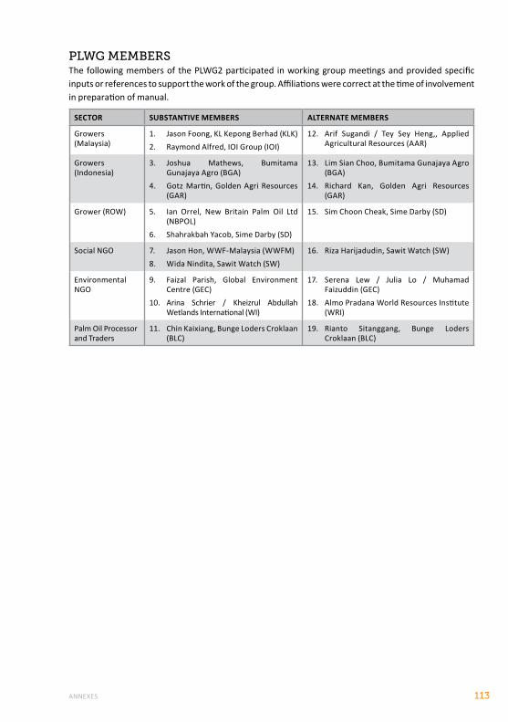
ANNEXES 113
plwg memBerSThe following members of the PLWG2 participated in working group meetings and provided specific inputs or references to support the work of the group. Affiliations were correct at the time of involvement in preparation of manual.
SECTOR SUBSTANTIVE MEMBERS ALTERNATE MEMBERS
Growers (Malaysia)
1. Jason Foong, KL Kepong Berhad (KLK)2. Raymond Alfred, IOI Group (IOI)
12. Arif Sugandi / Tey Sey Heng,, Applied Agricultural Resources (AAR)
Growers (Indonesia)
3. Joshua Mathews, Bumitama Gunajaya Agro (BGA)
4. Gotz Martin, Golden Agri Resources (GAR)
13. Lim Sian Choo, Bumitama Gunajaya Agro (BGA)
14. Richard Kan, Golden Agri Resources (GAR)
Grower (ROW) 5. Ian Orrel, New Britain Palm Oil Ltd (NBPOL)
6. Shahrakbah Yacob, Sime Darby (SD)
15. Sim Choon Cheak, Sime Darby (SD)
Social NGO 7. Jason Hon, WWF-Malaysia (WWFM)8. Wida Nindita, Sawit Watch (SW)
16. Riza Harijadudin, Sawit Watch (SW)
Environmental NGO
9. Faizal Parish, Global Environment Centre (GEC)
10. Arina Schrier / Kheizrul Abdullah Wetlands International (WI)
17. Serena Lew / Julia Lo / Muhamad Faizuddin (GEC)
18. Almo Pradana World Resources Institute (WRI)
Palm Oil Processor and Traders
11. Chin Kaixiang, Bunge Loders Croklaan (BLC)
19. Rianto Sitanggang, Bunge Loders Croklaan (BLC)
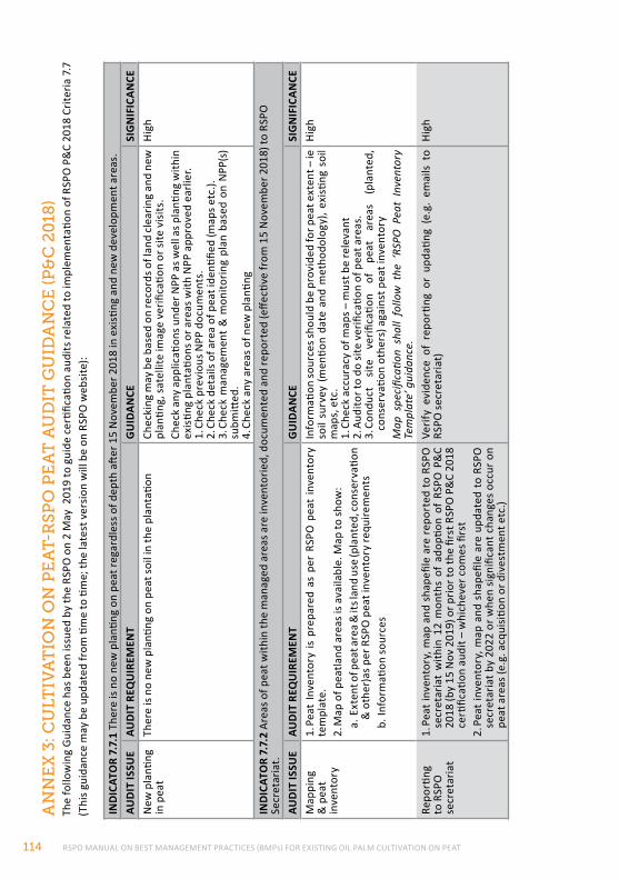
RSPO MANUAL ON BEST MANAGEMENT PRACTICES (BMPs) FOR EXISTING OIL PALM CULTIVATION ON PEAT114
An
ne
X 3
: cu
ltIv
At
Ion
on
pe
At-
rS
po
pe
At
Au
dIt
gu
IdA
nc
e (p
&c
20
18)
The
follo
win
g G
uida
nce
has b
een
issu
ed b
y th
e RS
PO o
n 2
May
201
9 to
gui
de c
ertifi
catio
n au
dits
rela
ted
to im
plem
enta
tion
of R
SPO
P&
C 20
18 C
riter
ia 7
.7
(Thi
s gui
danc
e m
ay b
e up
date
d fr
om ti
me
to ti
me;
the
late
st v
ersi
on w
ill b
e on
RSP
O w
ebsi
te):
IND
ICAT
OR
7.7.
1 Th
ere
is no
new
pla
nting
on
peat
rega
rdle
ss o
f dep
th a
fter 1
5 N
ovem
ber 2
018
in e
xisti
ng a
nd n
ew d
evel
opm
ent a
reas
.AU
DIT
ISSU
EAU
DIT
REQ
UIR
EMEN
TG
UID
ANCE
SIG
NIF
ICAN
CEN
ew p
lanti
ng
in p
eat
Ther
e is
no n
ew p
lanti
ng o
n pe
at s
oil i
n th
e pl
anta
tion
Chec
king
may
be
base
d on
reco
rds o
f lan
d cl
earin
g an
d ne
w
plan
ting,
sat
ellit
e im
age
verifi
catio
n or
site
vis
its.
Chec
k an
y ap
plic
ation
s und
er N
PP a
s wel
l as p
lanti
ng w
ithin
ex
istin
g pl
anta
tions
or a
reas
with
NPP
app
rove
d ea
rlier
.1.
Che
ck p
revi
ous N
PP d
ocum
ents
.2.
Che
ck d
etai
ls of
are
a of
pea
t ide
ntifie
d (m
aps e
tc.).
3. C
heck
man
agem
ent
& m
onito
ring
plan
bas
ed o
n N
PP(s
) su
bmitt
ed.
4. C
heck
any
are
as o
f new
pla
nting
High
IND
ICAT
OR
7.7.
2 Ar
eas o
f pea
t with
in th
e m
anag
ed a
reas
are
inve
ntor
ied,
doc
umen
ted
and
repo
rted
(effe
ctive
from
15
Nov
embe
r 201
8) to
RSP
O
Secr
etar
iat.
AUD
IT IS
SUE
AUD
IT R
EQU
IREM
ENT
GU
IDAN
CESI
GN
IFIC
ANCE
Map
ping
&
pea
t in
vent
ory
1. P
eat
Inve
ntor
y is
prep
ared
as
per
RSPO
pea
t in
vent
ory
tem
plat
e.2.
Map
of p
eatla
nd a
reas
is a
vaila
ble.
Map
to sh
ow:
a. E
xten
t of p
eat a
rea
& it
s lan
d us
e (p
lant
ed, c
onse
rvati
on
& o
ther
)as p
er R
SPO
pea
t inv
ento
ry re
quire
men
tsb.
Info
rmati
on s
ourc
es
Info
rmati
on so
urce
s sho
uld
be p
rovi
ded
for p
eat e
xten
t – ie
so
il su
rvey
(men
tion
date
and
met
hodo
logy
), ex
istin
g so
il m
aps,
etc
.1.
Che
ck a
ccur
acy
of m
aps –
mus
t be
rele
vant
2. A
udito
r to
do si
te v
erifi
catio
n of
pea
t are
as.
3. C
ondu
ct
site
ve
rifica
tion
of
peat
ar
eas
(pla
nted
, co
nser
vatio
n ot
hers
) aga
inst
pea
t inv
ento
ryM
ap s
peci
ficati
on s
hall
follo
w t
he ‘
RSPO
Pea
t In
vent
ory
Tem
plat
e’ g
uida
nce.
High
Repo
rting
to
RSP
O
secr
etar
iat
1. P
eat i
nven
tory
, map
and
sha
pefil
e ar
e re
port
ed to
RSP
O
secr
etar
iat
with
in 1
2 m
onth
s of
ado
ption
of
RSPO
P&
C 20
18 (b
y 15
Nov
201
9) o
r prio
r to
the
first
RSP
O P
&C
2018
ce
rtific
ation
aud
it –
whi
chev
er c
omes
firs
t2.
Pea
t in
vent
ory,
map
and
sha
pefil
e ar
e up
date
d to
RSP
O
secr
etar
iat b
y 20
22 o
r whe
n si
gnifi
cant
cha
nges
occ
ur o
n pe
at a
reas
(e.g
. acq
uisi
tion
or d
ives
tmen
t etc
.)
Verif
y ev
iden
ce o
f re
porti
ng o
r up
datin
g (e
.g.
emai
ls to
RS
PO se
cret
aria
t)Hi
gh
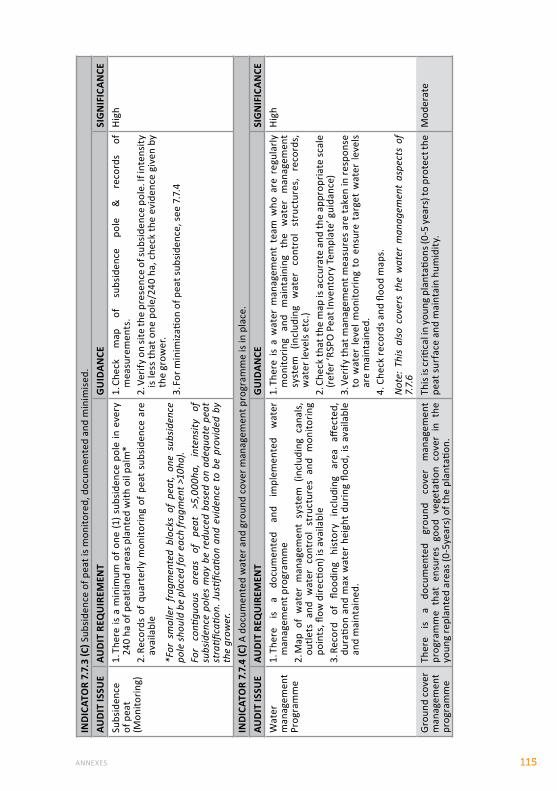
ANNEXES 115
IND
ICAT
OR
7.7.
3 (C
) Sub
side
nce
of p
eat i
s mon
itore
d, d
ocum
ente
d an
d m
inim
ised
.AU
DIT
ISSU
EAU
DIT
REQ
UIR
EMEN
TG
UID
ANCE
SIG
NIF
ICAN
CESu
bsid
ence
of
pea
t (M
onito
ring)
1. Th
ere
is a
min
imum
of o
ne (1
) sub
side
nce
pole
in e
very
24
0 ha
of p
eatla
nd a
reas
pla
nted
with
oil
palm
*2.
Rec
ords
of q
uart
erly
mon
itorin
g of
pea
t su
bsid
ence
are
av
aila
ble
*For
sm
alle
r fr
agm
ente
d bl
ocks
of
peat
, on
e su
bsid
ence
po
le sh
ould
be
plac
ed fo
r eac
h fr
agm
ent >
10ha
).Fo
r co
ntigu
ous
area
s of
pe
at
>5,0
00ha
, in
tens
ity
of
subs
iden
ce p
oles
may
be
redu
ced
base
d on
ade
quat
e pe
at
stra
tifica
tion.
Jus
tifica
tion
and
evid
ence
to
be p
rovi
ded
by
the
grow
er.
1. C
heck
m
ap
of
subs
iden
ce
pole
&
re
cord
s of
m
easu
rem
ents
.2.
Ver
ify o
n si
te th
e pr
esen
ce o
f sub
side
nce
pole
. If i
nten
sity
is
less
that
one
pol
e/24
0 ha
, che
ck th
e ev
iden
ce g
iven
by
the
grow
er.
3. Fo
r min
imiz
ation
of p
eat s
ubsi
denc
e, se
e 7.
7.4
High
IND
ICAT
OR
7.7.
4 (C
) A d
ocum
ente
d w
ater
and
gro
und
cove
r man
agem
ent p
rogr
amm
e is
in p
lace
.AU
DIT
ISSU
EAU
DIT
REQ
UIR
EMEN
TG
UID
ANCE
SIG
NIF
ICAN
CEW
ater
m
anag
emen
t Pr
ogra
mm
e
1. Th
ere
is a
docu
men
ted
and
impl
emen
ted
wat
er
man
agem
ent p
rogr
amm
e2.
Map
of
wat
er m
anag
emen
t sy
stem
(in
clud
ing
cana
ls,
outle
ts a
nd w
ater
con
trol
str
uctu
res
and
mon
itorin
g po
ints
, flow
dire
ction
) is a
vaila
ble
3. R
ecor
d of
flo
odin
g hi
stor
y in
clud
ing
area
aff
ecte
d,
dura
tion
and
max
wat
er h
eigh
t du
ring
flood
, is
avai
labl
e an
d m
aint
aine
d.
1. Th
ere
is a
wat
er m
anag
emen
t te
am w
ho a
re r
egul
arly
m
onito
ring
and
mai
ntai
ning
th
e w
ater
m
anag
emen
t sy
stem
(in
clud
ing
wat
er
cont
rol
stru
ctur
es,
reco
rds,
w
ater
leve
ls et
c.)
2. C
heck
that
the
map
is a
ccur
ate
and
the
appr
opria
te sc
ale
(ref
er ‘R
SPO
Pea
t Inv
ento
ry T
empl
ate’
gui
danc
e)3.
Ver
ify th
at m
anag
emen
t mea
sure
s ar
e ta
ken
in re
spon
se
to w
ater
leve
l mon
itorin
g to
ens
ure
targ
et w
ater
leve
ls ar
e m
aint
aine
d.4.
Che
ck re
cord
s and
floo
d m
aps.
Not
e: T
his
also
cov
ers
the
wat
er m
anag
emen
t as
pect
s of
7.
7.6
High
Gro
und
cove
r m
anag
emen
t pr
ogra
mm
e
Ther
e is
a do
cum
ente
d gr
ound
co
ver
man
agem
ent
prog
ram
me
that
ens
ures
goo
d ve
geta
tion
cove
r in
the
yo
ung
repl
ante
d ar
eas (
0-5y
ears
) of t
he p
lant
ation
.
This
is cr
itica
l in
youn
g pl
anta
tions
(0-5
yea
rs) t
o pr
otec
t the
pe
at su
rfac
e an
d m
aint
ain
hum
idity
.M
oder
ate
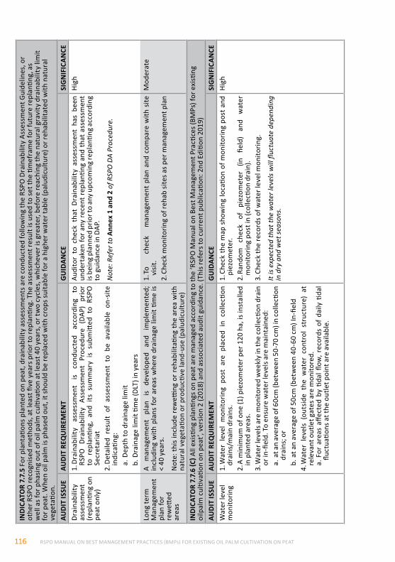
RSPO MANUAL ON BEST MANAGEMENT PRACTICES (BMPs) FOR EXISTING OIL PALM CULTIVATION ON PEAT116
IND
ICAT
OR
7.7.
5 Fo
r pla
ntati
ons p
lant
ed o
n pe
at, d
rain
abili
ty a
sses
smen
ts a
re c
ondu
cted
follo
win
g th
e RS
PO D
rain
abili
ty A
sses
smen
t Gui
delin
es, o
r ot
her R
SPO
reco
gnis
ed m
etho
ds, a
t lea
st fi
ve y
ears
prio
r to
repl
antin
g. T
he a
sses
smen
t res
ult i
s use
d to
set t
he ti
mef
ram
e fo
r fut
ure
repl
antin
g, a
s w
ell a
s for
pha
sing
out
of o
il pa
lm c
ultiv
ation
at l
east
40
year
s, o
r tw
o cy
cles
, whi
chev
er is
gre
ater
, bef
ore
reac
hing
the
natu
ral g
ravi
ty d
rain
abili
ty li
mit
for p
eat.
Whe
n oi
l pal
m is
pha
sed
out,
it sh
ould
be
repl
aced
with
cro
ps su
itabl
e fo
r a h
ighe
r wat
er ta
ble
(pal
udic
ultu
re) o
r reh
abili
tate
d w
ith n
atur
al
vege
tatio
n.AU
DIT
ISSU
EAU
DIT
REQ
UIR
EMEN
TG
UID
ANCE
SIG
NIF
ICAN
CEDr
aina
bilit
y as
sess
men
t (r
epla
nting
on
peat
onl
y)
1. D
rain
abili
ty
asse
ssm
ent
is co
nduc
ted
acco
rdin
g to
RS
PO D
rain
abili
ty A
sses
smen
t Pr
oced
ure
(DAP
) pr
ior
to r
epla
nting
, an
d its
sum
mar
y is
subm
itted
to
RSPO
Se
cret
aria
t2.
Det
aile
d re
sult
of a
sses
smen
t to
be
avai
labl
e on
-site
in
dica
ting:
a. D
epth
to d
rain
age
limit
b. D
rain
age
limit
time
(DLT
) in
year
s
Audi
tor
to c
heck
tha
t D
rain
abili
ty a
sses
smen
t ha
s be
en
unde
rtak
en fo
r any
rec
ent r
epla
nting
and
that
ass
essm
ent
is be
ing
plan
ned
prio
r to
any u
pcom
ing
repl
antin
g ac
cord
ing
to g
uida
nce
in D
AP.
Not
e: R
efer
to A
nnex
1 a
nd 2
of R
SPO
DA
Proc
edur
e.
High
Long
term
M
anag
emen
t pl
an fo
r re
wett
ed
area
s
A m
anag
emen
t pl
an
is de
velo
ped
and
impl
emen
ted;
in
clud
ing
with
pla
ns fo
r ar
eas
whe
re d
rain
age
limit
time
is <
40 y
ears
.
Not
e: th
is in
clud
e re
wetti
ng o
r reh
abili
tatin
g th
e ar
ea w
ith
natu
ral v
eget
ation
or p
rodu
ctive
land
-use
(pal
udic
ultu
re)
1. To
ch
eck
man
agem
ent
plan
and
com
pare
with
site
vi
sit.
2. C
heck
mon
itorin
g of
reha
b si
tes a
s per
man
agem
ent p
lan
Mod
erat
e
IND
ICAT
OR
7.7.
6 (C
) All
exis
ting
plan
tings
on
peat
are
man
aged
acc
ordi
ng to
the
‘RSP
O M
anua
l on
Best
Man
agem
ent P
racti
ces (
BMPs
) for
exi
sting
oi
lpal
m c
ultiv
ation
on
peat
’, ve
rsio
n 2
(201
8) a
nd a
ssoc
iate
d au
dit g
uida
nce.
(Thi
s ref
ers t
o cu
rren
t pub
licati
on: 2
nd E
ditio
n 20
19)
AUD
IT IS
SUE
AUD
IT R
EQU
IREM
ENT
GU
IDAN
CESI
GN
IFIC
ANCE
Wat
er le
vel
mon
itorin
g1.
Wat
er l
evel
mon
itorin
g po
st a
re p
lace
d in
col
lecti
on
drai
ns/m
ain
drai
ns.
2. A
min
imum
of o
ne (1
) pie
zom
eter
per
120
ha,
is in
stal
led
in p
lant
ed a
reas
.3.
Wat
er le
vels
are
mon
itore
d w
eekl
y in
the
colle
ction
dra
in
or in
-fiel
d. T
o en
sure
wat
er le
vels
are
mai
ntai
ned:
a. a
t an
aver
age
of 6
0cm
(bet
wee
n 50
-70
cm) i
n co
llecti
on
drai
ns; o
rb.
at a
n av
erag
e of
50c
m (b
etw
een
40-6
0 cm
) In-
field
4. W
ater
lev
els
(out
side
the
wat
er c
ontr
ol s
truc
ture
) at
re
leva
nt o
utle
t gat
es a
re m
onito
red.
a. F
or a
reas
affe
cted
by
tidal
flow
, rec
ords
of
daily
tida
l flu
ctua
tions
at t
he o
utle
t poi
nt a
re a
vaila
ble.
1. C
heck
the
map
sho
win
g lo
catio
n of
mon
itorin
g po
st a
nd
piez
omet
er.
2. R
ando
m
chec
k of
pi
ezom
eter
(in
fie
ld)
and
wat
er
mon
itorin
g po
st in
(col
lecti
on d
rain
).3.
Che
ck th
e re
cord
s of w
ater
leve
l mon
itorin
g.
It is
expe
cted
that
the
wat
er le
vels
will
fluc
tuat
e de
pend
ing
in d
ry a
nd w
et se
ason
s.
High
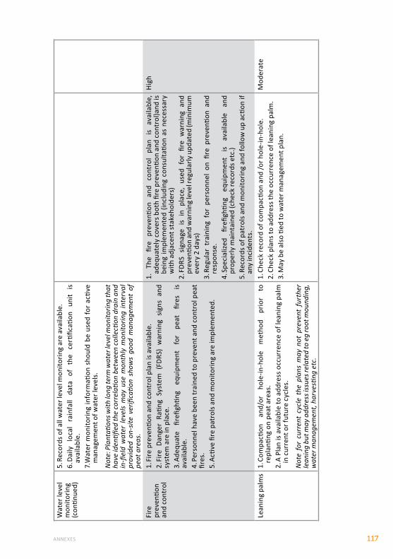
ANNEXES 117
Wat
er le
vel
mon
itorin
g (c
ontin
ued)
5. R
ecor
ds o
f all
wat
er le
vel m
onito
ring
are
avai
labl
e.6.
Dai
ly
loca
l ra
infa
ll da
ta
of
the
certi
ficati
on
unit
is av
aila
ble.
7. W
ater
mon
itorin
g in
form
ation
sho
uld
be u
sed
for
activ
e m
anag
emen
t of w
ater
leve
ls.
Not
e: P
lant
ation
s with
long
term
wat
er le
vel m
onito
ring
that
ha
ve id
entifi
ed th
e co
rrel
ation
bet
wee
n co
llecti
on d
rain
and
in
-fiel
d w
ater
leve
ls m
ay u
se m
onth
ly m
onito
ring
inte
rval
pr
ovid
ed o
n-sit
e ve
rifica
tion
show
s go
od m
anag
emen
t of
pe
at a
reas
.Fi
re
prev
entio
n an
d co
ntro
l
1. Fi
re p
reve
ntion
and
con
trol
pla
n is
avai
labl
e.2.
Fire
Dan
ger
Ratin
g Sy
stem
(FD
RS)
war
ning
sig
ns a
nd
syst
em a
re in
pla
ce.
3. A
dequ
ate
firefi
ghtin
g eq
uipm
ent
for
peat
fir
es
is av
aila
ble.
4. P
erso
nnel
hav
e be
en tr
aine
d to
pre
vent
and
con
trol
pea
t fir
es.
5. A
ctive
fire
pat
rols
and
mon
itorin
g ar
e im
plem
ente
d.
1.
The
fire
prev
entio
n an
d co
ntro
l pl
an
is av
aila
ble,
ad
equa
tely
cov
ers b
oth
fire
prev
entio
n an
d co
ntro
l)and
is
bein
g im
plem
ente
d (in
clud
ing
cons
ulta
tion
as n
eces
sary
w
ith a
djac
ent s
take
hold
ers)
2. FD
RS s
igna
ge i
s in
pla
ce,
used
for
fire
war
ning
and
pr
even
tion
and
war
ning
leve
l reg
ular
ly u
pdat
ed (m
inim
um
ever
y 2
days
)3.
Reg
ular
tra
inin
g fo
r pe
rson
nel
on fi
re p
reve
ntion
and
re
spon
se.
4. Sp
ecia
lized
fir
efigh
ting
equi
pmen
t is
avai
labl
e an
d pr
oper
ly m
aint
aine
d (c
heck
reco
rds e
tc.)
5. R
ecor
ds o
f pat
rols
and
mon
itorin
g an
d fo
llow
up
actio
n if
any
inci
dent
s.
High
Lean
ing
palm
s1.
Com
pacti
on
and/
or
hole
-in-h
ole
met
hod
prio
r to
re
plan
ting
on p
eat a
reas
.2.
A P
lan
is av
aila
ble
to a
ddre
ss o
ccur
renc
e of
lean
ing
palm
in
cur
rent
or f
utur
e cy
cles
.
Not
e fo
r cu
rren
t cy
cle
the
plan
s m
ay n
ot p
reve
nt f
urth
er
lean
ing
but m
ay a
ddre
ss is
sues
rela
ted
to e
g ro
ot m
ound
ing,
w
ater
man
agem
ent,
harv
estin
g et
c.
1. C
heck
reco
rd o
f com
pacti
on a
nd /o
r hol
e-in
-hol
e.2.
Che
ck p
lans
to a
ddre
ss th
e oc
curr
ence
of l
eani
ng p
alm
.3.
May
be
also
tied
to w
ater
man
agem
ent p
lan.
Mod
erat
e
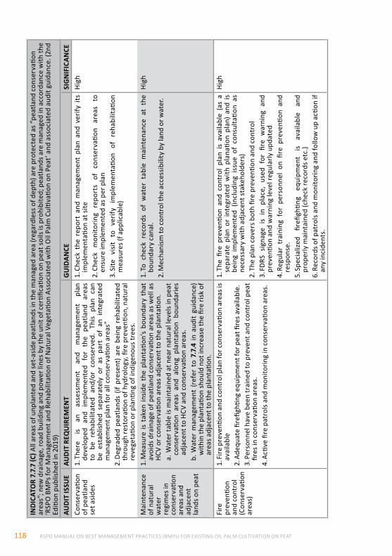
RSPO MANUAL ON BEST MANAGEMENT PRACTICES (BMPs) FOR EXISTING OIL PALM CULTIVATION ON PEAT118
IND
ICAT
OR
7.7.
7 (C
) All
area
s of u
npla
nted
and
set-
asid
e pe
atla
nds i
n th
e m
anag
ed a
rea
(reg
ardl
ess o
f dep
th) a
re p
rote
cted
as “
peat
land
con
serv
ation
ar
eas”
; new
dra
inag
e, ro
ad b
uild
ing
and
pow
er li
nes b
y th
e un
it of
cer
tifica
tion
on p
eat s
oils
is pr
ohib
ited;
pea
tland
s are
man
aged
in a
ccor
danc
e w
ith th
e ‘R
SPO
BM
Ps fo
r Man
agem
ent a
nd R
ehab
ilita
tion
of N
atur
al V
eget
ation
Ass
ocia
ted
with
Oil
Palm
Cul
tivati
on o
n Pe
at’ a
nd a
ssoc
iate
d au
dit g
uida
nce.
(2nd
Ed
ition
pub
lishe
d in
201
9)AU
DIT
ISSU
EAU
DIT
REQ
UIR
EMEN
TG
UID
ANCE
SIG
NIF
ICAN
CECo
nser
vatio
n of
pea
tland
se
t asi
des
1. Th
ere
is an
as
sess
men
t an
d m
anag
emen
t pl
an
deve
lope
d an
d im
plem
ente
d fo
r th
e pe
atla
nd a
reas
to
be
reha
bilit
ated
and
/or
cons
erve
d. T
his
plan
can
be
est
ablis
hed
sepa
rate
ly o
r as
par
t of
an
inte
grat
ed
man
agem
ent p
lan
for a
ll co
nser
vatio
n ar
eas”
2. D
egra
ded
peat
land
s (if
pre
sent
) ar
e be
ing
reha
bilit
ated
th
roug
h re
stor
ation
of h
ydro
logy
, fire
pre
venti
on, n
atur
al
reve
geta
tion
or p
lanti
ng o
f ind
igen
ous t
rees
.
1. C
heck
the
rep
ort
and
man
agem
ent
plan
and
ver
ify i
ts
impl
emen
tatio
n at
site
2. C
heck
m
onito
ring
repo
rts
of
cons
erva
tion
area
s to
en
sure
impl
emen
ted
as p
er p
lan
3. Si
te
visi
t to
ve
rify
impl
emen
tatio
n of
re
habi
litati
on
mea
sure
s (f a
pplic
able
)
High
Mai
nten
ance
of
nat
ural
w
ater
re
gim
es in
co
nser
vatio
n ar
eas a
nd
adja
cent
la
nds o
n pe
at
1. M
easu
re is
tak
en in
side
the
pla
ntati
on’s
boun
dary
tha
t av
oids
dra
inag
e of
pea
tland
con
serv
ation
are
as a
s wel
l as
HCV
or c
onse
rvati
on a
reas
adj
acen
t to
the
plan
tatio
n.a.
Wat
er ta
ble
is m
aint
aine
d at
nea
r nat
ural
leve
ls in
pea
t co
nser
vatio
n ar
eas
and
alon
g pl
anta
tion
boun
darie
s ad
jace
nt to
HCV
and
con
serv
ation
are
as.
b. W
ater
man
agem
ent
(ref
er t
o 7.
7.4
in a
udit
guid
ance
) w
ithin
the
plan
tatio
n sh
ould
not
incr
ease
the
fire
risk
of
area
s adj
acen
t to
the
plan
tatio
n.
1. To
che
ck r
ecor
ds o
f w
ater
tab
le m
aint
enan
ce a
t th
e bo
unda
ry c
anal
.2.
Mec
hani
sm to
con
trol
the
acce
ssib
ility
by
land
or w
ater
.
High
Fire
pr
even
tion
and
cont
rol
(Con
serv
ation
ar
eas)
1. Fi
re p
reve
ntion
and
con
trol
pla
n fo
r con
serv
ation
are
as is
av
aila
ble
2. A
dequ
ate
firefi
ghtin
g eq
uipm
ent f
or p
eat fi
res a
vaila
ble.
3. P
erso
nnel
hav
e be
en tr
aine
d to
pre
vent
and
con
trol
pea
t fir
es in
con
serv
ation
are
as.
4. A
ctive
fire
pat
rols
and
mon
itorin
g in
con
serv
ation
are
as.
1. Th
e fir
e pr
even
tion
and
cont
rol
plan
is
avai
labl
e (a
s a
sepa
rate
pla
n or
inte
grat
ed w
ith p
lana
tion
plan
) an
d is
bein
g im
plem
ente
d (in
clud
ing
issu
e of
con
sulta
tion
as
nece
ssar
y w
ith a
djac
ent s
take
hold
ers)
2. Th
e pl
an c
over
s bot
h fir
e pr
even
tion
and
cont
rol
3. FD
RS s
igna
ge i
s in
pla
ce,
used
for
fire
war
ning
and
pr
even
tion
and
war
ning
leve
l reg
ular
ly u
pdat
ed4.
Reg
ular
tra
inin
g fo
r pe
rson
nel
on fi
re p
reve
ntion
and
re
spon
se.
5. Sp
ecia
lized
fir
efigh
ting
equi
pmen
t is
avai
labl
e an
d pr
oper
ly m
aint
aine
d (c
heck
reco
rds e
tc.)
6. R
ecor
ds o
f pat
rols
and
mon
itorin
g an
d fo
llow
up
actio
n if
any
inci
dent
s.
High
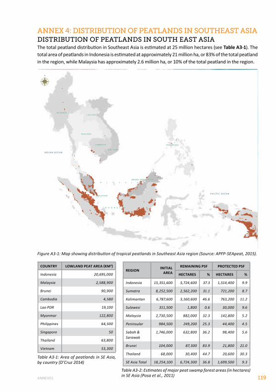
ANNEXES 119
AnneX 4: dIStrIButIon of peAtlAndS In SoutheASt ASIAdIStrIButIon of peAtlAndS In South eASt ASIAThe total peatland distribution in Southeast Asia is estimated at 25 million hectares (see Table A3-1). The total area of peatlands in Indonesia is estimated at approximately 21 million ha, or 83% of the total peatland in the region, while Malaysia has approximately 2.6 million ha, or 10% of the total peatland in the region.
Figure A3-1: Map showing distribution of tropical peatlands in Southeast Asia region (Source: APFP-SEApeat, 2015).
COUNTRy LOWLAND PEAT AREA (KM2)
Indonesia 20,695,000
Malaysia 2,588,900
Brunei 90,900
Cambodia 4,580
Lao PDR 19,100
Myanmar 122,800
Philippines 64,500
Singapore 50
Thailand 63,800
Vietnam 53,300
REGION INITIAL AREA
REMAINING PSF PROTECTED PSF
HECTARES % HECTARES %
Indonesia 15,351,600 5,724,600 37.3 1,514,400 9.9
Sumatra 8,252,500 2,562,200 31.1 721,200 8.7
Kalimantan 6,787,600 3,160,600 46.6 763,200 11.2
Sulawesi 311,500 1,800 0.6 30,000 9.6
Malaysia 2,730,500 882,000 32.3 142,800 5.2
Peninsular 984,500 249,200 25.3 44,400 4.5
Sabah & Sarawak
1,746,000 632,800 36.2 98,400 5.6
Brunei 104,000 87,300 83.9 21,800 21.0
Thailand 68,000 30,400 44.7 20,600 30.3
SE Asia Total 18,254,100 6,724,300 36.8 1,699,500 9.3Table A3-1: Area of peatlands in SE Asia, by country (D’Cruz 2014)
Table A3-2: Estimates of major peat swamp forest areas (in hectares) in SE Asia (Posa et al., 2011)
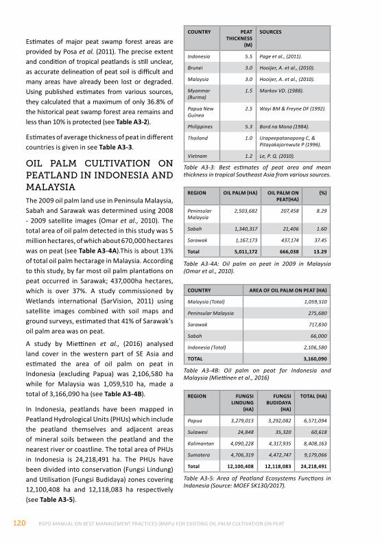
RSPO MANUAL ON BEST MANAGEMENT PRACTICES (BMPs) FOR EXISTING OIL PALM CULTIVATION ON PEAT120
Estimates of major peat swamp forest areas are provided by Posa et al. (2011). The precise extent and condition of tropical peatlands is still unclear, as accurate delineation of peat soil is difficult and many areas have already been lost or degraded. Using published estimates from various sources, they calculated that a maximum of only 36.8% of the historical peat swamp forest area remains and less than 10% is protected (see Table A3-2).
Estimates of average thickness of peat in different countries is given in see Table A3-3.
oIl pAlm cultIvAtIon on peAtlAnd In IndoneSIA And mAlAYSIAThe 2009 oil palm land use in Peninsula Malaysia, Sabah and Sarawak was determined using 2008 - 2009 satellite images (Omar et al., 2010). The total area of oil palm detected in this study was 5 million hectares, of which about 670,000 hectares was on peat (see Table A3-4A).This is about 13% of total oil palm hectarage in Malaysia. According to this study, by far most oil palm plantations on peat occurred in Sarawak; 437,000ha hectares, which is over 37%. A study commissioned by Wetlands international (SarVision, 2011) using satellite images combined with soil maps and ground surveys, estimated that 41% of Sarawak’s oil palm area was on peat.
A study by Miettinen et al., (2016) analysed land cover in the western part of SE Asia and estimated the area of oil palm on peat in Indonesia (excluding Papua) was 2,106,580 ha while for Malaysia was 1,059,510 ha, made a total of 3,166,090 ha (see Table A3-4B).
In Indonesia, peatlands have been mapped in Peatland Hydrological Units (PHUs) which include the peatland themselves and adjacent areas of mineral soils between the peatland and the nearest river or coastline. The total area of PHUs in Indonesia is 24,218,491 ha. The PHUs have been divided into conservation (Fungsi Lindung) and Utilisation (Fungsi Budidaya) zones covering 12,100,408 ha and 12,118,083 ha respectively (see Table A3-5).
COUNTRy PEAT THICKNESS
(M)
SOURCES
Indonesia 5.5 Page et al., (2011).
Brunei 3.0 Hooijer, A. et al., (2010).
Malaysia 3.0 Hooijer, A. et al., (2010).
Myanmar (Burma)
1.5 Markov VD. (1988).
Papua New Guinea
2.5 Wayi BM & Freyne DF (1992).
Philippines 5.3 Bord na Mona (1984).
Thailand 1.0 Urapeepatanapong C, & Pitayakajornwute P (1996).
Vietnam 1.2 Le, P. Q. (2010).
COUNTRy AREA OF OIL PALM ON PEAT (HA)
Malaysia (Total) 1,059,510
Peninsular Malaysia 275,680
Sarawak 717,830
Sabah 66,000
Indonesia (Total) 2,106,580
TOTAL 3,160,090
Table A3-3: Best estimates of peat area and mean thickness in tropical Southeast Asia from various sources.
Table A3-4A: Oil palm on peat in 2009 in Malaysia (Omar et al., 2010).
Table A3-4B: Oil palm on peat for Indonesia and Malaysia (Miettinen et al., 2016)
Table A3-5: Area of Peatland Ecosystems Functions in Indonesia (Source: MOEF SK130/2017).
REGION FUNGSI LINDUNG
(HA)
FUNGSI BUDIDAyA
(HA)
TOTAL (HA)
Papua 3,279,013 3,292,082 6,571,094
Sulawesi 24,848 35,320 60,618
Kalimantan 4,090,228 4,317,935 8,408,163
Sumatera 4,706,319 4,472,747 9,179,066
Total 12,100,408 12,118,083 24,218,491
REGION OIL PALM (HA) OIL PALM ON PEAT(HA)
(%)
Peninsular Malaysia
2,503,682 207,458 8.29
Sabah 1,340,317 21,406 1.60
Sarawak 1,167,173 437,174 37.45
Total 5,011,172 666,038 13.29
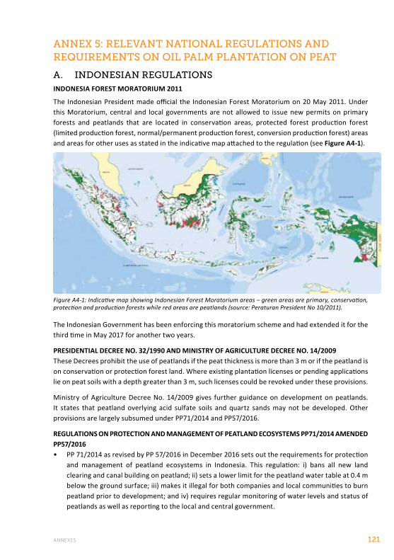
ANNEXES 121
AnneX 5: relevAnt nAtIonAl regulAtIonS And reQuIrementS on oIl pAlm plAntAtIon on peAt
A. IndoneSIAn regulAtIonSINDONESIA FOREST MORATORIUM 2011
The Indonesian President made official the Indonesian Forest Moratorium on 20 May 2011. Under this Moratorium, central and local governments are not allowed to issue new permits on primary forests and peatlands that are located in conservation areas, protected forest production forest (limited production forest, normal/permanent production forest, conversion production forest) areas and areas for other uses as stated in the indicative map attached to the regulation (see Figure A4-1).
The Indonesian Government has been enforcing this moratorium scheme and had extended it for the third time in May 2017 for another two years.
PRESIDENTIAL DECREE NO. 32/1990 AND MINISTRY OF AGRICULTURE DECREE NO. 14/2009These Decrees prohibit the use of peatlands if the peat thickness is more than 3 m or if the peatland is on conservation or protection forest land. Where existing plantation licenses or pending applications lie on peat soils with a depth greater than 3 m, such licenses could be revoked under these provisions.
Ministry of Agriculture Decree No. 14/2009 gives further guidance on development on peatlands. It states that peatland overlying acid sulfate soils and quartz sands may not be developed. Other provisions are largely subsumed under PP71/2014 and PP57/2016.
REGULATIONS ON PROTECTION AND MANAGEMENT OF PEATLAND ECOSYSTEMS PP71/2014 AMENDED PP57/2016• PP 71/2014 as revised by PP 57/2016 in December 2016 sets out the requirements for protection
and management of peatland ecosystems in Indonesia. This regulation: i) bans all new land clearing and canal building on peatland; ii) sets a lower limit for the peatland water table at 0.4 m below the ground surface; iii) makes it illegal for both companies and local communities to burn peatland prior to development; and iv) requires regular monitoring of water levels and status of peatlands as well as reporting to the local and central government.
Figure A4-1: Indicative map showing Indonesian Forest Moratorium areas – green areas are primary, conservation, protection and production forests while red areas are peatlands (source: Peraturan President No 10/2011).
RSPO MANUAL ON BEST MANAGEMENT PRACTICES (BMPs) FOR EXISTING OIL PALM CULTIVATION ON PEAT122
• With the issuance of PP 57/2016, Indonesian peatlands have been subdivided into more than 300 Peatland Hydrological Units (PHUs). At least 30% of each PHU must be conserved including areas of remaining quality peat swamp forests, and all peatland areas more than 3m deep. This means that a company operating in a peatland may be obliged to set aside an area for conservation (Chapter 9, Clause3, 4(a)). Detailed maps showing PHUs and areas to be conserved are included in the following sub regulations:
• SK129/2017 on Determination of National Peatland Hydrological Units Map (Keputusan Menteri LHK Nomor SK.129/Menlhk/Setjen/Pkl.0/2/2017 Tentang Penetapan Peta Kesatuan Hodrologis Gambut Nasional)
• SK130/2017 on Determination of Map of National Peatland Ecosystem Functions (Keputusan Menteri Lingkungan Hidup Dan Kehutanan Republik Indonesia Nomor SK.130/Menlhk/Setjen/Pkl.0/2/2017 Tentang Penetapan Peta Fungsi Ekosistem Gambut Nasional)
Further sub regulations detail out the requirements for inventory and mapping, ecosystem function assessment as well as water table monitoring and management as follows:
• Peraturan Menteri Lingkungan Hidup dan Kehutanan Nomor P.14/MENLHK/SETJEN/KUM.1/2/2017 tentang Tata Cara Inventarisasi dan Penetapan Fungsi Ekosistem Gambut (P.14/2017 on Procedure for Inventory and Determination of Peat Ecosystem Functions)
• Peraturan Menteri Lingkungan Hidup dan Kehutanan Nomor P.15/MENLHK/SETJEN/KUM.1/2/2017 tentang Tata Cara Pengukuran Muka Air Tanah di Titik Penaatan Ekosistem Gambut (P.15/2017 on Procedures for Measuring Groundwater Levels in Peat Ecosystem at Designated Monitoring Points)
• Peraturan Menteri Lingkungan Hidup dan Kehutanan Nomor P.16/MENLHK/SETJEN/KUM.1/2/2017 tentang Pedoman Teknis Pemulihan Fungsi Ekosistem Gambut (P.16/2017 on Technical Guidelines for Functions Recovery of Peat Ecosystem)
There was also P.17/2017 on revision of P.12/2015 Development of Industrial Forest Plantations that emphasizes on peat-related matters including definitions and additional requirements to protect/conserve peatland areas within plantation concession.
INDONESIAN SUSTAINABLE PALM OIL (ISPO) REQUIREMENTSUnder the Ministry of Agriculture Decree No. 19/ 2011, the following ISPO Criteria specifically relevant to cultivation of oil palm on peatland are to be implemented:
CRITERION 2.1.5 Plantings on peatland – Planting oil palm on peatlands can be done by observing characteristics of peat so as to not cause damage to environmental functions
• INDICATORS
1. Available SOPs/work instructions for planting on peat soil and refer to the applicable regulations
2. Implementation of crop planting documented
• GUIDANCE
SOPs or work instructions for planting should include:
• Planting is done on peatland with a depth <3 m and the proportion of planting includes 70% of the total acreage; mineral soil layer below the peat is not quartz sand or acid sulfate soil and peat soil is sapric
• Setting the number of palms and planting density in accordance with field conditions and best agricultural practices
• Implementation of cover crops
• Setting high ground water levels between 50-60 cm to inhibit carbon emissions from peatlands
ANNEXES 123
CRITERION 3.6 Mitigation of Greenhouse Gas (GHG) Emissions– Management of the plantation business must identify the source of GHG emissions.
• INDICATORS1. Technical guidance/SOP for GHG
Mitigation available
2. Inventory of GHG emissions sources available
3. Land use trajectory available
4. Records of GHG emission reductions available
5. Records of implementation of mitigation available
• GUIDANCE• Do an inventory of sources of GHG
emissions
• Socialization efforts to reduce GHG emissions (methane capture, water management on peatland, proper fertilization, etc.) and calculation methods
• Utilization of solid wastes (fiber, shells, etc.) as boiler fuel and efficiency calculations of fossil fuel use
• Have evidence of land use at least 2 years prior to land clearing for plantation and evidence of cultivation.
BoX 14eXplAnAtIon of ABBrevIAtIonS uSed In ISpo crIterIAPlantation Business License (IUP) is a written permission from the competent authority and should be owned by companies that do business with integrated plantation production and processing.
Plantation Business Permit for Cultivation (IUP- B) is a written permission from the competent authority and should be owned by a company that does the cultivation of a plantation (it has no processing unit).
Plantation Business License for Processing (IUP- P) is a written permission from the competent authorities and should be owned by a company that does business on plantation production and processing (at least 20% of the raw material must come from owned plantation).
Hak Guna Usaha (HGU) is the right to exploit State-owned land for agriculture, fishery or husbandry purposes for a period of up to 35 years with a possible 25 years extension. It could be renewed on the same land with similar HGU when the permit expires. HGU is given to an area of at least 5 (five) hectares and if it exceeds 25 (twenty five) hectares, it should use decent capital investment and good corporate techniques in accordance with the times.
Hak Guna Bangunan (HGB) is a right to establish and own buildings on land not privately owned with a period of 30 (thirty) years. At the request of rights-holders and keeping in mind the state building construction within this time period may be extended by 20 (twenty) years maximum.
Examination Committee for Soil B, hereinafter referred to Committee B is the committee in charge of ground checks in order to request completion, extension and renewal of HGU. B Committee members consist of various agencies of State and Acting Head of related BPN, local government district/ municipality, Head Plantation Office, Head of Provincial Forestry Office, Head of Department of Animal Husbandry/Fishing, and Acting District Head of related BPN. Committee B’s task is to examine the completeness of the HGU petition, research and review of physical soil, determine suitability for requested business, conduct an audit for HGU land applied for and give an opinion/judgment on the request as outlined in the Minutes of the Land Inspection.
Rights of Use (Hak Pakai) is the right to use State-owned or other land by public or private persons or entities for a definite period or occasionally for an indefinite period. This land right cannot be sold, exchanged or transferred unless explicitly provided in its grant or agreement. This right may be held by an Indonesian individual or entity, certain foreign individuals or a foreign legal entity with a representative office in Indonesia.
RSPO MANUAL ON BEST MANAGEMENT PRACTICES (BMPs) FOR EXISTING OIL PALM CULTIVATION ON PEAT124
B. mAlAYSIAn regulAtIonSMALAYSIAN SUSTAINABLE PALM OIL (MSPO) STANDARDMalaysia government had introduced Malaysian Sustainable Palm Oil (MSPO) Standard in 2013. Implementation of MSPO certification scheme started on voluntary basis and since on 1st January 2015, it became mandatory for both plantations and smallholders to be certified by 31 December 2019 to obtain the MSPO Standard certificate.
MSPO requirements include the following criteria under Principle 7:• New planting and replanting on peatlands can be developed as per MPOB’s guidelines and
industry’s best practices
NATIONAL PHYSICAL PLAN (NPP)The NPP states that Malaysia’s Protected Areas (PA) network shall be enlarged to include a full representation of the diversity of natural ecosystems, particularly the lowland dipterocarp forests and wetlands. It also recommends that there shall be adequate buffer zones between ESA and agriculture development.
NATIONAL ACTION PLAN FOR PEATLANDS (2011-2020)The goal of NAPP is to sustainably manage peatlands in Malaysia in an integrated manner to conserve resources, prevent degradation and fires, and generate benefits for current and future generation. It comprises four objectives:
1. Enhance knowledge, awareness and capacity for sustainable peatlands management and development
2. Conserve peatlands resources and reduce peatland degradation and fires
3. Promote the sustainable and integrated management peatlands
4. Ensure effective multi-stakeholder cooperation
The National Policy on Biological Diversity 2016–2025 provides the direction and framework to conserve biodiversity and use it in sustainable manner. The Federal government via Ministry of Water, Land and Natural Resource (formerly known as Ministry of Natural Resources and Environment) will play a leading role in implementing the Policy. The Policy has five overarching goals encompassing:
1. Stakeholder empowerment
2. Reduced the direct and indirect pressures on biodiversity
3. Safeguarded all key ecosystems, species and genetic diversity
4. Ensured that the benefits from the utilisation of biodiversity are shared equitably
5. Improved the capacity, knowledge and skills of all stakeholders to conserve biodiversity
THE NATIONAL POLICY ON BIOLOGICAL DIVERSITY (2016-2025)
ENVIRONMENTAL IMPACT ASSESSMENTS (EIAS)EIAs are a mandatory requirement for proposed development projects categorized as ‘prescribed activities’. In exercise of the powers conferred by Section 34a of the Environmental Quality Act 1974, the Minister, after consultation with the Environmental Quality Council, makes the following order. The prescribed activities as stated in Environmental Quality (Prescribed Activities) (Environmental Impact Assessment)Order 2015 specified Schedule below (extracted list):
ANNEXES 125
AGRICULTUREFirst Schedulei. Land development schemes covering an area of 20 hectares or more but less than 500
hectares to bring forest land into agricultural production.
ii. Development of agricultural estates covering an area of 500 hectares or more involving changes in types of agricultural use.
Second Schedulei. Land development schemes covering an area of 500 hectares or more to bring forest into
agriculture production
DRAINAGE AND IRRIGATIONFirst Schedulei. Construction of dams and man-made lakes and artificial enlargement of lakes with surface
areas of 100 hectares or more.
ii. Irrigation schemes covering an area of 500 hectares or more.
Second Schedulei. Construction of man-made lakes and artificial enlargement of lakes with surface areas of 50
hectares or more in or adjacent or near to environmentally sensitive area.
ii. Any drainage of wetland, wild-life habitat or dry inland forest covering an area of 20 hectares or more.
STRAPEAT- UNIMAS-NREB (2004) provides the following guidance in terms of EIA compliance for potential peatland development particularly in Sarawak:
KEy ELEMENTS FOR BASELINE STUDy ON PEAT ECOSySTEM
Past experience suggests that special focus should be given to:
• Establishing the geomorphological features, topographic profile and the peat depth in the project area
• Examining the drainability of the project area (especially for agricultural development projects); clearly demarcating undrainable deep peat areas that should not be developed
• Identifying all natural drainage systems in the area and their significance (as habitat for supporting aquatic life, saline intrusion/flood control, waterway access route, etc.)
• Inventorizing plant and animal species of scientific and conservation importance and estimation of above ground biomass
• Mapping the present land use, including those on Native Customary Right (NCR) land and neighboring plantations (specifying the type of crops and their water management needs)
• Demarcating water catchment area
• Determining potential land ownership issues/conflicts
DRAINABILITy STUDy (requirements in Sarawak)The primary requisite for agriculture development in peat soil is its long term drainability on a sustainable basis, especially because peats in Sarawak are some of the deepest, low-lying and most expansive in the world. Thus drainability is the most significant factor affecting the potential of developing the peatland for any intended purposes. For this reason, detailed topographic surveys should be conducted to determine the drainability of the study area.
RSPO MANUAL ON BEST MANAGEMENT PRACTICES (BMPs) FOR EXISTING OIL PALM CULTIVATION ON PEAT126
A peat soil area should only be economically drained if the mineral subsoil level is above the mean water level (MWL) in the nearby stream or river into which the drainage water will be discharged. If the mineral subsoil level is below the MWL, prolonged drainage and continual subsidence will render the ground surface almost at the same level with the river water level, thus making further drainage by gravity impossible. When this happens, the area will become water-logged, crop growth will be seriously affected, and the development will have to be abandoned.
Drainability studies are required for peat layers of more than 250 cm deep to ascertain either long term drainability could be sustained or to determine the underlying sub-soil level profile in relation to the MWL of the main river that serves as outlet for the main drainage system. Such profiling is important for the following reasons:
• It is more difficult to drain the area if the peat layer is deeper. However, this depends on the level of the mineral subsoil in relation to MWL; and
• The level of the underlying mineral soil should remain above the water level in the adjoining riverine system. The project area has better potential to be gravity drained if the level of the underlying subsoil is above the MWL. However, if the mineral subsoil is under the MWL, the area will be undrainable for significant periods, rendering cultivation impossible
Note : RSPO has developed a formal RSPO Drainability Assessment Procedure – which specifies how the drainability assessment should be conducted prior to replanting, as well as gives guidance on what to be done in response to the assessment RSPO requires that an assessment of future drainability undertaken before any peatland area is replanted. Field observations, mapping and calculations will determine the future drainability. For the future drainability the question that must be answered is: how long will it take for the peat surface to subside to two crop cycles (approximately 40 years or 1-2 meter, depending on the rate of soil subsidence) above the drainage base. Further details are given in section 3.7.
c. democrAtIc repuBlIc of congoForest Moratorium imposed on new industrial logging titles since 2002. The government had started to lift the Moratorium in 2018.
d. peruSome areas that include peatlands like the Pacaya Samiria reserve in Loreto are protected. However, Peru does not have a regulatory framework for specifically protecting its peatlands. The country doesn’t have a soil classification map and has not adopted a definition for peat soil or peatlands. The term “peatland” appears in only one official document – The Wetlands National Strategy – where it is used to designate high-altitude peatlands in the Andes.
e. ugAndAWetlands (including peatlands) in Uganda are protected through the National Environment (Wetlands, River Banks and Lake Shores Management) Regulations 3/2000. All rivers have a protected zone of 30m and specified rivers have a protection zone of 100m measured from the highest watermark. The protection zone for lakes is up to 200m from the low water mark.
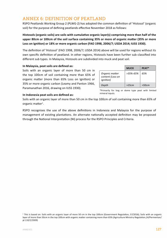
ANNEXES 127
AnneX 6: defInItIon of peAtlAndRSPO Peatlands Working Group 2 (PLWG-2) has adopted the common definition of ‘Histosol’ (organic soil) for the purpose of defining peatlands effective November 2018 as follows:
Histosols (organic soils) are soils with cumulative organic layer(s) comprising more than half of the upper 80cm or 100cm of the soil surface containing 35% or more of organic matter (35% or more Loss on Ignition) or 18% or more organic carbon (FAO 1998, 2006/7; USDA 2014; IUSS 1930).
The definition of ‘Histosol’ (FAO 1998, 2006/7; USDA 2014) above will be used for regions without its own specific definition of peatland. In other regions, Histosols have been further sub-classified into different sub types. In Malaysia, Histosols are subdivided into muck and peat soil.
In Malaysia, peat soils are defined as:Soils with an organic layer of more than 50 cm in the top 100cm of soil containing more than 65% of organic matter (more than 65% Loss on Ignition) or 35% or more organic carbon (Leamy and Panton 1966, Paramanathan 2016, drawing on IUSS 1930).
In Indonesia peat soils are defined as:Soils with an organic layer of more than 50 cm in the top 100cm of soil containing more than 65% of organic matter1.
RSPO recognises the use of the above definitions in Indonesia and Malaysia for the purpose of management of existing plantations. An alternate nationally accepted definition may be proposed through the National Interpretation (NI) process for the RSPO Principles and Criteria.
1 This is based on: Soils with an organic layer of more 50 cm in the top 100cm (Government Regulation, 57/2016); Soils with an organic layer of more than 50cm in the top 100cm with organic matter containing more than 65% (Agriculture Ministry Regulation,14/Permentan/pl.110/2/2009)
MUCK PEAT*
Organic matter content (Loss on ignition)
>35%-65% 65%
Depth >15cm >50cm
*Primarily for bog or dome type peat with limited mineral inputs.
RSPO MANUAL ON BEST MANAGEMENT PRACTICES (BMPs) FOR EXISTING OIL PALM CULTIVATION ON PEAT128
fIre preventIonPeat fire prevention and control comprises three main activities:
i. To prevent peat fire from occurring
ii. To extinguish peat fires rapidly while they are still small
iii. To practice zero burning at all times
In order for peat fire control to be successful, a comprehensive control plan needs to be drawn up in advance. This plan will form the basis for
carrying out prevention and suppression of peat fires.
Peat fire prevention is the most important activity in fire control and is work that must be carried out continuously and diligently. Fire prevention is the most economical way of minimizing damages and losses arising from fire, without having to use expensive equipment. A simple concept for preventing combustion from taking place is to remove one of the three components of the fire triangle (oxygen, heat source and fuel).
AnneX 7: fIre preventIon And control
There are several strategies that can be used as a guide in efforts to prevent fire. These include:
wAter mAnAgement And monItorIngA major cause of peat fires can be attributed to the excessive drying of peatlands due to poor water management and over-drainage. Hence it is extremely important to ensure water in the plantation is managed effectively. A good water management system should also be able to remove excess surface and sub-surface water quickly during wet seasons and retain water for as long as possible during dry spells. Maintaining a moist peat surface will help to minimize the risk of accidental peat fire. Associated water management maps should also be utilized and drainage systems and water control structures well maintained, implemented and monitored. Care should be exercised to monitor and ensure water management activities within the plantation do not have adverse effects on adjacent peat swamp areas.
Water-levels in peat can fluctuate rapidly especially during rainy or dry seasons. It is therefore important to carry out regular water level monitoring. This can be done by installing water level gauges at strategic locations and at the entrances of collection drains behind each stop-off and numbered. It will be useful to have a full-time water management officer in each peat estate for effective and timely control of water at optimum level. This person would also be responsible for operating the water-gates, regular checking of bund condition and inspection of water control structures for damage, blockages, etc. There should also be coordination between the water management team and fire suppression units to jointly identify dry and fire- prone areas within the plantation.
fIre InformAtIon SYStem ApproAchOne component in the success of fire prevention measures is a system for providing information about the possibility of fire breaking out, in which the information is distributed well to all relevant stakeholders, including those in the field. Conventionally, this information system is implemented through direct observations in the field (at locations prone to fire) and the use of maps and compasses. Today, with the help of modern technology (computers, telecommunications equipment and remote sensing), it is possible to develop a fire information system based on factors that affect the incidence of fire such as fuel conditions, climate conditions and fire behavior. Types of fire information systems:
i. EARLy WARNING SySTEM developed using daily weather data as a basis for calculating the drought index. The drought index indicates the moisture deficiency level of the soil and land. Fire viewing towers are also an effective component of early warning systems.
ANNEXES 129
ii. FIRE DANGER RATING SySTEM (FDRS) is an early warning system concerning the probability of fire occurring or not. This system was developed on the basis of indicators that influence the incidence of fire. The Malaysian Meteorological Department (MMD) has been producing the indexes and codes (in the form of maps) of FDRS for Southeast Asia on a daily basis since September 2003 . The Southeast Asia and Malaysia FDRS was adapted from the Canadian FDRS developed by the Canadian Forest Service. Daily maps of the FDRS are available at: http://www.met.gov.my/iklim/fdrs/mfdrs; http://www.met.gov.my/iklim/fdrs/afdrs
fIre SuppreSSIonFire suppression action should be taken as soon as possible when a peat fire occurs. The following strategies can be followed to ensure an effective fire suppression operation:
• HUMAN RESOURCES SUPPORTIt is essential that various elements of the community, NGOs, institutions and relevant agencies be involved in fire suppression action, in view of the fact that fire-fighting requires considerable human resources.
• IDENTIFICATION AND MAPPING OF WATER SOURCESWater sources (surface water and ground water) in fire-prone land and peat areas need to be identified and mapped. Identification should be carried out during the dry season so that when fires occur, there is a high probability that sources identified earlier will still contain water.
• FUNDING SUPPORTThe availability of adequate funds is essential. These funds can be used to provide food and drink for fire-fighters in the field, to mobilize the community to help in fire suppression activities, to acquire additional fire-fighting equipment and provide medical facilities for fire victims.
• ORGANIZATION OF FIRE-FIGHTING TEAMSIt is essential that fire-fighting teams have an organizational structure so that each team member understands his/her role, task and responsibility when carrying out fire-suppression activities.
• SUPPORTING FACILITIES AND INFRASTRUCTUREFire suppression activities must be supported by adequate facilities and infrastructure including:
· Road network
· Fire watch towers
· Communications equipment
· Telescopes and compasses
· Transportation vehicles include boats
· Fire engines, portable pumps, hoses and appropriate nozzle for fighting peat fire
· Heavy equipment (bulldozers, tractors)
· Other fire-fighting equipment such as fire beaters, axes, rakes, shovels
· Protective gear and equipment for fire-fighters (fireproof suits, boots, helmets, gloves, torches, machetes, drinking flasks)
· Emergency clinic, facilities for treating fire victims
• IDENTIFICATION OF SMOKE FREE ZONEIt is necessary to identify smoke free areas where fire victims can be evacuated, because smoke from fires has a negative impact on health, causing upper respiratory infections, skin allergies, asthma, etc.

RSPO MANUAL ON BEST MANAGEMENT PRACTICES (BMPs) FOR EXISTING OIL PALM CULTIVATION ON PEAT130
• STANDARD PROCEDURES ON FIRE- FIGHTINGFire-fighting involves the mobilization of all available people and equipment. Procedures must also cover information on monitoring and preparations (before going to the site and at the site).
SPECIFIC GUIDANCE ON TECHNIQUES FOR SUPPRESSION OF LAND AND FOREST FIRE IN PEATLAND AREAS:
Figure A5-1: Close up example of fire boat used for fire suppression activities in oil palm plantations on peatland.
Figure A5-2: Field demonstration of water spraying for fire suppression.
1. Determine the direction in which the fire is spreading (this can be done by observation from a higher point or by climbing a tree or from a watch tower).
2. If applicable, consider flooding the burning area by controlling water levels (i.e. adjusting weirs and water gates).
3. Before initiating fire suppression, a water-saturated transect is constructed to slow down the spread of the fire, acting as a non-permanent fire break.
4. To prevent fire from jumping across, it is necessary to cut down dead trees, which are still standing upright (snags).
5. If there are no water sources in the area, boreholes must be sunk. If the water sources are far from the fire, water supply is obtained through a relay (using several water pumps).
6. Direct fire suppression should be done from the tail (back) or from the right and left sides of the fire. Do not attempt to fight the fire from the front (fire head) because this is extremely dangerous.
7. In burnt areas, mopping up operations must first be carried out to clear the area of embers and ensure that the fire is well and truly out. This is done by spraying water on the surface of the burnt land.
8. Fire-fighters must walk with great care, using 2 m long planks to prevent them from sinking into holes left by the fire.
9. Surface fire suppression is carried out by accurately directing a jet of water at the source of the blaze, using a pump.
10. If the fire is in the tree crowns, direct suppression can be carried out with the help of heavy equipment such as aircraft, tractors and bulldozers.
11. In cases of ground fire, especially in peatlands during the dry season, suppression is done using a peat spear, which has a hole at the end. The spear’s nozzle is jabbed into the smoking ground until the peat fuel takes on the appearance of porridge, a sign that it is saturated with water. This ground piercing is continued until the fire has been extinguished.
12. It is essential to extinguish all remnants of the fire, considering that such remnants, concealed beneath stumps and charred debris on peatlands, are often overlooked.
13. The area of the fire should be inspected approximately one hour after the fire remnants have been extinguished, with the purpose of ensuring that the area is truly free from fire.
ANNEXES 131
ZERO BURNING ON PEATLANDZero burning is a policy adopted by the member states of ASEAN to overcome the problem of transboundary haze pollution due to fire. For this purpose, ASEAN has prepared a manual to serve as a guide to implement the zero burning policy. Several important points regarding the techniques for preparing land without burning are quoted from this manual and given below (ASEAN Secretariat, 2003):
The zero burning technique is a method of land clearing whereby the existing plantation are felled, shredded, stacked and left in-situ to decompose naturally. It is noted that shredding felled oil palms is more difficult on peat soil compared to mineral soils due to the physical properties of peat so alternative technologies like industrial shredders are recommended.
Basic steps in Zero Burning techniques for replanting of oil palm:
1. Planning for replanting
2. Removal of Ganoderma diseased palms
3. Pre-lining
4. Planning and implementation of any new roads and drains
5. Felling and shredding/chipping of old palms
6. Stacking/windrowing
7. Lining, holding and planting of oil palm seedlings
8. Pulverization
9. Post-planting management
BoX 15guIdelIneS for the ImplementAtIon of the ASeAn polIcY on Zero BurnIng (ASeAn SecretArIAt, 2003).THE ZERO BURNING TECHNIQUE FOR REPLANTING ON PEATReplanting on peat areas is more challenging from the operational as well as environmental perspectives. Peatlands in the tropics usually cover extensive areas and they perform vital hydrological and ecological functions for the entire landscape. In view of this, it is critical that comprehensive environmental impact assessments are conducted to ensure that the proposed replanting does not have significant adverse impact on the ecosystem.
Although the zero burning technique for peat areas would follow the same process of felling and stacking and planting of oil palm as that for replanting of oil palm on mineral soils, the inherent nature of peat would demand additional management inputs, particularly in respect of water management, land preparation and fertilization of the crop. Consequently, the cost of oil palm development on peat can be expected to be significantly higher than that for (Sarawak, Malaysia) areas on mineral soils.
• WATER MANAGEMENTIn their natural state, peat areas have a high water table and are often waterlogged. Effective water management holds the key to the successful development of oil palm on peat areas. An effective drainage system comprising main and subsidiary drains in a grid pattern that is integrated with the road system should have been put in place before zero burning operations commence. The intensity and dimensions of the drains would depend on the water level, land gradient and physical properties of the peat, particularly depth. The aim is to maintain a consistent water table level of between 40 and 50 cm below the soil surface.
RSPO MANUAL ON BEST MANAGEMENT PRACTICES (BMPs) FOR EXISTING OIL PALM CULTIVATION ON PEAT132
• FELLING AND STACKINGFelling using an excavator should be done soon after any construction of additional drains and roads. Bulldozers are not suitable for this operation on account of the soft ground conditions. Old palms should be pushed over and uprooted wherever possible, and the trunks cut into manageable size by chain saws or special trunk chipping tools. The residual palms and debris should be stacked at the intensity of one windrow for every two palm rows.
• SOIL COMPACTIONPlanting of oil palms on areas that have not been adequately compacted would result in leaning of the palms and exposure of the roots. Additional compaction could be done by excavators about three to four weeks after any construction of additional subsidiary drains.
• HOLING AND PLANTING OF OIL PALMAs peat areas are inherently less fertile, consideration should be given to planting palms at a higher density; for example at 160 palms per ha compared with 136 - 148 palms normally adopted for mineral soils. In view of soil subsistence, deep planting of oil palm seedlings is advisable. This is achieved by the ‘hole within a hole’ method whereby a large hole with a 1.5 m diameter is dug to 25 - 30 cm depth at the planting point, followed by making a smaller hole of about 40 cm diameter and depth, which will serve as the actual planting hole. Holing can be done mechanically using a puncher attached to the boom of an excavator. The puncher is an implement with a square top section and a conical bottom section to make the ‘hole-in-hole’.

