)rup - houston
TRANSCRIPT

FormCommunity Impacts Assessment Technical Report
Form Version 2
TxDOT Environmental Affairs Division 710.01.FRM Effective Date: December 2020 Page 1 of 33
Project Name: Westpark Drive Paving and Drainage Project from South Dairy Ashford to Wilcrest Drive
Control Section Job Number (CSJ): 0912-72-385
Report Date: 11/16/2020
District: Houston County(ies): Harris County Let Date: June 2021
Project Classification: Categorical Exclusion
Report Version Draft Revised Final
Please refer to the italicized instructions throughout this form for guidance in determining which section should be completed. More detailed information on filling out this form is available in Section Two of the Environmental Handbook - Community Impacts, Environmental Justice, Limited English Proficiency and Title VI in the Community Impacts Assessment Toolkit available on TxDOT.gov. For further assistance in developing this report or to discuss review comments on previous analyses, please contact the Environmental Affairs Division (ENV).

Community Impacts Assessment Technical Report
Form Version 2
TxDOT Environmental Affairs Division 710.01.FRM Effective Date: December 2020 Page 2 of 33
A. Project Screening
Would the proposed project involve ANY of the following conditions?
Creation of a new grade separation that is limited to only one level (i.e. creating an overpass where one roadway will pass over another roadway, which does not result in a multi-level interchange).
Displacements are limited to structures that appear to be unoccupied or otherwise unused.
Expansion of the roadway pavement by the width of one vehicle lane or more, but the expansion islimited to a project area with at least one of the following main characteristics:
o Rural projects - characterized by scattered residences, sparse population overall, and has limited pedestrian activity adjacent to the project area
o Development is predominately industrial or agricultural o Widening roadway approaches for bridge work
Construction of a new - or extension of an existing - raised median or median barrier where at least one of the following project descriptions is true:
o Does not deny access to any driveways or cross streets (although travel patterns may still be impacted)
o Does not continue longer than 3 miles without a break or crossover o Does not occur in front of a school or emergency responder dispatch location such as
police stations, fire stations, or hospital emergency room (not to include standalone urgent care centers not associated with a traditional hospital)
No Completion of this Community Impacts Assessment Technical Report form is required.
Proceed to Section B.
Other Consult ENV SME to determine what level of documentation is required. After contacting, if the SME concurs that a summary statement is sufficient for this project, fill in the summary in the space provided below and leave this box checked.
Yes
If there is a reason to believe that the project would have the potential to result in adverse temporary or permanent impacts to community resources, proceed to Section B.
Otherwise, provide a brief summary of why community impacts are not anticipated in the text box below to conclude the analysis. Do not complete the remainder of this Community Impacts Assessment Technical Report Form.
Summary Statement
Prepared by:

Community Impacts Assessment Technical Report
Form Version 2
TxDOT Environmental Affairs Division 710.01.FRM Effective Date: December 2020 Page 3 of 33
B. Community Study Area
Please answer all of the following questions in full sentences and proceed to Section C.
1. Describe the overall objective of the improvements (e.g., to reduce congestion at anintersection, to improve operational efficiency, etc.).
The project purpose is to upgrade existing infrastructure and expand the Westpark Drive thoroughfare between South Dairy Ashford Road and Wilcrest Drive to form a continuous four-lane boulevard for the 2.13 mile-length of the project. The project consists of two twelve-foot-wide lanes on either side of a raised median with traditional breaks; a new dedicated bike lane; sidewalks; storm sewers; and traffic signals. Existing right-of-way is ample (100 feet) to accommodate these features.
2. Define the Community Study Area by identifying community study area boundaries, anddescribe the methodology used for developing the community study area (i.e. explain thereasoning for why the study area boundaries are appropriate for the project).
Attach a map showing the community study area, the location of the project limits, as wellas the locations of all community facilities within the study area (e.g., schools, places ofworship, health care facilities, recreation centers, social services, libraries, emergencyservices, etc.).
The community study area lies wholly within the city limits of Houston, Tx. Project boundaries areWestheimer Road to the north, Wilcrest Drive to the east, Alief Clodine Road to the south, andDairy Ashford Drive to the west. This area includes parts of three U.S.Census Tracts, five CensusBlock Groups, and 158 Census Blocks. See Exhibit 1: 2020 Aerial Photograph with CommunityStudy Area and Exhibit 2: 2020 Aerial Photograph with Census Tracts, in Attachments for thecensus division boundaries, and Exhibit 3: 2020 Aerial Photograph with Community Facilitieswithin the Community Study Area, for community facilities.
3. Describe existing land use and community character.
Land use is urban with a 2010 population density that was twice that of the City of Houston in2010. Of the nearly 12,000 acres in the community study area, 48 percent is classified asresidential and 19 percent is parks/open space. The Royal Oaks Country Club's Fred CouplesSignature Golf Course and the 46-acre Mike Driscoll Public Park contribute to the parks/openspace acreage. See Exhibit 4: 2020 Aerial Photograph with Existing Land Use within theCommunity Study Area, in Attachments.

Fo
rm
Co
mm
un
ity
Imp
acts
As
sess
men
t T
ech
nic
al R
epo
rt
Fo
rmV
ers
ion
2
TxD
OT
Env
iron
men
tal A
ffai
rs D
ivis
ion
71
0.01
.FR
M
Eff
ectiv
e D
ate:
Dec
embe
r 20
20
Pag
e 4
of
33
4.Id
enti
fy c
om
mu
nit
y fa
cili
tie
s w
ith
in t
he
co
mm
un
ity
stu
dy
are
a b
y lis
tin
g a
nd
des
cri
bin
g t
he
m in
th
e ta
ble
bel
ow
. Use
th
is t
able
to
in
form
wh
at is
incl
ud
ed i
n t
he
map
, des
crib
ed i
n B
.2 a
bo
ve.
# N
am
e o
f F
aci
lity
Ty
pe
of
Fac
ilit
y
(ex.
: sch
ool,
park
, pl
ace
of w
orsh
ip,
etc.
)
Pu
bli
c o
r P
riva
te?
Se
rves
a S
pec
ific
P
op
ula
tio
n?
Ad
jace
nt
to t
he
Pro
ject
?A
dd
itio
na
l De
tail
s/C
om
men
ts
1 M
akk
ah M
asjid
Gre
ate
r H
ous
ton
pla
ce o
f W
orsh
ip
Ye
s,
pub
lic
Su
ni m
osqu
e
Ye
sS
.Da
iry
Ash
ford
at
Wes
tpa
rkD
r.
2 H
ous
ton
Mu
nici
pal C
our
t go
vern
me
nt
Ye
s,
pub
lic
pub
lic c
ourt
N
oS
.Da
iry
Ash
ford
nea
r R
ich
mon
dA
ve.
3 B
ud
ew
ig I
nter
me
dia
te S
cho
ol
sch
ool
Ye
s,
pub
licpu
blic
sch
ool
No
S.D
air
y A
shfo
rd n
ear
Ric
hm
ond
Ave
.
4 O
utle
y E
lem
an
tary
Sch
ool
sc
hoo
l Y
es,
pu
blic
pub
lic s
choo
l N
oR
ich
mo
nd
Ave
.
5H
CA
Hou
sto
n H
eal
thca
re W
est
hos
pita
lY
es,
pu
blic
priv
ate
ho
spita
lN
oR
ichm
ond
Ave
.
6M
ike
Dri
scol
l Par
kp
ark
Ye
s,
pub
licpu
blic
par
kN
oW
.H
ous
ton
Ce
nte
r B
lvd
at
Wes
tpa
rk T
ollw
ay
7R
oya
l Oa
ks C
oun
try
Clu
bco
unt
ry c
lub
No
, pr
iva
tepr
iva
te d
eve
lop
men
tY
esW
est
par
k D
r. a
t B
onne
brid
ge
Way
Blv
d.
8M
etro
pol
itan
Tra
nsit
Aut
hori
tyW
est
par
k B
us
Op
erat
ing
F
aci
lity
Ye
s,
pub
licci
ty s
eric
e p
rovi
der
Yes
We
stp
ark
Dr.
at
Wilc
rest
Dr.
9A
lief
Ea
rly C
olle
ge
Hig
h S
cho
ol
sch
ool
Ye
s,
pub
licpu
blic
sch
ool
No
Hay
es R
d. a
t Mea
do
wg
len
Ln.

Co
mm
un
ity
Imp
acts
Ass
essm
ent
Tec
hn
ical
Rep
ort
Fo
rmV
ers
ion
2
TxD
OT
Env
iron
men
tal A
ffai
rs D
ivis
ion
71
0.01
.FR
M
Eff
ectiv
e D
ate:
Dec
embe
r 20
20
Pag
e 5
of
33
# N
am
e o
f F
aci
lity
Ty
pe
of
Fac
ilit
y
(ex.
: sch
ool,
park
, pl
ace
of w
orsh
ip,
etc.
)
Pu
bli
c o
r P
riva
te?
Se
rves
a S
pec
ific
P
op
ula
tio
n?
Ad
jace
nt
to t
he
Pro
ject
?A
dd
itio
na
l De
tail
s/C
om
men
ts
10
Ne
xus
Ch
ildre
n's
Ho
spita
l ho
spita
l Y
es,
pu
blic
bra
in in
juri
es, a
lso
trea
t ve
tera
ns
with
bra
in
inju
ries
No
Mea
do
wg
len
Ln. a
t W
ood
lan
d P
ark
Dr.
11C
ons
olat
e G
ener
al o
f C
ost
a R
ica
fore
ign
cons
ula
te
Ye
s,
pub
lic
fore
ign
rela
tion
s/tr
ade
No
Wilc
rest
Dr.
ne
ar
Ric
hm
on
d
Ave
.
12U
T T
yle
r H
ous
ton
Eng
inee
rin
g C
ent
er a
nd
Ho
usto
n C
omm
unity
C
olle
ge
, A
lief-
Ha
yes
Cam
pus
colle
geY
es,
pu
blic
pub
lic c
olle
ge
No
We
sth
eim
er R
d.
at H
ayes
Rd.
13
Ch
urch
at
the
Cro
ss
pla
ce o
f wor
ship
Y
es,
pu
blic
chur
ch
No
S.D
air
y A
shfo
rd a
t W
estp
ark
To
llway
14
De
part
me
nt o
f P
ubl
ic W
orks
se
wa
ge
tre
atm
ent
pla
ntY
es,
pu
blic
pub
lic w
ork
s N
oB
rays
Ba
you
at
W H
ous
ton
C
ent
er B
lvd
.
15
Alie
f IS
D C
ent
er f
or A
dvan
ced
Ca
reer
ssc
hoo
l Y
es,
pu
blic
hi
gh
scho
ol
No
W
Ho
usto
n C
ente
r B
lvd.
ne
ar
Wes
the
imer
Rd.
16H
ous
ton
Fire
Sta
tion
#83
fire
sta
tion
Ye
s,
pub
lic
city
ser
vice
pro
vid
erN
oB
reez
ewoo
d B
lvd
near
R
ichm
ond
<#>
<In
sert
Tex
t><
Inse
rt T
ext>
<Y
es/
No
><
Inse
rt T
ext
><
Yes
/No>
<In
sert
Tex
t>
<#>
<In
sert
Tex
t><
Inse
rt T
ext>
<Y
es/
No
><
Inse
rt T
ext
><
Yes
/No>
<In
sert
Tex
t>
<#>
<In
sert
Tex
t><
Inse
rt T
ext>
<Y
es/
No
><
Inse
rt T
ext
><
Yes
/No>
<In
sert
Tex
t>
<#>
<In
sert
Tex
t><
Inse
rt T
ext>
<Y
es/
No
><
Inse
rt T
ext
><
Yes
/No>
<In
sert
Tex
t>
<#>
<In
sert
Tex
t><
Inse
rt T
ext>
<Y
es/
No
><
Inse
rt T
ext
><
Yes
/No>
<In
sert
Tex
t>
<#>
<In
sert
Tex
t><
Inse
rt T
ext>
<Y
es/
No
><
Inse
rt T
ext
><
Yes
/No>
<In
sert
Tex
t>
<#>
<In
sert
Tex
t><
Inse
rt T
ext>
<Y
es/
No
><
Inse
rt T
ext
><
Yes
/No>
<In
sert
Tex
t>

Co
mm
un
ity
Imp
acts
Ass
essm
ent
Tec
hn
ical
Rep
ort
Fo
rmV
ers
ion
2
TxD
OT
Env
iron
men
tal A
ffai
rs D
ivis
ion
71
0.01
.FR
M
Eff
ectiv
e D
ate:
Dec
embe
r 20
20
Pag
e 6
of
33

FormCommunity Impacts Assessment Technical Report
Form Version 2
TxDOT Environmental Affairs Division 710.01.FRM Effective Date: December 2020 Page 7 of 33
C. Demographics
Attach tables and maps to this Community Impacts Assessment Technical Report form detailing race/ethnicity (including Hispanic or Latino persons), language, and income. The TxDOT Census Data Tool includes all of this information in its screening report. Include other demographic data as appropriate, such as employment, disability, and age data for the community study area. A template demographics table is provided as Appendix A of this form found in the CIA Toolkit. Following completion of this section, proceed to Section D.
1. What data sources were used?
U.S. Census Bureau
American Community Survey (ACS)
Texas Demographics Center
Texas Education Agency – “Texas Academic Performance Reports”
Site Visit – Date of Site Visit: <MM/DD/YYYY>
Current and/or historic aerial photographs
Other Houston-Galveston Area Council georeferenced datasets, TxDOT Community Impact Assessment (CIA) Tool
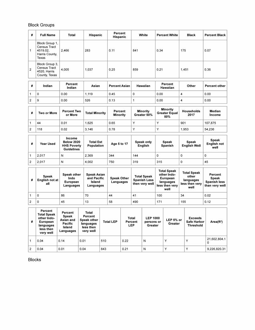
2. How many of the census geographies within the community study area indicate half or more of the population as minorities (e.g., 2 out of 10 census blocks within the community study area indicate half or more of their populations to be minorities)? Also consider whether any of the census geographies indicate an appreciably greater percentage of minorities compared to the next largest census geography (e.g., one block indicates a 45-percent minority population, while its parent block group indicates a five-percent minority population). What is the racial makeup of the minority census geographies? Minority data should be evaluated at the block level in most circumstances. Attach a map of these EJ census areas.
Of the 158 census blocks within the community study area, 102 had zero population in 2010. Of the remaining 56 census blocks with a positive population count in 2010, 32 blocks had ethnic populations greater than 50 percent. Two census blocks, 4519021029 and 4521002041, had 100 percent ethnic (non-white) populations. Seven other census blocks had ethnic populations comprising between 75 percent to 91 percent of their total populations.

Community Impacts Assessment Technical Report
Form Version 2
TxDOT Environmental Affairs Division 710.01.FRM Effective Date: December 2020 Page 8 of 33
The ethnic distribution within the community study area as a whole is 27 percent black or African American; 20 percent HIspanic or Latino; and 19 percent Asian. Census Block Group (CBG) 4519021 has the largest percentage (45 percent) of Asian Alone residents within the 5 CBGs in the community study area. CBG 4521002 has the largest percentage of white residents with 43 percent of residents identifying as White Alone. CBG 4521001 has the largest percentage of black residents with 44 percent identifying as Black or African American Alone.The percentage of Hispanic residents were fairly evenly distributed across the community study area with CBG percentages ranging from 19 to 24 percent of residents identifying as Hispanic or Latino. The exception to this observation is in CBG 4519021 where residents identifying as Hispanic or Latino comprised only 12 percent of the total population within the CBG.

Community Impacts Assessment Technical Report
Form Version 2
TxDOT Environmental Affairs Division 710.01.FRM Effective Date: December 2020 Page 9 of 33
3. What is the current U.S. Department of Health and Human Services (HHS) poverty level for a family of four, and what year is this based on?
$26,200, year 2020
4. How many of the census geographies show a median household income below the HHS poverty level? What are the median incomes of each those census geographies? If there are more than four block groups in the study area, list the range of incomes (e.g., Median income in the study area ranges from $32,415 to $47,651). Median household income should be evaluated at the block group level if available. Attach a map of these EJ census areas.
No CBGs presented median household incomes below the DHHS poverty threshold of$26,200 for a 2020 family of four. Median household incomes range across the five CBGs from a high of $98,750 to a low of $38,668. Income-to-poverty threshold ratios were correspondingly varied with a high of 3.8 times the poverty level in CBG 4519021 to 1.5 times the poverty level in Census Block Group 4521001.
5. Do any of the census geographies show the presence of persons who speak English “less than very well?” Which languages are spoken by those with limited English proficiency? Language spoken should be evaluated at the block group level if available.
The community study area is highly diverse in its composition with residents speaking more than 16 languages. Based on CBG data, the population within the community study area who speak only English or English very well, comprise 84 percent of the population. Conversely, other primary language speakers who speak English "less than very well" make up 16 percent of the resident population. Based on CBG data, the languages of residents who are not primary English speakers and who speak English "less than very well", in order of prevalence, are Spanish, Asian and Pacific Island, and other Indo-European languages. Primary languages among those who "speak English less than very well" are as follows in order of prevalence: Spanish, Chinese, Vietnamese, Arabic, Other Indic Languages, and Korean.
D. Site Visit
Following completion of this section, proceed to Section E.
1. Was a site visit conducted? If so, indicate when the site visit was conducted, attach documentation (including notes and photographs) from the field visit, and complete the rest of Section D.

Community Impacts Assessment Technical Report
Form Version 2
TxDOT Environmental Affairs Division 710.01.FRM Effective Date: December 2020 Page 10 of 33
A site visit should be conducted for most projects within a reasonable time frame to provide accurate and timely information. If not, explain why site visit was either not conducted at all or was conducted outside of the general time period as this form.
No commuinity site visit was conducted. COVID precautions prevented consideration of a site visit during a time of massive outbreaks. Remote sensing platforms, Google Earth, Google Maps, and internet resources were utilized in lieu of a site visit. The Hollaway Environmental team conducted a site visit in June 2020, but only within the immediate project area.
2. Were there signs observed in languages other than English? Describe the language(s) observed as well as the frequency and general location of signs in other languages (e.g., throughout the community study area, concentrated in a particular vicinity, etc.).
Signs, roadways, storefronts, and shopping establishments were all in English based on the sitevisit conducted by the Hollaway Environmental team in June 2020. This visit was confined to the immediate project area.
3. Were there places of worship, businesses, services, or other community facilities that target or primarily serve specific minority groups?
The community facilities list indicates places of worship that address the needs of specific cultural groups these include Makkah Masjid Greater Houston (a Suni mosque) and Church at the Cross. The Nexus Children's Hospital specializes in the treatment of brain injuries in children and also treats veterans with brain injuries. Otherwise, community facilities typically found across the metropolitan area were in evidence in the community study area such as public schools, medical hospitals and faciltiies, a Houston Municipal Court building, a fire station, and a sewage treatment plant. A notable outlier among typical community facilities is the location of the Consolate General of Costa Rica within the community study area. See Exhibit 3: 2020 Aerial Photograph with Community Facilities within the Community Study Area in Attachments.
4. Were there observable signs of persons with disabilities, such as ramps on homes or public transportation vehicles, or stops specifically designed for persons with disabilities?
Roadways and sidewalks in the immediate project area were equipped with ADA approved ramps and access. However, no additional specifically designed signs were observed during the Hollaway Environmental team site visit in June 2020.
5. Were there signs of other vulnerable populations (including children and elderly persons), such as the presence of daycares, elementary schools, or assisted living facilities?
The community facilities list identified a public elementary school in the community study area.

Community Impacts Assessment Technical Report
Form Version 2
TxDOT Environmental Affairs Division 710.01.FRM Effective Date: December 2020 Page 11 of 33
6. Were there signs of low-income populations or neighborhoods, such as government-subsidized housing, homes in disrepair, and low-cost health care facilities?
During the Hollaway Environmental team site visit in June 2020, houses appeared to be well-maintained in somewhat affluent residential areas. There was no indication of low-income populations such as stores advertising WIC or SNAP, low cost medical care offices, or establishments catering to this demographic group.
7. Were there signs of other modes of transportation, such as bus stops, train stations, or designated bicycle lanes or bicycle lane signage? Did you observe cyclists in the area? Are there sidewalks or trails? Did you observe dirt pathways from pedestrian activity adjacent to the proposed facility? If any of these signs are present, please describe their location and extent and show on a map, if necessary.
During the Hollaway Environmental team site visit in June 2020, discontinuous sidewalks wereobserved and there were a few areas where dirt paths were indicated by compressed vegetationwhere a sidewalk is being proposed. See Exhibit 5: 2020 Aerial Photograph with Existing and Proposed Bike Trails within the Community Study Area which shows the bike paths and lanes within the community study area.
8. Based on the observations made during the site visit and the data provided in Sections B and C, summarize the general character of the community study area. Consider the present condition as well as the overall development trends within the community study area.
The community study area is highly diverse in income and ethnicity. Languages spoken within thestudy area number in excess of 16 in addition to English. There appear to be cultural enclaves as exhbited by the predominance of differing ethnic groups within differing CBGs, all within the community study area. The Royal Oaks Country Club and surrounding development are indicative of the affluence within the study area. However the diversity extends to socioeconomic status as well. CBG 4519021 exhibits the highest median income of $98,750 within the community study area. The least affluent CBGs 4520003 and 4521001 have poverty levels of 23 and 21 percent, respectively.

Community Impacts Assessment Technical Report
Form Version 2
TxDOT Environmental Affairs Division 710.01.FRM Effective Date: December 2020 Page 12 of 33
E. Public Involvement
Following completion of this section, proceed to Section F. Attempts should be made to integrate public involvement throughout the NEPA process. If timelines or other factors affect the possibility of conducting public involvement before this CIA, it is recommended that public involvement documentation be shared with ENV SMEs at a later date.
1. Please describe the public involvement efforts planned or previously carried out for the proposed project. If no public involvement is planned, briefly explain why and proceed to section F.
Two presentations, one in English and one in Spanish, will be held virtually and will both beenabled with subtitles. The corresponding mailings will also be in English and Spanish. There willalso be published legal notices in English and in Spanish language newspapers (the Chronicle and La Voz) approximately 15 days prior to the hearing. For comments received in Spanish or any other language, a translator will be used so that the comment can be considered during project development. A virtual public hearing will be conducted according to TxDOT standards and protocols that are compliant with the National Environmental Policy Act (NEPA) when scheduled, likely in early 2021.
2. If public involvement has already occurred or is ongoing, what type of feedback has been received from the public regarding the proposed project or other community-related issues (i.e., what is the general sentiment of the public regarding the proposed project).
Several years ago, possibly 2013, the project team presented this project to the Houston CityCouncil. This meeting did not constitute an official project public meeting.
3. If public involvement has already occurred or is ongoing, and if feedback has been received from the public, how has this feedback been incorporated into the proposed project? Have attempts been made to address specific concerns of the public?
No feedback has been received from the public, either positive or negative, to date.

Community Impacts Assessment Technical Report
Form Version 2
TxDOT Environmental Affairs Division 710.01.FRM Effective Date: December 2020 Page 13 of 33
F. Displacements
Would the proposed project result in any potential displacements?
No Proceed to Section G, Access and Travel Patterns.
Yes Answer the questions in all applicable sections in F, then proceed to Section G. Check the types of displacements that apply:
Residential Answer all questions in Section F.1.
Commercial Answer all questions in Section F.2.
Other Such as places of worship, community centers, or schools, answer all questions in Section F.3.
1. Residential Displacements
a. How many residences would potentially be displaced subject to final design considerations (including those that would be impacted in a manner that would prevent them from being occupied because of loss of parking or access, etc.)? What types of residences would potentially be displaced (e.g., single-family homes, apartments, duplexes, etc.)?
<Insert Text Here>
b. Is there an adequate number of available replacement homes of comparable type, size, and cost? How was this determined? It should be noted that that costs associated with these properties are for analysis purposes only. Actual purchase price of acquired properties will be determined at the time of acquisition.
<Insert Text Here>

Community Impacts Assessment Technical Report
Form Version 2
TxDOT Environmental Affairs Division 710.01.FRM Effective Date: December 2020 Page 14 of 33
2. Commercial Displacements
If the number of employees at businesses that would be displaced represents less than five percent of the workforce in the community study area, then only the questions below should be answered.
If the number of employees at businesses that would be displaced represents more than five percent of the workforce in the community study area, then answer all of the questions in this section and refer to Appendix B in the CIA Toolkit for guidance on how to further analyze economic impacts (unless there is reason to believe that the overall economic impact of the displacements on the community would nevertheless be minor, in which case discuss with an ENV SME before completing all of the questions in this section).
a. What types of businesses exist in the study area (e.g., commercial, retail, industrial, medical, etc.)?
<Insert Text Here>
b. Which businesses would potentially be displaced subject to final design considerations (including those that are impacted in a manner that would prevent them from continuing to operate because of loss of parking, removal of access, etc.)?
<Insert Text Here>
c. Are these businesses unique to the area? How far would a person have to travel to find a business offering similar services?
<Insert Text Here>
d. Do these businesses serve a specific population such as persons with disabilities, children, the elderly, a specific ethnic group, low-income families, or a specific religious group?
<Insert Text Here>

Community Impacts Assessment Technical Report
Form Version 2
TxDOT Environmental Affairs Division 710.01.FRM Effective Date: December 2020 Page 15 of 33
e. Have any business owners indicated that they would or would not relocate if the proposed project is implemented? Base your answer on any information that is already available, there is no need to poll business owners for the sole purpose of answering this question.
<Insert Text Here>
f. Do customers generally access these businesses by car, mass transit, walking, or bicycling?
<Insert Text Here>
g. Are there replacement properties available for relocation of the businesses? Are there parcels available of comparable size, zoning, or special access needs (e.g., adjacent to a railroad)?
<Insert Text Here>

Community Impacts Assessment Technical Report
Form Version 2
TxDOT Environmental Affairs Division 710.01.FRM Effective Date: December 2020 Page 16 of 33
3. Other Displacements
Other displacements could include but are not limited to places of worship, community centers, or schools. If other displacements would occur, answer all of the questions in this section and proceed to Section G.
a. What non-residential and non-commercial displacements would potentially occursubject to final design considerations? Where are these facilities located?
<Insert Text Here>
b. Do the potentially displaced facilities serve a specific population such as persons with disabilities, children, the elderly, a specific ethnic group, low-income families, or a specific religious group?
<Insert Text Here>
c. Are there replacement properties available for relocation of comparable size or zoning?
<Insert Text Here>
d. How far would a person have to travel to find similar facilities or services?
<Insert Text Here>
e. Is there any opportunity to mitigate the impact to the facilities?
<Insert Text Here>

Community Impacts Assessment Technical Report
Form Version 2
TxDOT Environmental Affairs Division 710.01.FRM Effective Date: December 2020 Page 17 of 33
G. Access and Travel Patterns
Would the project result in permanent change to or loss of existing access, creation of new access, or permanent change in travel patterns to any modes of transportation?
No Proceed to Section H, Community Cohesion
Yes Answer questions in the applicable sections
If the project would improve an existing facility (including construction of new frontage roads along an existing highway), complete Section G.1. only and proceed to Section H.
If the project would be constructed on new location but would not create a new bypass or reliever route, complete Section G.2. only and proceed to Section H.
If the project would create a new bypass or reliever route, complete Sections G.2. and G.3. and proceed to Section H.
1. Changes in Access and Travel Patterns for Projects on Existing Facilities
a. What modes do people currently use to access destinations in the community study area (car, walking, cycling, and/or mass transit)?
Currently, transporation modes to access destinations in the community study area are via vehicles, walking, cycling, and mass transit (such as Metro buses).
b. Describe the current travel patterns along the existing facility and within the community study area. Consider the travel patterns observed during the site visit as well as the potential origins and destinations of trips for people in the community study area. Consider all modes if multiple modes are used in the community study area.
The residential areas bounding Westpark Drive to the north and south are planned residential neighborhoods with fenced or brick walls that limit access to the improved roadway. There is a narrow sidewalk along the roadway with some evidence of goat trails where a sidewalk does not occur.
c. Describe how the proposed project would permanently change access and travel patterns along the facility and within the community study area compared to the

Community Impacts Assessment Technical Report
Form Version 2
TxDOT Environmental Affairs Division 710.01.FRM Effective Date: December 2020 Page 18 of 33
existing condition, including beneficial and adverse impacts. Please include estimated travel time changes, as appropriate.
There will be no permanent interruption to travel patterns within the surrounding community. It is likely that transportation within the area will be improved with wider sidewalks and a dedicated bike lane.
As part of the project design, raised medians will be installed throughout the project area. The medians range in spacing from 215 to 1,230 feet maintaining access to adjacent businesses and residential neighborhoods. Medians near the residential neighborhoods are longer. The busier intersections at Wilcrest Drive, West Houston Center Boulevard, and South Dairy Ashford have shorter medians enabling more efficient cross-traffic access to businesses, parks, and nearby establishments. The project was also designed to maintain the existing medians where they occurred to enable consistent and reliable access.
d. Describe the specific areas that would be affected by these changes, such as residences or businesses. Which community facilities listed in Section B.g. would be affected? Do any of the community facilities provide “essential services,” such as clinics, schools, or emergency response?
It is anticipated that the improved facility will maintain safe and traditional access to nearby neighborhoods, parks, and nearby establishments.
e. How would the proposed project affect emergency response times? Please calculate added distance and/or estimated travel times for any potential response time increases.
There would be no effect to emergency response times with the construction of the project, as all roadways will maintain consistent access to roadways, neighborhoods, and establishments.
f. Are there active farms or ranches in the community study area? If so, would the project affect the movement of farm equipment or livestock trailers across the highway?
There are no active farms or ranches in the community study area.
g. Are any design elements proposed to mitigate adverse impacts to access and/or travel patterns?
There is no anticipated negative impacts associated with the project.

Community Impacts Assessment Technical Report
Form Version 2
TxDOT Environmental Affairs Division 710.01.FRM Effective Date: December 2020 Page 19 of 33
Community Impacts Assessment Technical Report
Form Version 2
TxDOT Environmental Affairs Division 710.01.FRM Effective Date: December 2020 Page 20 of 33
2. Changes in Access and Travel Patterns for Construction of Highway on New Locations
a. What modes do people currently use to access destinations in the community study area (car, walking, cycling, and/or mass transit)?
<Insert Text Here>
b. Describe the current travel patterns within the community study area. Consider the travel patterns observed during the site visit as well as the potential origins and destinations of trips for people in the community study area. Consider all modes if multiple modes are used in the community study area.
<Insert Text Here>
c. Describe the changes in access and travel patterns that would result from the proposed project, including any beneficial and adverse impacts. For new location projects, consider whether access to previously inaccessible areas would be created, as well as how the introduction of the project to the area could change previously established travel patterns on other facilities in the community study area.
<Insert Text Here>
d. Describe the specific areas that would be affected by these changes. What residences or businesses are located near the proposed new-location facility? Which community facilities listed in Section B.d. would be affected? Do any of the community facilities provide “essential services,” such as clinics, schools, or emergency response?
<Insert Text Here>
e. How would the new highway affect emergency response times?
<Insert Text Here>
f. Is land adjacent to the new-location highway available for development?
<Insert Text Here>

Community Impacts Assessment Technical Report
Form Version 2
TxDOT Environmental Affairs Division 710.01.FRM Effective Date: December 2020 Page 21 of 33
g. Are there active farms or ranches in the community study area? If so, would the project affect the movement of farm equipment, livestock, or trailers across the highway?
<Insert Text Here>
h. Are any design elements proposed to mitigate adverse impacts to access and/or travel patterns?
<Insert Text Here>

Community Impacts Assessment Technical Report
Form Version 2
TxDOT Environmental Affairs Division 710.01.FRM Effective Date: December 2020 Page 22 of 33
3. Changes in Access and Travel Patterns for New Bypass or Reliever Route Projects
a. What businesses are located along the existing corridor for which the bypass or reliever route would be created? Which of these businesses are primarily dependent on passing traffic for business (e.g., gas stations, restaurants, hotels, etc.)?
<Insert Text Here>
b. Are frontage roads proposed as part of the project? If so, describe the type and location of the frontage roads.
<Insert Text Here>
c. Describe any mitigation or design element, such as new signage, proposed to address adverse impacts to existing traffic-dependent businesses.
<Insert Text>

FormCommunity Impacts Assessment Technical Report
Form Version 2
TxDOT Environmental Affairs Division 710.01.FRM Effective Date: December 2020 Page 23 of 33
H. Community Cohesion
Does the project involve one or more of the following elements?
Construction of a highway on new location
Construction of a new grade separation of more than one level
Construction of a new interchange
Expansion of an existing facility or interchange by a width equal to or greater than an existing travel lane.
Upgrade of a non-freeway facility to a freeway facility
Addition of tolled or managed lanes
Construction of a new raised median or extension of an existing raised median that will prevent access to a least one driveway or cross street.
Introduction of a new median along a previously undivided facility
No Proceed to Section I, Environmental Justice.
Yes Answer all questions in this section and proceed to Section I. .
1. Briefly characterize the existing level of community cohesion. Ideally, this information should be based on feedback from members of the affected community or communities. If no such information is available, rely on geographic characteristics, development patterns, and observations made during the site visit.
Community cohesion is based on shared demographic characteristics within an area, in addition to personal identification with the area, shared traffic patterns, and general societal recognition of a place.The community study area is highly diverse ethnically and economically as data presented have indicated. However, differing ethnic cultures appear to cluster together across the community study area. Examples include Census Block Group 4519021 with 45 percent of its population identifying as Asian and Census Block Group 4521001 with 44 percent of its population identifying as Black or African American.
2. Describe whether construction of the proposed project would change the existing level(s) of separation experienced near the project area. Changes in separation could include but are not limited to introduction of a new physical barrier; expansion of an existing physical barrier; or contribution to a perceived sense of separation by constructing a new grade separation. Consider all modes if multiple modes are used in the community study area.
The modification proposed for Westpark Dr. will build a continuous four-lane thoroughfare through the project area and will increase the ease of traffic flow along that route. Drainage

Community Impacts Assessment Technical Report
Form Version 2
TxDOT Environmental Affairs Division 710.01.FRM Effective Date: December 2020 Page 24 of 33
modifications will improve rate of runoff and remedy rainwater ponding on roadways. The area immediately surrounding the project area, in CBGs 4519021 and 4521002, is affluent with a diverse ethnic population. Such a road modification will likely be considered an improvement by the local community.

Community Impacts Assessment Technical Report
Form Version 2
TxDOT Environmental Affairs Division 710.01.FRM Effective Date: December 2020 Page 25 of 33
3. Describe whether the changes associated with the proposed project (including impacts to access and travel patterns) would directly or indirectly result in separation or isolation of any geographic areas or groups of people. Consider all modes if multiple modes are used in the community study area.
The proposed road modification will likely improve access to all areas of the community study area with the ability to handle higher volumes of roadway traffic including vehicles, bicyclists, and pedestrians. Access to the existing bicycle trail system will also better connect the community overall. The neighborhoods bounding the roadway are walled with either fences or brick walls. It is unlikely that the installation of medians would affect community cohesion since they will be replacing those already in existence. No separation or isolation of population segments is anticipated.
4. Describe whether the changes associated with the proposed project would affect use of local services and community facilities. Would the project make access to these services and facilities more or less convenient? Would the frequency with which people access other parts of the community change? Consider all modes if multiple modes are used in the community study area.
Access to community facilities should be enhanced with the modifications proposed with this project. This project will allow for ease of traffic flow, drainage improvements, and a bike trail that will integrate into the existing and proposed bike trail system. The bike trail will support alternate modes of travel by providing an additional trail along the Westpark Drive route. Pedestrian traffic will be accomodated with the construction of sidewalks. See Exhibit 5: 2020 Aerial Photograph with Existing and Proposed Bike Trails within the Community Study Area, in Attachments.
5. Are any design elements proposed to mitigate adverse impacts to community cohesion?
No mitigation features are required as no negative impacts are anticipated outside of short-term, limited construction impacts.

Community Impacts Assessment Technical Report
Form Version 2
TxDOT Environmental Affairs Division 710.01.FRM Effective Date: December 2020 Page 26 of 33
I. Environmental Justice
Based on the data provided in Section C., does the community study area include any minority or low-income census geographies (i.e., “EJ census geographies”)?
No Proceed to Section J, Limited English Proficiency.
Yes Answer all questions in this section and proceed to Section J.
1. If the project would result in displacements, how many of these displacements would be located in EJ census geographies versus non-EJ census geographies?
No displacements will occur with this project.
2. Would there be impacts related to access and/or travel patterns? If yes, what types of impacts would occur in EJ census geographies versus non-EJ census geographies?
Short-term, limited impacts will potentially impact traffic flow during construction. However, there are numerous alternate route opportunities in the Study Area as follows:
East-West: Westheimer Rd; Richmond Ave; Alief Clodine Rd.
North-South: S. Dairy Ashford, W. Houston Center Blvd.; S. Kirkwood Rd.; Wilcrest Dr.
The short term construction impacts may pose acute, temporary impacts to the surrounding area with noise and air quality effects. However, no disproportionately high or adverse impacts are expected to occur to EJ populations within the community study area. The project area bounds an affluent area within the community study area that is separated from the street with a continuous brick wall or fencing that is set back from the roadway by a deep easement.
3. Would there be impacts related to community cohesion? If yes, what types of impacts would occur in EJ census geographies versus non-EJ census geographies?
Given that no displacements, decreased mobility, or decreased access will occur with this project, the study area's community cohesion is not expected to be impacted. The long term impacts associated with this proposed project are considered to be positive, contributing to vehicular traffic flow and increased amenities for pedestrian and bicycle use.
4. Do any of the displaced businesses, community facilities or services specifically cater to minority or low-income populations? Would the services provided cease, be reduced, or be forced to temporarily stop if displaced? If so, where is the nearest comparable service

Community Impacts Assessment Technical Report
Form Version 2
TxDOT Environmental Affairs Division 710.01.FRM Effective Date: December 2020 Page 27 of 33
provided? Consider the effects to EJ populations that reside within the community study area as well as EJ populations that may reside elsewhere but still rely on the services being provided by these establishments.
No displacements will occur with this project.

Community Impacts Assessment Technical Report
Form Version 2
TxDOT Environmental Affairs Division 710.01.FRM Effective Date: December 2020 Page 28 of 33
5. Based on the other technical documentation prepared for the proposed project, would there be any impacts to the human environment (e.g., noise, air quality, etc.) that could affect the community study area? If yes, would these impacts occur in EJ census geographies or non-EJ census geographies?
Short-term, limited impacts from project construction may occur near the project site. Census Block Groups 4519021 and 4521002, surrounding the project area, possess populations with lower rates of poverty than the community study area overall. These Census Block Groups have the highest median household incomes among all the Census Block Groups in the community study area. While ethnic diversity is present in these Census Block Groups and qualify for EJ consideration, data suggest that ethnic populations within these Census Block Groups are affluent. The project area traverses these particular Census Block Groups and avoids any potential EJ considerations with regard to disproportionately impacting impoverished people. Residents of the Census Block Groups immediately surrounding the project area will be exposed to short-term construction impacts that are typical of roadway construction. No disproportionately high or adverse impacts are expected to accrue to the surrounding EJ population.
6. Has the community experienced substantial impacts from past transportation projects such as a new roadway causing a large number of displacements or introducing a barrier and separating parts of the community? Describe any recurring community impacts that may be perpetuated by the proposed project.
It is highly unlikely that a disproportionate number of displacements occurred during the original construction of Westpark Drive because Andrau General Aviation Airport originally was located where the Royal Oaks Country Club is now situated within the community study area. This area developed as the Houston Metropolitan Area expanded with urban uses overtaking low density rural and suburban land uses
7. Have there been any major infrastructure projects, industrial facilities, or other large-scale developments constructed in or adjacent to the community area?
The Royal Oaks Country Club and the residential development that surrounds it are built on the Andrau General Aviation Airport site. The abandonment of general aviation activity in this area allowed for a large scale development, as the Country Club that now exists, because a large parcel of land was opened to development. Additionally, removal of use restrictions surrounding the airport allowed for additional urban development to occur.
8. Are there any minimization or mitigation efforts proposed specifically to lessen impacts to EJ populations?
While community study area residents are protected by their racial and ethnic makeup, there is no indication that the ethnic populations within CBGs 4519021 and 4521002, that encompass the

Community Impacts Assessment Technical Report
Form Version 2
TxDOT Environmental Affairs Division 710.01.FRM Effective Date: December 2020 Page 29 of 33
Westpark Dr. project area, are impoverished. As noted previously, poverty does exist within the community study area, but the CBGs that exhibit the higher levels of poverty are located along the northern boundary of the community study area, along Westheimer Rd, away from the immediate impacts of construction and operation of Westpark Dr. The EJ population that lives immediately adjacent to the project area are separated from the construction by continuous walls and deep easements. Impacts to these EJ populations are not expected to be disproportionately high or adverse.
9. In consideration of all the impacts to EJ populations described above and any mitigation proposed, would impacts to EJ populations be disproportionately high and adverse when compared to impacts to and mitigation for impacts to non-EJ populations? Describe why or why not.
The community study area has a diverse population with regard to ethnicities which qualify for EJ consideration. The need for EJ consideration of low-income persons is not as pronounced given the affluence of the resident population. The general affluence of the population is shared across ethnic populations. Any likely adverse impacts to these affluent EJ populations will most likely be mitigated by their available economic resources. Therefore, it is not anticipated that EJ populations will be impacted in a manner that is disproportionately high or adverse when compared with impacts to non-EJ populations living the same vicinity.

Community Impacts Assessment Technical Report
Form Version 2
TxDOT Environmental Affairs Division 710.01.FRM Effective Date: December 2020 Page 30 of 33
J. Limited English Proficiency
Based on the data provided in Section C. and observations made during the site visit, are LEP persons likely to be present in the community study area? Remember that requests for accommodations must be considered, and in most cases provided.
No Proceed to Section K, Conclusions.
Yes Answer all questions in this section and proceed to Section K.
1. What languages do the LEP persons likely to be present in the community study area speak?
Languages of residents who are not primary English speakers and who speak English "less than very well," in the order of prevalence, are Spanish, Chinese, Vietnamese, Other Indic Languages, Arabic, and Korean.
Based on CBG data, the population within the community study area who speak only English or English very well, comprise 84 percent of the population. Conversely, other primary language speakers who speak English "less than very well" make up 16 percent of the resident population. Based on CBG data, the languages of residents who are not primary English speakers and who speak English "less than very well", in order of prevalence, are Spanish, Asian and Pacific Island, and other Indo-European languages.
2. If public involvement events have occurred or are ongoing, then describe the accommodations that have been made for LEP persons during the public involvement process. Was assistance in a language other than English requested or is it anticipated to be requested? Were notices for public involvement opportunities provided in languages other than English? Were services such as translation or interpretation provided during public involvement events?
Alternatively, describe why no accommodations were provided.
Public involvment events are currently ongoing. As part of the public involvement being conducted, two presentations, one in English and one in Spanish, will be held virtually and will both be enabled with subtitles. The corresponding mailings will also be in English and Spanish. There will also be published legal notices in English and in Spanish language newspapers (the Chronicle and La Voz) approximately 15 days prior to the hearing. For comments received in Spanish or in any language other than English, a translator will be used so that the comment can be considered during project development. A virtual public hearing will be conducted according to TxDOT standards and protocols that are compliant with NEPA when scheduled, likely in early 2021.

Community Impacts Assessment Technical Report
Form Version 2
TxDOT Environmental Affairs Division 710.01.FRM Effective Date: December 2020 Page 31 of 33
3. Are more public involvement efforts planned? If yes, has the plan to accommodate LEP persons changed based on past public involvement feedback?
Currently the expectation is to present notices, mailings, and materials for public consumption in English and Spanish.

Community Impacts Assessment Technical Report
Form Version 2
TxDOT Environmental Affairs Division 710.01.FRM Effective Date: December 2020 Page 32 of 33
K. Conclusions
Following approval of the Community Impacts Assessment Technical Report form by TxDOT ENV, this summary must be included in the draft EA or draft EIS, if one is being prepared.
In the text box provided below, provide a summary of the analysis conducted above and include the following information:
Whether EJ populations occur within the community study area
Summary of impacts related to displacements
Summary of impacts related to access and travel patterns
Summary of impacts related to community cohesion
Summary of impacts to EJ populations, including a statement regarding whether, in consideration of all the impacts to EJ populations described above and any mitigation proposed, impacts to EJ populations would be disproportionately high and adverse when compared to impacts to and mitigation for impacts to non-EJ populations
Summary of LEP issues and accommodations
If some of the above components of the analysis do not apply to a particular project, please indicate this in the conclusion statements (i.e., “The proposed project would not result in any displacements; therefore, a displacements analysis was not required.”).
The community study area is diverse in income and ethnicity. There are many ethnic populations that occur in the community study area, including those who qualify for EJ consideration. Languages spoken within the study area number in excess of 16 in addition to English. The most common languages spoken in the study area include English, Vietnamese, and Spanish. There appear to be cultural enclaves as exhibited by the predominance of differing ethnic groups within differing Census Block Groups, all within the community study area. The Royal Oaks Country Club and surrounding development are indicative of the affluence within the study area. The community study area will have no negative long-term impacts from the proposed project. Long-term positive impacts are expected with improved traffic flow, community cohesion, and improved drainage in the project area, as well as increased amenities for bicycle and pedestrian traffic. The new bicycle lane will integrate into the existing bike path network within the City of Houston. Based on the information above, it is not anticipated that EJ populations will be disproportionately highly or adversely affected when compared to non-EJ populations. The proposed project would not result in any displacements; therefore, a displacements analysis was not required. No changes to access or travel patterns are anticipated in the long term with this project. Traffic flow and street drainage should improve.

Community Impacts Assessment Technical Report
Form Version 2
TxDOT Environmental Affairs Division 710.01.FRM Effective Date: December 2020 Page 33 of 33
Based on the data provided, no disproportionately high or adverse impacts to EJ populations or impacts to community cohesion are expected.
To better address the surrounding community it is recommended that Vietnamese translators and translated materials also be made available to the public in addition to the Spanish language accommodations that are already planned.
Prepared by: Carol Hollaway, Senior Economist

ATTACHMENTS
EXHIBITS
2020 Aerial Photograph with Community Study Area 2020 Aerial Photograph with Census Tracts 2020 Aerial Photograph with Community Facilities within the Community Study Area 2020 Aerial Photograph with Existing Land Use within the Community Study Area 2020Aerial Photograph with Existing and Proposed Bike Trails within the Community Study Area


Rd
S Dairy Ashford St


Rd
S Dairy Ashford St

Rd
S Dairy Ashford St