rural address signs - alberta · issued: dec 2003 revised: dec 2006 rural address signs page 1 of 3...
TRANSCRIPT

Issued: DEC 2003
Revised: DEC 2006
RURAL ADDRESS SIGNS Page 1 of 3
PART HIGHWAY SIGNS
SECTION GUIDE AND INFORMATION SIGNS RECOMMENDED
PRACTICES SUB-SECTION
General In 1979, Strathcona County developed a rural address system to assist emergency services in quickly locating residences and developments in rural areas. The rural address system also provided a convenient method for motorists to locate residences and rural businesses without the clutter of directional signage at major highway intersections. The Strathcona County address system provided the basis for the rural address system, which is presently used across the province and is described in the following guidelines. In urban areas, different addressing systems may be used, as determined by the municipality. Other rural address systems may exist in Alberta, such as M.D. of Foothills’ rural street numbering system, which is an extension of the City of Calgary’s urban system. The type of addressing system to be used should be discussed with the rural municipality prior to installation. Preferred Rural Address System The preferred address system in the province is based on the Western Canada legal survey grid, as illustrated in Figure TCS-A-426.1. Townships in the province are numbered consecutively from 1 to 127 between the borders of the United States and the Northwest Territories. Each major township
road is numbered accordingly. New township road numbers are assigned by adding a zero to the township number. The intermediate Township Roads (road allowances) are numbered sequentially at two-mile intervals. Ranges are numbered sequentially from east to west, starting from the longitudinal meridian lines (4th, 5th or 6th meridian). New Range Road numbers are assigned by adding a zero to the range number. The intermediate range roads (road allowances) are numbered sequentially at one-mile intervals. Forced Road Allowances While many rural roads in Alberta form part of the survey grid road system, other roads are irregular and simply follow rivers, streams or the topography of the land. These roads are usually assigned an auxiliary township road number or range road number based on the alignment of the road (e.g. Range Road 223A). Numbering Individual Parcels Parcels of land along each numbered range and township road are numbered alternately from the intersection moving northerly on the range roads and westerly on the township roads, as shown in Figure TCS-A-426.1. The numbers are based on existing parcels and further anticipated subdivision
Issued: DEC 2003
Revised: DEC 2006
RURAL ADDRESS SIGNS
Page 2 of 3
and development. Odd numbers are assigned to parcels located on the south and east sides of the roads and even numbers assigned to parcels on the north and west sides of the roads. Rural Address Signs Rural address signs (similar to street signs on urban streets) are typically placed at the crossroads of Township Roads and Range Roads. Rural address signs provide Township Road and Range Road identification for reference by passing motorists. Motorists and emergency service personnel are able to navigate to residential and commercial developments located in the area through the rural address system. Advance Township/Range Road Signs Advance Township/Range Road signs may be placed in advance of the intersection to supplement rural address signs. An advance Township/Range Road sign can be placed in addition to, or in lieu of, the rural address sign to help motorists locate rural roads. Eligibility Rural municipalities may install rural address signs (range road, township road) at the intersection of a road allowance and a provincial highway without a permit. However, discussion and approval is required to ensure consistency in the province by meeting these guidelines. Alberta Infrastructure and Transportation will
also consider the following when discussing the municipality’s need for a rural address system:
• Rural address signs are installed on the nodes of a grid of road allowances similar to urban address signs placed on street corners.
• The signs provide emergency personnel and motorists with a reference to the grid road system.
• Rural address signs are not placed piece-meal at high volume intersections. Advance Township / Range Road signs supplement the rural address signs and are placed at all highway junctions with road allowances.
• Where an Advance Road Name sign exists, the road name sign and the advance township / range road sign may be consolidated onto the same structure.
• A network of rural address signs should be considered only if there is substantial residential development and addressing needs in their areas to warrant such a system.
• Rural address signs on highways are installed on a request basis only. The municipality is responsible for the full cost of implementation.
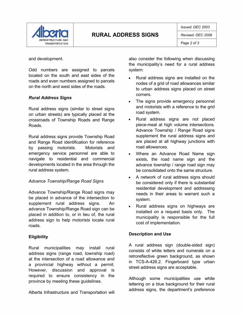
Description and Use A rural address sign (double-sided sign) consists of white letters and numerals on a retroreflective green background, as shown in TCS-A-426.2. Fingerboard type urban street address signs are acceptable. Although some municipalities use white lettering on a blue background for their rural address signs, the department’s preference

Issued: DEC 2003
Revised: DEC 2006
RURAL ADDRESS SIGNS
Page 3 of 3
is green. Green backgrounds fit the guide sign category while blue is typically used for motorist services such as gas, food, lodging, etc. The province will allow blue rural address signs if they already exist in the field, but new installations or replacement signs should be green. Details of the Advance Township/Range Road sign, and the combined Advance Township/Range Road sign and Road Name sign are found in TCS-A-426.3 and TCS-A-426.4, respectively. These Advance Road signs should have a green background, with no exception. Guidelines for Use Rural Address Signs Rural address signs may be placed at any rural intersection with a road allowance, except for highway to highway junctions. Intersections that intersect two highways have sufficient route marking to advise motorists of their location and rural address signs should not be required. The rural address signs are positioned in the corner areas of where the highway right-of-way boundary meets the road allowance boundary, as shown in TCS-A-426.4. Up to two signs may be placed in the diagonal quadrants on the near side corner when travelling on the highway. The signs are typically placed 1-2 metres from the properly line, inside the highway right-of-way. In any case, the sign should not be placed closer than 6 metres from the edge of the road shoulder, to assist in mowing operations.
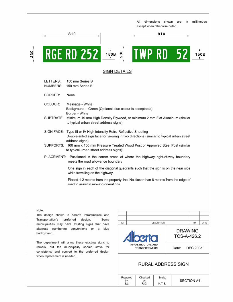
Advance Township/Range Road Signs Advance Township/Range Road signs must be placed a minimum of 6 metres from the highway shoulder line, 150-300 m in advance of the intersection, as shown in Figure TCS-A-426.5. Alternatively, Advance Township/ Range Road signs could be placed on the backslope near the fence-line, particularly if signage space approaching the intersection is unavailable. Installation and Maintenance A local government is responsible for the cost of supplying and installing rural address signs in the corner quadrants next to the right-of-way boundary and in advance of the intersection. When the sign(s) needs replacement, the municipality is responsible for the costs of supplying and installing replacement signs. The municipality is responsible for the maintenance of the rural address signs. References to Standards
Recommended Practices, Section: General
Placement of Signs

NO. DESCRIPTION BY DATE
DRAWING TCS-A-426.1
Date: DEC 2003
RURAL ADDRESS SYSTEM
Prepared by: S.L.
Checked by:
R.D.
Scale:
N.T.S. SECTION A4
Detail Plan
All dimensions shown are in millimetres except when otherwise noted.
NO. DESCRIPTION BY DATE
DRAWING TCS-A-426.2
Date: DEC 2003
RURAL ADDRESS SIGN
Prepared by: S.L.
Checked by:
R.D.
Scale:
N.T.S. SECTION A4
SIGN DETAILS
LETTERS: 150 mm Series B NUMBERS: 150 mm Series B BORDER: None COLOUR: Message - White
Background – Green (Optional blue colour is acceptable) Border - White
SUBTRATE: Minimum 19 mm High Density Plywood, or minimum 2 mm Flat Aluminum (similar to typical urban street address signs)
SIGN FACE: Type III or IV High Intensity Retro-Reflective Sheeting Double-sided sign face for viewing in two directions (similar to typical urban street
address signs). SUPPORTS: 100 mm x 100 mm Pressure Treated Wood Post or Approved Steel Post (similar
to typical urban street address signs).
PLACEMENT: Positioned in the corner areas of where the highway right-of-way boundary meets the road allowance boundary
One sign in each of the diagonal quadrants such that the sign is on the near side while travelling on the highway.
Placed 1-2 metres from the property line. No closer than 6 metres from the edge of road to assist in mowing operations.
Note: The design shown is Alberta Infrastructure and Transportation’s preferred design. Some municipalities may have existing signs that have alternate numbering conventions or a blue background. The department will allow these existing signs to remain, but the municipality should strive for consistency and convert to the preferred design when replacement is needed.
NO. DESCRIPTION BY DATE
DRAWING TCS-A-426.3
Date: DEC 2003
ADVANCE TOWNSHIP / RANGE ROAD SIGN
Prepared by: S.L.
Checked by:
R.D.
Scale:
N.T.S. SECTION A4
All dimensions shown are in millimetres except when otherwise noted.
SIGN DETAILS LETTERS: 100 mm Series C NUMBERS: 250 mm Series C BORDER: 10 mm edge COLOUR: Message – white
Border – white Background – green
SUBTRATE: Minimum 19 mm High Density Plywood, or minimum 2 mm Flat Aluminum SIGN FACE: Type III or IV High Intensity Retro-Reflective Sheeting
SUPPORTS: 100 mm x 100 mm Pressure Treated Wood Post or Approved Steel Post. PLACEMENT: In highway right-of-way, 150-300 m in advance of intersection. See placement
details in TCS-A-426.4

Rural Address Sign
1. Rural address signs are positioned in the corner areas where the highway right-of-way boundary meets the road allowance boundary.
2. Sign assembly is placed on the near side of the intersection when travelling on the highway.
3. The sign assembly is mounted 1-2 m from the property line, inside the highway right-of-way. A minimum clearance of 6 metres should be maintained from the edge of pavement and the sign post to assist in mowing operations.
Advance Township / Range Road Sign 1. Advance signs are only placed on any highway in
advance of the developed road allowance.
2. Advance rural address signs are placed 150 to 300 metres in advance of the crossroad intersection for both directions of travel.
3. Alternatively, advance signs may be placed at the limits of a highway right-of-way.
NO. DESCRIPTION BY DATE
DRAWING TCS-A-426.4
Date: DEC 2003
RURAL ADDRESS SIGNS PLACEMENT DETAIL
Prepared by: S.L.
Checked by:
R.D.
Scale:
N.T.S. SECTION A4
Alternate Placement
Minimum 6 m
Area of Placement
Area of Placement
Minimum 6 m
HIGHWAY
RO
AD
ALL
OW
AN
CE
Property Line
Typical Placement
6.0 m (min)