rural resilience enhancement project in the …open_jicareport.jica.go.jp/pdf/12237145_01.pdf ·...
TRANSCRIPT

MINISTRY OF AGRICULTURE OROMIA BUREAU OF AGRICULTURE OROMIA PASTORAL AREA DEVELOPMENT COMMISSION SOMALI LIVESTOCK, CROP AND RURAL DEVELOPMENT BUREAU
RURAL RESILIENCE ENHANCEMENT PROJECT IN THE FEDERAL DEMOCRATIC REPUBLIC OF ETHIOPIA
TECHNICAL MANUALS FOR RESILIENCE ENHANCEMENT IN PASTORAL AREAS
JANUARY 2015
JAPAN INTERNATIONAL COOPERATION AGENCY (JICA)
SANYU CONSULTANTS INC. RD
JR
15-012


FOREWORD
This Technical Manual is a part of outputs produced under the Rural Resilience Enhancement Project in the federal democratic republic of Ethiopia. The Project was commenced in April 2012 and carried out for a period of over 3 years in partnership with all those concerned officers of the Ministry of Agriculture, Oromia Bureau of Agriculture, Oromia Pastoral Area Development Commission, Somali Livestock, Crop and Rural Development Bureau. The Project produced, aside from series of pilot activities, following materials for the purpose of contributing to the resilience enhancement of rural communities and people dwelling in drought prone areas such as southern parts of Oromia region and Somali region:
1) Technical Manuals of Community Based Projects in Borena zone (this Volume) 2) Technical Manuals for Irrigated Agriculture in Gode Area
This Technical Manual is composed of 2 parts; namely Part I and Part II. Part I briefly discusses salient features of Borena zone by which the readers will be familiarized with the contexts wherein the people make their livelihood. Part II elaborates technologies based on the experiences of the Project, which include the implementation of pilot projects to examine the best ones appropriate in the context of the pastoral and agro-pastoral communities of Borena zone.
The Project, throughout the implementation of pilot activities, conducted various trials on Community Based Projects (CBPs), Pasture and Pasture Seed Production, Dryland Farming Improvement and Construction of Second Livestock Markets, lessons from which are incorporated in this Manuals. Most of the technologies described in this Manuals basically centers on low input and sustainable ones, thereby not depending much on outside assistances. Though ideas in this Manuals should not be over generalized, they are expected to be tools of practical application to further extend similar development activities to wherever there is potential applicability.
Readers of this Manuals are to be the Government frontline extension officers such as Development Agents (DAs) and Experts from Pastoral Development Offices (PDOs) or development practitioners engaged in rural development on the ground. We expect the readers to utilize this Manuals in respect of each condition, but also to try out the disciplines asserted throughout the text in practice. Being still humble enough for over generalization, experiences in the pilot projects are illustrated as much as possible corresponding to the general description of the ideas to indicate how the ideas are to be realized. However, we also believe that the actual experience is the living source of the text to be conveyed from its origin to various contexts.
JAPAN INTERNATIONAL COOPERATION AGENCY (JICA)


CONTENTS
PART I SALIENT FEATURES OF BORENA ZONE
1. TOPOGRAPHY .................................................................................................................................................................................... I-1 2. DEMOGRAPHY ................................................................................................................................................................................... I-1 3. CLIMATE .............................................................................................................................................................................................. I-2 4. TYPOLOGY .......................................................................................................................................................................................... I-3 5. APPLICATION OF THE MANUAL .................................................................................................................................................. I-7
PART II TECHNICAL MANUALS
1. RANGELAND MANAGEMENT COMPONENT ........................................................................................................................... II-1 2. AGRICULTURE COMPONENT ....................................................................................................................................................... II-2


I-1
PART I SALIENT FEATURES OF BORENA ZONE
1. TOPOGRAPHY
The Borena Zone is located at 3 degree 26 minutes – 6 degree 32 minutes N latitude and 36 degree 43 minutes – 40 degree 46 minutes E longitudes and its capital is Yabelo Town. It is located in the southern part of Oromia region. The Borena zone is divided into 13 woredas (districts) as shown in Figure 1, bordered in the south by Kenya, in northwest by the Southern Nations, Nationalities, and Peoples Regional State (SNNPRS), in northeast by Guji Zone, and in southeast by the Somali region.
As a zonal administrative entity it encompasses the total area of about 45,435 sq.km (CSA, 2011), equivalent to approximately 200 km square area. Most areas of Borena zone lies below 1,500m above mean sea level, especially in the eastern area bordering Somali region and southern part bordering Kenya. It is an arid and semi arid area with pockets of sub-humid zones. Of the area, grazing/browsing land covers about 18,712 sq.km (41%), bush and woodland about 15,510 sq.km (34%), and cultivated land about 3,421 sq.km (8%, 342,040 ha).
As is illustrated in Figure 1, Borena zone does not show great physiographic diversity. Vast area of the zone is warm semi-arid lowland (known as Gamoji in Afan Oromo). These wide areas are found in the southwest and eastern parts of the zone including Moyale, Dire, Arero, and Yabelo. Some cool-humid highlands (over 1500 m above sea level) are found only in north central and southern parts of the zone including some areas in Abaya, Bule Hora, Yabelo and Dire districts. Yabelo-Mega plateau rising to 2000m and some of the highlands of Bule-Hora with altitude over 2500m are the most notable highland sections of the Borena.
Grassing/browsing land shares the most of the Borena zone, reaching as much as 18,712 sq.km as aforementioned, equivalent to 41% of the total Borena zone. The rangelands are dominated by tropical savannah vegetation with varying proportions of open grasslands and perennial woody vegetation. Because of the
recurrent drought prevalence and rapid population increase in the area, rangeland recourses have depleted and are hardly able to carry livestock resources.
2. DEMOGRAPHY
In Ethiopia, the last national census was carried out in 2007. According to the census, the population of Borena zone was 962,489 as of year 2007, which shared 3.6% of the whole Oromia region’s population of 26,993,933. Given the total land area of 45,435 sq.km of Borena zone, the population density at year 2007 arrives at 21 persons only per sq.km, which is relatively low as compared with the averages of Oromia region and whole country, 76 persons per sq.km and 65 persons per sq.km, respectively.
In addition to the Census 2007, Finance and Economic Development Bureau of
Figure 1 Administration and Agro-ecological Map of Borena Zone
TelteleArero
Dire
Yabelo
Dillo
Dehas
MoyaleMiyo
Abaya
Gelana
Bule Hora
Dugda DawaMelka Soda
240000 330000 420000 510000 600000
3950
0047
0000
5450
0062
0000
6950
00
Source:GIS data UN-OCHA ,March 2012& Ministry of Agriculture,1998
0 30 60 90 12015 KM
·
LEGEND
Agroecology Type
Arid
Humid
Moist
Semi Arid
Semi Humid
Sub Moist
Water Body
Region & International Boundary
Wereda Boundary

I-2
Borena zone has been updating the population basically every year though there is always difficulty in keeping accuracy of counting the people. The Bureau shows there were 1,113,538 population as of year 2012, which was increased to 116% as compared with the population of last census year 2007. The inter-annual population growth over the 5 years thus arrives at as high as 3%. The 3% growth ratio means the population will double over the period of 24 years.
Figure 2 summarizes the population cohort by sex by a range of each 5-year age. As is well illustrated, the cohort shows very pyramidal appearance; the younger they are the more population presents. This kind of very pyramidal appearance usually shows up in such areas where high population growth ratio is accompanied. The population growth ratio in Borena zone is 3.0 % as aforementioned and also total fertility ratio as of Census 2007 was 5.95, which must have contributed to making such pyramidal cohort.
3. CLIMATE
Borena’s climate is basically divided into 2; namely the one for the mid-highland and highland areas, and the other for the lowland areas. The former is represented by Abaya, Galena and Bule Hora woredas while the latter by the rest 10 woredas falling in the lowland. The former shows quite similar climate to that of highland areas of Ethiopia while the latter is rather different. As is well known, there are bimodal rainy seasons in Ethiopia; and early rainy
season in a year provides less rainfall than that of late rainy season for the highland areas while the reverse takes place for the lowland areas of Borena.
The lowland areas are severely affected by recurrent droughts. Looking at the rainfall pattern in the lowland area, about 50% of annual rainfall occurs in the long rainy season (Ganna), which covers from March to May, while about 30% falls in the short rainy season (Hagaya) from September to November. The long dry season (Bona) occurs from December to February, and the short dry season (Adolessa) occurs from June to August. Variable rainfall results in great variability of pasture availability. To cope with variable pasture production, communities in Borena often combine mobility and sedentary livestock management.
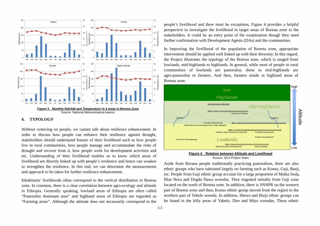
Average monthly rainfall and temperature data in the area are indicated in Figure 3. The data are taken from the National Metrological Agency (NMA) for stations found in different representative areas within Borena zone; i.e. Yabelo, Teltele, Moyale and Hagara Marian. Only Hagara Marian can be classified into highland area. The average annual rainfall ranges between 592 and 984 mm by station with considerable spatial and temporal variability in quantities and distribution. As Figure 3 shows, Ganna is more important rainy season than Hagaya in the area. On average, 51% of the annual precipitation concentrates on 3 months, March to May.
The climate of Borena zone varies from hot arid to warm semi-arid, and further to cool sub-humid. About 56% of the total area of the zone is characterized by hot arid (locally known as gamojji-ho’a), while about 31% and 13% of the total area is characterized by warm semi-arid (known as gamojji) and cool sub-humid (badda-dare) climate1. The warmest period in the year is from January to March while the lowest annual temperatures occur between the months of June and August. However, fluctuation of temperature is relatively moderate throughout of the year in Borena.
1 Oromia Land and Environmental Protection Bureau (2010)
Figure 2 Population Cohort in Borena ZoneSource: Census 2007 (CSA)
100000 50000 0 50000 10000
0 - 45 - 9
10 - 1415-1920-2425-2930-3435-3940-4445-4950-5455-5960-6465-6970-7475-7980-8485-8990-94
95+
MaleFemale
I-3
4. TYPOLOGY
Without centering on people, we cannot talk about resilience enhancement. In order to discuss how people can enhance their resilience against drought, stakeholders should understand feature of their livelihood such as how people live in rural communities, how people manage and accommodate the risks of drought and recover from it, how people work for development activities and etc. Understanding of their livelihood enables us to know which areas of livelihood are directly linked up with people’s resilience and hence can weaken or strengthen the resilience. In this end, we can determine the measurements and approach to be taken for further resilience enhancement.
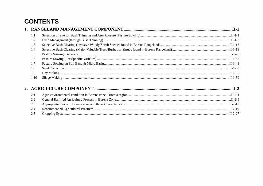
Inhabitants’ livelihoods often correspond to the vertical distribution in Borena zone. In common, there is a clear correlation between agro-ecology and altitude in Ethiopia. Generally speaking, lowland areas of Ethiopia are often called “Pastoralist dominant area” and highland areas of Ethiopia are regarded as “Farming areas”. Although the altitude does not necessarily correspond to the
people’s livelihood and there must be exceptions, Figure 4 provides a helpful perspective to investigate the livelihood in target areas of Borena zone to the stakeholders. It could be an entry point of the examination though they need further confirmation with Development Agents (DAs) and the communities.
In improving the livelihood of the population of Borena zone, appropriate intervention should be applied well linked up with their diversity. In this regard, the Project illustrates the typology of the Borena zone, which is ranged from lowlands, mid-highlands to highlands. In general, while most of people in rural communities of lowlands are pastoralist, those in mid-highlands are agro-pastoralist or farmers. And then, farmers reside in highland areas of Borena zone.
Aside from Borana people traditionally practicing pastoralism, there are also ethnic groups who have subsisted largely on farming such as Konso, Guji, Burji, etc. People from Guji ethnic group account for a large proportion of Malka Soda, Blue Hora and Dugda Dawa woredas. They migrated initially from Guji zone located on the north of Borena zone. In addition, there is SNNPR on the western part of Borena zone and then, Konso ethnic group moved from the region to the northern part of Teltele woreda. In addition, Shewa and Burji ethnic groups can be found in the hilly areas of Yabelo, Dire and Miyo woredas. These ethnic
Figure 3 Monthly Rainfall and Temperature in 4 areas in Borena ZoneSource: National Meteorological Agency
0
5
10
15
20
25
30
0
50
100
150
200
250
Jan Feb Mar Apr May Jun Jul Aug Sep Oct Nov Dec
Tem
pera
ture
(℃
)
Rai
nfal
l (m
m)
Yabelo
0
5
10
15
20
25
30
0
50
100
150
200
250
Jan Feb Mar Apr May Jun Jul Aug Sep Oct Nov Dec
Tem
pera
ture
(℃
)
Rai
nfal
l (m
m)
Teltele
0
5
10
15
20
25
30
0
50
100
150
200
250
Jan Feb Mar Apr May Jun Jul Aug Sep Oct Nov Dec
Tem
pera
ture
(℃
)
Rai
nfal
l (m
m)
Moyale
0
5
10
15
20
25
30
0
50
100
150
200
250
Jan Feb Mar Apr May Jun Jul Aug Sep Oct Nov Dec
Tem
pera
ture
(℃
)
Rai
nfal
l (m
m)
Hagara Marian
Most Communities in Malka Soda
Model 4 - Farmers’ Communities (Farming with little livestock)
Advanced Farming
Irrigation Irrigation
Farming ImprovementWater Resource Development for Cattle Migration
Weather Index Insurance (Livestock) Farming Improvement
Pasture DevelopmentSocial Tie Strengthening
Water Resource Development Bush Crearing
Mid-Highlands
LowModel 1 - Pastoral Communities (Livestock with little or no farming)
Model 2 - Livestock Oriented Agro-Pastoral Communities (Livestock with farming)
HighFarmers
Altitude
Highlands
Lowlands
Model 3 - Agriculture Oriented Agro-Pastoral Communities (Farming very important)
Figure 4 Relation between Altitude and LivelihoodSource: JICA Project Team

I-4
people practice agriculture by their tradition.
Figure 5 shows a generalized picture of people’s livelihood in Borena zone. Although emphases of sectors differs from area to area, a series of workshops organized by the Project team and field surveys revealed that livestock and water are the core sectors to be prioritized in this Borena zone. Since pastoralist moves for searching water and pasture, their livelihood is always affected by the availability of them. In addition to livestock and water, agriculture has also gradually become an important sector in Borena zone and people regard the sector as supplementing their livelihood for their cereal consumption. Thus, those three sectors directly contribute to people’s livelihood for resilience enhancement and should be investigated according to the areas they reside.
The patterns of food consumption also differ from area to area. Main foods available to the people at rural communities in Borena zone are milk and cereals. They hardly consume vegetables and meats on a daily basis. As Figure 5 shows, livestock can supply milk to the people. Besides, people can convert livestock to cereals by selling animals and purchasing crops. On the other hand,
agriculture can directly supply cereals by producing crops. Thus, the patterns of food consumption particularly depend on the level of pastoralism and farming in Borena zone.
It is obvious that while food supply by pastoralist mainly derives from livestock production, agro-pastoralist and farmers can also supply food from farming. Borena zone is traditionally pastoral area. However, the zone is nowadays diversifying and in fact many people have started farming. In general, people in lowland areas mainly rely on livestock production and a few people also practice farming. Meanwhile, people in middle highland to highland areas put high priority on farming in their livelihood and keep livestock to a lesser extent.
Based on a household survey conducted by the Project team, the Team designs a strategy of resilience enhancement for people’s livelihood in each categorized area. As Figure 5 illustrates, people’s livelihood in Borena zone consist of main three sectors, namely water, livestock and agriculture although prioritization of each sector differs from area to area (possibly olla/gare or PA2). In this context, the Team proposes 4 livelihood models in Borena zone for the strategy of resilience enhancement.
On the basis of current situation in a good and drought year, the strategy gives indications such as size of farmland a household needs or kalo (rangeland) a community needs to establish to secure people’s life. Such indications would show gaps on the ground to be filled in by the communities, government and donors and direct them to proper approach of resilience enhancement. Since water sector does not display distinctive trend in particular models and areas, the Team leaves the sector out of the indications.
In fact, it is difficult to predict whether a coming year becomes a good year or drought year. However, people should always keep in mind that drought comes in a next year and then prepare for the drought even in a good year in addition to quickly corresponding to the drought. For such preparation, the indications to be given here would be helpful.
2 Olla is a natural village, Gare is a smallest administrative village and PA (peasant association) is the same as kebele in highland.
Figure 5 People’s Livelihood in Borena zoneSource: JICA Project Team
Water for both Human and LivestockSmall Pond, Medium Pond, Ella (CBP by Olla / Gare / Rera level cooperative works)
Large (Permanent) Pond (Public Work by the Government / Donors)
Bush
cle
arin
g
Past
ure
Sow
ing
Cereals
People’s Livelihood in Borena
Low
land
←→
Mid
hig
hlan
d
RangelandDevelopment
Improved Dryland Farming
Cereals
Livestock
Mid Highland ← → Lowland
Agriculture
Agro-pastoralist ←→
Pastoralist(Experience) (Beginner)
MilkSelling livestock for Cereals
Low
land
←→
Mid
hig
hlan
d
Milk

I-5
Model 1 - Pastoral Communities
Model 2 - Livestock Oriented Agro-Pastoral Communities
16
Model 1 Community (>90%) Strategy for Normal Year300 Cattle + 330 Shoat
Establishment of Kalo for Drought40ha of Kalo can save 300 cattle from TWOmonth extended drought”
Minimizing No. of Cattle selling, they can sell shoat
Minimizing buying cereals
10ha Farmland/olla
40ha of Kalo/olla
Targeting 1,000kg/HH of Cereals from Farming2timad (=0.33ha) of Farmland can supply annual household consumption of cereals (1,000kg)
Current farmland=0.67ha
17
Model 1 Community (>90%) Strategy for Drought Year
300 Cattle + 330 Shoat
Selling One Cattle/HH or Seven Goat/HH (earning 7,000Birr)
OPEN 40ha of Kalo
NO Production Expected
Providing Residues to Livestock
Buying 1,000kg/HH of Cereals for Annual Consumption
18
Model 2 Community (70-90%) Strategy for Normal Year270 Cattle + 330 Shoat
Establishment of Kalo for Drought37ha of Kalo can save 270 cattle from TWOmonth extended drought”
Targeting 1,000kg/HH of Cereals from Farming2timad (=0.33ha) of Farmland can supply annual household consumption of cereals (1,000kg)10ha Farmland/olla
37ha of Kalo/olla
In fact, people have already secured the production!
Current farmland=1.17ha
19
Model 2 Community (70-90%) Strategy for Drought Year
270 Cattle + 330 Shoat
Selling One Cattle/HH or Seven Goat/HH (earning 7,000Birr)
OPEN 37ha of Kalo
NO Production Expected
Providing Residues to Livestock
Buying 1,000kg/HH of Cereals for Annual Consumption

I-6
Model 3 - Agriculture Oriented Agro-Pastoral Communities
Model 4 - Farmers’ Communities
20
Model 3 Community (30-70%) Strategy for Normal Year
60 Cattle + 240 Shoat
Establishment of Kalo for Drought8ha of Kalo can save 60 cattle from TWOmonth extended drought”
8ha of Kalo/olla
Needs more productivity on Farming
Targeting 2,000kg/HH of Cereals from Farming4timad (=0.67ha) of Farmland can supply annual household consumption of cereals (1,000kg)1,000kg can be used for selling or reserving.
20ha Farmland/olla
Current farmland=1.17ha
21
Model 3 Community (30-70%) Strategy for Drought Year
Cannot Sell Cattle because they use for animal drafting
OPEN 8ha of Kalo
60 Cattle + 240 Shoat
Supply 1,000kg/HH of Cereals from Stock reserved previous year or buying by savings
NO Production ExpectedProviding Residues to Livestock
22
Model 4 Community (<30%) Strategy for Normal Year
60 Cattle + 30 Shoat
Establishment of Kalo for Drought8ha of Kalo can save 60 cattle from TWOmonth extended drought”
Targeting 2,000kg/HH of Cereals from Farming4timad (=0.67ha) of Farmland can supply annual household consumption of cereals (1,000kg)1,000kg can be used for selling or reserving.20ha Farmland/olla
8ha of Kalo/olla
In fact, people have already secured the production!
Current farmland=1.17ha
23
Model 4 Community (<30%) Strategy for Drought Year
Cannot Sell Cattle because they use for animal drafting
OPEN 8ha of KaloSupply 1,000kg/HH of Cereals from Stock reserved previous year or buying by savings
NO Production ExpectedProviding Residues to Livestock
60 Cattle + 30 Shoat

I-7
Table 1 summarizes the indications for resilience enhancement shown for the above models. Especially, while indications with straight underlines show gaps on agriculture to be filled in by the communities, governments and donors, indications with wavy underlines show gaps on pasture development.
Table 1 Summary of Indications for Resilience Enhancement by Model Model Priority Year Strategy & Indication
Past
oral
C
omm
uniti
es
Min
imiz
e lo
ss o
f Li
vest
ock Goo
d Ensure 1,000kg of crop yield (maize) from 0.33ha of farmland per
household Toward drought, establish 40ha of reserve Kalo per Olla Minimize the number of animals for selling
Dro
ught
Should not expect supply of cereals from farming Sell one cattle or seven shoat per household and buy 1,000kg of
maize (or other cereals) Open 40ha of the reserved kalo
Live
stoc
k O
rient
ed
Agr
o-Pa
stor
al
Com
mun
ities
Min
imiz
e lo
ss o
f Li
vest
ock Goo
d
Ensure 1,000kg of crop yield (maize) from 0.33ha of farmland per household (already achieved)
Toward drought, establish 37ha of reserve Kalo per Olla Basically, selling of animals are unnecessary for supplying food
consumption
Dro
ught
Should not expect supply of cereals from farming Sell one cattle or seven shoat per household and buy 1,000kg of
maize (or other cereals) Open 37ha of the reserved kalo
Agr
icul
ture
Orie
nted
A
gro-
Past
oral
C
omm
uniti
es
Max
imiz
e cr
op p
rodu
ctiv
ity
Goo
d
Ensure 2,000kg of crop yield (maize) from 0.67ha of farmland per household (already achieved). 1,000kg can be consumed and
1,000kg should be reserved for next year or sold to others. Toward drought, establish 8ha of reserve Kalo per Olla. Basically, selling of animals is unnecessary for supplying food
consumption
Dro
ught
Cannot sell animals because the number is small Should not expect supply of cereals from farming Supply 1,000kg/HH of Cereals from Stock reserved previous year
or buying by savings Open 8ha of the reserved kalo
Farm
ers'
Com
mun
ities
Max
imiz
e cr
op p
rodu
ctiv
ity
Goo
d
Ensure 2,000kg of crop yield (maize) from 0.67ha of farmland per household. 1,000kg can be consumed and 1,000kg should be reserved for next year or sold to others.
Toward drought, establish 8ha of reserve Kalo per Olla Basically, selling of animals is unnecessary for supplying food
consumption
Dro
ught
Cannot sell animals because the number is small Should not expect supply of cereals from farming Supply 1,000kg/HH of Cereals from Stock reserved previous year
or buying by savings Open 8ha of the reserved kalo
5. APPLICATION OF THE MANUAL
Part II of this technical manual has been prepared with Process Description (PD) method3, which illustrates various kinds of technologies step by step. It is intended by following all the steps one can easily understand and also try what is described, though some are of conceptual explanation only. The technologies put in the Part II of this Manuals cover 2 sectors such as; 1) Rangeland Management, and 2) Dryland Farming Improvement.
Readers are expected to use the technologies in such a way of supporting the livelihood of the population of Borena zone. Those technologies described in this Manuals are expected to fill in the gaps on livestock production and agriculture, thereby giving strategy for resilience enhancement in their livelihood. Readers should have in mind there is no almighty technology applicable to each and every kind of environment. We should always think of contexts wherein the people make their livelihood, depending on which technologies should be selected, applied and modified as well. Therefore, actual experience starting at smaller scale may be the living source of the text to be conveyed from its origin to various contexts.
3 The word of “PD method” comes from “Process Description method”. This is a technology transfer method of producing an operation manual using photos or illustrations, which are portrayed by superposing on the photos, of a series of actual activities of a work. The process description is made by: 1) taking a series of photos of a work, 2) describing the activities in the photos by step, and 3) portraying the photos into illustrations. Hideyuki KANAMORI (1994): Effective Technology Transfer by PD Method (in Japanese), Journal of the Japanese Society of Irrigation, Drainage and Reclamation Engineering, Vol.62, No.12, pp.7-12


PART II TECHNICAL MANUALS

CONTENTS 1. RANGELAND MANAGEMENT COMPONENT ................................................................................................... II-1
1.1 Selection of Site for Bush Thinning and Area Closure (Pasture Sowing)......................................................................................................... II-1-1 1.2 Bush Management (through Bush Thinning) .................................................................................................................................................... II-1-7 1.3 Selective Bush Clearing (Invasive Woody/Shrub Species found in Borena Rangeland) ................................................................................ II-1-13 1.4 Selective Bush Clearing (Major Valuable Trees/Bushes or Shrubs found in Borena Rangeland) .................................................................. II-1-19 1.5 Pasture Sowing (General) ............................................................................................................................................................................... II-1-26 1.6 Pasture Sowing (For Specific Varieties) ......................................................................................................................................................... II-1-32 1.7 Pasture Sowing on Soil Band & Micro Basin ................................................................................................................................................. II-1-43 1.8 Seed Collection ............................................................................................................................................................................................... II-1-50 1.9 Hay Making .................................................................................................................................................................................................... II-1-56 1.10 Silage Making ................................................................................................................................................................................................. II-1-59
2. AGRICULTURE COMPONENT .............................................................................................................................. II-2 2.1 Agro-environmental condition in Borena zone, Oromia region ....................................................................................................................... II-2-1 2.2 General Rain-fed Agriculture Process in Borena Zone ..................................................................................................................................... II-2-5 2.3 Appropriate Crops in Borena zone and those Characteristics ......................................................................................................................... II-2-10 2.4 Recommended Agricultural Practices ............................................................................................................................................................. II-2-19 2.5 Cropping System ............................................................................................................................................................................................. II-2-27
Reference
1. Technical Manual For Forage Crops and Grassland In Tropical and Subtropical Zones, 1996, Japan Livestock Technology Association 2. Top Tropicals LLC (https://toptropicals.com/index.htm) 3. Community Based Participatory Watershed Development: A Guideline, 2005, Ministry of Agriculture (MOA), Ethiopia 4. Design Principles of Wood Burning Cook Stoves (for Energy Efficient Stove for Cooking), Aprovesho Research Centre, Shell Foundation,
Partnership for Clean Indoor Air 5. Report of the Application of Effective Micro-organisms Technology in Rice Patheingyi TS, Mandalay Division, 1998/99 – 2001/02 (for EM use) 6. Grass Roots Effective Agriculture Technology Handbook, AICAF, December 1996 (for treadle Pump, etc.) 7. The Molasses Block Technology in Mauritius and the African Perspective, Balraj Rajkomar, Department of Agricultural Production and System,
School of Agriculture, University of Mauritius, Reduit, Mauritius 8. FAO ASIAN LIVESTOCK, October 1990, Livestock-Food for the Future, Introduction of Modern Technologies for Better Animal Production in
Myanmar (for Livestock Sector) 9. Effective Technology Transfer by PD Method (in Japanese), Journal of the Japanese Society of Irrigation, Drainage and Reclamation Engineering,
Vol.62, No.12, pp.7-12, Hideyuki KANAMORI (1994) 10. Water Harvesting, 1991, Will C. and Klaus S., FAO, Rome. (http://www.fao.org/docrep/U3160E/u3160e00.htm) 11. African Organic Agriculture Manual Booklet Series, No. 8 Pest and Disease Management
( http://www.organic-africa.net/fileadmin/documents-africamanual/training-manual/chapter-04/Africa_Booklet_8-low-res.pdf )

II-1-1
1.1 Selection of Site for Bush Thinning and Area Closure (Pasture Sowing)
Step Process Description Remarks 1 Reason Why We Need Expansion of Rangeland
In order to expansion the rangeland, people conduct bush thinning at the areas where native grass is available and close there for a few years.
So that, they can establish a new “Kalo” with good native grasses.
2 Reason Why We Need Expansion of Rangeland
Or people also can sow the seed of some forage species in the degraded/bare land where native grass are unavailable.
After sowing, they should close the area for 3 to 5 years and avoid the entrance of both livestock and wild animals.
So that, they can make a new “Kalo” with good improved forages.

II-1-2
Step Process Description Remarks 3 Reason Why We Need Expansion of Rangeland
If people establish “Kalo” with Rhodes Grass
Productivity of Rhodes Grass is 3.8ton/ha.
If people have 10ha of Kalo (average size of Kalo found in Borena), people can produce 38 ton/ha of Rhodes Grass by sowing the seed in the degraded/bare land.
Productivity of Native grass is DM 3.1kg/ha while that of Rhodes grass is DM 3.8kg/ha in Borena zone*.
*Source: JICA study team
4 Reason Why We Need Expansion of Rangeland
If people establish “kalo” with Rhodes Grass
One animal consumes dry matters corresponding to 2.5 to 3% of body weight. Therefore, one cattle needs 7kg of Grass (DM) per day.
Thus, 38 ton of grass can feed approximately 180 cattle for one month. Even if, drought becomes prolonged one month longer, 180 cattle can survive.
In case of raring calves, more numbers can survive.

II-1-3
Step Process Description Remarks 5 Selection of Bush Encroached Area for Thinning
The most dominant invasive bush in target area, its extent and problems at communities’ rangeland should be identified through discussion with a community. Then, a site needs thinning should be selected through the participation of community.
Before thinning, important woody species should be identified and then marked. 2.3 and 2.4 shows lists of bush species which are both innovative and valuable.
Total clearing of bush has negative impact on land such as causing soil erosion. Thinning should be done by appropriate method. There are around 20 invasive bushes in Borana rangeland. Usually, they are specific to one area (means one species is invasive at one site while not at another site).
6 Characteristics of Aggressive Invasive Species
Capable to grow in poor fertile soil
Tolerant of moisture stress
Having physical and chemical defense mechanism (thorny, sour and etc.)
Shade leaves at prolonged drought time
Produce a lot of seed
Deep and shallow roots
These characteristic species should be cleared by communities.
All registered woody species found in Borana rangeland has their own importance as researches indicate. But when we compare or see relative advantage of woody species, invasive species gives more negative impacts on pasture land. This is because that communities need to carry out bush thinning.

II-1-4
Step Process Description Remarks 7 Criteria for Site Selection of Bush Thinning
As picture shows, areas with natural grasses but innovated by bushes could be a candidate site for bush thinning and has potential to be good Kalo.
If there is loss of vegetation and degradation of land observed, communities can conduct bush thinning at other lands. Or such treatments as pasture sowing and manure application should be considered.
Through physical observation, slope land and/or sandy soil land are not preferable for site selection of bush thinning, since potential of rangeland is lower than other lands.
Compare pictures on the left side. You will clearly find the difference of sites for bush thinning and area closure (pasture sowing).
8 Criteria for Site Selection of Bush Thinning
In case slope land is used for Area Closure or Kalo, bush is also important to prevent land from soil erosion. Total clearing of bush is not recommended even though you make a plan to sow forage seed.

II-1-5
Step Process Description Remarks 9 Criteria for Site Selection of Area Closure (Pasture
Production)
Degraded/bare land which has a potential to be regenerated and become Kalo in the future can be a candidate site. Sandy soil should be avoided.
There should be no dense invasive trees/bushes. Unwanted weeds and invasive tree/bushes should be thinned in advance.
A candidate site should be capable and manageable to communities (10-25 ha are able to be managed by community).
The site should be closed or fenced properly and avoid entering of human and animals for at least 3 to 5 years.
To establish area closure in communal land, it is also necessary to build up a social understanding among communities. Otherwise, some people may let animals enter and graze the area. It results in failure of establishment of new Kalo.
10 Criteria for site selection of area closure (for pasture sowing)
Sites equipped with structure of soil and water conservation is also preferable for pasture sowing.
Soil Band and Micro Basin are often constructed by the governmental programs and commonly found in Borena zone.
As the left picture shows, sites prepared under Watershed Management Program by the Ethiopian government could be used for pasture sowing.

II-1-6
Step Process Description Remarks 11 Criteria for Site Selection of Regeneration of Kalo (for
Pasture Sowing)
The left picture shows that a part of Kalo has spot bare land and needs regeneration of pasture grass. People can sow forage seed in such lands.
12 Sites of Bush Thinning and Area Closure to be Placed
Bush thinning area and area closure (future Kalos) should be located at the place where people can easily monitor, manage and use for livestock. They also should be located within areas accessible to water resources (about a 5 km radius).

II-1-7
1.2 Bush Management (through Bush Thinning)
Step Materials to be Collected Remarks 0 Hand hoe
Axe
Machete for cutting bushes
Rake
Pickaxe
Saw

II-1-8
Step Process Description Remarks 1 Steps of Thinning Invasive Trees/Shrubs
Carefully plan with community before thinning.
Thinning should be undertaken at an intensity of 35% or 50%. It depends on the density of targeted invasive bushes. 1/3 to a half of bushes may be cleared in one area.
By removing unwanted bushes/trees, we can minimize the competition between them and pasture grass for light, nutrients and water.
2 Steps of Cutting Bushes
In Case of Bushes with Several Stems;
Cut the bush at 0.15m height above the ground to avoid re-growth of the cut left.
Scientifically appropriate season for thinning/ cutting is during long rainy and short rainy seasons or just after both rainy seasons
Specially, wet season after gana season around July to August is highly recommended in Borena zone.
The left picture shows a bush with several stems.

II-1-9
Step Process Description Remarks 3 Steps of Cutting Bushes
In Case of Bushes with Several Stems;
Cut at 0.15m height above the ground by using machete or axe.
4 Steps of Cutting Bushes
In Case of Bushes with Several Stems
Remove the root by digging.
II-1-10
Step Process Description Remarks 5 Steps of Cutting Bushes
In Case of Bushes with One Stem;
Cut at 0.5m height (knee height) above the ground by using machete or axe.
Scientifically appropriate seasons for thinning/ cutting are during long rainy and short rainy seasons or just after both rainy seasons
Specially, wet season after gana season around July is highly recommended in Borena zone.
6 Steps of Cutting Bushes
In Case of Bushes with One Stem;
Immediately debark.
Fully debarking and chopping the cut left should be done to kill the plant and avoid regrowth.

II-1-11
Step Process Description Remarks 7 Steps of Cutting Bushes
In Case of Bushes with One Stem;
Chop/split the cut.
8 After clearing bushes
Make a fence by using cleared bushes. Particularly, Acasia Oerfota and Acasia Melifera are suitable for fencing since it has a thorn. In order to avoid wild animals entering, the fence should be higher than the animals
Collect all cleared bushes and burn them together with presence of community members.
Community members should make agreement on management of new area closure (Kalo). It is the most important not to allow every members to take animals into the area before pasture land establishes (e.g. people can take animals only during harsh dry season).
Only thinning cannot sustain what they expect. They need close monitoring and regular maintenance of the applied areas.

II-1-12
Step Process Description Remarks 9 Management of Thinned Area
Leave the thinned area and keep out animals from 3 to 12 months in order to accelerate the growth of grass. After that, a community can permit controlled grazing.
Every 4 to 5 years of grazing period, there should be resting period (no grazing period) throughout one set of wet and dry season.
Impact of bush thinning is likely to be short-term and could only be sustained if people repeat maintaining the thinned areas at appropriate interval (every 1 to 2 years depending on the magnitude of bushes).
If the thinned area is highly degraded, pasture sowing (e.g. Rhodes grass and Buffle grass) should be done.
Communal rangeland can be rotated and saved for drought time.
10 Biological Bush Control Method
Use of browsing animals (camels and goats)
Animal population should be balanced with the available vegetation. The number of animals depends on animal species, density of invasive bushes per area. No rule can be applied for exact number of animals per hectare to browse.
After thinning invasive bushes or when bushes area still seeding stage, people can apply this method.

II-1-13
1.3 Selective Bush Clearing (Invasive Woody/Shrub Species found in Borena Rangeland)
Step Process Description Remarks 1 Acacia drepanolobium (Local name: Fulleenssaa)
Tree
Has one stem and mostly grows in swampy area. It prefers black soil.
Spreads poison that is dangerous to grass growth. And such thorny bushes narrow canopy.
Cut at knee height level, debarking the stump and chop/split.
Appropriate season to kill the plant
Clear at wet season after gana season. July to August is highly recommended for cutting in Borena zone.
2 Acacia bussei (Local name: Hallo)
Tree
Grows on red sandy soil.
It is a hard tree which community uses for construction and fire wood.
Cut at knee height level, debarking the stump and chop/split.
Appropriate season to kill the plant
Clear at wet season after gana season. July to August is highly recommended for cutting in Borena zone.

II-1-14
Step Process Description Remarks 3 Acacia etabacia (Local name: Alkabesaa)
Tree
Grows on different types of soil and is used as firewood and materials of fencing.
Cutting at knee level and debark.
Tree can be easily reproduced by seed.
Appropriate season to kill the plant
Clear at wet season after gana season. July to August is highly recommended for thinning in Borena zone.
4 Acacia melifera (Local name: Saphensaa gurachaa)
Tree
Most of the time, it grows on black soil. It can be used as materials of fencing.
Has many stems and narrow branching. Therefore, it is difficult to cut.
Tree can be easily reproduced by seed.
Cut at the bottom and debark the stump.
Appropriate season to kill the plant
Cut during rainy season (gana and hagaya season).

II-1-15
Step Process Description Remarks 5 Dichrostachys cinerea (Local name: Jirimee)
Shrub
Grows on different soils and is used as matelials of fencing
Cut at the root and debark the stump.
Appropriate season to kill the plant
Cut at wet season after gana season. July to August is highly recommended for cutting in Borena zone.
6 Acacia reficiens (Local name: Sigirsoo)
Shrub
Has wide canopy and can be easily reproduced by seed.
It grows on different types of soil and is used as fire wood and matelials of fencing.
Cut at the root and debark the stump.
Appropriate season to kill the plant
Clear at wet season after gana season. July to August is highly recommended for cutting in Borena zone.

II-1-16
Step Process Description Remarks 7 Acacia seyal (Local name: Wacu dimaa)
Tree with numerous branch and wide canopy.
Grows on red sandy soil and is useful for fire wood and materials of fencing.
Cut at breast height level, debark and chop/split the stump.
Appropriate season to kill the plant
Cut during rainy season (gana and hagaya season).
8 Acacia nubica (Local name: Wangaa)
Tree with wide canopy and easily reproduced by seeds.
Has many stems and grows on different types of soil and is used as materials of fencing.
Cut at the root and debark the stump.
Appropriate season to kill the plant
Cut at wet season after gana season. July to August is highly recommended for cutting in Borena zone.

II-1-17
Step Process Description Remarks 9 Commiphora africana (Local name: Hameessa)
Tree
Has one stem and is used as matelials of fencing.
Cut at breast height level, debark and chop/split the stump.
Appropriate season to kill the plant
Cut at wet season after gana season. July to August is highly recommended for cutting in Borena zone.
10 Sensevieria ehrenbergii (Local name: Cakkee)
Succulent with sisal-like fibers
Used as a roof material of Gabra hutsa.
Can be source of water in dry season.
Cutting at the root.
Appropriate season to kill the plant
Cut at wet season after gana season. July to August is highly recommended for cutting in Borena zone.

II-1-18
Step Process Description Remarks 11 Parthenium hysterophorus (Local name: Arama Kuba)
Weed
Spreads alarmingly
Has poison which decreases forage production
Weeding from the root
Appropriate season to kill the plant
During flowering period and before seed drops as the left picture shows.

II-1-19
1.4 Selective Bush Clearing (Major Valuable Trees/Bushes or Shrubs found in Borena Rangeland)
Step Process Description Remarks 1 Acacia tortilis (Local name: Dhadecha)
Shade tree which is used as fire wood, materials of fencing, livestock feed and effective as nitrogen fixation.
2 Boswellia hildebrantii (Local name: Dakkaraa)
Medicines, paste and dyes can be extracted by the bark.
The root is edible for human being (like “chewing gum”) and used as incense.
Used as fire wood.
II-1-20
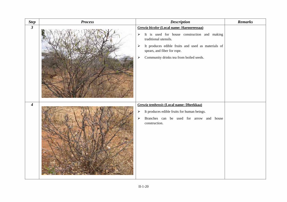
Step Process Description Remarks 3 Grewia bicolor (Local name: Harooreessaa)
It is used for house construction and making traditional utensils.
It produces edible fruits and used as materials of spears, and fiber for rope.
Community drinks tea from boiled seeds.
4 Grewia tembensis (Local name: Dheekkaa)
It produces edible fruits for human beings.
Branches can be used for arrow and house construction.

II-1-21
Step Process Description Remarks 5 Grewia villosa (Local name: Ogomdii)
It produces edible fruits during drought time.
Fibers from stems are used for weaving.
6 Pappea capensis (Local name: Biiqaa)
Edible fruit for human beings during drought period.
II-1-22
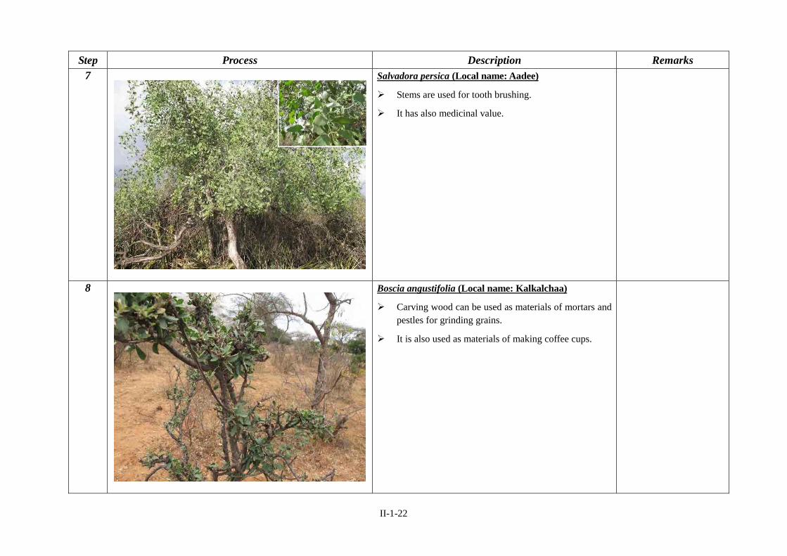
Step Process Description Remarks 7 Salvadora persica (Local name: Aadee)
Stems are used for tooth brushing.
It has also medicinal value.
8 Boscia angustifolia (Local name: Kalkalchaa)
Carving wood can be used as materials of mortars and pestles for grinding grains.
It is also used as materials of making coffee cups.

II-1-23
Step Process Description Remarks 9 Acacia nilotica (Local name: Burquqee)
Stems are used as fire wood and materials of fencing.
Red dyes can be extracted from the bark and black dyes can be extracted from the pod.
10 Rhus natalensi (Local name: Daboobeesaa)
It produces edible fruits for human begins.
It has medicinal value.

II-1-24
Step Process Description Remarks 11 Acacia senegal (Local name: Hidhadhoo)
It produces “Gum Arabic” (like chewing gum).
Stems can be used as fire wood and materials of fencing.
12 Acacia totortilis (Local name: Urbu)
People can cook soup from boiled seeds and pods during drought time.

II-1-25
Step Process Description Remarks 13 Terminalia brownii (Local name: Birreessaa)
It is used for incense fumigation.
Yellow dye is extracted from the bark and used for coloring and painting people’s hand.
Wood can be used for making pestles.
Medicine is extracted from the bark.
It is used as shade tree.
14 Dobera glabra (Local name: Gerse)
People boil the hard seed for food.
It produces edible fruits for human beings.
It is a strong ever green tree used as shade tree.
It has medicinal value.


II-1-26
1.5 Pasture Sowing (General)
Step Materials to be Collected Remarks 0
Seed of grass and legume forages
Manure (Animal dung)
Hand hoe for digging
Sickle for harvesting

II-1-27
Step Process Description Remarks 1 Site Selection for Forage Production
Land should be selected from the areas where no natural grasses are found and is highly degraded bare land.
Flat land is more preferable than slope land because of soil erosion.
Before pasture sowing, bushes, weeds and unwanted plants should be thinned (30% to 50% of plants, not all!).
In case manure is available, it is good if applied.
Forage production is highly sensitive to agro-ecological aspects. (e.g. amount of rainfall, slope or flat land and soil fertility)
2 Land Preparation
Plough the land once or twice. Particularly, a compacted land needs seed bed with minimum tillage. In case the soil is soft, no much cultivation is needed.
In case of slope land, soil bund is helpful to save soils and seed from erosion and washing away.
Areas should be fenced or protected from interference of livestock and wild life.
In case of slope land, total clearing bush is not recommended. Bush also pretends the land from soil erosion and runoff.
It is a good idea that DAs ask every community members to bring one suck of animal manure called “koshi”.

II-1-28
Step Process Description Remarks 3 Applying manure
Ask every community members to bring one sack of animal manure from their Kosi.
A large amount of animal manure should be applied in the sites.
Animal manure should not be fresh. The one kept for some months is better to use. Particularly, it should not be collected from the bottom or top of Kosi. It should be collected from the middle. This is because that the manure should be well-matured.
Apply manure at the rate of 6ton/ha (moderate soil fertility) and 8ton to 10ton/ha (poor moderate).
4 Mixing manure with soil
Mix manure with soil.

II-1-29
Step Process Description Remarks 5 Pasture Sowing
In general, depth of sowing seed should be considered as 3 to 5 times of seed size (e.g. if a seed is 5mm, the depth should be 15mm to 25mm).
2cm is the maximum depth for grass forage. For bigger seeds such as forage legumes, 1.5 to 2cm is enough. Many of seeds will not germinate when the depth is deeper than 3cm.
The left picture shows “sowing grass forage seed” such as Buffel grass and Rhodes grass. At the level of knee, you can spread seed.
The way to sow grass seed is similar to “Teff”. On the other hand, the way to sow legume forage is similar to “Haricot Beans”. Most people may know how to plant Teff and Haricot Beans in Borena. Don’t hesitate to sow pasture seed.
6 Pasture Sowing
The left picture shows “sowing legume forage seed” such as cow pea and lablab. Drop a seed one by one at the level of ground.
Seed rate differs according to the types of forage (e.g. grass forage, legume forage, and fodder tree). Please check the rate for each forage species as a following section explains. However, in general, too much seed rate suppresses the growth of forage. Therefore, low seed rate is more preferable than high seed rate.
Seedbed for legume forage needs to be ploughed more than that for grass forage.
To minimize problems of too much seed sowing in small areas, we can mix the seed with animal dung, soil and sand.

II-1-30
Step Process Description Remarks 7 Covering Seed by Soil
Cover the sown seed by using broom or cleared bushes.
Amount of soil to be covered depends on the appropriate soil depth for each forage variety. In case of grass seed, the seed should be slightly covered by soil or be mixed with soil and broadcasted.
In case of legume forage, cover the seed more carefully than grass forage.
It is also recommended to specify the date for sowing specific pasture seeds (e.g. Rhodes grass is sown on Friday and Pigeon pea is sown on Saturday). This is because beginners often are confused about the difference of the seed rate to be applied.
This allows people to apply proper seed rate for sowing specific forage species.
8 Compressing the Land
It is also good practice that people let cattle through the areas where they sown the grass forage seed.
This saves the grass seed from being washed away by intensive rainfall.

II-1-31
Step Process Description Remarks 9 Compressing the Land
Step on the land where people sown the seed by people’s foot.