s hurricane - weather · julia karl lisa matthew nicole otto paula richard shary tomas ... tropical...
TRANSCRIPT

wea
ther.g
ov/lakecharles
THE OFFICIAL Louisiana2 0 1 02 0 1 0
Alex Bonnie Colin Danielle Earl Fiona GastonHermineIgorJulia Karl Lisa Matthew Nicole Otto Paula Richard Shary Tomas Virginie Walter
S O U T H W E S T L O U I S I A N A E D I T I O N
H u r r i c a n e
Fellow Citizens of Southwest Louisiana,
On behalf of the National Weather Service in Lake Charles, I am pleased to present The Official Louisiana Hurricane Guide - Southwest Louisiana Edition. This guide will provide you with excellent resources as you prepare for the 2010 hurricane season. Besides providing historical documentation on past hurricanes that have affected the region, information on the various hurricane hazards will be provided. Essential tracking charts and evacuation maps are also provided for your reference.
In August and September of 2008, hurricanes Gustav and Ike affected a large part of Louisiana. Gustav brought significant storm surge and winds to south central and southeast Louisiana. Also, Gustav brought over 20 inches of rain to parts of central Louisiana. Although Hurricane Ike moved inland over Galveston Island, significant storm surge flooding was observed across nearly all of coastal Louisiana. As we reflect on the impacts of these hurricanes, let us take this opportunity to develop our own hurricane plan.
This collaborative Hurricane Guide will serve as your roadmap for action before and during a hurricane and will also act as an instructional guide for recovery, continuity and resiliency after the storm passes. It is important to plan accordingly to meet your personal, family and business needs. In this manner, we are all working together for safer and better prepared communities across Louisiana. Working together, we can safeguard lives and protect property by taking the appropriate measures and precautions outlined in this Hurricane Guide.
Sincerely,
Andy Patrick - Meteorologist in ChargeNational Weather Service - Lake Charles, LA
IntroductionIndex of Pages
Storm SurgePages 4-7
Winds, Flooding, and TornadoesPages 8-9
Preparing Your Home, Business, and BoatPages 10-11
Special Needs and PetsPage 12
Emergency Contacts and Your Disaster Supply KitPage 13
Insurance InformationPage 14
Hurricane Tracking MapPages 16-17
EvacuationPage 24-25
Emergency InformationPage 27
Returning HomePages 28-29
Front Cover Design By:Cynthia Ostrowski

Left: High resolution satellite image of Hurricane Ike over the northwest Gulf of Mexico. Image--NASA
Right: Historical perspective of all tropical storm and hurricane landfalls in Louisiana since 1851.
About the HurricaneThe Atlantic hurricane season begins June 1st, and lasts through November 30th. Tropical storm and hurricane formation increases significantly by August, with the peak of the season usually reached on September 10th. Activity begins to decline significantly towards the end of October. The peak threat for the Louisiana coast exists from August to the middle of October. The earliest tropical storm to strike the region was May 30, 1959, with the latest being Hurricane Juan on October 29, 1985; both coming ashore in South Central Louisiana.
Since 1851, there have been 54 hurricanes to strike the Louisiana coast. That is one every three years on average.
Definitions to Know
LTROPICAL DEPRESSION: An organized system of persistent clouds and thunderstorms with a closed low-level circulation and maximum winds of 38 mph or less.
TROPICAL CYCLONE: A general term used to describe a tropical depression, tropical storm, or hurricane.
TROPICAL STORM: An organized system of strong thunderstorms with a well defined circulation and maximum sustained winds of 39 to 73 mph.
HURRICANE: An intense tropical weather system with a well defined circulation and sustained winds of 74 mph or higher.
HURRICANE/TROPICAL STORM WATCH: Hurricane or Tropical Storm conditions are possible in the watch area within 48 hours.
HURRICANE/TROPICAL STORM WARNING: Hurricane or Tropical Storm conditions are possible in the warning area within 36 hours.
Storm Surge
1a 1b
2a 2b
4
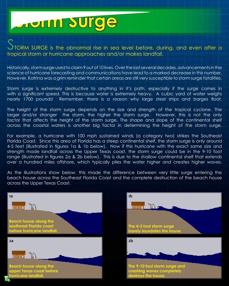
STORM SURGE is the abnormal rise in sea level before, during, and even after a tropical storm or hurricane approaches and/or makes landfall.
Historically, storm surge used to claim 9 out of 10 lives. Over the last several decades, advancements in the science of hurricane forecasting and communications have lead to a marked decrease in this number. However, Katrina was a grim reminder that certain areas are still very susceptible to storm surge fatalities.
Storm surge is extremely destructive to anything in it’s path, especially if the surge comes in with a significant speed. This is because water is extremely heavy. A cubic yard of water weighs nearly 1700 pounds! Remember, there is a reason why large steel ships and barges float.
The height of the storm surge depends on the size and strength of the tropical cyclone. The larger and/or stronger the storm, the higher the storm surge. However, this is not the only factor that affects the height of the storm surge. The shape and slope of the continental shelf across the coastal waters is another big factor in determining the height of the storm surge.
For example, a hurricane with 100 mph sustained winds (a category two) strikes the Southeast Florida Coast. Since this area of Florida has a steep continental shelf, the storm surge is only around 4-5 feet (illustrated in figures 1a & 1b below). Now if this hurricane with the exact same size and strength made landfall across the Upper Texas coast, the storm surge could be in the 9-10 foot range (illustrated in figures 2a & 2b below). This is due to the shallow continental shelf that extends over a hundred miles offshore, which typically piles the water higher and creates higher waves.
As the illustrations show below, this made the difference between very little surge entering the beach house across the Southeast Florida Coast and the complete destruction of the beach house across the Upper Texas Coast.
Beach house along thesoutheast Florida coast before hurricane landfall.
The 4-5 foot storm surgebarely inundates the house.
Beach house along theupper Texas coast beforehurricane landfall.
The 9-10 foot storm surge andcrashing waves completely destroys the house.

Storm Surge
Hurricane Ike will long be remembered as one of the most devastating storm surge hurricanes to affect the Upper Texas and Louisiana coasts within the last 150 years of records. Over the warm waters of the Gulf of Mexico, Ike grew in size and intensified to a category two hurricane with maximum winds of 100 mph. Although Ike’s intensity remained in the category 2 range, the cyclone continued to grow and became a very large and dangerous hurricane. Aircraft Reconnaissance measured Ike’s tropical storm wind swath to be approximately 450 miles wide, with a hurricane force wind swath of 180 miles. Hours before landfall, Ike’s structure began getting better organized with an eye evident. Ike made landfall on Galveston Island at 2:00 AM CDT September 13th as a strong category 2 based on 110 mph sustained winds and a central pressure of 950 mb.
The combination of Ike’s large wind swath, and the fact that this wind swath piled water over the shallowest portion of the Gulf, lead to much higher than normal storm surge flooding along the Upper Texas and Louisiana Coasts. Storm surge levels ranged between 14 and 18 feet across most of Southern Jefferson county. The 14 foot storm surge at Sabine Pass resulted in the highest water level ever record at that location. Further east along the Louisiana coast, storm surge values of 12 to 16 feet across western Cameron parish was slightly higher than that observed during Rita only three years earlier. Across eastern Cameron, Vermilion, Iberia, and St. Mary parishes, storm surge values ranged between 8 and 12 feet. Any structure that was not elevated was destroyed. Even homes that were elevated received water damage due to high waves on top of the storm surge.
Ike’s storm surge devastated many communities along the Louisiana coast, which was still trying to rebuild after Hurricane Rita only three years earlier.
5
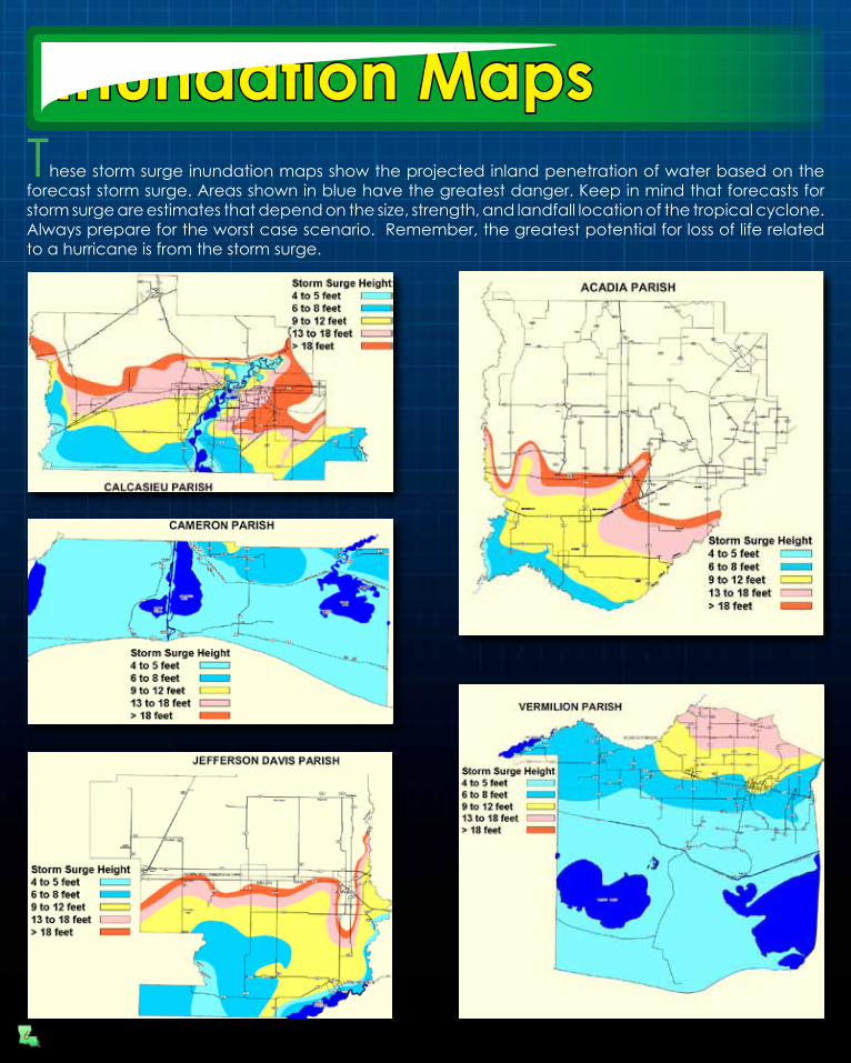
Inundation MapsThese storm surge inundation maps show the projected inland penetration of water based on the forecast storm surge. Areas shown in blue have the greatest danger. Keep in mind that forecasts for storm surge are estimates that depend on the size, strength, and landfall location of the tropical cyclone. Always prepare for the worst case scenario. Remember, the greatest potential for loss of life related to a hurricane is from the storm surge.
6

Inundation Maps
For more detailed parish and county storm surge maps in .pdf format, go to the following website:
www.srh.weather.gov/lch/tropical/StormSurgeMaps.php
7
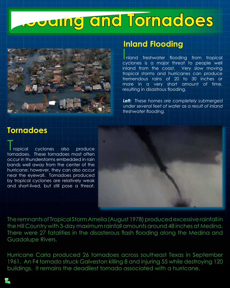
Inland FloodingInland freshwater flooding from tropical cyclones is a major threat to people well inland from the coast. Very slow moving tropical storms and hurricanes can produce tremendous rains of 20 to 30 inches or more in a very short amount of time,resulting in disastrous flooding.
Left: These homes are completely submerged under several feet of water as a result of inland freshwater flooding.
Tornadoes
Tropical cyclones also produce tornadoes. These tornadoes most often occur in thunderstorms embedded in rain bands well away from the center of the hurricane; however, they can also occur near the eyewall. Tornadoes produced by tropical cyclones are relatively weak and short-lived, but still pose a threat.
The remnants of Tropical Storm Amelia (August 1978) produced excessive rainfall in the Hill Country with 3-day maximum rainfall amounts around 48 inches at Medina. There were 27 fatalities in the disasterous flash flooding along the Medina and Guadalupe Rivers.
Hurricane Carla produced 26 tornadoes across southeast Texas in September 1961. An F4 tornado struck Galveston killing 8 and injuring 55 while destroying 120 buildings. It remains the deadliest tornado associated with a hurricane.
Flooding and Tornadoes
8

Hurricane force winds of 74 mph or more can destroy buildings, mobile homes, trees and power poles. Debris such as signs, roofing material, siding, and small items left outside become flying missiles in a hurricane. The strongest winds occur in a region of the hurricane called the eyewall. Wind gusts in the right side of the eyewall are the most destructive. Hurricane force winds can be felt as far as 150 miles from the coast.
It is imperative to ensure your home or business is well constructed to minimize the damage from the wind. See the Planning and Preparing section in this guide for cost effective home improvement tips that can help you reduce your damage from a hurricane.
This large piece of plywood was driven through the trunk of a palm tree during the fierce winds of Hurricane Andrew in south Florida in 1992.
! MOBILE HOME RESIDENTS MUST EVACUATE!No mobile home or manufactured home - no matter how new it is - can provide safe shelter from hurricane force winds.
Straps or other tie-downs will not protect a mobile home from the high winds associated with a hurricane.
Mobile home residents must evacuate when told to do so by local authorities.
Saffir Simpson Hurricane Wind ScaleCategory 1
Category 2
Category 3
Category 4
Category 5
Winds 74 to 95 mph
Winds 96 to 110 mph
Winds 111 to 130 mph
Winds 131 to 155 mph
Winds greater than 155 mph
Destructive Winds
9
Preparing Your Home Before the Storm
Proper hurricane preparations made ahead of time will not completely protect your property from damage. However, following a few simple tips may greatly reduce the damage to your home and property.
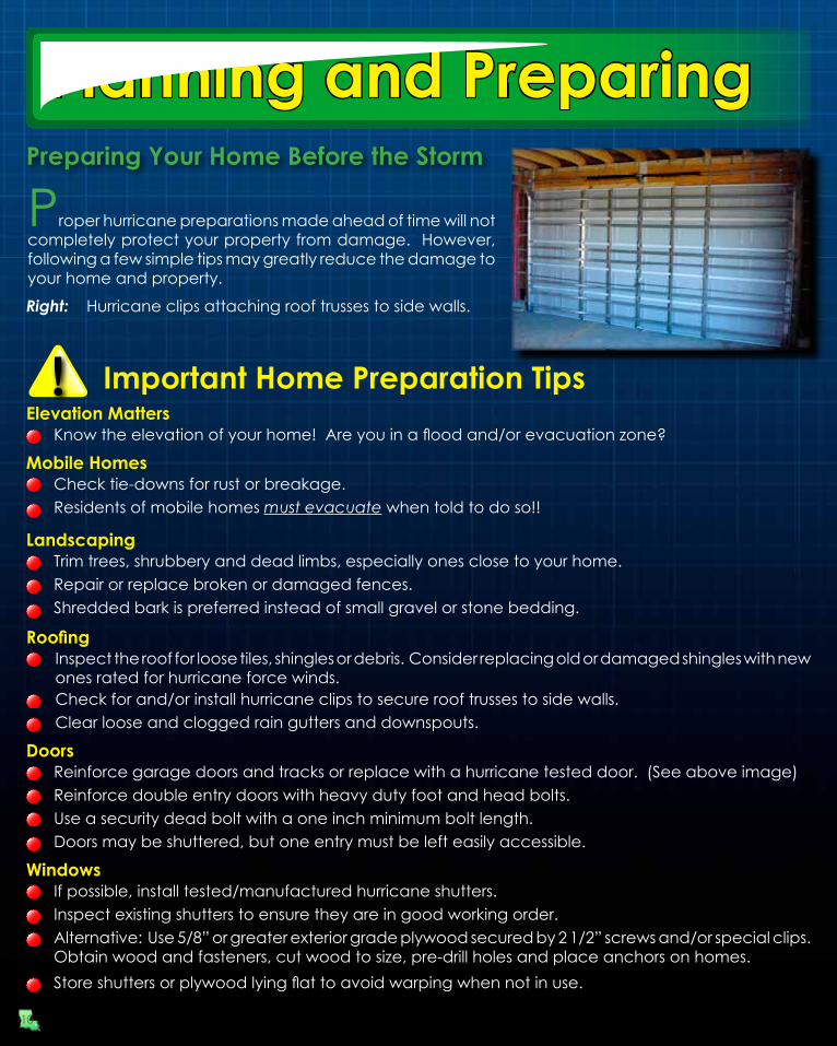
Right: Hurricane clips attaching roof trusses to side walls.
! Important Home Preparation Tips
Mobile HomesCheck tie-downs for rust or breakage.Residents of mobile homes must evacuate when told to do so!!
Know the elevation of your home! Are you in a flood and/or evacuation zone?Elevation Matters
LandscapingTrim trees, shrubbery and dead limbs, especially ones close to your home.Repair or replace broken or damaged fences.Shredded bark is preferred instead of small gravel or stone bedding.
RoofingInspect the roof for loose tiles, shingles or debris. Consider replacing old or damaged shingles with new ones rated for hurricane force winds.Check for and/or install hurricane clips to secure roof trusses to side walls. Clear loose and clogged rain gutters and downspouts.
DoorsReinforce garage doors and tracks or replace with a hurricane tested door. (See above image)Reinforce double entry doors with heavy duty foot and head bolts.Use a security dead bolt with a one inch minimum bolt length.Doors may be shuttered, but one entry must be left easily accessible.
WindowsIf possible, install tested/manufactured hurricane shutters.Inspect existing shutters to ensure they are in good working order.Alternative: Use 5/8” or greater exterior grade plywood secured by 2 1/2” screws and/or special clips. Obtain wood and fasteners, cut wood to size, pre-drill holes and place anchors on homes.Store shutters or plywood lying flat to avoid warping when not in use.
Planning and Preparing
10

Tips for BusinessesIdentify and protect vital records. Backup and store key files off site.
Protect electronic equipment from possible water damage.
Have extra cash and blank checks in case extra money is needed after the storm.
Establish a temporary location for business operations in case your facility is damaged.
Identify a safe room for employees who must remain in the building.
Give employees enough time to secure their homes and families.
Develop a 24-hour emergency contact with phone numbers of key employees.
Consider paying employees before they leave to prepare their homes.
Set up telephone numbers for employees to check in and receive company information.
Protecting Your Boat - Marine Preparations
Tips for Boat OwnersCheck your marina contract for policies and procedures for hurricanes.Check with the manufacturer for proper ways to secure your boat during a storm.
Consider moving arrangements well in advance of an approaching storm.
Trailer boats should be removed from the water and securely stored at least 48 hours before a hurricane is expected to make landfall.
Purchase necessary hurricane materials such as additional mooring lines, crew anchors, fenders, fender boards, chafing gear, and anchors.
Safe storm moorings should consist of good condition ropes of sufficient diameter and length, with at least three or four substantial anchor points.Do not moor parallel to bank. Receding tides often each or capsize boats in this type of anchorage.
Planning and PreparingBusiness and Employee Preparation
!
!
11

General Preparations for People With Special Needs
Preparation in advance of hurricane season is essential, especially for people with special needs. It is essential that a destination is identified ahead of time that can accommodate people with special needs. Shelters should be considered as a last resort when people with special needs evacuate because many shelters cannot provide the attention required. Assisting elderly neighbors and acquaintances with pre-hurricane preparations is encouraged.
! Important Special Needs TipsIdentify with whom you will stay in the event an evacuation becomes necessary.
Make sure you have the following items that should be stored in advance:
Make arrangements for transportation in the event you evacuate. Make sure your transportation can accommodate any equipment or other supplies that need to be taken with you.
Extra copies of your prescriptions in case your physician’s office is damaged and not operational.
At least a 1 month supply of medications.
Identification.
Preparing for Your Pet’s Safety
Your pet should be part of your overall hurricane preparation plans. Below are a few important things to help you prepare:
Make sure your pet’s vaccinations are current and have proof they are current. DO NOT assume that a public shelter or hotel will accept your pet.
Be sure to have a current photo of your pet.Each animal should have a properly sized pet carrier. The carrier should be large enough for the animal to stand up and turn around.
Make sure your pet has a proper ID collar.Pack enough food and bottled water for the duration of your evacuation. DO NOT let your pet eat food or drink water from outside that may have become contaminated.Be sure to pack all medications your pet may need along with a muzzle, collar, leash, paper towels, and trash bags.
FEMA News Photo
Special Needs and Pets
12
The American Red Cross of Southwest Louisiana recommends that you have the following items in your Hurricane Supply Kit. Do not forget to have a family meeting before hurricane season and review your communication information and evacuation plan. Make sure the contact information such as home, work, school, cell phone numbers,and your “Out of Town” contact person’s information is current.
Emergency Contact Information
! !HURRICANE SUPPLY KITAt least a 7-day supply of non-perishable food and a manual can opener
CD or photocopies of important documents such as birth/marriage certificates and titles
At least a 7-day supply of water. One gallon per person per day is recommended
Battery powered portable television or radio with extra batteriesFlashlight with extra batteries
First Aid kit and manualSanitation and hygiene items such as instant hand sanitizing gel, moist towelettes, toilet paper, and feminine hygiene products
Matches in a waterproof containerWhistle
Photocopies of identification, insurance, prescriptions, household inventory, credit cards, and your latest utility bill
Prescription medications, eyeglasses, contact lens solution, and hearing aid batteriesFormula, baby food, diapers, and pacifiers
A good map showing county roads and highways
Pet carriers, leashes, shot records, and food for each animal evacuating with you
Tire repair kit, booster cables, pump, and flares
List of family phone numbers and addresses outside the area
White distress flagToys and games for children
Cash
Extra clothing, blankets, and sleeping bags
Kitchen accessories and cooking utensils
Out of Town Contact Address:Out of Town Contact Phone Number:Work Telephone Number:Cell Number/Spouse Cell Number:Children Cell Number:School Telephone Number:Doctor Telephone Number:Bank/Credit Card Telephone Number:Insurance Company Information:
Contact Info/Supply Kit
13

Louisiana Department of Insurancewww.ldi.state.la.us/consumer
!1-800-259-5300 (General Information)
14
Insurance Tips - Before the StormWhen shopping for insurance, get quotes from different companies and consider financial strength and history of complaints from each company.Ask agents for discounts if available.New and existing policies will not be written or modified when a storm nears the Gulf of Mexico.Make sure you fully understand what perils are covered and excluded in your policy.Make sure your coverage is adequate to replace your home and contents in today’s dollar.
DO NOT cancel an old policy until you have a new policy in effect.Before hurricane season, prepare detailed written and/or photographic inventory of your home’s contents and store it in a safe place with your policy.
If your insurance company does not cover flood or windstorm perils, ask about coverage through the Texas Windstorm Insurance Association or the National Flood Insurance Program.
Important Web InformationNational Flood Insurance Program
www.floodsmart.gov
Insurance Tips - After the StormGive prompt written notice to your insurance company.If you cannot be easily contacted, give your insurance company the contact information of a trusted friend or relative who can reach you if necessary.Photograph or videotape damaged structures and all maged property. Make a list of damaged or lost items.DO NOT throw out damaged property before your adjuster has inspected the debris unless it is a health hazard or impedes local cleanup.Protect your property from further damage.Keep an accurate record of temporary repair and living expenses if a loss of use is suffered.
Payment advancements are made to policy holder for home repairs, personal property and living expenses. Final payments are made only after completed repairs and adjuster review.
Along with insurance adjuster estimate for repairs to home, obtain two or more contractor estimates.Estimates must be broken down per line item.
Insurance Tips
If you evacuate or choose to leave your home for safety, make sure to take the written and photo inventory with you, as well as all insurance policies (auto, home, life, etc.)
Determine whether your policy covers additional living expenses for a temporary residence if you are unable to live in your home because of damage from a disaster.

Hurricane Ike (September 12-13, 2008): Very large category two hurricane that made landfall at Galveston Texas. Storm surge values were 12-16 feet across western Cameron parish, which was slightly higher than that observed during Rita only three years earlier. Across eastern Cameron, Vermilion, Iberia, and St. Mary parishes, storm surge values ranged between 8-12 feet.
Hurricane Humberto (September 12-13, 2007): Very small category one hurricane that made landfall between High Island and Sea Rim State Park in Jefferson county, Texas. Due to the small size, storm surge values were only 3-4 feet across central and western Cameron parish.Hurricane Rita (September 23-24, 2005): Very large category three hurricane that made landfall between Johnson’s Bayou and Sabine Pass, affected most of Southwest Louisiana and Southeast Texas with hurricane force winds. Storm surge values across Southwest Louisiana were 12-18 feet across most of Cameron parish, and 10-12 feet across most of Vermilion parish, which was the worst storm surge flooding recorded during the last 150+ years of record keeping.Hurricane Lili (October 3, 2002): Category one hurricane that made landfall at Intracoastal City in Vermilion Parish. Storm surge values were 10-12 feet across Iberia and St. Mary parishes.Hurricane Andrew (August 26, 1992): Category three hurricane that made landfall west-southwest of Morgan City in St. Mary parish. Storm surge values were around 8 feet across Iberia and St. Mary parishes, which were lower than expected due to Andrew paralleling the coast at landfall.Hurricane Bonnie (June 26, 1986): Very small category one hurricane that made landfall between High Island and Sea Rim State Park in Jefferson County. Storm surge values were 3-4 feet across central and western Cameron Parish.
Hurricane Juan (October 28-30, 1985): Very large hybrid-type category one hurricane which approached Vermilion parish on the 28th but stayed offshore to make a cyclonic loop, eventually making landfall in St. Mary parish. Juan made another cyclonic loop inland across South Central Louisiana, moving offshore to affect Southeast Louisiana and the Florida Panhandle. Storm surge values fluctuated between 3-6 feet across Vermilion, Iberia, and St. Mary parishes.Hurricane Danny (August 15, 1985): Category one hurricane that made landfall between Grand Chenier in Cameron parish and Pecan Island in Vermilion parish.Storm surge values ranged 5-8 feet across Vermilion, Iberia, and St. Mary parishes.Hurricane Carmen (September 8, 1974): Category three hurricane that made landfall across St. Mary parish, spread category two conditions across Iberia parish, with category one conditions across Vermilion, Lafayette and Acadia parishes. Storm surge ranged 4-6 feet across Iberia and St. Mary parishes.
Hurricane Gustav (September 1, 2008): Large category two hurricane that made landfall across Terrebonne parish in Southeast Louisiana, but continued northwest across the Atchafalaya Basin, spreading category one hurricane force winds across South Central Louisiana. Due to the storm making landfall east of the region, storm surge values were only 4-5 feet across St. Mary, Iberia, and Vermilion parishes.
Hurricane Edith (September 16, 1971): Category two hurricane at landfall across Cameron and Vermilion parishes, and spread category one conditions across Iberia, St Mary, Lafayette, Acadia, and St. Martin Parishes. Storm surge values of 6 feet at Sabine Pass, with 8+ feet across Cameron and Vermilion parishes.
Hurricane Audrey (June 26-27, 1957): Very large and deadly category four hurricane, with a 40 mile wide eye, made landfall from Sabine Pass to Cameron, and affected most of Southwest Louisiana and Southeast Texas with hurricane force winds. Storm surge values of 10-14 feet occurred across most of Cameron Parish, and 7-10 feet across Vermilion, Iberia, and St. Mary Parishes. Unfortunately, over 500 direct fatalities was attributed to Audrey, mainly across Cameron and Vermilion parishes due to storm surge.
15
Hurricane Hilda (October 3-4, 1964): Category three hurricane at landfall across St. Mary parish, where 6+ foot storm surge occurred at the Atchafalaya River. Farther west, storm surge ranged between 3-5 feet across Iberia and Vermillion parishes.
Hurricane Carla (September 10-12, 1961): Extremely large category four hurricane (circulation covered the entire Gulf of Mexico at one point) made landfall across the central Texas coast. Due to the large size of the storm, storm surge values of 7-8 feet were common across Southwest Louisiana.
Additional hurricane history can be obtained at:www.srh.weather.gov/lch/?n=tropic
Hurricane History

16

17

Hurricane Forecasts
18
Don’t Focus on the Skinny Black Line!!Weather forecasting has never been and will likely never be an exact science. Thus, the ability to forecast the exact track and intensity of a hurricane will always present a challenge for forecasters and users of the forecasts to make critical evacuation decisions. In the figure below, the “skinny black line” represents the forecast track of highest confidence. However, one must not just focus on the skinny black line, but rather focus on the potential area the hurricane could affect, as illustrated by the white and hatched areas around the forecast track. This area, known as the “cone of uncertainty,” represents the average track errors during the last five years. Fortunately, track forecasting has improved over the last several decades. Unfortunately, intensity forecasting has not shown much increase in accuracy over the same time period.
The forecast graphic above illustrates why users of the hurricane forecast must take into consideration the “cone of uncertainty.”

19
Listen frequently to radio, TV, or NOAA weather radio for bulletins and forecasts of the storm’s progress.Double check items in your emergency supply kit.Fuel and service your vehicles.Inspect and secure mobile home tie-downs.Make sure you have supplies to survive on your own for at least one week if you plan on staying.Board up windows (if shutters do not exist) in case storm moves quickly and you have to leave. TAPE PROVIDES NO PROTECTION!Store lawn furniture and other loose, light weight objects, such as garbage cans and garden tools.Get plenty of extra cash in case power goes out and ATMs do not work.Garage or store vehicles that are not being used.Follow instructions issued by local officials. EVACUATE IMMEDIATELY IF ORDERED TO DO SO!
Turn off propane tanks.Unplug small appliances.Empty refrigerator and freezer.Turn off utilities if ordered to do so.Notify family members of your evacuation plans.Lower water level in swimming pool by one foot.Lock home securely.Board up remaining doors and brace garage door.Take pets with you.
Close storm shutters.Turn refrigerator or freezer to coldest setting and open only if necessary.(25 pounds of dry ice will keep a 10-cubic foot freezer below freezing for 3-4 days.)Follow instructions from emergency managers and be prepared to turn off utilities if ordered to do so.Board up remaining doors, brace garage door, and remain inside. Stay away from boarded up windows.Take refuge in a predetermined safe room, such as an interior closet, bathroom, or hallway.Beware of the calm winds in the eye of the storm and do not venture outside. Some of the strongest winds may occur shortly after the eye passes.DO NOT EXPECT EMERGENCY RESPONDERS TO BE OF ANY ASSISTANCE DURING A LANDFALLING HURRICANE!
Actions to Take When a Storm is in the Gulf
Final Actions to Take if Leaving
Final Actions to Take if Staying
Final Checklists
Hurricane Ike (2008)
Hurricane Ike was a long lived tropical cyclone that originated from a well defined tropical wave which moved off of the western African coast on August 28, 2008. Bursts of convection associated with a developing area of low pressure occurred along the wave axis for the next several days; however, it was not estimated to be a tropical depression until 1:00 AM CDT on September 1st, 775 miles west of the Cape Verde Islands. The depression continued to become better organized and quickly strengthened to become tropical storm Ike later that day. Moving west-northwest, Ike continued to strengthen and became a hurricane early on the afternoon of September 3rd, when an eye became apparent on satellite imagery. Rapidly intensifying, Ike reached a maximum intensity of 145 MPH
Track and Intensity
on Thursday, September 4th. A building upper level high to Ike’s north induced a west and then west-southwest motion beginning on September 4th, and continuing through the 7th. During this period, Ike impacted the Turks and Caicos Islands, and moved across the island of Great Inagua. By late on the 7th (Sunday evening), Ike made the first of two landfalls along the Cuban coast near Cabo Lucrecia with maximum winds around 130 MPH. After moving off and paralleling the Cuban coastline, Ike made a second landfall near the city of San Cristóbal. Just prior to crossing the northwest tip of Cuba as a category one hurricane, with winds close to 80 MPH, Ike began producing tropical storm force winds across portions of the Florida Keys on Tuesday morning, September 9th. Fortunately for the Keys, Ike only delivered a glancing blow, as the hurricane continued to move west-northwest toward the U.S. Gulf coast.
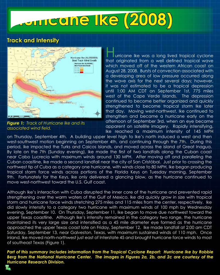
Although Ike’s interaction with Cuba disrupted the inner core of the hurricane and prevented rapid strengthening over the warm waters of the Gulf of Mexico, Ike did quickly grow in size with tropical storm and hurricane force winds stretching 275 miles and 115 miles from the center, respectively. Ike did slowly intensify to a category two hurricane with maximum winds of 100 mph by Wednesday evening, September 10. On Thursday, September 11, Ike began to move due northwest toward the upper Texas coastline. Although Ike’s intensity remained in the category two range, the hurricane maintained its very large size and intensified as a 45 mile diameter eye formed as the hurricane approached the upper Texas coast late on Friday, September 12. Ike made landfall at 2:00 am CDT Saturday, September 13, near Galveston, Texas, with maximum sustained winds of 110 mph. Once inland, Ike moved north-northwest just east of Interstate 45 and brought hurricane force winds to most of southeast Texas (Figure 1).
Figure 1: Track of Hurricane Ike and its associated wind field.
Part of this summary includes information from the Tropical Cyclone Report: Hurricane Ike by Robbie Berg from the National Hurricane Center. The images in Figures 2a, 2b, and 2c are courtesy of the Hurricane Research Division.
20

Hurricane Ike (2008)Size and Surge
Figure 2a: Maximum 1-minute sustained wind speeds associated with Hurricane Ike on September 13, 2008
Figure 2b: Maximum 1-minute sustained wind speeds associated with Hurricane Alicia on August 18, 1983
Figure 2c: Maximum 1-minute sustained wind speeds associated with Hurricane Carla on September 12, 1961
For residents of southeast Texas, Ike will forever be remembered for its large size and significant storm surge. Although just under the wind speed criteria for a major hurricane (115 MPH or greater), Ike produced the greatest storm surge along the Texas coast since hurricane Carla (Category four) made landfall near Port Lavaca in 1961. Interestingly, although Ike was considerably weaker than Carla as far as maximum wind speeds are concerned, the tropical cyclone did have a larger area of hurricane force winds at landfall and a comparable tropical storm force wind field. Therefore, from a total energy standpoint, Ike was very similar to Carla; and, that explains why the magnitude of the surge events was similar. Ike produced a greater storm surge than that produced by hurricane Alicia (1983), which was southeast Texas’ last major landfalling hurricane. Ike was approximately four times larger than Alicia when comparing the size of the hurricane force wind fields. See Figure 2a, 2b, and 2c for a size comparison of these tropical cyclones’ wind fields near landfall.
21
Rip Current Safety
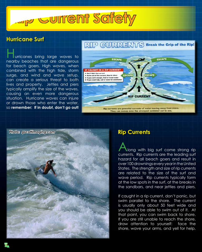
Hurricanes bring large waves to nearby beaches that are dangerous for beach goers. High waves, when combined with the high tide, storm surge, and wind and wave setup, can create a serious threat to both lives and property. Jetties and piers typically amplify the size of the waves, causing an even more dangerous situation. Hurricane waves can injure or drown those who enter the water, so remember: If in doubt, don’t go out!
Hurricane Surf
Rip Currents
Along with big surf come strong rip currents. Rip currents are the leading surf hazard for all beach goers and result in over 100 drownings every year in the United States. The strength and size of rip currents are related to the size of the surf and wave period. Rip currents typically form at the low spots in the surf, at the breaks in the sandbars, and near jetties and piers.
If caught in a rip current, don’t panic, but swim parallel to the shore. The current is usually only about 50 feet wide and you should be able to swim out of it. At that point, you can swim back to shore. If you are still unable to reach the shore, draw attention to yourself: face the shore, wave your arms, and yell for help.
Photo: gscottimaging.com
22

Assure that all contact information and emergency contact information is accurate with your campus’s registrar’s office.
If your campus offers an emergency management communication system, register as a user of the system.
Plan your method of evacuation and your destination before a storm enters the gulf.Monitor local radio and TV stations for updates.Contact your campus Student Affairs Office if you need assistance with evacuation.If you require any assistance due to a disability-related accommodation, please contact your campus Disability Services Office to make necessary arrangements.
Communicate with your family regarding status and location
If your campus is evacuating, you will not be allowed to remain on-campus and it is highly recommended that you leave the city. Do not go to a coastal location.
Take your driver’s license, student I.D. card, and a copy of your housing lease as well as medical insurance cards and other important documents when you evacuate.
If you bank with a local bank or credit union whose infrastructure may be damaged by the storm, withdraw some funds as you may not have access to them once you leave the area.
International students must take passports with US student visa inside, I-20, I-94, student I.D. and class schedule.If using personal transportation, take as many of your valuable or irreplaceable items as you are able.
If driving, make sure all roads that you are driving are open and safe. You can call the Department of Transportation at 1-888-762-3511 or check Louisiana road conditions at www.dotd.state.la.us
Follow baggage limits if participating in an assisted evacuation program.
Take a 30-day supply of medications in original pharmacy containers.Make a record of any valuables left behind (description, serial numbers, etc). Take pictures of all belongings.If you are evacuating to a shelter, make appropriate arrangements for pets. Most shelters do not accept pets.
Do not plan to return to campus until an all-clear is given (monitor media and campus web-site).
Unplug all electronics and cover them in plastic
Shut and lock your window and close your blinds
Store items off the floor and away from windows
Take all items off balconies and out of yards
Empty refrigerator
Take valuables
Follow any additional instructions by your landlord
College Student PreparationStudent Information Checklist
Preparing Your Room
23

ORANGE
Phased Evacuation
During a threat of a hurricane, a phased evacuation will be based on geographic location and time in which tropical storm winds are forecasted to reach the affected areas.
Phased evacuation procedures are for traffic management purposes only. Consult your local Office of Emergency PreparednessDirector for further evacuation information.
Phase III - 30 Hours before onset of tropical storm winds. Includes areas on the East Bank of the Mississippi River in the New Orleans M etropolitan Area which are within the levee protection system but remain vulnerable to a slow-moving Category 3 or any Category 4 or 5 storm. These areas are depicted in YE LLOW on the Evacuation M ap. During Phase III, certain routes will be directed and the Contraflow Plan implemented.Phase II - 40 H ours before onset of tropical storm winds. Includes areas south of the M ississippi River w hich
are levee protected but remain vulnerable to Category 2 or higher storms. These areas are depicted in on the Evacuation Map. During Phase II there are no route restrictions.
Phase I - 50 H ours before onset of tropical storm winds. Includes areas south of the Intracoastal Waterway. These areas are outside any levee protection system and are vulnerable to Category 1 and 2 storms. T hese areas are depicted in RED on the Evacuation M ap. During Phase I there are no route restrictions.
59
59
110
55
20
84
49
98
49
49E
51
61
11
84
165
84
171
171
80
165
51
80
8080
10
49
20
Texas
Mississippi
11
90
98
84
45
49
61
51
61
61
19012
12
11
10
10
90
55
84
80
71
190
190
190
90
167
21
41
4639
3923
23
45
1
5557
56
24
20
182
1
1
70
182
25
16
67
19
1
28
28
8
1326113
26
99
27
109
12
12
339
31
333
8235
13
14
82
101
14
2727
82
6
1
1
1
3
2
147
34
15
17
17133
65
65
43
449
16
90
21
90
167
3127
3235
1
220
10
55
2
716
79
10
2
Vernon
Winn
Cameron
Rapides
Hinds
Union
Allen
Yazoo
Sabine
Vermilion
Caddo
Amite
Newton
Perry
Jones
Scott
Grant
Bossier
Rankin
LaFourche
Copiah
Calcasieu
De Soto Smith
Jasper
Terrebonne
Jasper
Natchitoches
Beauregard
Bienville
Acadia
Leake
Pike
Iberia
Tensas
Avoyelles
St. Landry
Warren
Madison
Plaquemines
Sabine
Iberville
St. Mary
Lincoln
La Salle
Claiborne
Franklin
Marion Lamar
Stone
Newton
Pearl River
Madison
Webster
Catahoula
Wilkinson
Concordia
Morehouse
Ouachita
Franklin
Jackson
Harrison
Clarke
Simpson
Tangipahoa
Livingston
Wayne
Adams
Forrest
Lincoln
St. Tammany
Neshoba
Richland
Caldwell
St. Martin
Evangeline
Washington
Kemper
Jefferson
Hancock
Shelby
Walthall
Claiborne
Orange
Sharkey
Lawrence
Jefferson Davis
Issaquena
Covington
Red River
Pointe Coupee
Greene
St. Helena
Lauderdale
East Carroll
St. Bernard
Jefferson
Attala
St. Charles
East Feliciana
Assumption
Jackson
Ascension
West Carroll
Lafayette
West Feliciana
Jefferson
Orleans
Jefferson Davis
East Baton Rouge
George
St. James
St. Martin
Iberia
Holmes WinstonHumphreys
NoxubeeUnion
St. John the Baptist
Panola
Ashley
West Baton Rouge
Harrison
San Augustine
Cass
Columbia ChicotLafayetteMiller Washington
Tyler
Tyler
84
167
90
171
165
71
65
371
61
425
190
79
63
90
71
165
167
79
65
84
167
84
90
84
167
165
371
65
171
190
167
190
49
20
10
55
59
310
510
220
210
110
610
20
LOUISIANA EMERGENCY EVACUATION MAP
Natchez
Vicksburg
Jackson
Hattiesburg
Meridian
0 10 20 30 405Miles
Gulfport
Monroe
Shreveport
Alexandria
Lake Charles LafayetteBaton Rouge
Houma
New Orleans
SlidellCovington
2
Gulf
ofMexico
LEGEND
Urban Areas
Intracoastal WaterwayMississippi River
US HighwaysInterstate Highways
10 Interstate Highway Shield
US Highway Shield61
1 Shelter Information Points
State Highway Shield1
Mississippi State Highways
Parishes/Counties
Louisiana Evacuation Routes
2
1
6
5
37
48
24
Evacuation
Alle
nPa
rish
Cal
casi
euPa
rish
Beau
rega
rdPa
rish
Acad
iaPa
rish
St. L
andr
yPa
rish
Jeffe
rson
Dav
isPa
rish
Lafa
yette
Paris
h
Ray
ne
Euni
ce
Sulp
hur
Cro
wle
y
Wes
tlake
Jenn
ings
Car
encr
o
Ope
lous
as Lafa
yette
De
Qui
ncy
Lake
Cha
rles
Brea
ux B
ridge
Iow
a
Iota
Wel
sh
Scot
t
Mam
ou
Elto
n
Vint
on
Suns
et
Kind
erBa
sile
Obe
rlin
Leon
ville Br
ouss
ard
Was
hing
ton
Port
Barre Arna
udvi
lle
Ville
Pla
tte
Gra
nd C
otea
uC
hurc
h P
oint
10
210
49
10
165
171
90
90
10
49
90
190
190
167
71
167
14
27
13
10
10
27
12
3
4
To Shreveport
To Alexandria
To Alexandria
Wes
tbou
nd I
-10
Ope
n fo
r Lo
cal T
raffic
Exit
25Cl
osed
Exit
33Cl
osed
Exit
34Cl
osed
Exit
44O
pen
to c
ontr
aflo
wtr
affic
onl
y.
Exit
19Ea
stbo
und
190
Ope
nW
estb
ound
190
Clo
sed
Exit
18O
pen
Exit
11O
penEx
it 23
Ope
n to
cont
raflo
w la
nes
10
210
90
171
90
210
10
10
14
165
165 10
10Fron
tage
Roa
d
10
10
49
49
10
49
10
49
Sout
hwes
t Lou
isia
na C
ontra
flow
Pla
n
I-10
@ U
S 16
5In
terc
hang
eI-1
0 @
I-49
In
terc
hang
e(B
egin
ning
of
Con
traflo
w
on I-
49)
I-49
@ L
A 10
(End
of
Con
traflo
w
on I-
49)
I-210
Eas
t (co
ntra
flow
lane
s) -
To A
lexa
ndria
(PU
RPL
E)
Eas
tbou
nd I-
210
traf
fic w
ill c
ross
ove
r to
the
wes
tbou
nd la
nes
of I-
210
just
bef
ore
(s
outh
of)
US
90.
T
he c
ross
ed-o
ver t
raffi
c w
ill th
en c
ontr
aflo
w (t
rave
l eas
t on
the
wes
tbou
nd la
nes
o
f I-1
0) to
US
165
Nor
th.
T
raffi
c us
ing
the
I-10
cont
raflo
w la
nes
will
be
dive
rted
nor
thbo
und
onto
US
165.
I-210
@ I-
10 E
astb
ound
05
Mile
s
I-10
East
boun
d - T
o A
lexa
ndria
or B
aton
Rou
ge (B
LUE)
I-10
east
boun
d tr
affic
(nor
mal
lane
s) w
ill n
ot b
e al
low
ed to
exi
t at t
he fo
llow
ing
exits
:
Exi
t 25,
I-21
0 Ea
st
Exi
t 33,
US
171
E
xit 3
4, I-
210
Wes
t
Exi
t 44,
US
165
A
ll ot
her e
xits
alo
ng I-
10 w
ill b
e op
en.
I
-10
east
boun
d la
nes
will
flow
as
norm
al to
Laf
ayet
te th
roug
h th
e La
ke C
harle
s ar
ea.
Lake
Cha
rles
Area
Inst
ruct
ions
Lafa
yette
Are
a In
stru
ctio
nsI-1
0 Ea
st a
nd W
est -
To
Ale
xand
ria o
r Bat
on R
ouge
(BLU
E)
Ea
stbo
und
I-10
traf
fic m
ay c
ontin
ue E
ast o
r tra
vel N
orth
on
I-49.
Wes
tbou
nd I-
10 tr
affic
from
Bat
on R
ouge
will
be
dive
rted
to I-
49 N
orth
if L
ake
Cha
rles
has
begu
n co
ntra
flow
.
US
90 /
US
167
(Eva
ngel
ine
Thw
y) /
I-49
Nor
th (c
ontr
aflo
w la
nes)
- To
Ale
xand
ria/S
hrev
epor
t (R
ED)
Nor
thbo
und
traf
fic o
n U
S 90
/US
167
(Eva
ngel
ine
Thw
y) th
roug
h La
faye
tte
w
ill c
ross
ove
r to
cont
raflo
w la
nes
just
bef
ore
(sou
th o
f) th
e I-1
0/I-4
9 in
terc
hang
e.
N
orth
boun
d tr
affic
on
US
90/U
S 16
7 (E
vang
elin
e Th
wy)
als
o w
ill b
e al
low
ed to
trav
el E
ast t
o I-1
0.
N
orth
boun
d I-4
9 tr
affic
(con
traf
low
lane
s) w
ill b
e al
low
ed to
exi
t at E
xit 2
3 (U
S 16
7).
All
othe
r exi
ts a
long
the
I-49
Nor
th c
ontr
aflo
w ro
ute,
incl
udin
g U
S 19
0, w
ill b
e cl
osed
.
I-49
Nor
th (n
orm
al la
nes)
- To
Ale
xand
ria/S
hrev
epor
t (B
RO
WN
)
Nor
thbo
und
I-49
traf
fic (n
orm
al la
nes)
may
exi
t US
190
(Exi
t 19)
to th
e ea
st b
ut n
ot U
S 19
0 to
the
wes
t.
Nor
thbo
und
I-49
traf
fic (n
orm
al la
nes)
will
be
allo
wed
to e
xit a
t Sun
set/G
rand
Cot
eau
(Exi
t 11)
and
Cre
ssw
ell L
ane
(Exi
t 18)
.
All
othe
r exi
ts o
n I-4
9 N
orth
(nor
mal
lane
s) b
etw
een
I-10
and
Was
hing
ton
will
be
clos
ed.
Med
ical
Em
erge
ncie
s
Driv
ers
with
med
ical
em
erge
ncie
s
on
I-49
(nor
mal
and
con
traf
low
lane
s) w
ill b
e al
low
ed to
exi
t
at H
arry
Gui
lbea
u R
oad
(Exi
t 15)
.
No
othe
r ser
vice
s ar
e av
aila
ble
a
t thi
s ex
it.
I-49
Sout
h Tr
affic
S
outh
boun
d I-4
9 tr
affic
will
be
dive
rted
at t
he M
eeke
r Exi
t (U
S 16
7). F
rom
ther
e, d
river
s ca
n us
e U
S 16
7/LA
13/
US
71 to
con
tinue
Sou
th.
US
171
Nor
th -
To S
hrev
epor
t (G
REE
N)
To a
cces
s U
S 17
1 N
orth
, tra
ffic
mus
t use
LA
14 N
orth
from
Lak
e C
harle
s.
I-1
0 ea
stbo
und
traf
fic w
ill N
OT
be a
llow
ed to
exi
t ont
o U
S 17
1.
I-10
Wes
t at U
S 16
5
W
estb
ound
I-10
traf
fic w
ill b
e di
vert
ed a
t Exi
t 44
t
o U
S 16
5 So
uth
to U
S 90
Wes
t.
1
23
4
Map
cre
ated
by
G.E
.C.,
Inc.
, Bat
on R
ouge
,LA,
May
22,
200
6 us
ing
ESR
I's S
treet
Map
USA
Dat
a by
J. D
anie
ls, G
IS D
epar
tmen
t.
LEG
END
I-210
Eas
t Con
traf
low
Lan
es
1
Con
traf
low
Cro
ssov
er
Inde
x M
ap R
efer
ence
I-10
East
boun
dU
S 17
1 N
orth
boun
dU
S 90
/ U
S 16
7 (E
vang
elin
e Th
wy)
/ I-4
9 N
orth
boun
d (C
ontr
aflo
w)
I-49
Nor
thbo
und
(Nor
mal
Lan
es)
Med
ical
Em
erge
ncy
Exit
(I-49
)
US
171
Nor
thbo
und
Stud
y th
is m
ap a
nd C
HO
OSE
YO
UR
RO
UTE
WIS
ELY.
Ther
e w
ill b
e m
any
rest
rictio
ns o
n th
e In
ters
tate
Sys
tem
. U
pon
ente
ring
the
Con
traf
low
are
a, it
may
not
be
poss
ible
to c
hang
e ro
utes
. If
you
do n
ot w
ish
to e
vacu
ate
unde
r the
Con
traf
low
rest
rictio
ns,
your
bes
t str
ateg
y is
to L
EAVE
EA
RLY
bef
ore
Con
traf
low
is a
ctiv
ated
.!
!
US
165
Nor
th
To
acc
ess
US
165
Nor
th, t
raffi
c m
ust
us
e I-2
10 E
ast.
25
Evacuation

26
National Weather ServiceLake Charles, LA
www.weather.gov/lakecharles(337) 477-5285
Serving and Protecting our area since 1893

NATIONAL WEATHER SERVICE LAKE CHARLES337-477-5285 www.weather.gov/lch
Emergency Information
NATIONAL HURRICANE CENTERwww.nhc.noaa.gov
NOAA EXTREME WEATHER INFORMATION SHEETS
http://ecowatch.ncddc.noaa.gov/c-side/louisiana.pdf
FEDERAL EMERGENCY MANAGEMENT AGENCY (FEMA)
800-621-FEMA www.fema.gov
NATIONAL FLOOD INSURANCE PROGRAM888-379-9531 www.floodsmart.gov
Louisiana Parish Contacts
ALLEN337-584-5156
AVOYELLES318-253-7291
27
LOUISIANA HOMELAND SECURITY ANDEMERGENCY PREPAREDNESS
225-925-7500 www.ohsep.louisiana.gov
LOUISIANA ROAD CONDITIONS1-888-762-3511 www.511la.org
AMERICAN RED CROSSACADIANA AREA: 337-234-7371www.acadianaredcross.orgSOUTHWEST LA: 337-478-5122www.swla-redcross.orgCENTRAL LA: 318-442-6621www.cenlaredcross.org
ACADIA337-783-4357 www.acadiaparishpolicejury.org/Departments/emergency_mgmt.htm
BEAUREGARD337-463-3281 www.beau.org/~oem
CALCASIEU337-721-3800 www.cppj.net/dept/oep
CAMERON337-775-7048
EVANGELINE337-363-3267
IBERIA337-369-4427
JEFFERSON DAVIS337-821-2100
LAFAYETTE337-291-5075 www.lafayetteoep.org
RAPIDES318-445-5141 www.rppj.com
ST. LANDRY337-948-7177 www.stlandryparishgovernment.org/dept_emergency.htm
ST. MARTIN337-394-3071
ST. MARY337-828-4100
VERMILLION337-898-4308
VERNON337-238-7225
! !IF YOU EVACUATED THE AREA, WAIT FOR AN ALL CLEAR FROM THE CITY OR COUNTY BEFORE ATTEMPTING TO RETURN TO YOUR HOME. BE PREPARED TO SHOW PROOF OF RESIDENCE BY HAVING A COPY OF YOUR LATEST UTILITY BILL.
General CleanupBe cautious of structural damage and downed power lines. Do not attempt to move structural supports or large pieces of debris.DO NOT run power generators indoors. Inhalation of carbon monoxide from the exhaust can cause death. Ensure exhaust is well ventilated.DO NOT use open flames indoors.Restrict your driving to emergency use only. Road conditions may not be safe until road debris is cleared.
Debris CleanupCities and counties will publish a schedule for debris pick-up and removal. Debris cannot be removed from private property.Construction materials, vegetative debris, household hazardous waste and household appliances will need to be placed into separate piles and moved to the curbside for pick-up.
WaterListen for instructions regarding public water supply. Use only bottled, boiled or treated water until you know that your water supply is safe.
You can use household chlorine bleach to treat water for drinking or cleaning. Add 1/8 teaspoon of bleach per gallon of clear water or 1/4 teaspoon of bleach per gallon if water is cloudy. Allow water to stand for 30 minutes before using.
Returning Home
FEMA News Photo
FEMA News Photo
FEMA News Photo
28

Utility Cleanup Check for gas leaks. If you smell or hear gas leaking, leave immediately. DO NOT use the phone or turn on lights in your home. Call the gas company from a neighbor’s phone.
Report any visible damage of power lines to the electric company. Turn off power at main breaker if any electrical equipment or circuits have been exposed to water.
DO NOT connect generators to your home’s electrical circuits. If a generator is on line when electrical service is restored, it can become a major fire hazard. Also, line workers working to restore power will be endangered if a generator is hooked up to the home’s circuits.
It is likely that an electric company other than your own will reconnect the lines to your home; however, they can not turn the service back on. Only your electric company can actually turn the power back on to your house.Sewage Cleanup
If you suspect water or sewage lines are damaged, do not use your plumbing (toilets, sinks, etc.). Contact the water company or a plumber for repairs.
A chemical portable commode can be created by the following:
Your toilet can also be used by flushing until the bowl has no water. Then, line with heavy duty trash bags and disinfect with chlorine bleach after each use. Remove waste to an outside location.
Use 5 gallon buckets with tight lids, lined with heavy duty plastic garbage bags.
Add kitty litter to the bucket as a disinfectant and deodorizer. Keep lids on firmly.
Keep buckets in a cool, dark place. Clean and disinfect buckets immediately.
If significant sewer outages have occurred, instructions for disposal of human wastes will be announced.
DO NOT dispose of human waste through your regular trash!
Interior CleanupDisinfect and dry interior buildings and items inside. This will prevent growth of some bacteria, viruses, mold, and mildew that can cause illness.
Clean walls, floors, and counter tops with soap and water. Disinfect them with a solution of 1 cup of bleach to 5 gallons of water.
Wash all clothes and linens in hot water. Air dry and spray all unwashable items with disinfectant. Steam clean carpets. Throw away all items touched by water that cannot be disinfected.
Returning HomeFEMA News Photo
29


