sailgrib wr atlases derived from marine raster charts...sailgrib wr – atlases of marine raster...
TRANSCRIPT
SailGrib WR – Atlases of marine raster charts – April 2017 1 / 53
SailGrib WR Atlases derived from marine raster charts
Atlases created from images of hydrographic offices paper charts can be purchased or downloaded
directly in the app and stored in your device.
A bought atlas can be used on several devices as long as these devices are registered on the Google
Play Store with the same Gmail address.
Atlases derived from SHOM, UKHO and NOAA charts are available. More sources and atlases will be
added.
Free atlases are offered in the MBTiles format and can be read by all compatible apps or software.
Atlases purchased in the app are in the SGTiles format similar to the MBTiles format but encrypted.
These atlases can only be read by SailGrib WR.
To make sure you will always have planning charts for the entire Globe, free atlases can be
downloaded. They
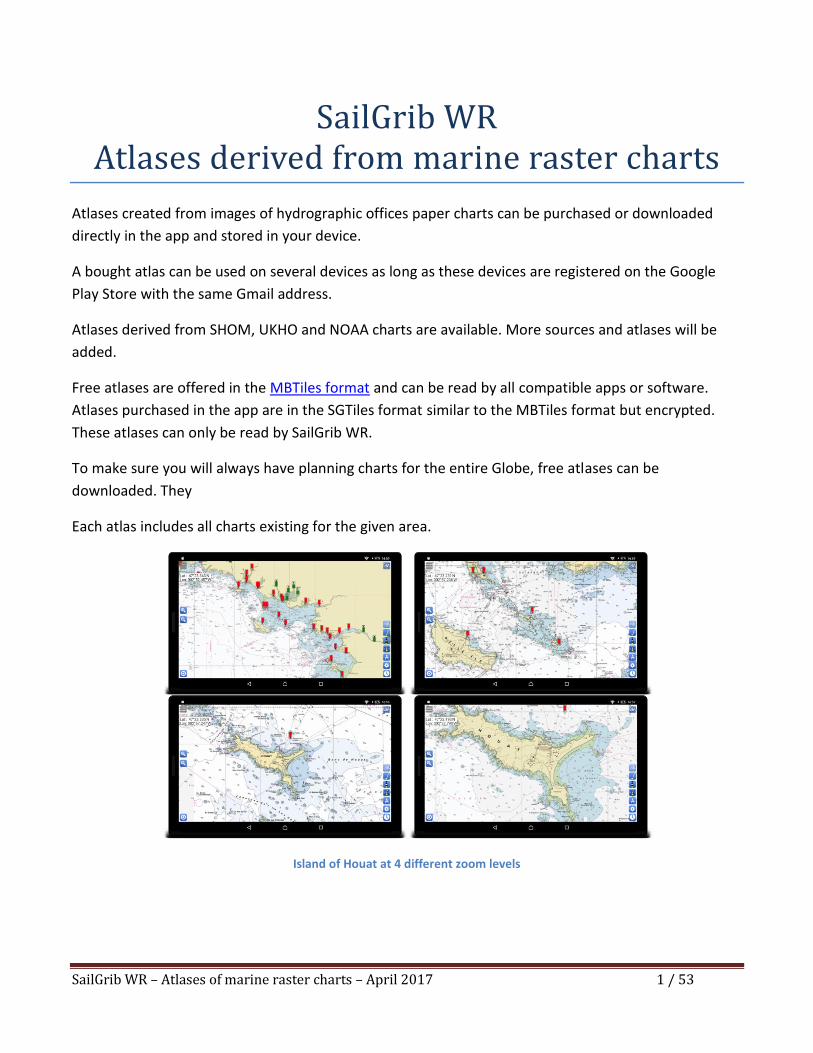
Each atlas includes all charts existing for the given area.
Island of Houat at 4 different zoom levels
SailGrib WR – Atlases of marine raster charts – April 2017 2 / 53
Please note that no official hydrographic office has verified the information contained in the atlases.
They cannot be held responsible for the fidelity of their representation or any subsequent
modification. The possession of these atlases does not exempt from the obligation to use the
appropriate nautical documents provided for by national or international regulations.
Similarly, SailGrib declines all responsibility for the use of these atlases. Again, possession of these
atlases does not relieve the obligation to use the appropriate nautical documents provided for by
national or international regulations.
SailGrib WR – Atlases of marine raster charts – April 2017 3 / 53
Table of contents 1. Purchase an atlas derived from raster marine charts ........................................................................................4
2. SHOM ..................................................................................................................................................................9
2.1. Atlantic........................................................................................................................................................9
2.1.1. From Ile Vierge to San Sebastian ........................................................................................................9
2.1.2. From Ile Vierge to the Pointe de Penmarc’h ................................................................................... 10
2.1.3. From the Chaussée de Sein to Belle-Ile ........................................................................................... 12
2.1.4. From the Peninsula of Quiberon to the Sables-d'Olonne ............................................................... 14
2.1.5. From île d'Yeu to the Pointe de la Coubre ...................................................................................... 16
2.1.6. From île d’Oléron to San Sebastian ................................................................................................. 18
2.2. Mediterranean......................................................................................................................................... 20
2.2.1. From the Cap Cerbère to Menton and Corsica................................................................................ 20
2.2.2. From Cap Cerbère to Marseille ....................................................................................................... 21
2.2.3. From Fos sur Mer to Menton .......................................................................................................... 23
2.2.4. Corsica ............................................................................................................................................. 25
2.3. The Channel ............................................................................................................................................. 27
2.3.1. From Brest to Dunkerque ................................................................................................................ 27
2.3.2. From Brest to Morlaix ...................................................................................................................... 28
2.3.3. From Argenton to Erquy .................................................................................................................. 30
2.3.4. From Paimpol to Cherbourg ............................................................................................................ 32
2.3.5. From the Cap de la Hague to Fécamp ............................................................................................. 34
2.3.6. From Antifer to Dunkerque ............................................................................................................. 36
3. UKHO ............................................................................................................................................................... 38
3.1. Great Britain and Ireland ......................................................................................................................... 38
3.2. The Channel and the south coast of Ireland ........................................................................................... 39
3.3. Spain and Portugal ................................................................................................................................... 40
3.4. East Atlantic Islands: Azores, Madeira, the Canaries and Cabo Verde .................................................... 44
4. The Caribbean islands ...................................................................................................................................... 47
5. NOAA ............................................................................................................................................................... 51
6. Oceans passages and crossings ....................................................................................................................... 53
7. Other sources .................................................................................................................................................. 53
SailGrib WR – Atlases of marine raster charts – April 2017 4 / 53
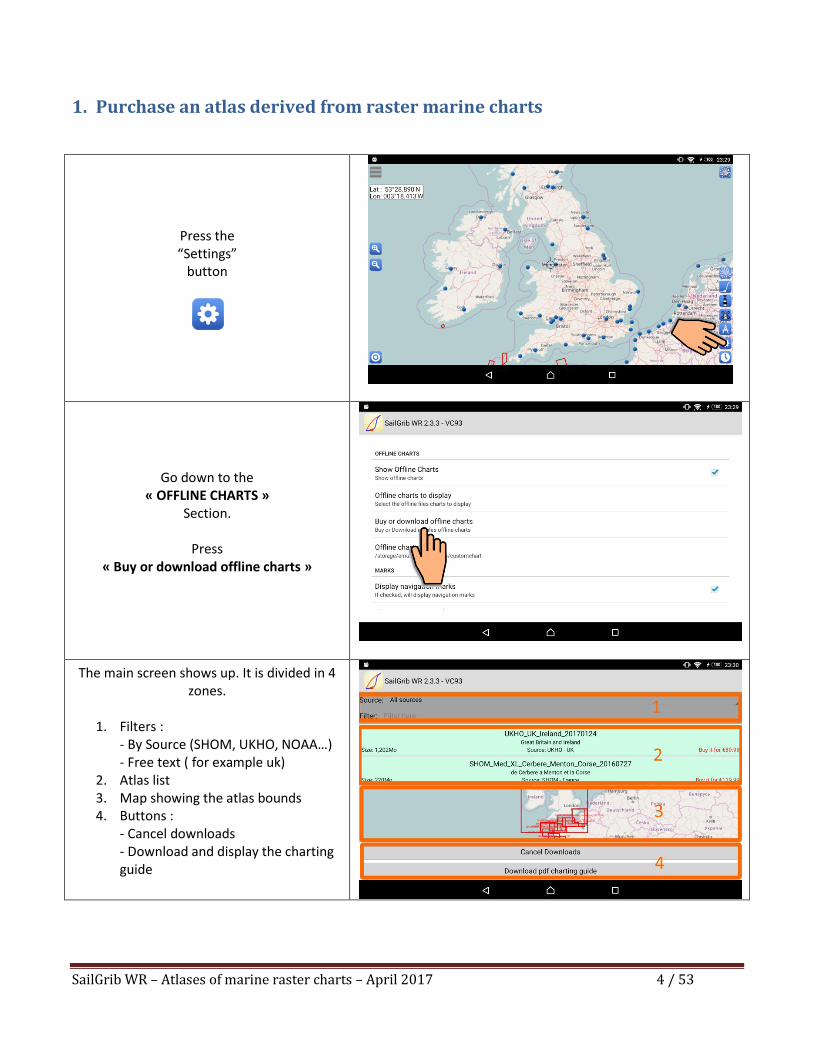
1. Purchase an atlas derived from raster marine charts
Press the “Settings”
button
Go down to the « OFFLINE CHARTS »
Section.
Press « Buy or download offline charts »
The main screen shows up. It is divided in 4 zones.
1. Filters :
- By Source (SHOM, UKHO, NOAA…) - Free text ( for example uk)
2. Atlas list 3. Map showing the atlas bounds 4. Buttons :
- Cancel downloads - Download and display the charting guide
SailGrib WR – Atlases of marine raster charts – April 2017 5 / 53
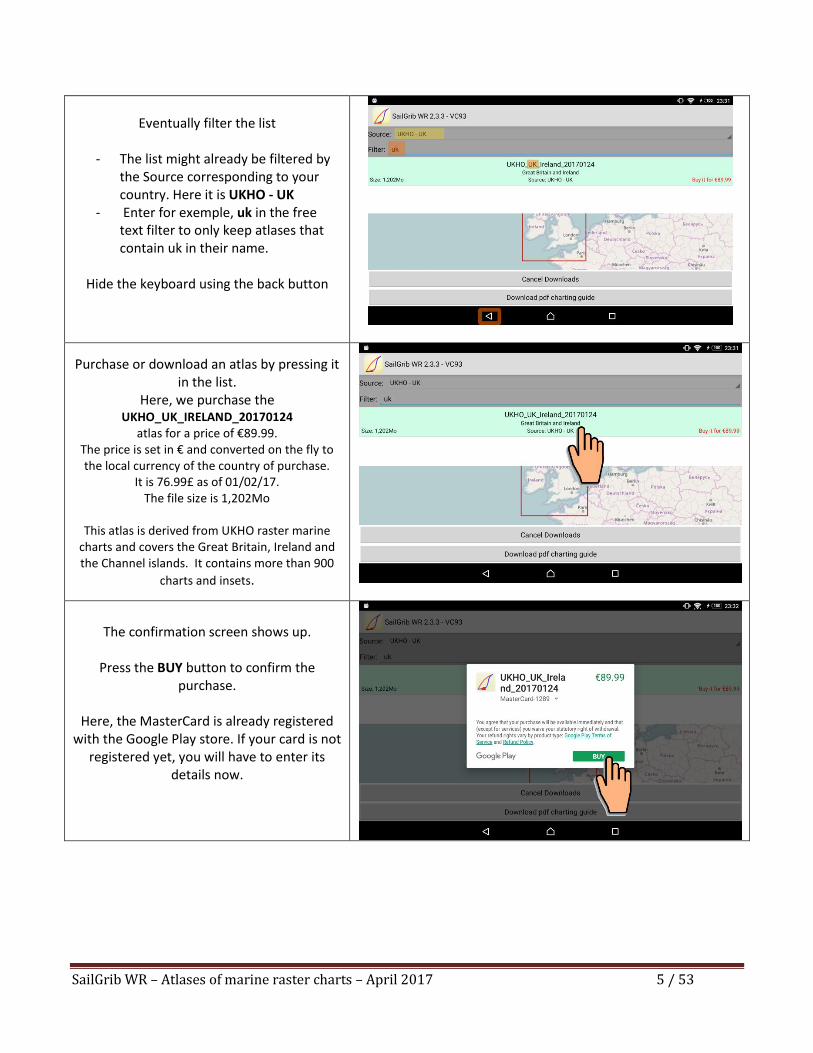
Eventually filter the list
- The list might already be filtered by
the Source corresponding to your country. Here it is UKHO - UK
- Enter for exemple, uk in the free text filter to only keep atlases that contain uk in their name.
Hide the keyboard using the back button
Purchase or download an atlas by pressing it in the list.
Here, we purchase the UKHO_UK_IRELAND_20170124
atlas for a price of €89.99. The price is set in € and converted on the fly to the local currency of the country of purchase.
It is 76.99£ as of 01/02/17. The file size is 1,202Mo
This atlas is derived from UKHO raster marine
charts and covers the Great Britain, Ireland and the Channel islands. It contains more than 900
charts and insets.
The confirmation screen shows up.
Press the BUY button to confirm the purchase.
Here, the MasterCard is already registered
with the Google Play store. If your card is not registered yet, you will have to enter its
details now.
SailGrib WR – Atlases of marine raster charts – April 2017 6 / 53
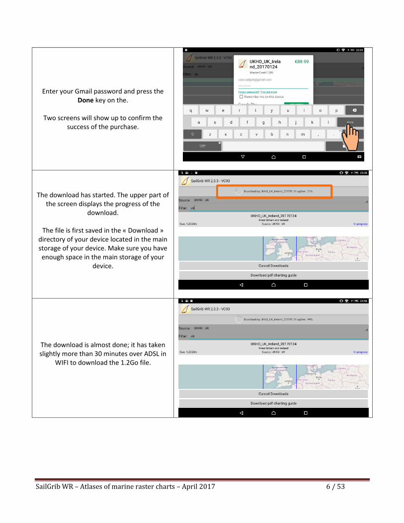
Enter your Gmail password and press the
Done key on the.
Two screens will show up to confirm the success of the purchase.
The download has started. The upper part of the screen displays the progress of the
download.
The file is first saved in the « Download » directory of your device located in the main storage of your device. Make sure you have enough space in the main storage of your
device.
The download is almost done; it has taken slightly more than 30 minutes over ADSL in
WIFI to download the 1.2Go file.
SailGrib WR – Atlases of marine raster charts – April 2017 7 / 53
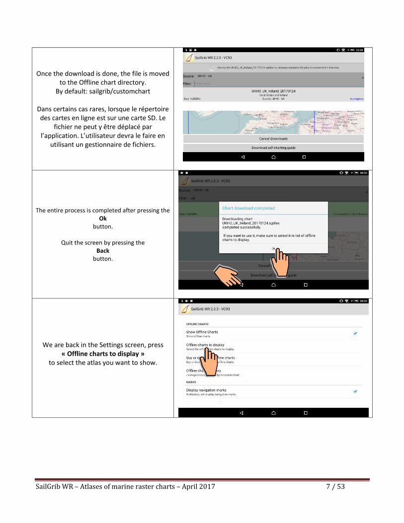
Once the download is done, the file is moved
to the Offline chart directory. By default: sailgrib/customchart
Dans certains cas rares, lorsque le répertoire des cartes en ligne est sur une carte SD. Le
fichier ne peut y être déplacé par l’application. L’utilisateur devra le faire en
utilisant un gestionnaire de fichiers.
The entire process is completed after pressing the Ok
button.
Quit the screen by pressing the Back
button.
We are back in the Settings screen, press « Offline charts to display »
to select the atlas you want to show.
SailGrib WR – Atlases of marine raster charts – April 2017 8 / 53
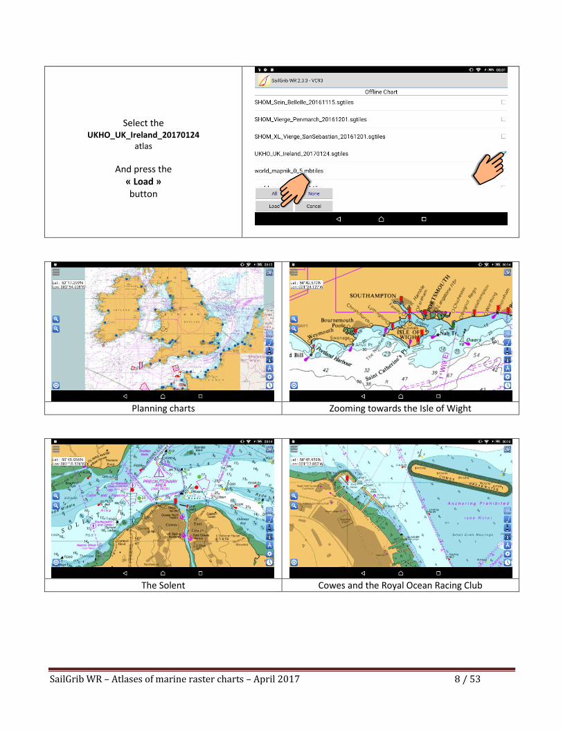
Select the
UKHO_UK_Ireland_20170124 atlas
And press the « Load » button
Planning charts Zooming towards the Isle of Wight
The Solent Cowes and the Royal Ocean Racing Club
SailGrib WR – Atlases of marine raster charts – April 2017 9 / 53
2. SHOM Atlases are derived from SHOM marine raster charts and updated once a year.
The name of the atlas indicates its creation date. Thus the SHOM_SEIN_BELLEILE_20161115 atlas
published November 15, 2016 will be updated once in 2017.
The user can update an atlas in the year following its purchase.
The coast of France is split in 3 regions: Atlantic, The Channel and the Mediterranean. Each region is,
itself, cut into 3 to 5 smaller ones.
2.1. Atlantic
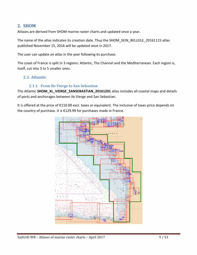
2.1.1. From Ile Vierge to San Sebastian
The Atlantic SHOM_XL_VIERGE_SANSEBASTIAN_20161201 atlas includes all coastal maps and details
of ports and anchorages between ile Vierge and San Sebastian.
It is offered at the price of €110.00 excl. taxes or equivalent. The inclusive of taxes price depends on
the country of purchase. It is €129.99 for purchases made in France.
SailGrib WR – Atlases of marine raster charts – April 2017 10 / 53
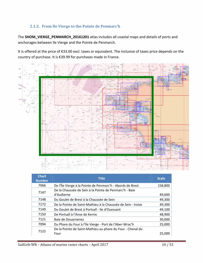
2.1.2. From Ile Vierge to the Pointe de Penmarc’h
The SHOM_VIERGE_PENMARCH_20161201 atlas includes all coastal maps and details of ports and
anchorages between Ile Vierge and the Pointe de Penmarch.
It is offered at the price of €33.00 excl. taxes or equivalent. The inclusive of taxes price depends on the
country of purchase. It is €39.99 for purchases made in France.
Chart Number
Title Scale
7066 De l'Île Vierge à la Pointe de Penmarc'h - Abords de Brest 158,800
7147 De la Chaussée de Sein à la Pointe de Penmarc'h - Baie d'Audierne 49,600
7148 Du Goulet de Brest à la Chaussée de Sein 49,300
7172 De la Pointe de Saint-Mathieu à la Chaussée de Sein - Iroise 49,300
7149 Du Goulet de Brest à Portsall - Ile d'Ouessant 49,100
7150 De Portsall à l'Anse de Kernic 48,900
7121 Baie de Douarnenez 30,000
7094 Du Phare du Four à l'île Vierge - Port de l'Aber-Wrac'h 25,000
7122 De la Pointe de Saint-Mathieu au phare du Four - Chenal du Four 25,000
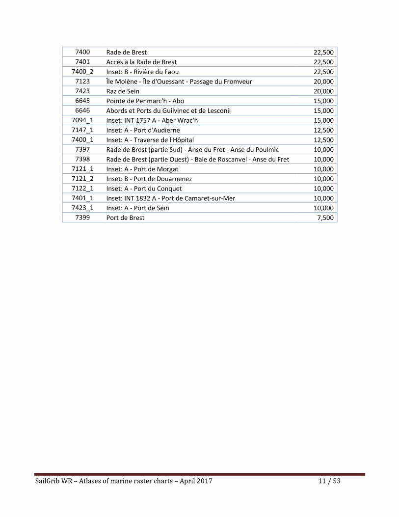
SailGrib WR – Atlases of marine raster charts – April 2017 11 / 53
7400 Rade de Brest 22,500
7401 Accès à la Rade de Brest 22,500
7400_2 Inset: B - Rivière du Faou 22,500
7123 Île Molène - Île d'Ouessant - Passage du Fromveur 20,000
7423 Raz de Sein 20,000
6645 Pointe de Penmarc'h - Abo 15,000
6646 Abords et Ports du Guilvinec et de Lesconil 15,000
7094_1 Inset: INT 1757 A - Aber Wrac'h 15,000
7147_1 Inset: A - Port d'Audierne 12,500
7400_1 Inset: A - Traverse de l'Hôpital 12,500
7397 Rade de Brest (partie Sud) - Anse du Fret - Anse du Poulmic 10,000
7398 Rade de Brest (partie Ouest) - Baie de Roscanvel - Anse du Fret 10,000
7121_1 Inset: A - Port de Morgat 10,000
7121_2 Inset: B - Port de Douarnenez 10,000
7122_1 Inset: A - Port du Conquet 10,000
7401_1 Inset: INT 1832 A - Port de Camaret-sur-Mer 10,000
7423_1 Inset: A - Port de Sein 10,000
7399 Port de Brest 7,500
SailGrib WR – Atlases of marine raster charts – April 2017 12 / 53
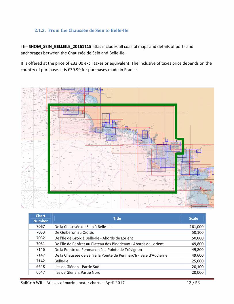
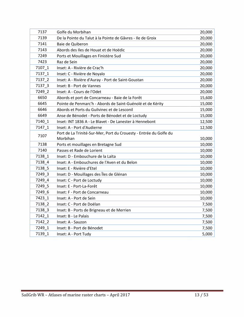
2.1.3. From the Chaussée de Sein to Belle-Ile
The SHOM_SEIN_BELLEILE_20161115 atlas includes all coastal maps and details of ports and
anchorages between the Chaussée de Sein and Belle-Ile.
It is offered at the price of €33.00 excl. taxes or equivalent. The inclusive of taxes price depends on the
country of purchase. It is €39.99 for purchases made in France.
Chart Number
Title Scale
7067 De la Chaussée de Sein à Belle-Ile 161,000
7033 De Quiberon au Croisic 50,100
7032 De l'Île de Groix à Belle-Ile - Abords de Lorient 50,000
7031 De l'île de Penfret au Plateau des Birvideaux - Abords de Lorient 49,800
7146 De la Pointe de Penmarc'h à la Pointe de Trévignon 49,800
7147 De la Chaussée de Sein à la Pointe de Penmarc'h - Baie d'Audierne 49,600
7142 Belle-Ile 25,000
6648 Iles de Glénan - Partie Sud 20,100
6647 Iles de Glénan, Partie Nord 20,000
SailGrib WR – Atlases of marine raster charts – April 2017 13 / 53
7137 Golfe du Morbihan 20,000
7139 De la Pointe du Talut à la Pointe de Gâvres - Ile de Groix 20,000
7141 Baie de Quiberon 20,000
7143 Abords des Iles de Houat et de Hoëdic 20,000
7249 Ports et Mouillages en Finistère Sud 20,000
7423 Raz de Sein 20,000
7107_1 Inset: A - Rivière de Crac'h 20,000
7137_1 Inset: C - Rivière de Noyalo 20,000
7137_2 Inset: A - Rivière d'Auray - Port de Saint-Goustan 20,000
7137_3 Inset: B - Port de Vannes 20,000
7249_2 Inset: A - Cours de l'Odet 20,000
6650 Abords et port de Concarneau - Baie de la Forêt 15,600
6645 Pointe de Penmarc'h - Abords de Saint-Guénolé et de Kérity 15,000
6646 Abords et Ports du Guilvinec et de Lesconil 15,000
6649 Anse de Bénodet - Ports de Bénodet et de Loctudy 15,000
7140_1 Inset: INT 1836 A - Le Blavet - De Lanester à Hennebont 12,500
7147_1 Inset: A - Port d'Audierne 12,500
7107 Port de La Trinité-Sur-Mer, Port du Crouesty - Entrée du Golfe du Morbihan 10,000
7138 Ports et mouillages en Bretagne Sud 10,000
7140 Passes et Rade de Lorient 10,000
7138_1 Inset: D - Embouchure de la Laïta 10,000
7138_4 Inset: A - Embouchures de l'Aven et du Belon 10,000
7138_5 Inset: E - Rivière d'Etel 10,000
7249_3 Inset: D - Mouillages des Îles de Glénan 10,000
7249_4 Inset: C - Port de Loctudy 10,000
7249_5 Inset: E - Port-La-Forêt 10,000
7249_6 Inset: F - Port de Concarneau 10,000
7423_1 Inset: A - Port de Sein 10,000
7138_2 Inset: C - Port de Doëlan 7,500
7138_3 Inset: B - Ports de Brigneau et de Merrien 7,500
7142_1 Inset: B - Le Palais 7,500
7142_2 Inset: A - Sauzon 7,500
7249_1 Inset: B - Port de Bénodet 7,500
7139_1 Inset: A - Port Tudy 5,000
SailGrib WR – Atlases of marine raster charts – April 2017 14 / 53
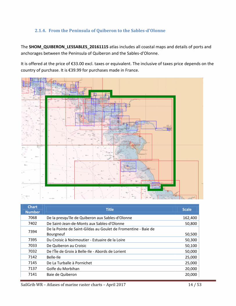
2.1.4. From the Peninsula of Quiberon to the Sables-d'Olonne
The SHOM_QUIBERON_LESSABLES_20161115 atlas includes all coastal maps and details of ports and
anchorages between the Peninsula of Quiberon and the Sables-d'Olonne.
It is offered at the price of €33.00 excl. taxes or equivalent. The inclusive of taxes price depends on the
country of purchase. It is €39.99 for purchases made in France.
Chart Number
Title Scale
7068 De la presqu'île de Quiberon aux Sables-d'Olonne 162,400
7402 De Saint-Jean-de-Monts aux Sables-d'Olonne 50,800
7394 De la Pointe de Saint-Gildas au Goulet de Fromentine - Baie de Bourgneuf 50,500
7395 Du Croisic à Noirmoutier - Estuaire de la Loire 50,300
7033 De Quiberon au Croisic 50,100
7032 De l'Île de Groix à Belle-Ile - Abords de Lorient 50,000
7142 Belle-Ile 25,000
7145 De La Turballe à Pornichet 25,000
7137 Golfe du Morbihan 20,000
7141 Baie de Quiberon 20,000
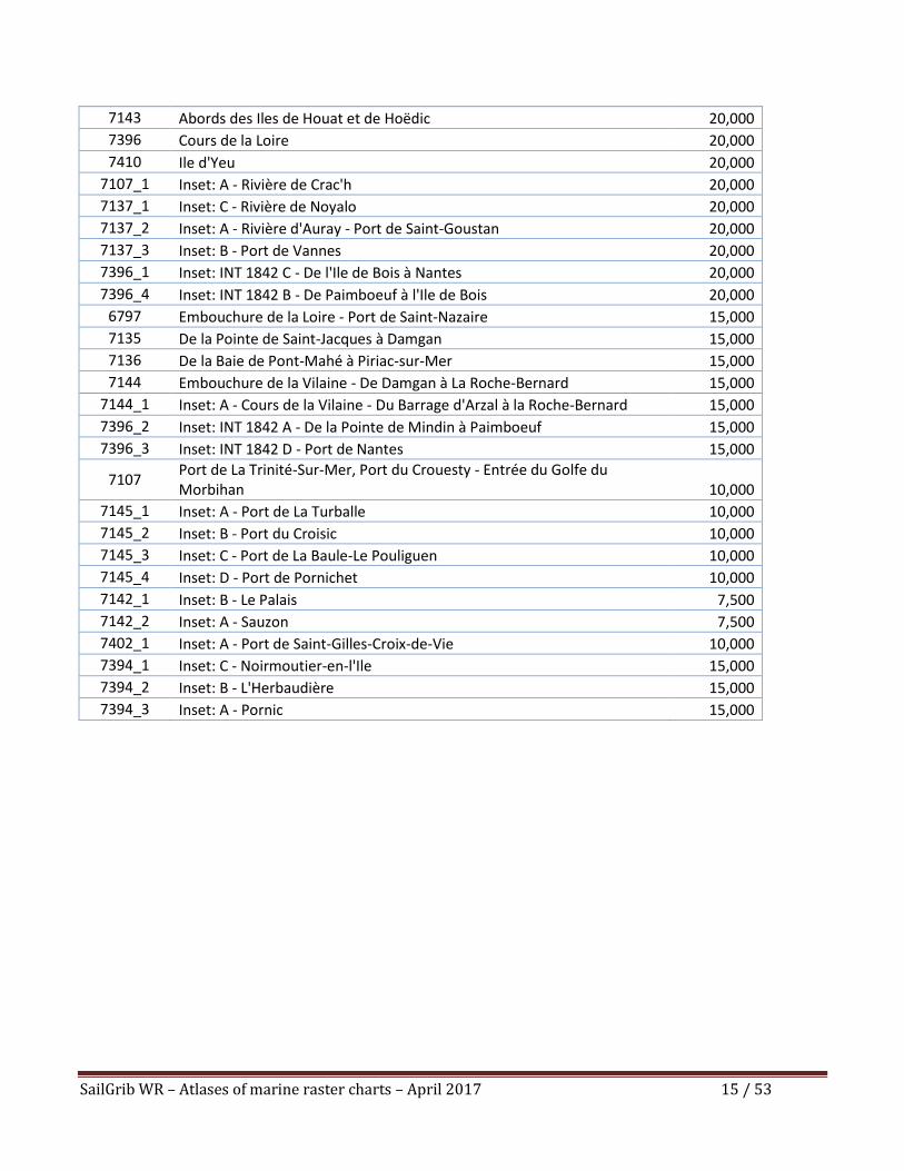
SailGrib WR – Atlases of marine raster charts – April 2017 15 / 53
7143 Abords des Iles de Houat et de Hoëdic 20,000
7396 Cours de la Loire 20,000
7410 Ile d'Yeu 20,000
7107_1 Inset: A - Rivière de Crac'h 20,000
7137_1 Inset: C - Rivière de Noyalo 20,000
7137_2 Inset: A - Rivière d'Auray - Port de Saint-Goustan 20,000
7137_3 Inset: B - Port de Vannes 20,000
7396_1 Inset: INT 1842 C - De l'Ile de Bois à Nantes 20,000
7396_4 Inset: INT 1842 B - De Paimboeuf à l'Ile de Bois 20,000
6797 Embouchure de la Loire - Port de Saint-Nazaire 15,000
7135 De la Pointe de Saint-Jacques à Damgan 15,000
7136 De la Baie de Pont-Mahé à Piriac-sur-Mer 15,000
7144 Embouchure de la Vilaine - De Damgan à La Roche-Bernard 15,000
7144_1 Inset: A - Cours de la Vilaine - Du Barrage d'Arzal à la Roche-Bernard 15,000
7396_2 Inset: INT 1842 A - De la Pointe de Mindin à Paimboeuf 15,000
7396_3 Inset: INT 1842 D - Port de Nantes 15,000
7107 Port de La Trinité-Sur-Mer, Port du Crouesty - Entrée du Golfe du Morbihan 10,000
7145_1 Inset: A - Port de La Turballe 10,000
7145_2 Inset: B - Port du Croisic 10,000
7145_3 Inset: C - Port de La Baule-Le Pouliguen 10,000
7145_4 Inset: D - Port de Pornichet 10,000
7142_1 Inset: B - Le Palais 7,500
7142_2 Inset: A - Sauzon 7,500
7402_1 Inset: A - Port de Saint-Gilles-Croix-de-Vie 10,000
7394_1 Inset: C - Noirmoutier-en-l'Ile 15,000
7394_2 Inset: B - L'Herbaudière 15,000
7394_3 Inset: A - Pornic 15,000
SailGrib WR – Atlases of marine raster charts – April 2017 16 / 53
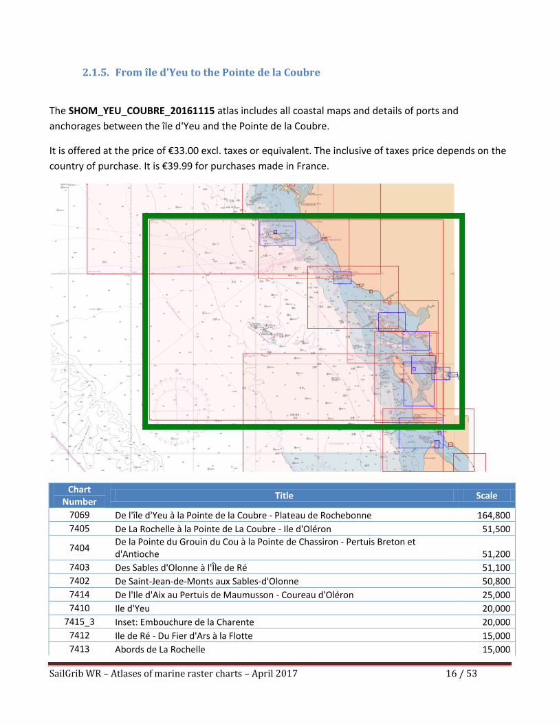
2.1.5. From île d'Yeu to the Pointe de la Coubre
The SHOM_YEU_COUBRE_20161115 atlas includes all coastal maps and details of ports and
anchorages between the île d'Yeu and the Pointe de la Coubre.
It is offered at the price of €33.00 excl. taxes or equivalent. The inclusive of taxes price depends on the
country of purchase. It is €39.99 for purchases made in France.
Chart Number
Title Scale
7069 De l'île d'Yeu à la Pointe de la Coubre - Plateau de Rochebonne 164,800
7405 De La Rochelle à la Pointe de La Coubre - Ile d'Oléron 51,500
7404 De la Pointe du Grouin du Cou à la Pointe de Chassiron - Pertuis Breton et d'Antioche 51,200
7403 Des Sables d'Olonne à l'Île de Ré 51,100
7402 De Saint-Jean-de-Monts aux Sables-d'Olonne 50,800
7414 De l'Ile d'Aix au Pertuis de Maumusson - Coureau d'Oléron 25,000
7410 Ile d'Yeu 20,000
7415_3 Inset: Embouchure de la Charente 20,000
7412 Ile de Ré - Du Fier d'Ars à la Flotte 15,000
7413 Abords de La Rochelle 15,000
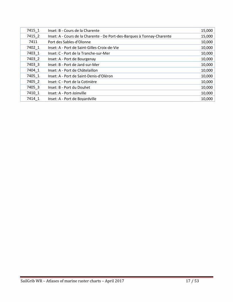
SailGrib WR – Atlases of marine raster charts – April 2017 17 / 53
7415_1 Inset: B - Cours de la Charente 15,000
7415_2 Inset: A - Cours de la Charente - De Port-des-Barques à Tonnay-Charente 15,000
7411 Port des Sables-d'Olonne 10,000
7402_1 Inset: A - Port de Saint-Gilles-Croix-de-Vie 10,000
7403_1 Inset: C - Port de la Tranche-sur-Mer 10,000
7403_2 Inset: A - Port de Bourgenay 10,000
7403_3 Inset: B - Port de Jard-sur-Mer 10,000
7404_1 Inset: A - Port de Châtelaillon 10,000
7405_1 Inset: A - Port de Saint-Denis-d'Oléron 10,000
7405_2 Inset: C - Port de la Cotinière 10,000
7405_3 Inset: B - Port du Douhet 10,000
7410_1 Inset: A - Port-Joinville 10,000
7414_1 Inset: A - Port de Boyardville 10,000
SailGrib WR – Atlases of marine raster charts – April 2017 18 / 53
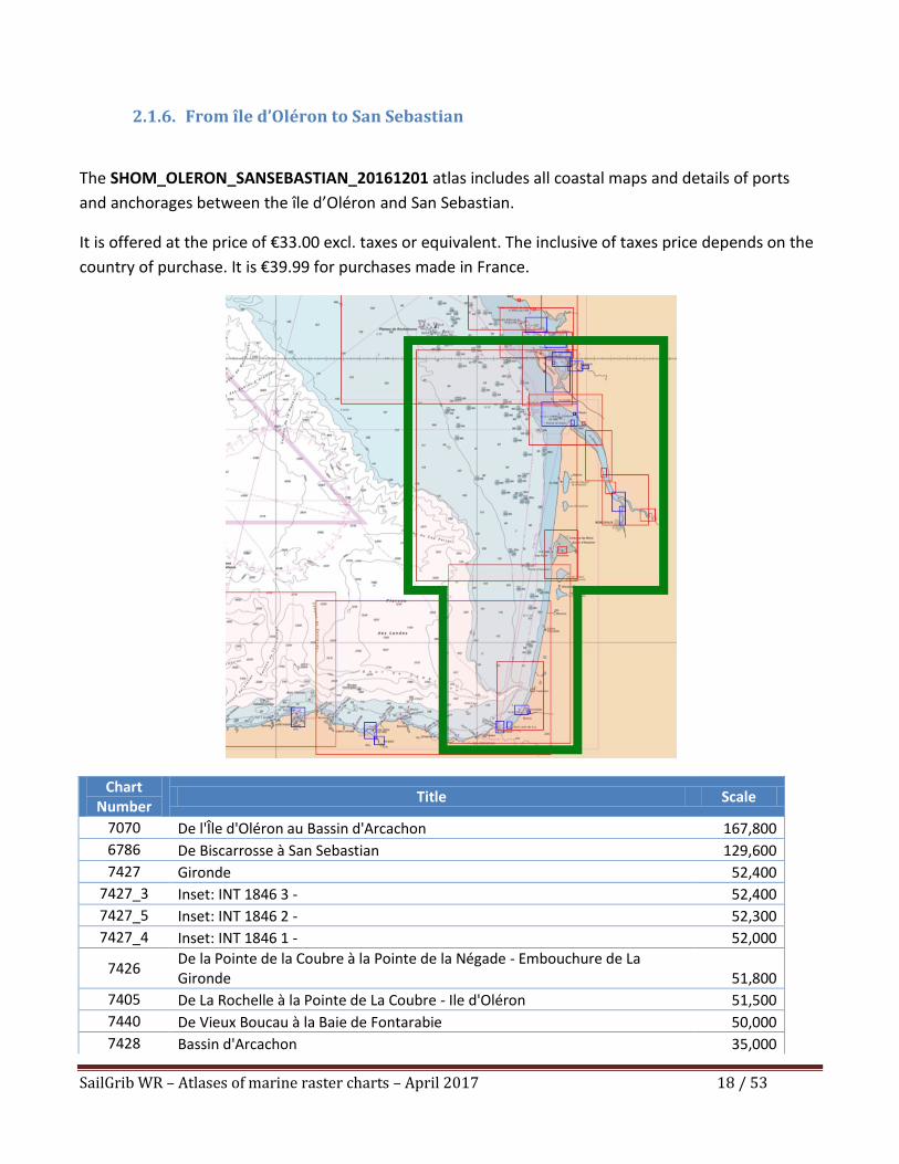
2.1.6. From île d’Oléron to San Sebastian
The SHOM_OLERON_SANSEBASTIAN_20161201 atlas includes all coastal maps and details of ports
and anchorages between the île d’Oléron and San Sebastian.
It is offered at the price of €33.00 excl. taxes or equivalent. The inclusive of taxes price depends on the
country of purchase. It is €39.99 for purchases made in France.
Chart Number
Title Scale
7070 De l'Île d'Oléron au Bassin d'Arcachon 167,800
6786 De Biscarrosse à San Sebastian 129,600
7427 Gironde 52,400
7427_3 Inset: INT 1846 3 - 52,400
7427_5 Inset: INT 1846 2 - 52,300
7427_4 Inset: INT 1846 1 - 52,000
7426 De la Pointe de la Coubre à la Pointe de la Négade - Embouchure de La Gironde 51,800
7405 De La Rochelle à la Pointe de La Coubre - Ile d'Oléron 51,500
7440 De Vieux Boucau à la Baie de Fontarabie 50,000
7428 Bassin d'Arcachon 35,000
SailGrib WR – Atlases of marine raster charts – April 2017 19 / 53
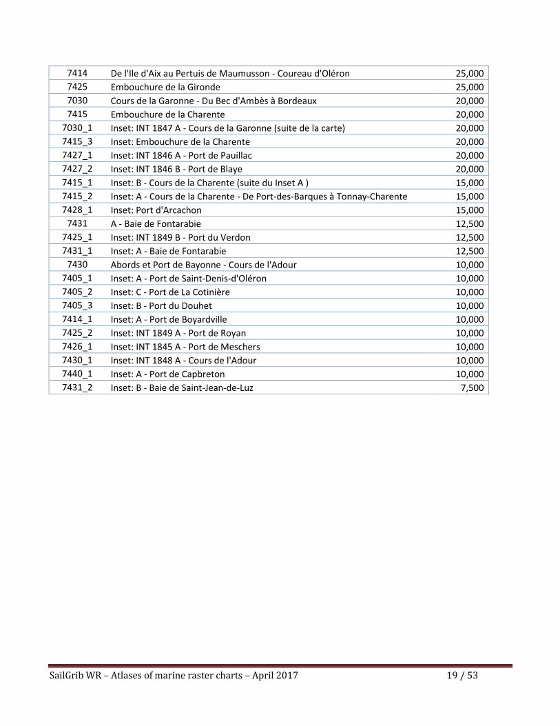
7414 De l'Ile d'Aix au Pertuis de Maumusson - Coureau d'Oléron 25,000
7425 Embouchure de la Gironde 25,000
7030 Cours de la Garonne - Du Bec d'Ambès à Bordeaux 20,000
7415 Embouchure de la Charente 20,000
7030_1 Inset: INT 1847 A - Cours de la Garonne (suite de la carte) 20,000
7415_3 Inset: Embouchure de la Charente 20,000
7427_1 Inset: INT 1846 A - Port de Pauillac 20,000
7427_2 Inset: INT 1846 B - Port de Blaye 20,000
7415_1 Inset: B - Cours de la Charente (suite du Inset A ) 15,000
7415_2 Inset: A - Cours de la Charente - De Port-des-Barques à Tonnay-Charente 15,000
7428_1 Inset: Port d'Arcachon 15,000
7431 A - Baie de Fontarabie 12,500
7425_1 Inset: INT 1849 B - Port du Verdon 12,500
7431_1 Inset: A - Baie de Fontarabie 12,500
7430 Abords et Port de Bayonne - Cours de l'Adour 10,000
7405_1 Inset: A - Port de Saint-Denis-d'Oléron 10,000
7405_2 Inset: C - Port de La Cotinière 10,000
7405_3 Inset: B - Port du Douhet 10,000
7414_1 Inset: A - Port de Boyardville 10,000
7425_2 Inset: INT 1849 A - Port de Royan 10,000
7426_1 Inset: INT 1845 A - Port de Meschers 10,000
7430_1 Inset: INT 1848 A - Cours de l'Adour 10,000
7440_1 Inset: A - Port de Capbreton 10,000
7431_2 Inset: B - Baie de Saint-Jean-de-Luz 7,500

SailGrib WR – Atlases of marine raster charts – April 2017 20 / 53
2.2. Mediterranean
2.2.1. From the Cap Cerbère to Menton and Corsica
The atlas SHOM_XL_CERBERE_MENTON_CORSE_20170201 includes:
- All coastal maps and details of ports and anchorages between the Cap Cerbère and Menton,
- All coastal maps and details of ports and anchorages of Corsica,
- The 7203, 7204 and 7507 planning charts.
It is offered at the price of €100.00 excl. taxes or equivalent. The inclusive of taxes price depends on
the country of purchase. It is €119.99 for purchases made in France.
SailGrib WR – Atlases of marine raster charts – April 2017 21 / 53
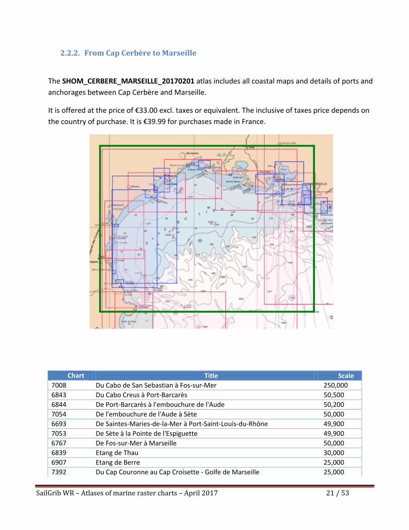
2.2.2. From Cap Cerbère to Marseille
The SHOM_CERBERE_MARSEILLE_20170201 atlas includes all coastal maps and details of ports and
anchorages between Cap Cerbère and Marseille.
It is offered at the price of €33.00 excl. taxes or equivalent. The inclusive of taxes price depends on
the country of purchase. It is €39.99 for purchases made in France.
Chart Number
Title Scale
7008 Du Cabo de San Sebastian à Fos-sur-Mer 250,000
6843 Du Cabo Creus à Port-Barcarès 50,500
6844 De Port-Barcarès à l'embouchure de l'Aude 50,200
7054 De l'embouchure de l'Aude à Sète 50,000
6693 De Saintes-Maries-de-la-Mer à Port-Saint-Louis-du-Rhône 49,900
7053 De Sète à la Pointe de l'Espiguette 49,900
6767 De Fos-sur-Mer à Marseille 50,000
6839 Etang de Thau 30,000
6907 Etang de Berre 25,000
7392 Du Cap Couronne au Cap Croisette - Golfe de Marseille 25,000
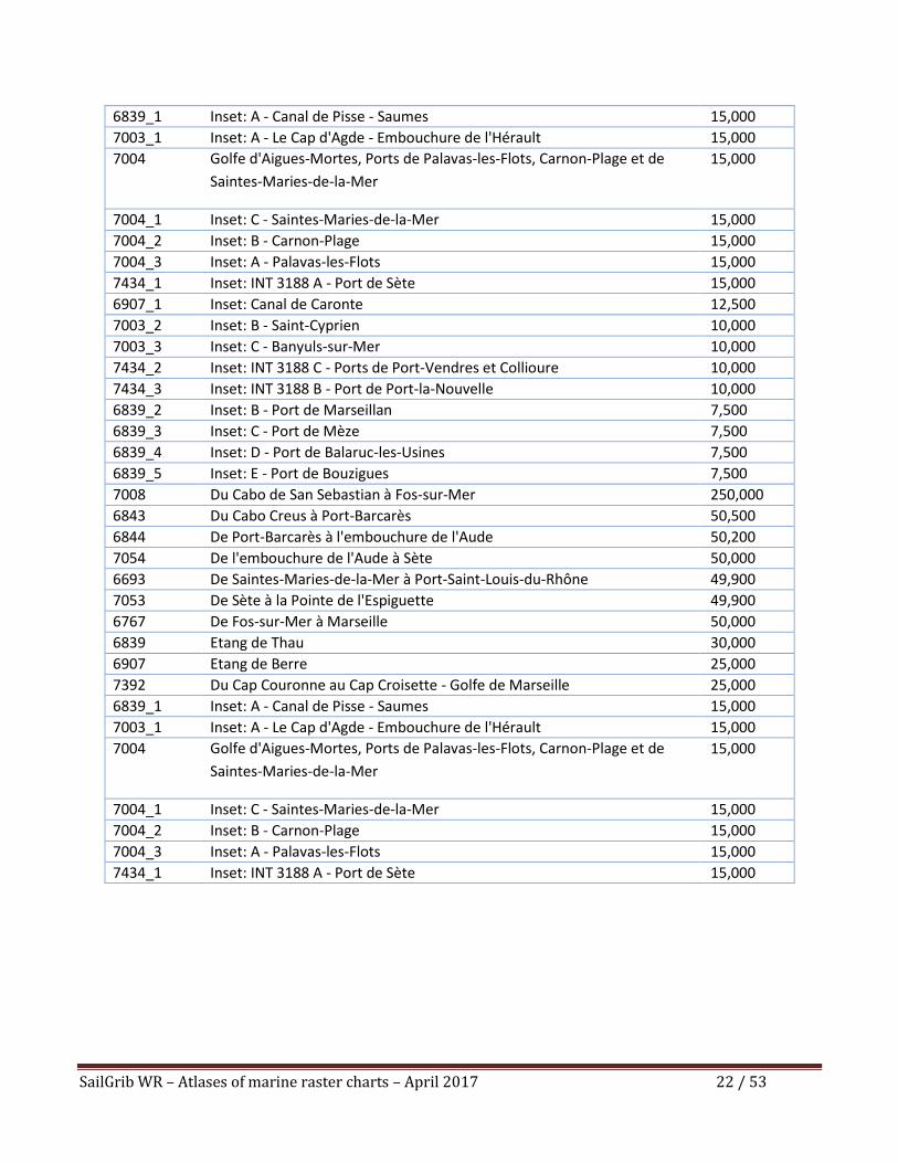
SailGrib WR – Atlases of marine raster charts – April 2017 22 / 53
6839_1 Inset: A - Canal de Pisse - Saumes 15,000
7003_1 Inset: A - Le Cap d'Agde - Embouchure de l'Hérault 15,000
7004 Golfe d'Aigues-Mortes, Ports de Palavas-les-Flots, Carnon-Plage et de
Saintes-Maries-de-la-Mer
15,000
7004_1 Inset: C - Saintes-Maries-de-la-Mer 15,000
7004_2 Inset: B - Carnon-Plage 15,000
7004_3 Inset: A - Palavas-les-Flots 15,000
7434_1 Inset: INT 3188 A - Port de Sète 15,000
6907_1 Inset: Canal de Caronte 12,500
7003_2 Inset: B - Saint-Cyprien 10,000
7003_3 Inset: C - Banyuls-sur-Mer 10,000
7434_2 Inset: INT 3188 C - Ports de Port-Vendres et Collioure 10,000
7434_3 Inset: INT 3188 B - Port de Port-la-Nouvelle 10,000
6839_2 Inset: B - Port de Marseillan 7,500
6839_3 Inset: C - Port de Mèze 7,500
6839_4 Inset: D - Port de Balaruc-les-Usines 7,500
6839_5 Inset: E - Port de Bouzigues 7,500
7008 Du Cabo de San Sebastian à Fos-sur-Mer 250,000
6843 Du Cabo Creus à Port-Barcarès 50,500
6844 De Port-Barcarès à l'embouchure de l'Aude 50,200
7054 De l'embouchure de l'Aude à Sète 50,000
6693 De Saintes-Maries-de-la-Mer à Port-Saint-Louis-du-Rhône 49,900
7053 De Sète à la Pointe de l'Espiguette 49,900
6767 De Fos-sur-Mer à Marseille 50,000
6839 Etang de Thau 30,000
6907 Etang de Berre 25,000
7392 Du Cap Couronne au Cap Croisette - Golfe de Marseille 25,000
6839_1 Inset: A - Canal de Pisse - Saumes 15,000
7003_1 Inset: A - Le Cap d'Agde - Embouchure de l'Hérault 15,000
7004 Golfe d'Aigues-Mortes, Ports de Palavas-les-Flots, Carnon-Plage et de
Saintes-Maries-de-la-Mer
15,000
7004_1 Inset: C - Saintes-Maries-de-la-Mer 15,000
7004_2 Inset: B - Carnon-Plage 15,000
7004_3 Inset: A - Palavas-les-Flots 15,000
7434_1 Inset: INT 3188 A - Port de Sète 15,000
SailGrib WR – Atlases of marine raster charts – April 2017 23 / 53
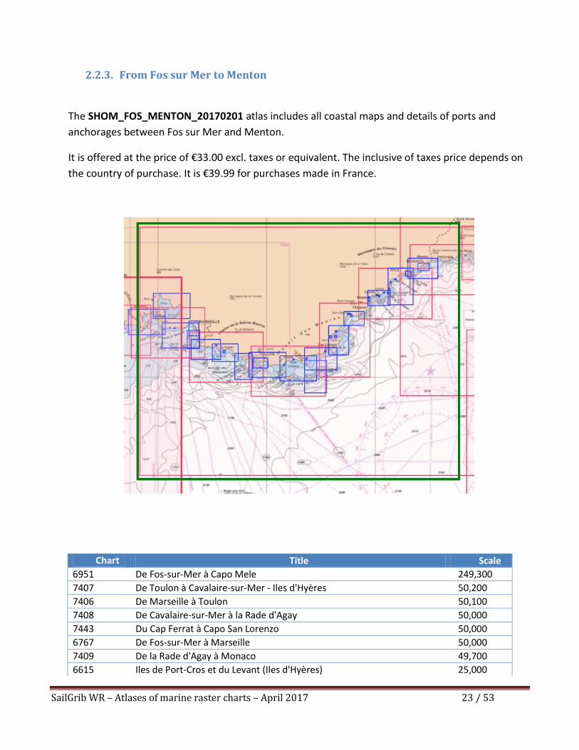
2.2.3. From Fos sur Mer to Menton
The SHOM_FOS_MENTON_20170201 atlas includes all coastal maps and details of ports and
anchorages between Fos sur Mer and Menton.
It is offered at the price of €33.00 excl. taxes or equivalent. The inclusive of taxes price depends on
the country of purchase. It is €39.99 for purchases made in France.
Chart Number
Title Scale
6951 De Fos-sur-Mer à Capo Mele 249,300
7407 De Toulon à Cavalaire-sur-Mer - Iles d'Hyères 50,200
7406 De Marseille à Toulon 50,100
7408 De Cavalaire-sur-Mer à la Rade d'Agay 50,000
7443 Du Cap Ferrat à Capo San Lorenzo 50,000
6767 De Fos-sur-Mer à Marseille 50,000
7409 De la Rade d'Agay à Monaco 49,700
6615 Iles de Port-Cros et du Levant (Iles d'Hyères) 25,000
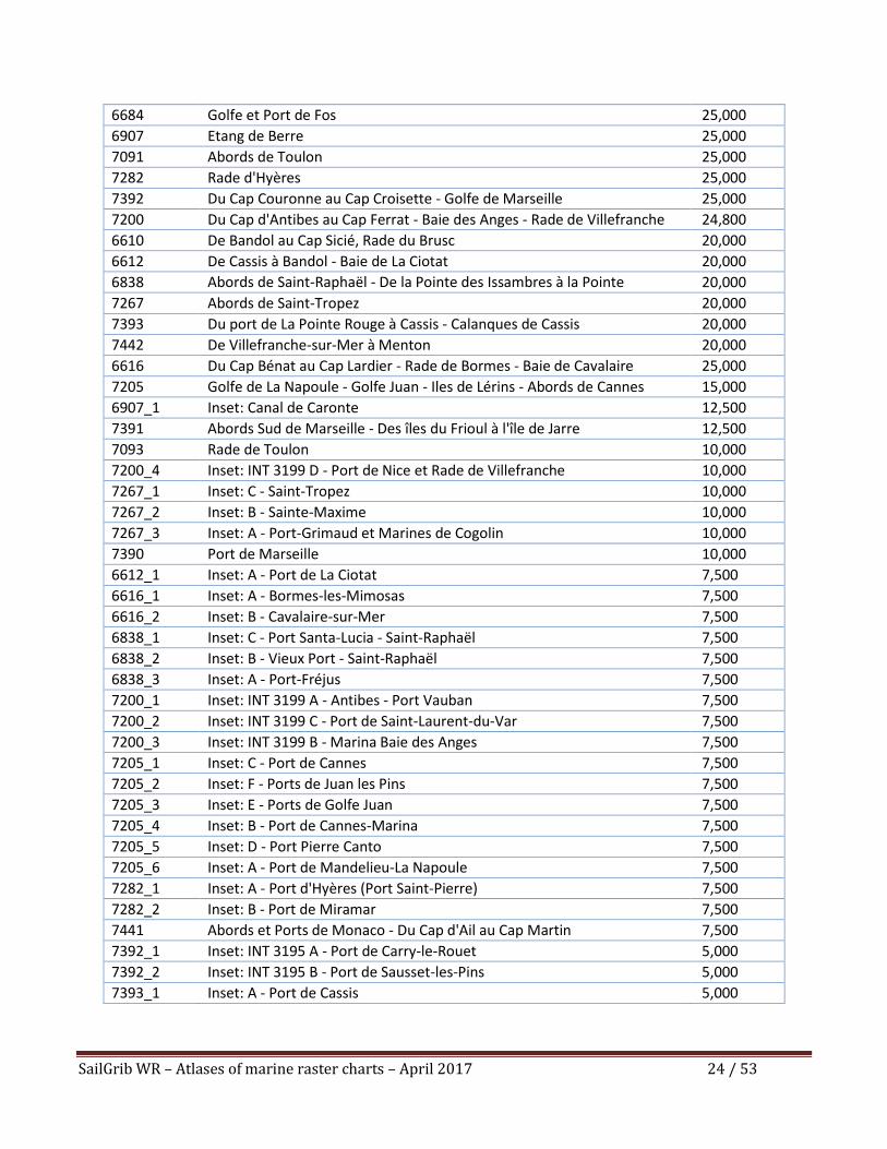
SailGrib WR – Atlases of marine raster charts – April 2017 24 / 53
6684 Golfe et Port de Fos 25,000
6907 Etang de Berre 25,000
7091 Abords de Toulon 25,000
7282 Rade d'Hyères 25,000
7392 Du Cap Couronne au Cap Croisette - Golfe de Marseille 25,000
7200 Du Cap d'Antibes au Cap Ferrat - Baie des Anges - Rade de Villefranche 24,800
6610 De Bandol au Cap Sicié, Rade du Brusc 20,000
6612 De Cassis à Bandol - Baie de La Ciotat 20,000
6838 Abords de Saint-Raphaël - De la Pointe des Issambres à la Pointe
d'Anthéor
20,000
7267 Abords de Saint-Tropez 20,000
7393 Du port de La Pointe Rouge à Cassis - Calanques de Cassis 20,000
7442 De Villefranche-sur-Mer à Menton 20,000
6616 Du Cap Bénat au Cap Lardier - Rade de Bormes - Baie de Cavalaire 25,000
7205 Golfe de La Napoule - Golfe Juan - Iles de Lérins - Abords de Cannes 15,000
6907_1 Inset: Canal de Caronte 12,500
7391 Abords Sud de Marseille - Des îles du Frioul à l'île de Jarre 12,500
7093 Rade de Toulon 10,000
7200_4 Inset: INT 3199 D - Port de Nice et Rade de Villefranche 10,000
7267_1 Inset: C - Saint-Tropez 10,000
7267_2 Inset: B - Sainte-Maxime 10,000
7267_3 Inset: A - Port-Grimaud et Marines de Cogolin 10,000
7390 Port de Marseille 10,000
6612_1 Inset: A - Port de La Ciotat 7,500
6616_1 Inset: A - Bormes-les-Mimosas 7,500
6616_2 Inset: B - Cavalaire-sur-Mer 7,500
6838_1 Inset: C - Port Santa-Lucia - Saint-Raphaël 7,500
6838_2 Inset: B - Vieux Port - Saint-Raphaël 7,500
6838_3 Inset: A - Port-Fréjus 7,500
7200_1 Inset: INT 3199 A - Antibes - Port Vauban 7,500
7200_2 Inset: INT 3199 C - Port de Saint-Laurent-du-Var 7,500
7200_3 Inset: INT 3199 B - Marina Baie des Anges 7,500
7205_1 Inset: C - Port de Cannes 7,500
7205_2 Inset: F - Ports de Juan les Pins 7,500
7205_3 Inset: E - Ports de Golfe Juan 7,500
7205_4 Inset: B - Port de Cannes-Marina 7,500
7205_5 Inset: D - Port Pierre Canto 7,500
7205_6 Inset: A - Port de Mandelieu-La Napoule 7,500
7282_1 Inset: A - Port d'Hyères (Port Saint-Pierre) 7,500
7282_2 Inset: B - Port de Miramar 7,500
7441 Abords et Ports de Monaco - Du Cap d'Ail au Cap Martin 7,500
7392_1 Inset: INT 3195 A - Port de Carry-le-Rouet 5,000
7392_2 Inset: INT 3195 B - Port de Sausset-les-Pins 5,000
7393_1 Inset: A - Port de Cassis 5,000
SailGrib WR – Atlases of marine raster charts – April 2017 25 / 53
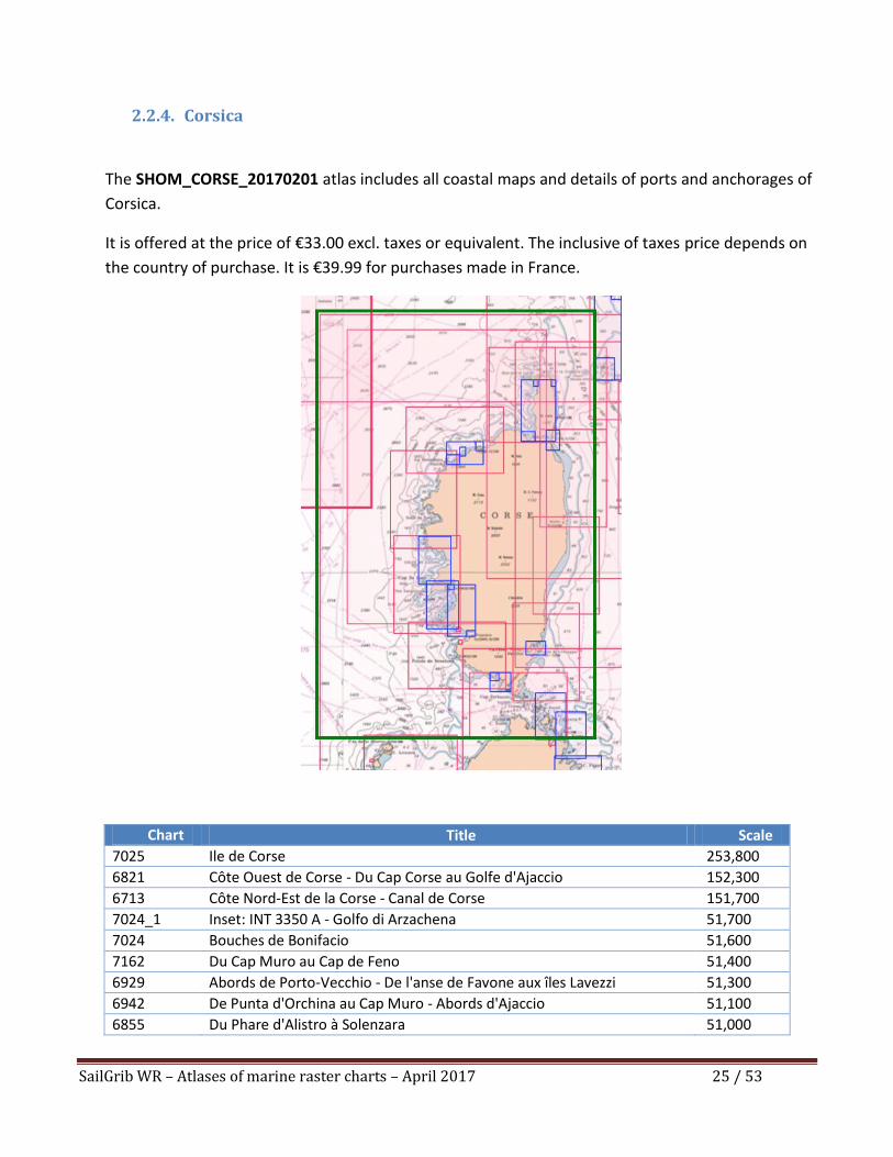
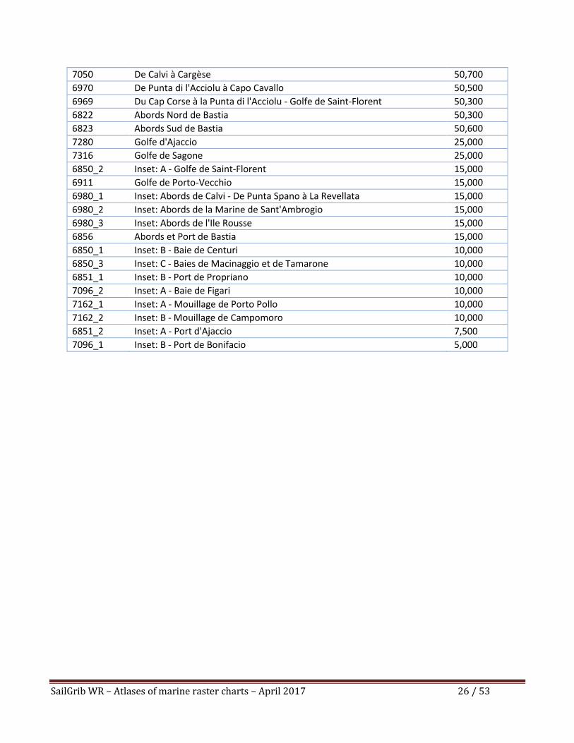
2.2.4. Corsica
The SHOM_CORSE_20170201 atlas includes all coastal maps and details of ports and anchorages of
Corsica.
It is offered at the price of €33.00 excl. taxes or equivalent. The inclusive of taxes price depends on
the country of purchase. It is €39.99 for purchases made in France.
Chart Number
Title Scale
7025 Ile de Corse 253,800
6821 Côte Ouest de Corse - Du Cap Corse au Golfe d'Ajaccio 152,300
6713 Côte Nord-Est de la Corse - Canal de Corse 151,700
7024_1 Inset: INT 3350 A - Golfo di Arzachena 51,700
7024 Bouches de Bonifacio 51,600
7162 Du Cap Muro au Cap de Feno 51,400
6929 Abords de Porto-Vecchio - De l'anse de Favone aux îles Lavezzi 51,300
6942 De Punta d'Orchina au Cap Muro - Abords d'Ajaccio 51,100
6855 Du Phare d'Alistro à Solenzara 51,000
SailGrib WR – Atlases of marine raster charts – April 2017 26 / 53
7050 De Calvi à Cargèse 50,700
6970 De Punta di l'Acciolu à Capo Cavallo 50,500
6969 Du Cap Corse à la Punta di l'Acciolu - Golfe de Saint-Florent 50,300
6822 Abords Nord de Bastia 50,300
6823 Abords Sud de Bastia 50,600
7280 Golfe d'Ajaccio 25,000
7316 Golfe de Sagone 25,000
6850_2 Inset: A - Golfe de Saint-Florent 15,000
6911 Golfe de Porto-Vecchio 15,000
6980_1 Inset: Abords de Calvi - De Punta Spano à La Revellata 15,000
6980_2 Inset: Abords de la Marine de Sant'Ambrogio 15,000
6980_3 Inset: Abords de l'Ile Rousse 15,000
6856 Abords et Port de Bastia 15,000
6850_1 Inset: B - Baie de Centuri 10,000
6850_3 Inset: C - Baies de Macinaggio et de Tamarone 10,000
6851_1 Inset: B - Port de Propriano 10,000
7096_2 Inset: A - Baie de Figari 10,000
7162_1 Inset: A - Mouillage de Porto Pollo 10,000
7162_2 Inset: B - Mouillage de Campomoro 10,000
6851_2 Inset: A - Port d'Ajaccio 7,500
7096_1 Inset: B - Port de Bonifacio 5,000
SailGrib WR – Atlases of marine raster charts – April 2017 27 / 53
2.3. The Channel
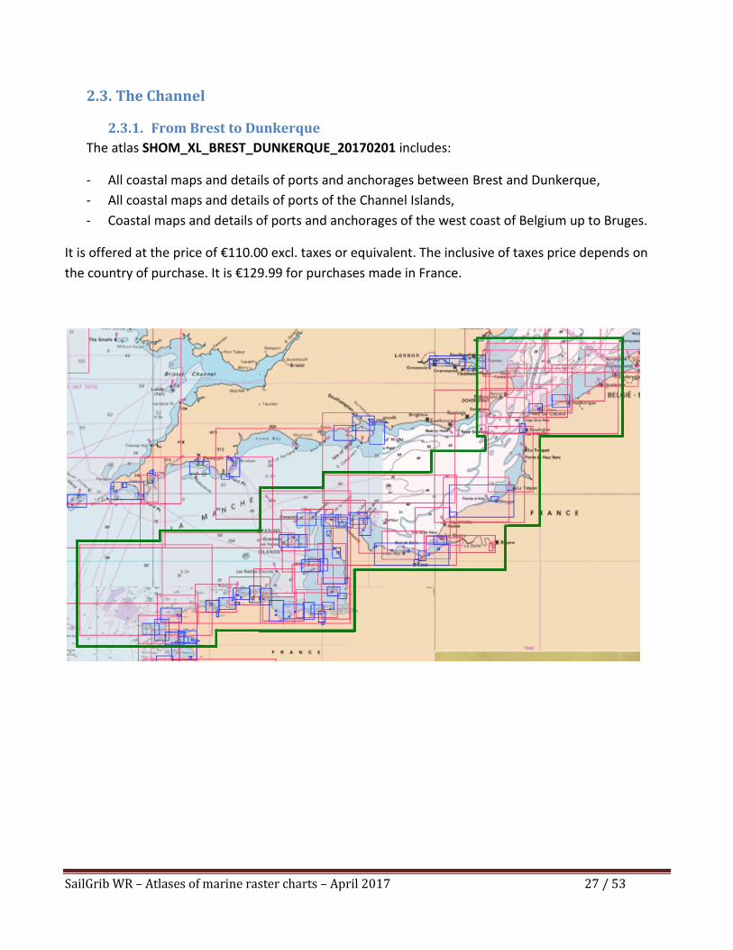
2.3.1. From Brest to Dunkerque
The atlas SHOM_XL_BREST_DUNKERQUE_20170201 includes:
- All coastal maps and details of ports and anchorages between Brest and Dunkerque,
- All coastal maps and details of ports of the Channel Islands,
- Coastal maps and details of ports and anchorages of the west coast of Belgium up to Bruges.
It is offered at the price of €110.00 excl. taxes or equivalent. The inclusive of taxes price depends on
the country of purchase. It is €129.99 for purchases made in France.
SailGrib WR – Atlases of marine raster charts – April 2017 28 / 53
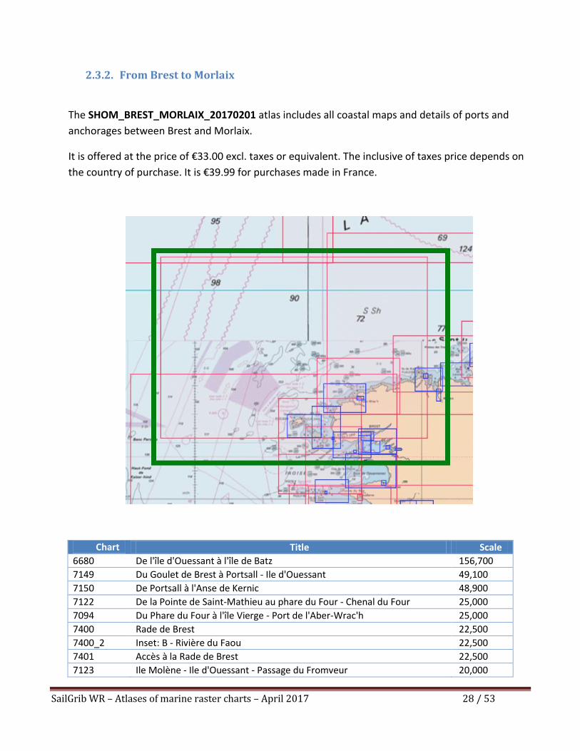
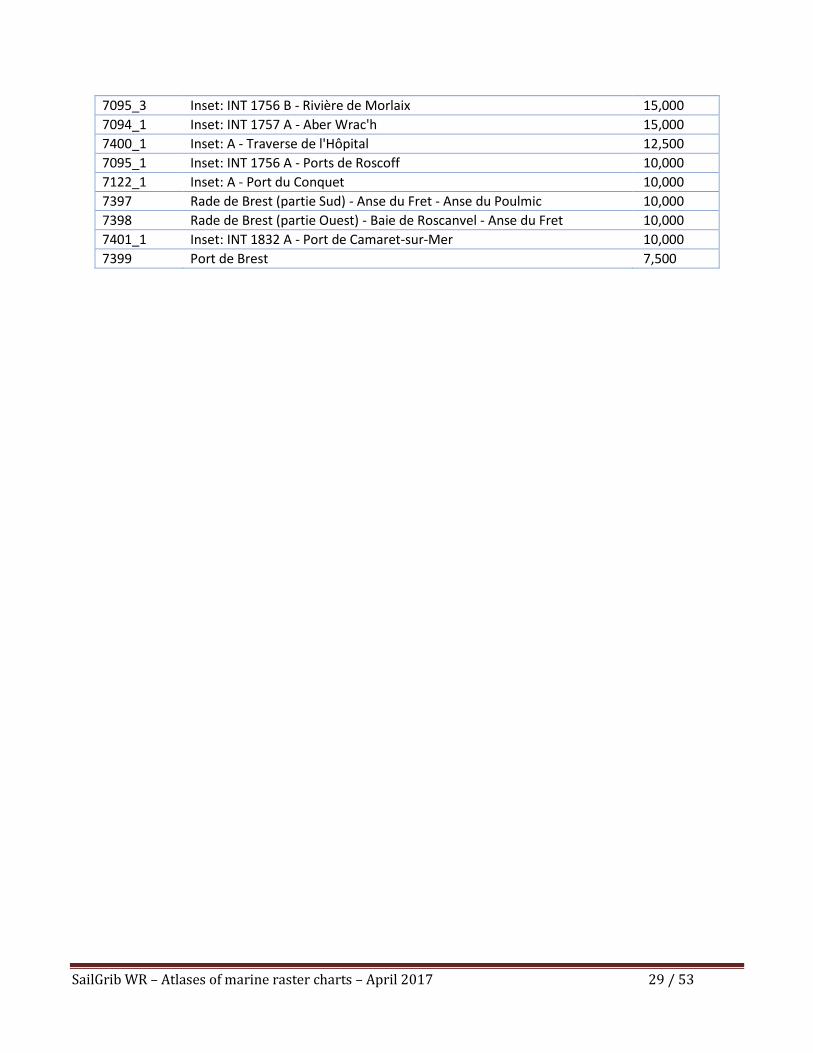
2.3.2. From Brest to Morlaix
The SHOM_BREST_MORLAIX_20170201 atlas includes all coastal maps and details of ports and
anchorages between Brest and Morlaix.
It is offered at the price of €33.00 excl. taxes or equivalent. The inclusive of taxes price depends on
the country of purchase. It is €39.99 for purchases made in France.
Chart Number
Title Scale
6680 De l'île d'Ouessant à l'île de Batz 156,700
7149 Du Goulet de Brest à Portsall - Ile d'Ouessant 49,100
7150 De Portsall à l'Anse de Kernic 48,900
7122 De la Pointe de Saint-Mathieu au phare du Four - Chenal du Four 25,000
7094 Du Phare du Four à l'île Vierge - Port de l'Aber-Wrac'h 25,000
7400 Rade de Brest 22,500
7400_2 Inset: B - Rivière du Faou 22,500
7401 Accès à la Rade de Brest 22,500
7123 Ile Molène - Ile d'Ouessant - Passage du Fromveur 20,000
SailGrib WR – Atlases of marine raster charts – April 2017 29 / 53
7095_3 Inset: INT 1756 B - Rivière de Morlaix 15,000
7094_1 Inset: INT 1757 A - Aber Wrac'h 15,000
7400_1 Inset: A - Traverse de l'Hôpital 12,500
7095_1 Inset: INT 1756 A - Ports de Roscoff 10,000
7122_1 Inset: A - Port du Conquet 10,000
7397 Rade de Brest (partie Sud) - Anse du Fret - Anse du Poulmic 10,000
7398 Rade de Brest (partie Ouest) - Baie de Roscanvel - Anse du Fret 10,000
7401_1 Inset: INT 1832 A - Port de Camaret-sur-Mer 10,000
7399 Port de Brest 7,500
SailGrib WR – Atlases of marine raster charts – April 2017 30 / 53
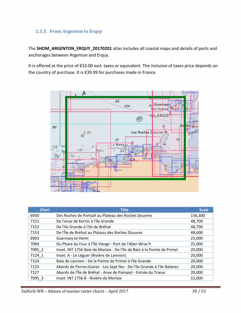
2.3.3. From Argenton to Erquy
The SHOM_ARGENTON_ERQUY_20170201 atlas includes all coastal maps and details of ports and
anchorages between Argenton and Erquy.
It is offered at the price of €33.00 excl. taxes or equivalent. The inclusive of taxes price depends on
the country of purchase. It is €39.99 for purchases made in France.
Chart Number
Title Scale
6930 Des Roches de Portsall au Plateau des Roches Douvres 156,300
7151 De l'anse de Kernic à l'île Grande 48,700
7152 De l'Ile Grande à l'Ile de Bréhat 48,700
7153 De l'Île de Bréhat au Plateau des Roches Douvres 48,600
6903 Guernsey et Herm 25,000
7094 Du Phare du Four à l'île Vierge - Port de l'Aber-Wrac'h 25,000
7095_2 Inset: INT 1756 Baie de Morlaix - De l'île de Batz à la Pointe de Primel 20,000
7124_1 Inset: A - Le Léguer (Rivière de Lannion) 20,000
7124 Baie de Lannion - De la Pointe de Primel à l'île Grande 20,000
7125 Abords de Perros-Guirec - Les Sept Iles - De l'Ile Grande à l'Ile Balanec 20,000
7127 Abords de l'Île de Bréhat - Anse de Paimpol - Entrée du Trieux 20,000
7095_3 Inset: INT 1756 B - Rivière de Morlaix 15,000
SailGrib WR – Atlases of marine raster charts – April 2017 31 / 53
7094_1 Inset: INT 1757 A - Aber Wrac'h 15,000
7095_1 Inset: INT 1756 A - Ports de Roscoff 10,000
7125_1 Inset: C - Port de Perros-Guirec 10,000
7125_2 Inset: B - Port de Ploumanac'h 10,000
7125_3 Inset: A - Mouillages de Trégastel 10,000
7127_1 Inset: INT 1755 A - Port de Lézardrieux - Le Trieux 10,000
7127_2 Inset: INT 1755 B - Port de Paimpol 10,000
7154_1 Inset: Port de Saint-Brieuc Le Légué 10,000
7124_2 Inset: B - Port de Lannion (Le Léguer) 7,500
7124_3 Inset: C - Port de Trébeurden 7,500
7128_1 Inset: B - Port de Binic 7,500
7128_2 Inset: A - Port de Saint-Quay-Portrieux 7,500
7310_1 Inset: A - Port de Dahouët 7,500
7310_2 Inset: B - Port d'Erquy 7,500
SailGrib WR – Atlases of marine raster charts – April 2017 32 / 53
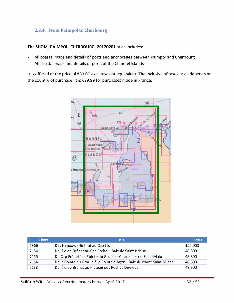
2.3.4. From Paimpol to Cherbourg
The SHOM_PAIMPOL_CHERBOURG_20170201 atlas includes:
- All coastal maps and details of ports and anchorages between Paimpol and Cherbourg.
- All coastal maps and details of ports of the Channel Islands
It is offered at the price of €33.00 excl. taxes or equivalent. The inclusive of taxes price depends on
the country of purchase. It is €39.99 for purchases made in France.
Chart Number
Title Scale
6966 Des Héaux-de-Bréhat au Cap Lévi 155,000
7154 De l'île de Bréhat au Cap Fréhel - Baie de Saint-Brieuc 48,800
7155 Du Cap Fréhel à la Pointe du Grouin - Approches de Saint-Malo 48,800
7156 De la Pointe du Grouin à la Pointe d'Agon - Baie du Mont-Saint-Michel -
Iles Chausey
48,800
7153 De l'Île de Bréhat au Plateau des Roches Douvres 48,600
SailGrib WR – Atlases of marine raster charts – April 2017 33 / 53
7161 Des îles Chausey à Jersey - Plateau des Minquiers 48,500
7157 De la Pointe d'Agon au Cap de Carteret - Passage de la Déroute 48,400
7160 De Jersey à Guernsey 48,300
7158 Du Cap de Carteret au Cap de la Hague - Raz Blanchard 48,000
7159 De Guernsey, Herm et Sark à Alderney - Bancs des Casquets 48,000
6903 Guernsey et Herm 25,000
6904 Guernsey Est, Herm et Sark 25,000
6934 Alderney (Aurigny) et Les Casquets 25,000
6937 Jersey - Côte Nord 25,000
6938 Abords de Saint Hélier 25,000
6939 Jersey - Côte Est 25,000
7128 Baie de Saint-Brieuc (Partie Ouest) - De la Pointe de la Tour à l'Anse
d'Yffiniac
25,000
7310 Baie de Saint-Brieuc (partie Est) - De Dahouët au Cap Fréhel 25,000
7129 Du Cap Fréhel à Saint-Briac-sur-Mer 20,000
7131 Du Hâvre de Rothéneuf à Cancale 20,000
7133_1 Inset: C - Abords de Carteret et Portbail 20,000
7232 Du Nez de Jobourg à la Pointe de Nacqueville 20,000
4233_1 Inset: Du Chêne Vert à l'écluse du Châtelier 15,000
4233 La Rance - De Saint-Malo à l'écluse du Châtelier 15,000
6903_A Inset: Beaucette Marina 15,000
6904_A Inset: Beaucette Marina 15,000
7130 Abords de Saint-Malo - De l'île des Hébihens à la Pointe de la Varde 15,000
7133_2 Inset: F - Havre de Regnéville 15,000
7133_6 Inset: B - Abords de Diélette 15,000
7134 Iles Chausey 15,000
7341 Abords de Granville 15,000
7127_1 Inset: INT 1755 A - Port de Lézardrieux - Le Trieux 10,000
7127_2 Inset: INT 1755 B - Port de Paimpol 10,000
7133_3 Inset: E - Portbail 10,000
7133_4 Inset: D - Carteret 10,000
7133_5 Inset: A - Abords de Goury 10,000
7154_1 Inset: Port de Saint-Brieuc Le Légué 10,000
7086 Rade de Cherbourg 7,500
7090_1 Inset: A - Port de Barfleur 7,500
7090_2 Inset: B - Port de Saint-Vaast-la-Hougue 7,500
7128_1 Inset: B - Port de Binic 7,500
7128_2 Inset: A - Port de Saint-Quay-Portrieux 7,500
7131_1 Inset: A - Port de Cancale 7,500
7232_1 Inset: A - Abords d'Omonville-La-Rogue 7,500
7310_1 Inset: A - Port de Dahouët 7,500
7310_2 Inset: B - Port d'Erquy 7,500
7134_1 Inset: A - Sound de Chausey 5,000
SailGrib WR – Atlases of marine raster charts – April 2017 34 / 53
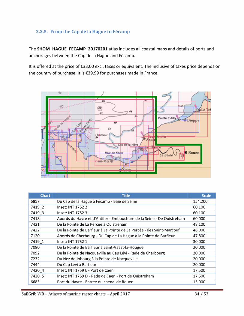
2.3.5. From the Cap de la Hague to Fécamp
The SHOM_HAGUE_FECAMP_20170201 atlas includes all coastal maps and details of ports and
anchorages between the Cap de la Hague and Fécamp.
It is offered at the price of €33.00 excl. taxes or equivalent. The inclusive of taxes price depends on
the country of purchase. It is €39.99 for purchases made in France.
Chart Number
Title Scale
6857 Du Cap de la Hague à Fécamp - Baie de Seine 154,200
7419_2 Inset: INT 1752 2 60,100
7419_3 Inset: INT 1752 3 60,100
7418 Abords du Havre et d'Antifer - Embouchure de la Seine - De Ouistreham
au Cap d'Antifer
60,000
7421 De la Pointe de La Percée à Ouistreham 48,100
7422 De la Pointe de Barfleur à La Pointe de La Percée - Iles Saint-Marcouf 48,000
7120 Abords de Cherbourg - Du Cap de La Hague à la Pointe de Barfleur 47,800
7419_1 Inset: INT 1752 1 30,000
7090 De la Pointe de Barfleur à Saint-Vaast-la-Hougue 20,000
7092 De la Pointe de Nacqueville au Cap Lévi - Rade de Cherbourg 20,000
7232 Du Nez de Jobourg à la Pointe de Nacqueville 20,000
7444 Du Cap Lévi à Barfleur 20,000
7420_4 Inset: INT 1759 E - Port de Caen 17,500
7420_5 Inset: INT 1759 D - Rade de Caen - Port de Ouistreham 17,500
6683 Port du Havre - Entrée du chenal de Rouen 15,000
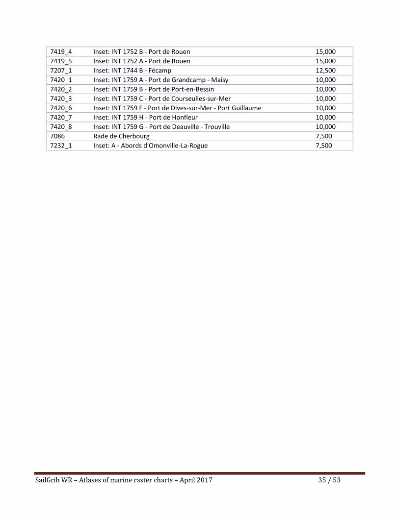
SailGrib WR – Atlases of marine raster charts – April 2017 35 / 53
7419_4 Inset: INT 1752 B - Port de Rouen 15,000
7419_5 Inset: INT 1752 A - Port de Rouen 15,000
7207_1 Inset: INT 1744 B - Fécamp 12,500
7420_1 Inset: INT 1759 A - Port de Grandcamp - Maisy 10,000
7420_2 Inset: INT 1759 B - Port de Port-en-Bessin 10,000
7420_3 Inset: INT 1759 C - Port de Courseulles-sur-Mer 10,000
7420_6 Inset: INT 1759 F - Port de Dives-sur-Mer - Port Guillaume 10,000
7420_7 Inset: INT 1759 H - Port de Honfleur 10,000
7420_8 Inset: INT 1759 G - Port de Deauville - Trouville 10,000
7086 Rade de Cherbourg 7,500
7232_1 Inset: A - Abords d'Omonville-La-Rogue 7,500
SailGrib WR – Atlases of marine raster charts – April 2017 36 / 53
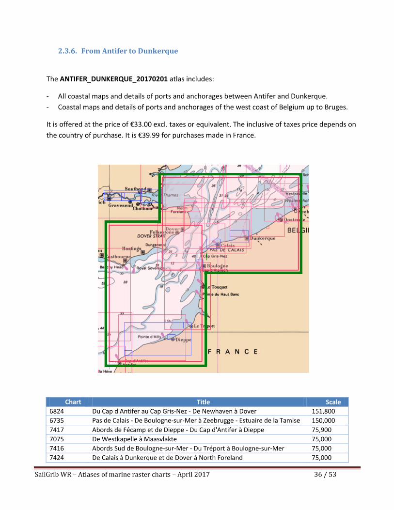
2.3.6. From Antifer to Dunkerque
The ANTIFER_DUNKERQUE_20170201 atlas includes:
- All coastal maps and details of ports and anchorages between Antifer and Dunkerque.
- Coastal maps and details of ports and anchorages of the west coast of Belgium up to Bruges.
It is offered at the price of €33.00 excl. taxes or equivalent. The inclusive of taxes price depends on
the country of purchase. It is €39.99 for purchases made in France.
Chart Number
Title Scale
6824 Du Cap d'Antifer au Cap Gris-Nez - De Newhaven à Dover 151,800
6735 Pas de Calais - De Boulogne-sur-Mer à Zeebrugge - Estuaire de la Tamise
(Thames)
150,000
7417 Abords de Fécamp et de Dieppe - Du Cap d'Antifer à Dieppe 75,900
7075 De Westkapelle à Maasvlakte 75,000
7416 Abords Sud de Boulogne-sur-Mer - Du Tréport à Boulogne-sur-Mer 75,000
7424 De Calais à Dunkerque et de Dover à North Foreland 75,000
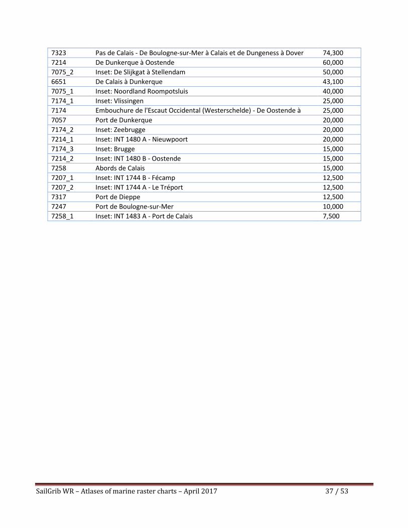
SailGrib WR – Atlases of marine raster charts – April 2017 37 / 53
7323 Pas de Calais - De Boulogne-sur-Mer à Calais et de Dungeness à Dover 74,300
7214 De Dunkerque à Oostende 60,000
7075_2 Inset: De Slijkgat à Stellendam 50,000
6651 De Calais à Dunkerque 43,100
7075_1 Inset: Noordland Roompotsluis 40,000
7174_1 Inset: Vlissingen 25,000
7174 Embouchure de l'Escaut Occidental (Westerschelde) - De Oostende à
Westkapelle
25,000
7057 Port de Dunkerque 20,000
7174_2 Inset: Zeebrugge 20,000
7214_1 Inset: INT 1480 A - Nieuwpoort 20,000
7174_3 Inset: Brugge 15,000
7214_2 Inset: INT 1480 B - Oostende 15,000
7258 Abords de Calais 15,000
7207_1 Inset: INT 1744 B - Fécamp 12,500
7207_2 Inset: INT 1744 A - Le Tréport 12,500
7317 Port de Dieppe 12,500
7247 Port de Boulogne-sur-Mer 10,000
7258_1 Inset: INT 1483 A - Port de Calais 7,500
SailGrib WR – Atlases of marine raster charts – April 2017 38 / 53
3. UKHO
The atlases are derived from UKHO raster marine charts and are updated once a year.
The name of the atlas indicates its creation date. Thus the UKHO_UK_IRELAND_20170201 atlas
published on 01 February 2017 will be updated once in 2018.
The user can update an atlas in the year following its purchase.
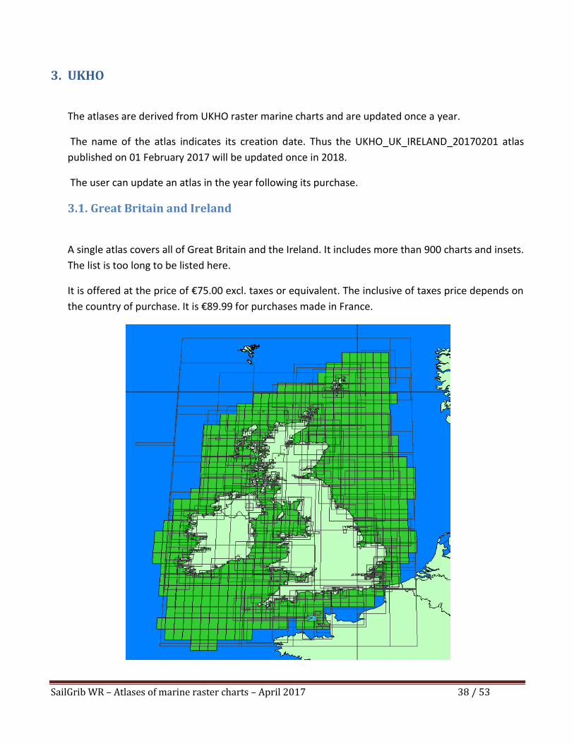
3.1. Great Britain and Ireland
A single atlas covers all of Great Britain and the Ireland. It includes more than 900 charts and insets.
The list is too long to be listed here.
It is offered at the price of €75.00 excl. taxes or equivalent. The inclusive of taxes price depends on
the country of purchase. It is €89.99 for purchases made in France.
SailGrib WR – Atlases of marine raster charts – April 2017 39 / 53
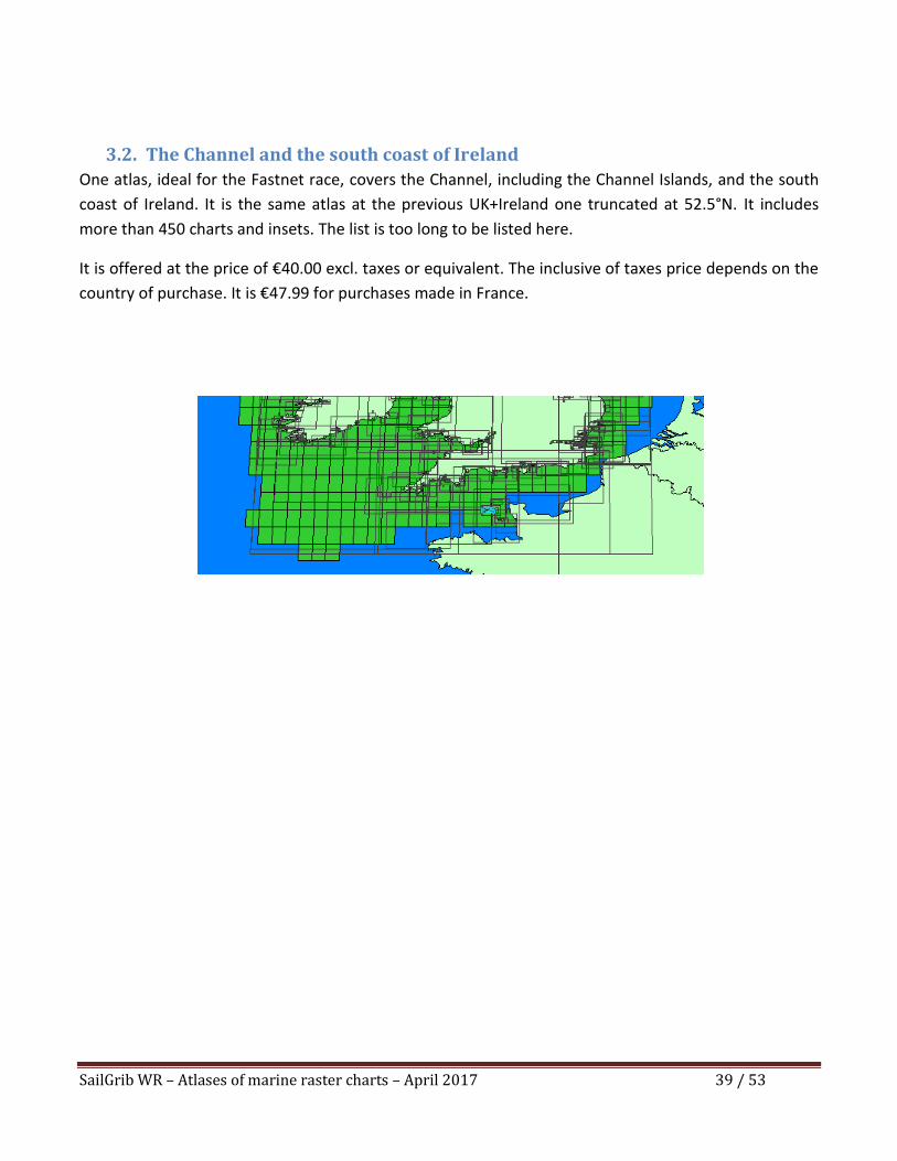
3.2. The Channel and the south coast of Ireland
One atlas, ideal for the Fastnet race, covers the Channel, including the Channel Islands, and the south
coast of Ireland. It is the same atlas at the previous UK+Ireland one truncated at 52.5°N. It includes
more than 450 charts and insets. The list is too long to be listed here.
It is offered at the price of €40.00 excl. taxes or equivalent. The inclusive of taxes price depends on the
country of purchase. It is €47.99 for purchases made in France.

SailGrib WR – Atlases of marine raster charts – April 2017 40 / 53
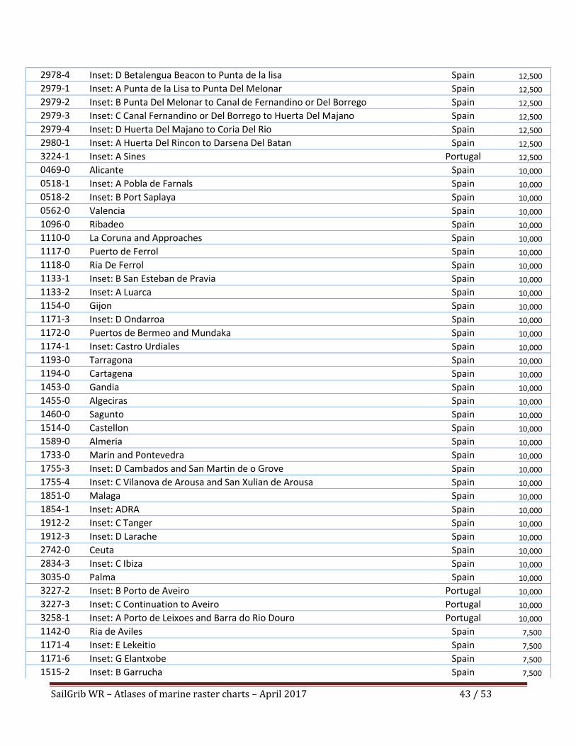
3.3. Spain and Portugal
A single atlas covers Spain and Portugal including the Baleares. It includes 165 charts and insets.
It is offered at the price of €75.00 excl. taxes or equivalent. The inclusive of taxes price depends on the
country of purchase. It is €89.99 for purchases made in France.
Chart Title Country Scale
3132-0 Strait of Gibraltar to Arquipelago da Madeira Spain 1,250,000
2717-0 Strait of Gibraltar to Barcelona and Alger including Islas Baleares Spain 1,100,000
0087-0 Cabo Finisterre to the Strait of Gibraltar Spain 1,000,000
1104-0 Bay of Biscay Spain 1,000,000
0091-0 Cabo de Sao Vicente to the Strait of Gibraltar Spain 375,000
0773-0 Strait of Gibraltar to Isla de Alboran Spain 300,000
0774-0 Motril to Cartagena including Isla de Alboran Spain 300,000
1700-0 Cartagena to Cabo de San Antonio including Isla Formentera Spain 300,000
1701-0 Cabo de San Antonio to Vilanova i la Geltru including Islas de Ibiza and Formentera
Spain 300,000
1702-0 Ibiza- Formentera and Southern Mallorca Spain 300,000
1703-0 Mallorca and Menorca Spain 300,000
1704-0 Punta de la Bana to Islas Medas Spain 300,000
1909-0 Ile Plane to Cherchell UK 300,000
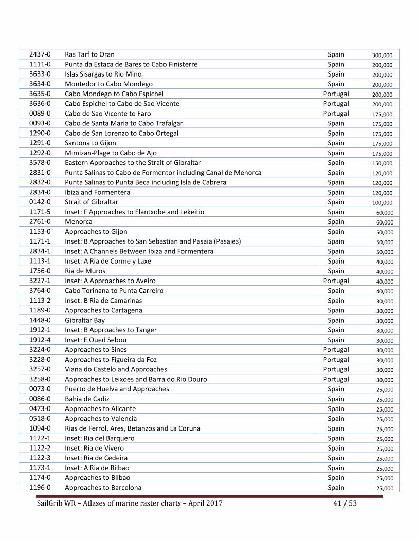
SailGrib WR – Atlases of marine raster charts – April 2017 41 / 53
2437-0 Ras Tarf to Oran Spain 300,000
1111-0 Punta da Estaca de Bares to Cabo Finisterre Spain 200,000
3633-0 Islas Sisargas to Rio Mino Spain 200,000
3634-0 Montedor to Cabo Mondego Spain 200,000
3635-0 Cabo Mondego to Cabo Espichel Portugal 200,000
3636-0 Cabo Espichel to Cabo de Sao Vicente Portugal 200,000
0089-0 Cabo de Sao Vicente to Faro Portugal 175,000
0093-0 Cabo de Santa Maria to Cabo Trafalgar Spain 175,000
1290-0 Cabo de San Lorenzo to Cabo Ortegal Spain 175,000
1291-0 Santona to Gijon Spain 175,000
1292-0 Mimizan-Plage to Cabo de Ajo Spain 175,000
3578-0 Eastern Approaches to the Strait of Gibraltar Spain 150,000
2831-0 Punta Salinas to Cabo de Formentor including Canal de Menorca Spain 120,000
2832-0 Punta Salinas to Punta Beca including Isla de Cabrera Spain 120,000
2834-0 Ibiza and Formentera Spain 120,000
0142-0 Strait of Gibraltar Spain 100,000
1171-5 Inset: F Approaches to Elantxobe and Lekeitio Spain 60,000
2761-0 Menorca Spain 60,000
1153-0 Approaches to Gijon Spain 50,000
1171-1 Inset: B Approaches to San Sebastian and Pasaia (Pasajes) Spain 50,000
2834-1 Inset: A Channels Between Ibiza and Formentera Spain 50,000
1113-1 Inset: A Ria de Corme y Laxe Spain 40,000
1756-0 Ria de Muros Spain 40,000
3227-1 Inset: A Approaches to Aveiro Portugal 40,000
3764-0 Cabo Torinana to Punta Carreiro Spain 40,000
1113-2 Inset: B Ria de Camarinas Spain 30,000
1189-0 Approaches to Cartagena Spain 30,000
1448-0 Gibraltar Bay Spain 30,000
1912-1 Inset: B Approaches to Tanger Spain 30,000
1912-4 Inset: E Oued Sebou Spain 30,000
3224-0 Approaches to Sines Portugal 30,000
3228-0 Approaches to Figueira da Foz Portugal 30,000
3257-0 Viana do Castelo and Approaches Portugal 30,000
3258-0 Approaches to Leixoes and Barra do Rio Douro Portugal 30,000
0073-0 Puerto de Huelva and Approaches Spain 25,000
0086-0 Bahia de Cadiz Spain 25,000
0473-0 Approaches to Alicante Spain 25,000
0518-0 Approaches to Valencia Spain 25,000
1094-0 Rias de Ferrol, Ares, Betanzos and La Coruna Spain 25,000
1122-1 Inset: Ria del Barquero Spain 25,000
1122-2 Inset: Ria de Vivero Spain 25,000
1122-3 Inset: Ria de Cedeira Spain 25,000
1173-1 Inset: A Ria de Bilbao Spain 25,000
1174-0 Approaches to Bilbao Spain 25,000
1196-0 Approaches to Barcelona Spain 25,000
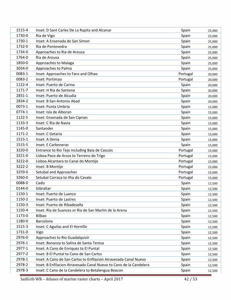
SailGrib WR – Atlases of marine raster charts – April 2017 42 / 53
1515-4 Inset: D Sant Carles De La Rapita and Alcanar Spain 25,000
1730-0 Ria de Vigo Spain 25,000
1730-1 Inset: A Ensenada de San Simon Spain 25,000
1732-0 Ria de Pontevedra Spain 25,000
1734-0 Approaches to Ria de Arousa Spain 25,000
1764-0 Ria de Arousa Spain 25,000
1850-0 Approaches to Malaga Spain 25,000
3034-0 Approaches to Palma Spain 25,000
0083-1 Inset: Approaches to Faro and Olhao Portugal 20,000
0083-2 Inset: Portimao Portugal 20,000
1122-4 Inset: Puerto de Carino Spain 20,000
1171-7 Inset: H Ria de Santona Spain 20,000
2831-1 Inset: Puerto de Alcudia Spain 20,000
2834-2 Inset: B San Antonio Abad Spain 20,000
0073-1 Inset: Punta Umbria Spain 15,000
0774-1 Inset: Isla de Alboran Spain 15,000
1122-5 Inset: Ensenada de San Ciprian Spain 15,000
1133-3 Inset: C Ria de Navia Spain 15,000
1145-0 Santander Spain 15,000
1171-2 Inset: C Getaria Spain 15,000
1515-1 Inset: A Denia Spain 15,000
1515-5 Inset: E Carboneras Spain 15,000
3220-0 Entrance to Rio Tejo including Baia de Cascais Portugal 15,000
3221-0 Lisboa Paco de Arcos to Terreiro do Trigo Portugal 15,000
3222-0 Lisboa Alcantara to Canal do Montijo Portugal 15,000
3222-2 Inset: B Montijo Portugal 15,000
3259-0 Setubal and Approaches Portugal 15,000
3260-0 Setubal Carraca to Ilha do Cavalo Portugal 15,000
0088-0 Cadiz Spain 12,500
0144-0 Gibraltar Spain 12,500
1150-1 Inset: Puerto de Luanco Spain 12,500
1150-2 Inset: Puerto de Lastres Spain 12,500
1150-3 Inset: Puerto de Ribadesella Spain 12,500
1150-4 Inset: Ria de Suances or Ria de San Martin de la Arena Spain 12,500
1173-0 Bilbao Spain 12,500
1180-0 Barcelona Spain 12,500
1515-3 Inset: C Aguilas and El Hornillo Spain 12,500
1731-0 Vigo Spain 12,500
2976-0 Approaches to Rio Guadalquivir Spain 12,500
2976-1 Inset: Bonanza to Salina de Santa Teresa Spain 12,500
2977-1 Inset: A Cano de Enriquez to El Puntal Spain 12,500
2977-2 Inset: B El Puntal to Cano de San Carlos Spain 12,500
2978-1 Inset: A Cano de San Carlos to Enfilacion Atravesada Canal Nuevo Spain 12,500
2978-2 Inset: B Enfilacion Atravesada Canal Nuevo to Cano de la Candelera Spain 12,500
2978-3 Inset: C Cano de la Candelera to Betalengua Beacon Spain 12,500
SailGrib WR – Atlases of marine raster charts – April 2017 43 / 53
2978-4 Inset: D Betalengua Beacon to Punta de la lisa Spain 12,500
2979-1 Inset: A Punta de la Lisa to Punta Del Melonar Spain 12,500
2979-2 Inset: B Punta Del Melonar to Canal de Fernandino or Del Borrego Spain 12,500
2979-3 Inset: C Canal Fernandino or Del Borrego to Huerta Del Majano Spain 12,500
2979-4 Inset: D Huerta Del Majano to Coria Del Rio Spain 12,500
2980-1 Inset: A Huerta Del Rincon to Darsena Del Batan Spain 12,500
3224-1 Inset: A Sines Portugal 12,500
0469-0 Alicante Spain 10,000
0518-1 Inset: A Pobla de Farnals Spain 10,000
0518-2 Inset: B Port Saplaya Spain 10,000
0562-0 Valencia Spain 10,000
1096-0 Ribadeo Spain 10,000
1110-0 La Coruna and Approaches Spain 10,000
1117-0 Puerto de Ferrol Spain 10,000
1118-0 Ria De Ferrol Spain 10,000
1133-1 Inset: B San Esteban de Pravia Spain 10,000
1133-2 Inset: A Luarca Spain 10,000
1154-0 Gijon Spain 10,000
1171-3 Inset: D Ondarroa Spain 10,000
1172-0 Puertos de Bermeo and Mundaka Spain 10,000
1174-1 Inset: Castro Urdiales Spain 10,000
1193-0 Tarragona Spain 10,000
1194-0 Cartagena Spain 10,000
1453-0 Gandia Spain 10,000
1455-0 Algeciras Spain 10,000
1460-0 Sagunto Spain 10,000
1514-0 Castellon Spain 10,000
1589-0 Almeria Spain 10,000
1733-0 Marin and Pontevedra Spain 10,000
1755-3 Inset: D Cambados and San Martin de o Grove Spain 10,000
1755-4 Inset: C Vilanova de Arousa and San Xulian de Arousa Spain 10,000
1851-0 Malaga Spain 10,000
1854-1 Inset: ADRA Spain 10,000
1912-2 Inset: C Tanger Spain 10,000
1912-3 Inset: D Larache Spain 10,000
2742-0 Ceuta Spain 10,000
2834-3 Inset: C Ibiza Spain 10,000
3035-0 Palma Spain 10,000
3227-2 Inset: B Porto de Aveiro Portugal 10,000
3227-3 Inset: C Continuation to Aveiro Portugal 10,000
3258-1 Inset: A Porto de Leixoes and Barra do Rio Douro Portugal 10,000
1142-0 Ria de Aviles Spain 7,500
1171-4 Inset: E Lekeitio Spain 7,500
1171-6 Inset: G Elantxobe Spain 7,500
1515-2 Inset: B Garrucha Spain 7,500
SailGrib WR – Atlases of marine raster charts – April 2017 44 / 53
1755-1 Inset: A Santa Uxia de Ribeira Spain 7,500
1755-2 Inset: B A Pobra do Caraminal Spain 7,500
1762-0 Vilagarcia de Arousa Spain 7,500
1854-2 Inset: MOTRIL Spain 7,500
2762-0 Mahon Spain 7,500
2980-2 Inset: B Corta de Tablada to Darsena Del Batan Spain 7,500
2980-3 Inset: C Darsena Del Batan to Sevilla Spain 7,500
3222-1 Inset: A Azinheira Portugal 7,500
3228-1 Inset: A Figueira da Foz Portugal 7,500
3228-2 Inset: B Continuation of Figueira da Foz Portugal 7,500
3257-1 Inset: A Viana do Castelo Portugal 7,500
1157-0 Pasaia (Pasajes) and Approaches Spain 5,000
0045-0 Gibraltar Harbour UK 3,600
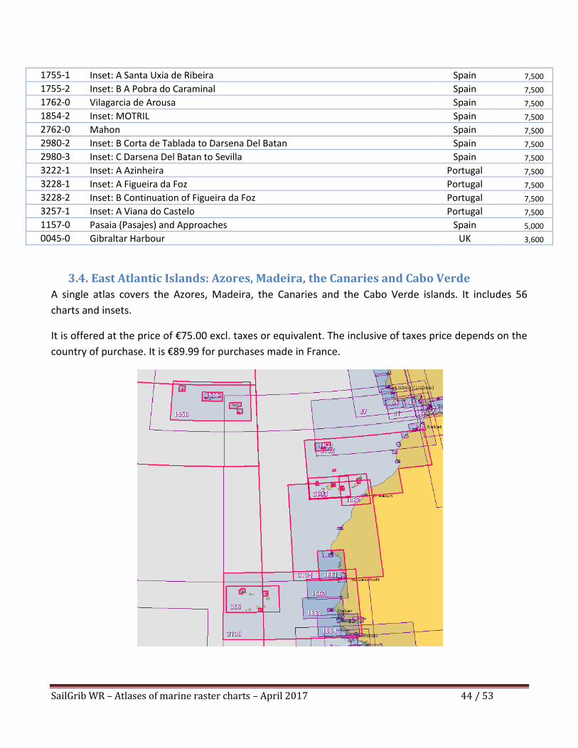
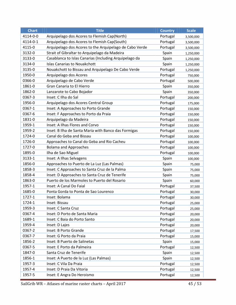
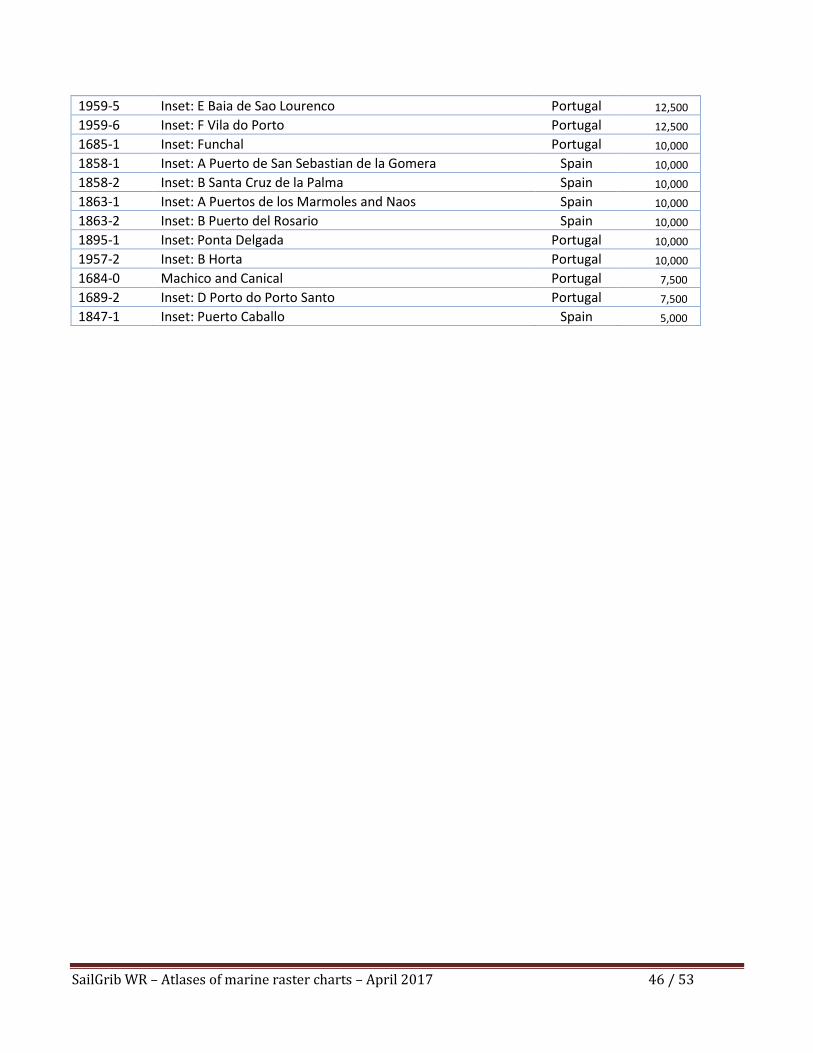
3.4. East Atlantic Islands: Azores, Madeira, the Canaries and Cabo Verde
A single atlas covers the Azores, Madeira, the Canaries and the Cabo Verde islands. It includes 56
charts and insets.
It is offered at the price of €75.00 excl. taxes or equivalent. The inclusive of taxes price depends on the
country of purchase. It is €89.99 for purchases made in France.
SailGrib WR – Atlases of marine raster charts – April 2017 45 / 53
Chart Title Country Scale
4114-0-0 Arquipelago dos Acores to Flemish Cap(North) Portugal 3,500,000
4114-0-1 Arquipelago dos Acores to Flemish Cap(South) Portugal 3,500,000
4115-0 Arquipelago dos Acores to the Arquipelago de Cabo Verde Portugal 3,500,000
3132-0 Strait of Gibraltar to Arquipelago da Madeira Spain 1,250,000
3133-0 Casablanca to Islas Canarias (Including Arquipelago da Madeira)
Spain 1,250,000
3134-0 Islas Canarias to Nouakchott Spain 1,250,000
3135-0 Nouakchott to Bissau and Arquipelago De Cabo Verde Portugal 1,250,000
1950-0 Arquipelago dos Acores Portugal 750,000
0366-0 Arquipelago de Cabo Verde Portugal 500,000
1861-0 Gran Canaria to El Hierro Spain 350,000
1862-0 Lanzarote to Cabo Bojador Spain 350,000
0367-3 Inset: C Ilha do Sal Portugal 200,000
1956-0 Arquipelago dos Acores Central Group Portugal 175,000
0367-1 Inset: A Approaches to Porto Grande Portugal 150,000
0367-6 Inset: F Approaches to Porto da Praia Portugal 150,000
1831-0 Arquipelago da Madeira Portugal 150,000
1959-1 Inset: A Ilhas Flores and Corvo Portugal 150,000
1959-2 Inset: B Ilha de Santa Maria with Banco das Formigas Portugal 150,000
1724-0 Canal do Geba and Bissau Portugal 100,000
1726-0 Approaches to Canal do Geba and Rio Cacheu Portugal 100,000
1727-0 Bolama and Approaches Portugal 100,000
1895-0 Ilha de Sao Miguel Portugal 100,000
3133-1 Inset: A Ilhas Selvagens Spain 100,000
1856-0 Approaches to Puerto de La Luz (Las Palmas) Spain 75,000
1858-3 Inset: C Approaches to Santa Cruz de la Palma Spain 75,000
1858-4 Inset: D Approaches to Santa Cruz de Tenerife Spain 75,000
1863-0 Puerto de los Marmoles to Puerto del Rosario Spain 60,000
1957-1 Inset: A Canal Do Faial Portugal 37,500
1685-0 Ponta Gorda to Ponta de Sao Lourenco Portugal 30,000
1727-1 Inset: Bolama Portugal 30,000
1724-1 Inset: Bissau Portugal 25,000
1959-3 Inset: C Santa Cruz Portugal 25,000
0367-4 Inset: D Porto de Santa Maria Portugal 20,000
1689-1 Inset: C Baia do Porto Santo Portugal 20,000
1959-4 Inset: D Lajes Portugal 20,000
0367-2 Inset: B Porto Grande Portugal 17,500
0367-7 Inset: G Porto da Praia Portugal 15,000
1856-2 Inset: B Puerto de Salinetas Spain 15,000
0367-5 Inset: E Porto da Palmeira Portugal 12,500
1847-0 Santa Cruz de Tenerife Spain 12,500
1856-1 Inset: A Puerto de la Luz (Las Palmas) Spain 12,500
1957-3 Inset: C Vila Da Praia Portugal 12,500
1957-4 Inset: D Praia Da Vitoria Portugal 12,500
1957-5 Inset: E Angra Do Heroismo Portugal 12,500
SailGrib WR – Atlases of marine raster charts – April 2017 46 / 53
1959-5 Inset: E Baia de Sao Lourenco Portugal 12,500
1959-6 Inset: F Vila do Porto Portugal 12,500
1685-1 Inset: Funchal Portugal 10,000
1858-1 Inset: A Puerto de San Sebastian de la Gomera Spain 10,000
1858-2 Inset: B Santa Cruz de la Palma Spain 10,000
1863-1 Inset: A Puertos de los Marmoles and Naos Spain 10,000
1863-2 Inset: B Puerto del Rosario Spain 10,000
1895-1 Inset: Ponta Delgada Portugal 10,000
1957-2 Inset: B Horta Portugal 10,000
1684-0 Machico and Canical Portugal 7,500
1689-2 Inset: D Porto do Porto Santo Portugal 7,500
1847-1 Inset: Puerto Caballo Spain 5,000
SailGrib WR – Atlases of marine raster charts – April 2017 47 / 53
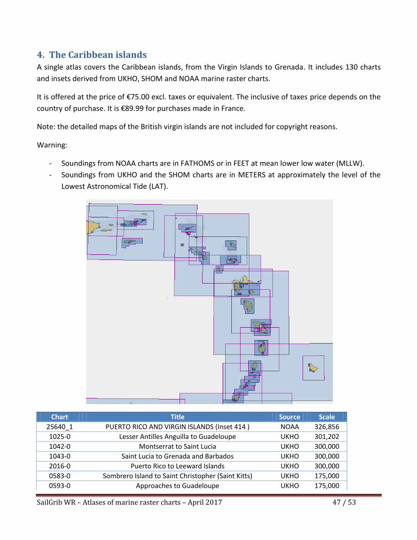
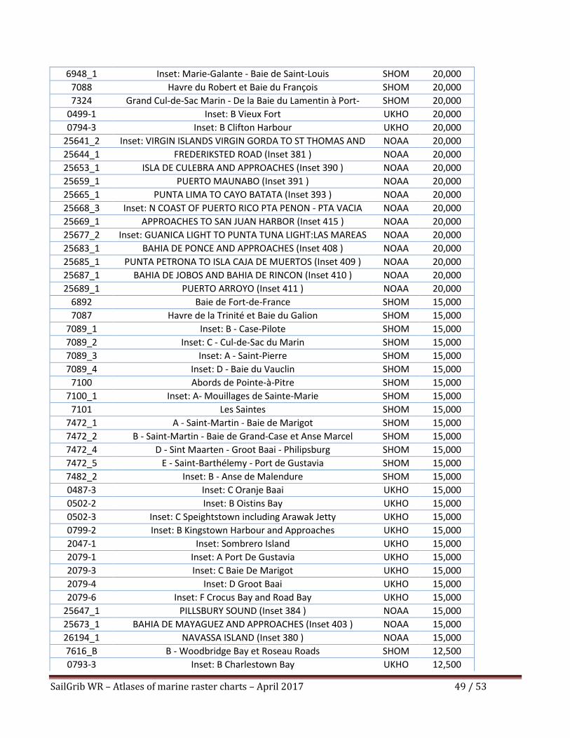
4. The Caribbean islands A single atlas covers the Caribbean islands, from the Virgin Islands to Grenada. It includes 130 charts
and insets derived from UKHO, SHOM and NOAA marine raster charts.
It is offered at the price of €75.00 excl. taxes or equivalent. The inclusive of taxes price depends on the
country of purchase. It is €89.99 for purchases made in France.
Note: the detailed maps of the British virgin islands are not included for copyright reasons.
Warning:
- Soundings from NOAA charts are in FATHOMS or in FEET at mean lower low water (MLLW).
- Soundings from UKHO and the SHOM charts are in METERS at approximately the level of the
Lowest Astronomical Tide (LAT).
Chart Title Source Scale
25640_1 PUERTO RICO AND VIRGIN ISLANDS (Inset 414 ) NOAA 326,856
1025-0 Lesser Antilles Anguilla to Guadeloupe UKHO 301,202
1042-0 Montserrat to Saint Lucia UKHO 300,000
1043-0 Saint Lucia to Grenada and Barbados UKHO 300,000
2016-0 Puerto Rico to Leeward Islands UKHO 300,000
0583-0 Sombrero Island to Saint Christopher (Saint Kitts) UKHO 175,000
0593-0 Approaches to Guadeloupe UKHO 175,000
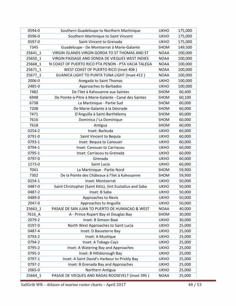
SailGrib WR – Atlases of marine raster charts – April 2017 48 / 53
0594-0 Southern Guadeloupe to Northern Martinique UKHO 175,000
0596-0 Southern Martinique to Saint Vincent UKHO 175,000
0597-0 Saint Vincent to Grenada UKHO 175,000
7345 Guadeloupe - De Montserrat à Marie-Galante SHOM 149,500
25641_1 VIRGIN ISLANDS VIRGIN GORDA TO ST THOMAS AND ST CROIX (Inset 386 )
NOAA 100,000
25650_1 VIRGIN PASSAGE AND SONDA DE VIEQUES WEST INDIES (Inset 398 )
NOAA 100,000
25668_1 N COAST OF PUERTO RICO PTA PENON - PTA VACIA TALEGA (Inset 400 )
NOAA 100,000
25671_1 WEST COAST OF PUERTO RICO (Inset 406 ) NOAA 100,000
25677_1 GUANICA LIGHT TO PUNTA TUNA LIGHT (Inset 412 ) NOAA 100,000
2006-0 Anegada to Saint Thomas UKHO 100,000
2485-0 Approaches to Barbados UKHO 100,000
7482 De l'Ilet à Kahouanne aux Saintes SHOM 60,400
6948 De Pointe-à-Pitre à Marie-Galante - Canal des Saintes SHOM 60,100
6738 La Martinique - Partie Sud SHOM 60,000
7208 De Marie-Galante à la Désirade SHOM 60,000
7471 D'Anguilla à Saint-Barthélemy SHOM 60,000
7616 Dominica / La Dominique SHOM 60,000
7618 Antigua SHOM 60,000
0254-2 Inset: Barbuda UKHO 60,000
0791-0 Saint Vincent to Bequia UKHO 60,000
0793-1 Inset: Bequia to Canouan UKHO 60,000
0794-1 Inset: Canouan to Carriacou UKHO 60,000
0795-1 Inset: Carriacou to Grenada UKHO 60,000
0797-0 Grenada UKHO 60,000
1273-0 Saint Lucia UKHO 60,000
7041 La Martinique - Partie Nord SHOM 59,900
7302 De la Pointe des Châteaux à l'Ilet à Kahouanne SHOM 59,900
0254-1 Inset: Montserrat UKHO 50,000
0487-0 Saint Christopher (Saint Kitts), Sint Eustatius and Saba UKHO 50,000
0487-2 Inset: B Saba UKHO 50,000
0489-0 Approaches to Nevis UKHO 50,000
2047-0 Approaches to Anguilla UKHO 50,000
25663_1 PASAJE DE SAN JUAN TO PUERTO DE HUMACAO & WEST ISLA DE VIEQUES (Inset 397 )
NOAA 40,000
7616_A A - Prince Rupert Bay et Douglas Bay SHOM 30,000
2079-2 Inset: B Simson Baai UKHO 30,000
0197-0 North West Approaches to Saint Lucia UKHO 25,000
0487-4 Inset: D Basseterre Bay UKHO 25,000
0793-2 Inset: A Mustique UKHO 25,000
0794-2 Inset: A Tobago Cays UKHO 25,000
0795-2 Inset: A Watering Bay and Approaches UKHO 25,000
0795-3 Inset: B Hillsborough Bay UKHO 25,000
0797-1 Inset: A Saint David's Harbour to Prickly Bay UKHO 25,000
0797-2 Inset: B Grenada Bay and Approaches UKHO 25,000
2065-0 Northern Antigua UKHO 25,000
25664_1 PASAJE DE VIEQUES AND RADAS ROOSEVELT (Inset 395 ) NOAA 25,000
SailGrib WR – Atlases of marine raster charts – April 2017 49 / 53
6948_1 Inset: Marie-Galante - Baie de Saint-Louis SHOM 20,000
7088 Havre du Robert et Baie du François SHOM 20,000
7324 Grand Cul-de-Sac Marin - De la Baie du Lamentin à Port-Louis
SHOM 20,000
0499-1 Inset: B Vieux Fort UKHO 20,000
0794-3 Inset: B Clifton Harbour UKHO 20,000
25641_2 Inset: VIRGIN ISLANDS VIRGIN GORDA TO ST THOMAS AND ST CROIX:KRANOAAE LAGOON CHANNEL (Inset 387 )
NOAA 20,000
25644_1 FREDERIKSTED ROAD (Inset 381 ) NOAA 20,000
25653_1 ISLA DE CULEBRA AND APPROACHES (Inset 390 ) NOAA 20,000
25659_1 PUERTO MAUNABO (Inset 391 ) NOAA 20,000
25665_1 PUNTA LIMA TO CAYO BATATA (Inset 393 ) NOAA 20,000
25668_3 Inset: N COAST OF PUERTO RICO PTA PENON - PTA VACIA TALEGA:PUERTO ARECIBO (Inset 402 )
NOAA 20,000
25669_1 APPROACHES TO SAN JUAN HARBOR (Inset 415 ) NOAA 20,000
25677_2 Inset: GUANICA LIGHT TO PUNTA TUNA LIGHT:LAS MAREAS (Inset 413 )
NOAA 20,000
25683_1 BAHIA DE PONCE AND APPROACHES (Inset 408 ) NOAA 20,000
25685_1 PUNTA PETRONA TO ISLA CAJA DE MUERTOS (Inset 409 ) NOAA 20,000
25687_1 BAHIA DE JOBOS AND BAHIA DE RINCON (Inset 410 ) NOAA 20,000
25689_1 PUERTO ARROYO (Inset 411 ) NOAA 20,000
6892 Baie de Fort-de-France SHOM 15,000
7087 Havre de la Trinité et Baie du Galion SHOM 15,000
7089_1 Inset: B - Case-Pilote SHOM 15,000
7089_2 Inset: C - Cul-de-Sac du Marin SHOM 15,000
7089_3 Inset: A - Saint-Pierre SHOM 15,000
7089_4 Inset: D - Baie du Vauclin SHOM 15,000
7100 Abords de Pointe-à-Pitre SHOM 15,000
7100_1 Inset: A- Mouillages de Sainte-Marie SHOM 15,000
7101 Les Saintes SHOM 15,000
7472_1 A - Saint-Martin - Baie de Marigot SHOM 15,000
7472_2 B - Saint-Martin - Baie de Grand-Case et Anse Marcel SHOM 15,000
7472_4 D - Sint Maarten - Groot Baai - Philipsburg SHOM 15,000
7472_5 E - Saint-Barthélemy - Port de Gustavia SHOM 15,000
7482_2 Inset: B - Anse de Malendure SHOM 15,000
0487-3 Inset: C Oranje Baai UKHO 15,000
0502-2 Inset: B Oistins Bay UKHO 15,000
0502-3 Inset: C Speightstown including Arawak Jetty UKHO 15,000
0799-2 Inset: B Kingstown Harbour and Approaches UKHO 15,000
2047-1 Inset: Sombrero Island UKHO 15,000
2079-1 Inset: A Port De Gustavia UKHO 15,000
2079-3 Inset: C Baie De Marigot UKHO 15,000
2079-4 Inset: D Groot Baai UKHO 15,000
2079-6 Inset: F Crocus Bay and Road Bay UKHO 15,000
25647_1 PILLSBURY SOUND (Inset 384 ) NOAA 15,000
25673_1 BAHIA DE MAYAGUEZ AND APPROACHES (Inset 403 ) NOAA 15,000
26194_1 NAVASSA ISLAND (Inset 380 ) NOAA 15,000
7616_B B - Woodbridge Bay et Roseau Roads SHOM 12,500
0793-3 Inset: B Charlestown Bay UKHO 12,500
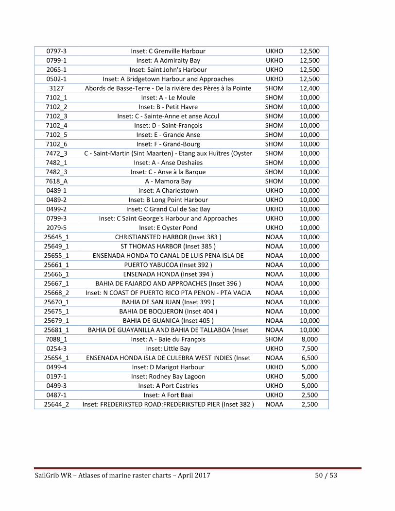
SailGrib WR – Atlases of marine raster charts – April 2017 50 / 53
0797-3 Inset: C Grenville Harbour UKHO 12,500
0799-1 Inset: A Admiralty Bay UKHO 12,500
2065-1 Inset: Saint John's Harbour UKHO 12,500
0502-1 Inset: A Bridgetown Harbour and Approaches UKHO 12,500
3127 Abords de Basse-Terre - De la rivière des Pères à la Pointe du Vieux Fort
SHOM 12,400
7102_1 Inset: A - Le Moule SHOM 10,000
7102_2 Inset: B - Petit Havre SHOM 10,000
7102_3 Inset: C - Sainte-Anne et anse Accul SHOM 10,000
7102_4 Inset: D - Saint-François SHOM 10,000
7102_5 Inset: E - Grande Anse SHOM 10,000
7102_6 Inset: F - Grand-Bourg SHOM 10,000
7472_3 C - Saint-Martin (Sint Maarten) - Etang aux Huîtres (Oyster Pond)
SHOM 10,000
7482_1 Inset: A - Anse Deshaies SHOM 10,000
7482_3 Inset: C - Anse à la Barque SHOM 10,000
7618_A A - Mamora Bay SHOM 10,000
0489-1 Inset: A Charlestown UKHO 10,000
0489-2 Inset: B Long Point Harbour UKHO 10,000
0499-2 Inset: C Grand Cul de Sac Bay UKHO 10,000
0799-3 Inset: C Saint George's Harbour and Approaches UKHO 10,000
2079-5 Inset: E Oyster Pond UKHO 10,000
25645_1 CHRISTIANSTED HARBOR (Inset 383 ) NOAA 10,000
25649_1 ST THOMAS HARBOR (Inset 385 ) NOAA 10,000
25655_1 ENSENADA HONDA TO CANAL DE LUIS PENA ISLA DE CULEBRA (Inset 389 )
NOAA 10,000
25661_1 PUERTO YABUCOA (Inset 392 ) NOAA 10,000
25666_1 ENSENADA HONDA (Inset 394 ) NOAA 10,000
25667_1 BAHIA DE FAJARDO AND APPROACHES (Inset 396 ) NOAA 10,000
25668_2 Inset: N COAST OF PUERTO RICO PTA PENON - PTA VACIA TALEGA:PUERTO PALMAS ALTAS (Inset 401 )
NOAA 10,000
25670_1 BAHIA DE SAN JUAN (Inset 399 ) NOAA 10,000
25675_1 BAHIA DE BOQUERON (Inset 404 ) NOAA 10,000
25679_1 BAHIA DE GUANICA (Inset 405 ) NOAA 10,000
25681_1 BAHIA DE GUAYANILLA AND BAHIA DE TALLABOA (Inset 407 )
NOAA 10,000
7088_1 Inset: A - Baie du François SHOM 8,000
0254-3 Inset: Little Bay UKHO 7,500
25654_1 ENSENADA HONDA ISLA DE CULEBRA WEST INDIES (Inset 388 )
NOAA 6,500
0499-4 Inset: D Marigot Harbour UKHO 5,000
0197-1 Inset: Rodney Bay Lagoon UKHO 5,000
0499-3 Inset: A Port Castries UKHO 5,000
0487-1 Inset: A Fort Baai UKHO 2,500
25644_2 Inset: FREDERIKSTED ROAD:FREDERIKSTED PIER (Inset 382 ) NOAA 2,500
SailGrib WR – Atlases of marine raster charts – April 2017 51 / 53
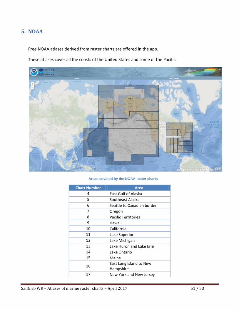
5. NOAA
Free NOAA atlases derived from raster charts are offered in the app.
These atlases cover all the coasts of the United States and some of the Pacific.
Areas covered by the NOAA raster charts
Chart Number Area
4 East Gulf of Alaska
5 Southeast Alaska
6 Seattle to Canadian border
7 Oregon
8 Pacific Territories
9 Hawaii
10 California
11 Lake Superior
12 Lake Michigan
13 Lake Huron and Lake Erie
14 Lake Ontario
15 Maine
16 East Long Island to New Hampshire
17 New York and New Jersey
SailGrib WR – Atlases of marine raster charts – April 2017 52 / 53
18 Delaware Maryland and Virginia
19 Carolinas
20 Northeast Florida and Georgia
21 Puerto Rico
22 South Florida
23 Northwest Florida Peninsula
24 New Orleans to Florida Panhandle
25 Louisiana
26 Texas
SailGrib WR – Atlases of marine raster charts – April 2017 53 / 53
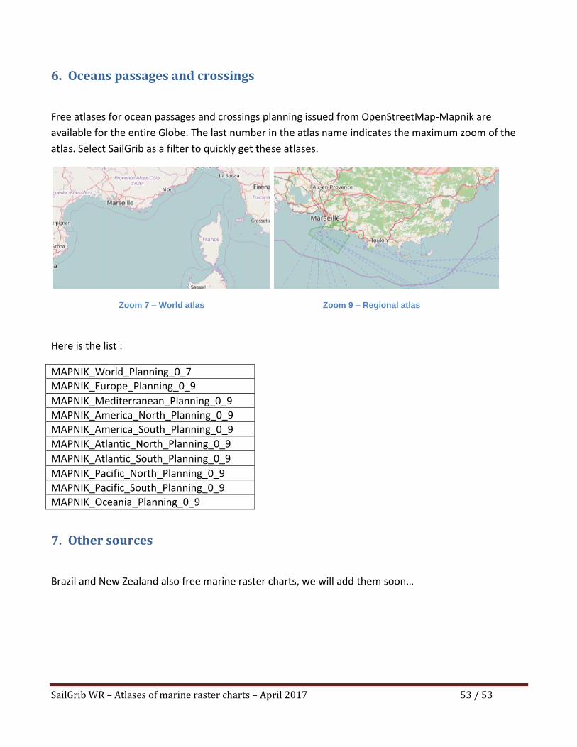
6. Oceans passages and crossings
Free atlases for ocean passages and crossings planning issued from OpenStreetMap-Mapnik are
available for the entire Globe. The last number in the atlas name indicates the maximum zoom of the
atlas. Select SailGrib as a filter to quickly get these atlases.
Zoom 7 – World atlas Zoom 9 – Regional atlas
Here is the list :
MAPNIK_World_Planning_0_7
MAPNIK_Europe_Planning_0_9
MAPNIK_Mediterranean_Planning_0_9
MAPNIK_America_North_Planning_0_9
MAPNIK_America_South_Planning_0_9
MAPNIK_Atlantic_North_Planning_0_9
MAPNIK_Atlantic_South_Planning_0_9
MAPNIK_Pacific_North_Planning_0_9
MAPNIK_Pacific_South_Planning_0_9
MAPNIK_Oceania_Planning_0_9
7. Other sources
Brazil and New Zealand also free marine raster charts, we will add them soon…