sa'ir town profile
TRANSCRIPT

Sa'ir Town Profile
Prepared by
The Applied Research Institute - Jerusalem
Funded by
Spanish Cooperation Azahar program
January 2008

Palestinian Localities Study Hebron Governorate
1
Table of Contents
Location and Physical Characteristics _________________________2 History___________________________________________________3 Religious and Archaeological Sites ____________________________3 Population________________________________________________4 Education ________________________________________________5 Health Status _____________________________________________7 Economic Activities ________________________________________7 Agricultural Sector _________________________________________9 Institutions and Services ___________________________________11 Infrastructure and Natural Resources_________________________11 Impact of the Israeli Occupation _____________________________12 Development Plans and Projects _____________________________12 Locality Development Priorities and Needs_____________________12 References_______________________________________________14

Palestinian Localities Study Hebron Governorate
2
Sa'ir Town Profile Location and Physical Characteristics Sa’ir is a town in Hebron Governorate located 8 km to the northeast of Hebron City in the southern part of the West Bank. It is bordered by the Dead Sea to the east, Beit Fajjar and Al Arroub camp to the north, Halhul to the west and Bani Na’im and Al Shuyukh to the south.
Map 1: Sa’ir town location and borders
Sa’ir town is located in a mountainous area at an elevation of 906 m above sea level. The mean annual rainfall in the town is 400 mm, the average annual temperature is 16° C, and the average annual humidity is 61% (ARIJ GIS). In 1997, the Palestinian Authority elected a Municipal Council to govern Sa’ir, which is currently comprised of 13 elected members with 31 employees. The council is run out of its own building, providing services to residents of Sa’ir, such as:

Palestinian Localities Study Hebron Governorate
3
1. Infrastructure services including water, electricity and solid waste disposal; 2. Issuing building licenses; and 3. Road construction and pavement.
History Sa'ir the town was established on the town of Saeer (صعير) or Saiour (صعيور), which means small (in Arabic: صغير). In the Roman era it was called Sior. Apparently, it is derived from the Aramaic word Sar which means rock or loftiness. (Ad Dabbagh, 1991) According to the Ministry of Local Authority, Sa’ir includes small localities like Al 'Uddeisa, Ras at Tawil, Ad Duwwara, Irqan Turad, Wadi ar Rim and Kuziba; in addition to Qla'a Zeta, Umm al Butum, Hamrush, and Beit 'Einun.
Photos of Sa’ir Town
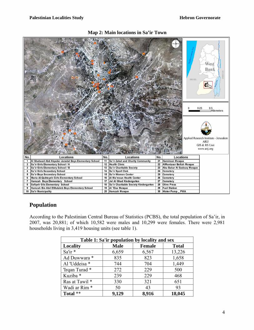
Religious and Archaeological Sites There are four mosques in Sa’ir town: 'Al’Eisa', 'Hamzah', 'AlMuntaser Bellah' and 'Hamiroun', as well as archaeological and historical sites, including the ruins of the ancient villages of 'Ein Sa’ir", 'Khirbet Kuziba', 'Khirbet Beit Einun' and 'Khirbet Abu Alduwayy'. Unfortunately, these sites are not well rehabilitated and are not used for touristic purposes. (See map 2)
Palestinian Localities Study Hebron Governorate
4
Map 2: Main locations in Sa’ir Town
Population According to the Palestinian Central Bureau of Statistics (PCBS), the total population of Sa’ir, in 2007, was 20,881; of which 10,582 were males and 10,299 were females. There were 2,981 households living in 3,419 housing units (see table 1).
Table 1: Sa'ir population by locality and sex Locality Male Female Total Sa'ir * 6,659 6,567 13,226 Ad Duwwara * 835 823 1,658 Al 'Uddeisa * 744 704 1,449 'Irqan Turad * 272 229 500 Kuziba * 239 229 468 Ras at Tawil * 330 321 651 Wadi ar Rim * 50 43 93 Total ** 9,129 8,916 18,045

Palestinian Localities Study Hebron Governorate
5
Beit 'Einun** 930 879 1,809 Qla’a Zeta ** 456 447 903 Umm al Butm ** 36 35 71 Hamrush ** 31 22 53 Grand Total 10,582 10,299 20,881
*Estimated numbers based upon the 1997 Census ** Source: PCBS 2008, Population, Housing and establishment, Census -2007, Final Results
Age groups and gender The 2007 census data listed the population of Sa’ir town by age group and sex. Data showed that 45.4% of the population were less than 15 years old, 51.3% were in the age group of 15-64 years and 2.9% were 65 year and above. In 2007, males constituted 50.6% of the population and females 49.4%, with a ratio of 102 males for every 100 females Families Sa'ir is hometown for many Palestinian families such as: Aِl Shlaldah, Al Froukh, Al Jaradat, Al Mtur, Al Jabareen, Al Kawazbeh, Al Turweh, and other families.
Education According to the 2007 Census, 8.6% of the residents were illiterate, with women comprising a higher percentage (70%) of the illiterate population than men. Of the literate population, 15.3% could read and write, 25.9% completed elementary education, 29.8% completed preparatory education and 13.9% completed their secondary education, while 6.8% completed their higher education. Table 2 shows the educational status in Sa’ir by sex and educational attainment in 2007.
Table 2: Sa’ir population (10 years and above) by sex and educational attainment Sex
Illiterate Can read & write Elementary Preparatory Secondary Associate
Diploma Bachelor Higher Diploma Master PhD Total
M 360 1,041 1,938 2,063 1,044 105 425 18 30 12 7,014 F 835 1,083 1,651 2,078 882 131 221 1 1 1 6,860 T 1,195 2,124 3,589 4,141 1,926 236 646 19 31 13 13,874
Source: PCBS, May 2009. Population, Housing and Establishment Census-2007, Final Results There are 17 governmental schools and one private school in Sa’ir, according to the field survey conducted by ARIJ in 2007, which provide elementary and secondary education. There are eight schools for males, eight schools for females and two co-educational schools. The number of schools by name, stage, sex and supervising authority is shown in table 3.

Palestinian Localities Study Hebron Governorate
6
Table 3: The schools in Sa’ir town, stage, sex and supervising authority No. School Name Stage Sex Supervising
Authority 1. Al Shaheed Abd Alqader Jaradat Boys Elementary
School / A Elementary Males Governmental
2. Al Shaheed Abd Alqader Jaradat Boys Elementary School / B
Elementary Males Governmental
3. Sa’ir Boys Elementary School Elementary Males Governmental 4. Sa’ir Boys Secondary School Secondary Males Governmental 5. Hamzah Bin Abd ElMutaleb Boys Elementary School Elementary Males Governmental 6. Kuziba Boys Elementary School Elementary Males Governmental 7. Ad Duwwara Boys Elementary School Elementary Males Governmental 8. Al 'Uddeisa Boys Elementary School Elementary Males Governmental 9. Maria Al-Qubteyeh Girls Elementary School Elementary Females Governmental
10. Sa’ir Girls Elementary School / A Elementary Females Governmental 11. Sa’ir Girls Elementary School / B Elementary Females Governmental 12. Sa’ir Girls Secondary School Secondary Females Governmental 13. Safiyeh Gils Elementary School Elementary Females Governmental 14. Kuziba Girls Secondary School Elementary Females Governmental 15. Ad Duwwara Girls Secondary School Elementary Females Governmental 16. Al 'Uddeisa Girls Secondary School Elementary Females Governmental 17. Jeel Al-Ghad Co-education School Elementary Co-Education Private 18. Wadi ar Rim Co-education School Elementary Co-Education Governmental
Ministry of Higher Education data shows that at the end of the 2006/2007 scholastic year there were 188 classes, 248 teachers and 5,461 Students in Sa’ir (See table 4).
Table 4: Total number of Schools, Classes and Students by Sex in Sa’ir town (2007) Gender Schools Class Teachers Students
Male 8 87 117 2,591 Female 8 92 120 2,760 Co-educational 2 9 11 110
Total 18 188 248 5,461 Source: Ministry of Higher Education –Hebron Directorate -2006/2007
In 2008, there were three kindergartens in Sa’ir town. Table 5 shows the number of kindergartens by name, number of children and supervising authority. Table 5: The kindergartens in Sa’ir town by name, number of classes, children, teachers and
supervising authority No. Kindergarten Name Number
of Classes Number of Children
Number of Teachers
Supervising Authority
1. Jel Al Ghad Kindergarten 3 96 5 Charitable 2. Sa’ir Charitable Society Kindergarten 3 65 3 Charitable 3. Al Ashbal Al Duwara Kindergarten 4 115 5 Private

Palestinian Localities Study Hebron Governorate
7
Education is underserved in Sa’ir, with a lack of a sufficient number of schools within the village boundaries to accommodate all students, forcing students to attend school in two shifts, morning and evening. Health Status Though the health sector in Sa’ir is considered well developed compared to surrounding localities and there are many private, governmental and charitable health facilities in the town (as shown in Table 6), there is only one ambulance to transport sick and injured people in emergency cases. Residents of Sa’ir have to travel to Hebron (10 km) or Bethlehem (25 km) to go to hospitals or other health centers, and this is considered one of the major problems facing the health sector in the area.
Table 6: Number of health institutions in Sa’ir town by supervising authority. Institution Governmental Private Charitable NGO Total Physician Clinic - 1 - - 1 Dental Clinic - 1 - - 1 Health Clinic (Al Ma’moun & Al Shifaa’) - 2 - - 2 X-Ray Centre - - - - - Medical Lab - 1 - - 1 Maternity & Pediatric Centre - - 1 - 1 Physiotherapy Centre - 1 - - 1 Pharmacy - 4 - - 4 Total - 10 1 - 11
Economic Activities According to Hebron localities' surveys conducted by ARIJ in 2008, Sa’ir's residents’ primary economic activity is within the Israeli labor market and the agricultural sector, with approximately 30% of the town labor force working within each sector. ARIJ survey indicated that the share of the population working in the various sectors of Sa’ir economy is listed below by percentage:
• Israeli labour market 30 %. • The agriculture sector 30 %. • The industry sector 12% • The trade sector 8 %. • The employee sector 17% • The service sector 3%.

Palestinian Localities Study Hebron Governorate
8
Figure 1: Percentage of economic activity in Sa’ir Town
Services3%
Agriculture30%
Industry12%
Trade & Commercial
8%
Employee17%
Israeli Labor Market30%
The most important industrial institutions in the town include 100 groceries, 30 clothing shops, 7 butchers, 8 blacksmith workshops, 6 carpentries and 50 service shops, in addition to several stone cutters in the town. Data indicates that the social groups in the town as a result of most affected by Israeli restrictions during the Second Intifada are: 1) Workers previously employed in the Israeli labor market, 2) Families maintaining six individuals or more, 3) Housekeeping and children , 4) Small-holder farmers, 5) Small-holder traders. Labour Force According to the 2007 PCBS, Population, Housing and Establishment Census, there were 4,202 economically active people in Sa’ir town, of whom 83.5% were employed, and 9,718 non economically active people, of whom 53.1% were students, 35.2% were housekeepers and 8.1% were unable to work (see Table 7).
Table 7: Sa’ir population (10 years and above) by sex and employment status Economically Active Non Economically Active S
ex Employed
Currently Unemployed
Unemployed (Never Worked)
Total Students House-keeping
Unable to work
Not working & Not looking For Work
Other Total Total
M 3,175 326 291 3,792 2,536 9 462 62 175 3,244 7,036 F 332 22 56 410 2,625 3,408 327 30 84 6,474 6,884 T 3,507 348 347 4,202 5,161 3,417 789 92 259 9,718 13,920
Source: PCBS, May 2009. Population, Housing and Establishment Census-2007, results

Palestinian Localities Study Hebron Governorate
9
Agricultural Sector Sa’ir town lies on a total area of 117,000 dunums; 45,000 dunums are considered arable land, however, only 11,715 dunums are cultivated. Another 33,285 dunums are agriculture lands as well, but are unutilized due to shortage of water, economic infeasibility and lack of investment capital. There are also 3,600 dunums of land in need of rehabilitation. (See table 8, and map 3) Table 8: Land Use in Sa’ir Town (dunum)
Arable Land Total Area Cultivated
Area Uncultivated
Area
Built up Area
Forests Area
Open Spaces and Rangelands
117,000 11,715 33,285 6,000 150 65,850 Source: Palestinian Ministry of Agricultural (MoA), 2006
Map 3: Land use/land cover and segregation wall in Sa’ir Town

Palestinian Localities Study Hebron Governorate
10
There are about 20 dunums of greenhouses but no tunnels in Sa’ir town. Of these, five dunums are used for growing tomatoes and fifteen dunums are used for growing cucumber. Table 9 shows the different types of rain-fed and irrigated open cultivated vegetables in Sa’ir. The irrigated fruity vegetables are the most cultivated covering an area of about 174 dunums.
Table 9: Total area of rain Fed and irrigated open cultivated vegetables in Sa’ir Town (dunum) Fruity
vegetables Leafy
vegetable Green
legumes Bulbs Other vegetables Total area
Rf Irr. Rf Irr. Rf Irr. Rf Irr. Rf Irr. Rf Irr. 25 66 22 46 9 12 0 30 8 20 64 174
Rf: Rain-fed, Irr: Irrigated There are two types of aromatic medical plants in the town of Sa’ir, thyme and sage, which spread over a total area of four dunums. In the town of Sa’ir, there is a 3,954 dunums planted with olive trees. Other trees planted in the area are mostly grape vines, apple and almond trees, fig trees and other stone fruits.
Table 10: Total area of horticulture and olive tree in Sa’ir Town (dunum) Olives Citrus Stone-fruits Pome fruits Nuts Other fruit Total area
Rf Irr Rf Irr Rf Irr Rf Irr Rf Irr Rf Irr Rf Irr 3,954 0 0 0 1930 0 89 0 154 0 3810 0 9,937 0
Rf: Rain-fed, Irr: Irrigated Table 11 shows the total area of field crops cultivated in the town of Sa’ir.
Table 11: Total area of field crops in Sa’ir Town (dunum)
Cereals Bulbs Dry legumes
Forage crops
Stimulatingcrops
Other crops Total area
Rf Irr Rf Irr Rf Irr Rf Irr Rf Irr Rf Irr Rf Irr 1,180 0 21 0 75 0 110 0 5 0 0 0 1391 0
Rf: Rain-fed, Irr: Irrigated The survey conducted by ARIJ indicated that about 10% of Sa’ir residents are also dependent upon rearing and keeping livestock, such as sheep, goats and chickens.
Table 12: Livestock in Sa’ir Town Cows* Sheep Goats Horses Donkeys Broilers Layers Bee Hives
- 5,000 3,200 - 75 200,000 7,000 270 *Including cows, bull calves, heifer calves and bulls Farmers of Sa’ir town are active, participating in agricultural societies and unions. There is one agricultural society in the town, the 'Extract of Grapes and Peaches Society' ( ة عصير العنب و جمعي .(البرقوق

Palestinian Localities Study Hebron Governorate
11
Rainwater is the main source of irrigation in Sa’ir town, but field survey data indicated that farmers also depend on water networks for irrigation. A six km road that is only suitable for driving vehicles is used in Sa'ir for agriculture purposes. Institutions and Services Sa’ir has many public institutions:
1. Sa’ir charitable society 2. Palestinian Red Crescent 3. Sa’ir Sport Club 4. Sa’ir Women Club 5. Sa’ir Zakat and Charity Community 6. Environmental Health Centre 7. The Extracts of Grapes and Peaches Society (جمعية عصير العنب و البرقوق)
Infrastructure and Natural Resources • Telecommunication Services: Approximately 60% of the housing units within the town
boundaries are connected to a telecommunication network. • Water Services: In 1976, Sa’ir connected to the water network and currently, nearly 90% of
housing units are connected to this Sa’ir Municipality administered network. Residents use springs and cisterns as alternative water resources, though the two springs in the town need rehabilitation to be used domestically. Furthermore, there is one water reservoir in Sa’ir with a 1000 cubic meter capacity. The main problems that face the water sector in the town include the existing old water network, which needs rehabilitation, and the continuous cutting and shortage of water especially in summertime. There are quit a few springs mainly in Kuiziba area that are used in agriculture; however, one is polluted.
• Electricity Services: Sa’ir town has been connected to the electricity network since 2000,
and approximately 95% of the housing units in the town are connected to the network. The Municipality of Sa’ir manages the distribution of electricity, which is supplied by the Israeli Electric Company (Al Qutriya). However, electricity services in the town are insufficient due to the old and deteriorated network, lack of enough generators, and the weak electrical current.
• Sewage Disposal Facilities: There is no sewage network in Sa’ir town. All households must
dispose of their wastewater in cesspits. • Solid Waste Collection: Sa’ir Municipality manages the collection of solid waste in the
town, owning garbage trucks that collect the solid waste from the residential areas and transport it to a special dumping site (Beer Abu Khurzah), located about 10 kilometers from the town. The solid wastes are usually burnt or buried in that site. According to municipal

Palestinian Localities Study Hebron Governorate
12
data, the amount of the solid waste generated daily in Sa’ir is estimated at 2 tons. Sa'ir also suffers from many environmental problems because of the sewage flow to the town's land from the surrounding settlements.
• Transportation Services: The town lacks a well-regulated public transportation system; all
public transportation vehicles used are unauthorized to carry passengers, and passengers primarily use private cars and taxis to reach their own destinations. Besides the informal transportation system, the town suffers from many other obstacles including checkpoints at the town entrances and poor roads conditions. There are about 193 km of roads in Sa’ir town; 28 km are paved and in a good condition, 43 km are paved yet not in a good condition and 122 km are not paved at all (See Table 13).
Table 13: The condition of roads and their length in Sa’ir Town
Road length (km) Road Condition Main roads Internal roads Agricultural roads Total Paved roads in good condition 16 12 - 28 Paved roads in bad condition 23 20 - 43 Unpaved roads 80 19 23 122
Total 119 51 23 193 Impact of the Israeli Occupation Sa’ir town is surrounded by two Israeli settlements, Asfar settlement ( أسفر), built on 1,500 dunums to the east, and Qiryat Arba’ settlement, built on 300 dunums to the west. In addition, one gate, several flying checkpoints and earth mound roadblocks restrict town residents. Israeli forces have also bulldozed and destroyed 500 dunums of town land, uprooting 300 olive trees, 200 grape vines and 300 almond trees.
Development Plans and Projects Since 2004, Sa’ir Municipality has implemented ten projects funded by various donors that serve the town's development plans.
Locality Development Priorities and Needs According to the municipality, the village is in need of many projects and plans for town development. Table 14 shows the development priorities and needs in the town.

Palestinian Localities Study Hebron Governorate
13
Table 14: Development Priorities and Needs in Sa’ir Town No. Sector Strongly
Needed Needed Moderately Needed
Not Needed Notes
Infrastructural Needs 1 Opening and Pavement of Roads * 70 km^ 2 Construction of New Water Networks * 20 km 3 Rehabilitation of Old Water Networks * 13km 4 Construction of Water Reservoirs * 2000 m3 5 Extending the Water Network to cover New
Built up Areas * 8 km
6 Construction of Sewage Disposal Network * Health Needs
1 Building of New Clinics or Health Care Centre
*
2 Rehabilitation of Old Clinics or Health Care Centres
*
3 Purchasing of Medical Equipments and Tools
*
Educational Needs 1 Building of New Schools * Secondary 2 Rehabilitation of Old Schools * Elementary 3 Purchasing of New Equipments for Schools *
Agricultural Needs 1 Rehabilitation of Agricultural lands * 3,000 dunums 2 Building Cisterns * 150 cisterns 3 Construction of Barracks for Livestock * 25 barracks 4 Veterinary Services * 5 Seeds and Hay for Animals * 6 Rehabilitation of Greenhouses * 15 greenhouses 7 Field Crops Seeds * 8 Plants and Agricultural Supplies *
^ 25 km main roads, 20 km link roads and 25 km agriculture roads

Palestinian Localities Study Hebron Governorate
14
References:
- Palestinian Central Bureau of Statistics. Population, Housing and Establishment Census- Final Results. Ramallah, Palestine. 1997 -2007.
- Ad Dabbagh, Mustafa. Palestine Our Homeland.: Kufr Qare', Palestine: Dar Al Huda Press, 1991. (In Arabic)
- Applied Research Institute – Jerusalem (ARIJ). GIS Database. 2006-2009. - Ministry of Agriculture. Agricultural Status Database in Hebron Governorate. 2006. - Ministry of Higher Education. Educational Status Database. 2006-2007.