samson brook catchment area water … · management peter coghlan senior engineer water corporation...
TRANSCRIPT
SAMSON BROOK CATCHMENT AREAWATER SOURCE PROTECTION PLAN
Waroona and Hamel Town Water SupplyIntegrated Water Supply System
WATER AND RIVERS COMMISSIONHYATT CENTRE3 PLAIN STREET
EAST PERTHWESTERN AUSTRALIA 6004
TELEPHONE (08) 9278 0300FACSIMILE (08) 9278 0301
WEBSITE: http://www.wrc.wa.gov.au
We welcome your feedbackA publication feedback form
can be found at the back of this publication,or online at http://www.wrc.wa.gov.au/public/feedback/
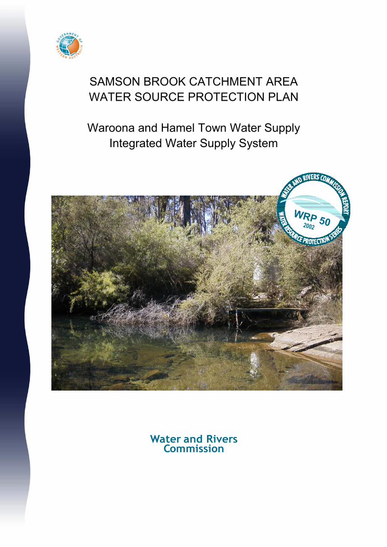
Cover Photograph: Gauging station downstream of Samson Brook dam [Taken by Ruth Harvey]

i
SAMSON BROOK CATCHMENT AREAWATER SOURCE PROTECTION PLAN
Waroona and Hamel Town Water Supplyand
Integrated Water Supply System
Prepared under the direction ofWater and Rivers Commission
Resource Management Divisionby the Infrastructure Planning Branch
of the Water Corporation
WATER AND RIVERS COMMISSION
WATER RESOURCE PROTECTION SERIES
WRP 502002
ii
AcknowledgmentsThis report was prepared by the Infrastructure Planning Branch of the Water Corporation under the guidance andsupervision of the Resource Quality Branch of the Water and Rivers Commission.
Contribution Personnel Title OrganisationProgram Direction Tony Laws Manager, Resource Quality Water and Rivers CommissionSupervision Stephen Watson Program Manager, Protection Planning Water and Rivers Commission
Kerry Laszig Senior Resource Protection Officer Water and Rivers CommissionManagement Peter Coghlan Senior Engineer Water CorporationReport preparation Ruth Harvey Engineer Water CorporationDrafting Susan Taylor Planning Information Officer Water Corporation
For more information contact:
Program Manager, Protection PlanningResource Quality BranchWater and Rivers Commission3 Plain StreetEAST PERTH WA 6004
Telephone: (08) 9278 0300Facsimile: (08) 9278 0585
Reference DetailsThe recommended reference for this publication is:Water and Rivers Commission 2002, Samson BrookCatchment Area Water Source Protection Plan:Waroona and Hamel Town Water Supply andIntegrated Water Supply Scheme, Water and RiversCommission, Water Resource Protection Series NoWRP 50.
ISSN 1326-7442ISBN 1-920687-01-7
Printed on recyclable stockDecember, 2002
iii
ForewordWater source protection plans
Water Source Protection Plans reflect the level ofprotection considered appropriate for specific drinkingwater sources (water reserves). They are developed inconsultation with affected landowners and industrygroups and relevant government agencies. They arealso released as a draft for further public commentbefore being finalised. The plans identify sources ofcontamination that should be investigated and set outprograms for management of the drinking waterresource.
Proclaiming Water Reserves and Catchment Areasunder the Metropolitan Water Supply Sewerage andDrainage Act 1909 and the Country Areas WaterSupply Act 1947 protects the quality of water sources inWestern Australia. The Acts’ by-laws enable theWater and Rivers Commission to control potentiallypolluting activities, to regulate land use, inspectpremises and to take steps to prevent or clean uppollution.
The Water and Rivers Commission aims to work pro-actively with planning agencies to incorporate waterprotection in the land planning process. This isbecause decisions on land use zoning and subdivisionapplications have a significant impact on the protectionof water sources given the wide range of land uses thatare assessed and may be approved. The Commissionsupports the amendment of Town Planning Schemesand Development Strategies that reflect land usecompatible with Water Source Protection Plans. AStatement of Planning Policy: Public Drinking WaterSource Policy is currently being prepared to further thisprocess.
This Water Source Protection Plan provides a basis forestablishing compatible land uses in the Samson BrookCatchment Area and is a mechanism for practicalimplementation of the Commission’s protectionstrategies. Local government decision-makers, Stateplanning authorities and operational staff areencouraged to recognise this document as a basis for
ensuring the long-term protection of this surface waterresource for generations to come.
Water quality protection framework
The Water and Rivers Commission is responsible formanaging and protecting Western Australia’s waterresources. This work is undertaken in accordance withthe State Water Quality Management Strategy (GWA,2001). The Commission has developed policies for theprotection of public drinking water source areas thatinclude three levels of priority classification.
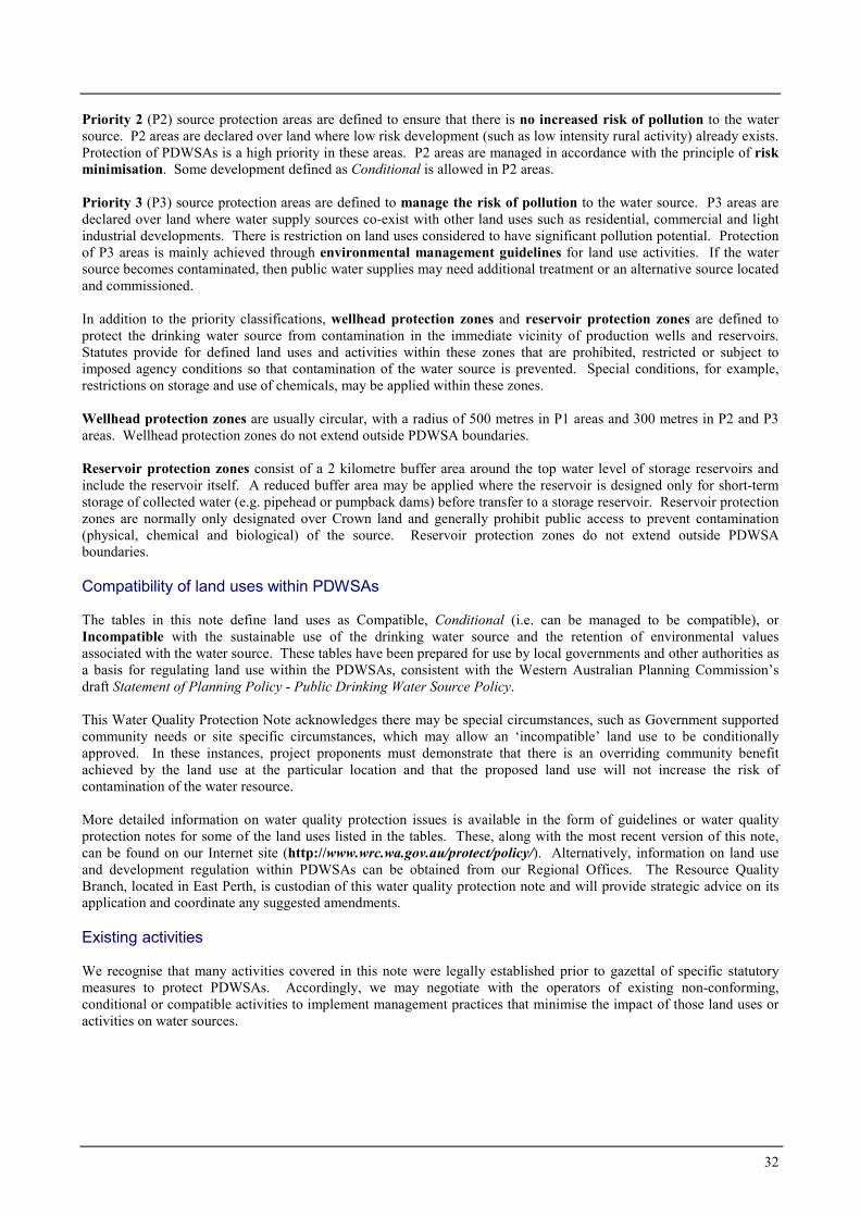
Priority 1 (P1) source protection areas are defined toensure that there is no degradation of the water source.P1 areas are declared over land where the provision ofthe highest quality public drinking water is the primebeneficial land use. P1 areas would typically includeland under Crown ownership. P1 areas are managed inaccordance with the principle of risk avoidance and soland development is generally not permitted.
Priority 2 (P2) source protection areas are defined toensure that there is no increased risk of pollution to thewater source. P2 areas are declared over land wherelow intensity development (such as rural) alreadyexists. Protection of public water supply sources is ahigh priority in these areas. P2 areas are managed inaccordance with the principle of risk minimisation andso conditional development is allowed.
Priority 3 (P3) source protection areas are defined tominimise the risk of pollution to the water source. P3areas are declared over land where water supplysources need to co-exist with other land uses such asresidential, commercial and light industrialdevelopments. Protection of P3 areas is achievedthrough management guidelines rather than restrictionson land use. If the water source does becomecontaminated, then water may need to be treated or analternative water source found.
In addition to priority classifications, reservoirprotection zones are defined to protect the water source

iv
from contamination in the immediate vicinity ofreservoirs. Reservoir protection zones usually consistof a 2 kilometre buffer area around the top water levelof a reservoir and include the reservoir itself. Thesezones do not extend outside the catchment area.Special restrictions apply in these zones.

v
ContentsSummary 21. Introduction 3
1.1 Existing water supply system 3
1.2 Existing water source protection 3
1.3 Future water supply system 3
1.4 Water resource allocation 3
2. Physiography 63. Climate 64. Hydrology 6
4.1 Water quality 6
4.2 Water treatment 7
5. Existing land use 95.1 Private land 9
5.2 Crown land 9
5.3 Recreation 9
6. Proclaimed areas and priorityclassification 126.1 Reservoir Protection Zone (RPZ) 12
7. Management of potential waterquality risks 127.1 Protection objectives 12
7.2 Best management practices 13
7.3 Land use planning 13
7.4 Emergency response 13
7.5 Land use, potential water quality risks
and recommended strategies 14
Recommendations 21Implementation strategy 22References 26Glossary 27Appendices 29
Appendix 1. Land Compatibility in Public DrinkingWater Source Areas 30
Appendix 2. The Samson RedevelopmentStakeholder Liaison Group 39
Appendix 3. Water Quality Monitoring 40
PhotographsPhotograph 1 - Existing Pipehead Weir 5
FiguresFigure 1. Samson Brook Catchment Locality
Plan 4Figure 2. Existing Samson Brook Catchment
Area 8Figure 3. Samson Brook Catchment Area –
Land Use and Tenure 11Figure 4. Proposed Samson Brook Catchment
Area and Priority Classifications 15
TablesTable 1. Land Use, Potential Water Quality
Risks and Recommended Strategies16

1
2
Summary
Samson Brook is about 100 km south of Perth. It isregulated by the Samson Brook Dam. The SamsonBrook Pipehead Weir, seven kilometres downstream ofthe main Dam, was constructed to provide Waroonaand Hamel with drinking water in 1962. The SamsonBrook forms part of the Waroona Irrigation District,which uses water from the Waroona, Drakes Brook andSamson Brook Dams.
It is proposed to redevelop the Samson Brook for theIntegrated Water Supply System. A new pipehead damwill be constructed upstream of the existing weir. Thiswill be connected to the Stirling Trunk Main and theWaroona and Hamel town supply.
The development of a source protection plan for thissource is consistent with the statewide program toprotect all public drinking water resources.
The microbiological water quality of this sourceexceeds levels that the World Health Organistion(WHO) drinking water guidelines considers can beadequately treated by disinfection alone. The healthrelated chemical water quality is good, althoughelevated turbidity is sometimes experienced.
The quality of the surface water resource is potentiallyat risk from activities in the catchment area. Land usein the catchment consists principally of State Forestunder a mining lease to Alcoa World AluminaAustralia (Alcoa). There is also recreation activity inthe catchment, most significantly fishing andmarroning. The Munda Biddi mountain bike trail hasbeen proposed to cross the Samson Brook at ScarpRoad. This water source protection plan reviews theexisting land uses and activities within the catchment,
and makes recommendations for protection of thewater source.
Currently the Samson Brook Pipehead Weir catchmentis gazetted under the Country Areas Water Supply Act1947. It is proposed that the catchment area beamended to reflect the location of the New PipeheadDam and for the area to be reproclaimed under theMetropolitan Water Supply Sewerage and DrainageAct 1909. Currently, the two Acts have different by-laws for protection of public drinking water sourceareas. However, the Commission is in the process ofreviewing both sets of by-laws, with the ultimateintention of promulgating consistent by-laws under thetwo Acts. The catchment area should be managed forPriority 1 source protection to preserve and protect thehigh quality of the water source.
Potential risks posed to the water quality of this sourcehave been carefully assessed recognising the detentiontime in the pipehead dam is likely to be only 2-3 days.Planned treatment for this supply is disinfection,fluoridation and buffering in the short term, althoughfiltration is being considered for implementation in thefuture.
The plan has undergone extensive consultation duringits development. A Stakeholder Liaison Group andcommunity open evenings provided key stakeholdersand members of the public with the opportunity to raiseissues for consideration and provide comments on theproposal.
The draft plan was released for public comment in May2002 and all submissions have been considered in thepreparation of this plan.
3
1. Introduction
The Samson Brook is located in the Harvey RiverBasin, approximately 100 km south of Perth and 5 kmsouth of Waroona. Its catchment area is within theShire of Waroona and managed by the Dwellingupoffice of the Department of Conservation and LandManagement (CALM).
Samson Brook Dam was completed in 1941. It is 31metres high and impounds a reservoir of 8 GL volumeand 104 ha surface area at a top water level of 245 mAHD. The estimated average annual streamflow intothe reservoir is 16.6 GL from a catchment area of 64km2. Samson Brook pipehead weir was constructed in1962 and supplies drinking water to the towns ofWaroona and Hamel. It is 1.3 m high and hasnegligible capacity. The contributing catchment belowthe dam is 10 km2.
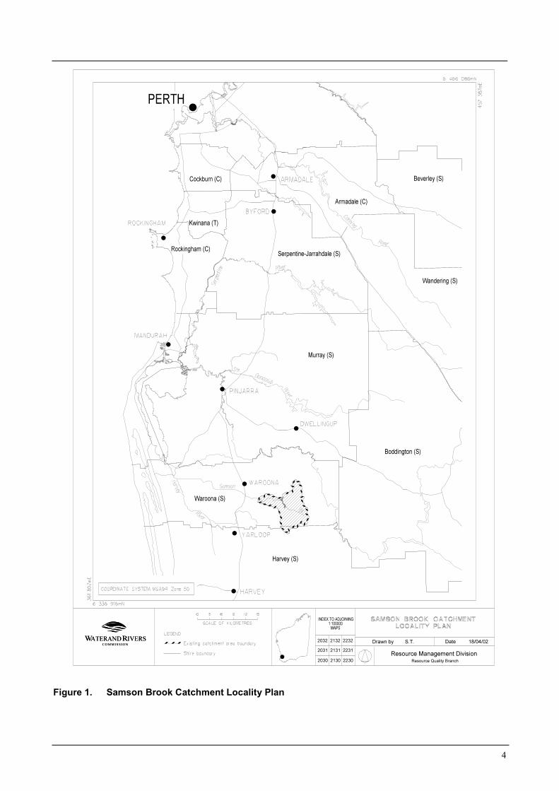
Figure 1 shows the location of the Samson Brook andits catchment area.
1.1 Existing water supply system
The Waroona Irrigation District uses water fromWaroona, Drakes Brook and Samson Brook Dams.For the last four years, combined irrigationconsumption has been around 10 GL per year, with5 GL taken from Samson and 5 GL from DrakesBrook/Waroona. The irrigation district is under thecontrol of Harvey Water (formerly South WestIrrigation Management Cooperative).
Samson Brook Dam, also known as Lake Kabbamup,regulates the upper reaches of Samson Brook. Water isreleased directly into the stream as required to supplythe irrigation scheme. The pipehead weir (Plate 1),7 km downstream from the dam, is used for theWaroona and Hamel town water supply.
1.2 Existing water source protection
The Samson Brook Catchment Area was originallyproclaimed in 1952 as the Waroona Water SupplyCatchment Area under the Country Areas Water SupplyAct 1947 to ensure protection of the water source from
potential contamination. In 2000 it was deproclaimedand simultaneously reproclaimed as the Samson BrookCatchment Area with slight modifications to theboundary. The Catchment Area was identified in thedraft Peel and Greater Bunbury Regional PlanningSchemes, where it is recognised as “proposed P1”,subject to the development of a Source Protection Plan.
1.3 Future water supply system
The proposed new scheme will consist of a newpipehead dam, which will replace the existing weir. Itwill have a nominal height of 20 m and a storagevolume of 300 ML. A 13 km trunk main will connectthis source to the Stirling Trunk Main. Waroona andHamel will also be serviced from the new pipeheaddam. Completion is planned for June 2003.
This Source Protection Plan is written for the currentand proposed future use of water from the SamsonBrook for public drinking water supply. Its objective isto propose strategies that will ensure land uses andactivities in the Samson Brook Catchment Area haveminimal impact on the water quality of this publicdrinking water source.
1.4 Water resource allocation
The Proposed Harvey Basin Surface Water AllocationPlan (WRC, 1998) defines surface water available foruse on an ecologically sustainable basis. There arecurrently three surface water allocation licences fromthe Harvey River, Drakes Brook and Samson Brooksources. They are issued to the Water Corporation,Alcoa World Alumina Australia and Harvey Water.Further allocations are subject to the establishment ofenvironmental water provisions.
1.4.1 Current Water Corporation allocationlicence
The applicable Surface Water Licence for the SamsonReservoir, Licence No. 0056289, applies to the HarveyRiver, Drakes Brook and Samson Brook. The totalallocation for abstraction from these sources for thepurpose of public water supply is 540 ML/year. Thislicence will change under the Samson BrookRedevelopment Scheme.
4
Figure 1. Samson Brook Catchment Locality Plan

5
Photograph 1 - Existing Pipehead Weir
6
2. Physiography
Samson Brook arises on the Darling Scarp, about100 km south of Perth. The Darling Scarp is the mostprominent physiographic feature of south-westernAustralia, rising steeply to 300 m above sea level. TheScarp is an ancient erosional feature, now lying 1-2 kmeast of the Darling Fault which separates the ArcheanYilgarn Block from the Phanerozoic sedimentarydeposits that underlie the Swan Coastal Plain to thewest.
Tributaries of the Harvey River, including SamsonBrook, have their headwaters in the northern jarrahforest, on the edge of the Great Plateau and ultimatelydrain into the Peel-Harvey estuarine system on thecoast. The Great Plateau is an area of ancient,weathered rock which results in the very low nutrientstatus of upland streams (Bunn and Davies, 1990). Incontrast, the nutrient concentration in the lowlandrivers is much greater, primarily due to clearing,cultivation and drain construction on the coastal plain.
3. Climate
The area has a Mediterranean-type climate,characterised by warm and dry summers with cool, wetwinters. The long-term average annual rainfall for thecatchment is approximately 1200 mm and most of thisfalls between May and September. Rainfall is seasonaland highly predictable. The annual averageevaporation is between 1200 and 1600 mm andmonthly evaporation ranges from 50 mm in June to 230mm in January.
Temperatures are warm to hot in summer and cool inwinter. Summer daily temperatures generally rangefrom 15-30 degrees C, whilst in winter the daily rangeis 5-15 degrees C.
Like all areas in the south-west, Waroona has receivedbelow average rainfall for the last 20 years. The effectof lower rainfall is amplified in streamflow. There hasbeen a statistically significant reduction in streamflowfor the period from 1975 to present (WRC, 1999). Adecline in annual rainfall of 10% has been shown to
reduce streamflow in jarrah catchments by about 30-40%.
Climate change from global warming has beenexamined by the Climate Impact Group in the CSIRODivision of Atmospheric Research (CSIRO, 2001).This group has developed climate change projections,which are continually updated. The latest projectionsfor the year 2030 for the south-west of WesternAustralia are:� Annual average warming of between 0.4 and 1.6
degrees C.� Rainfall change in the autumn, winter and spring
periods of –20% to +5% and rainfall change in thesummer period of –10% to +10%.
Interannual- and decade-scale climate variability willcontinue in the future and will remain a source ofuncertainty in projecting the impacts of future climatechange on resource yields.
4. Hydrology
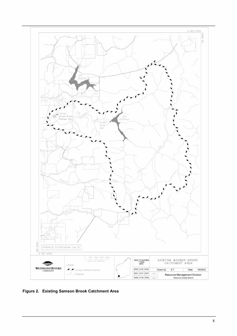
The combined catchment area for the existing SamsonBrook Dam and the existing Samson Pipehead Dam isshown in Figure 2.
The proposed pipehead dam will have a surface area of4 ha and a top water level of 130 m AHD. Thecatchment area for the Samson Brook Dam is 64 km2,and streamflow at this point averages 16.6 GL per year.There is a further 10 km2 of contributing catchment tothe pipehead dam, and streamflow at this pointaverages 21 GL per year. The average monthly naturalflow in the winter months is significantly greater thanin the summer months (PWD, 1984), although thispattern has been significantly altered by releases forirrigation requirements during summer.
Water inflow to the reservoir is mostly from surfacerunoff over the winter months. However, groundwaterseepage into the reservoir occurs from the lateriticgravels of the Darling Range.
4.1 Water quality
Water quality at the Samson Brook Dam and Samsonpipehead weir is regularly monitored for pH, turbidity,
7
colour, conductivity, iron, manganese and aluminium.Microbiological parameters are measured monthly at
the weir. Details of typical water quality monitoringresults are shown in Appendix 3.
The microbiological water quality of this sourceexceeds levels that the World Health Organistion(WHO) drinking water guidelines considers can beadequately treated by disinfection alone. The healthrelated chemical water quality is good, althoughelevated turbidity is sometimes experienced.
4.2 Water treatment
Current water treatment for the town water supplycomprises mechanical screening and disinfection.Treatment works will be refurbished as part of theredevelopment scheme.
Treatment in the short term for the integrated watersupply system will include disinfection, fluoridationand buffering (the latter for pH stabilisation to preventcorrosion of the Stirling Trunk Main).
Given that there are some risks to water quality in thecatchment and the need to provide water of assuredquality, it is likely that further treatment will berequired in the long term. This will be subject to theperformance of the system. Sand filtration will ensurethat turbidity levels are low and improve disinfectioneffectiveness. A comprehensive water qualitymonitoring program is in place for making decisionsregarding the staging of treatment works.
8
Figure 2. Existing Samson Brook Catchment Area
9
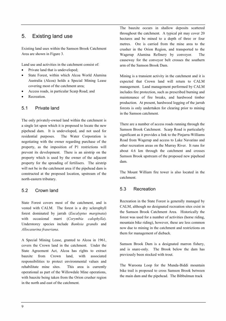
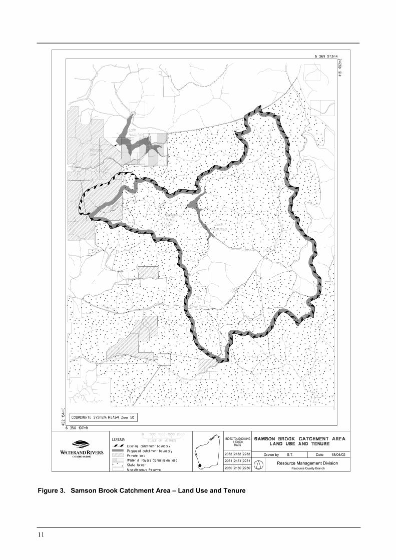
5. Existing land use
Existing land uses within the Samson Brook CatchmentArea are shown in Figure 3.
Land use and activities in the catchment consist of:� Private land that is undeveloped;� State Forest, within which Alcoa World Alumina
Australia (Alcoa) holds a Special Mining Leasecovering most of the catchment area;
� Access roads, in particular Scarp Road; and� Recreation.
5.1 Private land
The only privately-owned land within the catchment isa single lot upon which it is proposed to locate the newpipehead dam. It is undeveloped, and not used forresidential purposes. The Water Corporation isnegotiating with the owner regarding purchase of theproperty, as the imposition of P1 restrictions willprevent its development. There is an airstrip on theproperty which is used by the owner of the adjacentproperty for the spreading of fertilisers. The airstripwill not be in the catchment area if the pipehead dam isconstructed at the proposed location, upstream of thenorth-eastern tributary.
5.2 Crown land
State Forest covers most of the catchment, and isvested with CALM. The forest is a dry sclerophyllforest dominated by jarrah (Eucalyptus marginata)with occasional marri (Corymbia calophylla).Understorey species include Banksia grandis andAllocasurina fraseriana.
A Special Mining Lease, granted to Alcoa in 1961,covers the Crown land in the catchment. Under theState Agreement Act, Alcoa has rights to extractbauxite from Crown land, with associatedresponsibilities to protect environmental values andrehabilitate mine sites. This area is currentlyoperational as part of the Willowdale Mine operations,with bauxite being taken from the Orion crusher regionin the north and east of the catchment.
The bauxite occurs in shallow deposits scatteredthroughout the catchment. A typical pit may cover 20hectares and be mined to a depth of three or fourmetres. Ore is carried from the mine area to thecrusher in the Orion Region, and transported to theWagerup Alumina Refinery by conveyor. Thecauseway for the conveyor belt crosses the southernarm of the Samson Brook Dam.
Mining is a transient activity in the catchment and it isexpected that Crown land will return to CALMmanagement. Land management performed by CALMincludes fire protection, such as prescribed burning andmaintenance of fire breaks, and hardwood timberproduction. At present, hardwood logging of the jarrahforests is only undertaken for clearing prior to miningin the Samson catchment.
There are a number of access roads running through theSamson Brook Catchment. Scarp Road is particularlysignificant as it provides a link to the Pinjarra-WilliamsRoad from Wagerup and access to Lake Navarino andother recreation areas on the Murray River. It runs forabout 4.6 km through the catchment and crossesSamson Brook upstream of the proposed new pipeheaddam.
The Mount William fire tower is also located in thecatchment.
5.3 Recreation
Recreation in the State Forest is generally managed byCALM, although no designated recreation sites exist inthe Samson Brook Catchment Area. Historically theforest was used for a number of activities (horse riding,mountain bike riding), however, these are less commonnow due to mining in the catchment and restrictions onthem for management of dieback.
Samson Brook Dam is a designated marron fishery,and is snare-only. The Brook below the dam haspreviously been stocked with trout.
The Waroona Loop for the Munda-Biddi mountainbike trail is proposed to cross Samson Brook betweenthe main dam and the pipehead. The Bibbulmun track

10
passes outside the catchment to the east, and will not beimpacted by this source protection plan.
Tourism associated with recreation is important to thearea and forms a part of the valuable tourism industryin the south-west of the state.
11
Figure 3. Samson Brook Catchment Area – Land Use and Tenure
12
6. Proclaimed areas and priorityclassification
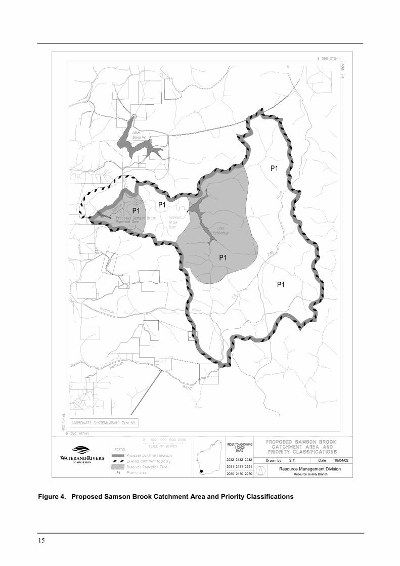
The Samson Brook catchment was originallyproclaimed under the Country Areas Water Supply Act1947 in 1952, as the Waroona Water SupplyCatchment Area. On 14 November 2000 thiscatchment area was deproclaimed and simultaneouslyreproclaimed as the Samson Brook Catchment Areawith slight modifications to the boundary. As theproposed pipehead dam will not be in the same locationas the existing water supply offtake, it is proposed thecatchment be reproclaimed to reflect this newboundary. The proposed Samson Brook CatchmentArea is shown in Figure 4.
It is proposed to manage the Samson Brook catchmentfor Priority 1 source protection. The objective is topreserve the high quality of this water by avoiding risksof contamination. This classification is justified on thefollowing basis:
� Samson Brook is the sole source for Waroona andHamel and will serve the Integrated Water SupplyScheme from 2003;
� The existing water quality is of a high standard;� Land is mostly in crown ownership;� Existing land uses are generally compatible with
P1 or can be managed according to P1 objectiveswith the use of best management practices;
� In the short term, the only treatment of water fromthe brook is proposed to be disinfection,fluoridation and buffering.
The detail of general land use compatibility for thePriority 1 source protection classification is listed inAppendix 1.
6.1 Reservoir Protection Zone (RPZ)
A reservoir protection zone is established to protectwater quality in the reservoir from immediate risks,including human contact. It is proposed that the areasurrounding the new pipehead dam and the SamsonBrook Dam be managed as a Reservoir ProtectionZone (RPZ). The RPZ is shown in Figure 4.
The RPZ is defined as an area within the gazettedcatchment approximately 2 km from the high waterlevel of the reservoir and includes the reservoir.
7. Management of potentialwater quality risks
The Priority 1 classification proposed for thiscatchment has the fundamental water quality objectiveof risk avoidance.
This plan generally recommends prohibition ofactivities involving human contact with the SamsonBrook, Samson Brook Dam, new pipehead dam andfeeder streams. Activities that require people to beclose to these water bodies will be discouraged andmanaged accordingly.
7.1 Protection objectives
There is a substantial potential risk to water qualityfrom possible pathogen contamination by human anddomestic animal contact with water. There are manypathogens that can contaminate water supplies; anumber of these are commonly known to contaminatewater supplies worldwide. These common pathogensinclude bacteria (e.g. Salmonella, Campylobacter, E.Coli. and Cholera), parasites (e.g. Cryptosporidium,Giardia) and viruses. These pathogens generally arisefrom faecal contamination.
The percentage of humans around the world who arecarriers of the various pathogens, and hence have thepotential to contaminate, ranges between 0.33%(Shigella) and 25% (Cholera El Tor in Asia) dependingon the pathogen in question (Geldreich, 1996). Forexample, it is estimated between 1-3.9% of people areinfected with Salmonella worldwide, 0.6-4.3% withCrytosporidium and 7.4% with Giardia. Estimates inAustralia for Giardia is as high as 20% for children inchild care (Grimmond et al., 1988).
Even if the lower limit were taken, as may be expectedin Australia, there is significant potential risk ofcontamination by any of these pathogens if humans,and hence human waste, are present in or near thereservoir and feeder streams.
13
This contamination has the potential to remain viablefor a significant amount of time in water. For example,Salmonella is viable for 2-3 months and Giardia foraround 1 month (Geldreich, 1996). Other referencesestimate viability for longer periods.
Based on the probability that a person near thereservoir is infected with one type of pathogen and theviable life of pathogens, human contact with the waterand the presence of humans near the reservoir or feederstreams is a risk to public water supply quality andhence human health. While disinfection effectivelykills many pathogens, it does not completely eliminateall pathogens. Preventing pathogen contamination inthe water source is the most effective way of removinga public health risk.
Samson Brook, together with Samson Brook Dam andthe proposed pipehead dam, is a strategic source forwater supply to Waroona, Hamel and the IntegratedWater Supply Scheme, supplying an estimated 300,000people. Hence potential risks posed to water qualityhave been carefully assessed. Based on the potentialrisk posed by human contact with the water and thenumber of people that could potentially be affected,activities that require contact with the water body areconsidered not acceptable in this catchment.
Activities that do not involve contact with the watergenerally pose less of a risk. Consequently, activitieswith no water contact are generally permitted, withmanagement conditions to ensure they do notcompromise water quality objectives.
This plan aims to balance water quality protection andsocial needs and aspirations as far as possible. Whereconstraints are required, it is proposed that affectedactivities are catered for in other more appropriatelocations.
The table in section 7.5 summarises the water qualityrisks associated with land uses and activities whichhave the potential to pose some risk to the quality ofthe water source. The table includes the reasoning forthe acceptability of this land use/activity andrecommends management and protection strategies.
7.2 Best management practices
Best Management Practices for land use activities areencouraged to help protect water quality.
Best Management Practices can be developed for anindividual enterprise or have a local or regional focusand must consider the full range of economic, socialand environmental issues associated with land, waterand vegetation use. Development of Best ManagementPractices must also take into consideration the needsand concerns of users, consumers and the widercommunity (ARMCANZ and ANZECC, 1996).
These are often in the form of an industry code ofpractice or environmental guideline. They are usuallydeveloped in consultation with industry groups,producers and State government agencies.
7.3 Land use planning
It is recognised that establishment of appropriateprotection mechanisms in statutory land use planningprocesses is necessary to secure the long-termprotection of water sources. It is therefore appropriatethat the Catchment Area and priority classification(s)be recognised in land planning strategies. SamsonBrook Catchment Area is recognised as “proposed P1”in both the Peel and Greater Bunbury RegionalPlanning Schemes.
7.4 Emergency response
Escape of chemicals during unforeseen incidents anduse of chemicals during emergency response can causestream and groundwater contamination. The LocalEmergency Management Advisory Committee throughthe Peel Emergency Management District should befamiliar with the location and purpose of the SamsonBrook Catchment Area. A locality plan should beprovided to the Fire and Rescue Services headquartersfor the HAZMAT Emergency Advisory Team. WaterCorporation should have an advisory role to anyHAZMAT incident in the Samson Brook CatchmentArea.

14
Personnel who deal with WESTPLAN - HAZMATincidents within the area should be given ready accessto a locality map of the Catchment Area. Thesepersonnel should receive training to ensure anunderstanding of the potential impacts of spills on thesurface water resource.
7.5 Land use, potential water qualityrisks and recommended strategies
The following table details the existing land uses in thecatchment, the potential water quality risks and leadsthrough a discussion to a recommended strategy tomanage the risk.
The discussion and recommended strategies balancethe need to protect water quality for the community inthe long-term, with the rights of land holders tocontinue to utilise land for lawful purposes.
15
Figure 4. Proposed Samson Brook Catchment Area and Priority Classifications
16
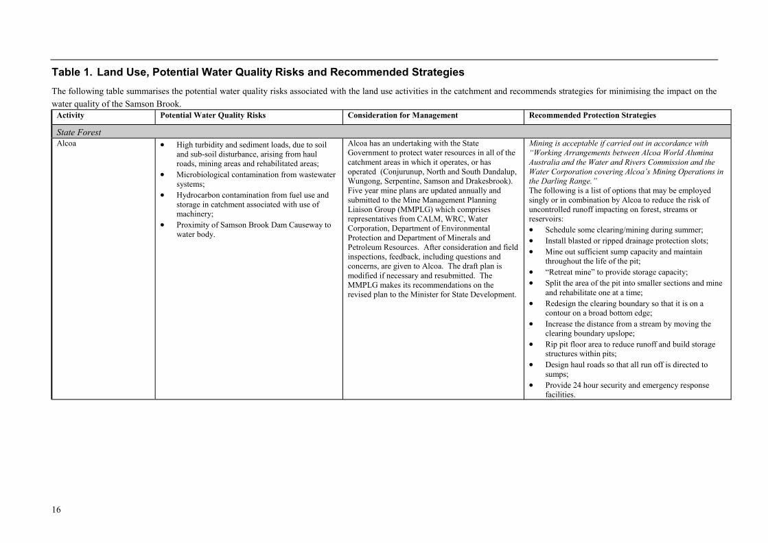
Table 1. Land Use, Potential Water Quality Risks and Recommended StrategiesThe following table summarises the potential water quality risks associated with the land use activities in the catchment and recommends strategies for minimising the impact on thewater quality of the Samson Brook.
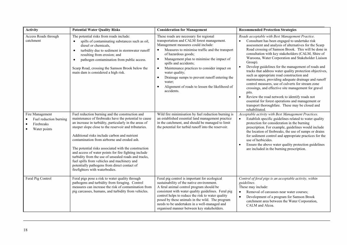
Activity Potential Water Quality Risks Consideration for Management Recommended Protection Strategies
State ForestAlcoa � High turbidity and sediment loads, due to soil
and sub-soil disturbance, arising from haulroads, mining areas and rehabilitated areas;
� Microbiological contamination from wastewatersystems;
� Hydrocarbon contamination from fuel use andstorage in catchment associated with use ofmachinery;
� Proximity of Samson Brook Dam Causeway towater body.
Alcoa has an undertaking with the StateGovernment to protect water resources in all of thecatchment areas in which it operates, or hasoperated (Conjurunup, North and South Dandalup,Wungong, Serpentine, Samson and Drakesbrook).Five year mine plans are updated annually andsubmitted to the Mine Management PlanningLiaison Group (MMPLG) which comprisesrepresentatives from CALM, WRC, WaterCorporation, Department of EnvironmentalProtection and Department of Minerals andPetroleum Resources. After consideration and fieldinspections, feedback, including questions andconcerns, are given to Alcoa. The draft plan ismodified if necessary and resubmitted. TheMMPLG makes its recommendations on therevised plan to the Minister for State Development.
Mining is acceptable if carried out in accordance with“Working Arrangements between Alcoa World AluminaAustralia and the Water and Rivers Commission and theWater Corporation covering Alcoa’s Mining Operations inthe Darling Range.”The following is a list of options that may be employedsingly or in combination by Alcoa to reduce the risk ofuncontrolled runoff impacting on forest, streams orreservoirs:� Schedule some clearing/mining during summer;� Install blasted or ripped drainage protection slots;� Mine out sufficient sump capacity and maintain
throughout the life of the pit;� “Retreat mine” to provide storage capacity;� Split the area of the pit into smaller sections and mine
and rehabilitate one at a time;� Redesign the clearing boundary so that it is on a
contour on a broad bottom edge;� Increase the distance from a stream by moving the
clearing boundary upslope;� Rip pit floor area to reduce runoff and build storage
structures within pits;� Design haul roads so that all run off is directed to
sumps;� Provide 24 hour security and emergency response
facilities.

17
Activity Potential Water Quality Risks Consideration for Management Recommended Protection Strategies
Hardwood Logging The risks associated with hardwood harvestinginclude:� turbidity due to log handling practices, and use
of unsealed roads and tracks;� fuel spills from vehicles and machinery;� pesticides from harvesting practices;� pathogens due to human presence including
from increased public access with roadupgrading
� spread of forest disease.
Currently, hardwood logging occurs in conjunctionwith Alcoa activities. Once the area has beenmined, it is likely that this will become the focus offorest management in the catchment.
The impact of hardwood harvesting on waterquality can be minimised through propermanagement. Water quality protection is arequirement of the CALM Act, which recognisesthe importance of water as a resource. Researchhas shown that timber harvesting does notnecessarily lead to increased turbidity in watercourses if proper harvesting management is in place(including vegetation buffers along water coursesand understorey vegetation left after timberharvesting) (Borg et al., 1988).
A further critical requirement to reduce turbidityfrom timber harvesting is the proper maintenanceof roads – particularly those required to carry heavylog transport vehicles.
Rehabilitation of roads and tracks following theharvesting process should be conducted to reducepublic access and erosion problems.
Baseline water quality data is frequently notavailable prior to harvesting, reducing the value ofpost-harvesting monitoring. The issues of who,when and how monitoring is conducted need to beaddressed, to aid informed management of forestryin the catchment.
Acceptable activity with Best Management Practices.� Undertake a review of the Manual of Management
Guidelines for Timber Harvesting and the Code ofPractice for Timber Harvesting to ensure waterquality protection objectives are addressed. Forexample, issues to be addressed would includeappropriate road construction and maintenance, use ofsumps or drains for sediment control, appropriateretention of buffer zones along watercourses, fuelstorage and handling and pesticide use.
� Ensure hardwood harvesting occurs in accordancewith the Code of Practice for Timber Harvesting.
� Ensure protocols are in place between relevantagencies on harvesting issues such as pesticide use androad routes and construction.
� Review detailed harvesting plans during the planningphase to ensure water quality protection objectives areincluded.
� Review the road network to identify roads notessential for forest operations and management ortransport thoroughfare.
� Close and rehabilitate tracks that are not required forforest operations and management or transportthoroughfare.
� Inspect water quality protection measures on site.
18
Activity Potential Water Quality Risks Consideration for Management Recommended Protection Strategies
Access Roads throughcatchment
The potential risks from roads include:� spills of contaminating substances such as oil,
diesel or chemicals,� turbidity due to sediment in stormwater runoff
resulting from erosion; and� pathogen contamination from public access.
Scarp Road, crossing the Samson Brook below themain dam is considered a high risk.
These roads are necessary for regionaltransportation and CALM forest management.Management measures could include:� Measures to minimise traffic and the transport
of hazardous goods;� Management plan to minimise the impact of
spills and accidents;� Maintenance practices to consider impact on
water quality;� Drainage sumps to prevent runoff entering the
water;� Alignment of roads to lessen the likelihood of
accidents.
Roads acceptable with Best Management Practice.� Consultant has been engaged to undertake risk
assessment and analysis of alternatives for the ScarpRoad crossing of Samson Brook. This will be done inconsultation with key stakeholders (CALM, Shire ofWaroona, Water Corporation and Stakeholder LiaisonGroup).
� Develop guidelines for the management of roads andtracks that address water quality protection objectives,such as appropriate road construction andmaintenance, providing adequate drainage and runoffcontrol measures, use of culverts for stream zonecrossings, and effective site management for gravelpits.
� Review the road network to identify roads notessential for forest operations and management ortransport thoroughfare. These may be closed andrehabilitated.
Fire Management� Fuel reduction burning� Firebreaks� Water points
Fuel reduction burning and the construction andmaintenance of firebreaks have the potential to causean increase in turbidity, particularly in the areas ofsteeper slope close to the reservoir and tributaries.
Additional risks include carbon and nutrientcontamination from airborne and eroded ash.
The potential risks associated with the constructionand access of water points for fire fighting includeturbidity from the use of unsealed roads and tracks,fuel spills from vehicles and machinery andpotentially pathogens from direct contact offirefighters with waterbodies.
Wild fire minimisation by fuel reduction burning isan established essential land management practicein the catchment, and should be managed to limitthe potential for turbid runoff into the reservoir.
Acceptable activity with Best Management Practices.� Establish specific guidelines related to water quality
protection for consideration in the burningprescription. For example, guidelines would includethe location of firebreaks, the use of sumps or drainsfor sediment control and appropriate practices for theuse of herbicides.
� Ensure the above water quality protection guidelinesare included in the burning prescription.
Feral Pig Control Feral pigs pose a risk to water quality throughpathogens and turbidity from foraging. Controlmeasures can increase the risk of contamination frompig carcasses, humans, and turbidity from vehicles.
Feral pig control is important for ecologicalsustainability of the native environment.A feral animal control program should beconsistent with water quality guidelines. Feral pigcontrol helps to reduce the risk to water qualityposed by these animals in the wild. The programneeds to be undertaken in a well-managed andorganised manner between key stakeholders.
Control of feral pigs is an acceptable activity, withinguidelines.These may include:� Removal of carcasses near water courses;� Development of a program for Samson Brook
catchment area between the Water Corporation,CALM and Alcoa.
19
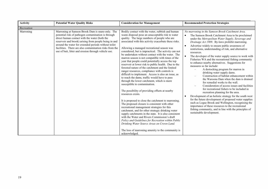
Activity Potential Water Quality Risks Consideration for Management Recommended Protection Strategies
RecreationMarroning Marroning at Samson Brook Dam is snare-only. The
potential risk of pathogen contamination is throughdirect human contact with the water (both thereservoir and brook) arising from people being in andaround the water for extended periods without toiletfacilities. There are also contamination risks from theuse of bait, litter and erosion through vehicle use.
Bodily contact with the water, rubbish and humanwaste disposal pose an unacceptable risk to waterquality. The large numbers of people who areassociated with this activity exacerbate these risks.
Allowing a managed recreational season wasconsidered, but is impractical. The activity can notbe undertaken without contact with the water. Themarron season is not compatible with times of theyear that people could potentially access the topreservoir at lower risk to public health. Due to theforested nature of the catchment and the limitedranger resources, compliance with controls isdifficult to implement. Access is also an issue, asto reach the dams, traffic would have to passthrough the lower catchment, which is moresusceptible to contamination.
The possibility of providing offsets at nearbyresources exists.
It is proposed to close the catchment to marroning.The proposed closure is consistent with otherrecreational management strategies for thiscatchment, and for other strategic drinking watersupply catchments in the state. It is also consistentwith the Water and Rivers Commission’s draftPolicy and Guidelines for Recreation within PublicDrinking Water Source Areas on Crown Land.
The loss of marroning amenity to the community isacknowledged.
No marroning in the Samson Brook Catchment Area.� The Samson Brook Catchment Area to be proclaimed
under the Metropolitan Water Supply, Sewerage andDrainage Act 1909. By-laws prohibit marroning.
� Advertise widely to ensure public awareness ofrestrictions, understanding of risk, and alternativeresources.
� The developer of the water supply source to work withFisheries WA and the recreational fishing communityto enhance nearby alternatives. Suggestions formeasures so far include:
– A destocking program for marron indrinking water supply dams.
– Construction of habitat enhancement withinthe Waroona Dam when the dam is drainedfor remedial works to the wall.
– Consideration of access issues and facilitiesfor recreational fishers to be included inrecreation planning for the area.
� Development of an holistic strategy for the south westfor the future development of proposed water suppliessuch as Logue Brook and Wellington, recognising theimportance of these resources to the recreationalfishing community, and in line with the principles ofsustainable development.
20
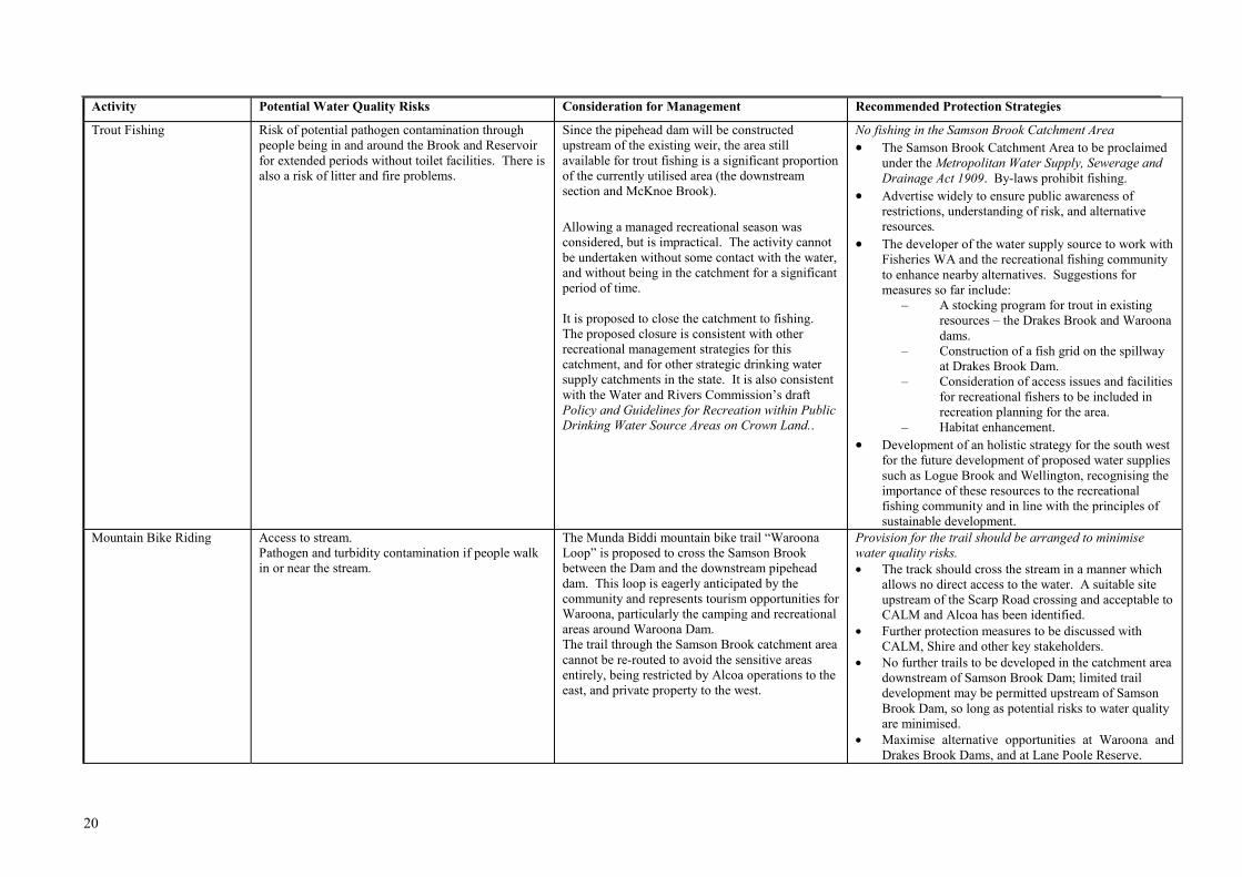
Activity Potential Water Quality Risks Consideration for Management Recommended Protection Strategies
Trout Fishing Risk of potential pathogen contamination throughpeople being in and around the Brook and Reservoirfor extended periods without toilet facilities. There isalso a risk of litter and fire problems.
Since the pipehead dam will be constructedupstream of the existing weir, the area stillavailable for trout fishing is a significant proportionof the currently utilised area (the downstreamsection and McKnoe Brook).
Allowing a managed recreational season wasconsidered, but is impractical. The activity cannotbe undertaken without some contact with the water,and without being in the catchment for a significantperiod of time.
It is proposed to close the catchment to fishing.The proposed closure is consistent with otherrecreational management strategies for thiscatchment, and for other strategic drinking watersupply catchments in the state. It is also consistentwith the Water and Rivers Commission’s draftPolicy and Guidelines for Recreation within PublicDrinking Water Source Areas on Crown Land..
No fishing in the Samson Brook Catchment Area� The Samson Brook Catchment Area to be proclaimed
under the Metropolitan Water Supply, Sewerage andDrainage Act 1909. By-laws prohibit fishing.
� Advertise widely to ensure public awareness ofrestrictions, understanding of risk, and alternativeresources.
� The developer of the water supply source to work withFisheries WA and the recreational fishing communityto enhance nearby alternatives. Suggestions formeasures so far include:
– A stocking program for trout in existingresources – the Drakes Brook and Waroonadams.
– Construction of a fish grid on the spillwayat Drakes Brook Dam.
– Consideration of access issues and facilitiesfor recreational fishers to be included inrecreation planning for the area.
– Habitat enhancement.� Development of an holistic strategy for the south west
for the future development of proposed water suppliessuch as Logue Brook and Wellington, recognising theimportance of these resources to the recreationalfishing community and in line with the principles ofsustainable development.
Mountain Bike Riding Access to stream.Pathogen and turbidity contamination if people walkin or near the stream.
The Munda Biddi mountain bike trail “WaroonaLoop” is proposed to cross the Samson Brookbetween the Dam and the downstream pipeheaddam. This loop is eagerly anticipated by thecommunity and represents tourism opportunities forWaroona, particularly the camping and recreationalareas around Waroona Dam.The trail through the Samson Brook catchment areacannot be re-routed to avoid the sensitive areasentirely, being restricted by Alcoa operations to theeast, and private property to the west.
Provision for the trail should be arranged to minimisewater quality risks.� The track should cross the stream in a manner which
allows no direct access to the water. A suitable siteupstream of the Scarp Road crossing and acceptable toCALM and Alcoa has been identified.
� Further protection measures to be discussed withCALM, Shire and other key stakeholders.
� No further trails to be developed in the catchment areadownstream of Samson Brook Dam; limited traildevelopment may be permitted upstream of SamsonBrook Dam, so long as potential risks to water qualityare minimised.
� Maximise alternative opportunities at Waroona andDrakes Brook Dams, and at Lane Poole Reserve.
21
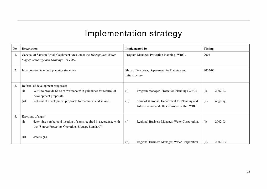
Recommendations1. The existing Samson Brook Catchment Area should be de-proclaimed and replaced by the proposed Samson Brook
Catchment Area (reflecting the new boundaries) under the Metropolitan Water Supply, Sewerage and Drainage Act1909.
2. Planning strategies should incorporate the management principles outlined in this plan and reflect the Priority 1classification assigned to the Catchment Area.
3. All development proposals in the Samson Brook Catchment Area which are likely to impact on water qualityshould be referred to the Water and Rivers Commission for consideration and advice.
4. Signs should be erected along the boundaries of the proposed Catchment Area to define the area and promotepublic awareness of the need to protect water quality.
5. Incidents covered by WESTPLAN – HAZMAT in the Samson Brook Catchment Area should be addressed throughthe following measures:
� The Local Emergency Management Advisory Committee (through the Peel Emergency Management District)being familiar with the location and purpose of the Samson Brook Catchment Area.
� The locality plan for the Samson Brook Catchment Area being provided to the Fire and Rescue Servicesheadquarters for the HAZMAT Emergency Advisory Team.
� The Water Corporation advising the HAZMAT Emergency Advisory Team during incidents in the Samson BrookCatchment Area.
� Personnel dealing with WESTPLAN – HAZMAT incidents in the area given ready access to a locality map of theCatchment Area and training to understand the potential impacts of spills on the surface water resource.
6. A surveillance program should be established to identify any incompatible land uses or potential contaminantthreats within the Catchment Area.
7. Review the surface water quality monitoring program to ensure key characteristic parameters are included.Routinely review water quality analysis results to detect any increasing trends.
8. The strategies detailed in Table 1 – Land use, potential water quality risks and recommended strategies should beadopted.
9. Implementation of these recommendations should be reviewed annually after this plan is endorsed. A full reviewof this protection plan should be undertaken after five years.
22
Implementation strategyNo Description Implemented by Timing
1. Gazettal of Samson Brook Catchment Area under the Metropolitan WaterSupply, Sewerage and Drainage Act 1909.
Program Manager, Protection Planning (WRC). 2003
2. Incorporation into land planning strategies. Shire of Waroona, Department for Planning andInfrastructure.
2002-03
3. Referral of development proposals:(i) WRC to provide Shire of Waroona with guidelines for referral of
development proposals.(ii) Referral of development proposals for comment and advice.
(i) Program Manager, Protection Planning (WRC).
(ii) Shire of Waroona, Department for Planning andInfrastructure and other divisions within WRC.
(i) 2002-03
(ii) ongoing
4. Erections of signs:(i) determine number and location of signs required in accordance with
the “Source Protection Operations Signage Standard”.
(ii) erect signs.
(i) Regional Business Manager, Water Corporation.
(ii) Regional Business Manager, Water Corporation
(i) 2002-03
(ii) 2002-03.
23
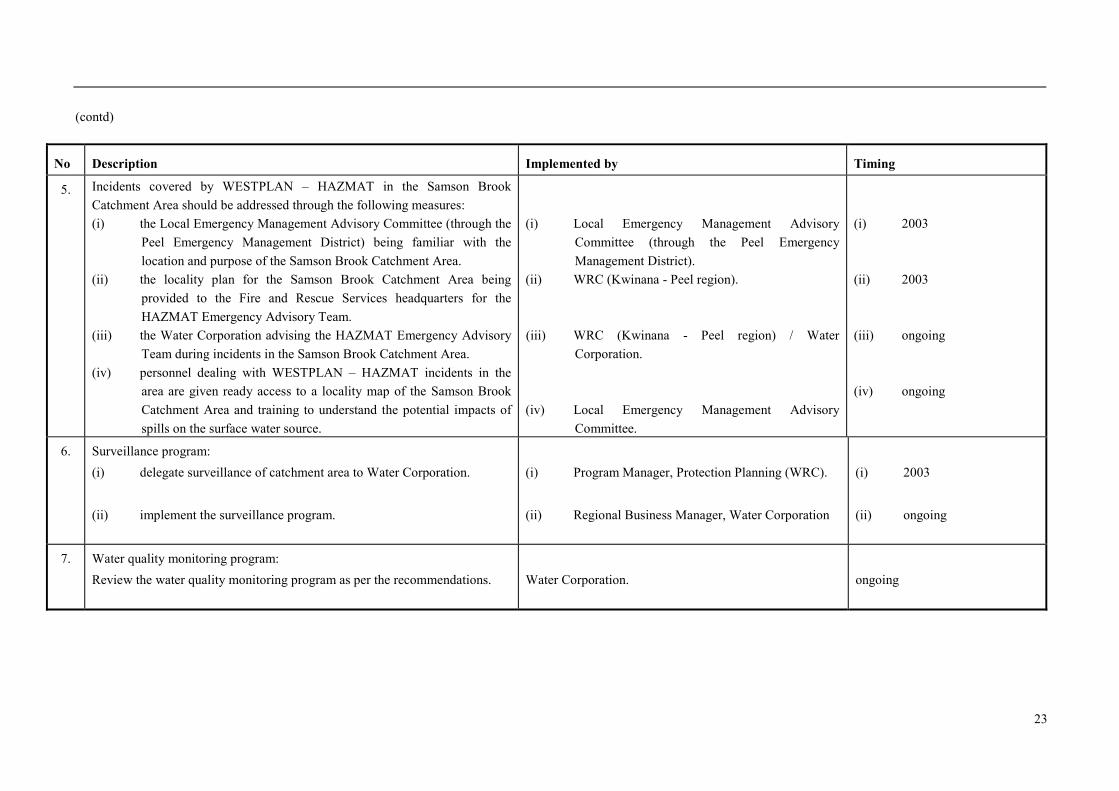
(contd)
No Description Implemented by Timing
5. Incidents covered by WESTPLAN – HAZMAT in the Samson BrookCatchment Area should be addressed through the following measures:(i) the Local Emergency Management Advisory Committee (through the
Peel Emergency Management District) being familiar with thelocation and purpose of the Samson Brook Catchment Area.
(ii) the locality plan for the Samson Brook Catchment Area beingprovided to the Fire and Rescue Services headquarters for theHAZMAT Emergency Advisory Team.
(iii) the Water Corporation advising the HAZMAT Emergency AdvisoryTeam during incidents in the Samson Brook Catchment Area.
(iv) personnel dealing with WESTPLAN – HAZMAT incidents in thearea are given ready access to a locality map of the Samson BrookCatchment Area and training to understand the potential impacts ofspills on the surface water source.
(i) Local Emergency Management AdvisoryCommittee (through the Peel EmergencyManagement District).
(ii) WRC (Kwinana - Peel region).
(iii) WRC (Kwinana - Peel region) / WaterCorporation.
(iv) Local Emergency Management AdvisoryCommittee.
(i) 2003
(ii) 2003
(iii) ongoing
(iv) ongoing
6. Surveillance program:(i) delegate surveillance of catchment area to Water Corporation.
(ii) implement the surveillance program.
(i) Program Manager, Protection Planning (WRC).
(ii) Regional Business Manager, Water Corporation
(i) 2003
(ii) ongoing
7. Water quality monitoring program:Review the water quality monitoring program as per the recommendations. Water Corporation. ongoing
24
(contd)
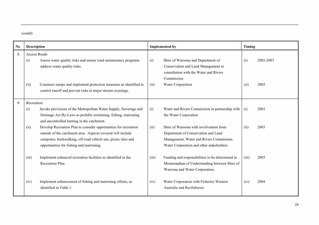
No Description Implemented by Timing
8. Access Roads(i) Assess water quality risks and ensure road maintenance programs
address water quality risks.
(ii) Construct sumps and implement protection measures as identified tocontrol runoff and prevent risks at major stream crossings.
(i) Shire of Waroona and Department ofConservation and Land Management inconsultation with the Water and RiversCommission.
(ii) Water Corporation
(i) 2002-2003
(ii) 2003
9. Recreation(i) Invoke provisions of the Metropolitan Water Supply, Sewerage and
Drainage Act By-Laws to prohibit swimming, fishing, marroningand uncontrolled hunting in the catchment.
(ii) Develop Recreation Plan to consider opportunities for recreationoutside of the catchment area. Aspects covered will includecampsites, bushwalking, off-road vehicle use, picnic sites andopportunities for fishing and marroning.
(iii) Implement enhanced recreation facilities as identified in theRecreation Plan.
(iv) Implement enhancement of fishing and marroning offsets, asidentified in Table 1.
(i) Water and Rivers Commission in partnership withthe Water Corporation
(ii) Shire of Waroona with involvement fromDepartment of Conservation and LandManagement, Water and Rivers Commission,Water Corporation and other stakeholders.
(iii) Funding and responsibilities to be determined inMemorandum of Understanding between Shire ofWaroona and Water Corporation.
(iv) Water Corporation with Fisheries WesternAustralia and Recfishwest.
(i) 2003
(ii) 2003
(iii) 2003
(iv) 2004
25
(contd)
No Description Implemented by Timing
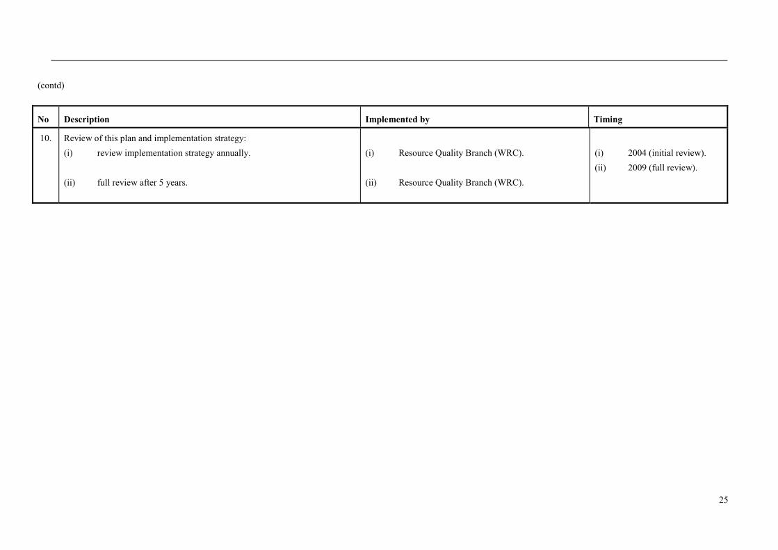
10. Review of this plan and implementation strategy:(i) review implementation strategy annually.
(ii) full review after 5 years.
(i) Resource Quality Branch (WRC).
(ii) Resource Quality Branch (WRC).
(i) 2004 (initial review).(ii) 2009 (full review).
26
ReferencesAgriculture and Resource Management Council of
Australia and New Zealand and Australian andNew Zealand Environment and ConservationCouncil, 1996, Draft Rural Land Uses and WaterQuality A Community Resource Document,ARMCANZ and ANZECC, 1996.
Borg, H., Loh I. C. and Bell R. W., 1988, The effect oflogging stream buffers on stream sedimentconcentration and turbidity - Results from theSouthern Forest of Western Australia, Report No.23, Water Authority of Western Australia, July1988.
Bunn, S.E and Davies P.M., 1990, Why is the streamfauna of south-western Australia so impoverished?Hydrobiologia, 1990-04-17, 194 (2), p69-176.
CSIRO, 2001, Climate Change Projections forAustralia, CSIRO Atmospheric Research, Victoria,2001
Geldreich, E.E., 1996, Pathogenic Agents inFreshwater Resources, Hydrological Processes,Volume 10, pp 315-333, 1996.
Grimmond, T.R., Radford A.J. and Brownridge T.,1988, Giardia carriage in aboriginal and non-
aboriginal children attending urban day-carecentres in South Australia, Australian PaediatricJournal, Volume 24, pp 304-305, 1988.
Government of Western Australia, 2001, State WaterQuality Management Strategy No. 1 Framework forImplementation, GWA, 2001.
National Health and Medical Research Council andAgriculture and Resource Management Council ofAustralia and New Zealand, 1996, AustralianDrinking Water Guidelines, NH&MRC andARMCANZ, 1996.
PWD, 1984, Streamflow Records of Western Australiato 1982 - Volume 2 - Basins 613-617, WaterResources Branch of the Public Works Department,WA, 1984.
WRC, 1999, The Effect of Climate Variability onStreamflow in the South-west of Western Australia,Water and Rivers Commission Report SWH 25(unpublished), Water and Rivers Commission,1999.
27
GlossaryAllocation The quantity of water permitted to be abstracted by an allocation licence, usually
specified in kilolitres/year (kL/a).
Alluvium (alluvial) Detrital material which is transported by streams and rivers and deposited.
Catchment The area of land which intercepts rainfall and contributes the collected water tosurface water (streams, rivers, wetlands) or groundwater.
Diffuse Source Pollution Pollution originating from a widespread area e.g. urban stormwater runoff,agricultural runoff.
Effluent The liquid, solid or gaseous wastes discharged by a process, treated or untreated.
Leaching / Leachate The process by which materials such as organic matter and mineral salts are washedout of a layer of soil or dumped material by being dissolved or suspended inpercolating rainwater, the material washed out is known as leachate. Leachate canpollute groundwater and waterways.
m AHD Australian Height Datum. Height in metres above Mean Sea Level +0.026 m atFremantle.
Nutrient Load The amount of nutrient reaching the waterway over a given time (usually per year)from its catchment area.
Nutrients Minerals dissolved in water, particularly inorganic compounds of nitrogen (nitrateand ammonia) and phosphorus (phosphate) which provide nutrition (food) for plantgrowth. Total nutrient levels include the inorganic forms of an element plus anybound in organic molecules.
Pesticides Collective name for a variety of insecticides, fungicides, herbicides, algicides,fumigants and rodenticides used to kill organisms.
Point Source Pollution Specific localised source of pollution e.g. sewage or effluent discharge, industrialwaste discharge.
Pollution Water pollution occurs when waste products or other substances e.g. effluent, litter,refuse, sewage or contaminated runoff, change the physical, chemical, biological orthermal properties of the water, adversely affecting water quality, living species andbeneficial uses.
Runoff Water that flows over the surface from a catchment area, including streams.
Scheme Supply Water diverted from a source (or sources) by a water authority or private companyand supplied via a distribution network to customers for urban, industrial orirrigation use.

28
Storage Reservoir A major reservoir of water created in a river valley by building a dam.
Stormwater Rainwater which has run off the ground surface, roads, paved areas etc and isusually carried away by drains.
Treatment Application of techniques such as settlement, filtration and chlorination to renderwater suitable for specific purposes including drinking and discharge to theenvironment.
Wastewater Water that has been used for some purpose and would normally be treated anddiscarded. Wastewater usually contains significant quantities of pollutant.
Water Quality The physical, chemical and biological measures of water.

29
AppendicesAppendix 1. Land use compatibility in Public Drinking Water Source AreasAppendix 2. Samson Brook Redevelopment Stakeholder Liaison GroupAppendix 3. Water Quality Monitoring

30
Appendix 1. Land Compatibility in Public DrinkingWater Source Areas
31
Land Use Compatibility in Public Drinking WaterSource AreasPurpose
This water quality protection note provides our position on land use practices and activities within areas gazetted aspublic drinking water sources, for protection and maintenance of the quality of the State’s drinking water resources.
This note forms an integral part of the Western Australian Planning Commission’s draft Statement of Planning Policy -Public Drinking Water Source Policy prepared by the Department for Planning and Infrastructure under Section 5AA ofthe Town Planning and Development Act 1928. The note will be reviewed in March and September each year andupdated to reflect our present policy position, advances in technology or land use activity standards and decisions madeconcerning drinking water quality protection.
The note should be used when developing formal guidelines on land use activities in public drinking water source areasin consultation with key stakeholders, such as the Department for Planning and Infrastructure, local government and theDepartment of Agriculture.
Scope
The note provides our position on a range of land uses assessed against our water quality protection strategies andmanagement objectives within Public Drinking Water Source Areas (PDWSAs). Where a specific land use has notbeen covered in the accompanying tables, it should be referred to our Resource Quality Branch for assessment and awritten response.
PDWSAs are Underground Water Pollution Control Areas, Water Reserves or Catchment Areas declared under theMetropolitan Water Supply, Sewerage and Drainage Act 1909 or Country Areas Water Supply Act 1947.
The note is intended to complement the statutory role and policy of other State and local government authorities. Thenote does not override the need for proponents to fulfil their legal responsibilities, including land use planning,environmental, health and building approvals.
PDWSA Protection Framework
This agency is responsible for managing and protecting the State’s water resources. Our policy for the protection ofpublic drinking water source areas includes three risk management-based priority zones for land within PDWSAs.Priority classifications are determined through specific Water Source Protection Plans, that are prepared in consultationwith State government agencies, landowners, local government, and key industry and community stakeholders.
Priority 1 (P1) source protection areas are defined and managed to ensure that there is no degradation of the watersource in these areas. This is the highest level of protection for the water sources and normally will apply to landowned or managed by State agencies. P1 areas are characterised by low-intensity and low-risk land uses, such asforestry and extractive industries. Protection of the public drinking water source outweighs virtually all other land uses.P1 areas are managed using the principle of risk avoidance. Most land uses are incompatible with P1 managementobjectives.
OCTOBER 2002
32
Priority 2 (P2) source protection areas are defined to ensure that there is no increased risk of pollution to the watersource. P2 areas are declared over land where low risk development (such as low intensity rural activity) already exists.Protection of PDWSAs is a high priority in these areas. P2 areas are managed in accordance with the principle of riskminimisation. Some development defined as Conditional is allowed in P2 areas.
Priority 3 (P3) source protection areas are defined to manage the risk of pollution to the water source. P3 areas aredeclared over land where water supply sources co-exist with other land uses such as residential, commercial and lightindustrial developments. There is restriction on land uses considered to have significant pollution potential. Protectionof P3 areas is mainly achieved through environmental management guidelines for land use activities. If the watersource becomes contaminated, then public water supplies may need additional treatment or an alternative source locatedand commissioned.
In addition to the priority classifications, wellhead protection zones and reservoir protection zones are defined toprotect the drinking water source from contamination in the immediate vicinity of production wells and reservoirs.Statutes provide for defined land uses and activities within these zones that are prohibited, restricted or subject toimposed agency conditions so that contamination of the water source is prevented. Special conditions, for example,restrictions on storage and use of chemicals, may be applied within these zones.
Wellhead protection zones are usually circular, with a radius of 500 metres in P1 areas and 300 metres in P2 and P3areas. Wellhead protection zones do not extend outside PDWSA boundaries.
Reservoir protection zones consist of a 2 kilometre buffer area around the top water level of storage reservoirs andinclude the reservoir itself. A reduced buffer area may be applied where the reservoir is designed only for short-termstorage of collected water (e.g. pipehead or pumpback dams) before transfer to a storage reservoir. Reservoir protectionzones are normally only designated over Crown land and generally prohibit public access to prevent contamination(physical, chemical and biological) of the source. Reservoir protection zones do not extend outside PDWSAboundaries.
Compatibility of land uses within PDWSAs
The tables in this note define land uses as Compatible, Conditional (i.e. can be managed to be compatible), orIncompatible with the sustainable use of the drinking water source and the retention of environmental valuesassociated with the water source. These tables have been prepared for use by local governments and other authorities asa basis for regulating land use within the PDWSAs, consistent with the Western Australian Planning Commission’sdraft Statement of Planning Policy - Public Drinking Water Source Policy.
This Water Quality Protection Note acknowledges there may be special circumstances, such as Government supportedcommunity needs or site specific circumstances, which may allow an ‘incompatible’ land use to be conditionallyapproved. In these instances, project proponents must demonstrate that there is an overriding community benefitachieved by the land use at the particular location and that the proposed land use will not increase the risk ofcontamination of the water resource.
More detailed information on water quality protection issues is available in the form of guidelines or water qualityprotection notes for some of the land uses listed in the tables. These, along with the most recent version of this note,can be found on our Internet site (http://www.wrc.wa.gov.au/protect/policy/). Alternatively, information on land useand development regulation within PDWSAs can be obtained from our Regional Offices. The Resource QualityBranch, located in East Perth, is custodian of this water quality protection note and will provide strategic advice on itsapplication and coordinate any suggested amendments.
Existing activities
We recognise that many activities covered in this note were legally established prior to gazettal of specific statutorymeasures to protect PDWSAs. Accordingly, we may negotiate with the operators of existing non-conforming,conditional or compatible activities to implement management practices that minimise the impact of those land uses oractivities on water sources.

33
Proposed activities
Following consideration of this protection note, please consult our nearest Regional Office for advice on the location ofPublic Drinking Water Source Areas, Priority areas and protected zones, and aspects of the land use proposal that mayaffect water resources. All statutory State and local government planning policies, scheme provisions, and the normalplanning approval processes apply and are not over-ridden by this note.
Definition of terms used in the following tables
"Compatible" means the land use is compatible with the management objectives of the priority classification.
"Conditional" means the land use can be compatible with the management objectives of the priority classification,provided appropriate site management practices are used. Conditional developments or activities should be referred tothis agency for assessment and a written response.
"Incompatible" means the land use is incompatible with the management objectives of the priority classification. Wewill normally oppose their approval by regulators. Any contentious development proposals received may be referredfor formal Environmental Impact Assessment via the Environmental Protection Act 1986.
“Extensive” means limited additional inputs are required to support the desired land use, e.g. supplementary animalfeed only during seasonal dry periods or during the final preparation of stock for the market.
“Intensive” means regular additional inputs are required to support the desired land use, e.g. irrigation, fertilisers, ornon-forage animal feed dominates.
Interpretation of land use recommendations into planning schemes and decisions
When translating the recommendations of the land use compatibility table into planning schemes and decisions, thefollowing relationships should be used:
a) Where the table identifies a land use as “Compatible”, this use is permitted within that priority source protectionarea. It should be identified as a "P" (permitted) use in a scheme, providing the use complies with the relevantdevelopment standards and the requirements of the scheme.
b) Where the table identifies a use as “Conditional”, this land use is considered to be a discretionary use within thepriority source protection area and should be identified as either a "D" or "A” (after special notice) use in thescheme. Proposals for Conditional uses should be referred to this agency for assessment and response, unless prioragreement has been made between a specific local government authority and this agency on regulatory measures.Specific guidelines, codes of practice or notes covering a land-use type, or memoranda of understanding may beused to define an agreed position on the land-use type or activity.
c) Where the table identifies a use as “Incompatible”, this use should not be permitted within that priority sourceprotection area, and should be identified as an "X" (not acceptable) use in the scheme.
d) Where the table does not include a proposed land use, that use should be considered to be “Incompatible” until theproject proponent can demonstrate that it meets the drinking water quality protection objective for the Priority areawithin the PDWSA.
If the land use planning approval process supports a proposal that is inconsistent with our drinking water qualityprotection advice for the priority source protection area, then we should be advised of this situation and the reasons forthat decision. This advice will trigger an assessment of the significance of that decision to the drinking water sourceand will be considered in the periodic review of this water quality protection note.
34
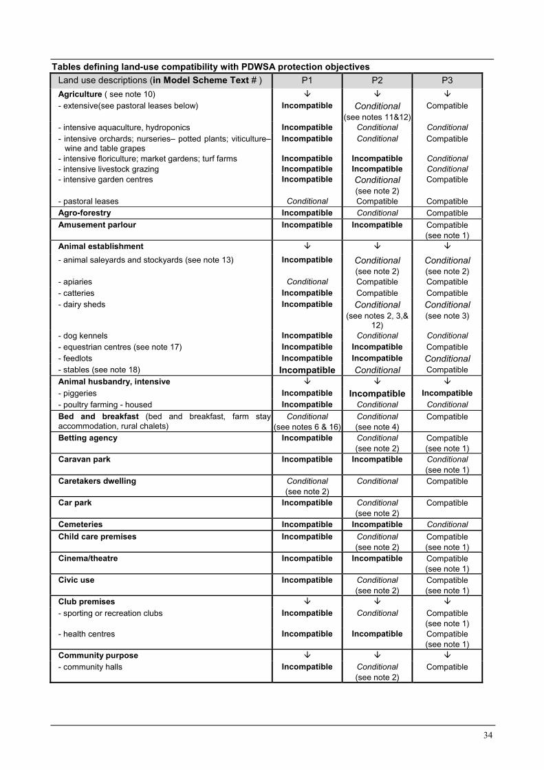
Tables defining land-use compatibility with PDWSA protection objectivesLand use descriptions (in Model Scheme Text # ) P1 P2 P3Agriculture ( see note 10) � � �
- extensive(see pastoral leases below) Incompatible Conditional(see notes 11&12)
Compatible
- intensive aquaculture, hydroponics Incompatible Conditional Conditional- intensive orchards; nurseries– potted plants; viticulture–
wine and table grapesIncompatible Conditional Compatible
- intensive floriculture; market gardens; turf farms Incompatible Incompatible Conditional- intensive livestock grazing Incompatible Incompatible Conditional- intensive garden centres Incompatible Conditional
(see note 2)Compatible
- pastoral leases Conditional Compatible CompatibleAgro-forestry Incompatible Conditional CompatibleAmusement parlour Incompatible Incompatible Compatible
(see note 1)Animal establishment � � �
- animal saleyards and stockyards (see note 13) Incompatible Conditional(see note 2)
Conditional(see note 2)
- apiaries Conditional Compatible Compatible- catteries Incompatible Compatible Compatible- dairy sheds Incompatible Conditional
(see notes 2, 3,&12)
Conditional(see note 3)
- dog kennels Incompatible Conditional Conditional- equestrian centres (see note 17) Incompatible Incompatible Compatible- feedlots Incompatible Incompatible Conditional- stables (see note 18) Incompatible Conditional CompatibleAnimal husbandry, intensive � � �
- piggeries Incompatible Incompatible Incompatible- poultry farming - housed Incompatible Conditional ConditionalBed and breakfast (bed and breakfast, farm stayaccommodation, rural chalets)
Conditional(see notes 6 & 16)
Conditional(see note 4)
Compatible
Betting agency Incompatible Conditional(see note 2)
Compatible(see note 1)
Caravan park Incompatible Incompatible Conditional(see note 1)
Caretakers dwelling Conditional(see note 2)
Conditional Compatible
Car park Incompatible Conditional(see note 2)
Compatible
Cemeteries Incompatible Incompatible ConditionalChild care premises Incompatible Conditional
(see note 2)Compatible(see note 1)
Cinema/theatre Incompatible Incompatible Compatible(see note 1)
Civic use Incompatible Conditional(see note 2)
Compatible(see note 1)
Club premises � � �
- sporting or recreation clubs Incompatible Conditional Compatible(see note 1)
- health centres Incompatible Incompatible Compatible(see note 1)
Community purpose � � �
- community halls Incompatible Conditional(see note 2)
Compatible
35
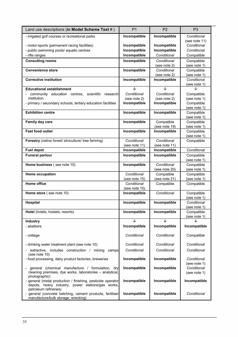
Land use descriptions (in Model Scheme Text # ) P1 P2 P3- irrigated golf courses or recreational parks Incompatible Incompatible Conditional
(see note 11)- motor-sports (permanent racing facilities) Incompatible Incompatible Conditional- public swimming pools/ aquatic centres Incompatible Incompatible Conditional- rifle ranges Incompatible Conditional CompatibleConsulting rooms Incompatible Conditional
(see note 2)Compatible(see note 1)
Convenience store Incompatible Conditional(see note 2)
Compatible(see note 1)
Corrective institution Incompatible Incompatible Conditional(see note 1)
Educational establishment � � �
- community education centres, scientific researchinstitution
Conditional(see note 2)
Conditional(see note 2)
Compatible(see note 1)
- primary / secondary schools, tertiary education facilities Incompatible Incompatible Compatible(see note 1)
Exhibition centre Incompatible Incompatible Compatible(see note 1)
Family day care Incompatible Compatible(see note 19)
Compatible(see note 1)
Fast food outlet Incompatible Incompatible Compatible(see note 1)
Forestry (native forest/ silviculture/ tree farming) Conditional(see note 11)
Conditional(see note 11)
Compatible
Fuel depot Incompatible Incompatible ConditionalFuneral parlour Incompatible Incompatible Compatible
(see note 1)Home business ( see note 10) Incompatible Conditional
(see note 20)Compatible(see note 1)
Home occupation Conditional(see note 15)
Compatible(see note 21)
Compatible(see note 1)
Home office Conditional(see note 15)
Compatible Compatible
Home store ( see note 10) Incompatible Conditional Compatible(see note 1)
Hospital Incompatible Incompatible Conditional(see note 1)
Hotel (hotels, hostels, resorts) Incompatible Incompatible Compatible(see note 1)
Industry � � �
- abattoirs Incompatible Incompatible Incompatible
- cottage Conditional Conditional Compatible
- drinking water treatment plant (see note 10) Conditional Conditional Conditional- extractive, includes construction / mining camps
(see note 10)Conditional Conditional Conditional
- food processing, dairy product factories, breweries Incompatible Incompatible Conditional(see note 1)
- general (chemical manufacture / formulation, drycleaning premises, dye works, laboratories – analytical,photographic)
Incompatible Incompatible Conditional(see note 1)
- general (metal production / finishing, pesticide operatordepots, heavy industry, power stations/gas works,petroleum refineries)
Incompatible Incompatible Incompatible
- general (concrete batching, cement products, fertilisermanufacture/bulk storage, wrecking)
Incompatible Incompatible Conditional

36
Land use descriptions (in Model Scheme Text # ) P1 P2 P3Industry (continued) � � �
- general (mineral processing) Incompatible Incompatible Conditional(see note 9)
- light industry Incompatible Incompatible Conditional(see note 1)
- milk transfer depots Incompatible Incompatible Conditional- mining (includes mineral and energy exploration, oil or
gas extraction / decontamination for transport)Conditional(see note 9)
Conditional(see note 9)
Conditional(see note 9)
- mining (tailings dams) Incompatible Incompatible Conditional(see note 9)
- mining (includes construction / mining camps) ( see note10)
Conditional Conditional Conditional
- rural (animal product rendering works, tanneries, woolscourers)
Incompatible Incompatible Incompatible
- rural (farm supply centres, manure stockpiling /processing facilities)
Incompatible Conditional(see note 2)
Conditional
- rural (forestry products processing– chip mills, pulp/paper, timber preservation, wood/ fibre works,composting/ soil blending - commercial)
Incompatible Incompatible Conditional
- service industry Incompatible Incompatible Conditional
Landfill (solid waste disposal) � � �
- class I (refer also to ‘Storage - used tyres’ land use advice)
Incompatible Incompatible Conditional
- class II or III Incompatible Incompatible Incompatible- class IV or V Incompatible Incompatible IncompatibleLunch bar Incompatible Conditional
(see note 2)Compatible(see note 1)
Major transport infrastructure (roads, railways) Incompatible Conditional(see note 14)
Compatible
Marina NA NA NAMarine filling station (fuelling) NA NA NAMarket (food; general produce; second–hand goods) Incompatible Incompatible Compatible
(see note 1)Medical centre Incompatible Incompatible Compatible
(see note 1)Motel Incompatible Incompatible Compatible
(see note 1)Motor vehicle, boat or caravan sales (sales yards) Incompatible Incompatible Compatible
(see note 1)Motor vehicle repair Incompatible Incompatible Conditional
Motor vehicle wash Incompatible Incompatible ConditionalNational and regional parks and nature reserves Compatible Compatible CompatibleNight club Incompatible Incompatible Compatible
(see note 1)Office Incompatible Conditional Compatible
(see note 1)Park home park Incompatible Incompatible Conditional
(see note 1)Place of worship Incompatible Incompatible Compatible
(see note 1)Plantation Conditional
(see note 11)Conditional
(see note 11)Compatible
Reception centre Incompatible Incompatible Compatible(see note 1)
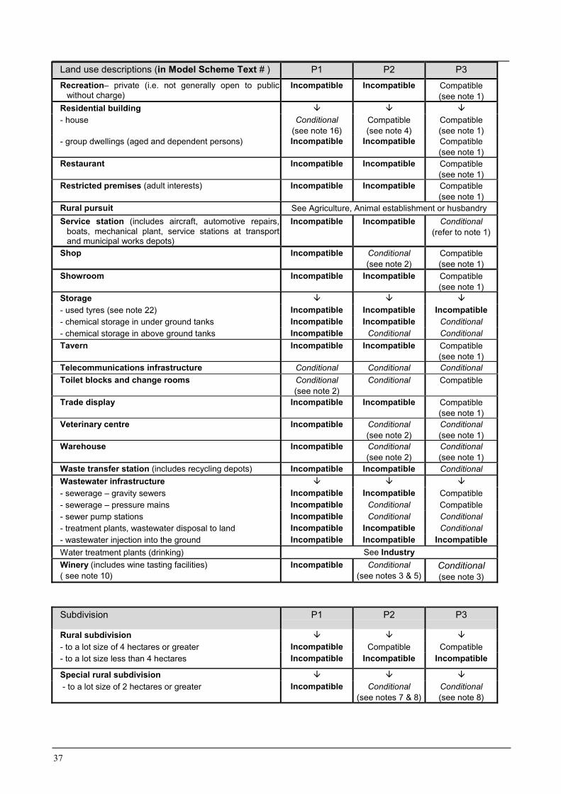
37
Land use descriptions (in Model Scheme Text # ) P1 P2 P3Recreation– private (i.e. not generally open to public
without charge)Incompatible Incompatible Compatible
(see note 1)Residential building � � �
- house Conditional(see note 16)
Compatible(see note 4)
Compatible(see note 1)
- group dwellings (aged and dependent persons) Incompatible Incompatible Compatible(see note 1)
Restaurant Incompatible Incompatible Compatible(see note 1)
Restricted premises (adult interests) Incompatible Incompatible Compatible(see note 1)
Rural pursuit See Agriculture, Animal establishment or husbandryService station (includes aircraft, automotive repairs,
boats, mechanical plant, service stations at transportand municipal works depots)
Incompatible Incompatible Conditional(refer to note 1)
Shop Incompatible Conditional(see note 2)
Compatible(see note 1)
Showroom Incompatible Incompatible Compatible(see note 1)
Storage � � �
- used tyres (see note 22) Incompatible Incompatible Incompatible- chemical storage in under ground tanks Incompatible Incompatible Conditional- chemical storage in above ground tanks Incompatible Conditional ConditionalTavern Incompatible Incompatible Compatible
(see note 1)Telecommunications infrastructure Conditional Conditional ConditionalToilet blocks and change rooms Conditional
(see note 2)Conditional Compatible
Trade display Incompatible Incompatible Compatible(see note 1)
Veterinary centre Incompatible Conditional(see note 2)
Conditional(see note 1)
Warehouse Incompatible Conditional(see note 2)
Conditional(see note 1)
Waste transfer station (includes recycling depots) Incompatible Incompatible ConditionalWastewater infrastructure � � �
- sewerage – gravity sewers Incompatible Incompatible Compatible- sewerage – pressure mains Incompatible Conditional Compatible- sewer pump stations Incompatible Conditional Conditional- treatment plants, wastewater disposal to land Incompatible Incompatible Conditional- wastewater injection into the ground Incompatible Incompatible IncompatibleWater treatment plants (drinking) See IndustryWinery (includes wine tasting facilities)( see note 10)
Incompatible Conditional(see notes 3 & 5)
Conditional(see note 3)
Subdivision P1 P2 P3
Rural subdivision � � �
- to a lot size of 4 hectares or greater Incompatible Compatible Compatible- to a lot size less than 4 hectares Incompatible Incompatible Incompatible
Special rural subdivision � � �
- to a lot size of 2 hectares or greater Incompatible Conditional(see notes 7 & 8)
Conditional(see note 8)
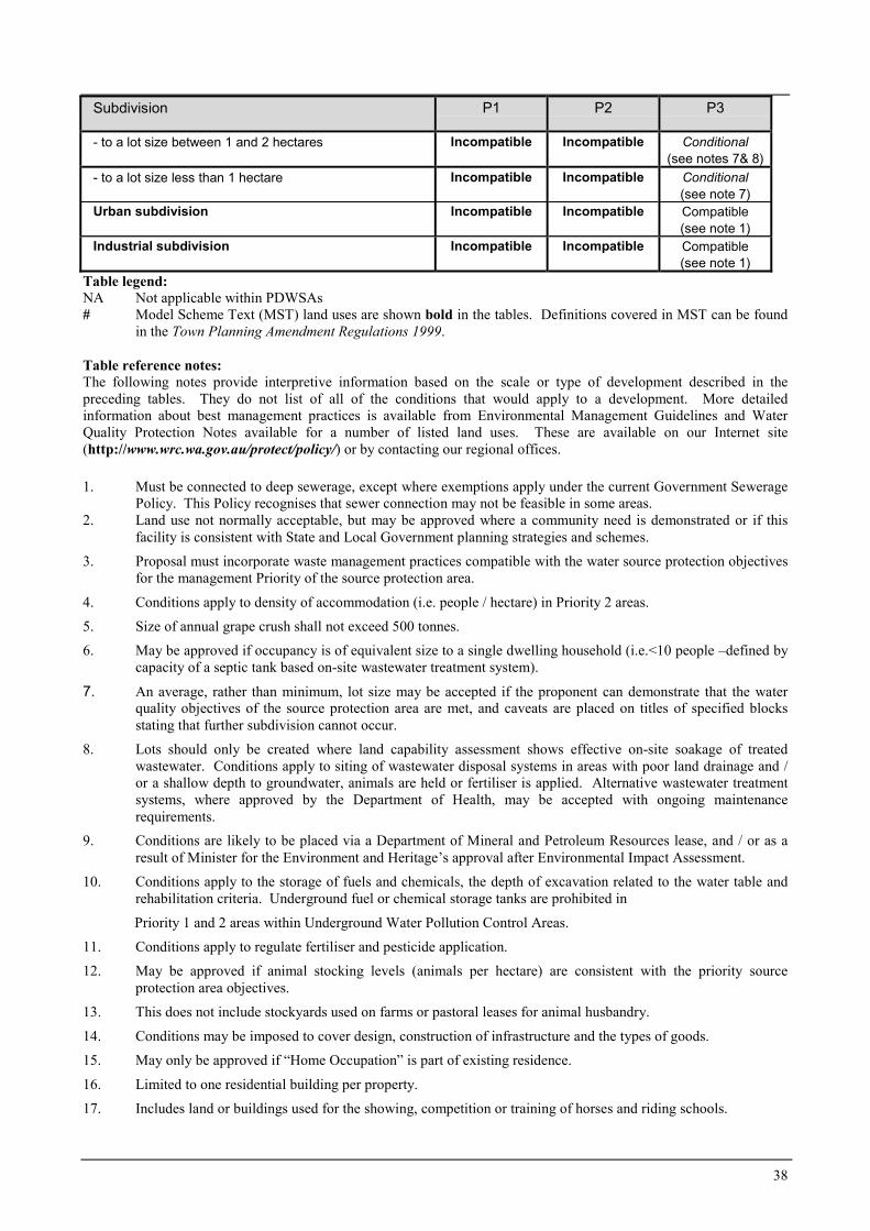
38
Subdivision P1 P2 P3
- to a lot size between 1 and 2 hectares Incompatible Incompatible Conditional(see notes 7& 8)
- to a lot size less than 1 hectare Incompatible Incompatible Conditional(see note 7)
Urban subdivision Incompatible Incompatible Compatible(see note 1)
Industrial subdivision Incompatible Incompatible Compatible(see note 1)
Table legend:NA Not applicable within PDWSAs# Model Scheme Text (MST) land uses are shown bold in the tables. Definitions covered in MST can be found
in the Town Planning Amendment Regulations 1999.
Table reference notes:The following notes provide interpretive information based on the scale or type of development described in thepreceding tables. They do not list of all of the conditions that would apply to a development. More detailedinformation about best management practices is available from Environmental Management Guidelines and WaterQuality Protection Notes available for a number of listed land uses. These are available on our Internet site(http://www.wrc.wa.gov.au/protect/policy/) or by contacting our regional offices.
1. Must be connected to deep sewerage, except where exemptions apply under the current Government SeweragePolicy. This Policy recognises that sewer connection may not be feasible in some areas.
2. Land use not normally acceptable, but may be approved where a community need is demonstrated or if thisfacility is consistent with State and Local Government planning strategies and schemes.
3. Proposal must incorporate waste management practices compatible with the water source protection objectivesfor the management Priority of the source protection area.
4. Conditions apply to density of accommodation (i.e. people / hectare) in Priority 2 areas.
5. Size of annual grape crush shall not exceed 500 tonnes.
6. May be approved if occupancy is of equivalent size to a single dwelling household (i.e.<10 people –defined bycapacity of a septic tank based on-site wastewater treatment system).
7. An average, rather than minimum, lot size may be accepted if the proponent can demonstrate that the waterquality objectives of the source protection area are met, and caveats are placed on titles of specified blocksstating that further subdivision cannot occur.
8. Lots should only be created where land capability assessment shows effective on-site soakage of treatedwastewater. Conditions apply to siting of wastewater disposal systems in areas with poor land drainage and /or a shallow depth to groundwater, animals are held or fertiliser is applied. Alternative wastewater treatmentsystems, where approved by the Department of Health, may be accepted with ongoing maintenancerequirements.
9. Conditions are likely to be placed via a Department of Mineral and Petroleum Resources lease, and / or as aresult of Minister for the Environment and Heritage’s approval after Environmental Impact Assessment.
10. Conditions apply to the storage of fuels and chemicals, the depth of excavation related to the water table andrehabilitation criteria. Underground fuel or chemical storage tanks are prohibited in
Priority 1 and 2 areas within Underground Water Pollution Control Areas.
11. Conditions apply to regulate fertiliser and pesticide application.
12. May be approved if animal stocking levels (animals per hectare) are consistent with the priority sourceprotection area objectives.
13. This does not include stockyards used on farms or pastoral leases for animal husbandry.
14. Conditions may be imposed to cover design, construction of infrastructure and the types of goods.
15. May only be approved if “Home Occupation” is part of existing residence.
16. Limited to one residential building per property.
17. Includes land or buildings used for the showing, competition or training of horses and riding schools.
39
18. Includes any land, building or structure used for the housing, keeping and feeding of horses, asses and mulesand associated incidental activities.
19. In accordance with Community Services (Child Care) Regulations 1988: A child care service provided to achild in a private dwelling in a family of or domestic environment. No more than 5 children of pre-school ageand no more than 7 children under 12 years of age, including the children of the licensee or permit holder.
20. No more than 2 employees and less than or equal to a 50 square metre home business area. Compatible if onlyan office/ administrative business (ie no refuelling, repair or maintenance of commercial/ business vehicles,and no activities involving on-site use or storage of chemicals).
21. Employees shall be members of the household and less than or equal to a 20 square metre home business area.No provision for refuelling, repair or maintenance of commercial/ business vehicles or on-site use or storage ofchemicals.
22. Used tyre use, storage and disposal are subject to Used Tyre Regulations 1996, administered by theEnvironmental Regulation Division of this agency.
More information
We welcome your comments on this note. It will be updated from time to time as feedback is received or land-useactivity standards change. We are progressively developing Water Quality Protection Notes and EnvironmentalManagement Guidelines covering the land uses described in the land use tables.
If you wish to comment on this note, please contact our Resource Quality Branch at the Hyatt Centre in East Perth.Phone: (08) 9278 0300 (business hours);Fax: (08) 9278 0585; orE-mail: Use {feedback} section at our Internet address (http://www.wrc.wa.gov.au), citing the topic & version.
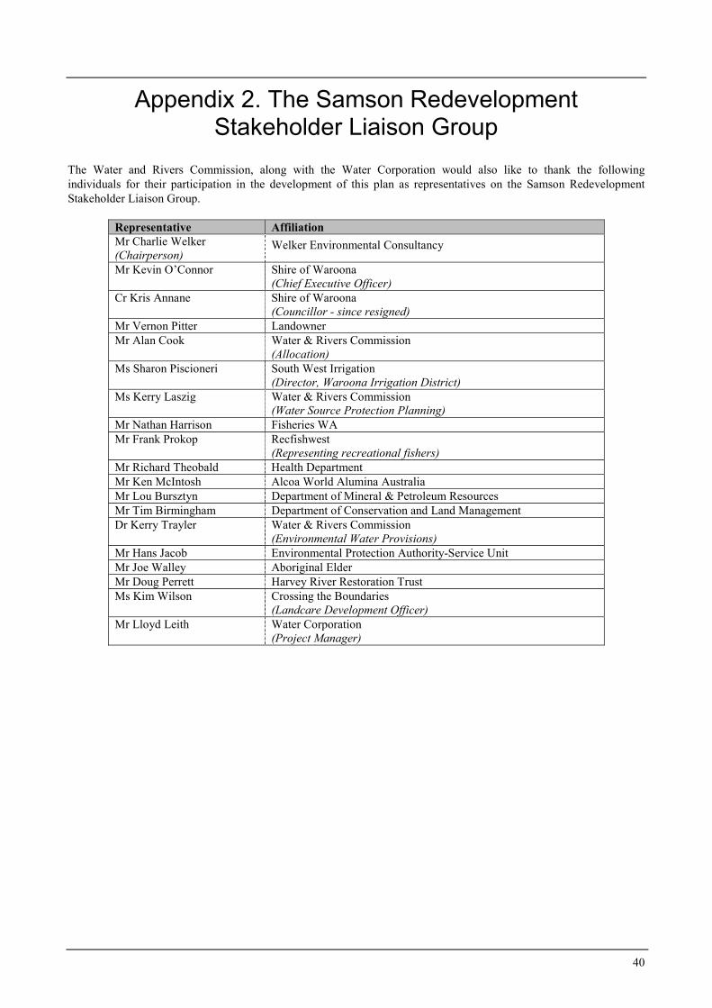
40
Appendix 2. The Samson RedevelopmentStakeholder Liaison Group
The Water and Rivers Commission, along with the Water Corporation would also like to thank the followingindividuals for their participation in the development of this plan as representatives on the Samson RedevelopmentStakeholder Liaison Group.
Representative AffiliationMr Charlie Welker(Chairperson)
Welker Environmental Consultancy
Mr Kevin O’Connor Shire of Waroona(Chief Executive Officer)
Cr Kris Annane Shire of Waroona(Councillor - since resigned)
Mr Vernon Pitter LandownerMr Alan Cook Water & Rivers Commission
(Allocation)Ms Sharon Piscioneri South West Irrigation
(Director, Waroona Irrigation District)Ms Kerry Laszig Water & Rivers Commission
(Water Source Protection Planning)Mr Nathan Harrison Fisheries WAMr Frank Prokop Recfishwest
(Representing recreational fishers)Mr Richard Theobald Health DepartmentMr Ken McIntosh Alcoa World Alumina AustraliaMr Lou Bursztyn Department of Mineral & Petroleum ResourcesMr Tim Birmingham Department of Conservation and Land ManagementDr Kerry Trayler Water & Rivers Commission
(Environmental Water Provisions)Mr Hans Jacob Environmental Protection Authority-Service UnitMr Joe Walley Aboriginal ElderMr Doug Perrett Harvey River Restoration TrustMs Kim Wilson Crossing the Boundaries
(Landcare Development Officer)Mr Lloyd Leith Water Corporation
(Project Manager)
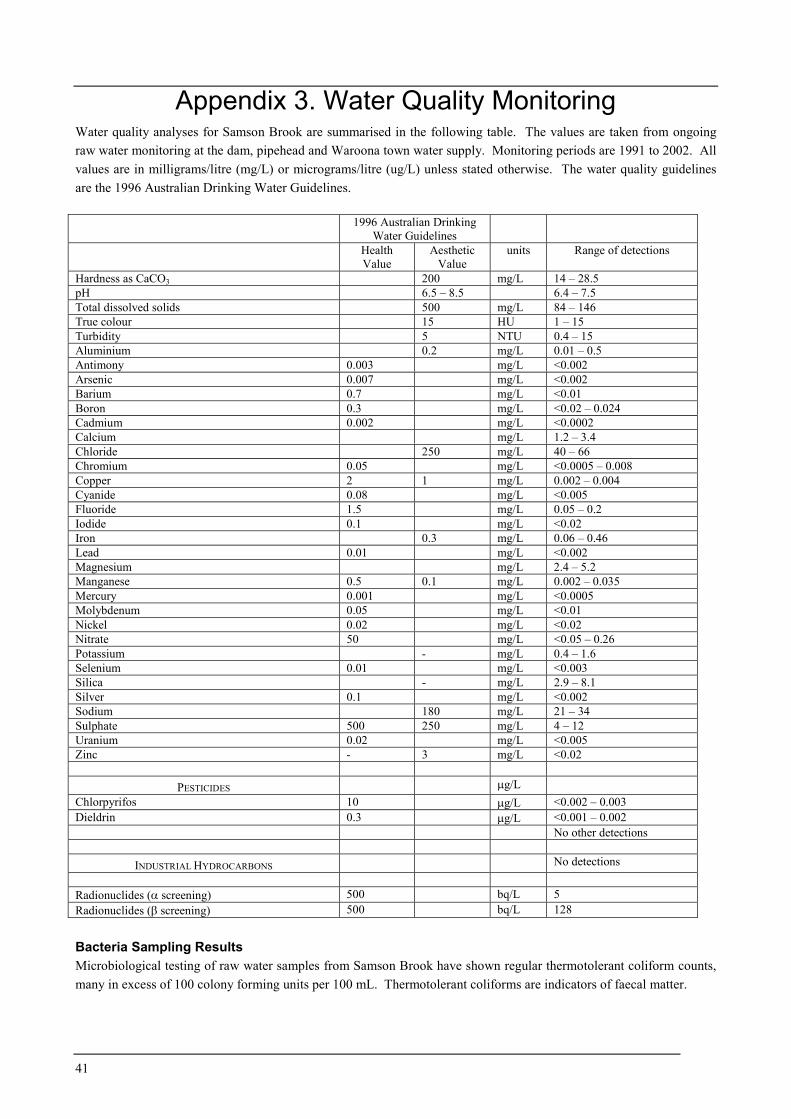
41
Appendix 3. Water Quality MonitoringWater quality analyses for Samson Brook are summarised in the following table. The values are taken from ongoingraw water monitoring at the dam, pipehead and Waroona town water supply. Monitoring periods are 1991 to 2002. Allvalues are in milligrams/litre (mg/L) or micrograms/litre (ug/L) unless stated otherwise. The water quality guidelinesare the 1996 Australian Drinking Water Guidelines.
1996 Australian DrinkingWater Guidelines
HealthValue
AestheticValue
units Range of detections
Hardness as CaCO3 200 mg/L 14 – 28.5pH 6.5 – 8.5 6.4 – 7.5Total dissolved solids 500 mg/L 84 – 146True colour 15 HU 1 – 15Turbidity 5 NTU 0.4 – 15Aluminium 0.2 mg/L 0.01 – 0.5Antimony 0.003 mg/L <0.002Arsenic 0.007 mg/L <0.002Barium 0.7 mg/L <0.01Boron 0.3 mg/L <0.02 – 0.024Cadmium 0.002 mg/L <0.0002Calcium mg/L 1.2 – 3.4Chloride 250 mg/L 40 – 66Chromium 0.05 mg/L <0.0005 – 0.008Copper 2 1 mg/L 0.002 – 0.004Cyanide 0.08 mg/L <0.005Fluoride 1.5 mg/L 0.05 – 0.2Iodide 0.1 mg/L <0.02Iron 0.3 mg/L 0.06 – 0.46Lead 0.01 mg/L <0.002Magnesium mg/L 2.4 – 5.2Manganese 0.5 0.1 mg/L 0.002 – 0.035Mercury 0.001 mg/L <0.0005Molybdenum 0.05 mg/L <0.01Nickel 0.02 mg/L <0.02Nitrate 50 mg/L <0.05 – 0.26Potassium - mg/L 0.4 – 1.6Selenium 0.01 mg/L <0.003Silica - mg/L 2.9 – 8.1Silver 0.1 mg/L <0.002Sodium 180 mg/L 21 – 34Sulphate 500 250 mg/L 4 – 12Uranium 0.02 mg/L <0.005Zinc - 3 mg/L <0.02
PESTICIDES �g/LChlorpyrifos 10 �g/L <0.002 – 0.003Dieldrin 0.3 �g/L <0.001 – 0.002
No other detections
INDUSTRIAL HYDROCARBONS No detections
Radionuclides (� screening) 500 bq/L 5Radionuclides (� screening) 500 bq/L 128
Bacteria Sampling ResultsMicrobiological testing of raw water samples from Samson Brook have shown regular thermotolerant coliform counts,many in excess of 100 colony forming units per 100 mL. Thermotolerant coliforms are indicators of faecal matter.