samuel tucker elementary walkabout: observation: arrival ... drop-off zone - buses: north side of...
TRANSCRIPT

SAMUEL TUCKER
ELEMENTARY WALKABOUT:
Existing Conditions, Findings and
Recommendations
June 2017

SAMUEL TUCKER ELEMENTARY WALKABOUT DETAILS
• Date: March 29, 2017
• Observation: Arrival
• Participants:
• Toole Design Group staff
• City of Alexandria Transportation Planning staff
• Alexandria Bicycle & Pedestrian Advisory Committee members
• Samuel Tucker ES Parents
• Samuel Tucker Administrators
• Purpose:
• Observe school arrival process
• Evaluate school-zone infrastructure
• Assess existing Safe Routes to School programming
2

3
OVERVIEW OF SAMUEL TUCKER ELEMENTARY SCHOOL
84%16%
1 mile >1 mile
As reported in 2016 Parent Survey.
25Total students
Average of “to school” and “from school” modes
as reported in 2016 Student Travel Tallies.
STUDENT DISTANCE FROM SCHOOL
STUDENT TRAVEL MODES
7%
59%
33%
1%

4
STUDENT DISTANCE FROM SCHOOL DETAIL
DistancePercentage
of Students
¼ mile 12%
½ mile 16%
1 mile 48%
2 miles 20%
>2 miles 4%
The hollow circle on the map
represents the direct distance
buffer from the school (1/4 mile).
The colored polygons show the
distance along the road network.
As reported in 2016 Parent Survey

EXISTING CONDITIONS
5

TRAVEL PATTERNS
6
Fall 2016 Student Travel Tallies
6%
1%
59%
33%
1% 0% 0%
7%
1%
60%
32%
0% 0% 0%0%
10%
20%
30%
40%
50%
60%
70%
Walk Bike School Bus Family Vehicle Carpool Transit Other
Morning and Afternoon Travel Mode Comparison
Morning Afternoon

TRAVEL PATTERNS CONTINUED
7
Fall 2016 Parent Survey
Issues reported to affect the decision to not allow a child to walk or bike
to/from school by parents of children who do not walk or bike to/from school
22%
28%
28%
33%
33%
39%
39%
50%
50%
56%
67%
78%
0% 10% 20% 30% 40% 50% 60% 70% 80% 90%
Adults to Bike/Walk With
Convenience of Driving
Child's Participation in After School Programs
Time
Weather or climate
Sidewalks or Pathways
Crossing Guards
Violence or Crime
Distance
Speed of Traffic Along Route
Safety of Intersections and Crossings
Amount of Traffic Along Route
Percent of Responses
Top 3 issues are:
- Amount of traffic along route (78%)
- Safety of Intersections and Crossings (67%)
- Speed of Traffic Along Route (56%)

8
PEDESTRIAN NETWORK
There are two gaps in the
sidewalk network
Sidewalks – Most
sidewalks are at least 4
feet wide, and include a
buffer from the roadway
Crosswalks – Most
Intersections immediately
adjacent to the school
have marked crosswalks
Curb ramps – Curb
ramps are present at most
intersections but many are
missing detectable
warning surfaces
Missing sidewalks to
be constructed by
new development

9
BICYCLING NETWORK
Backlick Run Trail – East-
west trail south of Cameron
Station. Connects to Ben
Brenman Park and Holmes
Run Trail. An extension is
currently in the design phase.
Future Bike Lanes – Many
streets are scheduled for
enhanced bicycle facilities
such as bike lanes or
protected bike lane. These
include:
- Eisenhower Ave.
- multimodal bridge
- Cameron Station Blvd.
- S Pickett St.
- Edsall Rd.

Arrival
- Buses drop off at north loop
- Walkers, car riders, and others enter at main
entrance on south side of building along
Ferdinand Day Dr.
- Campagna (Before-care) – West end of building
Drop-off Zone
- Buses: North side of building along Cameron
Station Blvd.
- Cars: South side of building along Ferdinand
Day Dr. - Alternate Location: Armistead Booth Park Parking Lot
Vehicular Drop-Off
ARRIVAL OBSERVATIONS
Alternate Drop-Off

ARRIVAL OBSERVATIONS
Armistead Boothe Park Parking Lot
- Both teachers and parents use the
parking lot in Armistead Boothe
Park to access Samuel Tucker
Elementary School. With only one
entrance/exit and narrow roadway
conditions, pedestrians and
vehicles come into close contact
as there are no sidewalks and
vehicles must make a three point
turn to exit.
Ferdinand Day Dr. & Cameron
Station Blvd.
- The crossing guard at this location
helps to manage traffic along
Cameron Station Blvd. while
helping students and parents to
cross to Ferdinand Day Dr.
Ferdinand Day Dr. & Harold Secord St.
- The crossing guard at this location
helps to manage student drop-offs
Crossing Guard Location

ENGINEERING
RECOMMENDATIONS
12

INFRASTRUCTURE RECOMMENDATIONS MAP

GENERAL RECOMMENDATIONS WITHIN ½ MILE OF SCHOOL
14
Recommendations
Add additional inverted U bicycle racks near school entrance
Upgrade curb ramps to meet ADA-requirements
Five bike racks are available near the main entrance.

INTERSECTION RECOMMENDATIONS

Map ID Issue Recommendation Timeframe*
1A
Crosswalk is currently missing from the
west leg of the intersection of Ferdinand
Day Dr. and Harold Secord St.
Pedestrians approaching school from
south of Ferdinand Day Dr. must travel
to the marked crossing located one
block west to cross Ferdinand Day Dr.
Add ADA-compliant curb ramp and crosswalk
across Ferdinand Day Dr. on west leg at
intersection with Harold Secord St. Adjust stop
bar and stop sign locations accordingly.
Short
1B
Curb ramp is missing on the west end of
south leg at the intersection of Cameron
Station Blvd. & Harold Secord St. Curb
ramp on NW corner lacks detectable
warning surface.
Install ADA-compliant curb ramp and add
detectable warning surface to remaining curb
ramps
Short
* Short = within 1 year, Medium = within 3 years, Long = 3 or more years
INTERSECTION RECOMMENDATIONS
16
Proposed Crosswalk
Location
Existing indirect path

INTERSECTION RECOMMENDATIONS
17
Missing curb ramps at Harold Secord St. &
Cameron Station Blvd.
Missing crosswalk and curb ramp at
intersection of Ferdinand Day Dr. and Harold
Secord St.

MID-BLOCK CROSSINGS

Map ID Issue Recommendation Timeframe*
2A
There are no marked crossings
between Harold Secord St. and S
Pickett St. across Cameron Station
Blvd. Students and parents travelling
from north of Cameron Station Blvd.
who wish to access the school or
Campagna program via a marked
crosswalk must take an indirect
route.
Install high visibility marked crosswalk across Cameron
Station Blvd. at existing curb cut on NW corner of school
property. Also install curb extension on north side to
shorten crossing distance and increase pedestrian
visibility.
Medium
* Short = within 1 year, Medium = within 3 years, Long = 3 or more years
MID-BLOCK CROSSINGS
19
Left: Curb ramp and future
location for crosswalk across
Cameron Station Blvd.

SCHOOL ZONE SIGNAGEAdditional Detail on
Following Slide

21
SCHOOL ZONE SIGNAGE
Map ID Issue Recommendation Timeframe*
3A
Speed limit along Ferdinand Day Dr. is 25
mph while speed limit along Cameron
Station Blvd. is 15 mph with flashing
school zone beacon.
Reduce speed limit to 15 mph and
add flashing school zone beacon to
Ferdinand Day Dr.
Short
* Short = within 1 year, Medium = within 3 years, Long = 3 or more years
Cameron Station Blvd. Cameron Station Blvd. Ferdinand Day Drive

SIGNALIZED INTERSECTIONSAdditional Detail on
Following Slide

23
SIGNALIZED INTERSECTIONS
Map ID Issue Recommendation Timeframe*
4A
“Right Turn Watch for Pedestrians”
signage obscured by other
signage
Reconfigure signage so each sign is clearly
visible.Short
4B
Curb ramp at NW corner not ADA-
compliant due to lack of gap in
detectable warning surface
Add separating island between crosswalks to
break up detectable warning surface Short
Insufficient pedestrian crossing
time
Provide Leading Pedestrian Interval and
extended walk phase when push button
activated. Alternatively, provide pedestrian-only
phase during arrival and dismissal to allow
students to safely cross.
Medium
Presence of slip lanes
Provide raised crosswalk across slip lane.
NOTE: Limited ROW prevents the elimination of
slip lanes.
Long
* Short = within 1 year, Medium = within 3 years, Long = 3 or more years
Left: A gap in the detectable
warning surface should be added in
order to indicate which direction
crosswalks are in.

OTHER RECOMMENDATIONSAdditional Detail on
Following Slide
25
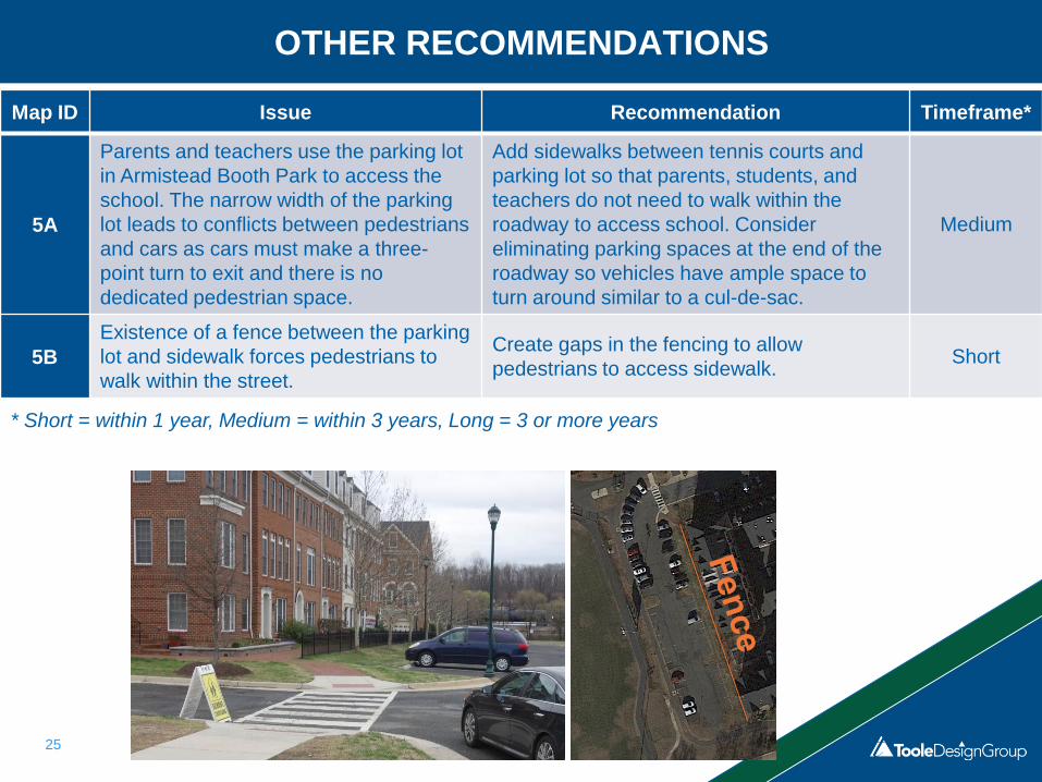
OTHER RECOMMENDATIONS
Map ID Issue Recommendation Timeframe*
5A
Parents and teachers use the parking lot
in Armistead Booth Park to access the
school. The narrow width of the parking
lot leads to conflicts between pedestrians
and cars as cars must make a three-
point turn to exit and there is no
dedicated pedestrian space.
Add sidewalks between tennis courts and
parking lot so that parents, students, and
teachers do not need to walk within the
roadway to access school. Consider
eliminating parking spaces at the end of the
roadway so vehicles have ample space to
turn around similar to a cul-de-sac.
Medium
5B
Existence of a fence between the parking
lot and sidewalk forces pedestrians to
walk within the street.
Create gaps in the fencing to allow
pedestrians to access sidewalk.Short
* Short = within 1 year, Medium = within 3 years, Long = 3 or more years

Reconfigured Drop-Off
26
Drop-off

OTHER RECOMMENDATIONS
27
The Armistead Boothe Park parking lot is a
frequent location for student drop-offs/pick-
ups. The narrow width of the parking lot forces
vehicles to back up to exit. The addition of a
sidewalk would provide a safe place for
students and parents to walk to school.

ROADWAY IMPROVEMENTSAdditional Detail on
Following Slide

29
ROADWAY IMPROVEMENTS
Map ID Issue Recommendation Timeframe*
6ALack of bicycle infrastructure along
Cameron Station Blvd.
Install bicycle infrastructure in
accordance with the Bicycle and
Pedestrian Master Plan.
Medium
6B
Lanes along Cameron Station Blvd. are
as wide as 24’ west of Ferdinand Day Dr.
leading to higher vehicular speeds.
Narrow vehicular lanes to slow traffic
and add a painted center median,
shoulder, or bike lanes.
Medium
6C
The speed limit along S Pickett St. is 25
mph west of Edsall Rd. and 35 mph east
of Edsall Rd.
Reduce posted speed limit east of
Edsall Rd. to 25 mph and install lane
diet to reduce vehicular speeds.
Medium
* Short = within 1 year, Medium = within 3 years, Long = 3 or more years
Cameron Station Blvd. S Pickett St.

PROGRAMMATIC
RECOMMENDATIONS
30

EDUCATION
Recommendation
Continue
Existing
Start
New
Integrate pedestrian and bicycle safety education into the school
curriculum. •Conduct a bicycle rodeo to teach the skills and precautions to ride a
bike safely. •Incorporate information about walking and bicycling to school in
communications with parents. •Provide parents and guardians with safe driving information that
stresses the importance of driving safely in school zones and being
alert for pedestrians and bicyclists during arrival and dismissal.•
31

ENCOURAGEMENT
Recommendation
Continue
Existing
Start
New
Participate in International Walk to School Day and Bike to
School Day. •Help organize and support walking schools buses.
•Help organize and support bike trains.
•Establish a frequent walker / bicyclist program.
•
32

ENFORCEMENT
Recommendation
Continue
Existing
Start
New
Establish a driver pledge program.•
Celebrate Virginia Crossing Guard Appreciation Day.•
Work with the police department to provide periodic parking and
traffic enforcement near the school. •
33

EVALUATION
Recommendation
Continue
Existing*
Start
New
Conduct Student Travel Tallies to get baseline data for student
travel patterns. •Administer Parent Surveys to collect information on parents’
attitudes towards walking and bicycling and reasons why they
may or may not allow their children to walk or bike to school.
•
34
*Travel Tallies were last collected in the fall of 2016 and Parent Surveys were conducted
in the fall of 2016 at Samuel Tucker Elementary School. Up to date information is
required to monitor program success and apply for federal SRTS funding.