san francisco water and power a h of - sfpuc
TRANSCRIPT

History A
Hetch Hetchy System
the
&Municipal Water Department
of
S A N F R A N C I S C O W A T E R A N D P O W E R
SAN FRANCISCO PUBLIC UTILITIES COMMISSION

This 2005 edition of San
Francisco Water and Power,
A History of the Municipal
Water Department and Hetch Hetchy
System celebrates the extraordinaryevents and memorable leaders whoconceived, designed and built SanFrancisco’s water system with fore-sight to provide today’s Bay Areawith high quality drinking water supplies. San Francisco’s water system developed over time from the streams and wells of its earliestdays to today’s complex system of dams, reservoirs, tunnels andpipelines that brings water from thehigh Sierra Nevada by gravity acrossCalifornia to join from the East Bayand San Francisco Peninsula.
San Francisco’s need for reliablewater supplies after the devastationof the Great Earthquake and Fire of1906 brought the brightest engineersof their day to meet the challengesof hydraulic engineering across morethan 160 miles of wilderness, devel-oping new technologies and con-struction techniques, masteringimpassable terrain and intractablefinancial woes to complete theincredible water works that fostersthe high quality of life and economicstrength that our 21st century SanFrancisco Bay Area enjoys.
San Francisco Water and Power
traces water flow from householdtaps back to the sources - throughthe city’s distribution system, BayArea pipelines and tunnels to thestorage reservoirs in the Peninsulaand East Bay, across the San JoaquinValley and through the foothillpipelines, tunnels and hydroelectricpower plants in the Mother Lode, upthrough the mountain tunnels to thedams and impounding reservoirs inthe high Sierra Nevada to MountLyell in Yosemite National Park - theultimate source of San Francisco’swater and power resources.
The first seven decades of SanFrancisco’s municipal water supplystory is about the development oflocal water sources by entrepreneur-ial water companies, including thebrilliant water system designed bythe Spring Valley Water Company, aprivate enterprise, that brought watersupplies from within San Francisco,
on the Peninsula and across SanFrancisco Bay to meet the demandsof a burgeoning city. San Franciscopurchased the fully developed,mature Spring Valley water works in 1930 at a cost of $39,962,606.51.
The Hetch Hetchy Project had itsbirth in the Raker Act of 1913, whichgranted the City water and powerrights-of-way on the Tuolumne Riverin Yosemite National Park. The entiresystem is the realization of a conceptplanned since the 1860’s for an aqueduct from the Sierra Nevadawatersheds to San Francisco. In 1934,mountain water supplies first reachedthe San Francisco Peninsula, twentyyears after construction started, representing an investment by thepeople of San Francisco of morethan $100 million. The system wasengineered to deliver Hetch Hetchysupplies entirely bygravity to the region-al Bay Area.Integration of theHetch Hetchy aque-duct with local waterstorage and deliverysystems provides San Francisco andits neighboring communities with anassured supply of high quality drink-
ing water to meet their changingneeds.
The San Francisco Public UtilitiesCommission recently initiated amajor, multi-billion dollar water sys-tem improvement program to rebuildits aging water system in response toconcerns about increasing vulnerabil-ity to service disruptions in a majorseismic event, or from a prolongeddrought. Plans are in place toupgrade, replace or augment criticalfacilities to ensure the San FranciscoBay Area continues to receive reli-able, high quality water supplies into the future.
Editors, June 2005
P R E F A C E
Tueeulala Falls
To those who dreamand carry on unsung
I. SAN FRANCISCO’S EARLY WATER SOURCESFirst Water Works . . . . . . . . . . . . . . . . . . . . . . . . . . . . . . . . . . . . . . . . . . . . . . . . . 2
Spanish Rule. . . . . . . . . . . . . . . . . . . . . . . . . . . . . . . . . . . . . . . . . . . . . . . . . . . 2First Settlements . . . . . . . . . . . . . . . . . . . . . . . . . . . . . . . . . . . . . . . . . . . . . . . . 2The Gold Rush . . . . . . . . . . . . . . . . . . . . . . . . . . . . . . . . . . . . . . . . . . . . . . . . . 3Impact of the Gold Rush. . . . . . . . . . . . . . . . . . . . . . . . . . . . . . . . . . . . . . . . . . 3A. W. von Schmidt and the First Water Works . . . . . . . . . . . . . . . . . . . . . . . . . . 4Pilarcitos Dam and Reservoir. . . . . . . . . . . . . . . . . . . . . . . . . . . . . . . . . . . . . . . 5What’s in a Name? The Disappearance of the “San Andrés Valley” . . . . . . . . . . 6
Spring Valley Water Company . . . . . . . . . . . . . . . . . . . . . . . . . . . . . . . . . . . . . . . 8Hermann Schussler . . . . . . . . . . . . . . . . . . . . . . . . . . . . . . . . . . . . . . . . . . . . . . 8San Andreas Dam and Reservoir . . . . . . . . . . . . . . . . . . . . . . . . . . . . . . . . . . . . 8Stone Dam . . . . . . . . . . . . . . . . . . . . . . . . . . . . . . . . . . . . . . . . . . . . . . . . . . . . 9Upper Crystal Springs Dam and Reservoir . . . . . . . . . . . . . . . . . . . . . . . . . . . . 10Lower Crystal Springs Dam and Reservoir . . . . . . . . . . . . . . . . . . . . . . . . . . . . 10Crystal Springs Pump Station . . . . . . . . . . . . . . . . . . . . . . . . . . . . . . . . . . . . . . 11Sunol Filter Beds and Pleasanton Well Field. . . . . . . . . . . . . . . . . . . . . . . . . . . 11Sunol Water Temple . . . . . . . . . . . . . . . . . . . . . . . . . . . . . . . . . . . . . . . . . . . . 12Castlewood Wells . . . . . . . . . . . . . . . . . . . . . . . . . . . . . . . . . . . . . . . . . . . . . . 12Calaveras Dam and Reservoir . . . . . . . . . . . . . . . . . . . . . . . . . . . . . . . . . . . . . 13
San Francisco Water Department . . . . . . . . . . . . . . . . . . . . . . . . . . . . . . . . . . . 14Purchase of Spring Valley Water Company. . . . . . . . . . . . . . . . . . . . . . . . . . . . 14Turner Dam and San Antonio Reservoir. . . . . . . . . . . . . . . . . . . . . . . . . . . . . . 14City Distribution System . . . . . . . . . . . . . . . . . . . . . . . . . . . . . . . . . . . . . . . . . 15
Water Quality and Treatment . . . . . . . . . . . . . . . . . . . . . . . . . . . . . . . . . . . . . . . 16Environmental Stewardship and Watershed Protection . . . . . . . . . . . . . . . . . . . 16Sunol Valley Water Treatment Plant . . . . . . . . . . . . . . . . . . . . . . . . . . . . . . . . . 17Harry W. Tracy Water Treatment Plant . . . . . . . . . . . . . . . . . . . . . . . . . . . . . . . 18Water Treatment Processes . . . . . . . . . . . . . . . . . . . . . . . . . . . . . . . . . . . . . . . 18
II. SAN FRANCISCO SEARCHES FOR WATERSearch for New Water Sources . . . . . . . . . . . . . . . . . . . . . . . . . . . . . . . . . . . . . . 20
Carl Grunsky’s Investigation . . . . . . . . . . . . . . . . . . . . . . . . . . . . . . . . . . . . . . 20Tuolumne River Looks Promising . . . . . . . . . . . . . . . . . . . . . . . . . . . . . . . . . . 211906 Great Earthquake and Fire . . . . . . . . . . . . . . . . . . . . . . . . . . . . . . . . . . . 22Story of an Eyewitness . . . . . . . . . . . . . . . . . . . . . . . . . . . . . . . . . . . . . . . . . . . 22Renewed Interest in Hetch Hetchy . . . . . . . . . . . . . . . . . . . . . . . . . . . . . . . . . 23
Battle for Hetch Hetchy . . . . . . . . . . . . . . . . . . . . . . . . . . . . . . . . . . . . . . . . . . . 24John R. Freeman’s Plan for Hetch Hetchy . . . . . . . . . . . . . . . . . . . . . . . . . . . . 24The Raker Act. . . . . . . . . . . . . . . . . . . . . . . . . . . . . . . . . . . . . . . . . . . . . . . . . 25Battle for Senate Approval. . . . . . . . . . . . . . . . . . . . . . . . . . . . . . . . . . . . . . . . 25San Francisco Examiner Tips Senate Support . . . . . . . . . . . . . . . . . . . . . . . . . 26Raker Act Preserves Wilderness . . . . . . . . . . . . . . . . . . . . . . . . . . . . . . . . . . . . 26Raker Act Provisions . . . . . . . . . . . . . . . . . . . . . . . . . . . . . . . . . . . . . . . . . . . . 27
T A B L E O F C O N T E N T S
San Francisco Water & PowerHistory of the Municipal Water Department & Hetch Hetchy System

III. SAN FRANCISCO BUILDS HETCH HETCHY PROJECTHetch Hetchy Railroad . . . . . . . . . . . . . . . . . . . . . . . . . . . . . . . . . . . . . . . . . . . . 29
Chief Engineer Michael M. O’Shaughnessy. . . . . . . . . . . . . . . . . . . . . . . . . . . . 29Hetch Hetchy System Design. . . . . . . . . . . . . . . . . . . . . . . . . . . . . . . . . . . . . . 29Water Supply for Bay Area . . . . . . . . . . . . . . . . . . . . . . . . . . . . . . . . . . . . . . . 30Design Decisions . . . . . . . . . . . . . . . . . . . . . . . . . . . . . . . . . . . . . . . . . . . . . . 31Groveland Headquarters . . . . . . . . . . . . . . . . . . . . . . . . . . . . . . . . . . . . . . . . . 31Hetch Hetchy Railroad . . . . . . . . . . . . . . . . . . . . . . . . . . . . . . . . . . . . . . . . . . 32The Sawmill . . . . . . . . . . . . . . . . . . . . . . . . . . . . . . . . . . . . . . . . . . . . . . . . . . 32Early Intake Powerhouse and Lake Eleanore . . . . . . . . . . . . . . . . . . . . . . . . . . 32
Dam & Tunnel Construction Starts in High Sierra . . . . . . . . . . . . . . . . . . . . . . 34O’Shaughnessy Dam and Hetch Hetchy Reservoir . . . . . . . . . . . . . . . . . . . . . . 34Mountain Tunnel . . . . . . . . . . . . . . . . . . . . . . . . . . . . . . . . . . . . . . . . . . . . . . 34Priest Reservoir and Bypass. . . . . . . . . . . . . . . . . . . . . . . . . . . . . . . . . . . . . . . 35
Construction Begins in Sierra Foothills . . . . . . . . . . . . . . . . . . . . . . . . . . . . . . 36Moccasin Power Tunnel . . . . . . . . . . . . . . . . . . . . . . . . . . . . . . . . . . . . . . . . . 36Old Moccasin Powerhouse and Camp . . . . . . . . . . . . . . . . . . . . . . . . . . . . . . . 36New Moccasin Powerhouse and Re-regulating Reservoir . . . . . . . . . . . . . . . . . 36Foothill Tunnel . . . . . . . . . . . . . . . . . . . . . . . . . . . . . . . . . . . . . . . . . . . . . . . . 37
Aqueduct Spans Northern California . . . . . . . . . . . . . . . . . . . . . . . . . . . . . . . . 38San Joaquin Pipelines . . . . . . . . . . . . . . . . . . . . . . . . . . . . . . . . . . . . . . . . . . . 38Coast Range Tunnel and Construction Delays . . . . . . . . . . . . . . . . . . . . . . . . . 38Disastrous Explosion - 12 Lives Lost . . . . . . . . . . . . . . . . . . . . . . . . . . . . . . . . 39O’Shaughnessy Blamed for Delays. . . . . . . . . . . . . . . . . . . . . . . . . . . . . . . . . . 39Bay Crossing Pipeline No. 1 - Spring Valley Finances Start of Construction . . . . 40Bay Division Pipelines Nos. 2, 3 and 4 . . . . . . . . . . . . . . . . . . . . . . . . . . . . . . 41
Hetch Hetchy Water Reaches San Francisco Peninsula . . . . . . . . . . . . . . . . . . 42Crystal Springs Bypass Tunnel . . . . . . . . . . . . . . . . . . . . . . . . . . . . . . . . . . . . . 42Pulgas Water Temple. . . . . . . . . . . . . . . . . . . . . . . . . . . . . . . . . . . . . . . . . . . . 42O’Shaughnessy Tragically Misses Historic Day . . . . . . . . . . . . . . . . . . . . . . . . . 42
Hetch Hetchy Hydroelectric System . . . . . . . . . . . . . . . . . . . . . . . . . . . . . . . . . 43Cherry Valley System. . . . . . . . . . . . . . . . . . . . . . . . . . . . . . . . . . . . . . . . . . . . 43Dion R. Holm Powerhouse . . . . . . . . . . . . . . . . . . . . . . . . . . . . . . . . . . . . . . . 44Canyon Power Tunnel . . . . . . . . . . . . . . . . . . . . . . . . . . . . . . . . . . . . . . . . . . 44Robert C. Kirkwood Powerhouse. . . . . . . . . . . . . . . . . . . . . . . . . . . . . . . . . . . 44Power Transmission Lines . . . . . . . . . . . . . . . . . . . . . . . . . . . . . . . . . . . . . . . . 45New Don Pedro Dam and Reservoir . . . . . . . . . . . . . . . . . . . . . . . . . . . . . . . . 45
Rebuilding San Francisco’s System . . . . . . . . . . . . . . . . . . . . . . . . . . . . . . . . . 46Loma Prieta Earthquake Tests Water System. . . . . . . . . . . . . . . . . . . . . . . . . . . 46Rebuilding San Francisco’s Water System . . . . . . . . . . . . . . . . . . . . . . . . . . . . . 46Sustainability Planning. . . . . . . . . . . . . . . . . . . . . . . . . . . . . . . . . . . . . . . . . . . 47
IV. APPENDICESChronology. . . . . . . . . . . . . . . . . . . . . . . . . . . . . . . . . . . . . . . . . . . . . . . . . . . . . 49General Managers. . . . . . . . . . . . . . . . . . . . . . . . . . . . . . . . . . . . . . . . . . . . . . . . 55Acknowledgements . . . . . . . . . . . . . . . . . . . . . . . . . . . . . . . . . . . . . . . . . . . . . . 56
T A B L E O F C O N T E N T S

SAN FRANCISCO’S
EARLY WATER SOURCES

The seed for San Francisco’smunicipal quest for drinkingwater was sown in 1769, when
Don Gaspar de Portola and JoseFrancisco Ortega reconnoitered thePeninsula and discovered SanFrancisco Bay. Padre Juan Crespirecorded the tortuous trek in his diary.The seed was watered in 1773 by theexploratory expedition of FernandoRivera y Moncada and Padre FranciscoPalou. Palou returned to the tip of the50-mile-long peninsula with JuanBatista de Anza in 1776 when theyfounded Presidio Pueblo, a militarytown, and Mission San Francisco.
The area is favored with a mild, mar-itime climate. But the site they selectedwas bounded on three sides by the salt water of the Pacific Ocean and San Francisco Bay, and lay in the cen-ter of a region geographically classifiedas semi-arid. The seed of the quest forwater took root.
SPANISH RULE
Unlike some of Spain’s earlier coloniesin the New World, the Alta Californiahad never been the site of a highlydeveloped indigenous civilization. Nopublic works existed -- neither cities,roads, reservoirs nor aqueducts.
Casual local water sources were ade-quate for the Presidio Pueblo andMission. The soldiers and their familiestook their water from Laguna delPresidio (Mountain Lake), Arroyo delPuerto (Lobos Creek) and severalsprings, including El Polin, near theencampment. Mountain Lake andPolin Spring continue to producewater, though not potable. LobosCreek continues to supply over twomillion gallons a day (MGD) to thePresidio of San Francisco.
Anza located Mission San Francisconear the ojo de agua, or small stream,which he named Arroyo de losDolores. Originating on the heights ofwhat is now called Twin Peaks, thestream generally followed the line of18th Street into Laguna de Manantial,or Lake Dolores, which emptiedthrough Mission Creek into MissionBay (China Basin), originally calledEnsenada de los Llorones.
Dolores Lake and Stream have longsince been filled in and built over. A portion of Mission Creek and Baycan still be found between Berry and Channel Streets from 7th Street to China Basin. The name Doloresremains on the street fronting theMission, the Mission chapel, a churchbuilt adjacent to the chapel much later,and a nearby neighborhood park.
Under Spanish royal rule, the PresidioPueblo and Mission shared the placid,uneventful life common to all settle-ments in the California province. Lifewas slow moving and confined to thePresidio Pueblo and Mission grounds.Visits by Spain’s galleons brought oldworld luxuries and political instructionsfrom Mexico. Spain kept Alta Californiaisolated. Visits by foreigners were notencouraged.
FIRST SETTLEMENTS
When Spain’s royal rule over YerbaBuena and California was ended in1821, Mexico opened Mission lands tosettlement under the Secularization Actof 1833. Longstanding isolation policieswere broken down, relaxing economicand political barriers to foreign com-merce. Trade ships, hide droghers andwhalers entering San Francisco Bayfound anchorage at Yerba Buena Cove,
just north of the present-day FerryBuilding, better that at the Presidioanchorage favored by the Spanishgalleons. Mexican Governor Figueroaestablished a trading post at YerbaBuena Cove and named William A.Richardson, an Englishman, as harbormaster.
A settlement grew at the Cove to service and do business with the visit-ing ships. The original trails that connected the Presidio Pueblo to the Mission and thence south, werejoined by additional tracks to the new Mexican pueblo growing on the Yerba Buena shore.
There wasn’t much of a settlement yet in December 1835, when RichardHenry Dana, Jr., who later authoredthe great 1840 American classic, Two
Years Before the Mast, was a 20-year-old crew member aboard the Bostondrogher, Alert, laying at anchor in theCove. Twenty-four years later he remi-nisced,
It was in the winter of 1835-36 that
the ship Alert, in the prosecution of
her voyage for hides on the remote
and almost unknown coast of
California, floated into the vast soli-
tude of the Bay of San Francisco.
Our anchorage was between a small
island, called Yerba Buena, and a
2 San Francisco Water and Power
F I R S T W A T E R W O R K S
Washington Square, San Francisco 1862 July 4th Celebration

gravel beach in a little bight or cove
of the same name, formed by two
projecting points. Beyond, to the
westward of the landing place, were
dreary sand hills, with little grass to
be seen, and a few trees, and beyond
them higher hills, steep and barren,
their sides gullied by the rains. Some
five or six miles beyond the landing-
place, to the right, was a ruinous
presidio, and some three or four
miles to the left was the Mission of
Dolores, as ruinous as the presidio,
almost deserted, with but few Native
Americans attached to it, and but lit-
tle property in cattle. Over a region
far beyond our sight there were no
other human habitations, except a
shanty of rough boards, put up by a
man years in advance of his time,
named Richardson, who carried on
a very small retail trade between the
hide ships and the Indians. The next
year Richardson built a one-story
adobe house on the same spot, which
was long afterwards known as the
oldest house in the great city of San
Francisco.
Richardson’s 1836 pretentious one-storyadobe was the Casa Grande. It stoodnear Clay Street and Grant Avenueuntil 1852. The Pueblo of Yerba Buena,a town government organized by 450residents, was overtaken by the U.S.S.
Portsmouth, commanded by Captain R. B. Montgomery, on July 9, 1846.Montgomery appointed his lieutenant,Washington Bartlett, who was bilingual,to be the first American Alcalde orMayor. Bartlett proclaimed the name ofthe Pueblo to be San Francisco.
THE GOLD RUSH
During the somnolent days of YerbaBuena, after Dana’s visit and before theGold Rush, San Franciscans took theirwater from a few streams, springs andwells. These sources were no longeradequate by 1849, so householdersbought water by the barrel. Water ped-dlers competed in the streets with bar-rels in carts serving regular waterroutes. Some had barrels slung acrossthe back of a donkey. A footnote inhistory identifies one such entrepre-neur as Juan Miguel Aguirre, who tookwater from several locations. During
periods of scarcity, Señor Aguirrereportedly charged as much as onedollar in gold for a bucket of drinkingwater, his thriving business earningsome $30 a day.
In 1851, the Sausalito Water and SteamTug Company was barging the pre-cious fluid across the bay by tanksteamer from springs on the Marinshore, using some 65 water carts tosupply San Francisco households. Thatsame year, the Mountain Lake WaterCompany was formed to bring waterfrom Mountain Lake in the Presidio.
Within the two years, 1850-1852, SanFrancisco was entirely destroyed by firesix times, with staggering losses ofproperty, and was as often rebuilt. By1859, the city was solidly built of brickand stone with nearly 100,000 inhabi-tants having all the accomplishments ofwealth and culture. They also had
vivid, fresh memories of wide-spreadconflagrations and never enough waterfor fire fighting.
IMPACT OF THE GOLD RUSH
In excerpts from Theodore H. Hittell’s1897 History of California, Vol. II, hedescribes the rush of adventurers overland and by sea to the gold mines westof San Francisco. In one year, 1849, thepopulation of California swelled toover 100,000, many skilled in tradesand crafts, who emigrated from allregions of the country and around theworld to seek their fortune in theSacramento hills.
The earliest important notice of the
gold discovery, which appeared in
the Atlantic States, was published in
the Baltimore Sun newspaper on
September 20, 1848. But by that time
private letters from the Pacific coast,
San Francisco Water and Power 3
Miners pan for gold circa 1850
Ph
oto
cre
dit
: h
isto
rich
wy49.c
om

filled with the wonderful story, had
commenced reaching their destina-
tions. Those of the recipients, who
had faith in their correspondents,
believed; but for several months the
general public heard with increduli-
ty. The private letters urged relatives
and friends to sell out at almost any
sacrifice and start at once for
California. Friends compared letters,
which all gave the same account
and the same advice. Doubt began
to vanish and enterprising men to
prepare for the grand exodus.
Everybody began to talk about
California.
The people were in a ripe state for
adventurous emigration. The
Mexican war, besides stimulating
enterprise, had thrown upon the
country numbers of vigorous young
men, inured to travel and hardships,
without regular employments, and
ready for new campaigns which
promised unlimited rewards of
wealth; while in every state there
were numbers of all classes eager to
better their condition and contemp-
tuous, in the face of the accounts
they received, of suggestions of doubt
or difficulty or danger. Very soon
after the first public notice appeared,
all the newspapers from one end of
the country to the other were full of
the subject. It everywhere became the
topic of conversation and discussion.
The arrival of newer accounts and
larger consignments of gold served to
confirm and increase the feeling
and it rapidly grew all absorbing-
first into an excitement and then
into what was called a fever. It soon
became certain that there would be
a grand rush for the gold mines...
Immense numbers of trains or
caravans of emigrants, with covered
wagons usually drawn, by oxen,
started on their way from the west-
ern frontiers across the plains. There
was a continuous stream of them,
which, by the time the first ships
from the Atlantic ports reached San
Francisco, stretched across the conti-
nent and began pouring over the
Sierra Nevada into the Sacramento
and San Joaquin valleys. It presented
a sight that had not been seen before
and may not be seen again...
San Francisco’s search for increasingquantities of potable water attemptedto keep pace with the rapid growthand development of that sleepy pueblointo a major world metropolis. Thesudden birth and overnight develop-
ment of this city during the Gold Rushsparked a dynamic municipal quest fornew sources of drinking water.
A. W. VON SCHMIDT AND THE FIRST WATER WORKS
After a two-year effort, the MountainLake Water Company ran out of moneyin 1853, and was granted the first ofseveral time extensions to bring waterfrom Mountain Lake. In 1856, the SanFrancisco City Water Works, popularlyknown as the Bensley Company, wasfranchised by San Francisco Order No.46. The next year, Alexei Waldemarvon Schmidt, the chief engineer of theBensley Company, dammed the mouthof Lobos Creek and brought two mil-lion gallons of water a day by flumeand tunnel around Fort Point, throughthe Presidio and under Fort Mason, tothe Black Point Pumping Station at thefoot of Van Ness Avenue. The LobosCreek water was then pumped throughtwo sets of heavy double-force pipesto the Francisco (elevation 135 feet)and Lombard (elevation 306 feet)Reservoirs on the north slope ofRussian Hill.
The U.S. Census of 1860 reported SanFrancisco’s population as 78,000. Theforecast was for growth - agriculturewas being developed in addition togold and silver mining. Seeing oppor-tunity in the Bensley endeavor, GeorgeH. Ensign obtained a water charterfrom the California Legislature in 1858and organized the Spring Valley WaterWorks. He laid a few pipes from anintermittent spring arising on MasonStreet, about 100 feet north ofWashington Street and some 1,000 feetwest of Portsmouth Square. That springhad been a source for Juan Aguirreand others who peddled water duringthe Gold Rush days. It gave the neigh-borhood and Ensign’s water works itsname - Spring Valley. The spring iscovered over today, but it continues toproduce water beneath the foundationsof the Municipal Railway’s Cable CarBarn at Mason and Washington Streets.
Ensign’s franchise from the Legislaturein 1858 was to lay down pipes.Because the spring did not yield morethan 5,000 gallons per day, it was con-sidered so insignificant that the usual
4 San Francisco Water and Power
Water seller in San Francisco 1855

provisions for supplying water free forall municipal purposes were omitted,except for fire extinguishing.
Later, this omission resulted in 11 yearsof litigation and was the cause of muchindignation and bad feeling. SpringValley sued San Francisco for watercharges for municipal purposes, until anew State Constitution was adopted in1880, placing water rate fixing with theBoard of Supervisors. Fixing the waterrates was then an annual squabblewithin the Board of Supervisors until1911, when the Constitution wasamended, placing the State RailroadCommission in charge of fixing SanFrancisco’s water rates.
Although Schmidt was the chief engi-neer and a founder of the SanFrancisco City Water Works, he had adispute with the company, whichrefused to pay for a water meter heinvented. Vowing to get even, Schmidtleft the Bensley Company in 1860 tobecome the chief engineer and a lead-ing stockholder of the Spring ValleyWater Works. He developed Ensign’sfranchise and took over the meagerIslais Creek water supply of the Islaisand Salinas Water Company, which hadbuilt a small dam west of the oldMission Viaduct near Rock HouseGulch (Glen Park Canyon). The IslaisCreek water was carried through aflume around the hillside to the old
Brannan Street Reservoir between 16thand 17th Streets.
The upper limit for Bensley Companyproduction from Lobos Creek was twomillion gallons per day. Spring Valleywas Bensley’s stiff competitor andstrong rival from 1862, but initially itsspring and creek production couldcome up with only 200,000 gallons perday.
PILARCITOS DAM ANDRESERVOIR
Convinced the city needed more waterthan could be produced locally by thelimited sources within San Francisco,Schmidt turned the quest southward, tothe San Mateo County lands excludedby San Francisco’s 1856 consolidationof the City and County. He promisedSan Francisco that water from thePeninsula would soon be delivered tothe city.
Pilarcitos Creek reaches the PacificOcean at Half Moon Bay. The upperPilarcitos tributary watershed is lessthan half a square mile, but thedrainage is on the western slope of thecoastal mountains with elevationsreaching 1,875 feet. Having the highestaverage annual rainfall on thePeninsula - measuring 49 inches -Pilarcitos is the most productive of thePeninsula reservoirs.
Schmidt started constructing the firstfacility, a small earth dam impounding65 million gallons of water, acrossPilarcitos Canyon 11 miles south of San
Francisco. Tunnel No. 1 was driventhrough Cahill Ridge from Pilarcitos toSan Mateo Creek in 1861 - a work con-sidered a stupendous undertaking forthose days. Constantly observed andreported on by the press, Spring Valleyaccelerated construction work duringMay and June. Crews worked aroundthe clock for ten months, cutting the1,500-foot tunnel through solid rock.The San Francisco Alta boasted that“on driving the two ends of the tunneltogether in the center of the hill, theystruck inside of half an inch on the line and grade.”
In August 1865, Spring Valley finishedbuilding the first of its major distribut-ing reservoirs in San Francisco, LagunaHonda Reservoir on Seventh Avenue at an elevation of 373 feet. Pilarcitoswater was delivered by flume andpipeline to Laguna Honda by gravityflow. The pipeline was destroyed bythe 1906 earthquake and neverreplaced. However, a portion of TunnelNo. 1 remains in service to this day,connecting with Tunnel No. 2 to takeflows from Pilarcitos Reservoir throughCahill and Sawyer Ridges to SanAndreas Reservoir.
San Francisco Water and Power 5
Pilarcitos Dam under construction 1866
Sunset District, San Francisco 1936
(Sunset Reservoir site right rear)

As the history of this dam and its works north of Pilarcitos unfolds,its name changes from San Andrés to San Andreas.
When Spring Valley’s Hermann Schussler built the works, thedam, pipeline, conduit, reservoir and lake were called San Andrés,after the valley.
That the valley was named San Andrés by the first Spaniards inAlta California is well documented in California history. Also SpringValley records, Water Department files and San Francisco PublicUtilities Commission documents, up to some three decades ago,refer to San Andrés Dam, Pipeline, Reservoir, and Lake from histori-cal record and the presence of a usurper, San Andreas, as the nameof the valley and Spring Valley’s works.
With piqued curiosity, we pursued this mystery, the disappear-ance of San Andrés.
First thoughts were,that since Andrea is thefeminine form of theSpanish Andrés, perhapsthere had been a womanin history whom theSpaniards wanted to rec-ognize. However, inSpanish grammar, Andreais singular and Andreas isplural. If Spain’s explorershad named this valley, asthey did some of AltaCalifornia’s geography,for a female saint, theywould have used thefeminine Santa Andreaand if for more than oneAndrea - Santas Andreas.Although the RomanCatholic Church Rota lists aSaint Andrew - San Andrés -we have no record of a Saint Andrea. Had there been a saintedAndrea, it is doubtful that the Spanish padres would have erredgrammatically in her name.
So at what point or period in time did we substitute San Andreasfor the San Andrés of old? And why did we call it San Andrés in thefirst place?
Padre Crespi’s detailed log of Portola’s reconnaissance of 1769tells of Sergeant Juan Ortega being sent out with a party to establishlandmarks. Upon Ortega’s return, Portola turned inland onNovember 4, and crossing the hills north-eastward, the party wentdown into a cañada, or valley, followed it south and then camped.Hubert Howe Bancroft, authoritative researcher of Alta Californiaearly chronicles, explains, “They have crossed the San Bruno hillsfrom just above Point San Pedro to the head of the cañada in acourse due west from Millbrae.” Bancroft continues, “Next day theymarch down the same cañada, called by them San Francisco, now SanAndrés and San Raimundo, for three leagues and a half, having the
main ridge on the right, and on the left a line of low hills whichobstruct their view of the bay.”
Today that cañada is the site of San Andreas Lake, Lower CrystalSprings Reservoir, Upper Crystal Springs Reservoir and San AndreasCañada south of the Pulgas Water Temple. The valley identifies theSan Andreas Rift Zone on topographic maps.
Four years after Portola and Ortega, Fernando Rivera y Moncadaand Francisco Palou went back along the same route and Bancroftsays, “crossing the low hills into the cañada that had been followed in1769, to which, or to a locality in which, they gave the name Cañadade San Andrés on November 30, 1773, the feast day of the saint.”
By 1776, the Cañada de San Andrés was an established featureof Spanish maps. After founding the Presidio Pueblo and Mission SanFrancisco, Anza’s route back to Monterey was through the Cañada
de San Andrés, which hefollowed for six-and-a-halfleagues. He suggestedestablishing a second baymission in the Cañada deSan Andrés, which wouldserve as a stopping place -escala - between Montereyand San Francisco. Anescala was established as anoutpost of the Mission SanFrancisco, but it was locat-ed in what is now down-town San Mateo.
There is strength andclarity in HermannSchussler’s writings andrecords. He constructedthe dam, conduit andpipeline in the late 1860’s,
and was Spring Valley’s ChiefEngineer for fifty years. Spring
Valley’s records and Schussler’s logs are consistent in referring to val-ley and water works as San Andrés.
Not so in the official county maps of the time. In its 1946“California Place Names,” the University of California Press cites the1877 San Mateo County map as authority for claiming the Dam andReservoir were San Andreas from the beginning, while acknowledg-ing San Andrés as the name of the valley.
But there is an earlier San Mateo County map, that of 1868,which locates the Cañada San Andrés and San Andrés at the locationto be filled by the reservoir. The San Andrés Creek from the north,the San Mateo Creek from the northwest, and the Laguna Creekfrom Lake Raymundo to the south, came together at Crystal Springs,the former hotel resort, which was immediately upstream fromtoday’s Crystal Springs Dam.
Dr. Alan K. Brown of the San Mateo County HistoricalAssociation, in his 1975 “Place Names in San Mateo County,” tells ofSan Andrés Creek (between San Andrés Lake and Lower Crystal
THE DISAPPEARANCE OF THE “SAN ANDRéS VALLEY”
Hermann Schussler (second from right) 1906
WHAT’S IN A NAME?
6 San Francisco Water and Power

Springs Lake), receiving”... its name from the valley at its head inSpanish times. The San Andrés Road up the creek was built in 1855and named by around 1860. The southern part of the present roadwas opened in 1889, and is often called the Sawyer Camp Road,because it joins the old route at that point.”
With regard to San Andrés Lake, Dr. Brown said, “The reservoirhas been so called ever since it was created in 1868; it fills most ofSan Andrés Valley...The full Spanish form of the name was in at leastas common use as the American translation down to 1880. The mapspelling has been San Andreas, a common American corruption, sincethe 1850’s, but the local spelling has never been really settled. TheSpring Valley Water Company and, to some extent, its successor, theSan Francisco Water Department, have always held out for SanAndrés, and San Andrace has not been unknown. The United StatesGeographic Board declared for San Andreas twice, in 1907 and in1931.”
In his definitive “Sketch of the Geology of the San FranciscoPeninsula,” Andrew Cowper Lawson, Professor of Geology at theUniversity of California, placed the name San Andreas, in 1893-1894,on the valley drained by the San Mateo Creek, on Spring Valley’sdam, on the reservoir lake and on a creek, which once shared head-waters with San Bruno Creek. Lawson incidentally located, but didnot name, two geological faults along San Mateo and PilarcitosCreeks. He would later identify the San Mateo Creek Fault as the SanAndreas Rift and the source of San Francisco’s disastrous earthquake.
With professional and official acceptance of his paper, Lawson’sstatus as the authority on geology of the San Francisco Peninsula wasestablished. There is no challenge to his geological study here.Besides authoring the initial and definitive geology of the Peninsula,which was entered into the Congressional Record, Professor Lawsonguided University of California Geology studies. Generations of stu-dent geologists, seismologists and engineers learned of the SanAndreas Rift, Valley, Dam and Reservoirs - San Andrés fell by thewayside.
Within days following the 1906 Earthquake, Schussler invitedProfessor Charles Derleth, Jr., of the University of California’s CivilEngineering Department, to examine the Spring Valley WaterCompany waterworks and earthquake repairs in progress. In May1906, Derleth reported: “The waste-way conduit connecting it(Pilarcitos Reservoir) to San Andrés Lake is also intact.” However, theprofessor made at least nine other references to the dam, conduitand pipeline, as San Andreas.
Later, California’s Governor Pardee named Professor Lawson to chair the State Earthquake Investigation Committee. The Commission’s report was published in May 1908. Lawson’s introduction described the valley named in 1773 as the Cañada of San Andrés. Lawson said, “The fissure (of the fault) follows an oldline of seismic disturbance which extended...southerly obliquelyacross the Coast Ranges... This line is marked by features due to former earth movements and will be referred to as a rift...To distin-guish it from other rifts...it will be referred to more specifically as the San Andreas Rift, the name being taken from the San AndreasValley on the peninsula of San Francisco, where it exhibits a stronglypronounced character...”
Andrés is a well known name, quite familiar in 19th centuryCalifornia history. San Andreas is the Amador town identified with
San Andreas Ravine, named by Mexican miners in 1848. There wasalso a Native American Chief of the Cahuilla tribe near Riverside whocarried the Mexican name “Captain Andreas.” Lawson confirmed hisown 1894 report naming the valley. San Andrés remained on SpringValley, Water Department and San Francisco Public UtilitiesCommission records for the next four decades - but it was a losingbattle. In government and popularly, the earthquake fault was the SanAndreas. Spring Valley continued to use San Andrés for the dam andits works. But when the Water Department took over Spring Valleyoperations in 1930, San Andrés Valley works were, more and more,called San Andreas. The notoriety of the San Andreas Fault, thesource of San Francisco’s Earthquake, pushed aside the San Andrésname. San Andrés and San Andreas were used interchangeably -which concerned those charged with keeping the record straight.
“It was just over thirty years ago,” recalled Ed Fonseca, retiredManager of San Francisco’s former Suburban Division, “that we saw more and more misnaming of the dam and related waterworks.Sometimes it was San Andrés, but more often San Andreas.”Fonseca resolved the confusion almost single-handedly. In 1951, hestarted encouraging the use of San Andreas to designate all WaterDepartment works named San Andrés.
Asked why he opted for San Andreas, Fonseca recalled, “SanAndreas as the name of the fault is accepted by state, federal andlocal authorities. The fault has received lots of publicity since 1906.It's on all maps of the area and it’s world famous - San Andreas ismore popular than San Andrés.”
The San Francisco Public Utilities Commission Annual Report for1952-53 settled the matter without further discussion by labeling asSan Andreas all facilities previously called San Andrés.
With one brief exception since then, reports, maps and otherreferences to the dam, reservoir, conduit and pipeline have been toSan Andreas. The one published exception is the Hetch HetchyWater and Power Systems map drawn by Charles L. Reed in 1958.Revised in 1966, the map still locates the San Andrés Reservoir westof Millbrae.
Less than 15 years later, the dust had settled and there was noquestion of the name. At the dedication of the San Andreas WaterTreatment Plant in 1972, the welcoming brochure employed only San Andreas Lake and San Andreas Dam.
As best as can now be reconstructed from written record andliving memory, this is the history of how the Spanish San Andrésbecame San Andreas, a name probably of Mexican origin and certain-ly of dubious grammar.
San Francisco Water and Power 7

These were the milestones of SanFrancisco’s quest for water when21-year-old Hermann Schussler
came to California from Zurich,Switzerland in 1864. Born in the villageof Rastebe in the Grand Duchy ofOldenberg, Schussler spoke littleEnglish. But armed with studies in civilengineering at the Universities ofKarlsruhe and Zurich, and with someengineering experience in Switzerland,he rode in on horseback with a carpetbag for his personal belongings.
HERMANN SCHUSSLER
Calvin Brown, who succeeded Schmidt as Spring Valley engineer,hired Schussler on October 8, 1864,and put him to work building the sec-ond, larger Pilarcitos main dam. Inearly 1865, Schussler started TunnelNo. 2 through Sawyer Ridge on thePilarcitos conduit line.
Meanwhile, in addition to LagunaHonda on Seventh Avenue, SpringValley had built reservoirs on Clay,Market and Buchanan Streets with atotal capacity of 46 million gallons. In1864, the Bensley Company was facedwith soil eroding into its Lobos Creekaqueduct. Muddy water was beingdelivered to Bensley customers and thecompany needed clear water to settlethe turbidity. Where to get clear water?The problem was solved in an unusualmanner - the company tapped a SpringValley main and sold the blend to itscustomers!
The irregularity was discovered andgleefully exposed by the press with a good deal of facetious writing. The ridicule hastened the end of theBensley Company and Schmidt saw the realization of his vengeful vow.Spring Valley bought out the BensleyCompany (the San Francisco City Water Works) on February 13, 1865.
It was about this time that Schmidtbecame convinced that San Franciscowould soon outgrow its water supplyon the Peninsula. He left Spring Valleyin 1864, revealing his plans to use LakeTahoe as a water supply, though notnecessarily for San Francisco.
In May 1866 at the age of 23, Schusslerwas named Chief Engineer of the
entire Spring Valley Water Works. Heraised the main Pilarcitos Dam to aheight of 70 feet in 1867. Constructedof dry rolled fill with a puddled claycore, it was then one of the world’shighest earth dams, impounding 600million gallons of water. Eight yearslater, in response to San Francisco’sincreasing water needs, Schusslerraised the dam to 95 feet, with a 520-foot crest length and a one-billion-gal-lon (3,070 acre feet) capacity. The damunderwent repairs years later in 1972to reconstruct the dam’s upstream face.
While surveying for the Pilarcitospipeline, Schussler noticed levelground in the San Andrés Valley andrerouted the pipeline to the higherground towards Millbrae. He noted thatfor a distance of nearly three miles, thevalley rose only ten or fifteen feet,making it an ideal site to collect andstore water runoff from the nearbymountain range. Foreseeing the possi-bility, Schussler located the newpipeline advantageously for futurereservoir development.
The Pilarcitos Dam project launchedSchussler with Spring Valley. His careerwas to span a half-century, leaving hismark for all time on the dams, reser-voirs and aqueducts serving SanFrancisco and its customers in SanMateo, Santa Clara and AlamedaCounties.
Schussler’s ingenuity and foresight gaveSan Francisco water works on thePeninsula and in Alameda County thatprovide nearly 15% of its water supplytoday:
San Andreas Dam and Reservoir
Stone Dam
Upper and Lower Crystal SpringsDams and Reservoirs
Sunol Filter Galleries and PleasantonWell Field
Calaveras Dam and Reservoir
Niles Canyon Aqueduct
Bay Division Submarine Pipelines.
Hermann Schussler retired from theSpring Valley as Chief Engineer in1909. He remained in private practiceuntil his death in 1919.
SAN ANDREAS DAM ANDRESERVOIR
As daily demand for water graduallyincreased, Schussler’s thoughts returnedto the storage potential of San AndrésValley, and he showed it to SpringValley’s executive board early in 1868.The board bought the valley and fouror five square miles of the watershed.In April, Schussler started damming theSan Andrés Valley and building itsindependent pipeline.
In the high valley just west of theJunipero Serra Freeway (I-280), SanAndreas Reservoir is the first lakeencountered south of San Francisco. Acatchment and storage facility, it is ona branch of the San Mateo Creek, 2.5miles north of Pilarcitos. Runoff is fromsome 4.4 square miles of watershed,supplemented by over 2.5 square milesof contributing areas, whose runoffwaters are diverted into the reservoir
8 San Francisco Water and Power
S P R I N G V A L L E Y W A T E R C O M P A N Y
Stone Dam and Flume 1872
by nearby tunnels through SawyerRidge from San Mateo Creek.
San Andrés Reservoir entered wateroperations for San Francisco inNovember 1870, and the dam wasraised five years later by Schussler.From the Millbrae tunnel portal, thewater entered a 30-inch pipeline toCollege Hill Reservoir in San Francisco.There it connected with a 22-inch mainthat led to 25th and Valencia Streets,joining the meshwork of city pipes.When increased to its height of 105feet with a crest length of 960 feet, itprovided its present storage capacity of 6.19 billion gallons of water (19,000 acre feet).
The San Andreas Fault passes underthe eastern abutment of the dam andalthough there was an eight-foot shear-ing movement along the rift during the1906 earthquake, there was no damageto the dam.
There are three outlets from SanAndreas. The oldest, south outlet wasplugged with 50 feet of concrete in1983 to eliminate any possibility of adestructive, uncontrolled flow in theevent of a severe earthquake or other
disaster. North and center outlets serveas raw water sources for the Harry W.Tracy Water Treatment Plant pump station, which boosts the water to theplant. The plant serves the 54-inch San Andreas Pipeline No. 2 and/or the66-inch San Andreas Pipeline No. 3,which feed Sunset and Merced ManorReservoirs in San Francisco. High-pres-sure water can also be carried to theSunset Supply Line.
The Harry W. Tracy Water TreatmentPlant is the main supply source for the Peninsula communities situated atthe higher elevations and northwest ofthe plant. Water from this high zonecan be added to the low zone suppliesthrough the pressure reducing valves at Capuchino Valve Lot.
STONE DAM
Immediately after San Andreas startedservice as an impounding reservoir forSan Francisco, Schussler developedwater on the western side of MontaraMountain. The 1,650 acre watershedgives rise to Pilarcitos, Lock’s, Apanolioand Corinda Los Trancos Creeks, allemptying into the Pacific Ocean at Half
Moon Bay. The diversion planned touse gravity flow and make the creekstributary to San Andreas Reservoir.
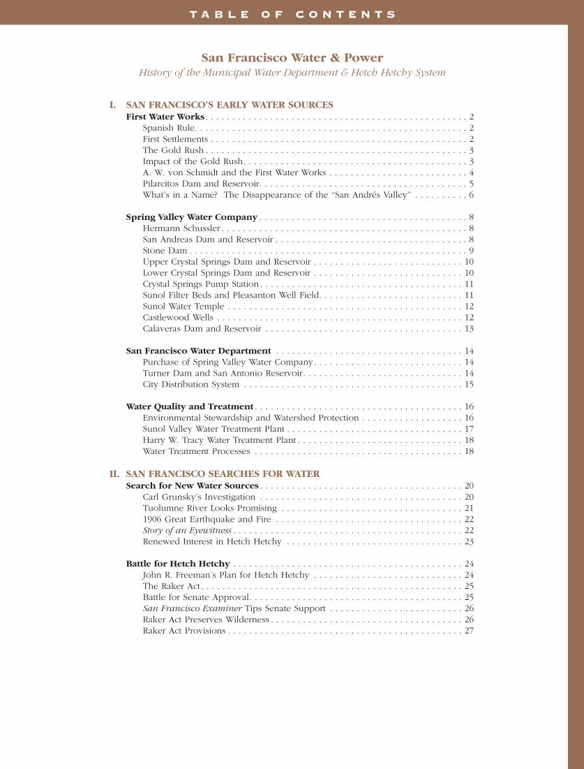
Development began in June 1870, and Lock’s Creek Tunnel, now StoneDam Tunnel No. 1, was drifted fromPilarcitos Creek through Cahill Ridge to San Mateo Creek. Flumes were constructed from Lock’s, Apanolio and Corinda Los Trancos Creeks to the tunnel. The Lock’s Creek Line wasthe result, and instead of flowing to the ocean, the water from these creeks was diverted to San Andreas Reservoir,about fifteen miles northeast.
Pilarcitos Creek rises on the easternside of Montara Mountain and flowsthrough a narrow gap in the range to the west. Upper Pilarcitos Creek is intercepted by Pilarcitos Dam, but the watershed below the dam is alsoextremely productive.
To exploit this lower watershed, theStone Dam diversion was placed in the deep narrow canyon about twomiles south of Pilarcitos Dam. In 1871, a flume 4,500 feet long was built south from the dam to carry thelower Pilarcitos water to Lock’s CreekTunnel, where it was added to theflow to San Andreas Reservoir.
Stone Dam is constructed of rubblemasonry, granite blocks quarried belowthe dam site, and topped with a brickcoping, laid herring-bone fashion. It isa thin-arch dam, the pioneer exampleof this construction method. The smallreservoir has a capacity of five milliongallons (15.4 acre feet).
The Lock’s Creek development pro-duced two million gallons of water perday. Its use was discontinued in 1898,but the Stone Dam diversion remainsin use today.
Lower Pilarcitos Creek’s flow is nowdiverted through the Stone Dam tunneland concrete pipes into San MateoCreek and Lower Crystal SpringsReservoir. The Coastside County WaterDistrict, which serves Half Moon Bayand other seaside communities, takesdelivery of up to 2.5 million gallonsper day of raw water supplies fromPilarcitos Reservoir by gravity.
San Francisco Water and Power 9
Workers drill Lock’s Creek Tunnel 1870

UPPER CRYSTAL SPRINGS DAM AND RESERVOIR
Built in 1876 of earth with a puddled-clay core, Upper Crystal Springs Damis 520 feet long and 70 feet high, sepa-rating the upper and lower CrystalSprings lakes three miles from thesouthern end. Since 1923, the dam hassupported the roadbed for the statehighway to Half Moon Bay.
The first outlet for Upper CrystalSprings Reservoir was a brick-lined,horseshoe-shaped tunnel, six feet high,five-and-a-half feet wide and 775 feetlong on the east side of the dam. A 90-foot-deep, brick-lined shaft at mid-tun-nel gave access to a 42-inch regulatinggate to control water from the reser-voir.
In 1885, a 42-inch pipe was laid in thetunnel from the regulating gate beyond
the outside portal of the outlet tunnel.To keep its crest above the water andaccommodate the relocated stageroadbed to Spanish Town (Half MoonBay), Upper Crystal Springs Dam wasraised in 1891 by an earth fill. Theoriginal outlet tunnel was broken dur-ing the 1906 earthquake, some 20 feetof the line fractured by a lateral earthmovement of five-and-a-half feet. Theearthquake damage was ultimatelyrepaired and on August 28, 1924, theoriginal tunnel was restored to providefree, unregulated flow between theUpper and Lower Crystal SpringsReservoirs.
LOWER CRYSTAL SPRINGS DAM AND RESERVOIR
The newer Lower Crystal Springs Dam,on San Mateo Creek below the junctionof its main branches, was built bySchussler in 1888. It was raised a fewfeet in 1890, and again in 1911 to itspresent height of 154 feet. It is 176 feetwide at the base and 600 feet long atthe crest. A full gravity type, the archeddam is built up of interlocking concreteblocks formed and poured in place.The design permits a future increase in height of 45 feet. Two outlet towerswere constructed near the dam, one in 1891 and the other 40 years later.Although the fault line of the SanAndreas Rift is only 400 feet west ofthe site, the concrete dam showed nodamage from the 1906 earthquake orthe 1989 Loma Prieta quake.
With a 35-square-mile catchment area,Lower Crystal Springs Dam impounds22.6 billion gallons of water (69,380acre feet), forming a lake nine mileslong, one mile wide at its widest andabout 122 feet deep at its deepest. Thelake has a surface area of 1,492 acres
10 San Francisco Water and Power
Spring Valley Water Company Directors 1890
Lower Crystal Springs Dam under construction 1887

and covers portions of the earlySpanish grant ranchos of Cañada deRaymundo, de las Pulgas, Feliz andSan Mateo.
Lower Crystal Springs Reservoir wascelebrated in October 1934 as the finaldestination of San Francisco’s watersupplies from Hetch Hetchy Reservoir,which traveled more than 160 milesacross California from its source in theSierra Nevada to the Peninsula. Stilltoday, the reservoir impounds HetchHetchy water supplies intended forfuture delivery to Peninsula and SanFrancisco customers.
In 1976, the American Society of CivilEngineers designated Lower CrystalSprings Dam as a California HistoricCivil Engineering landmark. During itsconstruction, Hermann Schusslerinvented a number of constructiontechniques used to this day, such aswashing aggregate, machine mixing ofconcrete, roughening existing surfacesto ensure adhesion, curing by coveringand wetting, and staggered joints.Spring Valley installed a bronze plaqueat the dam commemorating Schussler,by translating and inscribing the epi-taph of Sir Christopher Wren in SaintPaul’s Cathedral in London, “Si
Monumentum Requiris, Circumspice”(“If you seek his monument, lookabout you”).
Fred C. Herrman was appointed thechief engineer of Spring Valley in 1911.He relinquished the position in 1914,engaging in general practice as a con-sulting engineer and rendering valuableservice to Spring Valley during the RateCase of 1915-1917.
George A. Elliott was appointed thechief engineer in 1914. He remained inthat position until the municipal take-over of Spring Valley by San Franciscoon March 3, 1930.
In 1967, the State of California wasplanning to lay a 4.2-mile section ofthe Junipero Serra Freeway (I-280),then under construction, along theshore of Crystal Springs Lake. SanFrancisco invoked a federal law, andobtained assistance from the U.S.Department of Interior, which has avoice in the use of federal highwayfunds, to force the relocation of thefreeway to its current alignment along
the crest of Pulgas Ridge. In spite of itsrelocation, the freeway offers some ofthe most beautiful views of California’scoastal woodlands on the West Coast.
CRYSTAL SPRINGS PUMPSTATION
Crystal Springs Pump Station lies at the foot of Lower Crystal Springs Dam.Built in the late 1880s together with thedam and its outlet works, the pumpstation was designed to boost CrystalSprings water at low reservoir levels tothe higher grade line of San AndreasReservoir and for delivery to UniversityMound Reservoir in southeastern SanFrancisco. Originally rated at 25 mil-lion gallons per day, the pump stationwas upgraded in 1933 and 1949 topump a maximum of 70 million gallonsper day to San Andreas Reservoir.
SUNOL FILTER BEDS ANDPLEASANTON WELL FIELD
Along with its development of water sources on the San FranciscoPeninsula, the Spring Valley WaterWorks turned its attention to watersources across the bay in AlamedaCounty. Land was bought in Calaveras
Valley, fed by streams from MountHamilton. Spring Valley also acquiredthe Vallejo Mills properties near Niles,consisting of a dam, brick flume andmill constructed in the 1840s by DonJose de Jesus Vallejo, a brother ofGeneral Mariano Guadalupe Vallejo.These properties afforded excellentlocations for new reservoirs to servethe increasing demands of SpringValley Water Work’s customers.
Sunol Valley is a gravel-filled depres-sion of about 1,300 acres at the upperentrance to Niles Canyon in AlamedaCounty. The entire Alameda Creekdrainage of some 630 square milesflows through this area and isrestrained at the canyon entrance. TheFilter Beds were completed along withthe Sunol Aqueduct in 1900. SunolDam, a concrete structure 31 feet high,backs up the creek drainage to saturatethe gravel beds. The groundwater percolating through the gravel beds iscollected through a concrete tunnel, orfilter gallery, 8,985 feet long, piercedwith screened brass pipes and tappedby 38-inch perforated concrete pipes.Dependable yield is five million gallonsdaily, but under flood conditions, thegalleries will produce up to 20 milliongallons of water per day.
San Francisco Water and Power 11
Lower Crystal Springs Dam with Crystal Springs Pump Station at its base 1938

Some years after the Hetch HetchyAqueduct was completed, in 1948 SanFrancisco placed Irvington PumpStation in service. The pump stationwas designed to transport water underpressure from the Sunol Aqueduct toHetch Hetchy’s Bay Division pipelines,but is no longer in service. SunolValley groundwater is still collectedand may be pumped to San AntonioReservoir or the Sunol Valley WaterTreatment Plant.
Spring Valley held extensive artesianlands in the Livermore Valley, a naturalbasin tapped by 100 wells into thedeep gravel bed, which ranges indepth from 200 to 750 feet. SpringValley’s Chief Engineer Schussler decid-ed that these gravel beds, like those ofSunol Valley, were good water sources.He started drilling the wells in 1898.In 1909, a 30-inch pipe was installed totransmit the water from Pleasanton toSunol.
Spring Valley’s water exports from thePleasanton Well Field later drew thewater table of the Livermore Valley to an undesirable low level, affectingthe rights of other overlying landown-ers in the valley. Since 1949, the San Francisco Water Department has stopped exporting groundwaterfrom the valley. But the water is still
pumped for local use by the City of Pleasanton and Alameda County Water Conservation and Flood ControlDistrict, Zone 7.
SUNOL WATER TEMPLE
The Spring Valley Water Company builtthe Sunol Water Temple in 1910 tomark the confluence of its three EastBay water sources - Alameda Creek,the Sunol filter galleries and Pleasantonartesian well field. Designed byrenowned San Francisco architect Willis
Polk, the temple is an elegant, circularpavilion of twelve fluted columns sur-mounted by a peaked clay tile roofand copper finial of three dolphins tailto tail. It is modeled after the Templeof Vesta in Tivoli Gardens, built in the2nd century B.C. atop a cascade ofwaters from the Apennine Mountainscaptured from afar and sent via aque-duct to supply the homes and bath-houses of ancient Rome. The templefrieze quotes Isaiah 41:18: “I will makethe wilderness a pool of water and thedry lands springs of water. The streamswhereof shall make glad the city.”
Seriously damaged in the Loma Prietaearthquake of 1989, Sunol WaterTemple was beautifully restored in2001 with support from an active com-munity organization, Save Our Sunol.The restoration won the prestigious2001 Preservation Design Award fromthe California Preservation Foundation.
CASTLEWOOD WELLS
Castlewood, a small town just south ofPleasanton in the East Bay, receives afree water supply of 90 million gallonsper day in perpetuity from SanFrancisco, under an agreement reachedin the 1890s with Phoebe AppersonHearst. Phoebe’s late husband GeorgeHearst, a prominent local businessman,owned major interests in the Comstock,Homestake and Anaconda mines, the
12 San Francisco Water and Power
Sunol Filter Galleries 1906
Sunol Water Temple
largest silver and copper mines inAmerica’s history, as well as one of San Francisco’s hometown newspapers,the Examiner. Castlewood continuedto receive water from groundwaterwells in the fertile valley.
CALAVERAS DAM ANDRESERVOIR
In 1877, San Franciscans were stilluneasy and questioning the adequacyof their water supply. Despite theincreasing volumes of water beingbrought into the city by Spring ValleyWater Works, there never was reallyenough, and memories were fresh ofthe numerous fires that had devastatedthe young city. The Board ofSupervisors frequently used waterrates, which they controlled, as elec-tion issues. Spring Valley owners, ques-tioning the adequacy of these rates,showed reluctance to invest capital indeveloping additional water sources.San Franciscans again started talkingabout building their own water system.
A special study committee, headed byCity Engineer T. R. Scowden, recom-mended on April 19, 1875 that SanFrancisco buy a reservoir site on theborder of Alameda and Santa ClaraCounties, as the beginning of a futuremunicipal water supply. The city wasunable to act quickly and Spring Valleyeffectively blocked this threat of com-petition by promptly purchasing theland and water rights for itself.
The site is well situated to impoundwater from a number of streams flow-ing down the gorges of the CoastRange into Alameda Creek and theSunol Valley. Two of these streams,Smith and Isabel Creeks, after circlingMount Hamilton, unite to form theArroyo Hondo which flows throughCalaveras Valley.
Construction of the hydraulic fill damdid not start for another 38 years, until1913. At that point, the Spring ValleyWater Company had purchased theSpring Valley Water Works. A series ofmisfortunes and engineering errors cul-minated in a failure of the partiallycompleted dam on March 24, 1918,when the upstream face of the dam
sloughed off and the water gate towercollapsed. The engineering diagnosiswas that the hydraulic fill had beenimproperly compacted, leaving voids inthe center of the dam. San FranciscoCity Engineer Michael O’Shaughnessy,foreseeing San Francisco’s future pur-chase of Spring Valley’s assets, turnedhis attention to the Calaveras construc-tion. Unofficially, he kept “a watchfuleye on this proposition so that the citywill not inherit a ‘gold brick’ if itshould take this property over.”
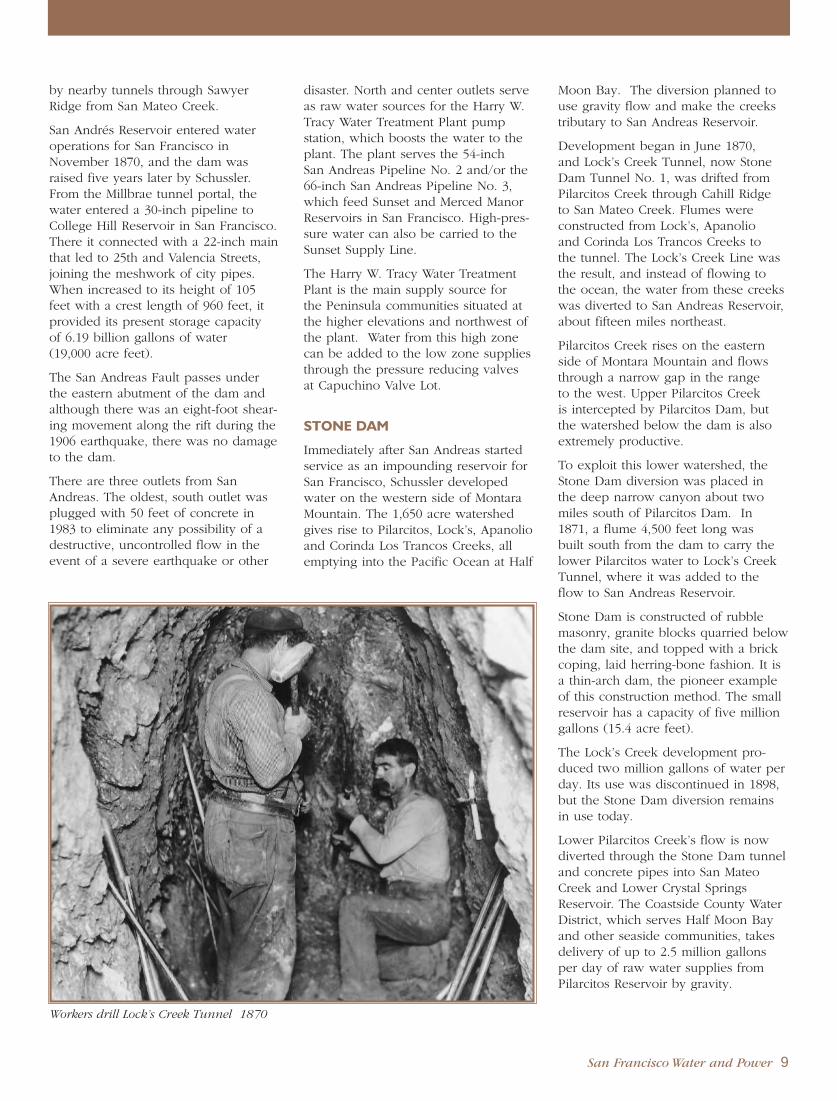
The dam was completed in 1925. At230 feet high at the crest, it was thehighest earth-fill dam in the world,impounding 31.55 billion gallons(96,860 acre feet). The lower portionis built up by hydraulic fill method andthe upper part with a rolled clay coresupported on either side by looselydumped material containing a largeproportion of rock. The dam is 1,200feet long and 1,500 feet wide at thebase. The dam was strengthened in1975 to meet then current earthquakestandards -- a $1.6 million project ofthe 1972 water bond program.
The first significant East Bay additionto San Francisco’s local water supplysystem, Calaveras Reservoir has awatershed area of 101 square milesflowing into Calaveras Creek andArroyo Hondo, and 35 square milesflowing into Upper Alameda Creek, for a total of 136 square miles.
In 1925, water from CalaverasReservoir was delivered to neighboringcustomers via a network of distributionpipelines, and to San Francisco throughthe Niles Canyon Aqueduct and submarine pipelines under SanFrancisco Bay to Spring Valley WaterCompany’s Peninsula transmission sys-tem. Since 1966, Calaveras Reservoirwater is filtered at the Sunol ValleyWater Treatment Plant prior to enteringthe Hetch Hetchy Aqueduct at theAlameda Siphons.
In 1931, the Upper Alameda CreekDiversion Tunnel was completed fromUpper Alameda Creek to CalaverasReservoir, as planned by the SpringValley Water Company. The tunnelincreased available watershed suppliesto fill Calaveras Reservoir.
In 2001, the San Francisco PublicUtilities Commission initiated a study of the seismic safety of Calaveras Dam,given increasing industry-wide con-cerns about the fitness of hydraulic filldams and the dam’s proximity to theCalaveras Fault. Calaveras Reservoirwater levels have been lowered to protect the dam at the direction of the California Department of Safety of Dams, and a reconstruction projectis under way to replace it.
San Francisco Water and Power 13
Calaveras Dam and outlet tower 1926

S A N F R A N C I S C O W A T E R D E P A R T M E N T
Municipal efforts to buy out theSpring Valley Water Companyhad been a source of constant
controversy from as early as 1873,when San Francisco’s first attempt topurchase it was turned down by thevoters because the price was too high.The voters usually found the sale priceoffered by Spring Valley to be higherthan they were willing to pay.
PURCHASE OF SPRINGVALLEY WATER COMPANY
A half-century of farsighted leadershipby a succession of mayors and engi-neers finally paid off on March 3, 1930,when San Francisco purchased theSpring Valley Water Company for$39,962,606.51, creating the SanFrancisco Water Department under theBoard of Public Works. Nelson A.Eckart, Hetch Hetchy Chief AssistantEngineer under City EngineerO’Shaughnessy, was named the firstGeneral Manager and Chief Engineer ofthe newly acquired waterworks.
At the time of the takeover, the SpringValley Water Company’s assets wereconsiderable, including Pilarcitos, SanAndreas and Crystal Springs Dams andReservoirs on the Peninsula; CalaverasDam and Reservoir, Sunol FilterGalleries and Pleasanton Well Fields in the Sunol Valley, Niles CanyonAqueduct, transmission pipelines,pump stations and tunnels in the SouthBay and Peninsula, as well as thereservoirs, pump stations and distribu-
tion pipelines that served the City ofSan Francisco. Spring Valley alsoturned over their riparian water rightsand rights-of-way necessary to protect,divert and use their water supplies andfacilities. In 1934, the Hetch HetchyAqueduct was completed and SierraNevada mountain water supplies wereavailable to integrate with the SanFrancisco’s lately - acquired municipalwater system.
TURNER DAM AND SANANTONIO RESERVOIR
The latest addition to the AlamedaDivision’s water supply, Turner Damand San Antonio Reservoir, was com-pleted by the San Francisco WaterDepartment in 1965 at a cost of $9.4million, which included the dam, outletworks, spillway and related equipmentand accessories. The dam is named forJames H. Turner, former GeneralManager and Chief Engineer of HetchHetchy, and former General Managerof Public Utilities for San Francisco.
Originally sited by the Spring ValleyWater Works in 1875 and mentioned inthe 1912 Freeman Report to providestorage adjacent to the Hetch HetchyAqueduct, the reservoir is situated onLa Costa (San Antonio) Creek, a tribu-tary of Alameda Creek about threemiles southeast of Sunol. The reservoirimpounds 16.5 billion gallons of water(50,650 acre feet), the runoff from a40-square mile watershed yielding over1.7 billion gallons of water annually.Additionally, the reservoir can providestorage for water from Hetch Hetchyand other sources to meet high period-
14 San Francisco Water and Power
Lower Crystal Springs Dam outlet works under construction 1888
San Francisco purchases Spring Valley Water Company, City Hall 1930
(Michael O’Shaughnessy at far left)

ic demands in the South Bay Area andassure water service during possibleinterruptions of Hetch Hetchy supply.
Turner Dam is a compacted, earth-fillstructure 195 feet high, 2,160 feet longand 1,075 feet wide at the base. Aswith Calaveras supplies, water fromSan Antonio Reservoir is sent to theSunol Valley Water Treatment Plant forfiltration before entering the HetchHetchy Aqueduct at the Alameda Creeksiphons.
CITY DISTRIBUTION SYSTEM
Having its origins in the first pipelineslaid in 1857 by the San Francisco CityWater Works (Bensley Company) fromthe Lombard and Francisco Reservoirs,and in the early system George Ensigninstalled at Spring Valley in 1858, SanFrancisco’s complete water distributionsystem has grown over the past 125years into a dozen reservoirs and auxil-iary tanks at various elevations, pump-ing stations, and an amazing networkof 1,191 miles of pipeline of variousdiameters all tucked out of view underthe city streets.
Built on hills, San Francisco’s geogra-phy ranges in elevation from sea levelto 900 feet. Totally urbanized withhomes at the highest elevations, thehills posed challenges and complicatedhydraulic situations for water engi-neers. Their genius created a series ofdifferent pressure districts, which incor-porate the oldest water works, reser-voirs and pipelines with the newestadditions and improvements into amodern, efficient, and integrated waterdistribution service.
Local water produced from Bay Areasources together with Hetch Hetchywater from the High Sierra is deliveredinto the City, mostly by gravity flow,through four Peninsula transmissionmains: San Andreas No. 2, CrystalSprings No. 2, Sunset Supply Line, andBaden-Merced, each discharging intoone or more of three terminal distribu-tion reservoirs. From these reservoirs,the water is gravity fed or pumped intoeight covered distribution reservoirs, atelevations of 135 to 800 feet, andsmaller storage tanks, strategically sited
at elevations of 370 to 900 feet. Theindividual pressure districts beingserved vary greatly in area and canusually be supplied by more than oneof these sources.
San Francisco’s municipal storage reser-voirs can hold at capacity nearly 416million gallons, about a five-day supplyfor the city. In addition, there is anemergency supply immediately avail-able within the city at Lake Merced and Laguna Honda which togetherhold 2.6 billion gallons. In order oftheir size, the reservoirs are ranked bytheir capacities in millions of gallons:
Lake Merced* 2,565.0Sunset** 176.7University Mound** 140.9Laguna Honda* 44.0Sutro 31.4College Hill 14.1Summit 14.0Stanford Heights 12.9Merced Manor** 9.5McLaren Park Tanks 8.0Lombard 6.0Hunter’s Point 1.1Potrero 1.0
* Emergency supply
** Terminal reservoirs for regionalwater supplies, shared in emer-gencies by San Francisco and itssuburban wholesale water cus-tomers in the Bay Area WaterSupply and Conservation Agency.
Due to its age and deteriorating condi-tion, Lombard Reservoir was recentlyreplaced with a larger reservoir, nowfilled with other sources of water fromSan Francisco’s water system.
Francisco Reservoir, built before theCivil War with a capacity of 2.5 milliongallons, is no longer in service.
The underground transmission and dis-tribution mains, ranging in size fromtwo inches to 60 inches in diameter aremaintained and operated by the CityDistribution Division. Water delivery is monitored to 170,000 services, someof which require as many as a dozenwater meters. Along with the ongoingprogram of repair and annual replace-ment of nearly 10 miles of deterioratedpipes, worn meters are replaced at therate of some 6,800 per year.
San Francisco Water and Power 15
Black Point Flume and Pump Station, Lombard St. Hill circa 1900

San Francisco water supply is keptclean and clear, even during timesof heavy rainfall and ground ero-
sion, because a great deal of effort isexpended throughout the water supplysystem by skilled water quality profes-sionals. Housed in modern facilitiesand laboratories in Millbrae andBurlingame, Water Quality Bureau staff monitor and control water qualityand treatment to meet increasingly strigent state and federal requirementsand regular monitoring by theCalifornia Department of HealthServices.
San Francisco’s water quality goals and standards are high - no water-borne disease has ever been traced to its local Bay Area or Hetch Hetchysupplies.
San Francisco protects its water sourcesfrom pollution. Hetch Hetchy sourcesin the Sierra Nevada were originallyrelatively secure from sources of con-tamination. However, increased recre-ational use of the watersheds byequestrians, hikers and backpackersnow require strict sanitary controls tobe enforced throughout these areas.
The system-wide sampling and testingresponsibilities of the Water QualityBureau range from Hetch Hetchy’shighest elevations to the complexitiesof the City Distribution System. WaterQuality staff operate stations along theaqueduct and distribution lines for limetreatment, fluoridation and chloramina-tion. At the Rock River Treatment Plant,calcium oxide (CaO) is added to the
Hetch Hetchy water. The calcium oxideis slaked by water to form calciumhydroxide (Ca(OH)2), resulting inwater more alkaline on the pH scale toinhibit its corrosive action on pipelines,storage tanks and household plumbing.
Waters delivered to San Francisco andconsumers north of Crystal Springshave been fluoridated since 1952, inaccordance with a program mandatedby the voters in 1951. Fluoridationresults in a significant reduction in the incidence of dental decay for SanFrancisco children. Construction of anew fluoridation facility in the East Bayis under way to provide system-widefluoridation by the end of 2005.
ENVIRONMENTAL STEWARDSHIPAND WATERSHED PROTECTION
A watershed is a basin bound byridges, such as hills or mountains, thatcollects rainfall and snowmelt flowingdownhill in the streams, rivers andlakes in the valley below. Watershedscreate links between everything thatlives or lies within them. What hap-pens upstream affects the quality of thenatural environment of the plants, ani-mals and people that live downstream,and the health of the watershed influ-ences the quality of the water that iseventually collected for drinking water.
San Francisco protects the naturalresources entrusted to its care, andcontinuously monitors the health andcondition of its watersheds to ensurehigh source water quality and preserve
valuable habitat for the creatures wholive there. Watershed protectionincludes managing land use; monitor-ing rare and endangered species ofplants, animals, birds and fish; control-ling erosion; preventing wild fires; andproviding public access that protectsenvironmental values while providingrecreation opportunities for respitefrom urbanization.
In the San Francisco Bay Area, thereare two watersheds that contribute tothe total water supply of the system:the Peninsula and Alameda CreekWatersheds. The Peninsula Watershedencompasses 23,000 acres surroundingthree drinking water storage reservoirs,Crystal Springs, San Andreas andPilarcitos. A unique natural resourcelocated adjacent to the highly urban-ized communities of San MateoCounty, the watershed hosts a varietyof habitats and supports the highestconcentration of rare, threatened andendangered species in the entire nine-county region. The PeninsulaWatershed is part of the CentralCalifornia Coastal Biosphere Reserveand has been designated by Californiaas a Fish and Game Refuge.
The Spring Valley Water Company purchased the lands, farms and wood-lands surrounding likely reservoir siteson the San Francisco Bay Peninsula inthe late 1800’s, ensuring a secure watersupply for San Francisco and preserv-ing valuable natural resources for thefuture. San Francisco’s purchase ofSpring Valley’s assets in 1930 entrusted
16 San Francisco Water and Power
W A T E R Q U A L I T Y A N D T R E A T M E N T
San Andreas Reservoir (foreground) looking east to San Francisco Bay

the city with the future care and pro-tection of this watershed.
In 1969, easement agreements weremade between the federal and stategovernments and with San Franciscoand San Mateo County to preserve thePeninsula Watershed for water supplyand open space purposes. The agree-ments limit the uses of 19,000 acres,including Upper and Lower CrystalSprings Reservoirs, San Andreas Lakeand watershed lands east of MontaraMountain for purposes of water supplyand ecological preservation. A scenicand recreational easement covers the4,000 acres in the southeast sectionbetween the lakes and Pulgas Ridge.The Golden Gate National RecreationArea administers these easements forthe federal government. The water-shed had been protected from publicaccess until recently, when a 10-milestretch of trail along the ridgeline wasopened to hikers, cyclists and equestri-ans for guided tours.
In contrast, San Francisco owns onlyone-third, or 36,000 acres, of the south-ern Alameda Creek Watershed. Thiswatershed consists of rolling grasslandsand native oak woodlands in the EastBay. Like the Peninsula Watershed, ithas been protected since the mid-1800s. However, it has been leased forgrazing, nursery and quarry operations.The drainage area of this watershed isfar greater than the area San Franciscoowns, so the city has less control overthe quality of the water in the streamsand creeks that feed Calaveras and SanAntonio Reservoirs. Here, land uses,urban encroachment, recreation andother activities could adversely affectwater quality. But Alameda Countyplanners have joined with the lovers of open space to maintain a wildernessenvironment close to major populationareas that also serves as a nesting habitat for golden eagles in AlamedaCounty.
Within the highly urbanized neighbor-hoods of San Francisco, some watersystem facilities provide recreationalopportunities to city dwellers.Reservoir roofs and other propertiesprovide public facilities operated bythe San Francisco Recreation and ParkCommission, including tennis courts,
parks, playgrounds, golf courses and neighborhood green space. Theaward-winning demonstration Gardenfor the Environment at Seventh Avenueat Lawton was developed in 1991 incooperation with the San FranciscoLeague of Urban Gardeners, the CityRecycling Program, the Recreation andPark Department and many other civicgroups, to provide hands-on work-shops on low-water-use landscaping.
In the Sierra Nevada, San Francisco’spreservation and maintenance of hikingtrails in the Hetch Hetchy watershedhave resulted in thousands of back-packers and hikers preferring the scenic Grand Canyon of the Tuolumneto the overdeveloped and overcrowdedYosemite Valley. The city also fundsNational Park Service backcountrypatrols and educational programs to minimize human impacts on thefragile wilderness.
Because of its effective watershed management policies in the SierraNevada and responsible recreationaluse in its watershed, San Francisco’sHetch Hetchy water supply is exemptfrom filtration requirements set by the U. S. Environmental ProtectionAgency and the California Departmentof Health Services.
San Francisco’s environmental steward-ship not only protects the high qualityof its drinking water sources in boththe Sierra Nevada and the Bay Area,
but also preserves areas rich in naturalaesthetics and biodiversity for the ben-efit of travelers, leisure recreationists,educators, scientists and environmen-talists. The character of these areas are a treasured heritage for future generations to enjoy.
SUNOL VALLEY WATERTREATMENT PLANT
Activated at its dedication onSeptember 14, 1966 by Mayor John F. Shelley, Governor Edmund G.“Pat” Brown and Interior SecretaryStewart Udall, the Sunol Valley WaterTreatment Plant was San Francisco’sfirst filtration installation resulting from the nation’s drive for clean water.
Constructed at a final cost of $10.5 million, the plant filters water fromCalaveras Reservoir, five miles to thesouth, San Antonio Reservoir to thenorth, and the nearby Sunol under-ground sources. It has the added capa-bility of filtering up to 80 million gal-lons per day (MGD) from the HetchHetchy Aqueduct. The plant’s originaldesign capacity of 80 MGD wasexpanded in 1976 to 160 MGD.
The filtration plant was financed fromwater rate revenues that serviced the$115 million bond issue approved bySan Francisco voters in 1961.
Using $47 million in revenue bondfunds approved by San Francisco vot-
San Francisco Water and Power 17
Sunol Valley Water Treatment Plant

ers in 1984, the Sunol Plant wasupgraded in 2002 to include new state-of-the-art sedimentation and back-washwater systems, chemical feed systemsand water quality laboratory facilities,seismic upgrades and renovated build-ing systems. There are plans for futureupgrades to provide treated water stor-age, install pre-treatment disinfectionfacilities, and expand the capacity ofthe plant.
The old Calaveras Pipeline from thereservoir to the treatment plant wasreplaced in 1991 along a similar alignment.
HARRY W. TRACY WATERTREATMENT PLANT
The Harry W. Tracy Water TreatmentPlant is a key element in the Peninsulasupply system, filtering water from SanAndreas Reservoir for delivery to con-sumers on the San Francisco Peninsula.The plant, formerly known as the SanAndreas Water Treatment Plant, wasbuilt at a cost of $7.6 million, and start-ed operation on August 8, 1972 withan original capacity of 80 MGD. Theplant was expanded in 1992 to providea combined treatment capacity of 160MGD. The $55 million improvementsinstalled ozone pretreatment to providemore effective disinfection, and builtnew filtration units to meet Peninsulawater needs through the year 2030.
In early 1994, the expanded plant wasdedicated in a special ceremony and
renamed in honor of longtime WaterQuality Manager Harry W. Tracy. Tracywas a lifelong employee, serving from1937 until his death in 1985. As WaterQuality Bureau Manager, he led theCity’s and water industry’s efforts toprevent contamination of water sup-plies through watershed protection.Tracy also led efforts to certify watertreatment plant operators to assure that water quality standards were met.
WATER TREATMENT PROCESSES
Water produced from San Francisco’slocal watersheds is treated by theSunol and Tracy Plants with processesof pretreatment, flash-mixing, acid/base(pH) adjustment, coagulation, floccula-tion, sedimentation, filtration and finaldisinfection.
As water enters the plants, severalchemicals essential to the treatmentprocess are added in proportion to the flow and thoroughly flash-mixed.These chemicals include chloramine or ozone for disinfection, alum or polyelectrolyte for coagulation, liquidfluoride to aid in the control of toothdecay, and coagulant aids as necessaryto assist in the flocculation process.
The alum or polyelectrolyte added in the flash-mixing forms a white mineral precipitate that coagulates intosnowflake-like particles of silt, clay,bacteria and other foreign matter.Coagulant aids are added to assist theformation of strong, heavy flocculent
particles which settle out quickly during the sedimentation process.
Sedimentation basins accept waterdirectly from the flocculation basins.The water remains in sedimentation fora couple of hours. This is where theflocculent particles settle to the bottomas sludge, carrying with them anyimpurities. The sludge is removed fromthe basins by a scraper and depositedinto trenches. Sludge is directed to set-tling, or sludge, basins.
From the sedimentation basins, settledwater moves to filters where it flowsdown through a bed of gradedanthracite coal underlain by a bed offine sand. The filters remove the lastparticles of sediment and foreign mat-ter, producing a sparkling clear waterfree of turbidity and bacteria. Beforethey start to clog and lose efficiency,filters are automatically flushed cleanof trapped material by back-washingwith clean water.
The final step in the treatment processis a controlled dosage of chloraminejust sufficient to ensure absolute safetyof the water for home use. At the sametime, caustic soda is added to make thewater less corrosive to metal pipelinesand home plumbing. Final chemicaladditions help to ensure the water willbe delivered to home consumers withthe same high quality it has when itleaves the filtration plant.
In 2004, San Francisco changed itsresidual disinfectant from chlorine tochloramine to reduce formation of dis-infection byproducts, which may beharmful. New chloramination facilitieswere built at San Antonio Pump Stationin Sunol and the Harry Tracy Plant to add chloramine before delivery tocustomers.
18 San Francisco Water and Power
Harry W. Tracy Water Treatment Plant aerial view

SAN FRANCISCO
SEARCHES FOR WATER

When A. W. von Schmidt leftthe Spring Valley Water Worksin 1864, he went on to gener-
al civil engineering practice. His mostnotable achievement in San Franciscowas the successful destruction ofBlossom Rock, a navigation hazard inthe Bay some one-half mile northeastof Pier 39. A later and lesser knownenterprise was Schmidt’s effort to tapthe Sierra Nevada watersheds, not somuch for San Francisco, although thecity would have benefited fromSchmidt's success, but rather to irrigateboth the Nevada Desert and theCalifornia Central Valley. Achievingonly limited success and later formingthe Bay Cities Water Company toexploit the Sacramento and AmericanRivers, Schmidt blazed a trail to theSierra Nevada for others who laterlooked to the mountains for SanFrancisco’s water.
In May 1882, J.P. Dart, an engineer forthe San Francisco and Tuolumne WaterCompany, proposed a route for bring-ing water from the Tuolumne River,upstream from Jacksonville, to SanFrancisco. In 1888, George M. Harris
pointed out the possibility of the HetchHetchy Valley and Tuolumne Riverwater supply to Mayor E. P. Bond,offering to sell his rights to the entirelength of the Tuolumne for $220,000.John Henry Quinton, a Los Angelesengineer, investigated Hetch Hetchyand the Tuolumne, reporting to theU.S. Geological Survey in 1891. TheU.S. Geological Survey Annual Report1899-1900 included a study recom-mending Hetch Hetchy as an adequatewater source for San Francisco.
These were some of the numerousinvestigations and studies into addition-al sources of clean drinking water forSan Francisco. Farsighted civic leadersbegan to realize that the only satisfac-tory solution to the problem wasmunicipal ownership of assured watersources. However, the Spring ValleyWater Company owned or controlledall local Bay Area water sources as faraway as the Coast Range in AlamedaCounty. The decision was made - SanFrancisco must look beyond the CoastRange for a future water supply, to theSierra Nevada along California’s easternborder.
For a city with a population of lessthan 350,000 at the time, supported by only a few scattered communitiesaround the Bay, this was a tremendouschallenge. From the city it is 50 milesacross the Coast Range, another 50miles across the San Joaquin Valley,and still another 50 miles through thefoothills to the high Sierra Nevada, orjust about 150 miles! The situation andtask had to be met if the city and BayArea were to continue to grow.
CARL GRUNSKY’SINVESTIGATION
Mayor James Phelan directed CityEngineer Carl E. Grunsky to study 14 possible water sources during 1900 and 1901:
Spring Valley Water Works
San Joaquin River
Lake Tahoe
Clear Lake and Cache Creek
Yuba River
Stanislaus River
Feather River
Mokelumne River
American River
Tuolumne River
Sacramento River
Bay Shore Gravels
Eel River
Bay Cities Water Company
S E A R C H F O R N E W W A T E R S O U R C E S
Hetch Hetchy Valley 1918
20 San Francisco Water and Power
Carl Grunsky 1901
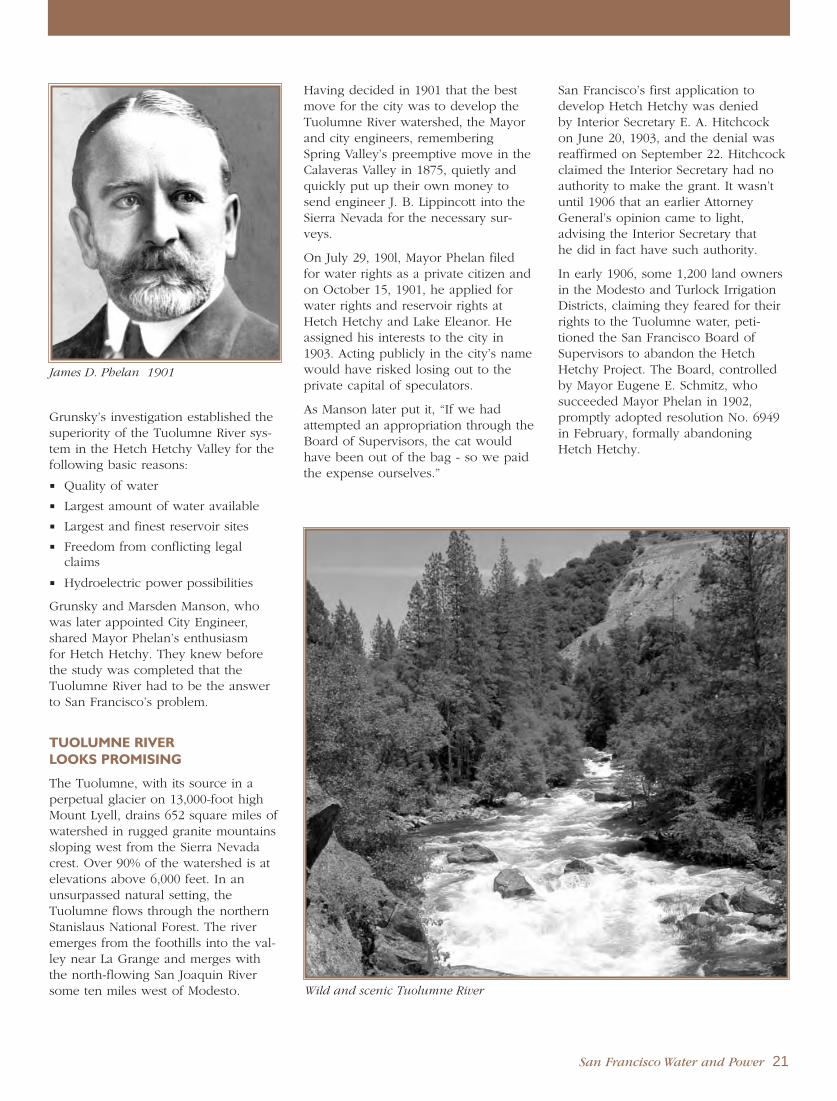
San Francisco Water and Power 21
Grunsky’s investigation established thesuperiority of the Tuolumne River sys-tem in the Hetch Hetchy Valley for thefollowing basic reasons:
Quality of water
Largest amount of water available
Largest and finest reservoir sites
Freedom from conflicting legalclaims
Hydroelectric power possibilities
Grunsky and Marsden Manson, whowas later appointed City Engineer,shared Mayor Phelan’s enthusiasm for Hetch Hetchy. They knew beforethe study was completed that theTuolumne River had to be the answerto San Francisco’s problem.
TUOLUMNE RIVERLOOKS PROMISING
The Tuolumne, with its source in aperpetual glacier on 13,000-foot highMount Lyell, drains 652 square miles ofwatershed in rugged granite mountainssloping west from the Sierra Nevadacrest. Over 90% of the watershed is atelevations above 6,000 feet. In anunsurpassed natural setting, theTuolumne flows through the northernStanislaus National Forest. The riveremerges from the foothills into the val-ley near La Grange and merges withthe north-flowing San Joaquin Riversome ten miles west of Modesto.
Having decided in 1901 that the bestmove for the city was to develop theTuolumne River watershed, the Mayorand city engineers, rememberingSpring Valley’s preemptive move in theCalaveras Valley in 1875, quietly andquickly put up their own money tosend engineer J. B. Lippincott into theSierra Nevada for the necessary sur-veys.
On July 29, 190l, Mayor Phelan filedfor water rights as a private citizen andon October 15, 1901, he applied forwater rights and reservoir rights atHetch Hetchy and Lake Eleanor. Heassigned his interests to the city in1903. Acting publicly in the city’s namewould have risked losing out to theprivate capital of speculators.
As Manson later put it, “If we hadattempted an appropriation through theBoard of Supervisors, the cat wouldhave been out of the bag - so we paidthe expense ourselves.”
San Francisco’s first application todevelop Hetch Hetchy was denied by Interior Secretary E. A. Hitchcockon June 20, 1903, and the denial wasreaffirmed on September 22. Hitchcockclaimed the Interior Secretary had noauthority to make the grant. It wasn’tuntil 1906 that an earlier AttorneyGeneral’s opinion came to light, advising the Interior Secretary that he did in fact have such authority.
In early 1906, some 1,200 land ownersin the Modesto and Turlock IrrigationDistricts, claiming they feared for theirrights to the Tuolumne water, peti-tioned the San Francisco Board ofSupervisors to abandon the HetchHetchy Project. The Board, controlledby Mayor Eugene E. Schmitz, who succeeded Mayor Phelan in 1902,promptly adopted resolution No. 6949in February, formally abandoningHetch Hetchy.
James D. Phelan 1901
Wild and scenic Tuolumne River

1906 GREAT EARTHQUAKE AND FIRE
The devastating earthquake of April 18,1906, and the failure of the water sys-tem to curtail widespread destructionby three days of fire following thegreat shake, refocused San Francisco’sattention on a secure, reliable watersource.
After news of the great earthquakereached them, Collier’s Weekly
telegraphed Jack London, the mostpopular American writer of his time, to write an eyewitness account.London, who with his wife Charmianrode on horseback forty miles fromtheir home in Glen Ellen to the city,described the scene vividly in his“Story of An Eyewitness” published on May 5, 1906, excerpted below.
Story of An Eyewitness
The earthquake shook down in San
Francisco hundreds of thousands of
dollars worth of walls and chimneys.
But the conflagration that followed
burned up hundreds of millions of
dollars’ worth of property. There is
no estimating within hundreds of
millions the actual damage wrought.
Not in history has a modern imperial
city been so completely destroyed.
San Francisco is gone. Nothing
remains of it but memories and a
fringe of dwelling-houses on its out-
skirts. Its industrial section is wiped
out. Its business section is wiped out.
Its social and residential section is
wiped out. The factories and ware-
houses, the great stores and newspa-
per buildings, the hotels and the
palaces of the nabobs, are all gone.
Remains only the fringe of dwelling
houses on the outskirts of what was
once San Francisco.
Within an hour after the earthquake
shock the smoke of San Francisco’s
burning was a lurid tower visible a
hundred miles away. And for three
days and nights this lurid tower
swayed in the sky, reddening the
sun, darkening the day, and filling
the land with smoke.
On Wednesday morning at a quarter
past five came the earthquake. A
minute later the flames were leaping
upward. In a dozen different quar-
ters south of Market Street, in the
working-class ghetto, and in the fac-
tories, fires started. There was no
opposing the flames. There was no
organization, no communication.
All the cunning adjustments of a
twentieth century city had been
smashed by the earthquake. The
streets were humped into ridges and
depressions, and piled with the
debris of fallen walls. The steel rails
were twisted into perpendicular and
horizontal angles. The telephone and
telegraph systems were disrupted.
And the great water-mains had
burst. All the shrewd contrivances
and safeguards of man had been
thrown out of gear by thirty seconds’
twitching of the earth-crust...
At nine o’clock Wednesday evening I
walked down through the very heart
of the city. I walked through miles
and miles of magnificent buildings
and towering skyscrapers. Here was
no fire. All was in perfect order. The
police patrolled the streets. Every
building had its watchman at the
door. And yet it was doomed, all of
it. There was no water. The dynamite
was giving out. And at right angles
two different conflagrations were
sweeping down upon it...
On July 21, 1906, the Board ofSupervisors received 11 new proposalsfor water sources. Mayor Schmitzappointed a panel of engineers on July 30 to study the proposals. Whenthe panel resigned without making a recommendation, rumors were rifethat the engineers would not put theirstamp of approval on the one sourcethat was apparently favored by theSchmitz administration.
22 San Francisco Water and Power
Aftermath of Great Earthquake and Fire 1906
Great Earthquake and Fire 1906

San Francisco Water and Power 23
Recommendation or no, the Board of Supervisors Committee on WaterSupply selected the Bay Cities WaterCompany proposal that the city buy itssystem for $10.5 million. Afterward, theBoard asked the city engineer to reporton the Bay Cities property, which hadits genesis in Schmidt’s early investiga-tions of the Sierra Nevada as a SanFrancisco water supply. Bay Citiesdepended on water from the southfork of the American River and thenorth fork of the Consumnes River.
This high-handed action was apparent-ly the last straw for financier RudolphSpreckels, San Francisco Bulletin
editor Fremont Older, former MayorPhelan and others. The Bay Cities dealwas just another in a long series ofcorruptions, but it infuriated advocatesof clean government and launched aseries of investigations into graft andcorruption, which came to trial in 1907and 1908.
San Francisco’s political boss, AbeRuef, crony and benefactor to MayorSchmitz, was sentenced to 14 years in the state penitentiary -- he actuallyserved five years in San Quentin.Mayor Schmitz, who had been a violin-ist and president of the Musicians’Union when Ruef gave him the politi-cal nod and blessing as Mayoral candi-date, was also convicted and sentencedto five years, but the Mayor’s convic-tion was reversed in appellate court.Before resigning, 16 members of theBoard of Supervisors testified for theprosecution.
Rebuilding from earthquake damage,investigations and trials delayed devel-opment of the city’s Hetch Hetchyinterests. Old, dim memories of the city in flames due to lack of waterwere now refreshed and brought intovivid, sharp focus.
RENEWED INTEREST INHETCH HETCHY
On April 22, 1908, Manson filed duplicates of the Phelan maps withSecretary Garfield, because the federalgovernment had returned the originalsin 1903 and they had been destroyedin the 1906 earthquake and fire. Hesigned these rights over to the city forone dollar.
During this time, the city again request-ed a permit from the Department ofthe Interior to build a water system inYosemite National Park. In July 1907,hearings on the request were held inSan Francisco before the Secretary ofthe Interior James Garfield. It was dur-ing these hearings and in briefs filedsubsequently with Garfield, that theModesto and Turlock Irrigation Districtsagreed with the city of San Franciscothat their share of the water would be
2,350 cubic feet per second, “off thetop, before the water became SanFrancisco’s supply.”
With a convicted Mayor, the officedevolved briefly upon SupervisorCharles Boxton, one of the 16 wholater resigned. Boxton was followed in the Mayor’s Office by Dr. EdwardRobeson Taylor and Patrick HenryMcCarthy. San Francisco was gettingready for James Rolph, Jr. to enter the scene in 1912.
Tuolumne River near its source

The long, hard fight to build adam and related installationswithin Yosemite National Park
was on. The Park was created byCongress on October 1, 1890, but atthe time it did not include YosemiteValley and Mariposa Grove.
Congress had given them to Californiafor park and recreation uses in the1864 Yosemite and Big Tree Grantssigned by President Lincoln. In 1906,the State ceded these properties backto the federal government and theywere added to Yosemite.
On May 11, 1908, after deliberating for ten months following the July 1906hearings, Interior Secretary Garfieldgranted limited permission for reser-voirs, dams, aqueducts and rights-of-way, with primary rights at LakeEleanor and secondary rights at Hetch Hetchy. The Taylor Board ofSupervisors accepted the GarfieldPermit and a $600,000 bond issue wasapproved on the June 4, 1908 ballot to purchase lands in and around LakeEleanor and Hetch Hetchy Valley. San Francisco voters gave a 20 to 1majority in 1910 to a $45 million bondissue to start construction of the Hetch Hetchy system.
The troubles began anew. Oppositioncropped up from four major sources:the private Spring Valley WaterCompany, the Turlock and ModestoIrrigation Districts, the National ParkService supported by vocal environ-mentalists, and the power promoters,including Sierra Ditch and WaterCompany, who had competing waterrights claims in the Lake Eleanor basinand additional claims in the CherryCreek basin.
A new Interior Secretary, Richard A.Ballinger, took office in Washington.On February 25, 1910, he issued SanFrancisco an order to show cause whythe section of the Garfield Permitapplying to Hetch Hetchy Valleyshould not be revoked. This wouldhave left the city with developmentrights only in the Cherry Creek Canyonand Eleanor Creek areas, clearly insuf-ficient for San Francisco’s needs.
Secretary Ballinger held hearings todiscuss his show-cause order and itwas from these hearings that the Boardof Army Engineers was born. On May10, 1910, Secretary Ballinger requestedthat the War Secretary appoint a Boardof Army Engineers to evaluate theHetch Hetchy proposal. The Board was also asked to compare the Hetch
Hetchy idea to a number of alterna-tives. In 1910 and 1912, the city negoti-ated for the purchase of the SierraDitch and Water Company’s holdingsin the Tuolumne Basin, and between1908 and 1911, San Francisco filed foradditional water rights in the TuolumneBasin.
JOHN R. FREEMAN’S PLANFOR HETCH HETCHY
During this period, the city hired John Ripley Freeman, a world-famoushydraulics engineer from Providence,Rhode Island, who was later tobecome an engineer for the New YorkBoard of Water Supply. In 1912, hepublished a preliminary design for theHetch Hetchy system, the FreemanPlan, which the Board of ArmyEngineers considered along withreports on alternative water supplies.
The eventual report of the Board onFebruary 19, 1913 supported theFreeman Plan and San Francisco’s con-tention that Hetch Hetchy Valley andReservoir be retained in the permit,largely because the alternative wouldhave been much more expensive andrequired the city to acquire water rightsin other basins. But it was now clear to
B A T T L E F O R H E T C H H E T C H Y
24 San Francisco Water and Power
Construction at O’Shaughnessy Dam (Michael O’Shaughnessy at far left) 1922

San Francisco Water and Power 25
all that a permit from the Secretary ofthe Interior would forever be subject tothe whims of succeeding administra-tions. The only reasonable relief avail-able to the city would be an outrightgrant of the necessary privileges fromthe Congress itself - enactment of aHetch Hetchy grant act.
THE RAKER ACT
Representative John Edward Raker ofManteca fired the first shot in Congressby introducing HR 112 on the floor ofthe House of Representatives on April7, 1913. That bill would not be passedby the House, nor would the threecompromise bills following: HR 4319on April 25, HR 6281 on June 23, andHR 6914 on July 18. In June of 1913,representatives of the city and theModesto and Turlock Irrigation Districtsmet in Washington D.C. to hammer outtheir differences. It was during thesemeetings that they came to a compro-mise regarding protection of districtwater rights that allowed for a 2,350 to4,000 cubic-feet-per-second system. Itwas HR 7207, introduced on August 1,entitled the “Hetch Hetchy Act” butpopularly known as “The Raker Act,”that met the needs of San Franciscoand overcame the objections of thoseopposing the Hetch Hetchy Project.
The House adopted the Act onSeptember 3rd under the guiding lead-
ership of Congressman William Kent. Itwas he who had purchased over 400acres of redwoods in Marin County tosave the trees from destruction, thengave the grove to the United States. In1908, that grove became Muir WoodsNational Monument.
BATTLE FOR SENATE APPROVAL
The battle for the Raker Act moved tothe floor of the Senate. Congressionaldebate on the Raker Act covers hun-dreds of pages in the Congressional
Record. The Record also lists scores ofletters, pro and con, from all parts ofthe nation. Newspapers from coast tocoast took editorial stands on the pro-posed Hetch Hetchy development.
First the caucus rooms, then the floorof the Senate itself, became arenas foran extended and heated battle. SpringValley and its agents made inflammato-ry claims and charges. San Francisco’splans were supported by the WarSecretary’s Board of Army Engineers.
Except for the Spring Valley WaterCompany, who fought to keep itsmonopoly as San Francisco’s waterprovider, most of the opposition to theHetch Hetchy plan came from outsideCalifornia. National interest was fannedby dire and ominous forecasts fromenvironmentalists. A large photo ofWapama Falls, with the caption “Willbe Destroyed by the San Francisco
Plan,” was published by the weeklymagazine New York Independent onOctober 30th. A group claimed thatHetch Hetchy would ruin YosemiteValley 26 miles to the south, and thatthe Calaveras Big Trees would die ofthirst, although they are over 30 milesaway!
Some scientists viewed the project asthe restoration of an ancient lake at thesite. Ansel F. Hall published hisHandbook of Yosemite National Park in1921, while he was an information offi-cer for the National Park Service. Thechapter, “Geology of Yosemite NationalPark,” was authored by University ofCalifornia Geology and MineralogyProfessor Andrew C. Lawson, remem-bered for chairing the State EarthquakeInvestigation Commission and namingthe San Andreas Rift Zone. Lawsondescribed how glaciers scooped outthe Hetch Hetchy Valley and, on reced-ing, dropped glacial debris at the lowerentrance to the valley forming a basinfor a tarn, or mountain lake, which col-lected sediment from the melting iceabove and built out the level valleyfloor. Lawson said, “The lake whichwill soon be created in Hetch HetchyValley by the dam at its outlet, nowbeing built by the City of SanFrancisco, will be but a restoration ona larger scale of the lake which onceexisted there. The new lake will seemvery natural in its mountain setting.”
Other academia were of a differentview. The presidents of HarvardUniversity and Radcliffe College joinedwith their faculties and sent impas-sioned pleas to the Senate to “saveHetch Hetchy” from San Francisco.
However, San Francisco had neverstood alone - support was widespread,coming from the California Legislature,every major California city, and all theneighboring communities of the greaterSan Francisco Bay Area.
Pennsylvania’s Governor GiffordPinchot, a former National Forester and one of the nation’s most respectedenvironmentalists, provided significantsupport for San Francisco’s cause.
John E. Raker, U.S. Representative 1914
John Ripley Freeman 1922

In the Senate, the fight for HetchHetchy was led by such statesmen as Key Pittman of Nevada, George C.Perkins of California, George W. Norrisof Nebraska, Charles S. Thomas ofColorado, Henry L. Myers of Montana,and William H. Thompson of Kansas.
SAN FRANCISCO EXAMINERTIPS SENATE SUPPORT
But the clincher had to be the activesupport of William Randolph Hearst,editor and publisher of the San
Francisco Examiner and head of acoast-to-coast chain of newspapers.
Hearst sent a special staff from the San
Francisco Examiner to Washington,D.C. On the morning of December 2,1913, a 16-page Washington edition ofthe Examiner was published andplaced on the desk of every senator.On the front page were statements in support of Hetch Hetchy from Vice President of the United States,Thomas R. Marshall, Secretary of StateWilliam Jennings Bryan, Secretary ofthe Interior Franklin K. Lane andSecretary of Agriculture David F.Houston. The historic Examiner alsoprinted a telegram from the Modestoand Turlock Irrigation Districts advisingof their joint meeting and decision tosupport San Francisco.
The heavyweight opposition to HetchHetchy had vanished. The Modesto
and Turlock Irrigation Districts endedtheir dissatisfaction with the Raker Actonce they were assured that their rightswere protected and they would actual-ly benefit from electric power surplus-es. (However, the Modesto IrrigationDistrict subsequently withdrew its support of the bill at the last minute.)
Opposition from the Spring ValleyWater Company subsided when a special clause was included in the Actproviding that all of the water fromsources near San Francisco be usedbefore water from the Tuolumne couldbe diverted. This clause protectedSpring Valley’s investment in all prop-erties and rights up to the full amountof their water-producingcapacity.
Even Spring Valley’sPresident William Bourndecided that the hand-writing was on the walland the city was deter-mined to prevail. Hisaddress to the Board ofSupervisors on May 19,1913 was later read tothe Senate and enteredinto the Congressional
Record, with tellingeffect. Bourn said,“...there is nothing asdeplorable, there is noth-ing in my life that Iregret as much as the
water situation in San Francisco today.It is doing the city more harm than theearthquake ever did to it.” He contin-ued, “The city’s object was opposed bythe Spring Valley Water Company, theirrigationists of the Turlock - ModestoIrrigation Districts, the promoters ofseveral water schemes, which the citydid not want, and by a small group ofmen who based their objections on alove of nature and opposed creation ofa lake where a canyon now exists. Allof this opposition, except that of thenature lovers, is withdrawn.”
The Senate adopted the Raker Act during the night session ofDecember 6, 1913.
RAKER ACT PRESERVESWILDERNESS
No opposing voice spoke more fer-vently during the Congressionaldebates than John Muir, the famousnaturalist and lover of the wilderness.Muir was an organizer and the firstpresident of the Sierra Club, serving inthat position for 22 years following theclub’s founding in San Francisco onMay 28, 1892.
Today, as then, John Muir is held inhigh esteem by the men and women ofHetch Hetchy. They share his love forthe wilderness and his concerns for itspreservation. To the present time, thename of John Muir is mentioned fre-quently in this beautiful and protectedvalley.
26 San Francisco Water and Power
Hetch Hetchy Railroad crossed river gorges to reach the construction site 1919
Hiker enjoys Sierra Nevada backcountry

There is no doubt that the YosemiteValley, 26 miles to the south of HetchHetchy, is the crown jewel of YosemiteNational Park. But it’s pristine beauty ismarred by the ravages and pollution of100 years of tourism, from whichHetch Hetchy Valley and its wildernesstrails have been spared.
Hetch Hetchy waters, while sustainingmillions of people in the San FranciscoBay Area, are no barrier keeping peo-ple away from the absolute stillnessand majestic vistas of the Sierra Nevadawilderness. Those willing to leave theirautos, campers or motorcycles will findgood hiking trails open from the trail-head at O’Shaughnessy Dam. The bestof these back country roads and trails,long planned for public use by JohnFreeman in 1912, were built by and aremaintained with funds from the Cityand County of San Francisco.
Upon signing the Raker Act into lawon December 19, 1913, PresidentWoodrow Wilson said, “...it seems toserve the pressing public needs of theregion better than they could be servedin any other way, and yet does notimpair the usefulness or materiallydetract from the beauty of the publicdomain.”
In Washington, members of Congressand President Wilson regarded theRaker Act as an excellent demonstra-tion of the “conservation for use” poli-cy. Though the issue was to flare upperiodically during later years, the fightfor the right to build the Hetch HetchyProject was over.
RAKER ACT PROVISIONS
The Raker Act has been criticized as afree gift to the city. The Act grants toSan Francisco rights-of-way and publiclands use in the areas concerned toconstruct, operate and maintain reser-voirs, dams, conduits and other struc-tures necessary or incidental to devel-oping and using water and power.However, the Act imposes many condi-tions and obligations upon the city,stipulating, among others, that SanFrancisco is required to:
Recognize the prior rights of theTurlock and Modesto Irrigation
Districts to receive water they canbeneficially use, up to specifiedamounts of the natural daily flow,for direct use and storage.
Construct miles of scenic roads andtrails in Yosemite National Park, anddonate them to the United States.
Get started on the work of dambuilding at Hetch Hetchy and com-plete it as rapidly as possible.
Enforce specific sanitary regulationswithin the watershed area.
Develop electric power for munici-pal and commercial use.
Not divert beyond the limits of SanJoaquin Valley any more of thewatershed waters than is requiredfor its own domestic or municipalpurposes, excluding irrigation use.
Pay an annual rental starting at$15,000 and rising to $30,000 after20 years.
Not sell or give Hetch Hetchy water or power to a private personor corporation for resale.
Congress pointedly disclaimed any intent to interfere with Californiastate laws relating to the control or appropriation of water. This was of extreme importance to San
Francisco, because the city holds waterrights under California law - not theRaker Act.
The Raker Act required the city todevelop hydroelectric power, whichwould be a natural byproduct of theHetch Hetchy water supply develop-ment. According to the InteriorSecretary, this would reduce fuel oiluse in California. The federal govern-ment was strongly committed to a policy of conservation.
The Act was ratified by San Franciscoin the Spring of 1914, and the HetchHetchy construction program startedimmediately.
Michael M. O’Shaughnessy presents Hetch Hetchy Project 1932
San Francisco Water and Power 27

SAN FRANCISCO BUILDS
HETCH HETCHY PROJECT

The initial architects of HetchHetchy were City Engineers CarlE. Grunsky and Marsden Manson.
Grunsky directed the surveys thatselected the Tuolumne River as thecity’s source and acquired some of itsrights. Manson devoted his time almostexclusively to the project for twelveyears, and continued his efforts evenafter he was out of office. In 1908, heconducted a survey in the mountainsunder Drenzy Jones, a formerTuolumne County surveyor, with twoSan Francisco assistant city engineers, Leslie W. Stocker and Louis Mercado.
CITY ENGINEER MICHAEL M.O’SHAUGHNESSY
San Francisco was still in the midst ofone of history’s greatest reconstructionprojects, that of rebuilding the city ravaged by the earthquake and fire of April 1906.
James Rolph, Jr., affectionately knownas “Sunny Jim,” assumed the office of Mayor on January 8, 1912. Less than nine months later, on September1, he appointed Michael MauriceO’Shaughnessy as City Engineer, withthe caveat, “...you will answer only tome!” The peppery Irishman took theMayor at his word. It is no accidentthat those who worked on the HetchHetchy Project referred to him as “TheChief.”
With a Bachelor of Engineering degreefrom the Royal University of Dublin,Ireland, O’Shaughnessy had sailedaround the Horn, arriving in San
Francisco in 1885. Finding no employ-ment in the city, his first jobs weredesigning a street system for Mill Valleyand helping to raise Marin County’sAlpine Dam. O’Shaughnessy was 48years old and the chief engineer of theSouthern California Mountain WaterCompany in San Diego when MayorRolph summoned him to SanFrancisco.
The time was right for men like Rolphand O’Shaughnessy. Rolph was tobecome a dynamic and powerful chiefexecutive, trusted and beloved by thepeople. He would serve as SanFrancisco’s Mayor until he was electedGovernor of California in 1931.
O’Shaughnessy was a first-rate engi-neer. As the right hand of the masterfulRolph, O’Shaughnessy made the HetchHetchy Project move. Work on HetchHetchy began in earnest in 1914, eightyears after the city’s great earthquakeand fire. The city was loaded withengineering talent of the highest order- city engineers and private consultantsready for any challenge that testedtheir imagination. Some of the finestengineers of the time signed up withSan Francisco because they liked theconcept of Hetch Hetchy and theyrespected “The Chief.”
But whereas “Sunny Jim” was charmingand gracious, making every strangerhis friend, O’Shaughnessy, althoughrespected by those who worked forhim, could become somewhat abrasive,a trait that was to give him trouble asthe project neared completion.
There is no shortage of anecdotesabout the colorful O’Shaughnessy, the man of action! On the long list of his many admirers we find, amongothers, the name of Jack London. Of those who sat through the Senatedebate on the Raker Act, a significantnumber came primarily to see “The Chief” in action.
HETCH HETCHY SYSTEM DESIGN
If there is a secret behind HetchHetchy’s phenomenal construction suc-cess, it must be that one of the mosttalented groups of engineers ever tocome together did so as a workingteam. From the first days of construc-tion, the Hetch Hetchy challengeattracted gifted engineers. That attraction, or perhaps fascination, continues today.
Not only were there nearly impassablemountains and attendant engineeringproblems, there were other obstacles -a 75 percent increase in prices
O’Shaughnessy Dam, upstream face 1923
James “Sunny Jim” Rolph, Jr. 1931
H E T C H H E T C H Y R A I L R O A D
San Francisco Water and Power 29
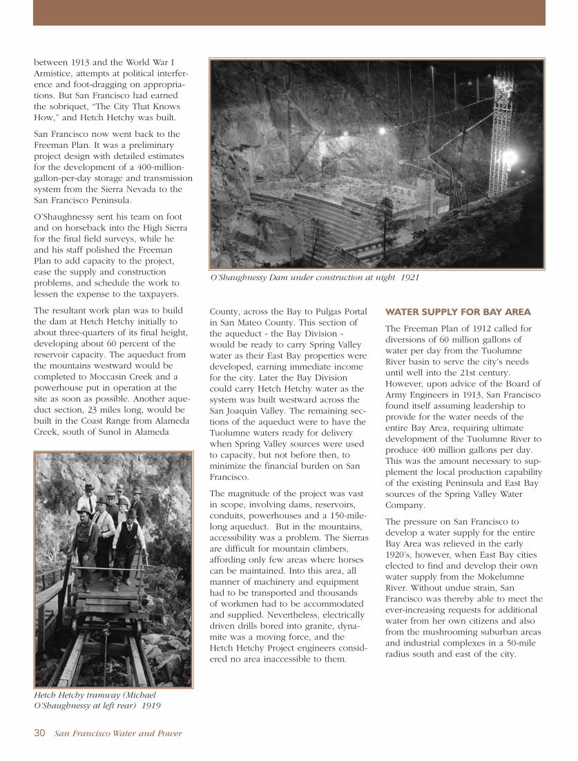
between 1913 and the World War IArmistice, attempts at political interfer-ence and foot-dragging on appropria-tions. But San Francisco had earnedthe sobriquet, “The City That KnowsHow,” and Hetch Hetchy was built.
San Francisco now went back to theFreeman Plan. It was a preliminaryproject design with detailed estimatesfor the development of a 400-million-gallon-per-day storage and transmissionsystem from the Sierra Nevada to theSan Francisco Peninsula.
O’Shaughnessy sent his team on footand on horseback into the High Sierrafor the final field surveys, while he and his staff polished the Freeman Plan to add capacity to the project,ease the supply and construction problems, and schedule the work tolessen the expense to the taxpayers.
The resultant work plan was to buildthe dam at Hetch Hetchy initially toabout three-quarters of its final height,developing about 60 percent of thereservoir capacity. The aqueduct fromthe mountains westward would becompleted to Moccasin Creek and apowerhouse put in operation at thesite as soon as possible. Another aque-duct section, 23 miles long, would bebuilt in the Coast Range from AlamedaCreek, south of Sunol in Alameda
County, across the Bay to Pulgas Portalin San Mateo County. This section ofthe aqueduct - the Bay Division -would be ready to carry Spring Valleywater as their East Bay properties weredeveloped, earning immediate incomefor the city. Later the Bay Divisioncould carry Hetch Hetchy water as thesystem was built westward across theSan Joaquin Valley. The remaining sec-tions of the aqueduct were to have theTuolumne waters ready for deliverywhen Spring Valley sources were usedto capacity, but not before then, tominimize the financial burden on SanFrancisco.
The magnitude of the project was vastin scope, involving dams, reservoirs,conduits, powerhouses and a 150-mile-long aqueduct. But in the mountains,accessibility was a problem. The Sierrasare difficult for mountain climbers,affording only few areas where horsescan be maintained. Into this area, allmanner of machinery and equipmenthad to be transported and thousands of workmen had to be accommodatedand supplied. Nevertheless, electricallydriven drills bored into granite, dyna-mite was a moving force, and theHetch Hetchy Project engineers consid-ered no area inaccessible to them.
WATER SUPPLY FOR BAY AREA
The Freeman Plan of 1912 called fordiversions of 60 million gallons ofwater per day from the TuolumneRiver basin to serve the city’s needsuntil well into the 21st century.However, upon advice of the Board ofArmy Engineers in 1913, San Franciscofound itself assuming leadership toprovide for the water needs of theentire Bay Area, requiring ultimatedevelopment of the Tuolumne River toproduce 400 million gallons per day.This was the amount necessary to sup-plement the local production capabilityof the existing Peninsula and East Baysources of the Spring Valley WaterCompany.
The pressure on San Francisco todevelop a water supply for the entireBay Area was relieved in the early1920’s, however, when East Bay citieselected to find and develop their ownwater supply from the MokelumneRiver. Without undue strain, SanFrancisco was thereby able to meet theever-increasing requests for additionalwater from her own citizens and alsofrom the mushrooming suburban areasand industrial complexes in a 50-mileradius south and east of the city.
O’Shaughnessy Dam under construction at night 1921
30 San Francisco Water and Power
Hetch Hetchy tramway (Michael
O’Shaughnessy at left rear) 1919

DESIGN DECISIONS
The building of Hetch Hetchy is a fascinating saga, mainly due to its geo-graphic challenges. System designevolved over time as O’Shaughnessyconsidered the best way to secure San Francisco’s water supply for thenext 100 years. Hydraulics, durabilityand capacity for expansion droveO’Shaughnessy’s decisions. He locatedfacilities to maintain the hydraulicgrade line for a gravity-flow systemrather than pumping water acrossCalifornia, built tunnels instead ofpipelines where possible for theircapacity, longevity and ease of mainte-nance, and strengthened dam founda-tions to support additional storage inthe future. O’Shaughnessy’s design also took advantage of the mountain-ous sites to generate hydroelectricityfrom the water supply before deliver-ing it to the Bay Area.
The construction work was conductedin separate contracts that spanned over160 miles between the High Sierra damsite and the Bay Area. Precise designand construction were required to con-nect the several segments as they werebuilt into a cohesive water supply sys-tem. Dams and powerhouses in thehigh country, conduits and tunnelsthroughout the system, pipelines in theSan Joaquin Valley, and even acrossand under San Francisco Bay were to be constructed. The system wasplanned to permit later additions tovarious parts as the need arose, with-out changing its basic design or opera-tions.
Hetch Hetchy was built as economical-ly as possible, but where additionallabor was necessary to eliminate futureexpense or unreasonable maintenancecost, that work was done. Succeedingyears have amply demonstrated thatthe builders of Hetch Hetchy actedwisely.
The total initial cost of the HetchHetchy development - up to the firstdirect delivery of Tuolumne Riverwater to San Francisco in October 1934- was just over $100 million. The costwas met solely by the city, withoutState or Federal assistance. At the price,San Francisco bought a bargain!
GROVELAND HEADQUARTERS
Before building the essential elementsof the system, it was first necessary toget into the mountains with packersand guides, often using charteredstagecoaches and freight wagons out ofGroveland, a small mountain town leftover from the Gold Rush. It sits astridethe Big Oak Flat road into Yosemite.With the coming of San Francisco’swork forces into the area, Grovelandwas revitalized, booming for a decadeas headquarters for the Hetch HetchyProject. The quiet mountain villagefound itself suddenly with office andhospital buildings, homes for officialsand their families, and shops and oper-ating headquarters for a full scale rail-road, bringing the first locomotives andcars that some in Groveland had everseen. Hetch Hetchy workers andequipment helped with extensive roadimprovements in the district. Theyimproved the water supply and starteda sewer system. They also resurveyedGroveland and nearby Big Oak Flat tocorrect inaccurate surveys made duringthe Gold Rush days.
HETCH HETCHY RAILROAD
Preliminary planning for the HetchHetchy Project revealed the need tobuild transportation, electrical powerand sawmill facilities to support con-
struction of the large-scale dams andtunnels in the back country. Planswere developed to build a railroad,sawmill and powerhouse in advance of dam construction.
In the rugged and remote country ofthe High Sierra, the first priority was areliable, high-capacity and all-weatherform of transportation to move heavymachinery, bulk materials and supplies,and workers into the mountains to thenew dam site. Clearly, a railroad wasthe answer.
So, San Francisco built the HetchHetchy Railroad, a 68-mile-long, standard gauge railway, from HetchHetchy Junction, some 26 miles east of Oakdale, to the rim of the HetchHetchy Valley. Built for some $3 mil-lion, Hetch Hetchy Railroad saved atleast ten times its cost in cement haul-ing alone. It was completed in October1917, and operated around the clockduring the construction of the dam,using one rented locomotive and six of its own.
Hetch Hetchy Railroad operated as acommon carrier from July 1918 toFebruary 1925, subject to rules of theCalifornia Railroad Commission. It abidedby railroading practices, publishing timetables and tariffs. Trains traveled at 8miles per hour top speed on very steepgrades, greater than four percent, and
San Francisco Water and Power 31
Roundhouse crew at Groveland 1922

around extremely sharp curves, some 30degrees or a 190-foot radius. The highestelevation on the line was 5,064 feet atPoopenaut Pass.
But it was a different sort of railroad.Mayor Rolph was president of the line,Chief O’Shaughnessy was vice presi-dent and general manager. There wasconsiderable informality in its opera-tion - the management consisted ofcivil engineers, not locomotive engi-neers.
To generate revenues for its operation,the railroad hauled freight for timbercompanies and others doing businessin the Sierra, charging 12½ cents perton mile for carload lots. It also car-ried the mail and provided passengerservice. Passengers paid 7½ cents permile. Weekend excursion groups of 40to 100 San Franciscans would leave thecity by Pullman sleeper Friday night,catching the Hetch Hetchy train onSaturday morning. Public support forbond issues was essential to financethe ongoing construction, so HetchHetchy excursion trains took communi-ty groups to various camps to view thework in progress, with meals andovernight accommodations being pro-vided at bunkhouses. After two days inthe mountains, the groups werereturned to their Pullmans on Sundayevening and they arrived in SanFrancisco ready for work Mondaymorning. The fare for this mountainholiday was about $30.
Most of the mountain construc-tion work was completed by themid-1920s, but the railroad waskept in use for another twodecades, mostly for winter sup-ply and maintenance whilemotor roads were snowbound.The railroad was again used forconstruction in the 1930s to haulmaterials and workers to raiseO’Shaughnessy Dam to its cur-rent height of 430 feet. TheState Emergency Relief Act pro-vided some 600 maintenanceworkers to help rebuild theHetch Hetchy Railroad bed andtracks. But this time HetchHetchy did not run the railroad.Sierra Railway came in with thelow bid and railroad operationsstarted again on May 13, 1935.
The tracks were removed in 1949, andparts of the right-of-way were used byState Highway 120 in Big Oak Flat, as well as the Cherry Oil Road toCamp Mather and beyond to theO’Shaughnessy Dam. One of HetchHetchy’s original six locomotives canstill be seen at Yosemite National Park,where it is on display.
THE SAWMILL
The original Hetch Hetchy Sawmill waslocated at Canyon Ranch in YosemiteNational Park, near a large forestowned by San Francisco about 4.5
miles from the Hetch Hetchy construc-tion site. Eight million board feet were sawed from 1915 through 1918.In 1919 after the timber stand wasexhausted, the mill was moved to Hog Ranch, some nine miles from theO’Shaughnessy Dam site. The opera-tion was discontinued in 1924, after 21million board feet of lumber had beencut. The mill was later dismantled, andHog Ranch is now San Francisco’ssummer recreation camp, CampMather, christened by O’Shaughnessyafter Stephen T. Mather, the firstDirector of the National Park Serviceand later Assistant Secretary of theInterior. The old mill pond at HogRanch is now a fine swimming lake for Camp Mather’s summer visitors. A smaller sawmill operated at LakeEleanor through 1918.
EARLY INTAKE POWERHOUSEAND LAKE ELEANOR
O’Shaughnessy’s plans for building theHetch Hetchy Project involved workingat night on dam construction, a vision-ary idea at the time. He needed agood, dependable source of electricityto run the boring drills, constructiontools and other equipment, as well asprovide full illumination in the dark,forested mountain work sites. Alongwith the railroad and sawmill, buildinga powerhouse was an early priority forO’Shaughnessy.
San Francisco built the tiny EarlyIntake Powerhouse on the TuolumneRiver about 12 miles downstream fromHetch Hetchy. Construction started inAugust 1917, supervised by AssistantChief Engineer Nelson A. Eckert. EarlyIntake was equipped with three 1,500-horsepower Francis turbines connecteddirectly to three 2.3-kilovolt (kV) gen-erators.
To assure continuous operation of thepowerhouse, O’Shaughnessy needed areliable and plentiful supply of water.He built the first dam of the HetchHetchy Project on Eleanor Creek. Thedam is a multi-arch concrete design,1,260 feet long and 70 feet high, creat-ing a reservoir impounding 27,100 acrefeet. It was completed quickly, placedin operation only ten months after thestart of construction in August 1917.
Aerial hoists move heavy timber 1918
32 San Francisco Water and Power
Early Intake Tramway carries visitors to dedicate the dam 1923

Prior to the dam, Lake Eleanor was atypical shallow glacial lake.
Also in 1917, a small 4-foot diversiondam was built to move Cherry Creekwaters into Lower Cherry Aqueduct. A three-mile long transmission systemof flumes, pipes, tunnels and concrete-lined canals along the service road, the Aqueduct delivered the combinedCherry Creek and Lake Eleanor watersat 200 cubic feet per second to the hillside 345 feet above Early IntakePowerhouse.
The 22 kV transmission lines, rated the equivalent of 4,000 horsepower,carried the power 11 miles east to theO’Shaughnessy Dam site, and 22 mileswest to Moccasin. A two-mile line wastaken into Groveland and the HetchHetchy headquarters.
Electrical generation began in May1918. In 16 years, the powerhouseproduced $550,000 worth of power for Hetch Hetchy construction and$750,000 in cash revenues from com-mercial power sales. Early IntakePowerhouse continued to operate until1967, adding its production to that ofthe Moccasin Powerhouse. Since 1960,water retained by Eleanor Dam isdiverted through the mile-long Eleanor-Cherry tunnel to Lake Lloyd (CherryLake).
Eleanor Dam under construction 1918
Moccasin power meters 1925
Original Moccasin turbines 1924
San Francisco Water and Power 33

O’SHAUGHNESSY DAM ANDHETCH HETCHY RESERVOIR
With completion of the Hetch HetchyRailroad, Sawmill and Early IntakePowerhouse, the infrastructure was inplace for O’Shaughnessy to begin workon the major Hetch Hetchy facilities.Preliminary work began in 1915 to cre-ate a reservoir collecting and storingthe runoff from 459 square miles ofrugged granite mountain watershed.The dam construction contract wasawarded to Utah Construction onAugust 1, 1919.
Built of cyclopean concrete, a processin which about eight percent graniteplums - blocks of stone ranging in sizefrom one cubic foot to five or six cubicyards - are embedded in plain con-crete, the dam is of the arch-gravitytype. It has five vertical contractionjoints, sealed by sheet copper strips,with inspection wells and ladder-waysat the construction joints.
Initially, 30 feet was considered anample depth for the dam’s foundations.But test boring of the ancient glacier’sterminal moraine discovered that theretreating glacier had dropped untoldtons of boulders, with intervening lay-ers of sand, to depths of more than 90feet below river level. At the down-stream toe of the dam, bedrock wasreached at 61 feet. But at the upstream
toe, the glacial debris had to beremoved to a depth of 101 feet.
Preliminary construction involved driv-ing a 1,000-foot-long diversion tunnelto carry the Tuolumne waters past thefoundation excavation during dam con-struction. The tunnel is 23 feet wideand 25 feet high through solid granite.
It took nearly four years of day andnight operations in all seasons to pourthe concrete brought in by the HetchHetchy Railroad. This totaled as muchas 2,000 cubic yards in a day, with theone-month record being 41,178 cubicyards. The dam was completed to itsinitial height of 226.5 feet, with a stor-age capability of 206,000 acre feet ofwater. At its dedication on July 7, 1923,it was acclaimed as the largest singlestructure on the West Coast.
When the mountain water reached SanFrancisco in 1934, the city’s engineersheaded back to the Sierra to increasethe height of the O’Shaughnessy Damand add to the capacity of HetchHetchy Reservoir. San Francisco hadapproved a $3.5 million bond issue forthis project in November 1933.Transbay Construction Company madethe low bid of $3,219,965 and con-struction started in January 1935.
The dam was raised 85.5 feet in eleva-tion in 1938, and enlarged to a length
of 910 feet at the crest and a width of 298 feet at the base, impounding its present 360,360 acre feet of water.The side-channel-type spillway hasthree drum gates installed in 1950, providing additional storage when thereservoir is full. Total cost of the dam,including its subsequent enlargement,was $12.6 million.
By the time this project was finished,the economy of Tuolumne County hadbeen given a timely boost. The nationwas making its way out of the GreatDepression. San Francisco was offereda 30 percent grant from the NationalRelief Administration, provided that all available unemployed Tuolumneworkers were put on the job.
Water from Hetch Hetchy Reservoir canbe released through 14 outlet conduitsin O’Shaughnessy Dam. Of these, threeoutlets move San Francisco’s drinkingwater into Canyon Power Tunnel forhydroelectric power generation atHetch Hetchy’s powerhouses beforethe water makes its way acrossCalifornia to the Bay Area.
The other 11 outlets are regulated by manually-operated valves rangingfrom three to six feet in diameter.Water is released into the TuolumneRiver downstream of the dam to main-tain river flows for fish habitat andrecreational uses, including whitewater rafting.
MOUNTAIN TUNNEL
At about the same time that preliminary work started on theO’Shaughnessy Dam during the sum-mer of 1917, city employees of theHetch Hetchy Project began construct-ing Mountain Tunnel from Early Intaketo Priest Reservoir above Moccasin.The tunnel is unlined for 38 percent of its length, and was drilled to a diam-eter of 13.5 feet through solid granite.The rest of the tunnel is ten feet indiameter and lined with concrete.Shaped like a horseshoe, the tunnel is designed for a flow capacity of 470million gallons per day.
O’Shaughnessy considered all privatecontracting bids for the MountainTunnel to be extravagantly high andrejected them. The excruciatingly diffi-
O’Shaughnessy Dam being raised 1937
DAM & TUNNEL CONSTRUCTION STARTS IN HIGH SIERRA
34 San Francisco Water and Power

cult work was therefore assigned toHetch Hetchy’s city forces, taking thebest of men, and putting the engineers’skills to an acid test.
The excavation work was conductedfrom twelve working faces. The head-ings from each face had to match up,horizontally and vertically, when crewsworking toward each other “holedthrough.” Of the working faces, fourwere portals, four were from adits(passageways leading to the tunnel)and four started from the bottom of the two shafts - Second Garrote Shaft,786 feet deep, and Big Creek Shaft, 646 feet.
The tunnel was completed in 1925 at a cost of $25 million. Most of MountainTunnel is an average of 1,000 feetbelow the surface. Where it crossedthe gorge of the South Fork of theTuolumne, it was interrupted by a 9.5 foot-in-diameter pipe, 225.5 feetlong. In the mid-1960s the pipe wasreplaced by a U-shaped tunnel underthe stream bed.
PRIEST RESERVOIR AND BYPASS
The west end of Mountain Tunnelcomes out some 19 miles east of EarlyIntake. Hetch Hetchy water is dis-
charged into Priest Reservoir, a regulat-ing reservoir for forebay capacity andflexible operation of the MoccasinPowerhouse. Located near the top ofPriest Hill, an hydraulic and earth-filldam was built around a concrete coreto capture the full force of the HetchHetchy flow from Mountain Tunnel.Rattlesnake Creek, a tributary of
Moccasin Creek, was diverted awayfrom the reservoir to prevent pollutionof San Francisco’s drinking watersource.
Priest Dam is 148 feet high, 1,600 feetlong and 660 feet wide at the base. It was built by Hetch Hetchy forces ata cost of $1 million. A concrete-linedspillway protects against overtoppingand a tunnel serves as an additionaloutlet to drain the reservoir.
In 2003, Hetch Hetchy forces managedand inspected the construction of a $13 million Priest Bypass pipeline, 19 feet in diameter and 17 inches thick,below the water level of the reservoir.The 1,200 foot-long bypass connectsMountain Tunnel to Moccasin PowerTunnel, fully enclosing the HetchHetchy supply until it reachesMoccasin Powerhouse in the Sierrafoothills. Completed in 2004, thepipeline was designed to bypass Priest Reservoir in the event of waterquality concerns, such as high turbidityfrom hillside runoff, bank erosion orforest fires.
Mucking machine in Priest Tunnel 1919
South Fork tunnel portal and buildings 1918
San Francisco Water and Power 35

MOCCASIN POWER TUNNEL
A concrete gate tower controls andregulates water release throughMoccasin Power Tunnel to the brow of the hill above Moccasin. A 160-foot-high surge shaft is near the down-stream end of the tunnel. The powertunnel is 5,370 feet long, horseshoe-shaped, concrete-lined, narrowing from 19 feet to 13 feet in width, with a capacity of 800 million gallonsper day. Completed at a cost of $1.3million, the power tunnel connectswith three penstocks, 5,349 feet long, which direct the water into the Moccasin Powerhouse 1,316 feetbelow. The penstocks were originallybuilt for $2.5 million.
OLD MOCCASIN POWERHOUSEAND CAMP
The old Moccasin Powerhouse, nolonger operational, is designed inCalifornia Mission style with a tile roofand arched arcades. Located on thebank of Moccasin Creek near the junc-tion of State Highways 49 and 120 -the Mother Lode Stage Coach and BigOak Flat Roads - the powerhouse restsat the foot of the infamous PriestGrade leading to Stanislaus NationalForest and Yosemite National Park. Anarduous passage from the earliest days,the old Priest Grade climbs 1,575 feetin two miles. The new road, StateHighway 120 - across Grizzly Gulchfrom the original - makes the sameclimb in eight miles. The name camefrom the Priest Station Hotel at the top
of the grade, operated by Mrs. WilliamPriest until 1905.
The old powerhouse is slated for historical preservation. At 225 feetlong, 98 feet wide and 67 feet high,with massive foundations resting onbedrock, the powerhouse and itsmachinery cost $2.4 million to build in 1925. During its 44 years of activeservice, four generators rated at 20kilowatts (kW) each produced $115million worth of electrical power.
Moccasin Camp, the original foothillheadquarters for construction andmaintenance of the entire HetchHetchy water storage, power and aqueduct system, continues to functionas the hub of the Hetch HetchyOperations Division to this day. Thelower camp near Moccasin Reservoir
was designed in the style of the oldpowerhouse, a cozy neighborhood ofCalifornia Mission stucco cottages withSpanish tile roofs, housing the adminis-trative offices, shops and the familiesof some Hetch Hetchy staff. In addi-tion to their daily management, opera-tions and maintenance duties, residentsof Moccasin Camp are essential emer-gency personnel, forming a volunteerunit that works together with theNational Park and Forest Services staffto control forest fires in San Francisco’s650 square miles of Sierra watershed.
NEW MOCCASIN POWERHOUSEAND RE-REGULATING RESERVOIR
New Moccasin Powerhouse, adjacent to the old powerhouse site, went intoservice in 1969, with two outdoor gen-erators, each rated at 50,000 kVA. Builtfor $8.3 million, the new powerhouseuses more sophisticated technologyrequiring less staff time for operationsand maintenance, and earns $250,000more annually than the old plant did.
Moccasin Re-regulating Reservoir, created by an earth-fill dam 50 feethigh and 855 feet long, functions as an afterbay for Moccasin Powerhouse,to collect the fluctuating flows resultingfrom hydroelectric power generation.Drinking water for San Francisco entersthe Foothill Tunnel upstream ofMoccasin Dam at the afterbay gatetower.
Should the need arise, San Francisco’sdrinking water can be diverted at theMoccasin Reservoir Bypass directly intoFoothill Tunnel, without surfacing atMoccasin Reservoir.
A later concrete dam, 321 feet long,was built upstream of the afterbay toprevent the potentially muddy anddebris-filled waters of Moccasin Creekfrom contaminating the reservoir.Moccasin Creek waters are divertedthrough the 2,900-foot-long MoccasinCreek Diversion Pipeline, laid on thefloor of the afterbay and dischargeddownstream along the original creekbed.
Water formerly spilled at Moccasin isnow harnessed to produce hydroelec-tric power by a $10 million low-headgenerating plant, which went into
C O N S T R U C T I O N B E G I N S I N S I E R R A F O O T H I L L S
36 San Francisco Water and Power
Old Moccasin Powerhouse under construction 1924
Moccasin Camp 1920

operation at Moccasin in 1986 with arating of 3 megawatts (MW). Low-headgenerating plants provide additionalpeak production for municipal andindustrial electrical loads.
FOOTHILL TUNNEL
From Moccasin, San Francisco’s drink-ing water continues westward in anentirely enclosed conduit of tunnelsand pipes until it reaches Pulgas WaterTemple in the San Francisco Bay Area.The first leg of this journey is the 15.8-mile Foothill Tunnel through the SierraNevada’s western foothills. At OakdalePortal, south of Knight’s Ferry, connec-tion is made with the San JoaquinValley Pipelines.
Tunnel construction started in 1926.Construction headquarters had beenmoved from Groveland to HetchHetchy Junction in November 1925.After the opening of Pedro Adit, thetunnel was soon drilled and blastedfrom ten separate construction faces -four from two shafts at Hetch HetchyJunction and Rock River, four fromPedro and Brown Adits, and two fromthe tunnel portals.
The Foothill Tunnel line crosses theTuolumne River canyon at RedMountain Bar, some five miles west ofMoccasin. The river crossing was madewith an inverted siphon - 770 feet ofsteel pipe 9.5 feet in diameter, locatedin a trench blasted from bedrock andembedded in concrete 18 inches totwo feet thick. The pipe interior is
coated with 1.5 inches of cement mortar.
The Red Mountain Bar siphonwas not initially required, but thecanyon would soon be floodedto a depth of 80 feet by DonPedro Lake. The Don Pedro Damwas being constructed at thesame time as O’ShaughnessyDam by the Turlock andModesto Irrigation Districts.
During the three years of workon the Foothill Tunnel, a narrowgauge railway was laid from theeast bank of the Tuolumne tothe Brown Adit, 1.5 miles away,and into the tunnel itself. A sid-ing was built on the west side ofthe river alongside the HetchHetchy Railroad main line. Theriver was crossed by a half-mile-long, Lidgerwood steel cablewayhigh above the canyon. A hoist-ing system suspended betweentwo towers, the cableway couldcarry a five-ton load of suppliesand men from the main railroad sidingacross the river canyon to the narrowgauge line in two minutes. At the time,the Lidgerwood cableway set a worldrecord in span length for a hoistingand conveying cable line; later, similarcableways were used to build HooverDam and the Panama Canal.
Work on the Foothill Tunnel was start-ed from six work camps by HetchHetchy city forces. City workersinstalled the water systems, power andtelephone lines, roads, camps and
other facilities nec-essary to supportconstruction, andalso drove some1,000 feet of tunnelto expose the geol-ogy in the workface headings toprivate contractorsto bid on some ofthe remainingwork.
Three of the workcamps were subse-quently turned overto contractors whobid successfully onthe project. Not
only did a spirit of competition growbetween the city’s work forces andthose of private contractors working on adjacent tunnel sections, but directcomparisons of costs for similar workbecame possible.
Completely outworking the privatecontractors, Hetch Hetchy’s workers seta new record for one month’s tunnel-ing excavation in March 1926 - 781 feet at the Hetch Hetchy Junction eastheading. Six months later city forcesbroke their own record at the samework face - 803 feet in September -setting a new national record for thistype of work.
Foothill Tunnel was completed in 1929,at a total cost of $8 million. ChiefO'Shaughnessy later reported that tun-neling costs for city work came to$35.53 per foot, while contractor costwas $40.49. City costs for placing con-crete lining came to $36.11 per foot,while the average contractors’ cost was $47.38.
San Francisco Water and Power 37
Moccasin Penstocks 1923
Old Moccasin Powerhouse 1923

SAN JOAQUIN PIPELINES
From Foothill Tunnel, Hetch Hetchywaters are piped under pressure 47.5miles across California’s San JoaquinValley through three pipelines, builtover a period of 37 years.
O’Shaughnessy anticipated the SanFrancisco Bay Area’s growing need forwater, and provided a 100-foot right ofway for the aqueduct, sufficient spaceto build four parallel pipelines overtime. The fourth bore has yet to bebuilt, but is in the planning stagesnow, more than 70 years after the firstpipeline was completed.
Water supplies enter the San JoaquinPipelines at Oakdale Portal, wherevalves control the flow in all threelines, and is discharged into the CoastRange Tunnel at Tesla Portal, sevenmiles south of Tracy. Dropping belowsea level, the pipelines pass 15 feetunder the deep San Joaquin River andnearby Elliott Cut, where they are sup-ported by timber piles and encased inreinforced concrete jackets.
Construction of Pipeline No. 1 startedin 1931 and was completed the nextyear. The pipe is welded and rivetedsteel with a diameter that varies from56 to 72 inches. Originally coated withasphalt and wrapped with asphaltumfelt, in 1953 the interior asphalt liningwas removed and replaced withcement mortar. At a construction costof $5 million, the capacity of PipelineNo. 1 is 70 million gallons per day.
Pipeline No. 2, with a capacity of 80million gallons a day, was completedin 1953 in response to regional growthduring the baby boom. With an insidediameter of 61 inches throughout itslength, the line includes 28.5 miles ofwelded steel pipe, coated and linedwith cement mortar, and 18.5 miles ofreinforced concrete pipe. The line cost$12.3 million to build.
Pipeline No. 3 is the largest of thethree with a capacity of 150 milliongallons a day. East of the San JoaquinRiver it is 78 inches in diameter, linedwith coal tar enamel. Completed in1968 at a cost of $19.5 million, it dou-bled the aqueduct capacity to a totalfor all three pipelines of 300 milliongallons per day.
At the San Joaquin River crossing, auto-matic pressure relief valves on all threelines discharge into the river in case ofexcess pressure.
COAST RANGE TUNNEL ANDCONSTRUCTION DELAYS
One of the largest and most dramaticof the Hetch Hetchy undertakings, theCoast Range Tunnel is the final leg ofthe journey for Sierra Nevada watersbefore reaching the San Francisco BayArea. This 28.5-mile-long tunnelthrough the Coast Range Mountains isin two sections - a 25-mile-long contin-uous tunnel from Tesla Portal toAlameda Creek, which was the longestin the world upon completion, and a3.5-mile segment from Alameda Creekto Irvington Portal near Mission SanJose. At Alameda Creek, the two tun-nel segments are connected by a multi-ple-pipe, inverted siphon, one-half milelong across the creek and Sunol Valley.The short section of tunnel through theCoast Range between the AlamedaSiphons and Irvington Portal is nowcalled Irvington Tunnel.
At the Alameda Siphons, interconnect-ing pipelines were built to transportlocal water supplies from SanFrancisco’s reservoirs in the East Bay tothe Sunol Valley Water Treatment Plant,
and back to the Hetch HetchyAqueduct for transmission through theBay Division pipelines.
O’Shaughnessy’s master plan for HetchHetchy scheduled tunnel constructionto start in the winter of 1925, but thework was delayed awaiting approval ofthe budget by the city’s Board ofSupervisors. When the budget wasfinally adopted in 1927, tunnel drillingstarted without delay.
Part of the two-year delay was causedby an increasing number of critics whoviewed with alarm the hazardousworking conditions, including flamma-ble gases, groundwater, quicksand andswelling ground. Some engineers andpolitical groups wanted the HetchHetchy water pumped over the CoastRange to save time and the expense of tunneling. O’Shaughnessy provedthat a pipeline providing 60 milliongallons per day, plus the pumpingcosts, would cost almost as much as a 200-million-gallon-per-day gravity-flow tunnel. Also, the pipeline wouldrequire a supplementary line in 12years, while the pumping costs wouldgo on forever!
Possible earthquakes were also forecastby tunnel critics. This threat was wellknown to the engineers; fracture areasof two earthquake fault lines were
Coast Range Tunnel workers outside Mitchell Shaft 1934
38 San Francisco Water and Power
A Q U E D U C T S P A N S N O R T H E R N C A L I F O R N I A
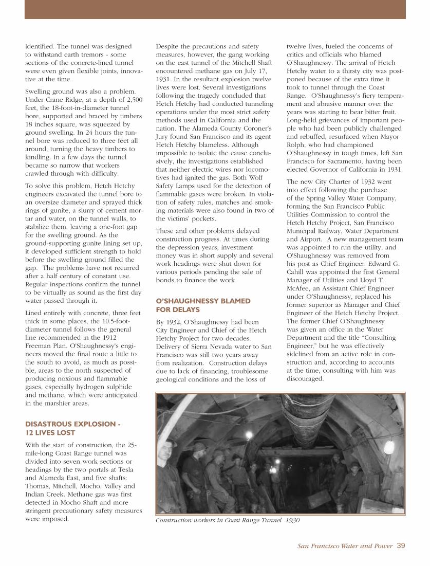
identified. The tunnel was designed to withstand earth tremors - some sections of the concrete-lined tunnelwere even given flexible joints, innova-tive at the time.
Swelling ground was also a problem.Under Crane Ridge, at a depth of 2,500feet, the 18-foot-in-diameter tunnelbore, supported and braced by timbers18 inches square, was squeezed byground swelling. In 24 hours the tun-nel bore was reduced to three feet allaround, turning the heavy timbers tokindling. In a few days the tunnelbecame so narrow that workerscrawled through with difficulty.
To solve this problem, Hetch Hetchyengineers excavated the tunnel bore toan oversize diameter and sprayed thickrings of gunite, a slurry of cement mor-tar and water, on the tunnel walls, tostabilize them, leaving a one-foot gapfor the swelling ground. As theground-supporting gunite lining set up,it developed sufficient strength to holdbefore the swelling ground filled thegap. The problems have not recurredafter a half century of constant use.Regular inspections confirm the tunnelto be virtually as sound as the first daywater passed through it.
Lined entirely with concrete, three feetthick in some places, the 10.5-foot-diameter tunnel follows the generalline recommended in the 1912Freeman Plan. O'Shaughnessy's engi-neers moved the final route a little tothe south to avoid, as much as possi-ble, areas to the north suspected ofproducing noxious and flammablegases, especially hydrogen sulphideand methane, which were anticipatedin the marshier areas.
DISASTROUS EXPLOSION - 12 LIVES LOST
With the start of construction, the 25-mile-long Coast Range tunnel wasdivided into seven work sections orheadings by the two portals at Teslaand Alameda East, and five shafts:Thomas, Mitchell, Mocho, Valley andIndian Creek. Methane gas was firstdetected in Mocho Shaft and morestringent precautionary safety measureswere imposed.
Despite the precautions and safetymeasures, however, the gang workingon the east tunnel of the Mitchell Shaftencountered methane gas on July 17,1931. In the resultant explosion twelvelives were lost. Several investigationsfollowing the tragedy concluded thatHetch Hetchy had conducted tunnelingoperations under the most strict safetymethods used in California and thenation. The Alameda County Coroner’sJury found San Francisco and its agentHetch Hetchy blameless. Althoughimpossible to isolate the cause conclu-sively, the investigations establishedthat neither electric wires nor locomo-tives had ignited the gas. Both WolfSafety Lamps used for the detection offlammable gases were broken. In viola-tion of safety rules, matches and smok-ing materials were also found in two ofthe victims’ pockets.
These and other problems delayedconstruction progress. At times duringthe depression years, investmentmoney was in short supply and severalwork headings were shut down forvarious periods pending the sale ofbonds to finance the work.
O’SHAUGHNESSY BLAMED FOR DELAYS
By 1932, O’Shaughnessy had been City Engineer and Chief of the HetchHetchy Project for two decades.Delivery of Sierra Nevada water to SanFrancisco was still two years awayfrom realization. Construction delaysdue to lack of financing, troublesomegeological conditions and the loss of
twelve lives, fueled the concerns ofcritics and officials who blamedO’Shaughnessy. The arrival of HetchHetchy water to a thirsty city was post-poned because of the extra time ittook to tunnel through the CoastRange. O’Shaughnessy’s fiery tempera-ment and abrasive manner over theyears was starting to bear bitter fruit.Long-held grievances of important peo-ple who had been publicly challengedand rebuffed, resurfaced when MayorRolph, who had championedO’Shaughnessy in tough times, left SanFrancisco for Sacramento, having beenelected Governor of California in 1931.
The new City Charter of 1932 wentinto effect following the purchase of the Spring Valley Water Company,forming the San Francisco PublicUtilities Commission to control theHetch Hetchy Project, San FranciscoMunicipal Railway, Water Departmentand Airport. A new management teamwas appointed to run the utility, andO'Shaughnessy was removed from his post as Chief Engineer. Edward G.Cahill was appointed the first GeneralManager of Utilities and Lloyd T.McAfee, an Assistant Chief Engineerunder O’Shaughnessy, replaced his former superior as Manager and ChiefEngineer of the Hetch Hetchy Project.The former Chief O’Shaughnessy was given an office in the WaterDepartment and the title “ConsultingEngineer,” but he was effectively sidelined from an active role in con-struction and, according to accounts at the time, consulting with him wasdiscouraged.
Construction workers in Coast Range Tunnel 1930
San Francisco Water and Power 39

The new Charter required a competi-tive bidding process to complete theCoast Range Tunnel construction.Hetch Hetchy also had the right to bidand came in at $5,257,665, over half amillion dollars less than the next low-est bid. When city forces finished theproject, they still had some $1.5 millionleft over. In addition to the twelvemen, the tunnel cost $28 million tobuild.
The final holing through of the CoastRange Tunnel came on January 5,1934, between the Mitchell and Mochoaccess shafts, in the presence of,among others, Mayor Angelo Rossi,SFPUC Commissioners Lewis Byingtonand Erwin Eddy, and Utilities GeneralManager Edward Cahill. The CoastRange Tunnel was the last of facilitiesto be built in the aqueduct thatstretched more than 160 miles acrossCalifornia to bring the mountain watersof Hetch Hetchy to the San FranciscoBay Peninsula. To honor the system’sengineer, the ceremony of drillingthrough the last 12 inches of tunnelwas briefly halted until O’Shaughnessycould arrive to take the first handshakefrom foreman Pete Peterson.
BAY CROSSING PIPELINE NO. 1 -SPRING VALLEY FINANCESSTART OF CONSTRUCTION
From Irvington Portal, the HetchHetchy waters only had to travelanother 25 miles to reach thePeninsula. Spring Valley’s AlamedaPipeline, built in 1888, consisted of 20miles of riveted steel pipe 36 inches indiameter, followed by a 6,400-foot sec-tion of two submerged 16 inchpipelines on the floor of San FranciscoBay, too small to carry planned HetchHetchy water supplies. Spring Valley’sdeliveries were also constrained by thesubmarine pipes, and they becameinterested in San Francisco’s proposalsfor a new Bay Crossing Pipeline.
By the time San Francisco was ready tobuild the first Bay Crossing Pipeline, itappeared that all of the $45 millionoriginally authorized in 1910 to con-struct Hetch Hetchy had been expend-ed. The city planned to requestauthority from San Francisco voters inOctober 1924 to issue $10 million inrevenue bonds to complete the project,but that would result in an unaccept-able construction shut down of nearlytwo years, laying off some 500 trainedmen with no guarantee of their returnwhen work resumed. An alternative,
to hold an early, special election for aninterim $1 million bond issue was alsorejected, due to its high $35,000 cost, awork stoppage of six months or more,and accompanying worker layoffs.
Rather than go for the $1 million bondissue and its associated costs anddelays, Hetch Hetchy approached theSpring Valley Water Company forfinancing to begin construction of thetransbay line. Under the terms of the1911 State Railroad Commission order,the water arbiter at the time, and the1922 agreement between Spring Valleyand San Francisco, the city acquired anoption to buy the Spring Valley WaterCompany and its assets to integratewith the Hetch Hetchy system oncecompleted. Spring Valley agreed tocooperate with the city's request, andadvanced four annual payments of$250,000 each, as pre-paid rent for itsuse of the Pipeline No. 1.
The private company did not make anymoney on this deal. It used its owngood credit to borrow the money atthe lowest available rates. SanFrancisco compensated Spring Valleyfor the interest costs so that the watercompany neither made nor lost moneyon the transaction. But, at the sametime, Spring Valley was required toborrow money to finance its own con-struction work.
In an Oakland Tribune editorial onDecember 12, 1924, referring to “con-troversies which have hindered andthreatened to halt the work...,” theTribune opined, “In the light of history,it seems a little incongruous that at themost critical period in the HetchHetchy war, and when the money wasnot available, the much-malignedSpring Valley Water Company came tothe front to furnish the funds to com-plete the job. Volumes might be writtenon the subject, but suffice to say thecompany is to be commended...regardless of the fact that those whoberated it and made it a target aresome of those who are most prominentin Hetch Hetchy circles...”
Pipeline No. 1 was constructed 60inches in diameter in a trench 25 feetdeep in the mud and 75 feet below the
Construction of submarine sections of Bay Crossing Pipeline No. 1 1925
40 San Francisco Water and Power

water surface at Newark Slough andDumbarton Strait. Completed in 1925 ata total cost of $6 million, the 21-mile-long line was put to use immediatelyper the agreement with Spring ValleyWater Company to augment their ownsmall line carrying Alameda waters tothe Peninsula. When Pipeline No. 1entered service, Spring Valley’sPeninsula storage contained only 70days water supply for the city.
Construction on the 1.7-mile longPulgas Tunnel, the western terminus ofthe Hetch Hetchy Aqueduct in SanMateo County, was started June 23,1922. By 1924 it carried Spring Valleywater under a lease agreement sixyears before the city was to purchasethe private water system in 1930.
BAY DIVISION PIPELINE NOS. 2, 3 & 4
In October 1924, San Francisco votersapproved an additional $10 million to complete the Coast Range Tunneland Bay Crossing, but this new moneywas not to be available until afterJanuary 1, 1925.
To increase water delivery capacity onthe Hetch Hetchy Aqueduct, construc-tion started on Bay Crossing PipelineNo. 2 in the summer of 1934, a fewmonths after completion of the CoastRange Tunnel. Running parallel toPipeline No. 1 in the same right-of-wayacross San Francisco Bay, Pipeline No.
2 is slightly larger at 62 to 66 inches indiameter. It was completed in 1936 at acost of $4 million.
Pipeline Nos. 3 and 4 are each 34miles long and rather than cross theBay, they follow an underground right-of-way around its south end. The BayCrossing Pipelines were renamed BayDivision Pipelines, which together withthe two new transmission lines, werenumbered 1 through 4 by date of con-struction. Separating the four pipelinesinto two pairs along very differentalignments created operational advan-tages for delivery reliability, providinginsurance against the loss of water sup-plies in a major earthquake or othernatural disaster.
The Bay Division Pipelines differ incomposition along their alignments,depending on their underlying groundor submarine conditions, consisting inportions of riveted steel, welded steel,reinforced steel cylinder and pre-stressed concrete. Completed in 1956,No. 3 is 72 to 78 inches in diameterand cost $10 million to build. PipelineNo. 4 is the largest, with a diameterranging from 84 to 96 inches. Its finaleight-mile link was completed on June14, 1973 at a cost of $5.6 million,bringing the total transbay transmissioncapacity to 307 million gallons per day.
Bay Division Pipeline No. 1 on Trestle Bridge 1925
San Francisco Water and Power 41
Crystal Springs Pipeline No. 1 after earthquake 1906

HETCH HETCHY WATER REACHES SAN FRANCISCO PENINSULA
CRYSTAL SPRINGSBYPASS TUNNEL
The Crystal Springs Bypass Tunnel wasthe realization of a Water Departmentplan to bring water directly from theHetch Hetchy Aqueduct and the SunolFiltration Plant into San Francisco andnorthern San Mateo County, bypassingLower Crystal Springs Reservoir tostreamline water deliveries and avoidthe additional costs of surface watertreatment on the Peninsula.
The tunnel was designed as a 3.25-mile-long bypass, nine feet in diameterand lined with concrete. Along withits connecting pipeline to the existingCrystal Springs Pipelines, the tunnelwas completed in 1968 at a total costof $8.6 million.
In 1975, a new $4.6 million, 60-million-gallon covered balancing reservoir, wasbuilt with its attendant pumping stationnear the Pulgas Water Temple, to coor-dinate the flows through Pulgas Tunnelinto Crystal Springs Reservoir.
PULGAS WATER TEMPLE
The Pulgas Water Temple, borderingthe Crystal Springs Reservoir, marks theterminus of the Hetch Hetchy aqueductthat conveys Tuolumne River watermore than 160 miles from the SierraNevada to the San Francisco Bay Area.On October 28, 1934, the rush ofHetch Hetchy mountain water greeteda festive crowd of dignitaries gatheredat the temple to celebrate its arrival.
With vivid memories of the fire thathad raged unchecked for lack of waterfollowing the 1906 earthquake, SanFrancisco rejoiced in its new secure,plentiful supply of high quality drink-ing water.
A new temple was designed in theBeaux Arts style by William Merchant,a San Francisco architect trained byBernard Maybeck, completed in 1938.Merchant’s design featured flutedcolumns and Corinthian capitals toreflect the architecture of ancientGreeks and Romans, whose engineer-ing methods were used to build thenew water system. Artist and masterstone carver Albert Bernasconi broughtMerchant’s drawings to life. The friezeabove the columns expresses the city’sjoyful relief at its new source: “I givewaters in the wilderness and rivers inthe desert, to give drink to my people.”
O’SHAUGHNESSY TRAGICALLYMISSES HISTORIC DAY
By October 1934, San Francisco votershad authorized seven bond issues for a total of nearly $102 million to financethe Hetch Hetchy work: $600,000 in1910, $45 million in 1910, $10 millionin 1924, $24 million in 1928, $6.5 mil-lion in 1932, $3.5 million and $12.1
million in 1933. The terrible cost inhuman life to bring a secure, highquality water supply from the Sierra toSan Francisco was 89 workers, includ-ing 12 workers lost in the Coast RangeTunnel disaster.
The first flow of mountain water intothe San Francisco distribution systemwas an historical event, celebratednationally on the occasion via radio onOctober 24, 1934. Accompanied bythe Municipal Band, San FranciscoPublic Utilities Commission PresidentLewis Byington introduced the buildersof Hetch Hetchy. Interior SecretaryHarold Ickes, Mayor Angelo Rossi andSupervisor Jesse Coleman addressedthe assembly and the nation over theColumbia Broadcasting System (CBS)coast-to-coast network, paying tributeto Chief O’Shaughnessy, but he wasnot there to hear it. Tragically, in theearly morning hours of Friday, October12, the 72-year-old O’Shaughnessypassed away at his home, after com-plaining of a pain over his heart.
42 San Francisco Water and Power
Dedication ceremony for completion of Hetch Hetchy System, Pulgas Water Temple 1934
Pulgas Water Temple 1940

CHERRY VALLEY SYSTEM
After raising O’Shaughnessy Dam in1938, Hetch Hetchy engineers movedon to Cherry Creek Canyon, about 17miles northwest. The Raker Act hadauthorized a third impounding reser-voir in this valley to provide additionalsupply reliability and develop newenergy resources.
San Francisco and the Modesto andTurlock Irrigation Districts had mutualinterests in a new storage reservoir onCherry Creek. San Francisco wanted toassure the reliability of its supply,while the two Irrigation Districts facedincreasing demands for irrigation sup-plies from expanding agriculturaldevelopment in the Central Valley.
Developing storage on the CherryRiver, a tributary of the Tuolumne,would enable San Francisco to satisfyits obligations for daily releases to thetwo Irrigation Districts as requiredunder the Raker Act, while preservingthe high quality Hetch Hetchy supplyfor San Francisco’s domestic water use.
The Army Corps of Engineers alsobecame interested in the city's discus-sions about water storage facilities inthe Cherry Valley, to address their con-cerns about ongoing damage fromflooding on the lower reaches of theTuolumne and San Joaquin Rivers.
Starting exploratory work in the CherryValley in 1941, San Francisco spent$200,000 over the next eight years toprotect its rights and program the wayuntil the four interested agenciesentered into a cooperative agreementin 1949.
The agreement provided and requiredthat:
San Francisco and the Modesto andTurlock Irrigation Districts wouldmodify their existing facilities, con-struct new facilities, and operatethem to reserve reservoir space forprotection against Tuolumne Riverfloods, in accordance with regula-tions established by the Corps ofEngineers.
San Francisco would construct a reservoir in Cherry Valley immediately.
The Irrigation Districts would devel-op a new, larger reservoir on thelower Tuolumne at a later date,below the old Don Pedro Dam,inundating it.
Upon completion of this larger NewDon Pedro Reservoir, all flood con-trol operations on the Tuolumnewould be transferred to it.
For flood control benefits, theFederal Government would pay $9million toward construction of the$13 million Cherry Valley Reservoirand a subsequent amount (about$5.4 million) toward building theNew Don Pedro Reservoir.
For the right to use a stipulatedamount of storage space in NewDon Pedro, San Francisco wouldpay $45 million toward its construc-tion.
The Cherry Valley project started in1950. Heavy equipment had to be car-ried to the work site, so 26 miles ofroads were built through ruggedcanyons and over mountain ridges.Power was supplied by a 10-mile-longpower line on wooden poles from thevenerable Early Intake Powerhouse. A diversion tunnel, 17 feet in diameterand a quarter-mile long, was driftedaround the dam site.
Six years later, in 1956, the hugeCherry Dam was complete - 330 feethigh above bedrock, 2,600 feet long,and 1,320 feet thick at the base. Acomposite earth and rock embankmentdam, the central impervious core is ofcompacted, decomposed granite. Thediversion tunnel was made a perma-nent outlet.
The reservoir formed by Cherry Dam,informally called Cherry Lake, wasnamed Lake Lloyd in honor of Harry E.Lloyd, who was General Manager andChief Engineer for Hetch Hetchy from1952 to 1961.
Freeman’s Plan contemplated a muchsmaller Cherry Lake, diverting to amuch larger Lake Eleanor, which inturn would divert via a tunnel to HetchHetchy Reservoir for delivery to SanFrancisco. The Raker Act provisionsgranting Modesto and Turlock signifi-cantly increased water diversions dur-ing the spring runoff necessitated achange in the system’s design. TheCherry system was reconsidered, and anew design developed principally togenerate hydroelectric power for SanFrancisco, and divert the system’swater supplies downstream to NewDon Pedro Reservoir to satisfy theCity’s obligations to the IrrigationDistricts.
Cherry Dam and Lake Lloyd (Cherry Lake) 1960
San Francisco Water and Power 43
H E T C H H E T C H Y H Y D R O E L E C T R I C S Y S T E M

A six-mile-long, horseshoe-shapedpressure tunnel, 12 feet wide and 12.5feet high, was bored through granitefrom Cherry Dam to Dion R. HolmPowerhouse to generate hydroelectricpower before the water was returnedto the river for delivery to the IrrigationDistricts. The tunnel has a 400-foot-tallsurge shaft and a rock trap near thedownstream portal.
The Lake Eleanor watershed, whichhas a higher yield than the small lakecan hold, supplements storage in theCherry system via the Cherry-EleanorAqueduct and Pump Station, a mile-long tunnel drifted through the ridgebetween the two lakes which drainsEleanor water into Lake Lloyd.
DION R. HOLM POWERHOUSE
Development of the two additionalhydroelectric power plants in theHetch Hetchy system was delayed untilthe early 1960s to consider dispositionof the energy created in compliancewith Raker Act provisions. Since SanFrancisco does not own its municipalelectric distribution system, HetchHetchy energy is delivered at bulktransmission voltages to other agenciesfor resale, or for wheeling, or transport,to the city’s municipal loads and cus-tomers under contractual agreementswith Pacific Gas and Electric Company(PG&E).
Dion R. Holm Powerhouse on theCherry River, six miles downstreamfrom the Cherry Valley Dam, came online in 1960, and is the largest of thethree Hetch Hetchy powerhouses. Eachof its two vertical-shaft, turbine-drivengenerators is rated at 82,500 kilovoltamps (kVA). Voltage is stepped up to230 kilovolts (kV) to transmit thepower 1.5 miles to the Early IntakeSwitchyard.
Water for the powerhouse comes fromthe Cherry Power Tunnel and enters a6,800-foot-long steel penstock.Tapering from 7.5 feet in diameter atthe top to 5 feet at the powerhouse,the penstock drops the water 2,100vertical feet. To withstand the highpressure, the penstock pipe is madefrom steel plate increasing in thicknessfrom less than one inch at the top to2.5 inches at the bottom.
The Holm Power Plant, Tunnel,Penstock and all equipment excepttransmission lines represented aninvestment of $25 million for SanFrancisco.
The powerhouse was named after DionR. Holm on August 25, 1967 to memo-rialize the former City Attorney whoserved as Hetch Hetchy counsel duringthe early operating years and who wasa devoted advocate of the water andpower system.
CANYON POWER TUNNEL
The 11-mile-long Canyon PowerTunnel takes Hetch Hetchy water from the base of O’Shaughnessy Dam through a steel pipe, nine feet in diameter, encased in concrete.Mainly unlined, it is horseshoe-shaped, 14 feet wide and 14.5 feethigh. Sloping 10.5 feet to the mile, the pressure tunnel can deliver 970million gallons per day.
Completed in 1965 at a cost of $11 million, at its greatest depth CanyonPower Tunnel is 2,000 feet below the surface.
ROBERT C. KIRKWOODPOWERHOUSE
Water for Kirkwood Powerhousecomes from the Canyon Power Tunneland enters a 1,955-foot-long weldedsteel penstock, bifurcated in the last 65 feet when the third turbine wasinstalled. Portions of the penstock areexposed on the hillside, anchored totheir foundation with stressed tendons.The penstock drops the water 1,245vertical feet.
The powerhouse was dedicated onAugust 25, 1967 to the memory ofRobert C. Kirkwood, the GeneralManager of Public Utilities from 1959to 1964, who passed away while inoffice. Cost of the penstock was $2.3 million and for the powerhouse,$5.6 million.
In 1988, a third generator was installedat Kirkwood Powerhouse at a cost of$47.5 million with a production capaci-ty of 46,665 kVA, nearly one thousandtimes more powerful than the originalturbines. This unit permits the power-house to use the full capacity ofCanyon Power Tunnel during spillperiods and provides sufficient powergeneration capability during mainte-nance periods on the other turbines.The original two vertical shaft turbinesare rated at 43,125 kVA.
44 San Francisco Water and Power
Robert C. Kirkwood Powerhouse 1968

Kirkwood and Holm Powerhouses arenormally operated by remote controlfrom Moccasin Powerhouse, some 20miles to the west. Remote operationsstart and stop generating units, adjustgenerator speed and voltage, takereadings and perform switching. TheMoccasin control room not only oper-ates the three power plants, it alsomonitors their output into the 115 kVand 230 kV power transmission sys-tems to Early Intake Switchyard.
Hetch Hetchy’s power plants generateover 1.8 billion kilowatt hours (kWh)of electricity a year. Roughly 40% ofthat goes to satisfy San Francisco’smunicipal needs, including theMunicipal Railway and street lighting.The balance is sold to centralCalifornia irrigation districts and industrial customers.
POWER TRANSMISSION LINES
Two high voltage systems, normallyindependently operated, deliver HetchHetchy power to the Turlock andModesto Irrigation Districts, and to the Pacific Gas and Electric Company(PG&E). Each delivery system includesits own line, switchyards, substations,circuit breakers, transformers and auto-matic protective equipment.
The Moccasin-Newark line operates at 115 kV for its 98.5-mile length. Thethree phase (six wires) circuits are car-ried by 506 steel towers, each 97 feettall, except at the San Joaquin Rivercrossing where they are 208 feet tall.Following the Hetch Hetchy Aqueductright-of-way as far as Tesla Portal, theline was built during 1923 and 1924,terminating at the PG&E Newark substation.
Power generated by Holm andKirkwood Powerhouses starts from theEarly Intake Switchyard on a separatesteel tower transmission line operatingat 230 kV, double circuit. Via Moccasin,the line carries the power 48 miles toWarnerville substation near Oakdale,where the voltage is reduced to 115 kVfor delivery to Turlock’s OakdaleSubstation and Modesto’s Station J, 12.5 miles further down the line.
The circuits of the two lines are interconnected to the extent that theMoccasin-Newark line is tapped by irrigation district substations, whileWarnerville is the terminal connectionpoint with the PG&E 230-kV transmis-sion system.
NEW DON PEDRO DAM AND RESERVOIR
As specified in the 1949 cooperativeagreements with San Francisco and theArmy Corps of Engineers, Modesto andTurlock Irrigation Districts proceeded
with their construction of a massivenew dam, about 1.5 miles downstreamfrom the Don Pedro Dam they hadbuilt on the Tuolumne in 1923. At itscompletion, the old Don Pedro Damhad been the highest dam in theworld. Now, less than half a centurylater, it was to lie 200 feet beneath thesurface of a tremendously expandedreservoir, with a 165-mile-long shore-line, extending 24 miles into MoccasinCreek to the doorstep of MoccasinPowerhouse.
The San Francisco Public UtilitiesCommission invested $45 million of the 1961 voter-approved $115 millionwater system bond issue in the project,in return for a Hetch Hetchy credit of740,000 acre feet of exchange waterstorage space in the new reservoir.The exchange storage created a waterbanking account for flows in excess ofSan Francisco’s required water releasesto Modesto and Turlock IrrigationDistricts. San Francisco banks water in New Don Pedro during periodswhen daily runoff exceeds the Districts’flow entitlements under the Raker Act.This allows the City to later divert at its upstream facilities more water thanit would be otherwise entitled to inexchange for a debit in the waterbank. Along with San Francisco’sinvestment in New Don PedroReservoir, the Army Corps of Engineerscontributed $5.4 million for flood control.
Construction on New Don Pedro Damstarted in 1967. A massive rock-filldam rising 585 feet, it creates NewDon Pedro Lake, inundating the olddam upstream under 250 feet of water.The new reservoir stores more thantwo million acre feet of water. Totalcost of the project was $100 million.
On May 22, 1971, nearly 3,000 personsgathered for the dedication ceremoniesand an address by San Francisco MayorJoseph L. Alioto, followed by a beefbarbecue hosted by the TurlockIrrigation District.
In 1996 during its reauthorizationreview of New Don Pedro Dam, theFederal Energy Regulatory Commission(FERC) required additional environ-mental releases from the dam toincrease downstream flows for fishhabitat in the San Joaquin River. SanFrancisco agreed to pay $3.5 million tothe Irrigation Districts in lieu of releas-ing stored supplies from its waterbank.
San Francisco Water and Power 45
Hetch Hetchy power transmission towers
1924

LOMA PRIETA EARTHQUAKETESTS WATER SYSTEM
The great unknown about the magnifi-cent system engineered to bring waterfrom the mountains to San Franciscowas how it would fare in a majorearthquake. The Hetch Hetchy Projecttunnels and pipelines had been con-structed more than a decade after theGreat Earthquake and Fire of 1906.Many original Spring Valley transmis-sion mains that survived the 1906 tem-blor were still in place, and SanFrancisco reservoirs, built on bare hillsin the late 19th century, now over-looked densely populated neighbor-hoods.
In preparation for the real thing, the San Francisco Public UtilitiesCommission had been conducting regular earthquake drills, testing radiotransmission from various sites in thecity, preparing priority response sce-narios, and assigning field representa-tives to assess potential damage sites,including mains, reservoirs and pumpstations. After every small earthquake,engineers checked the dams, tunnelportals and above-ground pipe sup-ports for cracks or signs of strain.
On October 17, 1989, the Loma PrietaEarthquake struck shortly after 5:00p.m., just prior to the scheduled startof the first game of the Bay BridgeWorld Series in San Francisco’sCandlestick Park. Centered in SantaCruz about 60 miles south-southeast of San Francisco on the San AndreasFault, the magnitude 6.9 earthquakegave the city a major jolt, and its firstfield test of the water system’s structur-al integrity and reliability under severeseismic strain.
Although the water mains in theMarina District failed, and there werepockets of low pressure in certainareas of the city caused by power fail-ure, ninety-seven percent of customersin San Francisco had no loss of watersupply. On the Peninsula, the damsand transmission lines were unaffected.The careful design of San Francisco’swater system infrastructure withstoodthe attenuated force of the earthquake,
enabling the system to meet most fire-fighting needs, except in the Marina,and supply the 2.4 million people in the Bay Area who depended on it.
Reliable delivery systems and earth-quake preparedness continue to bevery high priorities for San Francisco.Experts predict the very high probabili-ty of a major earthquake, magnitude6.7 or greater, in the Bay Area withinthe next 30 years. Such an earthquakewould impact San Francisco’s infra-structure to a much greater extent thanLoma Prieta, severely damaging trans-mission and distribution pipelinesthroughout the region, and potentiallyleaving customers in the city and itssuburbs without safe drinking water for thirty days or longer. To improvesystem reliability in seismic events, San Francisco is taking steps toupgrade its water infrastructure, buildnew facilities with operational flexibili-ty to provide alternate routes for watersupplies when the main transmissionsystem fails, and create interconnec-tions with neighboring water systemsto provide needed water supplies in an emergency.
REBUILDING SAN FRANCISCO’SWATER SYSTEM
San Francisco began to develop itswater system improvement program inthe late 1990’s through a series of stud-ies, reports, and authorizations. In1998, a water supply planning effortwas initiated in partnership with SanFrancisco’s regional wholesale watercustomers in the Bay Area WaterSupply and Conservation Agency(BAWSCA), culminating in the WaterSupply Master Plan issued in April2000. The plan recommended a waterresource strategy of demand manage-ment, facilities improvements, anddevelopment of additional supplies.
Concurrent with water supply plan-ning, the regional partnership cooper-ated on reliability studies of SanFrancisco’s water system facilities toassess their vulnerability to earth-quakes, landslides, fire, flood, andpower outages. The studies producedrecommendations for capital improve-ments to strengthen critical facilitiesagainst damage from natural eventsthat could interrupt water service to the greater San Francisco Bay Area.
R E B U I L D I N G S A N F R A N C I S C O ’ S S Y S T E M
Bay Division Pipelines on trestle bridge
46 San Francisco Water and Power

These planning studies led to SanFrancisco’s development in 2002 of anambitious long-term capital improve-ment program, along with strategicbusiness and financial plans to accom-plish it. The capital improvement program was adopted by the SanFrancisco Public Utilities Commission(SFPUC) in May 2002. A few monthslater, San Francisco voters approvedthe city’s $1.6 billion portion of thecost to rebuild the water system andprovide for its long-term stewardship.
In response to concerns from BAWSCAmembers about the risks to their com-munities if San Francisco’s water serv-ice should be disrupted in a major seis-mic event, the California legislatureenacted three bills in 2002, includingAssembly Bill No. 1823, the WholesaleRegional Water System Security andReliability Act. The bill requires SanFrancisco to proceed with due dili-gence on those capital improvementsnecessary to secure regional waterdelivery reliability for the future.
The water system improvement pro-gram has since been reconsidered and revised to reflect priorities deter-mined by the service and performancegoals established for the water system.The program is designed to:
Provide high quality water to reli-ably meet current and foreseeablelocal, state and federal requirements;
Reduce system vulnerability to dam-age from earthquakes;
Increase system reliability byimproving redundancy needed toaccommodate outages;
Improve short-term water supplyreliability and drought protection;
Set forth long-term options toaddress water supply shortages andmanage drought;
Enhance sustainability throughimprovements that optimize protec-tion of the natural and human environment;
Provide improvements resulting in acost effective, fully operational watersystem.
Achieving a reliable water systemrequires facility improvements thatstrengthen the reliability of water stor-age, treatment and delivery operations,as well as provide sufficient flexibilityto operate the system despite facilityoutages from a catastrophic event, con-struction shut-down or planned mainte-nance. System redundancy may beachieved by providing expandedcapacity in existing facilities, building a parallel facility, or creating an opera-tional alternative.
Rebuilding the water system includes a variety of capital improvements.New tunnels and pipelines along theHetch Hetchy aqueduct are planned to improve regional delivery reliability.Reservoirs, tanks and pump stationswill be strengthened throughout SanFrancisco to reliably provide watersupplies for public health and fire-fighting in an emergency. To maintaina healthy water supply, facilityupgrades are planned to integrate newtechnologies and equipment into exist-ing treatment plants. Facilities that areaging, in deteriorated condition or vul-nerable to failure will be replaced withnew facilities to achieve desired relia-bility objectives.
SUSTAINABILITY PLANNING
San Francisco is undertaking develop-ment of a Sustainability Plan as astrategic management tool to integrateand achieve a continuing balance ofsocial, environmental and economicobjectives through its policies andpractices. San Francisco and its region-al wholesale water customers havemade a significant, long-term commit-ment to the future of their water system. It is critical that the SFPUCappropriately manage the physical andfinancial risks to its water system onbehalf of ratepayers, and to make wisedecisions on investments which valuethe unique natural resources, regionaldiversity, economic complexity andtreasured quality of life of the SanFrancisco Bay Area today and in yearsto come.
San Francisco Water and Power 47
Sunol Valley Water Treatment Plant improvements

APPENDICES

1769 Expedition of Portola and Ortega1773 Nov 30 Expedition of Moncada and Palou1776 Jul 4 America’s 13 original colonies formally declare independence from English rule
Presidio Pueblo and Mission San Francisco established 1800 . . . . . . . . . . . . . . . . . . . . . . . . . . . . . . . . . . . . . . . . . . . . . . . . . . . . . . . . . . . . . . . . . . . . . . . . . . . . . . . . . . . . . . . . . . . . . .1825 Spanish royal rule in California ends
1833 Mexican Secularization Act opens California to world trade1835 Trading post established at Yerba Buena Cove1836 First adobe building built at Yerba Buena1846 Jul 9 Captain John B. Montgomery, USS Portsmouth, claims Pueblo
of Yerba Buena for U.S.Pueblo of Yerba Buena renamed Town of San FranciscoPopulation of San Francisco estimated at 800
1848 Jan 24 Gold discovered at Sutter’s Mill in Coloma, CA
1849 Drinking water sold by the barrel and bucket in San Francisco’s streetsGold Rush swells San Francisco’s population to 40,000Dec 24 Christmas Eve fire devastates San Francisco; $1 million in damages
1850 San Francisco devastated by fire four times in peak of Gold Rush; damages more than $6 million Sep 9 California becomes 31st state admitted to the Union
1851 Mountain Lake Water Company formedSausalito Water and Steam Tug Company imports water by barge from MarinDec 14 Sixth major fire in city destroys 3,000 homes over a square mile; $12 million in damages
1853 Groundbreaking ceremonies at Presidio for Mountain Lake municipal water supply1856 San Francisco City Water Works granted franchise; first pipelines laid in the city
San Francisco’s population drops to 30,000Jul 1 City and County of San Francisco Consolidation Act takes effect
1857 San Francisco City Water Works brings water from Lobos Creek1858 Spring Valley Water Works franchised by State Legislature1860 Alexei W. von Schmidt becomes Chief Engineer of Spring Valley Water Works
U.S. Census reports San Francisco population at 78,000Spring Valley takes over Islais and Salinas Water Company
1861 San Francisco City Water Works builds Francisco Reservoir near Russian HillFirst Pilarcitos Dam and Tunnel built on PeninsulaApr 12 Southern Confederacy opens fire on Fort Sumter, SC to start Civil War
1862 Jul 4 Pilarcitos water supply reaches San Francisco in time for festivitiesSpring Valley Water Works now rivals San Francisco City Water Works
1864 A. W. von Schmidt leaves Spring Valley Water Works for private practiceOct 8 Spring Valley hires Hermann Schussler to raise Pilarcitos DamCity Water Works, faced with silt in its water, taps into Spring Valley water main
1865 Hermann Schussler starts second tunnel in Pilarcitos Aqueduct Central Pacific Railroad starts western line of transcontinental railroad through Niles Canyon
Feb 13 Spring Valley buys out San Francisco City Water Works1866 May Hermann Schussler named Chief Engineer of Spring Valley Water Works1867 Main Pilarcitos Dam completed to height of 70 feet; first dam submerged1868 Spring Valley Water Works buys San Andrés Valley and Watershed
Apr Hermann Schussler starts construction of San Andrés DamAug Spring Valley Water Works acquires rights to Lake Merced
1869 Spring Valley Water Works sues San Francisco to pay their bills for municipal water suppliesMay 10 Golden spike driven into the final tie of the first transcontinental railroad
1870 State legislature considers bill by A. W. von Schmidt to provide Lake Tahoe water to the CityJun Lock’s Creek Line Aqueduct (Stone Dam Tunnel No. 1) started
1871 Stone Dam and Lock’s Creek Tunnel completed Apr Mayor Thomas Selby vetoes Board of Supervisors $6 million bond issue for Lake Tahoe supplies
C H R O N O L O G Y
San Francisco Water and Power 49
E. R. Bottimore, watershed keeper on
patrol 1924

1873 San Francisco makes it first offer to buy out the Spring Valley Water Works1874 H. Schussler raises Pilarcitos and San Andrés Dams to 95 feet each1875 Apr 19 City Engineer T. R. Scowden recommends that San Francisco buy Calaveras site
Spring Valley Water Works buys Calaveras land and water rightsSan Francisco again offers to buy out Spring Valley Water Works
1876 Mar 10 Alexander Graham Bell speaks over the first telephone
1877 Upper Crystal Springs Dam completed to height of 70 feetSpring Valley Water Works declines San Francisco’s buyout offer of $11 million
1880 New State Constitution gives San Francisco Board of Supervisors authority to fix water rates
1882 Sep 4 Thomas Edison opens first commercial plant to generate electricity
in New York City
May John P. Dart, San Francisco and Tuolumne Water Company, proposes Tuolumne River water for San Francisco
1888 San Francisco Mayor E. P. Bond buys Tuolumne River water rights for $200,000
1890 H. Schussler completes Lower Crystal Springs Dam and first outlet gate tower1891 John Quinton surveys Tuolumne River as potential San Francisco water source
H. Schussler raises Lower Crystal Springs Dam parapet and builds second outlet gate tower1898 Spring Valley Water Works stops use of Lock’s Creek Aqueduct, drills in Pleasanton Well Field1900 . . . . . . . . . . . . . . . . . . . . . . . . . . . . . . . . . . . . . . . . . . . . . . . . . . . . . . . . . . . . . . . . . . . . . . . . . . . . . . . . . . . . . . . . . . . . . .1900 Jan 8 New City Charter requires development of municipal water supply
U.S.G.S. 21st Annual Report recommends Hetch Hetchy for San Francisco’s water supplySpring Valley Water Works completes Sunol Aqueduct and Filter Beds
1901 Feb 15 Congress permits the Interior Secretary to grant rights-of-way through Yosemite July 29 As private citizen, Mayor James Phelan files for water rights on Tuolumne River Aug 12 City Engineer Carl Grunsky recommends Tuolumne River out of 13 sources considered Oct 15 Mayor Phelan applies to Interior Secretary Ethan Hitchcock for reservoir sites in Sierra Nevada
1903 Spring Valley Water Company buys out Spring Valley Water WorksJan 20 Secretary Hitchcock denies San Francisco’s application to develop Hetch Hetchy Feb 20 Mayor Phelan assigns all Hetch Hetchy water interests to San FranciscoDec 17 Orville and Wilbur Wright take first flight over dunes at Kitty Hawk, NC
1906 Board of Supervisors adopts resolution No. 6949 abandoning development of Hetch Hetchy Apr 18 Great Earthquake disrupts San Francisco’s water supply; fires rage for three days
May 26 A. W. von Schmidt dies at age 851907 U.S.G.S. declares name of San Andrés Valley to be San Andreas1908 Apr 22 City Engineer Marsden Manson files duplicates of Phelan’s maps with Interior Secretary James Garfield
May 11 Secretary Garfield grants City limited permission to develop Hetch Hetchy and Lake Eleanor1909 Hermann Schussler retires from Spring Valley Water Company1910 Diversion tunnel constructed at Lake Eleanor dam site
Sunol Water Temple, designed by noted architect Willis Polk, built to celebrate Sunol Valley waters Jan 14 San Francisco overwhelmingly approves $45 million bond issue to build Hetch Hetchy Feb 25 Interior Secretary Richard Ballinger withdraws Hetch Hetchy from Garfield PermitApr 13 City purchases Eleanor Basin lands and water rights for $400,000May Secretary Ballinger asks War Secretary Jacob Dickinson to assign Board of Army Engineers to consider Hetch Hetchy Project
1911 California Constitution grants Railroad Commission authority to fix water ratesCrystal Springs Dam raised to 154 feet Jun 22 City purchases Cherry Basin land and water rights for $600,000
1912 Jan 8 James “Sunny Jim” Rolph becomes Mayor of San FranciscoJul 15 John Freeman publishes his plan to develop Hetch Hetchy, Eleanor and Cherry Valleys Sep 1 Mayor Rolph hires Michael M. O’Shaughnessy as City EngineerNov City attends hearings before Interior Secretary Walter Fisher on Hetch Hetchy Project
C H R O N O L O G Y
50 San Francisco Water and Power
Roughening the crest of O’Shaughnessy Dam
1937

1913 Feb 19 Board of Army Engineers recommends Hetch Hetchy as best supply for San Francisco Mar 1 Interior Secretary Fisher refuses further permits without Congressional authorityJul 3 Spring Valley starts construction of Calaveras Dam Aug 1 Rep. John E. Raker, California, 2nd District, introduces Hetch Hetchy Act to CongressSep 3 & Dec 6 House & Senate, respectively, adopt Raker ActDec 19 President Woodrow Wilson signs Raker Act into law
1914 Spring San Francisco ratifies Raker ActApr Surveys start for Hetch Hetchy Railroad routeJul Contractors begin building Hetch Hetchy roads at Hog Ranch (now Camp Mather)
1915 Jul 21 Canyon Ranch sawmill starts operations to provide lumber for Hetch HetchySep 1,000-foot tunnel built inside cliff at O’Shaughnessy Dam site to divert Tuolumne River Dec 6 Construction of Hetch Hetchy Railroad starts
1916 Aug 11 Construction of Lower Cherry Aqueduct starts1917 Apr 6 U. S. enters World War I after German submarines sink five American ships
Summer Lower Cherry Diversion Dam completedJul Drifting Mountain Tunnel begins at Early Intake and South ForkAug Construction starts on Eleanor DamOct Hetch Hetchy Railroad begins operation
1918 Mar 24 Calaveras Dam fails during construction; Michael O’Shaughnessy monitors reconstruction May 6 Early Intake (Lower Cherry) Powerhouse starts operationJun Eleanor Dam completed to height of 70 feetSep 18 City begins commercial sale of surplus Early Intake power to PG&E for revenue stream
1919 Apr Hermann Schussler dies at age 77Jun Hetch Hetchy Sawmill moves to Hog Ranch (now Camp Mather), nearer the dam siteAug 1 Utah Construction Co. awarded contract to build O’Shaughnessy Dam
1920 Jan 16 O’Shaughnessy Dam Diversion Tunnel completed1921 State Railroad Commission directs Spring Valley to raise Calaveras Dam
Fall Construction of Moccasin Powerhouse and Priest Dam starts1922 Jun Construction of Moccasin Power Tunnel starts
Jun 23 Construction of Pulgas Tunnel at Crystal Springs startsJul Construction of Moccasin Penstock startsAug 17 San Francisco optains option to buy Spring Valley Water Company; agrees to build transbay pipeline
1923 Apr 6 O’Shaughnessy Dam completed to a height of 226.5 feet, capacity 206,000 acre feetMay 18 Contract awarded to begin construction of Bay Crossing Pipeline Jul 7 O’Shaughnessy Dam dedicated to its builder Oct 2 Construction of Early Intake Diversion Tunnel startsOct Priest Dam completed
1924 Sawmill operations at Hog Ranch (Camp Mather) terminatedJan Construction begins on trestle bridge across Dumbarton Strait for Bay Crossing PipelineAug 27 Pulgas Tunnel completedAug 28 Upper Crystal Springs Dam Tunnel, damaged in 1906, restored to useOct 7 $10 million bond issue for Foothill and Coast Range Tunnels approved
1925 Calaveras Dam completed to height of 215 feetApr 10 Early Intake Diversion Dam completedJun 1 Moccasin Penstock completedJun 2 Mountain Tunnel complete, first water delivered to Priest ReservoirAug 14 Moccasin Powerhouse begins commercial operationsSep 12 Bay Crossing Pipeline No. 1 placed in partial serviceNov 27 Hetch Hetchy moves its construction staging area from Groveland to Hetch Hetchy Junction, near Foothill Tunnel
1926 Feb 4 Foothill Tunnel construction starts from Pedro AditMay 21 Bay Crossing Pipeline No. 1 enters full service
C H R O N O L O G Y
San Francisco Water and Power 51
Welding inside Bay Division Pipeline
No. 4 1966

1927 Apr Construction of Coast Range Tunnel startsMay Construction of Mocho Shaft on Coast Range Tunnel startsMay 20 Charles Lindberg flies the Spirit of St. Louis 1,000 miles across the Atlantic Ocean
1928 San Andrés Dam raised to 105 feetMay 1 $24 million bond issue approved for Coast Range Tunnel and San Joaquin Pipelines May 1 $41 million bond issue approved to purchase Spring Valley Water Company Jul 19 Construction of Moccasin Dam startsDec 6 Foothill Tunnel holed through
1929 Sep Foothill Tunnel completedOct 29 Stock market crashes; nation enters Great Depression
Nov Moccasin Dam and Reservoir completed1930 Mar San Francisco purchases Spring Valley Water Company for
$39.96 millionSan Francisco Water Department created under Board of Public Works
1931 Second outlet tower built at Crystal Springs ReservoirJul 17 Mitchell Shaft methane gas explosion in Coast Range Tunnel cost lives of 12 crew
1932 Jan 8 New Charter puts Hetch Hetchy and Water Department under San Francisco Public Utilities CommissionMay 3 $6.5 million bond issue passed to complete Coast Range Tunnel Jul 9 San Joaquin Pipeline No. 1 completed
1933 Worst year of Great Depression: unemployment reaches 25%, stocks drop 80% of their value
Nov 7 Two bond issues approved: $3.5 million to raise O’Shaughnessy Dam, and $12.1 million to construct second Bay Crossing Pipeline and City Distribution System improvements
1934 Jan 5 Coast Range Tunnel holed through from Mocho to Mitchell ShaftFeb 24 Alameda Creek Siphon No. 1 completedAug 24 Construction of Bay Crossing Pipeline No. 2 startedOct 12 Michael M. O’Shaughnessy dies at 72, just days before Hetch Hetchy Aqueduct is finishedOct 24 First Hetch Hetchy water flows into Pulgas Water Temple at 10:12 a.m.Oct 28 City celebrates completion of Hetch Hetchy water system at Pulgas Water Temple
1935 Nov 18 Construction starts on Moccasin diversion works1936 Jun 22 Bay Crossing Pipeline No. 2 completed
Aug 31 Moccasin Reservoir Bypass diversion works completedDec 16 Interior Secretary Harold Ickes approves plan for disposition of Hetch Hetchy power
1938 Jul 1 O’Shaughnessy Dam raised 85.5 feet, to its present capacity of 360,360 acre feet1941 Dec 7 Surprise Japanese air attack on U.S. fleet at Pearl Harbor; U.S. declares war
1945 Jun 22 Exploratory work at Cherry River dam site startsJul 2 Secretary Ickes approves new power disposition contracts as compliant with the Raker Act
1946 May 11 Hetch Hetchy starts power delivery to Modesto’s Station J1947 Nov 4 $25 million bond issue approved to construct San Joaquin Pipeline No. 2 and Bay Division Pipeline No. 31948 Feb Irvington Pump Station moves water from the Sunol Aqueduct into Hetch Hetchy pipelines1949 Hetch Hetchy Railroad tracks removed
Nov 8 $4 million bond issue approved to construct Cherry Valley Dam; federal government promises $9 million1950 Jun 9 SFPUC celebrates opening of first portion of San Joaquin Pipeline No. 2 west of Oakdale
Dec Rock River Lime Treatment Plant completed1951 Jun Construction of 22,000-volt power line from Early Intake to Cherry Valley Dam site starts1952 Oct 17 San Joaquin Pipeline No. 2 enters service for entire 47.5-mile length1953 Mar 25 San Joaquin Pipelines No. 1 and No. 2 operate jointly for the first time
Aug Construction of Cherry Valley Dam starts1954 May 18 Cherry Creek water diverted at dam site1955 Oct 27 Cherry Valley Dam dedicated
Nov 8 $54 million bond issue approved to construct Canyon and Cherry River power projectsDec 1 Rosa Parks refuses to give up her bus seat in Montgomery, AL; puts face on segregation
1956 Bay Division Pipeline No. 3 completedMar 15 First joint operation of Hetch Hetchy and Lake Lloyd (Cherry Lake) for flood control
C H R O N O L O G Y
52 San Francisco Water and Power
Construction of Stone Dam Flume 1871

1957 Aug 30 Construction of Cherry Power and Eleanor-Cherry Tunnels starts1958 Sep 16 Construction of Cherry Powerhouse begins1959 Jan 26 Cherry Power Tunnel is holed through
Apr 6 New transmission line from Early Intake to Moccasin completedMay 18 Eleanor-Cherry Tunnel is holed through
1960 Mar 6 First water diversion to Lake Lloyd (Cherry Lake) through Eleanor-Cherry TunnelJun 17 Cherry Power and Eleanor-Cherry Tunnels completedAug 1 Cherry Powerhouse begins commercial operationAug 25 Early Intake Powerhouse ceases operation after 46 years
1961 Feb 24 Water deliveries begin to Lawrence Livermore National Laboratory Nov 7 $115 million bond issue approved to build San Joaquin Pipeline No. 3, New Don Pedro Reservoir, Bay DivisionPipeline No. 4, San Andreas Water Treatment Plant and Turner (San Antonio) Dam
1963 Nov 22 President John F. Kennedy assassinated in Dallas, TX; nation mourns
1964 Jun 24 Canyon Power Tunnel is holed through1965 Turner Dam completed to 195 feet, forming San Antonio Reservoir
Feb 26 Canyon Power Tunnel is completedJun 30 Hetch Hetchy system delivers 220 million gallons to Bay Area, a new record Nov 3 First water delivered to Groveland Community Services District
1966 Sep 14 Sunol Valley Water Treatment Plant activated1967 Aug 25 Robert C. Kirkwood Powerhouse dedicated
Sep 1 Construction on New Don Pedro Dam starts1968 Mar 29 San Joaquin Pipeline No. 3 enters service1969 Jan 27 New Moccasin Powerhouse begins operation
Feb 7 Old Moccasin Powerhouse taken out of service after 44 yearsJul 16 “One small step for man; one giant leap for mankind” - Apollo 11
lands on the moon
1970 May 28 New Don Pedro Dam topped out1971 May 22 New Don Pedro Dam dedicated1972 Pilarcitos Dam upstream face repaired
Jun 14 Bay Division Pipeline No. 4 completedAug 8 San Andreas Filtration Plant activated
1974 Aug 9 President Nixon resigns in response to public outcry over
Watergate scandal
1975 Calaveras Dam strengthened Jul 1 City negotiates and extends PG&E contract covering power wheeling, supplementary energy and standby service
1976 Sunol Valley Water Treatment Plant expanded to 160 million gallons per dayLower Crystal Springs Dam designated Historic Civil Engineering Landmark
1982 Feb San Andreas Pipeline No. 3 placed into service1984 Spring Construction starts on power line from new Moccasin Low-Head Power Plant
Nov $104 million bond issue approved to rebuild water treatment plants and pipelines1986 Moccasin Low-Head Power Plant starts operation1987 First year of prolonged, six-year drought 1988 New Crystal Springs Pipeline No. 3 placed in service to South San Francisco
Kirkwood Powerhouse Unit 3 goes into operationLong-term power contracts signed with PG& E, Modesto and Turlock Irrigation Districts May Drought deepens; 25% mandatory rationing imposed in San Francisco
1989 San Andreas Water Treatment Plant expanded to 120 MGD Oct 17 6.9 Loma Prieta Earthquake strikes San Francisco and Monterey Bay regions
Nov 9 Berlin Wall between East and West falls; Cold War is over
1991 Unprecedented fifth critically dry year in Sierra NevadaSFPUC builds connection to state’s South Bay Aqueduct to transfer purchased water suppliesCalaveras Pipeline replaced throughout its length Apr Hetch Hetchy Reservoir reaches dangerously low levels; 45% mandatory rationing imposedNov Board of Supervisors mandates recycled water use for irrigation and flushing waste
C H R O N O L O G Y
San Francisco Water and Power 53
Automobile crossing South Fork 1925
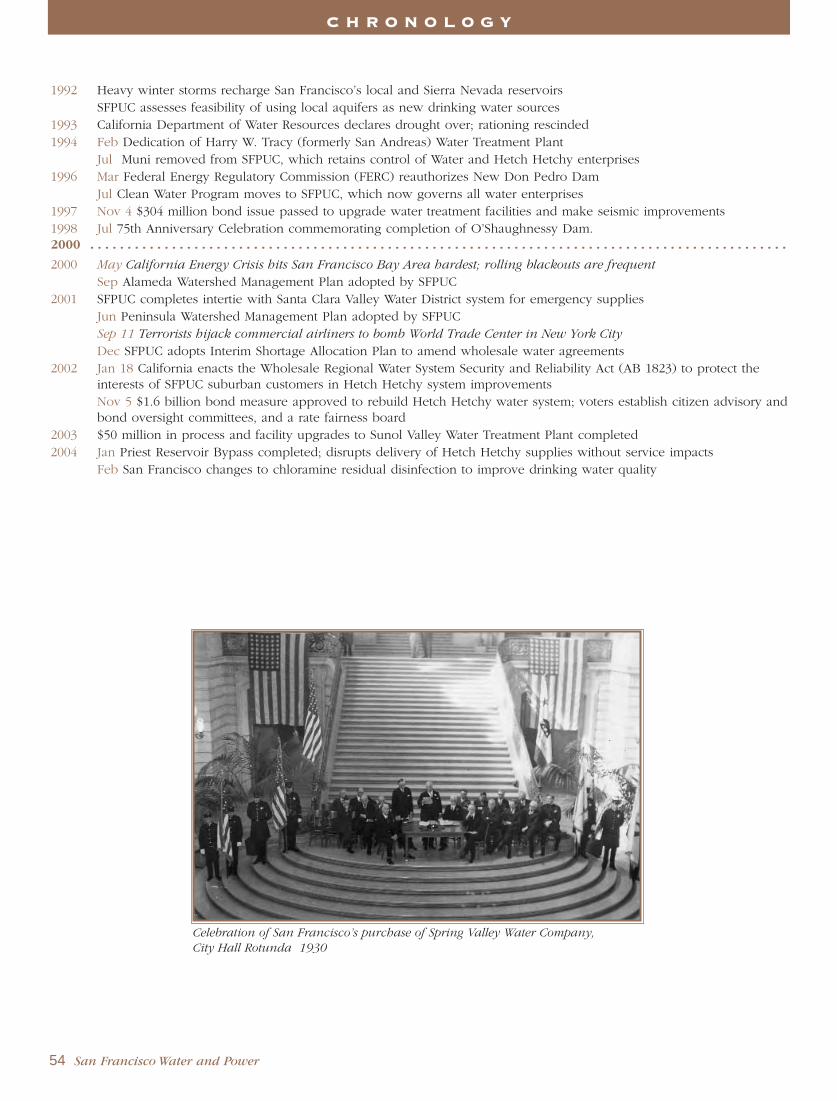
1992 Heavy winter storms recharge San Francisco’s local and Sierra Nevada reservoirs SFPUC assesses feasibility of using local aquifers as new drinking water sources
1993 California Department of Water Resources declares drought over; rationing rescinded1994 Feb Dedication of Harry W. Tracy (formerly San Andreas) Water Treatment Plant
Jul Muni removed from SFPUC, which retains control of Water and Hetch Hetchy enterprises1996 Mar Federal Energy Regulatory Commission (FERC) reauthorizes New Don Pedro Dam
Jul Clean Water Program moves to SFPUC, which now governs all water enterprises1997 Nov 4 $304 million bond issue passed to upgrade water treatment facilities and make seismic improvements 1998 Jul 75th Anniversary Celebration commemorating completion of O’Shaughnessy Dam.2000 . . . . . . . . . . . . . . . . . . . . . . . . . . . . . . . . . . . . . . . . . . . . . . . . . . . . . . . . . . . . . . . . . . . . . . . . . . . . . . . . . . . . . . . . . . . . . .
2000 May California Energy Crisis hits San Francisco Bay Area hardest; rolling blackouts are frequent
Sep Alameda Watershed Management Plan adopted by SFPUC2001 SFPUC completes intertie with Santa Clara Valley Water District system for emergency supplies
Jun Peninsula Watershed Management Plan adopted by SFPUCSep 11 Terrorists hijack commercial airliners to bomb World Trade Center in New York City
Dec SFPUC adopts Interim Shortage Allocation Plan to amend wholesale water agreements 2002 Jan 18 California enacts the Wholesale Regional Water System Security and Reliability Act (AB 1823) to protect the
interests of SFPUC suburban customers in Hetch Hetchy system improvementsNov 5 $1.6 billion bond measure approved to rebuild Hetch Hetchy water system; voters establish citizen advisory andbond oversight committees, and a rate fairness board
2003 $50 million in process and facility upgrades to Sunol Valley Water Treatment Plant completed2004 Jan Priest Reservoir Bypass completed; disrupts delivery of Hetch Hetchy supplies without service impacts
Feb San Francisco changes to chloramine residual disinfection to improve drinking water quality
54 San Francisco Water and Power
C H R O N O L O G Y
Celebration of San Francisco’s purchase of Spring Valley Water Company,
City Hall Rotunda 1930

San Francisco City Water Company General Managers1858 - 1860 Alexei Waldemar von Schmidt
Spring Valley Water Works General Managers1860 - 1864 Alexei Waldemar von Schmidt1864 - 1866 Calvin Brown1866 - 1909 Hermann Schussler1911 - 1914 Fred C. Herrmann1914 - 1930 George A. Elliott
San Francisco Water Department General Managers1930 - 1948 Nelson A. Eckart1949 - 1957 George W. Pracy1957 - 1963 James H. Turner1963 - 1965 Oral L. Moore
H. Christopher Medbery 1965 - 1976 Arthur H. Fry, Jr.1976 - 1978 Kenneth R. Boyd1978 - 1984 Eugene J. Kelleher1984 - 1985 Arthur Jensen (Acting)1985 - 1986 Dean W. Coffey1986 - 1989 James D. Cooney1989 - 1990 Arthur Jensen (Acting)1990 - 1999 John P. Mullane
San Francisco Water EnterpriseAssistant General Managers2005 - Michael Carlin
San Francisco Power EnterpriseAssistant General Managers2005 - Barbara Hale
Hetch-Hetchy Water and PowerGeneral Managers1912 - 1932 Michael M. O’Shaughnessy1932 - 1942 Lloyd T. McAfee1942 - 1945 James H. Turner1945 - 1952 Axel O. Olson1952 - 1961 Harry E. Lloyd1961 - 1979 Oral L. Moore1979 - 1985 Dean W. Coffey1985 - 1986 Theodore L. Chung (Acting)1986 - 1988 Dean W. Coffey1988 - 1993 Anson B. Moran1993 - 2000 Lawrence T. Klein2000 - 2001 Laurie Park (Acting)2002 - 2004 Marla Jurosek & Don Larramendy (Acting)2005 - Don Larramendy
San Francisco Public Utilities CommissionGeneral Managers1932 - 1945 Edward G. Cahill1945 - 1956 James H. Turner1956 - 1958 T. N. Bland1959 - 1964 Robert C. Kirkwood1964 - 1970 James K. Carr1970 - 1976 John D. Crowley1977 - 1979 John B. Wentz1979 - 1983 Richard Sklar1983 - 1986 Rudolf Nothenberg1986 - 1988 Donald J. Birrer1988 - 1989 Dean W. Coffey1989 - 1993 Thomas J. Elzey1993 - 2000 Anson B. Moran2000 - 2001 John P. Mullane2001 Lawrence Klein (Acting)2001 Steven Leonard (Acting) 2001 - 2004 Patricia E. Martel2004 - Susan Leal
G E N E R A L M A N A G E R S
San Francisco Water and Power 55
San Francisco supervisors visit the Sierra Nevada 1917

San Francisco Water and Power by Warren D. Hanson, 1985Subsequent editions: 1987, 1994, 1999, 2002 and 2005
Mr. Hanson wished to acknowledge former San Francisco Public Utilities Commission employees James H. Leonard and TedWurm for their careful and attentive editing of the 1967 and 1979 editions, and to draw the reader’s attention to Mr. Wurm’sHetch Hetchy and its Dam Railroad (Howell-North Books: 1973 et seq) as a valuable reference.
Additional sources include:
San Francisco Water, published quarterly 1922 - 1930 by Spring Valley Water Company, Edward F. O’Day, editor.
San Francisco Water and Power, published for the San Francisco Public Utilities Commission by the Bureau ofEngineering, 1935 and 1947.
Annual reports of the Bureau of Engineering, Board of Public Works, 1908 - 1932.
San Mateo County Historical Association, College of San Mateo.
Society of California Pioneers.
Congressional Record - 1893/1894; 1899/1900; 1912/1913.
“Hetchy” by R. W. Taylor.
“The Top of the Peninsula.” by Marianne Babsal (Historic Resource Study, Golden Gate National Recreation Area,National Park Service, 1990).
History of California, Hubert Howe Bancroft, 1963-1970.
Yosemite’s Hetch Hetchy Railroad, Ted Wurm (Stauffer Publishing: 1990, 4th ed., rev.)
Annual Reports of the San Francisco Water Department.
Annual Reports of the San Francisco Public Utilities Commission.
Municipal Reports, 1850-75.
Of special and valued assistance was Gladys Hansen, former Curator of the San Francisco Room at the San Francisco MainLibrary, to whom the author and editors owe a deep debt of personal gratitude. Ms. Hansen’s reseach into the true number ofcasualties from the 1906 Great Earthquake and Fire is invaluable to San Francisco’s history.
Anne Milner and Franz Hansell contributed to updating the 1994 edition of San Francisco Water and Power.
For the 1999 edition, the editors wish to acknowledge the special contributions of San Francisco Public Utilities GeneralCounsel Thomas M. Berliner and Deputy City Attorney Joshua D. Milstein in reorienting the text chronologically to unfold thecompelling story of San Francisco’s search for water and the landmark Hetch Hetchy building program. Thanks to the firmJRP Historical Consulting, Inc. for reviewing the text for accuracy.
The 2005 edition contains significant revisions by editors Frank Kukula, Christopher Nelson and Mary Williams to update thetext and photographs. They wish to acknowledge the special contributions of Photography Archive Librarian Katherine duTiel for her zeal in locating new historical photographs; Hetch Hetchy Water & Power archive librarians Claudia Day andKatherine Jose for their diligent research; and senior operations managers in the San Francisco Public Utilities Commissionwater and power enterprises for their careful review of new inclusions to the text.
The editors gratefully acknowledge Mimi Chu Reyes, a superb graphic designer, who is responsible for the new look of this2005 edition.
PHOTO CREDITS:Front cover photo: O’Shaughnessy Dam and Hetch Hetchy ReservoirPage 1: San Andreas Reservoir and WatershedPage 19: Headwaters of Tuolumne River in winterPage 28: O’Shaughnessy Dam and Hetch Hetchy Reservoir 1926Page 48: Hetch Hetchy Railroad snowplow 1932
Unless otherwise credited, photography is by the San Francisco Public Utilities Commission. Undated photographs are recent.
A C K N O W L E D G E M E N T S
© SFPUC Communications 2005