sandag first and last mile solutions for transit · pdf filesandag first and last mile...
TRANSCRIPT


SANDAG First and Last Mile Solutions for Transit Centers
Project Report
October 2011
Prepared for:
San Diego Association of Governments (SANDAG)
Prepared by:


SANDAG First and Last Mile Solutions for Transit Centers
Project Report
i October 2011
Table of Contents
1 INTRODUCTION/PURPOSE ...................................................................................................................... 1
2 STUDY APPROACH .................................................................................................................................. 2
3 STATION SELECTION ............................................................................................................................... 3 3.1 CANDIDATE STATIONS AND STATION SELECTION APPROACH ............................................................................... 3 3.2 INITIAL STATION SCREENING ......................................................................................................................... 5 3.3 NARROWED SET OF STATIONS EVALUATION .................................................................................................. 10 3.4 STATION SELECTION RESULTS ..................................................................................................................... 11 3.5 SELECTED STATIONS – SITE VISITS ............................................................................................................... 16
4 SOLUTION OPTIONS .............................................................................................................................. 24 4.1 COMPREHENSIVE LIST OF POTENTIAL STATION ACCESS SOLUTIONS .................................................................... 25 4.2 SCREENED SOLUTIONS AND OPPORTUNITY IDENTIFICATION .............................................................................. 25
5 STAKEHOLDER INPUT ............................................................................................................................ 38 5.1 INTERCEPT AND WEB SURVEYS ................................................................................................................... 38 5.2 RESULTS AND CONCLUSIONS ...................................................................................................................... 40
6 FIRST AND LAST MILE SOLUTIONS RECOMMENDATIONS ...................................................................... 42 6.1 KEARNY MESA TRANSIT CENTER LAST MILE SOLUTION RECOMMENDATIONS ....................................................... 42 6.2 32ND & COMMERCIAL STATION FIRST MILE SOLUTION RECOMMENDATIONS ...................................................... 46
7 FIRST MILE AND LAST MILE STRATEGY AND IMPLEMENTATION GUIDE ................................................ 47 7.1 PURPOSE OF THIS GUIDE ........................................................................................................................... 47 7.2 PROGRAM BACKGROUND .......................................................................................................................... 47 7.3 PROGRAM OBJECTIVES .............................................................................................................................. 48 7.4 OPPORTUNITIES AND BENEFITS ................................................................................................................... 48 7.5 STRATEGIC FRAMEWORK FOR ENGAGING EMPLOYERS ..................................................................................... 49 7.6 LAST MILE SOLUTIONS AND PARTNERSHIP IMPLEMENTATION OPTIONS .............................................................. 56
APPENDICES A. NARROWED SET OF STATIONS EVALUATION B. LIST OF IDENTIFIED STAKEHOLDER GROUPS AND CONTACTS
B1. Kearny Mesa Transit Center B2. 32nd & Commercial Station
C. SURVEY QUESTIONNAIRES C1. Intercept Survey Questionnaires C2. Web-based Survey Questionnaires

SANDAG First and Last Mile Solutions for Transit Centers
Project Report
ii October 2011
Figures
FIGURE 1: COMPREHENSIVE STATION AND TRANSIT CENTER LOCATIONS ........................................................................ 4 FIGURE 2: STATION SELECTION EVALUATION METHODOLOGY ...................................................................................... 5 FIGURE 3: NARROWED SET OF STATIONS ................................................................................................................. 9 FIGURE 4: KEARNY MESA TRANSIT CENTER AREA .................................................................................................... 16 FIGURE 5: KEARNY MESA TRANSIT CENTER – NEARBY EMPLOYERS, ACTIVITY CENTERS, AND BICYCLE ROUTES .................... 17 FIGURE 6: 32ND & COMMERCIAL STATION AREA .................................................................................................... 19 FIGURE 7: 32ND & COMMERCIAL STATION AREA – NEARBY BICYCLE ROUTES .............................................................. 20 FIGURE 8: FIRST AND LAST MILE SOLUTIONS IDENTIFICATION, SCREENING, AND RECOMMENDATION PROCESS .................... 24 FIGURE 9: PLANNED I-15 BRT SERVICE TO KEARNY MESA TRANSIT CENTER ................................................................. 50 FIGURE 10: STRATEGIC FRAMEWORK APPROACH ...................................................................................................... 54 FIGURE 11: KEARNY MESA TRANSIT CENTER SHUTTLE ROUTES .................................................................................... 57
Tables
TABLE 1: FEEDER-BUS PEAK-PERIOD SERVICE FREQUENCY TO STATIONS SUMMARY ........................................................... 7 TABLE 2: NARROWED SET OF STATIONS FOR FURTHER EVALUATION ................................................................................ 8 TABLE 3: NARROWED SET OF STATIONS EVALUATION: SUMMARY OF EVALUATION ........................................................... 13 TABLE 4: KEARNY MESA TRANSIT CENTER AND 32ND & COMMERCIAL STATION SITE VISITS – ACCESS BARRIER OBSERVATIONS
AND FINDINGS ........................................................................................................................................ 21 TABLE 5: COMPREHENSIVE LIST OF FIRST AND LAST MILE SOLUTIONS ............................................................................ 26 TABLE 6: KEARNY MESA TRANSIT CENTER STATION KEY SURVEY FINDINGS ..................................................................... 40 TABLE 7: 32ND & COMMERCIAL STATION KEY SURVEY FINDINGS .................................................................................. 40 TABLE 8: KEARNY MESA TRANSIT CENTER AREA EMPLOYERS/STAKEHOLDERS.................................................................. 52
SANDAG First and Last Mile Solutions for Transit Centers
Project Report
1 October 2011
1 Introduction/Purpose
The San Diego region has a well-developed transit system that carries over 334,000 passenger trips a
day on fixed-route bus and rail services.1 The system is composed of almost 40 miles of commuter
rail along the coast (COASTER), more than 75 miles of light rail on four lines (three San Diego Trolley
routes and the SPRINTER in North County), four Premium Express Bus services along the I-15
Express Lanes, and a network of local bus routes serving key transit centers. There are 73 rail
stations, four Premium Express Bus stations, and nine bus-only transit centers in the region that
create the backbone of the transit system.
However, access to and from rail and Premium Express Bus stations and transit centers is often a
challenge and can be a barrier to transit use for many potential riders. For many trips, transit stations
are located just beyond practical walking distance to and from home or work, sidewalks and bike
paths connecting with the stations are intermittent, insecure, or non-existent, and/or motorized
access options such as feeder buses, shuttles, shared rides, and parking are limited or unavailable.
This access deficiency between the transit station and the trip origin-destination is referred to as the
first mile/last mile gap and is often cited as the reason more people do not ride transit. Transit can
get riders close but not close enough for many trips.
The San Diego Association of Government’s (SANDAG) goal is to increase transit accessibility and
ridership by improving access to and from stations. To move toward this goal, SANDAG has
undertaken this First Mile and Last Mile Solutions for Transit Centers study to identify potential pilot
projects that would bridge the access gap between home and the transit station (first mile), and
between the transit station and work (last mile). To undertake this study, SANDAG applied for and
received a Caltrans Planning Grant to:
“identify major transit hubs along regional rail lines and bus rapid transit routes and
formulate recommendations to optimize feeder services to and from these hubs.
Possible feeder services could include any number or combination of walking, bicycling, carpools, vanpools, carsharing, vansharing, bus shuttles, paratransit or
other alternatives. The goal is to address barriers to taking transit by identifying station-specific solutions that increase the attractiveness of transit to a wider range
of users.”2
Key objectives of the study and pilot project include:
Identify the Strongest Station Area Markets – Identify one or two stations for
implementation of a first mile/last mile pilot project. Selected stations could be appropriate for a
first mile solution (high propensity for home-to-station trips) or a last mile solution (high
propensity for station-to-work trips), or both.
Permit Short-Term Implementation – Define a pilot project(s) that has relatively low capital
cost, does not require land use changes, and is easy to implement so that success can be
demonstrated in a short time frame.
1 pcp.sandag.org (SANDAG Passenger Counts, FY2010). 2 FY2009–10 Community-Based Transportation Planning Application – First and Last Mile Solutions for Transit
Centers, SANDAG.

SANDAG First and Last Mile Solutions for Transit Centers
Project Report
2 October 2011
Require Little/No Operating Subsidy – Define a pilot project(s) that is sustainable over the
long term and requires little or no ongoing public operating subsidy.
Focus on Commute Trips – Focus the pilot project(s) on peak periods and commute trips
when most transit ridership occurs.
Seek Private Partnerships – Consider partnerships with employers, homeowners associations,
and property managers to implement and support the pilot project(s), if possible.
Obtain Stakeholder Input – Incorporate stakeholder (employee/employer, resident/
community group) input into selection and development of the pilot project(s).
The study and resulting pilot project fall under the responsibility of the SANDAG Transportation
Demand Management Division, referred to as iCommute program. The goal of the iCommute
program is to reduce traffic congestion during peak-times, as well as reduce greenhouse gas
emissions and other environmental pollutants that result from commuters driving to work each day.
iCommute assists commuters by providing free carpool and ridematching services, a subsidized
vanpool program, transit solutions, regional support for bicycling, and other services and programs.3
Incorporating first mile/last mile station access solutions into its menu of program options is
consistent with iCommute’s goals and supports SANDAG’s 2050 Regional Transportation Plan mobility
policies and transit network.
2 Study Approach
The First Mile and Last Mile Solutions for Transit Centers study was undertaken in five steps, each of
which is described and discussed in detail in the following sections of this report:
Section 3: Station Selection – A complete analysis of the 86 commuter rail, light rail, Premium
Express Bus stations and transit centers was conducted to identify stations for implementation of
a first or last mile pilot project. Evaluation and selection criteria, discussed in detail in Section 3,
focused on the extent of the potential, untapped transit-ridership market near each station
(population and employment), and the relative ease or difficulty in accessing each station
(available services, infrastructure and facilities). The analysis identified two stations—the Kearny
Mesa Transit Center and the 32nd & Commercial Station—to carry into the next steps. Field
surveys in the two selected station areas resulted in an inventory of observed barriers to access
to the stations.
Section 4: Solution Options – A comprehensive identification of station access solutions was
developed and each potential solution defined to establish a universe of options for consideration.
Based on the Barriers to Access Observations and Findings inventory for each selected station,
the solution options were screened to create a narrowed list of potential solutions that could
address the access barriers of the two selected stations and would meet SANDAG’s study goals.
Section 5: Stakeholder Input – Input from transit riders, residents, and employees in the
selected station areas was obtained through station intercept surveys and Web-based surveys.
3 www.icommutesd.com/about
SANDAG First and Last Mile Solutions for Transit Centers
Project Report
3 October 2011
Through the surveys, residents and employees were asked about access barriers between their
homes (or work sites) and the transit stations and to identify improvements that would enhance
their access and/or encourage them to use transit. In addition to the resident and employee
surveys, SANDAG conducted meetings with several interested individuals and employers to delve
into more details regarding the barriers and opportunities identified through the surveys. The
survey and meeting results were used to develop the most promising first and last mile solutions
at each station.
Section 6: First and Last Mile Solutions Recommendations – Using the Barriers to Access
Observations and Findings inventory for each station, the narrowed list of potential solutions, and
the stakeholder input, a screened list of physical enhancements and capital projects to improve
first and/or last mile access to the two selected stations was identified. In addition, motorized
solution options were identified for the Kearny Mesa Transit Center to be implemented in
partnership with station area employers.
Section 7: First Mile and Last Mile Strategy and Implementation Guide – The study
concludes with a Strategy and Guide for Engaging Employers as Partners in Implementing Last
Mile Transit Solutions for the Kearny Mesa Transit Center. This guide includes strategies for
engaging employers as partners to implement motorized solutions, and associated
implementation requirements, partnership structures, SANDAG and employer roles and
responsibilities, and order-of-magnitude capital and/or operating costs for implementing a pilot
project.
3 Station Selection
3.1 Candidate Stations and Station Selection Approach
The 73 rail stations, four Premium Express Bus stations, and nine bus-only transit centers provide
passenger access to services that create the backbone of the region’s transit system. COASTER
commuter rail extends approximately 40 miles between the Oceanside Transit Center in north San
Diego County and downtown San Diego, stopping at eight stations along the route. The San Diego
Trolley light rail system includes 53 miles of track along the Blue, Orange, and Green Lines, serving
south, east, and central San Diego, respectively. There are a combined 53 trolley stations on the
three routes. SPRINTER light rail includes 15 stations along 22 miles of track between the Oceanside
Transit Center on the west and the Escondido Transit Center on the east. And four peak-period
Premium Express Bus routes currently travel along the I-15 Express Lanes between downtown San
Diego and points north, serving four stations in Sabre Springs, Rancho Bernardo, and two in
Escondido. A new all-day I-15 Bus Rapid Transit (BRT) route between downtown San Diego and
Escondido via Mid-City will begin service in 2013 and will stop at the Kearny Mesa Transit Center. The
BRT will operate in both directions every 15 minutes during the peak periods and every 30 minutes
during off-peak periods and evenings. All commuter rail, light rail, Premium Express Bus, and future
BRT stations and transit centers in the region were considered candidates for first and last mile
solutions since they provide the primary access points to the region’s backbone transit system.
Figure 1 displays the region’s rail and Premium Express Bus stations and transit centers.

SANDAG First and Last Mile Solutions for Transit Centers
Project Report
4 October 2011
Figure 1: Comprehensive Station and Transit Center Locations

SANDAG First and Last Mile Solutions for Transit Centers
Project Report
5 October 2011
To identify two stations for development of first and/or
last mile solutions and potential pilot project
implementation, a two-step station selection evaluation
methodology was used. The first step included an initial
screening of the comprehensive list of candidate stations
identified previously, using criteria that screened out
stations with high levels of existing feeder bus service—a
criterion determined to indicate that the station already
has good first and last mile access. The second step
further evaluated the narrowed set of candidate stations,
using population and employment criteria that portray the
extent of the potential transit-ridership market near each
station, and additional criteria to assess the availability
and use of existing services, infrastructure, and facilities
that provide and promote access to and from the station.
Figure 2 graphically displays the station selection
evaluation methodology.
3.2 Initial Station Screening
The initial screening criteria evaluated existing feeder
transit access to each of the stations in the comprehensive
list of candidate stations shown in Figure 2. Stations with
high levels of existing feeder bus service during the peak
hour were considered to have well-served first and last
mile access. As a result, they were deemed to be poorer
candidates for first and last mile solutions. The number
and frequency of routes serving each station during the
peak hour and each route’s peak-hour frequency were
used to calculate the number of peak-hour feeder bus
trips serving each station. The peak hour was used as a
proxy for the entire peak period, which reflects the
commute trip focus of the study.
This initial screening approach eliminated the following
stations from further consideration:
High Feeder-Bus Service Stations – Stations that have more than 20 feeder bus trips per
peak hour were eliminated from further consideration because these stations already have good
first/last mile access.
All Downtown Stations – Stations in downtown San Diego and at the edge of downtown have
geographically small and overlapping station-access areas and are set in a dense and highly
walkable and transit accessible environment. As a result, they are not good candidates for a first
and last mile solution pilot project.
Unique Stations – The following five stations were eliminated from further consideration
because each has unique characteristics that would interfere with the ability to transfer a
successful pilot project application to other stations:
Figure 2: Station Selection
Evaluation Methodology

SANDAG First and Last Mile Solutions for Transit Centers
Project Report
6 October 2011
San Ysidro Transit Center (San Diego Trolley Blue Line) – This station serves a large cross-
border travel demand and unique trip purpose and market demographic that is not found
elsewhere in the region.
Qualcomm Stadium Station (San Diego Trolley) – This station is primarily a special-event
station. While this station does provide park-and-ride access for commuters, its location
within the 18,000-space stadium parking lot makes applicability of a pilot project solution to
other stations in the future more difficult.
Sorrento Valley Station (COASTER) – This station has the most extensive station-to-
employment site shuttle system in the region. The publicly and privately provided shuttles
are timed to meet the trains in the mornings and evenings and directly serve major
employment sites. In a sense, the station is already an example of a successful but highly
subsidized (for the public shuttles) first and last mile solution.
Pacific Fleet/32nd Street and Harborside/28th Street Stations (San Diego Trolley Blue Line) –
These two stations were eliminated because major employers (National Steel and
Shipbuilding and the U.S. Navy) are located within walking distance of these stations, which
greatly reduces the need for a first or last mile connection.
Table 1 summarizes the peak-hour feeder-bus frequency at each of the stations and initial screening
conclusions. The route and frequency service details for each station are included in Appendix A.
Although the more than 20 bus trips per hour that currently serve the Kearny Mesa Transit Center
would eliminate it under the screening criteria, SANDAG chose to move this station forward for
further evaluation for the following reasons:
There are a large number of major employers located in the vicinity of the transit center station
but off the major arterials where existing bus routes serving the station operate;
The potential partnership opportunities for last mile solutions presented by the presence of these
employers; and
The planned, new, all day I-15 BRT route that will serve the transit center beginning in 2013.
The narrowed set of 46 stations carried forward for further evaluation are shown by associated rail or
Premium Express Bus route in Table 2 and Figure 3.

SANDAG First and Last Mile Solutions for Transit Centers
Project Report
7 October 2011
Table 1: Feeder-Bus Peak-Period Service Frequency to Stations Summary
Feeder Bus Trips/Peak Hour
41+ 31–40 21–30 11–20 0–10
Iris Avenue El Cajon TC 8th Street San Ysidro Beyer
Old Town TC Fashion Valley TC La Mesa Blvd Palm Ave Pacific Fleet/32nd/Street
Euclid TC El Cajon Blvd Transit Plaza Oceanside TC Palomar Harborside/28th Street
SDSU TC Kearny Mesa TC* Vista TC H Street Barrio Logan
Escondido TC
Mira Mesa Bayfront/E Street Middletown
City Heights Transit Plaza
24th Street Washington Street
All Downtown Stations Encanto Cesar Chavez/25th Street
Amaya 32nd Street/Commercial
Santee Town Center 47th Street
Grantville Massachusetts
Encinitas Lemon Grove
Carlsbad Poinsettia Spring Street
Palomar College Grossmont
Sabre Springs Arnelle
Rancho Bernardo Gillespie
Morena/Linda Vista
Hazard Center
Mission Valley Center
Rio Vista
Qualcomm
Fenton
Mission San Diego
Alvarado
70th Street
Sorrento Valley
Solana Beach
Carlsbad Village
Coast Highway
Crouch
El Camino Real
Rancho del Oro
College Blvd
Melrose
Escondido Ave
Buena Creek
Civic Center-San Marcos
Cal State San Marcos
Nordahl
Del Lago
Stations Retained for Further Consideration Stations Eliminated During Initial Screening High Feeder Bus Service to Station * Retained because of opportunities presented by nearby large employers and planned BRT. Unique Stations
Downtown & Downtown Edge Stations

SANDAG First and Last Mile Solutions for Transit Centers
Project Report
8 October 2011
Table 2: Narrowed Set of Stations for Further Evaluation
San Diego Trolley
SPRINTER COASTER I-15 Premium Express
Bus Blue Line Green Line Orange Line
Beyer Blvd Santee Town Center Coast Highway Carlsbad Village Sabre Springs
Palm Avenue Gillespie Field Crouch Street Carlsbad Poinsettia Rancho Bernardo
Palomar Street Arnele Avenue El Camino Real Encinitas Del Lago
H Street Amaya Drive Rancho Del Oro Solana Beach Kearny Mesa Transit Center*
Bayfront/E Street Grossmont Transit Center College Blvd
24th Street 70th Street Station Spring Street Station Escondido Avenue
Morena/Linda Vista Lemon Grove Melrose
Hazard Center Massachusetts Ave Buena Creek
Mission Valley Center Encanto/62nd Street Palomar College
Rio Vista 47th Street San Marcos Civic Center
Fenton 32nd St/Commercial Cal State San Marcos
Mission San Diego Nordahl
Grantville
Alvarado
* Future I-15 BRT Station for service opening in 2013.

SANDAG First and Last Mile Solutions for Transit Centers
Project Report
9 October 2011
Figure 3: Narrowed Set of Stations

SANDAG First and Last Mile Solutions for Transit Centers
Project Report
10 October 2011
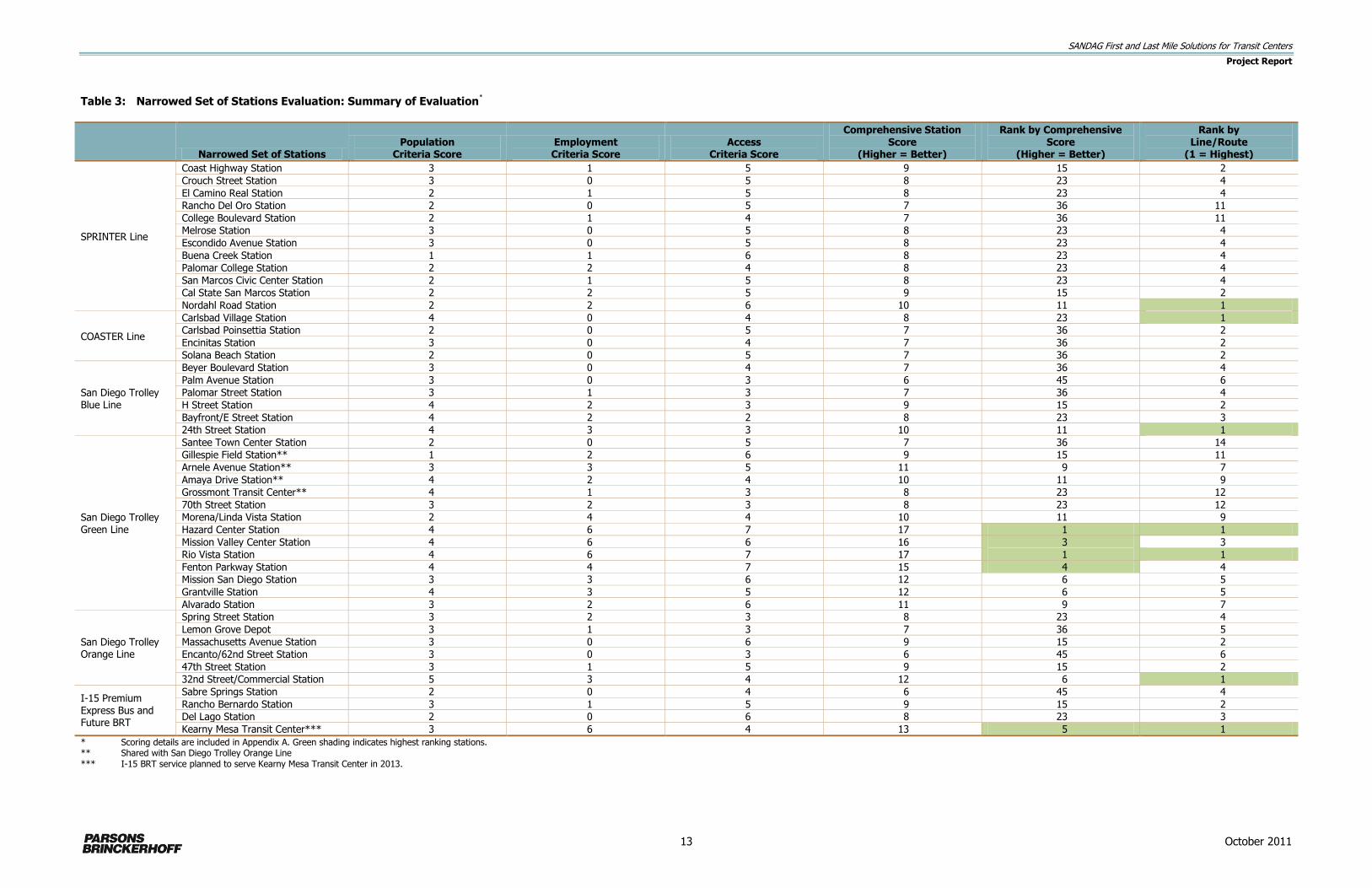
3.3 Narrowed Set of Stations Evaluation
The best candidates for first and last mile solutions are those stations that have relatively dense
population and/or employment, supportive population and/or employment demographics, and poor
existing access. As a result, the evaluation of the narrowed set of stations focused on three key
factors:
Population characteristics near the station
Employment characteristics near the station
Access opportunities near the station
Within each of these categories, the following specific criteria were used to conduct the station
evaluation:
Population Characteristics Criteria (applicable to first mile stations)
Population density (population/acre within 2 miles of station) – Stations with higher
population densities make better candidates for first and last mile solutions because they
offer a concentrated, potentially latent transit market.
Employed population (employees/acre within 2 miles of station) – Stations with higher
employed populations are better candidates for first and last mile solutions because they
offer a concentrated, potentially latent transit market.
Percentage of household auto ownership (within 2 miles of station) – Stations with a higher
percentage of households with low auto ownership are better candidates for first and last
mile solutions because they require more need for non-auto alternatives to access the
station.
Employment Characteristics Criteria (applicable to last mile stations)
Employment density (employees/acres within 2 miles of station) – Stations with higher
employment densities make better candidates for first and last mile solutions because they
offer concentrated, potentially latent transit market.
Major employers (within 1 mile of station) – Stations with a higher number of large nearby
employers are better candidates for first and last mile solutions because they present
concentrations of employees in one location and solution implementation partnering
opportunities.
Major employers (within 3 miles of station) – Stations with a higher number of large
employers in an expanded vicinity are better candidates for first and last mile solutions
because they present concentrations of employees in one location and solution
implementation partnering opportunities.
Access Opportunities Criteria
Motorized access (feeder bus and/or park and ride availability) – Stations having little or no
feeder bus service or park and ride availability are better candidates for first/last mile
solutions because access options are currently limited.
Pedestrian access (number of intersections within ½ mile of station) – The number of
intersections in the vicinity of the station was used as a proxy for an accessible street

SANDAG First and Last Mile Solutions for Transit Centers
Project Report
11 October 2011
network and pedestrian paths. Stations with fewer intersections in the vicinity are better
candidates for first and last mile solutions because they have limited street and pedestrian
interconnecting networks.
Bicycle access (linear mileage of Class I, II, III, and IV bike routes within 2 miles of station) –
Stations with fewer miles of bicycle routes are better candidates for first/last mile solutions
because they have limited bicycle access networks.
Transit ridership (AM and PM peak ridership at station) – Stations with lower transit ridership
are better candidates for first and last mile solutions because low ridership may indicate
existing barriers to station access.
Based on the data range within each criterion, high, medium, and low sub-range values were applied
(score values: high = 2, medium = 1, low = 0) for each station. Scores were totaled by category
(population, employment, access), and those totals were combined to create a comprehensive score
for each station. The higher the score, the better candidate the station was for a first or last mile
solution. Table 3 provides the total scores for each criterion and the comprehensive station scores for
the narrowed set of stations. Appendix A provides the evaluation and scoring details.
3.4 Station Selection Results
Based on the evaluation, the five highest-ranked stations are:
Hazard Center Station
Mission Valley Center Station
Rio Vista Station
Fenton Parkway Station
Kearny Mesa Transit Center
The top-ranked stations on each rail or Premium Express Bus line are:
Nordahl Road Station (SPRINTER)
Carlsbad Village Station (COASTER)
24th Street Station (San Diego Trolley Blue Line)
Hazard Center and Rio Vista Stations – tied (San Diego Trolley Green Line)
32nd and Commercial Street Station (San Diego Trolley Orange Line)
Kearny Mesa Transit Center (future I-15 BRT line)
These top-ranked stations are highlighted in green in Table 3.

SANDAG First and Last Mile Solutions for Transit Centers
Project Report
12 October 2011
THIS PAGE LEFT BLANK INTENTIONALLY.
SANDAG First and Last Mile Solutions for Transit Centers
Project Report
13 October 2011
Table 3: Narrowed Set of Stations Evaluation: Summary of Evaluation*
Narrowed Set of Stations
Population Criteria Score
Employment Criteria Score
Access Criteria Score
Comprehensive Station Score
(Higher = Better)
Rank by Comprehensive Score
(Higher = Better)
Rank by Line/Route
(1 = Highest)
SPRINTER Line
Coast Highway Station 3 1 5 9 15 2
Crouch Street Station 3 0 5 8 23 4
El Camino Real Station 2 1 5 8 23 4
Rancho Del Oro Station 2 0 5 7 36 11
College Boulevard Station 2 1 4 7 36 11
Melrose Station 3 0 5 8 23 4
Escondido Avenue Station 3 0 5 8 23 4
Buena Creek Station 1 1 6 8 23 4
Palomar College Station 2 2 4 8 23 4
San Marcos Civic Center Station 2 1 5 8 23 4
Cal State San Marcos Station 2 2 5 9 15 2
Nordahl Road Station 2 2 6 10 11 1
COASTER Line
Carlsbad Village Station 4 0 4 8 23 1
Carlsbad Poinsettia Station 2 0 5 7 36 2
Encinitas Station 3 0 4 7 36 2
Solana Beach Station 2 0 5 7 36 2
San Diego Trolley Blue Line
Beyer Boulevard Station 3 0 4 7 36 4
Palm Avenue Station 3 0 3 6 45 6
Palomar Street Station 3 1 3 7 36 4
H Street Station 4 2 3 9 15 2
Bayfront/E Street Station 4 2 2 8 23 3
24th Street Station 4 3 3 10 11 1
San Diego Trolley Green Line
Santee Town Center Station 2 0 5 7 36 14
Gillespie Field Station** 1 2 6 9 15 11
Arnele Avenue Station** 3 3 5 11 9 7
Amaya Drive Station** 4 2 4 10 11 9
Grossmont Transit Center** 4 1 3 8 23 12
70th Street Station 3 2 3 8 23 12
Morena/Linda Vista Station 2 4 4 10 11 9
Hazard Center Station 4 6 7 17 1 1
Mission Valley Center Station 4 6 6 16 3 3
Rio Vista Station 4 6 7 17 1 1
Fenton Parkway Station 4 4 7 15 4 4
Mission San Diego Station 3 3 6 12 6 5
Grantville Station 4 3 5 12 6 5
Alvarado Station 3 2 6 11 9 7
San Diego Trolley Orange Line
Spring Street Station 3 2 3 8 23 4
Lemon Grove Depot 3 1 3 7 36 5
Massachusetts Avenue Station 3 0 6 9 15 2
Encanto/62nd Street Station 3 0 3 6 45 6
47th Street Station 3 1 5 9 15 2
32nd Street/Commercial Station 5 3 4 12 6 1
I-15 Premium Express Bus and Future BRT
Sabre Springs Station 2 0 4 6 45 4
Rancho Bernardo Station 3 1 5 9 15 2
Del Lago Station 2 0 6 8 23 3
Kearny Mesa Transit Center*** 3 6 4 13 5 1
* Scoring details are included in Appendix A. Green shading indicates highest ranking stations. ** Shared with San Diego Trolley Orange Line *** I-15 BRT service planned to serve Kearny Mesa Transit Center in 2013.

SANDAG First and Last Mile Solutions for Transit Centers
Project Report
14 October 2011
THIS PAGE LEFT BLANK INTENTIONALLY.

SANDAG First and Last Mile Solutions for Transit Centers
Project Report
15 October 2011
After considering the project goals, criteria, and evaluation, SANDAG selected the Kearny Mesa
Transit Center and the 32nd & Commercial Station as the two stations for evaluation and
development of first and last mile access solutions. These stations were selected from among the
topped ranked stations based on the following:
Although they rated high, the stations along the San Diego Trolley Green Line (Hazard, Mission
Valley, Rio Vista and Fenton Stations) are not good candidates for first and last mile solutions
because their location in Mission Valley presents many challenges to the potential success of a
pilot project. The challenges include physical barriers created by the freeway, river and Friars
Road that result in a circuitous and discontinuous street network (poor connectivity), dispersed
and mostly retail (non peak hour) employment, lack of large employers as potential partners, and
the fact that the San Diego Metropolitan Transit System (MTS) has provided shuttles in the past
with minimal success. Mission Valley has good transit infrastructure (trolley) but has particularly
challenging first and last mile issues that would make it difficult to implement solutions relatively
quickly.
The SPRINTER Nordahl Road Station did not warrant much attention in the study for two reasons.
First, the area surrounding it is fairly low density employment. Second and more significantly,
with opening of a new hospital in Escondido, the hospital and the North County Transit District
are partnering to provide a shuttle between the existing hospital in downtown Escondido and the
new hospital site west of I-15 that would also serve the Nordahl SPRINTER Station. This shuttle
will provide a first and last mile solution for the station.
The Carlsbad Village Station was eliminated from further consideration because although it
ranked highest among the COASTER stations evaluated, it ranked much lower among all stations
(23rd) relative to the other topped ranked stations. In addition, the Carlsbad Village Station is
located in an area with low employment density, few large employers nearby, and only moderate
population density.
The population and employment characteristics in the vicinity of the 24th Street Station on the
Trolley Blue Line are very similar to the 32nd & Commercial Station on the Orange Line. Since
32nd & Commercial Station ranked higher, the 24th Street Station was eliminated from further
consideration.
The Kearny Mesa Transit Center was identified by SANDAG as a good candidate for a last mile
solution due to its high employment densities in the vicinity of the station, concentration of large
employers, high transit ridership to the station, and relatively poor station access. Also, several
employers in the area have contacted SANDAG and iCommute in the past about providing
additional help in getting their employees to and from work on transit. Finally, new BRT service
will begin serving the transit center in 2013 providing more opportunity and need for a first and
last mile connection.
The 32nd & Commercial Station on the San Diego Trolley Orange Line was identified as a good
candidate for a first mile solution due to the compact residential nature of the area and the
opportunity to evaluate improved bicycle and pedestrian access in addition to vehicular access
options.

SANDAG First and Last Mile Solutions for Transit Centers
Project Report
16 October 2011
3.5 Selected Stations – Site Visits
The two selected stations’ study areas were defined using physical and geographical boundaries,
freeways, and community planning areas to capture the logical stakeholders and access markets
around each station. Figure 4 depicts the Kearny Mesa Transit Center station area.
Figure 4: Kearny Mesa Transit Center Area
The Kearny Mesa Transit Center study area is bordered by I-805, SR-52, I-15, and Balboa Avenue.
The Kearny Mesa Transit Center itself consists of simple curbside bus stops located along Clairemont
Mesa Boulevard east of Complex Drive and along Complex Drive—south of Clairemont Mesa
Boulevard. Standard bus shelters and benches are located along the typical 5-foot sidewalks
immediately adjacent to streets. Together, these stops create an L-shaped facility that serves bus
routes headed in all directions. Passengers transferring between routes at the Kearny Mesa Transit
Center may be required to cross Complex Drive to access connecting routes. Land uses immediately
adjacent to the transit center consist of low intensity commercial activities (a restaurant, retail shops,
and banks) with parking located between the transit center and the buildings. The County of San
Diego Traffic Court is located across Clairemont Mesa Boulevard from the transit center. As shown in
Figure 5, there are several large employers and business centers within reasonable walking, biking
and shuttle distance from the station, including the County of San Diego, Bridgepoint Education,
Sharp Healthcare, and San Diego Gas & Electric. While there are scattered multi-family residential
complexes within the larger station area, due to its location in one of the region’s largest employment
centers, the Kearny Mesa Transit Center is best suited for last mile solutions that would bridge the
gap for transit riders between the transit center and their employment destinations.

SANDAG First and Last Mile Solutions for Transit Centers
Project Report
17 October 2011
Figure 5: Kearny Mesa Transit Center – Nearby Employers, Activity Centers, and Bicycle Routes

SANDAG First and Last Mile Solutions for Transit Centers
Project Report
18 October 2011
Kearny Mesa Transit Center – Complex Drive Stop
Kearny Mesa Transit Center – Clairemont Mesa Boulevard Stop
Figure 6 shows the 32nd & Commercial Station study
area and Figure 7 displays the nearby bicycle routes.
The 32nd & Commercial Station area is bordered by
the 28th and 30th Streets on the west, I-805 on the
east, SR-94 on the north, and National Avenue on
the south. The defined station area excludes the
neighborhoods to the west (closest to downtown San
Diego) since these neighborhoods have access to
downtown light rail stations and multiple bus routes.
The station is an off-street light rail station located
on a curve with separate passenger platforms to
serve east and westbound trains. Station facilities are minimal and consist of a few benches and no
shelters. A church with a small parking lot is located immediately adjacent to the station on the north
and a fence along the entire southeastern edge of the station separates the station from a large
storage yard. The surrounding community is a mix of commercial/industrial uses, particularly along
Commercial Avenue and older, generally small lot, single-family homes. I-15, which extends through
the station area in a north-south direction, splits the area into west and east sides of the freeway.
There is a Costco and a few larger employers east of I-15 and north of Market Street in the Gateway
Center beyond walking distance of the station, and some smaller industrial businesses north of
Market Street west of I-15 on the edge of a reasonable walking distance from the station. Given that
the character of the neighborhood is largely residential (with smaller industrial employers), the 32nd
& Commercial Station is best suited for first mile solutions that would improve access to transit for
residents of the community.
Site visits to the Kearny Mesa Transit Center and 32nd & Commercial Station areas were conducted
in December 2010 to take an inventory of barriers to access that could guide consideration of first
and last mile solutions. The site visits encompassed the entire area within the defined boundaries of
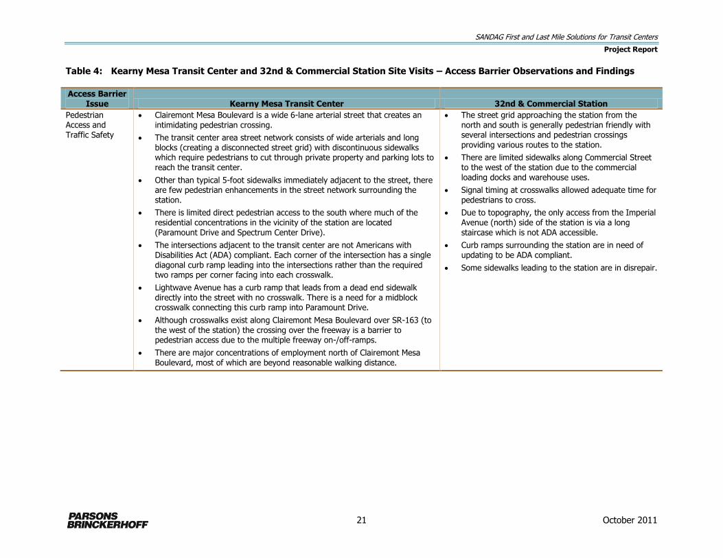
each station area but focused on the more immediate vicinity of the station. Table 4 summarizes the
observations and findings from the station area site visits.
32nd & Commercial Street Station

SANDAG First and Last Mile Solutions for Transit Centers
Project Report
19 October 2011
Figure 6: 32nd & Commercial Station Area

SANDAG First and Last Mile Solutions for Transit Centers
Project Report
20 October 2011
Figure 7: 32nd & Commercial Station Area – Nearby Bicycle Routes
SANDAG First and Last Mile Solutions for Transit Centers
Project Report
21 October 2011
Table 4: Kearny Mesa Transit Center and 32nd & Commercial Station Site Visits – Access Barrier Observations and Findings
Access Barrier Issue Kearny Mesa Transit Center 32nd & Commercial Station
Pedestrian Access and Traffic Safety
Clairemont Mesa Boulevard is a wide 6-lane arterial street that creates an intimidating pedestrian crossing.
The transit center area street network consists of wide arterials and long blocks (creating a disconnected street grid) with discontinuous sidewalks which require pedestrians to cut through private property and parking lots to reach the transit center.
Other than typical 5-foot sidewalks immediately adjacent to the street, there are few pedestrian enhancements in the street network surrounding the station.
There is limited direct pedestrian access to the south where much of the residential concentrations in the vicinity of the station are located (Paramount Drive and Spectrum Center Drive).
The intersections adjacent to the transit center are not Americans with Disabilities Act (ADA) compliant. Each corner of the intersection has a single diagonal curb ramp leading into the intersections rather than the required two ramps per corner facing into each crosswalk.
Lightwave Avenue has a curb ramp that leads from a dead end sidewalk directly into the street with no crosswalk. There is a need for a midblock crosswalk connecting this curb ramp into Paramount Drive.
Although crosswalks exist along Clairemont Mesa Boulevard over SR-163 (to the west of the station) the crossing over the freeway is a barrier to pedestrian access due to the multiple freeway on-/off-ramps.
There are major concentrations of employment north of Clairemont Mesa Boulevard, most of which are beyond reasonable walking distance.
The street grid approaching the station from the north and south is generally pedestrian friendly with several intersections and pedestrian crossings providing various routes to the station.
There are limited sidewalks along Commercial Street to the west of the station due to the commercial loading docks and warehouse uses.
Signal timing at crosswalks allowed adequate time for pedestrians to cross.
Due to topography, the only access from the Imperial Avenue (north) side of the station is via a long staircase which is not ADA accessible.
Curb ramps surrounding the station are in need of updating to be ADA compliant.
Some sidewalks leading to the station are in disrepair.
SANDAG First and Last Mile Solutions for Transit Centers
Project Report
22 October 2011
Table 4: Kearny Mesa Transit Center and 32nd & Commercial Station Site Visits – Access Barrier Observations and Findings
(continued)
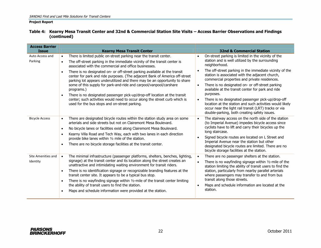
Access Barrier Issue Kearny Mesa Transit Center 32nd & Commercial Station
Auto Access and
Parking
There is limited public on-street parking near the transit center.
The off-street parking in the immediate vicinity of the transit center is associated with the commercial and office businesses.
There is no designated on- or off-street parking available at the transit center for park and ride purposes. (The adjacent Bank of America off-street
parking lot appears underutilized and there may be an opportunity to share some of this supply for park-and-ride and carpool/vanpool/carshare programs.)
There is no designated passenger pick-up/drop-off location at the transit center; such activities would need to occur along the street curb which is used for the bus stops and on-street parking.
On-street parking is limited in the vicinity of the station and is well utilized by the surrounding neighborhood.
The off-street parking in the immediate vicinity of the station is associated with the adjacent church,
commercial properties and private residences.
There is no designated on- or off-street parking available at the transit center for park and ride purposes.
There is no designated passenger pick-up/drop-off location at the station and such activities would likely occur near the light rail transit (LRT) tracks or via double-parking, both creating safety issues.
Bicycle Access There are designated bicycle routes within the station study area on some arterials and side streets but not on Clairemont Mesa Boulevard.
No bicycle lanes or facilities exist along Clairemont Mesa Boulevard.
Kearny Villa Road and Tech Way, each with two lanes in each direction provide bike lanes within ½ mile of the station.
There are no bicycle storage facilities at the transit center.
The stairway access on the north side of the station (to Imperial Avenue) impedes bicycle access since cyclists have to lift and carry their bicycles up the long staircase.
Signed bicycle routes are located on L Street and Imperial Avenue near the station but other designated bicycle routes are limited. There are no bicycle storage facilities at the station.
Site Amenities and
Identity
The minimal infrastructure (passenger platforms, shelters, benches, lighting, signage) at the transit center and its location along the street creates an unattractive and intimidating waiting environment for transit riders.
There is no identification signage or recognizable branding features at the transit center site. It appears to be a typical bus stop.
There is no wayfinding signage within ½-mile of the transit center limiting the ability of transit users to find the station.
Maps and schedule information were provided at the station.
There are no passenger shelters at the station.
There is no wayfinding signage within ½-mile of the station limiting the ability of transit users to find the station, particularly from nearby parallel arterials where passengers may transfer to and from bus transit along those streets.
Maps and schedule information are located at the station.
SANDAG First and Last Mile Solutions for Transit Centers
Project Report
23 October 2011
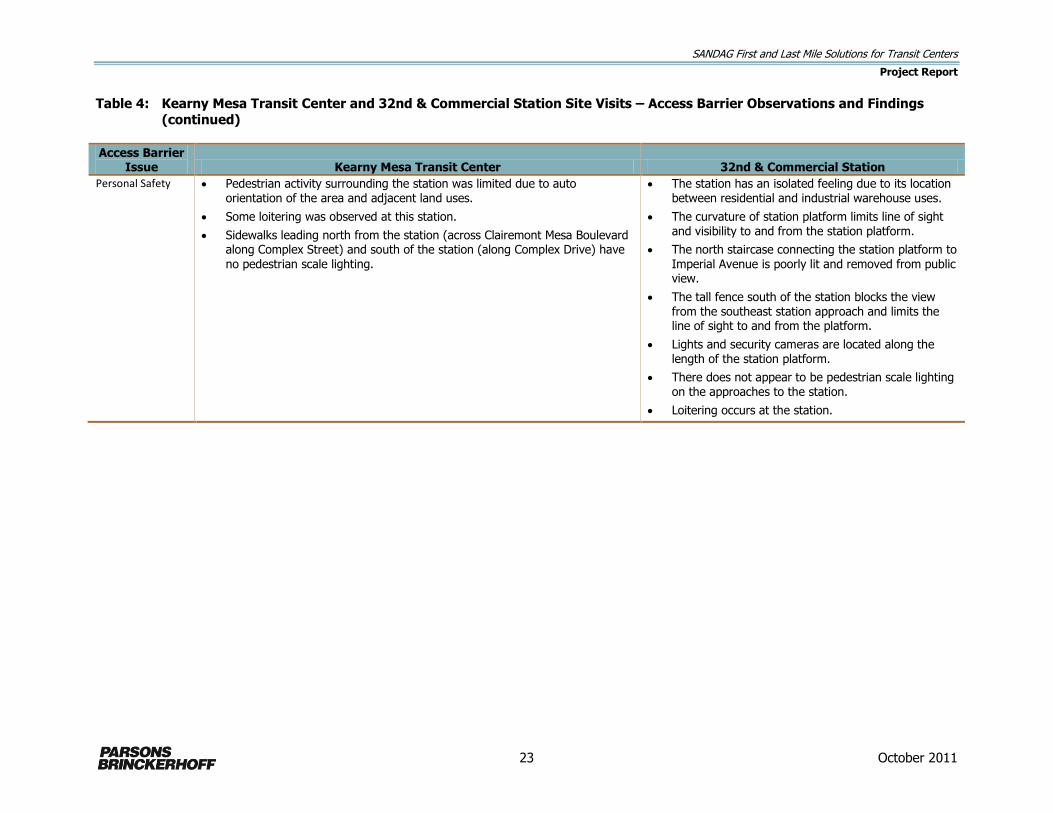
Table 4: Kearny Mesa Transit Center and 32nd & Commercial Station Site Visits – Access Barrier Observations and Findings
(continued)
Access Barrier Issue Kearny Mesa Transit Center 32nd & Commercial Station
Personal Safety Pedestrian activity surrounding the station was limited due to auto orientation of the area and adjacent land uses.
Some loitering was observed at this station.
Sidewalks leading north from the station (across Clairemont Mesa Boulevard along Complex Street) and south of the station (along Complex Drive) have
no pedestrian scale lighting.
The station has an isolated feeling due to its location between residential and industrial warehouse uses.
The curvature of station platform limits line of sight and visibility to and from the station platform.
The north staircase connecting the station platform to
Imperial Avenue is poorly lit and removed from public view.
The tall fence south of the station blocks the view from the southeast station approach and limits the line of sight to and from the platform.
Lights and security cameras are located along the length of the station platform.
There does not appear to be pedestrian scale lighting on the approaches to the station.
Loitering occurs at the station.
SANDAG First and Last Mile Solutions for Transit Centers
Project Report
24 October 2011
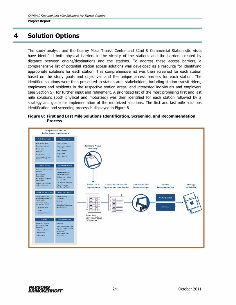
4 Solution Options
The study analysis and the Kearny Mesa Transit Center and 32nd & Commercial Station site visits
have identified both physical barriers in the vicinity of the stations and the barriers created by
distance between origins/destinations and the stations. To address these access barriers, a
comprehensive list of potential station access solutions was developed as a resource for identifying
appropriate solutions for each station. This comprehensive list was then screened for each station
based on the study goals and objectives and the unique access barriers for each station. The
identified solutions were then presented to station area stakeholders, including station transit riders,
employees and residents in the respective station areas, and interested individuals and employers
(see Section 5), for further input and refinement. A prioritized list of the most promising first and last
mile solutions (both physical and motorized) was then identified for each station followed by a
strategy and guide for implementation of the motorized solutions. The first and last mile solutions
identification and screening process is displayed in Figure 8.
Figure 8: First and Last Mile Solutions Identification, Screening, and Recommendation
Process

SANDAG First and Last Mile Solutions for Transit Centers
Project Report
25 October 2011
4.1 Comprehensive List of Potential Station Access Solutions
The comprehensive list of potential first and last mile access solutions was developed as a resource
for identifying appropriate solutions for each station. The comprehensive list of potential solutions is
shown in Table 5.
4.2 Screened Solutions and Opportunity Identification
Comparing the barriers to access observations and findings for each station (Table 4) with the
comprehensive list of potential solutions (Table 5) resulted in screened solutions and identified
opportunities. These screened solutions and identified opportunities were presented to the
stakeholders to develop recommendations for specific solutions for each station. The screened
solutions for each station are listed below.
Kearny Mesa Transit Center Screened Solutions for Further Consideration
Pedestrian Access and Traffic Safety Improvements
Implement traffic calming designs at the intersection of Clairemont Mesa Boulevard and Complex
Drive such as corner bulb-outs, unique crosswalk paving, or other features that would alert
drivers that the intersection exists for pedestrians as well as cars. Traffic volumes on Clairemont
Mesa Boulevard are generally Level of Service (LOS) B or C, indicating that implementing traffic
calming in the area should have minimal impact on traffic capacity.
Widen the sidewalks along Clairemont Mesa Boulevard on the blocks approaching the transit
center.
Upgrade the sidewalks and curb ramps within ¼-mile walking radius of station to meet ADA
standards.
Close gaps in the pedestrian network by completing sidewalks or creating formal pedestrian
paths through private property, particularly to the south from Complex Drive to Paramount Drive
and Spectrum Center Drive.
Auto Access Improvements
Add a passenger drop-off/pick-up zone (kiss-and-ride) at the transit center.
Acquire, though purchase or agreement, parking spaces from adjacent property owners (i.e.,
Bank of America) for last mile carpools/vanpools and commercial carsharing programs.
Bicycle Access Improvements
Provide bicycle storage lockers (possibly located on Bank of America site).
Develop a bikesharing program with nearby employers.
Implement the bikeways identified in SANDAG’s 2050 Regional Bike Plan and the City of San
Diego’s Bicycle Master Plan within 1 mile of the transit center.

SANDAG First and Last Mile Solutions for Transit Centers
Project Report
26 October 2011
Table 5: Comprehensive List of First and Last Mile Solutions
Solution Definition Photo
Pedestrian Access
Curb ramps Perpendicular curb ramps are often installed in pairs at a corner. The level landings of the curb ramps are typically paired with truncated dome tactile strips to provide wayfinding information to people with visual impairments.
Countdown signals Visible and audible signals that countdown, with chirps for people with visual impairments, aid pedestrians to cross the street. Pedestrian signal timing is typically 4 feet per second at a minimum.
Crosswalks Crosswalks are designated pedestrian paths to cross the street safely. They are typically installed at intersections or areas such as near transit stations, where large numbers of pedestrians are attempting to cross.

SANDAG First and Last Mile Solutions for Transit Centers
Project Report
27 October 2011
Table 5: Comprehensive List of First and Last Mile Solutions (continued)
Solution Definition Photo
Pedestrian Access (continued)
Mid-Block Crossings
Midblock crosswalks are typically installed when blocks are more than 600-800 feet on a side. Midblock crosswalks slow down traffic in the immediate vicinity, and they discourage pedestrians from crossing between parked cars. They can be paired with a pedestrian signal and in-pavement
flashing lights.
Sidewalk Width Effective sidewalks are close to 10 feet wide to accommodate pedestrian volumes, passing space, room for wheelchair travel, and “buffer” space (the areas pedestrians avoid near curbs and buildings).
http://photoresearch.beethomas.com/man-in-wheelchair-in-cheynne-wyoming/
Pedestrian Gap Closures Closing gaps within the pedestrian network improves pedestrian access by creating an interconnected network. Gaps may include missing sidewalks, curb ramps, or crosswalks.

SANDAG First and Last Mile Solutions for Transit Centers
Project Report
28 October 2011
Table 5: Comprehensive List of First and Last Mile Solutions (continued)
Solution Definition Photo
Pedestrian Access (continued)
Traffic Calming Traffic calming installations, such as raised crosswalks, are intended to slow or reduce motor-vehicle traffic to improve pedestrian safety.
http://publicworks.kingsporttn.gov/traffic/traffic-calming
Automobile Access
Park and ride parking
Dedicated off-street parking supply for riders within ¼ mile walking distance of the transit station.
http://www.wlabt.com/
Advanced parking reservation systems
Tools that allow customers make parking reservations in advance, or an on-line reservation system. Allows planning for short term daily parking and long term airport parking.
http://www.parkwhiz.com/support/eticket/
SANDAG First and Last Mile Solutions for Transit Centers
Project Report
29 October 2011
Table 5: Comprehensive List of First and Last Mile Solutions (continued)
Solution Definition Photo
Automobile Access (continued)
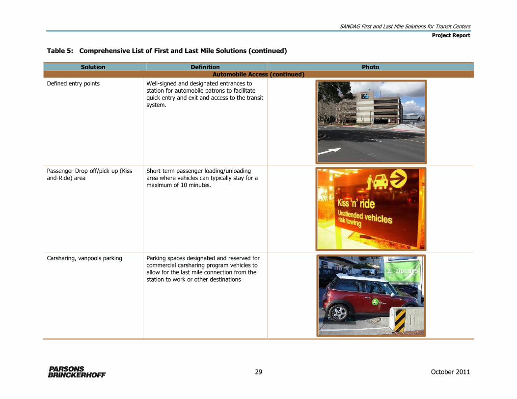
Defined entry points
Well-signed and designated entrances to station for automobile patrons to facilitate quick entry and exit and access to the transit system.
Passenger Drop-off/pick-up (Kiss-and-Ride) area
Short-term passenger loading/unloading area where vehicles can typically stay for a maximum of 10 minutes.
Carsharing, vanpools parking
Parking spaces designated and reserved for commercial carsharing program vehicles to allow for the last mile connection from the station to work or other destinations

SANDAG First and Last Mile Solutions for Transit Centers
Project Report
30 October 2011
Table 5: Comprehensive List of First and Last Mile Solutions (continued)
Solution Definition Photo
Automobile Access (continued)
Carpool / Vanpool Parking
A parking spot is reserved at the station for overnight parking for last mile carpool/vanpool vehicles that are used between the station and employment sites
Bicycle Access
Bikeways Bicycle routes, lanes and paths are laid out according to county and city master bicycle plan. Essential links should be made to connect bicycle route system to the station.

SANDAG First and Last Mile Solutions for Transit Centers
Project Report
31 October 2011
Table 5: Comprehensive List of First and Last Mile Solutions (continued)
Solution Definition Photo
Bicycle Access (continued)
Secure Bicycle Parking Bicycle storage lockers and two-point lockable bicycle racks provide enhanced security for bicycle parking.
Stair channels
Channels along stairwells allow bicyclists to roll bikes up and down a staircase without need of lifting and carrying bicycle.
Bicycle Valet/Staffed Bicycle Parking
An in-station program that provides supervised bicycle parking and may also provide bicycle maintenance services.

SANDAG First and Last Mile Solutions for Transit Centers
Project Report
32 October 2011
Table 5: Comprehensive List of First and Last Mile Solutions (continued)
Solution Definition Photo
Bicycle Access (continued)
Bicycle Sharing
A program that provides bikes to riders to connect from the station to their final destination. This program is set up as a daily or hourly rental service. It may be administered as a self service program with a kiosk payment system or managed with a bicycle valet manager.
Amenities
Passenger Platforms Passenger platforms are typically provided at major stations and transit centers. They are typically designed to be 12 to15 feet wide.
Shelters and Benches Bus shelters are structures typically installed on the sidewalk with seating and weather protection.

SANDAG First and Last Mile Solutions for Transit Centers
Project Report
33 October 2011
Table 5: Comprehensive List of First and Last Mile Solutions (continued)
Solution Definition Photo
Amenities (continued)
Real-time information
Real-time information provides bus/train arrival information as a live feed at the station.
Wayfinding signage - all modes
Large directional signs to identify station location at common approaches to the station, followed by directional signs for automobiles, bikes and pedestrians at key decision points to lead transit users to the station.
Retail services Retail services such as cafes & restaurants, dry-cleaning, tailor, copy center, convenience store, and pharmacy supports station activity.
http://www.bayareavision.org/corridors/ecr/ecr-existing.htm

SANDAG First and Last Mile Solutions for Transit Centers
Project Report
34 October 2011
Table 5: Comprehensive List of First and Last Mile Solutions (continued)
Solution Definition Photo
Personal Safety
Landscaping Clean, clear and attractive landscaping enhances visibility and maintains line of sight.
Lighting Lighting areas that might not always be active can discourage loitering.
Security Cameras Security cameras are typically installed at stations or in transit vehicles in hopes of deterring crime.

SANDAG First and Last Mile Solutions for Transit Centers
Project Report
35 October 2011
Table 5: Comprehensive List of First and Last Mile Solutions (continued)
Solution Definition Photo
Personal Safety (continued)
Station Kiosks Kiosks are merchant operated units, typically located in high visibility areas such as transit stations, where food or merchandise of any variety is sold.
Vehicular Transportation Access
Public Shuttles Public shuttles are a bus service designed to transport people to and from a specific destination with limited or no intermediate stops.
Private Employer Shuttles Employer shuttles transport employees between major employers and transit stations. These can be owned and managed by one employer or a consortium of employers grouped by a business park location. The consortium of employers may
be considered part of a transportation management association (TMA).
SANDAG First and Last Mile Solutions for Transit Centers
Project Report
36 October 2011
Table 5: Comprehensive List of First and Last Mile Solutions (continued)
Solution Definition Photo
Vehicular Transportation Access (continued)
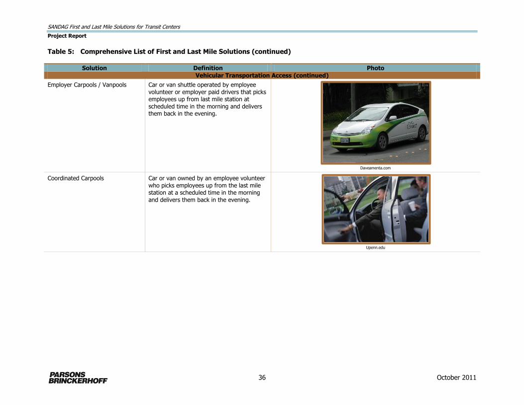
Employer Carpools / Vanpools Car or van shuttle operated by employee volunteer or employer paid drivers that picks employees up from last mile station at scheduled time in the morning and delivers them back in the evening.
Daveamenta.com
Coordinated Carpools Car or van owned by an employee volunteer who picks employees up from the last mile station at a scheduled time in the morning and delivers them back in the evening.
Upenn.edu

SANDAG First and Last Mile Solutions for Transit Centers
Project Report
37 October 2011
Amenities
Provide wider passenger waiting platforms along Clairemont Mesa Boulevard and Complex Drive
to increase passenger comfort and create more distance between street traffic and waiting
passengers.
Provide more-substantive, branded passenger shelters at the transit center.
Provide more passenger seating at the transit center.
Provide real-time transit vehicle arrival information at the transit center.
Provide signage and wayfinding decision markers within ½ mile of the transit center and at
freeway approaches.
Create a station “trademark” identification sign and/or architectural features.
Personal Safety
Add pedestrian-scale lighting along the Complex Street and Complex Drive approaches to the
transit center.
Motorized Improvements
Encourage area employers to individually or jointly provide an employer shuttle between the
transit center and employment sites.
Develop a SANDAG/employer partnership to provide shuttles between the transit center and
employment sites.
Develop a program to create and encourage employer carpools/vanpools between the transit
center and employment sites.
Develop a program to create and encourage coordinated carpools (employee-owned vehicles)
between the transit center and employment sites.
32nd & Commercial Station Screened Improvements for Further Consideration
Pedestrian Access and Traffic Safety Improvements
Implement sidewalks or designated pedestrian paths along Commercial Street approaching the
station.
Upgrade the sidewalks and curb ramps within ¼-mile radius of station to meet ADA standards.
Repair sidewalks within ¼-mile radius of the station.
Auto Access Improvements
Add a designated passenger drop-off/pick-up zone (kiss-and-ride) at the station near the 32nd
Street entrance.
Negotiate an agreement with the church adjacent to the station for shared-use parking spaces.
Bicycle Access Improvements
Provide secure bicycle lockers at the station.
Implement a stairway bike channel along the stairs from the north side of the station to Imperial
Avenue.
Implement the bicycle lanes and paths identified in SANDAG’s 2050 Regional Bike Plan and the
City of San Diego’s Bicycle Master Plan within 1 mile of the transit center.

SANDAG First and Last Mile Solutions for Transit Centers
Project Report
38 October 2011
Amenities
Implement real-time schedule information at the station. (This is planned as part of the MTS
Orange Line rehabilitation project.)
Provide signage and wayfinding decision markers within ¼-mile of the station, particularly along
Imperial Avenue, Market Street, and Ocean Boulevard.
Add passenger shelters at the station.
Personal Safety
Add pedestrian scale lighting along 32nd Street and Commercial Street approaching the station.
Improve lighting along stairway and under LRT bridge over Imperial Avenue.
Remove southeastern fence or replace with transparent fencing.
Coordinate with adjacent property owners (church, businesses) to improve station area
environment (lighting, shrubbery trimming, sidewalk repair, etc.).
Motorized Improvements
Develop a SANDAG/employer partnership to provide shuttles between the transit center and
employment sites in the Gateway Center area.
5 Stakeholder Input
Stakeholder input was sought on the barriers to access at each station and the screened solutions
that might help overcome those barriers. The goals of the stakeholder input were to ascertain which
potential first and last mile solutions might have the most success in overcoming the barriers and
attracting transit riders.
As a result, it was especially important to survey transit riders who may be intimately familiar with
the barriers to access and non-users of transit to determine what access barriers might be preventing
them from taking transit. For the study purpose, a qualitative, non-statistically significant survey
approach was implemented and deemed sufficient to provide useful data.
Stakeholders included transit riders, residents, employees, employers, planning group members, and
community leaders. Kearny Mesa Transit Center area stakeholders would primarily be transit riders,
employees, and employers since the need at this station is primarily for a last mile solution (from the
transit center to work site). 32nd & Commercial Station area stakeholders would be primarily transit
riders, residents, and planning and community group members since the need at this station is
primarily for a first mile station (from home to station). Identified stakeholder groups for each station
is included in Appendix B.
5.1 Intercept and Web Surveys
Stakeholder input was obtained in three ways:
Intercept surveys at the stations
Web-based surveys administered through employers
Meetings with interested employers and individuals.

SANDAG First and Last Mile Solutions for Transit Centers
Project Report
39 October 2011
Intercept Surveys
Transit riders were the target stakeholders for the intercept surveys, which were conducted at each
station on one weekday from 6 a.m. until 6 p.m. (although most of the responses were obtained
during the peak periods). The SANDAG survey team administered the surveys, which questioned the
respondents about the following:
Mode of access to the station
Purpose of travel
Origin/destination
Usage frequency
Alternatives available
Station deficiencies and needs
Station access issues and barriers
Likelihood that they would use a variety of described access solutions (the screened solutions)
Any ideas or suggestions they might have regarding access to the station.
The intercept survey questionnaires are included in Appendix C1.
Web-based Surveys
The target stakeholders for the Web-based surveys were employees for the Kearny Mesa Transit
Center area and residents for the 32nd & Commercial Station area. SANDAG coordinated with
employers in the Kearny Mesa Transit Center area to provide information about the surveys to their
employees and encourage response. SANDAG asked community groups in the 32nd & Commercial
Station area to distribute information about the resident survey. The Web-based survey
questionnaires asked respondents about the following:
Use of the station
Purpose of travel
Origin/destination
Travel frequency
Travel alternatives
Station deficiencies and needs
Station access issues and barriers
Likelihood that they would use a variety of described access solutions
Any ideas or suggestions they might have regarding access to the station.
The intercept survey questionnaires are included in Appendix C2.
SANDAG had intended to conduct focus groups to delve further into barrier issues and promising
solutions but found it challenging to solicit interest in focus-group participation. In lieu of formal
focus groups, SANDAG met with interested individuals to get their perspectives and input on potential

SANDAG First and Last Mile Solutions for Transit Centers
Project Report
40 October 2011
access solutions. Several individuals were associated with the County of San Diego, which is one of
the largest employers in the Kearny Mesa Transit Center area with plans to move more county
employees to Kearny Mesa over the next few years.
5.2 Results and Conclusions
Although the number of survey responses was small, particularly for the web-based surveys, useful
information could be gleaned from them. Key survey results provided information on the following:
Station access deficiencies noted most often (poorest-rated station features)
Station features rated worst at meeting access needs (worst at meeting needs)
Station access features identified most often as those that would encourage respondents to use
transit (more likely to ride)
Station features noted most often as those that would make it easier to access the station
(makes it easier).
A summary of the above findings for each station are included in Tables 6 and 7.
Table 6: Kearny Mesa Transit Center Station Key Survey Findings
Transit Rider Intercept Web-based – Employees
Worst at Meeting Needs (Question 7A – 7H) Responses*
Likely to Ride if Added/Improves (Question 10) Responses**
Bike Racks 47% Transportation between station/work 83%
Lighting 27% Bike Share Program 83%
Security 26% Car Share Program 71%
What Makes It Easier?
(Question 6)
Bike Lanes between station/work 67%
More Sidewalks between station/work 67%
Shuttle 21% Employer Carpool Program 50%
Dedicated pick up/drop off 13% Better Lighting Along Route 50%
Fix sidewalks/better lighting 7% More sidewalks 6%
Table 7: 32nd & Commercial Station Key Survey Findings
Transit Rider Intercept
Web-based – Residents
Poorest Rated Features (Question 7A-7H)
# of Responses*
Likely to Ride if added/improved (Question 6)
# of Responses**
Bike lanes 34% Parking transit to station 100%
Signs to station 16% Pick up/drop off 88%
Safe routes to station 13% Bike lanes 75%
Worst at Meeting Needs (Question 9A-9J)
Lit sidewalk 72%
Bike Racks/lockers 72%
Bike racks/lockers 56% Disability access 57%
Security 36%
Parking 32%
Lighting 24%
*On a scale of 1-5 in which 1 = Very Poor and 5 = Very Well, the percentage of who responded 1 or 2 **Includes Very Likely, Likely, Somewhat Likely Responses

SANDAG First and Last Mile Solutions for Transit Centers
Project Report
41 October 2011
The survey results for the Kearny Mesa Transit Center indicate the following kinds of improvements
could go the farthest to improve access and encourage transit use:
Bicycle facilities, including storage, designated bike routes, and bike share programs
Motorized transportation between the transit center and work sites, including shuttles and
carsharing
A convenient, safe auto drop-off/pick-up location at the transit center
More and better sidewalks
Lighting and security.
The survey results for the 32nd & Commercial Station indicate the following kinds of improvements
could go the farthest to improvement access and encourage transit use:
Bicycle facilities, including storage and designated bike routes
Wayfinding signage to the station
Security, including lighting along routes to the station
Parking at the station
A convenient, safe auto drop-off/pick-up location at the transit center.
Meetings with interested individuals in the Kearny Mesa Transit Center area provided the following
personal insights:
Implementing motorized last mile solutions to major employment sites in the Kearny Mesa area
should be a priority.
Motorized solutions should focus on coordination with employers such as the sheriff’s department,
FBI, DEA, Solar Turbines, and Jack-in-the-Box.
The County of San Diego owns land at Ruffin Road and Kearny Mesa Boulevard that might be a
good site to relocate the transit center to provide an off-street facility.
SANDAG should expand promotion of the eco-pass program that provides discounts to employers
for bulk purchase of transit passes.
A ¼-mile walking distance from the transit center to work sites is acceptable but the sidewalks in
the area could be better.
It could be a challenge to generate interest in employer-provided carpools from the transit center
as the County of San Diego, and possibly other employers would not be able to assume the cost
of a carpool fleet.
Additional information garnered from meetings with interested individuals who are employed by the
County of San Diego revealed that the county is expanding its facilities on Overland Avenue north of
Clairemont Mesa Boulevard, which is one (long) block east of the Kearny Mesa Transit Center. The
new county campus will ultimately have approximately 900,000 square feet of new office space in six
4-story buildings and an 84,000-square-foot Medical Examiner and Forensic Center building.
Construction of the first two buildings was completed in October 2010, and two additional buildings
are scheduled for completion in spring 2012. The remaining build-out, subject to funding approval,
SANDAG First and Last Mile Solutions for Transit Centers
Project Report
42 October 2011
would be completed in 2014. The county plans to consolidate employees located throughout the
region, particularly those in downtown facilities. To address the transportation burden placed on
relocated employees who previously took transit to downtown locations, the county has implemented
a free weekday peak period employee shuttle service between downtown San Diego (from America
Plaza where employees can transfer from Trolley, COASTER and bus routes) and its Overland Avenue
campus. In addition, the County provides shuttle service throughout the day within Kearny Mesa to
transport county employees among county offices and facilities in the Kearny Mesa area. The shuttle
service is provided by a contractor and the peak period downtown to Kearny Mesa portion is funded
through the County Operations Center construction project. This existing all-day and peak-period
(albeit temporarily funded) shuttle service may provide opportunities for funding partnerships with
other Kearny Mesa area employers and/or SANDAG to expand service to the Kearny Mesa Transit
Center and multiple employers.
6 First and Last Mile Solutions Recommendations
Drawing from the comprehensive list of solutions, site visits, community input, and the study goals
and parameters, first and last mile solution recommendations for Kearny Mesa Transit Center and
32nd & Commercial Station were developed. These station access solution recommendations are
divided into two categories:
Physical (Capital) Solutions – physical improvements at and near the stations; and
Motorized Solutions – shuttle, carpool, or vanpool connections between the stations and origins/
destinations.
Based on station area characteristics, SANDAG identified physical solutions for both the Kearny Mesa
Transit Center and the 32nd & Commercial Station, but motorized solutions for Kearny Mesa Transit
Center only.
6.1 Kearny Mesa Transit Center Last Mile Solution Recommendations
Physical Solutions
Objective: Improve pedestrian access
Recommended Solutions:
Add new pedestrian connections to residential areas to the south of the station on Paramount
Drive and Spectrum Center Drive.
Widen sidewalks along Clairemont Mesa Boulevard east of the transit center and upgrade ADA
ramps between the transit center and county facilities on Overland Avenue.
Implement traffic-calming designs at the intersection of Clairemont Mesa Boulevard and Complex
Drive, and at the intersection of Clairemont Mesa Boulevard and Overland Avenue such as corner
bulb-outs, unique crosswalk paving, or other features, which would alert drivers that the
intersection exists for pedestrians as well as cars.
SANDAG First and Last Mile Solutions for Transit Centers
Project Report
43 October 2011
Conduct a walk-audit of the station area as part of the planned February 2012 visit to SANDAG
by Dan Burden, Executive Director of the Walkable and Livable Communities Institute to further
identify specific pedestrian access improvements in the Kearny Mesa Transit Center area.
Objective: Improve auto access
Recommended Solutions:
Create a formal kiss-and-ride and drop-off location at the station may require ROW acquisition.
Acquire, though purchase or agreement, parking spaces from adjacent property owners (i.e.,
Bank of America) for last mile carpools/vanpools and commercial carsharing programs.
Objective: Improve bicycle access
Recommended Solutions:
Close gaps in the bicycle network in the station area, including on Balboa Avenue, Spectrum
Center Boulevard, and Mercury Street.
Sign Class III bicycle routes on Clairemont Mesa Boulevard.
Implement the bicycle lanes and routes identified in SANDAG’s 2050 Regional Bike Plan and the
City of San Diego’s Bicycle Master Plan that lead to and through the Kearny Mesa area.
Add bicycle lockers at the station, possibly in the Bank of America parking lot.
Objective: Improve station amenities
Recommended Solutions:
Provide wider passenger waiting platforms along Clairemont Mesa Boulevard and Complex Drive
to increase passenger comfort and create more distance between street traffic and waiting
passengers.
Provide more-substantive, branded passenger shelters at the transit center.
Provide more passenger seating at the transit center.
Provide real-time transit vehicle arrival information at the transit center.
Provide signage and wayfinding decision markers within ½ mile of the transit center and at
freeway approaches.
Create a station identification sign and/or architectural features to help brand the station and
make it recognizable as a key transit hub.
Objective: Improve personal safety
Recommended Solutions:
Add pedestrian-scale lighting approaching station, including on Clairemont Mesa Boulevard,
Complex Drive, Complex Street, and Overland Avenue.

SANDAG First and Last Mile Solutions for Transit Centers
Project Report
44 October 2011
Physical Solutions Implementation
To implement the physical improvements in the Kearny Mesa Transit Center area, SANDAG should:
Incorporate the associated capital investments into the 2013 I-15 BRT service and infrastructure
project budget and development. The planned I-15 BRT provides an opportunity to make
investments in the Kearny Mesa Transit Center to bring it up to BRT facility standards, including
passenger amenities and branding.
Incorporate the physical solutions into appropriate regional plans and capital improvement
programs, including the SANDAG Regional Transportation Plan, Regional Comprehensive Plan,
Transportation Improvement Program, I-15 BRT Project, and SANDAG Bicycle Master Plan.
Work with the City of San Diego to incorporate the recommended physical solutions into local
community plans and capital improvement programs.
Motorized Solutions
Objective: Improve motorized access
Recommended Solutions:
Pursue programs and activities to encourage implementation of employer-sponsored shuttles
between the transit center and work sites that would be owned and operated by private
employers, either individually or through a consortium.
Implement programs and activities to secure partnerships for SANDAG/employer-sponsored
carpools in which:
Automobiles (or vans) may be owned by employers for use by employee carpools.
SANDAG and employers would partner to implement a program to identify drivers,
carpool groups, and schedules.
The carpools would take employees from the transit station to the employment site in
the mornings and back in the evenings.
Carpool vehicles would be parked at the employment sites during the day (and could
double as company fleet vehicles during the day) and in designated parking spaces at
the transit station overnight.
Pursue programs and activities to encourage coordinated carpools in which:
Employees use their personal, privately owned vehicles for carpools from the transit
station.
SANDAG and employers would partner to implement a program to connect willing
employee drivers with transit-riding co-workers and coordinate pick-up and delivery
schedules.
Drivers would stop at the transit center on their way to work in the mornings to pick up
designated passengers before continuing to their work sites and make the reverse trip on
their way home in the evenings.
SANDAG and/or employers might offer incentives to drivers to conduct the carpools.
SANDAG First and Last Mile Solutions for Transit Centers
Project Report
45 October 2011
To support implementation of the motorized solutions in the Kearny Mesa Transit Center area, a
Strategy and Guide for Engaging Employers in Last Mile Transportation Solutions has been prepared
as part of this study to provide SANDAG with a framework to identify, promote, and implement
innovative partnerships for providing shuttle, carpool, and vanpool access between the station and
major employment sites. SANDAG should actively pursue the identified strategies and steps to enter
into partnerships with employers to implement motorized programs that address the last mile gap
from the transit center to employment sites in the area. This guide constitutes the Pilot Project
Implementation Plan for the First Mile and Last Mile Solutions for Transit Centers study.
Motorized Solutions Implementation
Implementing and funding motorized solutions can involve the public or private sectors, or more
likely, a combination of both. Possible implementation and funding approaches for motorized
solutions that SANDAG should consider include:
Last mile pilot projects in the Kearny Mesa area may be competitive for federal Jobs Access
Reverse Commute grant funding, which is awarded to transportation programs and services that
promote access to jobs from lower-income communities. Implementation of the new all day I-15
BRT service in 2013 will provide a fast and direct transit connection between Mid-City San Diego
and the Kearny Mesa Transit Center. Travel demand analyses conducted for the SANDAG Urban
Area Transit Strategy in 2009 identified a strong demand from the largely residential communities
in central San Diego (including Mid-City) to employment centers to the north, primarily Kearny
Mesa and Sorrento Mesa. The Mid-City area has a higher percentage of low-income households
than the region as a whole. A motorized last mile solution from the Kearny Mesa Transit Center
would provide the final access piece for workers in Mid-City San Diego who will be able to take
the new BRT to Kearny Mesa.
The County of San Diego has implemented an employee shuttle from downtown San Diego to its
Kearny Mesa site to provide a connection to regional transit services in downtown. SANDAG
should seek opportunities with the county to have the shuttle serve the Kearny Mesa Transit
Center, particularly as more county employees relocate to the expanding Kearny Mesa County
facilities.
The Industrial Environmental Association, a trade organization of industrial companies, includes
many large employers in the Kearny Mesa area. This association actively monitors and
participates in a number of issues and activities that affect its members, including land use
planning, transit and transportation, and regulatory issues. Similar regional organizations such as
the San Diego Economic Development Corporation, the San Diego Regional Chamber of
Commerce and other industry specific associations may provide opportunities for SANDAG to
connect with employers in the Kearny Mesa area, highlight the last mile gap issue, and seek
implementation and funding partnerships through a larger group or employers.

SANDAG First and Last Mile Solutions for Transit Centers
Project Report
46 October 2011
6.2 32nd & Commercial Station First Mile Solution Recommendations
Physical Solutions
Objective: Enhance pedestrian access
Recommended Solutions:
Implement sidewalks or designated pedestrian paths along Commercial Street approaching the
station.
Upgrade the sidewalks and curb ramps within ¼-mile radius of station to meet ADA standards.
Repair sidewalks within ¼-mile radius of the station.
Objective: Improve automobile access
Recommended Solutions:
Design and construct a formal pick-up/drop-off (kiss-and-ride) location at the station.
Pursue a parking agreement with the adjacent Christ the King Catholic Church for shared-use
transit park-and-ride spaces.
Objective: Improve bicycle access
Recommended Solutions:
Designate bicycle routes to station on Commercial Street and 30th Street.
Sign bicycle routes.
Add bicycle channel on stairs between station and Imperial Avenue.
Add bicycle storage lockers at the station.
Objective: Improve station amenities
Recommended Solutions:
Implement station upgrades to enhance station environment, including new platform, paving on
tracks, shelters, and real-time signs.
Add wayfinding signage to station from Imperial Avenue, 32nd Street, and Commercial Street.
Objective: Improve personal safety
Recommended Solutions:
Improve lighting along stairway and under LRT bridge over Imperial Avenue.
Enhance streetlights approaching station on Commercial Street, Imperial Street, Webster Street,
and 32nd Street.
To improve visibility and sense of security, eliminate or trim hedge on north side of station
adjacent to the Christ the King Catholic Church.

SANDAG First and Last Mile Solutions for Transit Centers
Project Report
47 October 2011
Seek community partners, including the Christ the King Catholic Church, to create a
neighborhood watch program.
Work with property owner to improve visibility and safety for pedestrians by removing slats from
chain-link fence on Commercial Street south of the station.
Physical Solutions Implementation
To implement the physical improvements in the 32nd & Commercial Station area, SANDAG should:
Incorporate the physical solutions into appropriate regional plans and capital improvement
programs including the SANDAG Regional Transportation Plan, Regional Comprehensive Plan,
Transportation Improvement Program, Orange Line rehabilitation project, and SANDAG Bicycle
Master Plan.
Work with the City of San Diego to incorporate the recommended physical solutions into local
community plans and capital improvement programs.
7 First Mile and Last Mile Strategy and Implementation
Guide
7.1 Purpose of this Guide
Closing the gap between the first or last mile of an employee's transit trip is an important part of
making transit a viable alternative to driving. This section constitutes a guide that presents potential
solutions, partnership options and implementation steps for SANDAG to undertake to engage and
secure employers as partners in creating and implementing end-of-trip solutions to connect workers
from nearby transit stops to their places of work. The guide was prepared specifically to focus on
solutions and public-private partnerships that would help close the first mile/last mile gap between
the Kearny Mesa Transit Center and surrounding major employers. Building upon the new I-15 Bus
Rapid Transit (BRT) route scheduled to begin serving the Kearny Mesa Transit Center in 2013,
employer sponsored connections between the Kearny Mesa Transit Center and employment sites
affords an important opportunity to improve transit use and connectivity in this area.
7.2 Program Background
In 2010/2011, SANDAG conducted a study to identify a pilot project that would demonstrate a first or
last mile solution to a transit station (The First and Last Mile Solutions for Transit Stations study). The
identified pilot project(s) would close the “first mile/last mile” gap in transit service – the first mile
between home and the transit station or the last mile between the transit station the destination.
Access to and from the transit station is often the largest impediment to transit use for many
potential transit riders. SANDAG selected two stations for this study, the 32nd Street Trolley Station
and the Kearny Mesa Transit Center. Because the study focused on commute trips, these stations
were selected for their proximity to residential first mile trips (32nd Street) and employment related
last mile trips (Kearny Mesa).

SANDAG First and Last Mile Solutions for Transit Centers
Project Report
48 October 2011
To gauge public opinion about potential first and last mile solutions, SANDAG sought input from
community groups, residents, employers, employees and transit riders around each station. Outreach
efforts consisted of station intercept and web-based surveys, as well as interviews and meetings with
select individuals. Based on public input received and technical study, SANDAG identified a number of
physical improvements to enhance access to the two stations.
For the Kearny Mesa Transit Center, the overwhelming opinion from both transit riders and
employees who don’t currently ride transit is that a shuttle service or similar kind of motorized access
would be the most helpful improvement to bridge the last mile gap between the transit station and
their places of employment. For this reason, SANDAG selected the Kearny Mesa Transit Center as the
focus of an approach for implementing motorized solution pilot project(s).
7.3 Program Objectives
SANDAG established several key objectives for the first and last mile pilot project:
It should focus on commute (work) trips.
It should focus on programmatic solutions.
It should identify easy to implement capital improvements.
It should seek private sector partnerships to share costs.
It should be consistent with existing land uses.
It should reflect stakeholder input and needs.
Because project resources are limited and implementing a publicly operated and subsidized shuttle or
motorized transportation program does not meet project objectives to require little or no ongoing
public operating subsidy, this Strategy and Guide for Engaging Employers in Transit Solutions has
been prepared to pursue public-private partnerships for implementation of a shuttle or motorized
transportation pilot project. The purpose of this strategy is provide a framework for employer support
for a pilot project and guidance to SANDAG to work with employers in the Kearny Mesa area to
develop a potential public-private transportation solution for closing the last mile gap between the
Kearny Mesa Transit Center and places of employment, thus encouraging more employees to take
transit.
7.4 Opportunities and Benefits
Providing gap closure transit improvements to and from the Kearny Mesa Transit Center presents a
number of opportunities and benefits for SANDAG, employers in the area, and employees.
The I-15 BRT line will begin service in 2013 and will stop at the Kearny Mesa Transit Center. This
new service will operate between Escondido and downtown San Diego via Mid-City all day in both
directions, every 15 minutes during peak periods and every 30 minutes in the midday and
evenings (see Figure 9). It will travel on the I-15 Managed Lanes (express lanes) serving six
transit centers along the route, including the Kearny Mesa Transit Center, connecting employee
residential areas with the Kearny Mesa job center. Because BRT service will be significantly faster
than local bus service, transit will become a more viable transportation choice for a larger
number of commuters.
SANDAG First and Last Mile Solutions for Transit Centers
Project Report
49 October 2011
Construction on the new County Operations Center in Kearny Mesa is underway and will be
complete in 2014. The County is currently operating a shuttle for employees between downtown
San Diego and Kearny Mesa. With the participation of SANDAG and other Kearny Mesa employers,
there may be opportunities to partner with the County and expand shuttle service to include the
Kearny Mesa Transit Center and other major employers in the area.
Having an operational motorized last mile connection in place from the Kearny Mesa Transit
Center will encourage greater transit ridership and help support regional mobility and
sustainability programs and goals.
Implementation of a viable last mile solution at the Kearny Mesa Transit Center will allow
employers to promote transit use and offer incentives for their employees to take transit.
Convenient transit options will expand the pool of potential employees for Kearny Mesa area
employers to include those who don’t have a car available for their commute trip, reduce
commuting stress for employees so that they arrive to work in a positive and productive state of
mind, and provide opportunities for employers to be corporate leaders in promoting
environmental stewardship and sustainability through support for alternative travel modes by
their employees.
7.5 Strategic Framework for Engaging Employers
For a shuttle service or other kinds of motorized last mile solutions (i.e., carpools) to be successful,
SANDAG will need the active participation of key employers in the Kearny Mesa area through a
public-private partnership. Not only will key employers be needed to buy-in to the concept and agree
to participate, but these employers will also need to take a leadership role in attracting additional
employers to the table to support and help fund the solutions. Following are six strategic activities
that SANDAG should undertake to successfully engage the Kearny Mesa area employers in
discussions, generate an understanding of the need for a last mile solution, and garner support from
employers to become an active partner in implementing last mile solutions in coordination with
SANDAG:
Complete Research and Preparation
Before initiating contact with employers, SANDAG staff should:
Identify key employers and a contact person for each employer – Large, medium-size,
and high-profile employers should be the target of initial contact as they have the greatest
potential to benefit from a last mile solution and are more likely have the resources to support a
last mile solution. The initial outreach process will be facilitated by having a specific person to
contact for each employer versus making cold calls. Table 8 provides an initial list of key Kearny
Mesa area employers and trade associations as of July 2011. The names, positions, and contact
information for individuals at each employer is on file at SANDAG.

SANDAG First and Last Mile Solutions for Transit Centers
Project Report
50 October 2011
Figure 9: Planned I-15 BRT Service to Kearny Mesa Transit Center
SANDAG First and Last Mile Solutions for Transit Centers
Project Report
51 October 2011
Develop an initial contact presentation and marketing script – The I-15 BRT scheduled to
begin service to the Kearny Mesa Transit Center in 2013 can be promoted to employers as a
benefit that expands their ability to attract employees, and can be identified as a catalyst for
implementing a last mile solution. SANDAG should craft the message, prepare a presentation
outline and/or script (both for the initial phone or email contact and the first face-to-face
meeting), and develop leave behind materials that market the new BRT, explain the last mile
goals, benefits, and partnership objectives, and provide a description of potential last mile
solutions. Motorized solution descriptions and examples are provided in the October 2011 First
and Last Mile Solutions for Transit Centers report and in this Strategy and Guide.
Assess the level of support SANDAG may be willing to provide for each potential
solution – The partnership concept for a last mile solution requires that SANDAG participate at
some defined level. SANDAG staff will need to have an idea of how SANDAG would or could
participate and provide support, and what might be expected of employers. SANDAG support can
be in-kind staff support to define the details of the solution, provide administrative start-up
assistance, maintain an employee outreach and marketing program, administer a Transportation
Management Association or other employer consortium, and/or provide ongoing program and/or
service management and monitoring. SANDAG can also provide one-time capital funding for
vehicles, signage, or other facilities, and/or ongoing operating funding to support operating costs,
marketing and administrative expenses, vehicle leases, or insurance.
Identify a Political Champion
To help SANDAG make inroads with employers and get commitments to participate in developing a
last mile solution, an elected official champion and prominent business leaders should be recruited to
work with SANDAG staff and employers. The champion should be from the SANDAG Board or
Transportation Committee, and preferably someone who can help identify and persuade prominent
business leaders from the Kearny Mesa area to step forward in support of the last mile solution
partnership program. The champion would be asked to head an Employers Transit Task Force and
along with the identified business leaders could speak publicly about the project and convey its
benefits to the business community and general public.
Conduct One-on-One Meetings with Key Employers
SANDAG should conduct one-on-one meetings with the key employers to present the program goals,
benefits, potential last mile solutions, and partnership proposals. These initial meetings should be
high level and conducted with the elected official champion and the CEO of the identified employers,
with support from SANDAG staff. The intent of these meetings is to gain buy-in on the idea that
increased transit access is beneficial to both employers in the area and their employees, and obtain
an initial commitment from employers that they will participate in next steps toward developing a
public-private partnership motorized solution to bridge the last mile between the Kearny Mesa Transit
Center and their employment site.
Depending on the employer, next steps may be participating in an employers’ task force as described
below or continuing to work with SANDAG toward an individual solution. SANDAG may need to follow
two potential paths simultaneously, as shown in Figure 10.
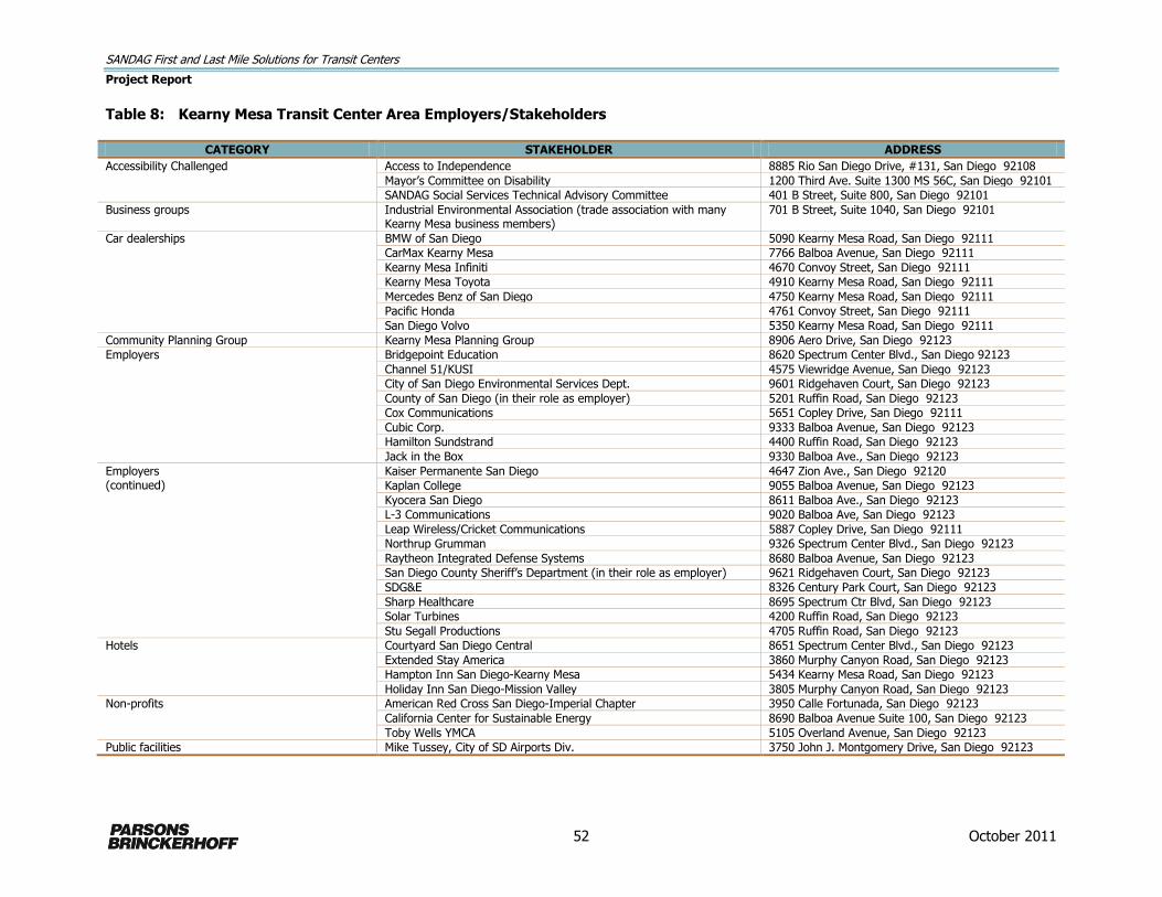
SANDAG First and Last Mile Solutions for Transit Centers
Project Report
52 October 2011
Table 8: Kearny Mesa Transit Center Area Employers/Stakeholders
CATEGORY STAKEHOLDER ADDRESS
Accessibility Challenged Access to Independence 8885 Rio San Diego Drive, #131, San Diego 92108
Mayor’s Committee on Disability 1200 Third Ave. Suite 1300 MS 56C, San Diego 92101
SANDAG Social Services Technical Advisory Committee 401 B Street, Suite 800, San Diego 92101
Business groups Industrial Environmental Association (trade association with many Kearny Mesa business members)
701 B Street, Suite 1040, San Diego 92101
Car dealerships BMW of San Diego 5090 Kearny Mesa Road, San Diego 92111
CarMax Kearny Mesa 7766 Balboa Avenue, San Diego 92111
Kearny Mesa Infiniti 4670 Convoy Street, San Diego 92111
Kearny Mesa Toyota 4910 Kearny Mesa Road, San Diego 92111
Mercedes Benz of San Diego 4750 Kearny Mesa Road, San Diego 92111
Pacific Honda 4761 Convoy Street, San Diego 92111
San Diego Volvo 5350 Kearny Mesa Road, San Diego 92111
Community Planning Group Kearny Mesa Planning Group 8906 Aero Drive, San Diego 92123
Employers Bridgepoint Education 8620 Spectrum Center Blvd., San Diego 92123
Channel 51/KUSI 4575 Viewridge Avenue, San Diego 92123
City of San Diego Environmental Services Dept. 9601 Ridgehaven Court, San Diego 92123
County of San Diego (in their role as employer) 5201 Ruffin Road, San Diego 92123
Cox Communications 5651 Copley Drive, San Diego 92111
Cubic Corp. 9333 Balboa Avenue, San Diego 92123
Hamilton Sundstrand 4400 Ruffin Road, San Diego 92123
Jack in the Box 9330 Balboa Ave., San Diego 92123
Employers (continued)
Kaiser Permanente San Diego 4647 Zion Ave., San Diego 92120
Kaplan College 9055 Balboa Avenue, San Diego 92123
Kyocera San Diego 8611 Balboa Ave., San Diego 92123
L-3 Communications 9020 Balboa Ave, San Diego 92123
Leap Wireless/Cricket Communications 5887 Copley Drive, San Diego 92111
Northrup Grumman 9326 Spectrum Center Blvd., San Diego 92123
Raytheon Integrated Defense Systems 8680 Balboa Avenue, San Diego 92123
San Diego County Sheriff’s Department (in their role as employer) 9621 Ridgehaven Court, San Diego 92123
SDG&E 8326 Century Park Court, San Diego 92123
Sharp Healthcare 8695 Spectrum Ctr Blvd, San Diego 92123
Solar Turbines 4200 Ruffin Road, San Diego 92123
Stu Segall Productions 4705 Ruffin Road, San Diego 92123
Hotels Courtyard San Diego Central 8651 Spectrum Center Blvd., San Diego 92123
Extended Stay America 3860 Murphy Canyon Road, San Diego 92123
Hampton Inn San Diego-Kearny Mesa 5434 Kearny Mesa Road, San Diego 92123
Holiday Inn San Diego-Mission Valley 3805 Murphy Canyon Road, San Diego 92123
Non-profits American Red Cross San Diego-Imperial Chapter 3950 Calle Fortunada, San Diego 92123
California Center for Sustainable Energy 8690 Balboa Avenue Suite 100, San Diego 92123
Toby Wells YMCA 5105 Overland Avenue, San Diego 92123
Public facilities Mike Tussey, City of SD Airports Div. 3750 John J. Montgomery Drive, San Diego 92123
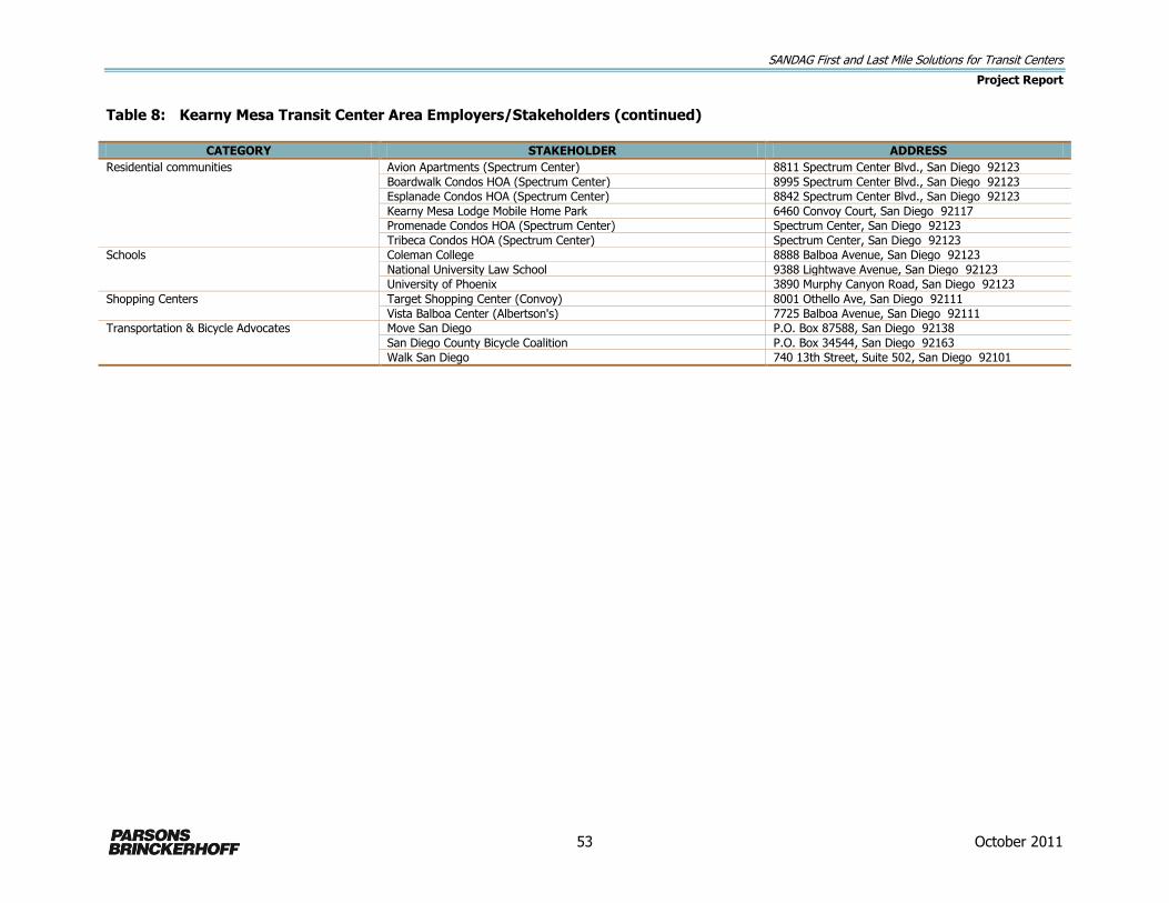
SANDAG First and Last Mile Solutions for Transit Centers
Project Report
53 October 2011
Table 8: Kearny Mesa Transit Center Area Employers/Stakeholders (continued)
CATEGORY STAKEHOLDER ADDRESS
Residential communities Avion Apartments (Spectrum Center) 8811 Spectrum Center Blvd., San Diego 92123
Boardwalk Condos HOA (Spectrum Center) 8995 Spectrum Center Blvd., San Diego 92123
Esplanade Condos HOA (Spectrum Center) 8842 Spectrum Center Blvd., San Diego 92123
Kearny Mesa Lodge Mobile Home Park 6460 Convoy Court, San Diego 92117
Promenade Condos HOA (Spectrum Center) Spectrum Center, San Diego 92123
Tribeca Condos HOA (Spectrum Center) Spectrum Center, San Diego 92123
Schools Coleman College 8888 Balboa Avenue, San Diego 92123
National University Law School 9388 Lightwave Avenue, San Diego 92123
University of Phoenix 3890 Murphy Canyon Road, San Diego 92123
Shopping Centers Target Shopping Center (Convoy) 8001 Othello Ave, San Diego 92111
Vista Balboa Center (Albertson's) 7725 Balboa Avenue, San Diego 92111
Transportation & Bicycle Advocates Move San Diego P.O. Box 87588, San Diego 92138
San Diego County Bicycle Coalition P.O. Box 34544, San Diego 92163
Walk San Diego 740 13th Street, Suite 502, San Diego 92101
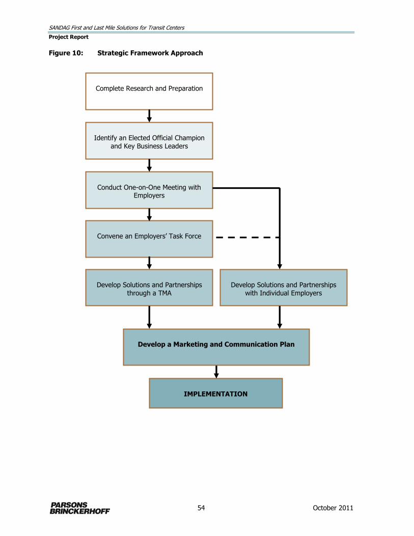
SANDAG First and Last Mile Solutions for Transit Centers
Project Report
54 October 2011
Figure 10: Strategic Framework Approach
Develop a Marketing and Communication Plan
Complete Research and Preparation
Identify an Elected Official Champion
and Key Business Leaders
Conduct One-on-One Meeting with Employers
Develop Solutions and Partnerships
with Individual Employers
Develop Solutions and Partnerships
through a TMA
Convene an Employers’ Task Force
IMPLEMENTATION

SANDAG First and Last Mile Solutions for Transit Centers
Project Report
55 October 2011
Convene an Employers Transit Task Force
Building off positive results from the one-on-one meetings with key employers and other contacts
and presentations made by the elected official champion, business leaders and SANDAG staff,
SANDAG should consider convening an Employers Transit Task Force to actively engage a broader
coalition of employers in the program goals and development of last mile solutions. This task could
work with SANDAG to identify viable solutions and possibly develop a multi-employer partnership
(such as a Transportation Management Association) to provide a coordinated last mile solution for
more than one employer. The task force should have a clear goal and timeline so that a plan can be
implemented in a reasonable period of time—preferably targeted to the initiation of the new I-15 BRT
service to the Kearny Mesa Transit Center in 2013.
Develop a Last Mile Motorized Solution Implementation Plan
Based on input from the Employers Transit Task Force and/or individual employers, and technical
information from SANDAG staff and consultants, develop an implementation plan and timeline for a
last mile motorized solution. The implementation plan should include the following:
1. Parameters
2. Procedures
3. Responsibilities of SANDAG and employer partners
4. Costs (capital, operation and maintenance)
5. Monitoring Program/Success factors
6. Marketing and Communications Strategy to promote the new service to employees
Items 1, 2, 3, and 4 are addressed in Section 7.6, Last Mile Solutions and Partnership Implementation
Options. Item 5 should be established through agreement between SANDAG and the employers. Item
6 is discussed below.
Develop a Marketing and Communications Plan
SANDAG should develop a plan to promote transit to the employees in the Kearny Mesa area. The
beginning of BRT service to the Kearny Mesa Transit Center in 2013 presents an opportunity to
significantly increase transit ridership among employees in the area. The purpose of a marketing and
communications strategy is to promote BRT service, paired with the selected last mile solution, to
employees as a viable alternative to commuting by car. The marketing and communications plan
should include a stakeholders’ analysis, key messages to communicate information about the new
service, measurable objectives, and a list of coordinated strategies and tactics to draw from to
promote the new service among employees. Strategies and tactics may include:
Developing materials to provide information to employees about the benefits of using transit to
get to work.
Hosting a “kick-off” event to launch the new service. This event should include fun activities for
employees such as contests to win annual transit passes, interactive booths to provide
information about transit and the new service, free promotional items, food and music.
Engaging in media relations to promote coverage of the launch of the new service in print,
broadcast and online media.
Providing materials to help employers promote the new service among their employees. These
materials may include brochures, schedules, content for company newsletters, and ideas for
incentives to encourage employees to take transit.

SANDAG First and Last Mile Solutions for Transit Centers
Project Report
56 October 2011
Making presentations to employee groups.
Coordinating annual events or contests to coincide with events such as Rideshare Week and
Earth Day.
Providing information related to employer and employee commuter tax benefits. As of September
2011, employers may give their employees up to $230/month to commute via transit, vanpool, or
carpool. The employer gets a tax deduction which results in savings over providing the same
value in gross income. Employers may also allow employees to use pre-tax income to pay for
transit, vanpooling or carpooling and employers save on payroll tax.4
Implementation
Implementing the strategic framework actions and tactics identified above will help establish a strong
foundation of commitment for identifying and implementing a motorized last mile solution in the
Kearny Mesa area. This commitment, combined with the introduction of the faster, more direct BRT
transit service in 2013 presents a unique opportunity to launch a complete transit solution that can
serve the transportation needs of many area employees. The next section discusses potential
implementation activities.
7.6 Last Mile Solutions and Partnership Implementation Options
To move the employer partnerships toward last mile solution implementation, SANDAG will need to
identify a menu of feasible alternatives for consideration, along with the potential roles and
responsibilities for implementation. This section provides a selection of motorized solution options
and identifies actions that would be necessary to implement these prospective motorized solutions,
along with a corresponding menu of potential SANDAG and employer roles and responsibilities that
can be drawn from to create implementation partnerships.
Shuttles
Shuttles provide regularly scheduled connections for transit users between transit stops and their
origins/destinations. They require initial capital costs and ongoing operational costs, but offer
consistent, reliable service. Furthermore, shuttles can be owned and operated by private employers,
either individually or through a consortium. The generally estimated annual cost associated with
operating a single bus shuttle operating 6 hours a day for 250 days a year is $125,000. There may be
grant monies available to employers or consortiums of employers to help defray some of the costs. In
particular, air quality management agencies will often step forward to provide funding.
Three potential shuttle routes connecting the Kearny Mesa Transit Center with employers in the area
were developed to provide initial concepts for a last mile shuttle solution. Each shuttle route concept
focuses on a different geographic area and different employers in Kearny Mesa (see Figure 11). Each
shuttle route concept is described below with information on route length, travel time, service
frequency, number of vehicles required, and estimated annual operating cost. SANDAG can use these
shuttle concepts as a starting point for discussions with employers and for developing details of more
specific shuttle solutions.
4 Commuter Tax Benefits. Section 132(f) of the Internal Revenue Code. (http://www.nctr.usf.edu/programs/clearinghouse/commutebenefits/)

SANDAG First and Last Mile Solutions for Transit Centers
Project Report
57 October 2011
Figure 11: Kearny Mesa Transit Center Shuttle Routes

SANDAG First and Last Mile Solutions for Transit Centers
Project Report
58 October 2011
Northern San Diego County Complex – Route 1
Route 1 provides shuttle service to the northern portion of the Kearny Mesa area in a one-way loop
and serves the new County of San Diego complex and smaller employers located on Kearny Villa
Road and Ruffin Road.
Route Length: 2.2 miles
Travel Time: 11 minutes (assumed 12 mph average speed)
Frequency: 15 minute headways
Vehicles Required: 1
Annual Service Hours: 1,500
Annual Estimated Operating Cost5: $120,000
Southern Balboa Avenue - Route 2
Route 2 provides shuttle service to the southern portion of the Kearny Mesa area in a one-way loop
and connects to more than a half dozen major employers on Kearny Villa, Balboa Avenue, and Ruffin
Road.
Route Length: 3.2 miles
Travel Time: 15 minutes (assumed 13 mph average speed)
Frequency: 15 minute headways
Vehicles Required: 1
Annual Service Hours: 1,500
Annual Estimated Operating Cost6: $120,000
Southeastern - Route 3
Route 3 provides shuttle service to the southeast portion of the Kearny Mesa area in a one-way loop
serving employers on Ridgehaven Court and Ruffin Court.
Route Length: 4.3 miles
Travel Time: 20 minutes (assumed 13 mph average speed)
Frequency: 10-15 minute headways
Vehicles Required: 2
Annual Service Hours: 3,000
Annual Estimated Operating Cost7: $240,000
5 Cost assumptions for the routes are based operation 6 hours per day (a three-hour morning and evening peak period), 250 days per year. Per hour cost is $80 based on similar sized shuttle for UCSF in San Francisco.
6 Ibid. 7 Ibid.

SANDAG First and Last Mile Solutions for Transit Centers
Project Report
59 October 2011
Route Considerations
Adequate bus service exists on Ruffin and Balboa for supplemental midday service.
Route 1 assumes access through the County of San Diego complex internal circulation roads.
Access restrictions may require special dispensation for access for this route.
Planned frequencies for the new I-15 BRT service to Kearny Mesa Transit Center are 15 minute in
both directions; therefore, 15 minute frequencies on shuttle routes will only provide a timed
transfer to the BRT in one direction.
Depending on the travel direction of the shuttles, some BRT passengers would need to cross
Clairemont Mesa Boulevard to reach the shuttle stop.
Partnerships and Implementation Roles: Single Employer Operated Shuttle
Operated by a single employer, an employer-operated shuttle, vanpool or carpool program would
provide transportation services in a particular area for one primary employer. SANDAG and employer
responsibilities may include:
SANDAG:
Manage program setup, including providing information/marketing materials for employers to
share with employees.
Provide information on prospective shuttle contractors, related requirements, performance
criteria, cost evaluation, and contracting support.
Support route and schedule development.
Design and construct a formal pick-up/drop-off location at the Kearny Mesa Transit Center.
Provide capital funding for vehicles, signage, and other capital needs.
Assist with seeking funding for vehicle lease payments.
Assist with ongoing monitoring of shuttle use and suggest modification proposals, if
necessary.
Employer:
Provide a staff manager for shuttle service and employee marketing.
Promote regional transit service available at the Kearny Mesa Transit Center and the last mile
shuttle service to employees.
Contract with shuttle operator for operations and maintenance / Provide own operating and
maintenance staff.
Ensure appropriate insurance and liability coverage for the service is provided.
Provide the shuttle vehicle(s) (own or lease).
Assume responsibility for all operating and maintenance costs.
Partnerships and Implementation Roles: Transportation Management Association (TMA)
TMAs are non-profit, member-controlled organizations that provide transportation services in a
particular area, such as a commercial district or industrial park. They are generally public-private
partnerships, consisting primarily of area businesses with local government support. Support from
SANDAG may include program setup, capital funding, and driver/passenger coordination assistance.
TMAs typically hire private transit companies to operate the service, who carry their own insurance.

SANDAG First and Last Mile Solutions for Transit Centers
Project Report
60 October 2011
SANDAG and employer responsibilities for establishing a TMA to provide and oversee shuttle service
may include:
SANDAG:
Manage program setup, including providing information/marketing materials for employers to
share with employees.
Provide information on prospective shuttle contractors, related requirements, performance
criteria, cost evaluation, and contracting support.
Support route and schedule development.
Design and construct a formal pick-up/drop-off location at the Kearny Mesa Transit Center.
Assist with identifying capital funding for vehicles, signage, and other capital needs.
Assist with identifying sources of funds to help cover operating and maintenance costs.
Assist with ongoing monitoring of shuttle use and suggest modification proposals, if
necessary.
Employers:
Provide a staff representative to sit on the board of the TMA or provide input on TMA
activities.
Promote regional transit service available at the Kearny Mesa Transit Center and the last mile
shuttle service to employees.
Contract with shuttle operator for operations and maintenance.
Ensure appropriate insurance and liability coverage for the service is provided.
Provide the shuttle vehicle(s).
Contribute funds to the TMA for operating and maintenance costs.
Transportation Management Association Examples
Emery-Go-Round - The Emery-Go-Round TMA in Emeryville and Oakland runs a free shuttle service
connecting the MacArthur BART Station with residences, businesses and shopping in Emeryville. It is
funded by commercial property owners within the citywide transportation business improvement
district and is run by the TMA's board of directors. The Emery-Go-Round provides three routes—
Hollis, Shellmound/Powell, and Watergate Express—each with different weekend, weekday and
evening service described below. The fleet includes 14 shuttle vehicles and one van and has an
annual ridership of 1.3 million. The annual operating budget for this extensive shuttle program is
approximately $2.4 million (http://www.emerygoround.com/about-us).
Emery-Go-Round Shuttle Service
Hollis Shellmound/Powell Watergate Express
Frequency 10 min (peak) 20 min (midday)
15 min 15 min
Hours of Operation
Weekday: 5:45 a.m. – 10:15 p.m.
Weekday: 5:47 a.m. – 10:30 p.m. Saturday: 9:20 a.m. – 10:36 p.m. Sunday: 10:00 a.m. – 7:20 p.m.
Weekday AM: 7:10 – 10:03 a.m. Weekday PM: 3:15 – 7:06 p.m.
Route Distance 6.5 miles 7.2 miles 5.8 miles

SANDAG First and Last Mile Solutions for Transit Centers
Project Report
61 October 2011
Bishop Ranch Business Park - Bishop Ranch Business Park in San Ramon California has a TMA with
several transportation demand management programs, including a shuttle connecting Bishop Ranch
to BART. Using a fleet of 10 vehicles, the TMA operates five shuttles connecting to Dublin/Pleasanton
BART Station, Walnut Creek BART Station, San Ramon Transit Center, Pleasanton ACE, and Mitchell
Park and Ride Lot. The characteristics of each route are described below.
Incentive programs to encourage employees to take BART to one of these stations and complete
their trip to Bishop Ranch Business Park by shuttle include the following:
Guaranteed Ride Home Incentive – Provides a free ride home via taxi or rental car up to six times
each year if you carpool, vanpool, bike, walk or ride transit to work.
ACE Train Incentives – Provides one month of free rides on the ACE train to qualified new riders
who work in San Ramon and 50 percent off the second monthly pass for new riders.
Vanpool Incentive – Receive a 50 percent rebate on your vanpool fare for the first six months
(for new passengers).
Vanpool Driver/Coordinator Incentive – New drivers or coordinators who form a new vanpool
receive a $1,000 check after one year of operation.
TriDelta Express Incentive – Provides buy one month, get the second one free on the TriDelta
Express Bus service.
Free County Connection Bus Pass – Provides a free bus pass for all express and local County
Connection bus routes.
Bishop Ranch Business Park Shuttle Service
96
X:
Wa
lnu
t C
ree
k
BA
RT
Sta
tio
n
97
X:
Du
bli
n/
Ple
asa
nto
n B
AR
T
Sta
tio
n
95
X:
Sa
n R
am
on
Tra
nsit
Ce
nte
r to
Wa
lnu
t C
ree
k
BA
RT
92
X A
CE
Ex
pre
ss:
Ple
asa
nto
n A
CE
Tra
in S
tati
on
92
X M
itch
ell
Pa
rk
an
d R
ide
Frequency 10 to 20 min 30 min 40 min 60 min 60 min
Hours of Operation
Weekday AM: 5:35– 7:15 a.m. Weekday PM: 12:30 – 7:50 p.m.
Weekday AM: 6:30 – 9:30 a.m. Weekday PM: 3:55 – 7:00 p.m.
Weekday AM: 6:30 – 9:04 a.m. Weekday PM: 4:00 – 7:15 p.m.
Weekday AM: 5:35 – 8:24 a.m. Weekday PM: 3:40 – 7:45 p.m.
Weekday AM: 5:45 – 7:15 a.m. Weekday PM: 4:35 – 7:20 p.m.
Route Distance
24 miles (round trip)
20 miles (round trip)
24 miles (round trip)
12 miles (one way)
18 miles (one way)
Oyster Point Commuter Shuttle – The San Francisco-Oyster Point Commuter Shuttle operates Monday
through Friday during commute hours between the South San Francisco BART Station and the Oyster
Point Business Park. This shuttle is operated by the Peninsula Congestion Relief Alliance, which is San
Mateo County’s Transportation Demand Management Agency whose mission is to reduce the number
of single-occupancy vehicles in the county. The shuttle is 75 percent funded by operating grants from
the Bay Area Air Quality Management District, local Metropolitan Planning Organization (City/County
Association of Governments), and the San Mateo County Transit District. The remaining 25 percent of

SANDAG First and Last Mile Solutions for Transit Centers
Project Report
62 October 2011
funding is provided by nine participating employers in the Oyster Point Business Park. Each employer
pays its portion based on the number of employees. The fleet includes 2 shuttles and has an annual
ridership of more than 28,000.
Oyster Point Commuter Shuttle Service
Frequency Coincides with BART schedule, leave/arrive at BART station about every 30 minutes
Hours of Operation Weekday: 6:40 a.m. to 10:02 a.m. and 3:47 p.m. to 6:36 p.m.
Route Distance 5.5 miles (one way)
Carpools
Automobiles (or vans) owned by employers may be used for carpools to transport transit users
between transit stops and their destinations. SANDAG and employers may partner to implement a
program to connect drivers and riders with similar destinations and schedules.
The carpool would take employees from the transit station to the employment site in the mornings
and back in the evenings. Cars may be parked at the employment site during the day and at a
designated parking spot at the transit station overnight.
Partnerships and Implementation Roles
SANDAG and employer responsibilities for establishing a carpool program to provide and oversee
shuttle service may include:
SANDAG:
Manage program setup, including providing information/marketing materials for employers to
share with employees.
Provide ongoing staff support to establish and maintain a ride-matching database for
employers.
Provide information on appropriate vehicles and driver responsibilities.
Coordinate with local jurisdictions and or private property owners to identify overnight
parking for the vehicles adjacent to transit station.
Assist with identifying capital funding for vehicles, signage, and other capital needs.
Assist with ongoing monitoring of carpooling and vanpooling activities and suggest program
modifications, as appropriate.
Employers:
Provide a staff representative to coordinate carpooling activities and distribute information to
employees.
Purchase, maintain, and insure automobiles for carpooling.
Provide priority daytime parking for carpool vehicles at employment site.
Coordinated Carpools
Another option for carpooling involves privately owned vehicles used for carpooling from the transit
station to businesses in the area. SANDAG and employers would partner to implement a program to
connect willing employee drivers with transit-riding co-workers and coordinate pick-up and delivery
schedules. Drivers would stop at the transit center on their way to work in the mornings to pick up

SANDAG First and Last Mile Solutions for Transit Centers
Project Report
63 October 2011
designated passengers to continue to the work site, and make the reverse trip on their way home in
the evenings. To encourage drivers to participate, SANDAG and employers may need to offer
incentives to conduct the carpool.
Partnerships and Implementation Roles
SANDAG and employer responsibilities for establishing a carpool program to provide and oversee
shuttle service may include the following.
SANDAG:
Manage program setup, including providing information/marketing materials for employers to
share with employees.
Provide ongoing staff support to establish and maintain a ride-matching database for
employers.
Provide information on appropriate vehicles and driver responsibilities.
Assist with ongoing monitoring of carpooling and vanpooling activities and suggest program
modifications, as appropriate.
Employers:
Provide a staff representative to coordinate carpooling activities and distribute information to
employees.
Provide incentives to employees who carpool.
Provide priority daytime parking for carpool vehicles at employment site.
Next Step
There are several last mile solutions to pursue with employer partners and multiple permutations of
partnership roles and responsibilities that could be created to implement these solutions in the
Kearny Mesa area. The next step would be for SANDAG to undertake the steps identified in Figure 10
to engage Kearny Mesa area employers in pursuing and implementing the solutions.


SANDAG First and Last Mile Solutions for Transit Centers
Project Report – Appendices
October 2011
Appendix A
Narrowed Set of Stations Evaluation


SANDAG First and Last Mile Solutions for Transit Centers
Project Report – Appendix A: Narrowed Set of Stations Evaluation
A-1 October 2011
Population
Density
Population
Demographics
Population
Demographics
Employment
Density
Major
Employers
(50+)
Major
Employers
(50+)
Motorized
Access
Options
Bike Access6 Transit
Ridership
Population/Acre
within 2 miles of
station
Employed
Population
(employees/acre)
within 2 miles of
station4
Percent of
Household Auto
Ownership within 2
miles of station*
Employees/
Acre
within 2
miles of station
within 1
mile of station
within 3 miles
of station
feeder bus
(F),
park & ride
(P), and
None (N)
# intersections
(including
alleys)
within 1/2 mile
of station
linear mileage
(total) of bike
routes
(classes I, II,
III, IV) within
2 mile of
station
# of transit
riders in both
the AM and
PM peaks
combined
Coast Hwy Station 27001 12.9 94% 88% 3 5.1 15 124 1 P 191 11.7 87 5 9 15 2
Sprinter Crouch St Station 27002 10.1 94% 89% 3 4.3 20 130 0 P 63 26.6 186 5 8 22 4
El Camino Real Station Parking Lot 27003 7.1 95% 94% 2 3.9 6 168 1 P 43 32.7 147 5 8 22 4
Rancho Del Oro Station 27004 8.3 95% 95% 2 4.4 5 149 0 P 29 33.2 89 5 7 35 11
College Blvd Station 27005 9.7 95% 95% 2 4.1 26 155 1 P 61 31.8 194 4 7 35 11
Melrose Station 27006 13.4 94% 93% 3 3.8 19 123 0 P 53 22.4 122 5 8 22 4
Escondido Ave Station 27008 14.1 94% 94% 3 3.7 17 126 0 P 79 16.7 154 5 8 22 4
Buena Creek Station 27009 7.5 94% 96% 1 2.6 19 183 1 P 73 11.8 126 6 8 22 4
Palomar College Station 27010 7.6 94% 93% 2 5.6 43 197 2 FP 29 31.5 377 4 8 22 4
San Marcos Civic Center Station 27011 7.0 94% 95% 2 5.5 41 147 1 N 79 36.5 165 5 8 22 4
Cal State San Marcos Station 27012 6.4 94% 94% 2 5.1 36 170 2 N 64 32.8 67 5 9 15 2
Nordahl Rd Station 27013 6.5 94% 91% 2 5.9 49 205 2 P 47 21.1 68 6 10 11 1
Carlsbad Village Station 28001 10.1 96% 92% 4 4.2 21 129 0 FP 117 14.7 321 4 8 22 1
Carlsbad Poinsettia Station 28002 4.9 97% 96% 2 4.7 13 144 0 FP 49 21.9 315 5 7 35 2
Encinitas Station 28003 8.5 97% 95% 3 4.6 35 98 0 FP 121 14.7 336 4 7 35 2
Solana Beach Station 28004 4.7 97% 96% 2 3.5 22 72 0 FP 66 12.3 124 5 7 35 2
Beyer Blvd Station 75003 14.0 91% 87% 3 3.0 14 74 0 FP 94 13.1 617 4 7 35 4
Palm Avenue Station 75006 13.8 92% 89% 3 3.4 24 138 0 FP 57 13.2 1087 3 6 44 6
Palomar Street Station 75008 12.1 93% 88% 3 4.4 32 167 1 FP 73 12.1 1972 3 7 35 4
H Street Station 75010 10.1 92% 85% 4 5.3 35 195 2 FP 96 8.4 1299 3 9 15 2
Bayfront/E Street Station 75012 10.8 92% 84% 4 5.8 34 189 2 FP 107 8.7 1074 2 8 22 3
24th Street Station 75014 15.9 93% 81% 4 8.5 53 210 3 FP 130 6.1 988 3 10 11 1
Santee Town Center Station 75020 8.0 96% 96% 2 4.7 34 145 0 FP 38 21.4 402 5 7 35 14
Gillespie Field Station7
75022 7.3 96% 94% 1 6.1 40 195 2 P 22 21.5 309 6 9 15 11
Arnele Avenue Station7
75024 15.5 93% 89% 3 7.0 68 226 3 FP 48 17.3 408 5 11 9 7
Amaya Drive Station7
75029 11.4 96% 92% 4 5.2 31 223 2 FP 60 20.5 482 4 10 11 9
Grossmont Transit Center7
75030 11.0 96% 92% 4 4.6 44 189 1 FP 49 21.3 1098 3 8 22 12
70th St Station 75032 15.9 92% 92% 3 5.7 31 233 2 FP 143 16.6 187 3 8 22 12
Morena/Linda Vista Station 75044 9.2 95% 93% 2 9.1 59 366 4 FP 81 24.2 284 4 10 11 9
Hazard Center Station 75048 20.1 95% 88% 4 13.2 122 441 6 N 34 26.8 305 7 17 1 1
Mission Valley Center Station 75050 21.3 95% 87% 4 13.4 122 427 6 F 23 24.5 437 6 16 3 3
Rio Vista Station 75053 21.2 95% 87% 4 12.5 117 440 6 N 20 24.4 218 7 17 1 1
Fenton Parkway Station 75055 20.4 95% 89% 4 9.9 80 445 4 N 34 23.9 246 7 15 4 4
Mission San Diego Station 75059 19.1 94% 90% 3 7.7 49 435 3 F 16 19.0 187 6 12 6 5
Grantville Station 75060 20.1 91% 89% 4 7.0 37 330 3 FP 31 16.5 472 5 12 6 5
Alvarado Station 75064 16.8 91% 92% 3 4.6 69 255 2 N 62 15.9 151 6 11 9 7
Spring Street Station 75036 13.1 94% 90% 3 5.1 24 177 2 FP 102 18.3 496 3 8 22 4
Lemon Grove Depot 75038 14.0 94% 92% 3 3.5 24 180 1 FP 132 13.3 774 3 7 35 5
Massachusetts Ave Station 75040 13.8 93% 93% 3 2.2 5 119 0 P 82 12.7 244 6 9 15 2
Encanto/62nd St Station 75067 16.2 92% 91% 3 1.8 5 130 0 FP 114 7.6 723 3 6 44 6
47th St Station 75070 19.7 90% 84% 3 3.2 26 189 1 P 104 6.9 295 5 9 15 2
32nd St/Commercial Station 75073 25.5 91% 76% 5 9.0 41 449 3 F 179 8.2 523 4 12 6 1
Sabre Springs BRT Station 99426 7.4 96% 96% 2 2.6 18 115 0 FP 65 21.5 121 4 6 44 4
Rancho Bernardo BRT Station 99433 7.4 96% 94% 3 5.1 37 130 1 FP 28 19.2 88 5 9 15 2
Del Lago BRT Station 99434 2.8 96% 97% 2 1.0 12 44 FP 43 9.0 0 22 3
Kearn Mesa Transit Center ** 10538 4.1 96% 93% 3 16.8 164 397 6 F 50 16.8 523 4 13 5 1
20.0+
10.0-19.9
0-9.9
Range:
2.2-25.5
96%+
91-95
85-90
Range:
89% - 97%
<85%
86-95%
96-100%
Range:
76-98%
10.0+
5.0-9.9
0-4.9
Range:
1.0-16.8
100+
50-99
1-49
Range:
5-164
300+
150-299
0-149
Range:
44-449
None
One
Both
Range:
None-Both
0-49
50-99
100+
Range:
9-191
0-14.9
15.0-29.9
30.0+
Range:
6.1-36.5
0-499
500-999
1000+
Range:
67-1972
10+
5-9
0-4
Range:
2-14
Blue = Top 5
I-15 BRT
Employment (2)Population (1)
San Diego
Trolley
Blue Line
San Diego
Trolley
Green Line
San Diego
Trolley
Orange
Line
Sprinter
Line
Coaster
Line
Narrowed
Stations
Employment
Summary
Evaluation
(E+F+G)
Station
ID
Population
Summary
Evaluation
(A+B+C)
Access
Summary
Evaluation
(I+J+K+L)
Rank
by Line/Route
(1 = Highest)
Order
Rank
All Stations (1 =
Highest)
Total
Summary
(D+H+M)
Higher =
Better
Pedestrian
Access5
Access (3)

SANDAG First and Last Mile Solutions for Transit Centers
Project Report – Appendix A: Narrowed Set of Stations Evaluation
A-2 October 2011
Population
Density
Population
Demographics
Population
Demographics
Employment
Density
Major
Employers
(50+)
Major
Employers
(50+)
Motorized
Access
Options
Bike Access6 Transit
Ridership
Population/Acre
within 2 miles of
station
Employed
Population
(employees/acre)
within 2 miles of
station4
Percent of
Household Auto
Ownership within 2
miles of station*
Employees/
Acre
within 2
miles of station
within 1
mile of station
within 3 miles
of station
feeder bus
(F),
park & ride
(P), and
None (N)
# intersections
(including
alleys)
within 1/2 mile
of station
linear mileage
(total) of bike
routes
(classes I, II,
III, IV) within
2 mile of
station
# of transit
riders in both
the AM and
PM peaks
combined
Ratings:
Best
higher densities high % employedlow % auto
ownershiphigher densities
highest #
employers
highest #
employersnone
lowest #
intersections
lowest #
linear bike
miles
Lowest # of
passengers
Moderate
mid range
densities
mid range %
employed
mid % auto
ownership
mid range
densities
moderate #
employers
moderate #
employersone mode
moderate #
intersections
moderate #
linear bike
miles
Moderate # of
passengers
Worstlow densities low % employed
high % auto
ownershiplow densities
lowest #
employers
lowest #
employersboth modes
highest #
intersections
highest #
linear bike
miles
Highest # of
passengers
higher densities
can better support
FM/LM solutions;
lower densities
lack critical mass
to make FM/LM
solutions
successful
high %
employment
indicates higher
number of work
trips and a higher
percentage of
routine trips that
are often more
easily captured by
transit; low %
employment
indicates fewer
peak period trips
and more diverse
trip-making
patterns
low % auto
ownership
indicates more
need for FM/LM
solution; high %
auto ownership
indicates less need
for FM/LM solution
higher densities
can better
support FM/LM
solutions; lower
densities lack
critical mass to
make FM/LM
solutions
successful
more large
employers
generate
more trips to
employment
sites and
more demand
for FM/LA
solutions;
fewer large
employers
generate less
demand to
specific sites
more large
employers
generate
more trips to
employment
sites and
more demand
for FM/LA
solutions;
fewer large
employers
generate less
demand to
specific sites
no motorized
access
indicates
more need
for FM/LM
solution; both
feeder bus
and P&R
access
indicates less
need for
FM/LM
solutions
station areas
with fewer
nearby
intersections
have less
pedestrian
access and
are in most
need of FM/LM
solutions;
station areas
with more
nearby
intersections
have better
existing
pedestrian
access and
less need for
FM/LM
solutions
station areas
with fewer
linear bike
miles have
less bike
access and
are in most
need of
FM/LM
solutions;
station areas
with more
linear bike
miles have
better existing
bike access
and less need
for FM/LM
solutions
Higher
ridership
indicates
better existing
access and
less need for
FM/LM
solutions;
fewer bus
passengers
indicates
more need
for FM/LM
solutions
(1) measures likelihood that the population would need and/or use a FM/LM solution
(2) measures potential for employee use of a FM/LM solution
(3) measures easy/difficulty of existing access to station
(4) % of Labor force employed (over 16 years old and looking for work. Excludes populations such as prison, convalescent home, etc.)
(6) Bike Route classifications:
Class I – Dedicated Path or Trail
Class II – Bike Lane
Class III – Posted Route
Class IV – Other Suggested Route
Bike route data is derived from the
San Diego Region Bike Map
(2009), produced by SANDAG
(7) Stations are shared with the San Diego Trolley Orange Line
Note: All population and job estimates reflect 2008 data. Auto ownership and employment rates are taken from the 2000 United States Census.
* addresses social equity
**I-15 BRT service to begin serving Kearny Mesa Transit Center in 2013
Summary Columns = Totals
=2 points
=1 point
=0 points
= potentially desired stations
Employment (2)Population (1)
Narrowed
Stations
Employment
Summary
Evaluation
(E+F+G)
(5) The number of intersections (of 3 or more street segments) between non-limited access (surface) streets with in ½ mile of station. Separate calculations are provided with and without alleys. This calculation does not take into account the presence or condition of sidewalks. Intersection data is derived from the SanGIS
Roads database, July 2010.
Station
ID
Population
Summary
Evaluation
(A+B+C)
Access
Summary
Evaluation
(I+J+K+L)
Rank
by Line/Route
(1 = Highest)
Order
Rank
All Stations (1 =
Highest)
Total
Summary
(D+H+M)
Higher =
Better
Pedestrian
Access5
Access (3)

SANDAG First and Last Mile Solutions for Transit Centers
Project Report – Appendices
October 2011
Appendix B
List of Identified Stakeholder Groups and Contacts


SANDAG First and Last Mile Solutions for Transit Centers
Project Report – Appendix B: List of Identified Stakeholder Groups and Contacts
B-1 October 2011
B1 – Kearny Mesa Transit Center Area Stakeholders
CATEGORY STAKEHOLDER ADDRESS
Accessibility Challenged Access to Independence 8885 Rio San Diego Drive, #131, San Diego, 92108
Mayor’s Committee on Disability 1200 Third Ave. Suite 1300 MS 56C, San Diego, 92101
SANDAG Social Services Technical Advisory Committee 401 B Street, Suite 800, San Diego, 92101
Business groups Industrial Environmental Association (trade association with many Kearny Mesa business members)
701 B Street, Suite 1040, San Diego, 92101
Car dealerships BMW of San Diego 5090 Kearny Mesa Road, San Diego, 92111
CarMax Kearny Mesa 7766 Balboa Avenue, San Diego, 92111
Kearny Mesa Infiniti 4670 Convoy Street, San Diego, 92111
Kearny Mesa Toyota 4910 Kearny Mesa Road, San Diego, 92111
Mercedes Benz of San Diego 4750 Kearny Mesa Road, San Diego, 92111
Pacific Honda 4761 Convoy Street, San Diego, 92111
San Diego Volvo 5350 Kearny Mesa Road, San Diego, 92111
Community Planning Group Kearny Mesa Planning Group 8906 Aero Drive, San Diego, 92123
Employers
Bridgepoint Education 8620 Spectrum Center Blvd., San Diego 92123
Channel 51/KUSI 4575 Viewridge Avenue, San Diego, 92123
City of San Diego Environmental Services Dept. 9601 Ridgehaven Court, San Diego, 92123
County of San Diego (in their role as employer) 5201 Ruffin Road, San Diego, 92123
Cox Communications 5651 Copley Drive, San Diego, 92111
Cubic Corp. 9333 Balboa Avenue, San Diego, 92123
Hamilton Sundstrand 4400 Ruffin Road, San Diego, 92123
Jack in the Box 9330 Balboa Ave., San Diego, 92123
Kaiser Permanente San Diego 4647 Zion Ave., San Diego, 92120
Kaplan College 9055 Balboa Avenue, San Diego, 92123
Kyocera San Diego 8611 Balboa Ave., San Diego, 92123
L-3 Communications 9020 Balboa Ave, San Diego, 92123
Leap Wireless/Cricket Communications 5887 Copley Drive, San Diego, 92111
Northrup Grumman 9326 Spectrum Center Blvd., San Diego, 92123
Raytheon Integrated Defense Systems 8680 Balboa Avenue, San Diego, 92123
San Diego County Sheriff’s Department (in their role as employer) 9621 Ridgehaven Court, San Diego, 92123
SDG&E 8326 Century Park Court, San Diego, 92123
Sharp Healthcare 8695 Spectrum Ctr Blvd, San Diego, 92123
Solar Turbines 4200 Ruffin Road, San Diego, 92123
Stu Segall Productions 4705 Ruffin Road, San Diego, 92123

SANDAG First and Last Mile Solutions for Transit Centers
Project Report – Appendix B: List of Identified Stakeholder Groups and Contacts
B-2 October 2011
B1 – Kearny Mesa Transit Center Area Stakeholders (continued)
CATEGORY STAKEHOLDER ADDRESS
Hotels Courtyard San Diego Central 8651 Spectrum Center Blvd., San Diego, 92123
Extended Stay America 3860 Murphy Canyon Road, San Diego, 92123
Hampton Inn San Diego-Kearny Mesa 5434 Kearny Mesa Road, San Diego, 92123
Holiday Inn San Diego-Mission Valley 3805 Murphy Canyon Road, San Diego, 92123
Non-profits American Red Cross San Diego-Imperial Chapter 3950 Calle Fortunada, San Diego, 92123
California Center for Sustainable Energy 8690 Balboa Avenue Suite 100, San Diego, 92123
Toby Wells YMCA 5105 Overland Avenue, San Diego, 92123
Public facilities Mike Tussey, City of SD Airports Div. 3750 John J. Montgomery Drive, San Diego, 92123
Residential communities Avion Apartments (Spectrum Center) 8811 Spectrum Center Blvd., San Diego, 92123
Boardwalk Condos HOA (Spectrum Center) 8995 Spectrum Center Blvd., San Diego, 92123
Esplanade Condos HOA (Spectrum Center) 8842 Spectrum Center Blvd., San Diego, 92123
Kearny Mesa Lodge Mobile Home Park 6460 Convoy Court, San Diego, 92117
Promenade Condos HOA (Spectrum Center) Spectrum Center, San Diego, 92123
Tribeca Condos HOA (Spectrum Center) Spectrum Center, 92123
Schools Coleman College 8888 Balboa Avenue, San Diego, 92123
National University Law School 9388 Lightwave Avenue, San Diego, 92123
University of Phoenix 3890 Murphy Canyon Road, San Diego, 92123
Shopping Centers Target Shopping Center (Convoy) 8001 Othello Ave, San Diego, 92111
Vista Balboa Center (Albertson's) 7725 Balboa Avenue, San Diego, 92111
Transportation & Bicycle Advocates
Move San Diego P.O. Box 87588, San Diego, 92138
San Diego County Bicycle Coalition P.O. Box 34544, San Diego, 92163
Walk San Diego 740 13th Street, Suite 502, San Diego, 92101

SANDAG First and Last Mile Solutions for Transit Centers
Project Report – Appendix B: List of Identified Stakeholder Groups and Contacts
B-3 October 2011
B2 – 32nd & Commercial Station Area Stakeholders
CATEGORY STAKEHOLDER ADDRESS
Accessibility Challenged Access to Independence 8885 Rio San Diego Drive, #131, San Diego, 92108
Mayor’s Committee on Disability 1200 Third Ave. Suite 1300 MS 56C, San Diego, 92101
SANDAG Social Services Technical Advisory Committee 401 B Street, Suite 800, San Diego, 92101
Agencies SD Police Department 2501 Imperial Avenue, SD 92101
SEDC 404 Euclid Ave., 221, San Diego, 92114
Churches/Places of Worship
(numerous churches in area - recommend that you speak with council office for more direction)
Community Leaders Southeastern San Diego Planning Group 5648 Toyon Road, San Diego, 92115
Stockton Council 3040 32nd Street, San Diego, 92104
Employers Costco 650 Gateway Center Drive, San Diego, 92102-4594
Non-profits Family Health Centers of San Diego 823 Gateway Center Way, San Diego, 92102
Father Joe's Villages 3350 E Street, San Diego, 92102
Jackie Robinson YMCA (just to the east of boundary) 151 YMCA Way, San Diego, 92102
San Diego Urban League 720 Gateway Center Drive, San Diego, 92102
The Arc of San Diego 3030 Market Street, San Diego, 92102
The IRC San Diego 5348 University Avenue, #205, San Diego, CA 92105
Schools Baker Elementary School 4041 T Street, San Diego, 92113
Career College of San Diego 3350 Market Street, San Diego, 92102
Center for Employment Training 3295 Market Street, San Diego, 92102
Concord Career College 4393 Imperial Avenue, San Diego, 92113
King-Chavez Preschool and Primary 415 31st Street, San Diego, CA 92102
King-Chavez Preperatory Academy 500 30th Street, San Diego, 92102
Logan Elementary School 2875 Ocean View Blvd., San Diego, 92113
Rodriguez Elementary School 825 South 31st Street, San Diego, 92113
Transportation & Bicycle Advocates Move San Diego P.O. Box 87588, San Diego, 92138
San Diego Bicycle Coalition P.O. Box 34544, San Diego, 92163
Walk San Diego 740 13th Street, Suite 502, San Diego, 92101


SANDAG First and Last Mile Solutions for Transit Centers
Project Report – Appendices
October 2011
Appendix C
Survey Questionnaires

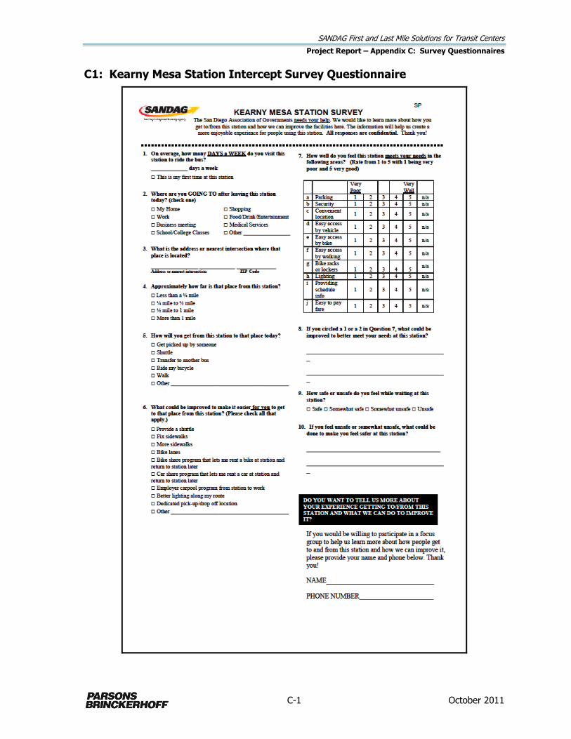
SANDAG First and Last Mile Solutions for Transit Centers
Project Report – Appendix C: Survey Questionnaires
C-1 October 2011
C1: Kearny Mesa Station Intercept Survey Questionnaire

SANDAG First and Last Mile Solutions for Transit Centers
Project Report – Appendix C: Survey Questionnaires
C-2 October 2011
C1: 32nd & Commercial Station Intercept Survey Questionnaire

SANDAG First and Last Mile Solutions for Transit Centers
Project Report – Appendix C: Survey Questionnaires
C-3 October 2011
C2. Kearny Mesa Station Web-based Survey Questionnaire
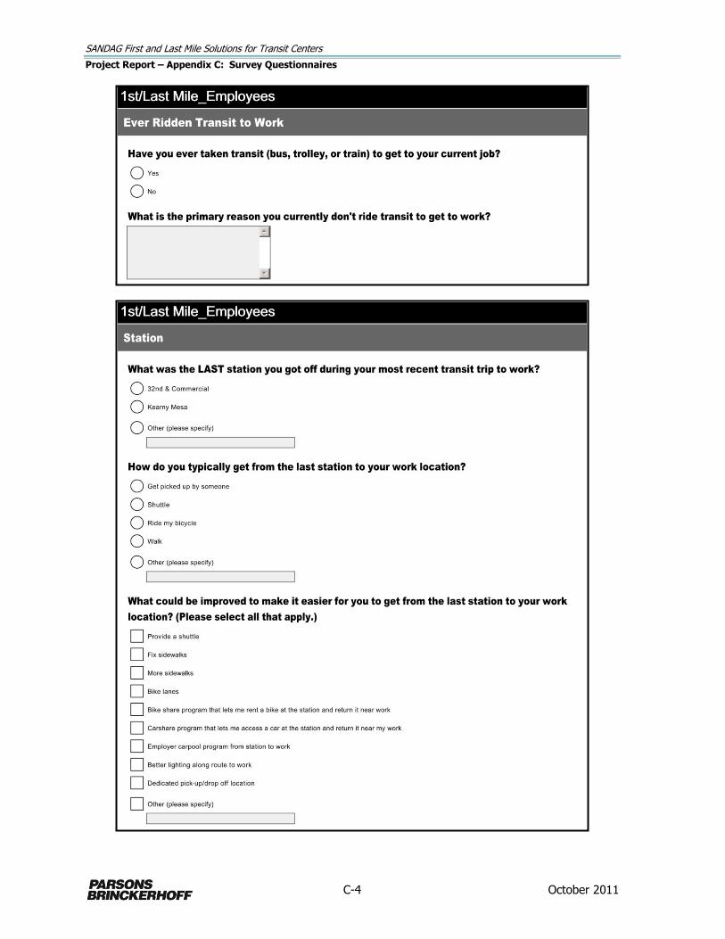
SANDAG First and Last Mile Solutions for Transit Centers
Project Report – Appendix C: Survey Questionnaires
C-4 October 2011

SANDAG First and Last Mile Solutions for Transit Centers
Project Report – Appendix C: Survey Questionnaires
C-5 October 2011
SANDAG First and Last Mile Solutions for Transit Centers
Project Report – Appendix C: Survey Questionnaires
C-6 October 2011
SANDAG First and Last Mile Solutions for Transit Centers
Project Report – Appendix C: Survey Questionnaires
C-7 October 2011
C2. 32nd & Commercial Station Web-Based Survey Questionnaire

SANDAG First and Last Mile Solutions for Transit Centers
Project Report – Appendix C: Survey Questionnaires
C-8 October 2011

SANDAG First and Last Mile Solutions for Transit Centers
Project Report – Appendix C: Survey Questionnaires
C-9 October 2011

SANDAG First and Last Mile Solutions for Transit Centers
Project Report – Appendix C: Survey Questionnaires
C-10 October 2011