sarasota 2050 resource management area (rma) policy
TRANSCRIPT

SARASOTA 2050 RESOURCE MANAGEMENT AREA (RMA) POLICY REVISITED
STAFF REPORT
September 24, 2013 Page 1 of 51
SUBJECT: Consideration of Sarasota 2050 RMA Policy Revisited
MEETING DATE: September 24, 2013
PREPARED BY: Planning and Development Services Department, Long Range Planning Division,
Zoning Administration Division, Natural Resources Department
PURPOSE This staff report presents recommendations on the issues within the first phase (which is limited to potential
changes to Zoning Code that do not require revising policy) of the Sarasota 2050 RMA Policy Revisited effort,
and requests authorization to post public notice for a public hearing on proposed amendments to the Zoning
Regulations.
BACKGROUND Through a series of workshops, the Sarasota County Commission (board) has acquired perspective from staff,
the public, and development stakeholders on issues/concerns related to processing and construction of projects
pursuant to Sarasota 2050 RMA policy (Chapter 9 of the Comprehensive Plan). The board subsequently
approved a refined scope of work document that combines and restates various comments and issues identified
and relating to policies and regulations that should be re-evaluated and possibly amended to encourage the
implementation of Sarasota 2050 RMA policy. This effort was directed to be pursued while maintaining
Sarasota 2050 RMA policy intended outcomes and fundamental values.
The scope of work for the Sarasota 2050 RMA Policy Revisited effort was organized within three phases as
related to the complexity of the issues involved. The first phase was to be pursued within a 4 to 6 month
timeframe, and included issues generally involving modifications to the Zoning Regulations that do not require
any Comprehensive Plan policy changes. The second and third phases were to be pursued within a 7 to 10
month and 10 to 14 month timeframes, respectively. The second phase involves policy changes
(Comprehensive Plan) that do not deviate significantly from the original fundamental values of 2050 policy,
and the third phase involves policy changes that may deviate from those values.
PREVIOUS BOARD ACTION January 26, 2011 - Board direction: Reassess Sarasota 2050 RMA (Resource Management Area) Plan
Requirements in an effort to maintain its original goals and intents.
September 18, 2012 - Board direction: meet with affected private sector development interests on Chapter 9,
Sarasota 2050 RMA policy of the Sarasota County Comprehensive Plan.
January 30, 2013 - Board direction: a) compile data on Sarasota 2050 RMA projects; b) engage the
community on Sarasota 2050 RMA policy; and c) prepare a draft scope of work document for initiation of
appropriate implementation action in response to input collected.
May 8, 2013 - Board direction: a) County Attorney to clarify any conflicts in the county's fiscal neutrality
requirement in relation to the recent Florida legislative action regarding proportionate share; b) waived the
‘scope of work review process’ and present a report back to the board within 60 days with a refined scope of
work document, timeline/schedule; and community engagement description; and c) the May 8, 2013 staff
report on Sarasota 2050 RMA policy be posted on the county's website and update the public comment section
on the "Revisiting Sarasota 2050" web page to include citizen name and address.
July 9, 2013 - Board direction: a) approved scope of work inclusive of issue OS-5; and b) authorized
proceeding with an economic consultant whose work product is to be reviewed by volunteers consisting of 3
individuals with banking and/or public finance experience with a report due back by December 2013.

SARASOTA 2050 RESOURCE MANAGEMENT AREA (RMA) POLICY REVISITED
STAFF REPORT
September 24, 2013 Page 2 of 51
TABLE OF CONTENTS Page
I. Sarasota 2050 RMA Policy Revisited: First phase ………………………… 3
A. Issues to be addressed within the 4 to 6 month timeframe.
B. Community Engagement.
C. First Phase Schedule.
II. Structure of Issue Reports ………………………………………………… 3
Open Space (OS) New Urbanism (NU)
III. OS-1: Timing of Conservation Easement (CE) ………………………….. 4
IV. NU-1a: Housing Types – Hamlets ……………………………………….. 9
V. NU-1b: Housing Types – Villages & Settlement Areas …………………. 16
VI. NU-2: Commercial Location Requirement ….............................................. 23
VII. NU-4: Allowance for Multiple Village Centers …………………………… 31
VIII. NU-11: Clarity of Density Granted ……………………………………… 35
IX. NU-13: Clarity in Dwelling Unit Derivation from TDR Table ………….. 41
X. Recommendation …………………………………………………………. 48
Appendices
Appendix ‘A’: Bibliography ……………………………………………… 51

SARASOTA 2050 RESOURCE MANAGEMENT AREA (RMA) POLICY REVISITED
STAFF REPORT
September 24, 2013 Page 3 of 51
I. Sarasota 2050 RMA Policy Revisited: First phase. The approved scope of work is presented here:
A. Issues to be addressed within the 4 to 6 month timeframe:
1. OS-1: Conservation Easement timing
2. NU-1: Housing Types
3. NU-2: Commercial Location
4. NU-4: Village Center Requirement
5. NU-11: Clarity of Density Granted
6. NU-13: Clarity in Dwelling Unit Derivation
B. Community Engagement:
1. Informational and educational material on proposed modifications will be made
available at the county’s 2050 web page on the county’s web site.
2. One public workshop will be conducted.
3. Local Planning Authority (LPA) review of proposed modifications at a public
hearing.
4. Board of County Commissioner’s public hearing on proposed modifications.
C. First Phase Schedule:
1. July 9, 2013 – Board approved scope of work.
2. September 24, 2013 – Board authorization to publicize for public hearing.
3. Early October 2013 – Public Workshop
4. Late October 2013 – Planning Commission Public Hearing
5. Mid November 2013 – Board Public Hearing / Action
II. Structure of Issue Reports A report has been prepared for each first phase issue pursuant to the following outline:
A. Issue Statement: Presents a brief summary statement of the issue being addressed with
an explanation as to how the issue affects 2050 policy implementation.
B. Issue Direction Proposed: Provides a concise statement describing the direction being
pursued that responds to the issue with a brief rationale for the proposed direction.
C. Relevant Policy & Regulatory Citations: Provides the full text of the relevant policy
and regulatory citations for the issue with an explanation as to why each is relevant.
D. Information Supporting Direction: Provides qualified supportive information utilized
within the analysis / deliberative process in consideration of the proposed direction.
E. Information Refuting Direction: Identifies information that may refute the proposed
direction to be addressed within the analysis.
F. Analysis of Information: Addresses both sides of the issue.
G. Conclusion: Summary statement as to how the proposed direction addresses the issue.
H. Proposed Regulatory Language Changes (if applicable): Presents the specific
modifications being proposed to be made to the regulatory text of the County Code.

SARASOTA 2050 RESOURCE MANAGEMENT AREA (RMA) POLICY REVISITED
STAFF REPORT
September 24, 2013 Page 4 of 51
III. OS-1: Timing of Conservation Easement (CE)
A. Issue Statement: Allow Conservation Easements (CEs) for Villages to be recorded
incrementally consistent with a master land use plan. Create consistent standards
regarding the timing of recording CEs for Villages, Hamlets, and Settlement Areas.
Currently, the regulatory provision for recording of the first CE within a 2050 Village
development is mandated for the entire Open Space land required for a 2000 acre Village.
The definitive boundary of the Open Space may not be known at the initial phase of a
multi-phased development, and there is very limited ability to remove/modify CEs once
they are recorded on a property.
B. Issue Direction Proposed: It is proposed that the Zoning Regulation be modified to
allow greater flexibility in the timing requirement for CE recordation, to allow a potential
reduction in the initial 1,000 acre CE recording. The acreage of the initial CE may be
allowed to be reduced to no less than 750 acres if priority is given to environmental
preservation and corridors within the initial CE recording so that there is adequate
assurance the long-term goal would be achieved.
C. Relevant Policy & Regulatory Citations:
c. Open Space Standards.
Zoning Regulation 11.2.9.
1. All open space shall be designated as Open Space on the Master Land Use
Plan. Open space may not be included in an individual lot, except for
caretaker residences in accordance with Section 11.2.5.f.1.i.(c).
2. Perpetual Easement: Open Space shall be preserved in perpetuity through the
use of a perpetual open space/conservation easement(s). The open
space/conservation easement(s) shall be in such form as is deemed acceptable
by the County Attorney consistent with the terms and provisions of these
regulations. In addition, the following criteria shall apply to the recording of
the required open space/conservation easements for Villages, Hamlets and
Settlement Areas:
i. Recording of Open Space/Conservation Easement(s) for Villages. An
initial open space/conservation easement shall be recorded for a
minimum 1,000 acres of Open Space within the proposed Village, as
reflected on the Master Land Use Plan for the property which is the
minimum amount of open space required to support a Village
Development. This 1,000 acres of Open Space will be the subject of the
initial open space/conservation easement following the final approval
of the Master Land Use Plan and in compliance with Section
11.2.13.g. below. The open space/conservation easement(s) for the
balance of the required Open Space as incrementally refined and
precisely defined through the subsequent Neighborhood Plans and
Subdivision/Site and Development Plans shall be incrementally
recorded at the time of each future Construction Plan approval and

SARASOTA 2050 RESOURCE MANAGEMENT AREA (RMA) POLICY REVISITED
STAFF REPORT
September 24, 2013 Page 5 of 51
prior to commencement of construction of the particular subdivision,
condominium, cooperative, rental project or village center.
ii. Recording of Open Space Conservation Easement(s) for Hamlets and
Settlements: The initial open space/conservation easement for a
Hamlet or Settlement shall include that portion of the required open
space within the proposed Hamlet or Settlement that is necessary to
support the first phase of development as reflected on the Master Land
Use Plan and as further refined through the Neighborhood Plan
process and shall be recorded at the time of construction plan
approval and prior to commencement of construction. The open
space/conservation easement(s) for the balance of the required open
space, as incrementally refined and precisely defined through the
subsequent Neighborhood Plans and Subdivision/Site and
Development Plans shall be incrementally recorded at the time of each
future Construction Plan approval and prior to commencement of
construction of the particular subdivision, condominium, cooperative,
rental project or phase of development.
Relevancy of Cited Policy/Regulations:
• 11.2.9.c.2.i requires an initial open space/conservation easement to be recorded
for a minimum 1,000 acres of Open Space within the proposed Village for the
property which is the minimum amount of open space required to support a
Village Development.
• 11.2.9.c.2.ii. allows for the initial open space/conservation easement for a Hamlet
or Settlement to include that portion of the required open space within the
proposed Hamlet or Settlement that is necessary to support the first phase of
development and is recorded at the time of construction plan approval and prior to
commencement of construction.
D. Information supporting direction:
1. Allowing incremental recording is already allowed for in Hamlets and Settlements
from the beginning of a project to be recorded prior to construction plan approval.
Allowing incremental recording for Villages is already allowed after the initial
1,000 acres is set aside following the final approval of the Master Land Use Plan.
2. Incrementally preserving native habitat areas through plats has generally been
successful as part of implementing the Palmer Ranch “East Side Analysis”.
3. The master land use and neighborhood plans are conceptual in nature, whereas the
limits of CEs are based on surveyed boundary lines. Native habitats such as
wetlands are typically not delineated and confirmed during the conceptual
planning phase of a project. Rather, wetlands and other native habitats are
delineated and then surveyed at the construction plan development phase.
4. Minor reasonable and practical adjustments to development plans that do not
negatively impact native habitat systems are common during the construction plan
development phase. Requiring recordation of a CE early in the conceptual phase
of the project may conflict with minor adjustments that will be needed.

SARASOTA 2050 RESOURCE MANAGEMENT AREA (RMA) POLICY REVISITED
STAFF REPORT
September 24, 2013 Page 6 of 51
5. The master land use plan, rezone and neighborhood plans provide some level of
assurance that open space and environmental areas will be set aside. An ‘F-2
map’ (a map identifying potential habitat preservation/mitigation/impact) that
designates habitat impacts, preservation and mitigation is required as part of the
DRI and DOCC processes, which provides some level of regulatory assurance or
a road map to the areas to be set aside.
E. Information refuting direction:
1. While the minimum 1,000 acres must be placed into a CE associated with the first
phase following the final approval of the Master Land Use Plan, successive CEs
associated with the other phases may be recorded incrementally, reasonably
allowing for adjustments in the conceptual CE boundaries.
2. One of the primary tenets of 2050 is that development proposals provide a higher
bar of open space and environmental protection as an incentive to receiving
substantial density and urban development forms. If a development is to receive
the benefits that 2050 provides, it is important to ensure that a significant portion
of the required open space to support a Village needs to be set aside from the
beginning.
3. Allowing incremental recording of CEs from the beginning of a project creates a
piecemeal approach that is less predictable, more difficult to enforce, and can lead
to a reduction in the quality of the overall open space and environmental areas.
4. Allowing incremental recording from the beginning does not take into account the
possibility that successive phases of development will not be built leaving the
required open space unpreserved or configured in a manner that does not achieve
the intended goals.
5. Requiring the CE to be recorded up-front promotes early and good planning of
meaningful open space and environmental systems.
6. While the Palmer Ranch “East Side Analysis” was generally successful, plats
were used rather than CEs to set aside the open space areas. CEs provide a
greater level of certainty than plats that the areas will be set aside in the long-term
as envisioned as part of 2050 planning.
7. Incrementally recording of CEs in smaller portions significantly increases the
administrative burdens and costs. There are over 20 increments to Palmer Ranch
and it is administratively challenging to manage conditions and stipulations for
each increment.
8. Specific documentation has not been presented to County staff that demonstrates
the existing requirement impedes implementation of 2050.
For the above-listed reasons, modification of the existing language may not be
necessary.
F. Analysis of information: While not a Village, an important factor to consider is the
success of the Palmer Ranch East Side Analysis. A Development of Regional Impact
(DRI) was approved for this development and there was an F-2 map that clearly set aside
via a regulatory document all of the open space and environmental areas as part of the
master land use plan. As each phase of the overall project came in, a plat was recorded
protecting environmental areas consistent with the F-2 map. This approach generally
SARASOTA 2050 RESOURCE MANAGEMENT AREA (RMA) POLICY REVISITED
STAFF REPORT
September 24, 2013 Page 7 of 51
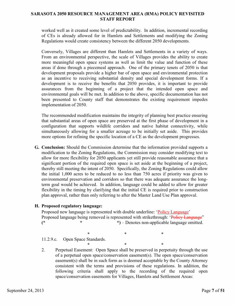
worked well as it created some level of predictability. In addition, incremental recording
of CEs is already allowed for in Hamlets and Settlements and modifying the Zoning
Regulations would create consistency between the different 2050 developments.
Conversely, Villages are different than Hamlets and Settlements in a variety of ways.
From an environmental perspective, the scale of Villages provides the ability to create
more meaningful open space systems as well as limit the value and function of these
areas if done through a piecemeal approach. One of the primary tenets of 2050 is that
development proposals provide a higher bar of open space and environmental protection
as an incentive to receiving substantial density and special development forms. If a
development is to receive the benefits that 2050 provides, it is important to provide
assurances from the beginning of a project that the intended open space and
environmental goals will be met. In addition to the above, specific documentation has not
been presented to County staff that demonstrates the existing requirement impedes
implementation of 2050.
The recommended modification maintains the integrity of planning best practice ensuring
that substantial areas of open space are preserved at the first phase of development in a
configuration that supports wildlife corridors and native habitat connectivity, while
simultaneously allowing for a smaller acreage to be initially set aside. This provides
more options for refining the specific location of a CE as the development progresses.
G. Conclusion: Should the Commission determine that the information provided supports a
modification to the Zoning Regulations, the Commission may consider modifying text to
allow for more flexibility for 2050 applicants yet still provide reasonable assurance that a
significant portion of the required open space is set aside at the beginning of a project,
thereby still meeting the intent of 2050. Specifically, the Zoning Regulations could allow
the initial 1,000 acres to be reduced to no less than 750 acres if priority was given to
environmental preservation and corridors so that there was adequate assurance the long-
term goal would be achieved. In addition, language could be added to allow for greater
flexibility in the timing by clarifying that the initial CE is required prior to construction
plan approval, rather than only referring to after the Master Land Use Plan approval.
H. Proposed regulatory language:
Proposed new language is represented with double underline: ‘Policy Language’
Proposed language being removed is represented with strikethrough: ‘Policy Language”
(* * *) – Denotes non-applicable language omitted.
* * *
11.2.9.c. Open Space Standards.
* * *
2. Perpetual Easement: Open Space shall be preserved in perpetuity through the use
of a perpetual open space/conservation easement(s). The open space/conservation
easement(s) shall be in such form as is deemed acceptable by the County Attorney
consistent with the terms and provisions of these regulations. In addition, the
following criteria shall apply to the recording of the required open
space/conservation easements for Villages, Hamlets and Settlement Areas:

SARASOTA 2050 RESOURCE MANAGEMENT AREA (RMA) POLICY REVISITED
STAFF REPORT
September 24, 2013 Page 8 of 51
i. Recording of Open Space/Conservation Easement(s) for Villages. An initial
open space/conservation easement shall be recorded for a minimum 1,000
acres of Open Space within the proposed Village, as reflected on the Master
Land Use Plan for the property which is the minimum amount of open space
required to support a Village Development. This 1,000 acres of Open Space
will be the subject of the initial open space/conservation easement following
the final approval of the Master Land Use Plan and prior to Construction Plan
approval, and in compliance with Section 11.2.13.g. below. As part of the
approval of the Master Land Use Plan, the initial 1,000 acre Conservation Easement
may be reduced to no less than 750 acres if it preserves, in order of priority,
designated Greenways, native habitats in major wildlife corridors, other open space
in major wildlife corridors, other native habitats, and other open space. The open
space/conservation easement(s) for the balance of the required Open Space as
incrementally refined and precisely defined through the subsequent
Neighborhood Plans and Subdivision/Site and Development Plans shall be
incrementally recorded at the time of each future Construction Plan approval
and prior to commencement of construction of the particular subdivision,
condominium, cooperative, rental project or village center.
* * *

SARASOTA 2050 RESOURCE MANAGEMENT AREA (RMA) POLICY REVISITED
STAFF REPORT
September 24, 2013 Page 9 of 51
Please note that the regulatory language and issues for housing types in Hamlets are
addressed within report NU-1a, separately from Village/Settlement Area housing types
because they are defined differently. The regulatory language and issues for housing types
are the same for the Villages and Settlement Areas, and therefore are addressed within
report NU-1b. References to “Village” shall include “Settlement Area” for report NU-1b.
IV. NU-1a: Housing Types - Hamlets.
A. Issue statement: Evaluate housing types including definitions, number of types, and
percentage of types required/allowed. Recommend options for providing flexibility in
provisions for housing types including the number of types, and percentage of types,
allowing additional housing types not defined, and options for administrative
modification to requirements.
The requirement for multiple housing types within Hamlets may be too prescriptive and
require a diversity and number of housing types that cannot be supported by the market
place, and may be inappropriate for the rural Hamlet locations. A 2050 developer must
be able to provide housing types for which there is a market demand, and in addition, be
able to change the housing types when the market demand changes.
B. Issue direction proposed: Of the three basic directions available (1-No change; 2-
Modify provisions; 3-Eliminate provisions), the recommendation is to modify the zoning
requirements to reduce the number of required housing types from three to two. This
proposed change will allow more flexibility to meet market demands and narrow the
range of required housing types to those appropriate to the rural Hamlet locations. This
would allow Hamlets to be developed with only housing (lot) types of near 1 acre or
larger. The change would maintain consistency with the rural character of the Hamlets
and their location by allowing development with larger lots and not require housing types
of an urban character.
Should the board choose not to follow the proposed direction stated above, the following
alternatives may be possible:
Modification Alternative - Eliminate required mix of housing types for Hamlets. The
recommended reduction from three to two required housing types removes the
requirement to provide some housing types of urban character, allowing Hamlets to be
developed only with housing of a rural character, consistent with policy VOS2.1.
However, at least 30% of the lots would still have to be less than one acre in size.
Eliminating entirely the requirements for housing type mix would allow the construction
of Hamlets consisting entirely of lots of one acre in size or greater and/or lots generally of
one size. This would not result in development much different in character that under the
changes as recommended.
No Change Alternative - Under the provisions of Section 11.3.11.e, the board, through
the rezoning and Master Development Plan process, may grant modification to any of
these provisions regarding number and percentage of housing types as requested by a
petitioner.

SARASOTA 2050 RESOURCE MANAGEMENT AREA (RMA) POLICY REVISITED
STAFF REPORT
September 24, 2013 Page 10 of 51
C. Relevant policy & regulatory citations:
Policy RMA1.1 Resource Management Area Ideals (RMA Ideals)
“Provide for a variety of land uses and lifestyles to support residents of diverse
ages, incomes, and family sizes, including housing that is affordable to residents
at or below the median income for Sarasota County.”
Policy VOS1.2b Hamlets
“Hamlets are collections of rural homes and lots clustered together around a
crossroads…”
Policy VOS1.3 Village/Open Space RMA Philosophy
“Neighborhoods form the basic building block for development within the
Village/Open Space RMA and are characterized by a mix of residential housing
types…”
Policy VOS1.4Village/Open Space RMA Principles
“Villages and Hamlets shall include a range of housing types that support a
broad range of family sizes and incomes.”
Policy VOS2.1(c)
The delineation between Village land use and Hamlet land use is hereby
established as depicted in Figure RMA-3. Villages may be developed only in
Village land use and Hamlets may be developed only in the Hamlet land use. This
delineation is based on the concept of a countryside line, defined as the
easternmost boundary of Village land use, as depicted in Figure RMA-3, which
supports a community vision to establish a clear transition from urban character
west of this delineation to rural character east of this delineation.

SARASOTA 2050 RESOURCE MANAGEMENT AREA (RMA) POLICY REVISITED
STAFF REPORT
September 24, 2013 Page 11 of 51
Relevancy of Cited Policy/Regulations:
These Comprehensive Plan policies of Sarasota 2050 clearly establish that
accommodating a broad range of family sizes and incomes in a variety of housing types
is a principal of the Village/Open Space RMA. However, the types of housing
appropriate for Hamlets is not specifically addressed, except that Policy VOS1.2.b states
that “Hamlets are collections of rural homes and lots clustered together around a
crossroads…”. In addition, Policy VOS2.1 speaks of the delineation between Village and
Hamlet land use. The delineation is based on the concept of a “country side line” which
supports a community vision to establish a clear transition from urban to rural character.
The urban character being that of the Villages to the west of the “country side line”, and
the rural character being that of the Hamlets to the east of it. The differences between the
two designations is codified through the zoning regulations for Hamlets that define only
five housing types, where the Village regulations define nine housing types. Excluded
from the Hamlet housing types are several of the Village housing types that have an
urban character such as apartment, live-work, or residential over non-residential.
However, the five Hamlet housing types do include attached housing types and housing
(lot) types of less than 10,000 square feet, both of which are arguably of urban character.
The Hamlet regulations require that three of the five housing types be provided in each
Hamlet, and in addition, no more than 70% of the housing structures in a Hamlet can be
of one type. The types of housing that may be provided in a Hamlet is also affected by
the minimum/maximum density range of 0.4 to 1 dwelling unit per acre of developed
area. There are no affordable housing requirements for a Hamlet.
D. Information supporting direction:
1. The requirement for a specific number or type of housing unit is not specified within
policy nor within the Charter of New Urbanism1
2. The need for a mix of housing types is identified within Ten Principles for Smart
Growth on the Suburban Fringe
published by the Congress of New
Urbanism. This organization is a leading promoter of the New Urbanism concept
that contains similar language already existing in 2050 policy: “Within neighborhoods,
a broad range of housing types and price levels can bring people of diverse ages, races,
and incomes into daily interaction, strengthening the personal and civic bonds essential
to an authentic community.”.
2
3. This mixed housing type requirement is again addressed within the American
Planning Association’s (APA) Planning Advisory Service (PAS) report “Codifying
New Urbanism”.
as published by the Urban Land Institute, a leading
non-profit educational and research organization that provides leadership in the use
of land in order to enhance the total environment. However, the referenced principal
again does not specify a number or type of housing unit beyond referencing the basic
categories of rental, single-family, townhouse, and multi-family. The mix of housing
types is also directed towards the mixed use village center where relatively higher
density levels are encouraged that would have readily accessible amenities.
3 PAS stems from the research department of the APA, a
professional organization providing leadership in the development of vital
communities. This publication once again does not go beyond the general need of
mixed housing types and does not specify a number or type of housing unit to be
included within a code. This publication does raise the issue of integrating

SARASOTA 2050 RESOURCE MANAGEMENT AREA (RMA) POLICY REVISITED
STAFF REPORT
September 24, 2013 Page 12 of 51
‘accessory dwellings’ within New Urbanism code to be allowed in detached garages
and possibly other accessory structures.
4. A critical overview of New Urbanism published within the Journal of Urban Design
entitled “The New Urbanism: Critiques and Rebuttals”4
5. Industry publications such as The Advisory by RCLCO, an established firm in real
estate advisory services, has questioned the overly prescriptive nature of Form-
Based codes such as those implementing New Urbanism. A recent article “Market
Pitfalls of Form-Based or Smart Codes”
once again only makes a
minor reference to mixed housing types as a component of the neighborhood
building block. While the article concludes that the principals of New Urbanism are
worthy of pursuit, it recognizes that it is a land development practice that has
research gaps that need to be filled. The various elements of New Urbanism continue
to evolve as additional evidence is available to examine.
5
6. The general direction that Smart Codes have approached the issue of diversity of
housing types within neighborhoods has been to assign minimum density levels for
neighborhoods, which currently exists for the 2050 forms of development. “The
Principles of Smart Development”
specifically questions the practice of
locking in design elements related to housing types because they infringe on the
flexibility that is needed to respond to market conditions and demand.
6
, a PAS report published by the APA describes
obstacles to Smart Growth development principles and suggested methods for
addressing them. Again, there is no suggested provision for prescribing a minimum
number of housing types.
E. Information refuting direction:
1. Actual housing demand may support more housing types rather than less according
to research conducted by the Fannie Mae Planning & Economic Strategic Research
Group as published within the Fannie Mae Housing Insights entitled “Rental
Resurgence Marked by Single-Family Expansion and Diverging Affordability Trends
for Owners and Renters”.7
2. An overall code drafting principle presented within the APA’s PAS report
“Codifying New Urbanism” suggests that certain code provisions may need to be
prescriptive rather than permissive. It is pointed out that for some elements of New
Urbanism, simply allowing it is insufficient assurance that development will
accomplish the intended goals. This concept was not specifically referencing
housing types, however it is the type of provision that might fall within the area
contemplated by the principle.
Indicators point towards a decline in homeownership
rates, and that housing affordability is growing more difficult for young renters,
while easing for young homeowners. As demand in the rental market expands, so
have housing costs for renters. Renters are now spending at least 30% of income for
housing which has increased every year between 2007 and 2011. In contrast, housing
costs for young homeowners have declined during the last four years. These findings
indicate a continuation of the growing housing demand for rental that has resulted
from the housing crisis and the Great Recession, which in turn will have an impact
on the housing market. However, while these indicators may support more diversity
in the housing market, lowering the number of housing types required does not
prevent a development from providing more housing types.

SARASOTA 2050 RESOURCE MANAGEMENT AREA (RMA) POLICY REVISITED
STAFF REPORT
September 24, 2013 Page 13 of 51
F. Analysis of information:
Current Hamlet Housing Types
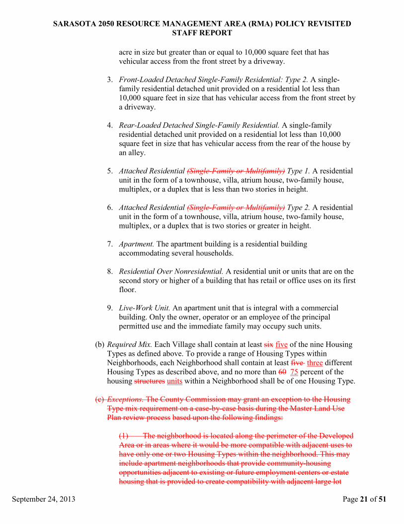
(a) Estate House. A single-family residential housing unit that is provided on a lot with
a minimum lot size of one acre.
(b) Front-Loaded Detached Single-Family Residential: Type 1. A single-family
residential detached unit provided on a residential lot less than one acre in size but
greater than or equal to 10,000 square feet that has vehicular access from the front
street by a driveway.
(c) Front-Loaded Detached Single-Family Residential: Type 2. A single-family
residential detached unit provided on a residential lot less than 10,000 square feet in
size that has vehicular access from the front street by a driveway.
(d) Rear-Loaded Detached Single-Family Residential. A single-family residential
detached unit provided on a residential lot less than 10,000 square feet in size that
has vehicular access from the rear of the house by an alley.
(e) Attached Residential (Single-Family). A single-family residential unit in the form
of a townhouse, villa, or atrium house.
Analysis of Existing Regulations
The housing types defined for a Hamlet include attached units and single family lots of
all sizes. Hamlets must provide three of the five housing types defined, with no more
than 70% of the units being of one type. There is no minimum number or percentage for
the other two required types. In addition to meeting the minimum requirements for
housing types and mix, and as part of the Master Development Plan, an applicant for the
HPD district must provide in tabular form, the number and type of units to be provided
within a Hamlet. Change in housing types (switching types, or changing the number of a
type) once a Master Development Plan has been adopted, is considered a minor
modification that can be approved by the Zoning Administrator. These minor
modifications would exclude locations within 100 feet of the project boundary, or a
change from single family to a multifamily type. Under the provisions of Section
11.3.11.e, the board may grant modification to any of these provisions regarding number
and percentage of housing types.
Analysis of Proposed Changes
As previously stated the Comprehensive plan policies of Sarasota 2050 clearly establish
that accommodating a broad range of family sizes and incomes in a variety of housing
types is a fundamental principle the Village/Open Space RMA. However, a reduction in
the required number of housing types in a Hamlet may still further these fundamental
principles, while providing additional design flexibility in the planning and development
of Hamlet projects. In addition, not requiring attached housing, or lots of less than
10,000 square feet would be consistent with desired rural character of Hamlet
developments.

SARASOTA 2050 RESOURCE MANAGEMENT AREA (RMA) POLICY REVISITED
STAFF REPORT
September 24, 2013 Page 14 of 51
Two of the three required housing types in Hamlets can be provided in lots sizes of
between 10,000 square feet and an acre, and lots one acre or greater in size. The third
housing type must be provided in lots of less than 10,000 square feet or attached units.
Because there is no minimum number or percentage required for the third, a reduction in
the number of housing types required would have little affect on housing diversity within
a Hamlet. A reduction in the number of housing types required from three to two types
would allow Hamlets to be developed in lots of near an acre or greater in size and not
require a developer to provide lots of less 10,000 square feet or attached units.
G. Conclusion: Reduce the number of housing types required to be provided within Hamlet
from three to two which addresses the need for flexibility in housing types and numbers,
while still meeting the intent of the Village/Open Space RMA Principles of the
Comprehensive Plan.
The proposed changes will provide a 2050 developer additional flexibility in providing
the number and percentage of required housing types. Section 11.3.15 of the 2050
regulations provides for administrative modification to changes in housing types as
shown on an approved Master Land Use Plan, and no additional modification provisions
are required.
H. Proposed regulatory language:
Proposed new language is represented with double underline: ‘Policy Language’
Proposed language being removed is represented with strikethrough: ‘Policy Language”
(* * *) – Denotes non-applicable language omitted.
* * *
Hamlet Housing Types.
i. Housing Types. For the purpose of determining compliance with the hamlet
requirements for providing a range of Housing Types within neighborhoods and
within each Hamlet, Housing Types are defined as follows:
(a) Estate House. A single-family residential housing unit that is provided on
a lot with a minimum lot size of one acre.
(b) Front-Loaded Detached Single-Family Residential: Type 1. A single-
family residential detached unit provided on a residential lot less than one
acre in size but greater than or equal to 10,000 square feet that has
vehicular access from the front street by a driveway.
(c) Front-Loaded Detached Single-Family Residential: Type 2. A single-
family residential detached unit provided on a residential lot less than
10,000 square feet in size that has vehicular access from the front street by
a driveway.
(d) Rear-Loaded Detached Single-Family Residential. A single-family
residential detached unit provided on a residential lot less than 10,000
square feet in size that has vehicular access from the rear of the house by

SARASOTA 2050 RESOURCE MANAGEMENT AREA (RMA) POLICY REVISITED
STAFF REPORT
September 24, 2013 Page 15 of 51
an alley.
(e) Attached Residential (Single-Family). A single-family residential unit in
the form of a townhouse, villa, or atrium house.
ii. Required Mix. Each Hamlet shall contain at least three of the five Housing Types
as defined above. To provide a range of Housing Types within Neighborhoods,
each Neighborhood shall contain at least two different Housing Types as
described above. No more than 70 percent of the housing structures units within a
Neighborhood Hamlet shall be of one Housing Type.
* * *
Note: This proposed language amendment removes reference to “neighborhoods”. This
language is in error as originally adopted. There are no neighborhood divisions in
Hamlets. The removal of this language is a clarification in the requirements.

SARASOTA 2050 RESOURCE MANAGEMENT AREA (RMA) POLICY REVISITED
STAFF REPORT
September 24, 2013 Page 16 of 51
V. NU-1b: Housing Types – Villages & Settlement Areas.
A. Issue statement: Evaluate housing types including definitions, number of types, and
percentage of types required/allowed. Recommend options for providing flexibility in
provisions for housing types including the number of types, and percentage of types,
allowing additional housing types not defined, and options for administrative
modification to requirements.
The requirement for multiple housing types within Villages and Neighborhoods may be
too prescriptive and require a diversity and number of housing types that cannot be
supported by the market place. A 2050 developer must be able to provide housing types
for which there is a market demand, and in addition, be able to change the housing types
when the market demand changes.
B. Issue direction proposed: Of the three basic directions available (1-No change; 2-
Modify provisions; 3-Eliminate provisions), the recommendation is to modify existing
regulatory language to reduce the number of housing types required for an entire Village,
and within Neighborhoods, and increase the percentage of a single housing type allowed
within Neighborhoods. These proposed changes will allow more flexibility to meet
market demands while still providing for a diversity of housing types. In addition, the
changes are consistent with the modifications granted to previously approved Village and
Settlement area Master Land Use Plans.
Should the board choose not to follow the proposed direction stated above, the following
alternatives may be possible:
Modification Alternative - Provide minimum and maximum criteria for housing types
within entire Village. The nine housing types can be combined into three classes of
similar types and a minimum and maximum percentage assigned to each class to be
provided within each Village. These criteria would assure that meaningful amounts of
each class of housing type would be provided as indicated by the following example:
Minimum Maximum
Single Family Detached - types 1 through 4 none 75%
Attached, Apartment – types 5 through 7 25 % none
Mixed use – type 8 and 9 5% none
No Change Alternative - Under the provisions of Section 11.3.11.e, the board, through
the rezoning and Master Development Plan process, may grant modification to any of
these provisions regarding number and percentage of housing types as requested by a
petitioner.
C. Relevant policy & regulatory citations:
Policy RMA1.1 Resource Management Area Ideals (RMA Ideals)
“Provide for a variety of land uses and lifestyles to support residents of diverse
ages, incomes, and family sizes, including housing that is affordable to residents
at or below the median income for Sarasota County.”

SARASOTA 2050 RESOURCE MANAGEMENT AREA (RMA) POLICY REVISITED
STAFF REPORT
September 24, 2013 Page 17 of 51
Policy US4.2 Settlement Principles
“Neighborhoods form the basic building block for development, characterized by
a mix of residential housing types…”
“A range of housing types that support a broad range of family sizes and
incomes.”
Policy VOS1.1 Intent
“The Village/Open Space RMA creates an opportunity for a new form of
development in Sarasota County to replace what has become known as Urban
Sprawl. This new development pattern shall:
• be formed around Neighborhoods that include a broad range of family sizes
and incomes in a variety of housing types…”
Policy VOS1.3 Village/Open Space RMA Philosophy
“Neighborhoods form the basic building block for development within the
Village/Open Space RMA and are characterized by a mix of residential housing
types…”
Policy VOS1.4Village/Open Space RMA Principles
“Villages and Hamlets shall include a range of housing types that support a
broad range of family sizes and incomes.”
Relevancy of Cited Policy/Regulations:
These Comprehensive Plan policies of Sarasota 2050 clearly establish that
accommodating a broad range of family sizes and incomes in a variety of housing types
within Villages is a fundamental principle of the Village/Open Space RMA. Though the
policies regarding diversity in housing types are general in their construction, their
principles are codified though very specific zoning regulations that define nine housing
types, and require that six of the nine be provided within each Village, and five of the
nine within each Neighborhood. In addition, no more than 60% of the housing structures
in a Neighborhood can be of one type. The diversity in housing types is also affected by
the minimum/maximum density allowed for a Village developed area, and the number of
affordable housing units required.
D. Information supporting direction: The same information as provided with issue NU-1a
(page 11).
E. Information refuting direction: The same information as provided with issue NU-1a
(page 12).
F. Analysis of information:
Current Village Housing Types
1. Estate House. A single-family residential housing unit that is provided on a
lot with a minimum lot size of one acre.
2. Front-Loaded Detached Single-Family Residential: Type 1. A single-family
residential detached unit provided on a residential lot less than one acre in size

SARASOTA 2050 RESOURCE MANAGEMENT AREA (RMA) POLICY REVISITED
STAFF REPORT
September 24, 2013 Page 18 of 51
but greater than or equal to 10,000 square feet that has vehicular access from
the front street by a driveway.
3. Front-Loaded Detached Single-Family Residential: Type 2. A single-family
residential detached unit provided on a residential lot less than 10,000 square
feet in size that has vehicular access from the front street by a driveway.
4. Rear-Loaded Detached Single-Family Residential. A single-family
residential detached unit provided on a residential lot less than 10,000 square
feet in size that has vehicular access from the rear of the house by an alley.
5. Attached Residential (Single-Family or Multifamily) Type 1. A residential
unit in the form of a townhouse, villa, atrium house, two-family house,
multiplex, or a duplex that is less than two stories in height.
6. Attached Residential (Single-Family or Multifamily) Type 2. A residential
unit in the form of a townhouse, villa, atrium house, two-family house,
multiplex, or a duplex that is two stories or greater in height.
7. Apartment. The apartment building is a residential building accommodating
several households.
8. Residential Over Nonresidential. A residential unit or units that are on the
second story or higher of a building that has retail or office uses on its first
floor.
9. Live-Work Unit. An apartment unit that is integral with a commercial
building. Only the owner, operator or an employee of the principal permitted
use and the immediate family may occupy such units.
Analysis of Existing Regulations
The housing types defined for a Village incorporate all types available in the market
place, ranging from multifamily to lots of greater than one acre in size, and include
housing types integrated into commercial buildings. For an entire village six of the nine
housing types defined must be provided. However, there is no minimum number or
percentage of any one type required. Within each neighborhood, five of the nine housing
types must be provided, with no more than 60% of the structures being of one housing
type. There is no minimum number or percentage for the other four required types. In
addition to meeting the minimum requirements for housing types and mix, an applicant
for the VPD district must provide in tabular form, the number and type of units to be
provided within a Village, and the range of housing types to be provided for each
Neighborhood and Village Center. This information becomes part of the binding Master
Development Plan. Change in housing types (switching types, or changing the number of
a type) once a Master Development Plan has been adopted, is considered a minor
modification that can be approved by the Zoning Administrator. These minor
modifications would exclude locations within 100 feet of the project boundary, or a
change from single family to a multifamily type.

SARASOTA 2050 RESOURCE MANAGEMENT AREA (RMA) POLICY REVISITED
STAFF REPORT
September 24, 2013 Page 19 of 51
Under the provisions of Section 11.3.11.e, the board may grant modification to any of
these provisions regarding number and percentage of housing types. Two of the
previously approved Master Development Plans for 2050 projects (The Villages of
Lakewood Ranch South and Blackburn Creek), were granted reductions in the number of
housing types provided in Neighborhoods from five to three types by the board.
Blackburn Creek was also granted a reduction in the number of housing types provided in
the entire Village from six to five, and an increase above the maximum 60% for one
housing type in neighborhoods. Blackburn Creek was also granted a modification that,
for the approved Master Development Plan, provided that changes to housing types
within 100 feet of the project boundary or changes of types from single family to
multifamily would be considered a minor modification, instead of major.
It should also be noted that the minimum density requirements of three units per acre of
developed area for a Village will also likely result in a diversity in housing types. A
development of entirely of 1/3 acre lots would not meet this minimum density
requirement, some of the units would have to be provided at a higher density. In
addition, the existing requirement that 15% of the units be provided in affordable housing
would likely provide availability of housing to a broad range of incomes and result in a
range of housing types that might not otherwise be provided.
Analysis of Proposed Changes
As previously stated, the Comprehensive plan policies of Sarasota 2050 clearly establish
that accommodating a broad range of family sizes and incomes in a variety of housing
types is an important principle of the Village/Open Space RMA. However, a reduction in
the required number of housing types in an entire Village development and within
neighborhoods, along with an increase in the maximum percentage of one housing type in
neighborhoods may still further these fundamental principles, while providing additional
design flexibility in the planning and development of Village projects.
Six of the nine types required for an entire Village
In that there is no minimum number or percentage required for each of the six housing
types required for an entire village, a reduction below the required six types will have a
small affect on housing diversity. The reduction in the requirement by one housing type
may result in only one or a few units of one housing type not being provided. Conversely,
providing one or a few units of a housing type is all that is needed to meet the
requirement. Reducing the number of housing types required within an entire Village
below six will provide additional flexibility in providing required housing types, and
likely have a small impact on the diversity of housing types within an entire Village.
Five of the nine types required within neighborhoods, with no more than 60% of one type
Though diversity of housing types is required for an entire Village, it is also required at
the neighborhood level. The reason for further requiring diversity in housing types in
individual neighborhoods can be found in one of the principles of the Charter of New
Urbanism. “Within neighborhoods, a broad range of housing types and price levels can
bring people of diverse ages, races, and incomes into daily interaction, strengthening the
personal and civic bonds essential to an authentic community.” Though similar to this
principle of New Urbanism, the policies Sarasota 2050 are limited to providing range of
housing types that support a broad range of family sizes and incomes. Though reducing

SARASOTA 2050 RESOURCE MANAGEMENT AREA (RMA) POLICY REVISITED
STAFF REPORT
September 24, 2013 Page 20 of 51
the requirement for diversity of housing within a neighborhood may provide less
opportunity for people of diverse ages, races and incomes to interact daily, it would not
obstruct the goal of providing range of housing types that support a broad range of family
sizes and incomes. Reducing the number of housing types required from five to three, and
increasing the percentage of a single housing type allowed within Neighborhoods will
allow additional flexibility in providing required housing types, and have a small impact
on the diversity of housing types within an entire Village.
G. Conclusion: Reduce the number of housing types required to be provided within an
entire Village from six to five. Reduce the number of housing types within a
neighborhood from five to three. Increase the maximum percentage of one housing type
in a Neighborhood from 60 to 75%. In addition, minor modifications to the definitions of
the housing types are proposed to be consistent with the housing type definitions within
Section 6.7 of the Zoning Ordinance. As a cleanup item, the “Exceptions” provision is
proposed to be deleted. It is duplicative and unnecessary in that Section 11.3.11.e of the
2050 regulations provides that the board may grant modifications to any of the provisions
as long as they are consistent with the Goals, Objectives and Policies of Sarasota 2050.
The proposed changes will provide a 2050 developer additional flexibility in providing
the number and percentage of required housing types, while still meeting the intent of the
Village/Open Space RMA Principles of the Comprehensive Plan. The housing types
defined incorporate all types available in the market place and no additional types are
needed. Section 11.3.15 of the 2050 regulations provides for administrative modification
to changes in housing types as shown on an approved Master Land Use Plan, and no
additional modification provisions are required.
H. Proposed regulatory language:
Proposed new language is represented with double underline: ‘Policy Language’
Proposed language being removed is represented with strikethrough: ‘Policy Language”
(* * *) – Denotes non-applicable language omitted.
* * *
iv. Village Housing Type Mix.
(a) Housing Types. For the purpose of determining compliance with the village
requirements for providing a range of Housing Types within neighborhoods
and within each Village, Housing Types are defined as follows:
Note: The following four changes are proposed to establish consistency with those definitions
provided for within Section 6 of the Zoning Code and apply to both Village and Settlement
Area zoning provisions.
1. Estate House. A single-family residential detached housing unit that is
provided on a lot with a minimum lot size of one acre.
2. Front-Loaded Detached Single-Family Residential: Type 1. A single-
family residential detached unit provided on a residential lot less than one
SARASOTA 2050 RESOURCE MANAGEMENT AREA (RMA) POLICY REVISITED
STAFF REPORT
September 24, 2013 Page 21 of 51
acre in size but greater than or equal to 10,000 square feet that has
vehicular access from the front street by a driveway.
3. Front-Loaded Detached Single-Family Residential: Type 2. A single-
family residential detached unit provided on a residential lot less than
10,000 square feet in size that has vehicular access from the front street by
a driveway.
4. Rear-Loaded Detached Single-Family Residential. A single-family
residential detached unit provided on a residential lot less than 10,000
square feet in size that has vehicular access from the rear of the house by
an alley.
5. Attached Residential (Single-Family or Multifamily) Type 1. A residential
unit in the form of a townhouse, villa, atrium house, two-family house,
multiplex, or a duplex that is less than two stories in height.
6. Attached Residential (Single-Family or Multifamily) Type 2. A residential
unit in the form of a townhouse, villa, atrium house, two-family house,
multiplex, or a duplex that is two stories or greater in height.
7. Apartment. The apartment building is a residential building
accommodating several households.
8. Residential Over Nonresidential. A residential unit or units that are on the
second story or higher of a building that has retail or office uses on its first
floor.
9. Live-Work Unit. An apartment unit that is integral with a commercial
building. Only the owner, operator or an employee of the principal
permitted use and the immediate family may occupy such units.
(b) Required Mix. Each Village shall contain at least six five of the nine Housing
Types as defined above. To provide a range of Housing Types within
Neighborhoods, each Neighborhood shall contain at least five three different
Housing Types as described above, and no more than 60 75 percent of the
housing structures units within a Neighborhood shall be of one Housing Type.
(c) Exceptions. The County Commission may grant an exception to the Housing
Type mix requirement on a case-by-case basis during the Master Land Use
Plan review process based upon the following findings:
(1) The neighborhood is located along the perimeter of the Developed
Area or in areas where it would be more compatible with adjacent uses to
have only one or two Housing Types within the neighborhood. This may
include apartment neighborhoods that provide community-housing
opportunities adjacent to existing or future employment centers or estate
housing that is provided to create compatibility with adjacent large lot

SARASOTA 2050 RESOURCE MANAGEMENT AREA (RMA) POLICY REVISITED
STAFF REPORT
September 24, 2013 Page 22 of 51
residential development.
(2) The applicant has demonstrated that the granting of the
exception(s) does not adversely affect the ability of the Village
development as a whole to meet the intent of the Village/Open Space
RMA Principles as defined in the Sarasota County Comprehensive Plan,
Sarasota 2050 Policies.
(3) The exception does not permit more than 20 percent of the total
housing stock within a Village to be located in a neighborhood that has
only one housing type.
* * *

SARASOTA 2050 RESOURCE MANAGEMENT AREA (RMA) POLICY REVISITED
STAFF REPORT
September 24, 2013 Page 23 of 51
VI. NU-2 Commercial Location Requirement.
A. Issue statement: Evaluate requirement that a Village or Neighborhood Center must be
centrally located in a Village development. Recommend Village Center location options
including the perimeter of Village development and along existing adjacent arterials.
This analysis and recommendation addresses Village Centers and their required location.
Neighborhood Centers and Hamlet Focal Points, which may have commercial
components, can be located anywhere within the Neighborhoods and Hamlets and are not
addressed. The regulatory language and issues for Village Centers are the same for the
Villages (VPD, Village Planned Development) and Settlement Areas (SAPD, Settlement
Area Planned Development). For the purpose of this report regarding Village Centers,
“Village” will also mean “Settlement Area”.
The requirement that a Village Center be located near the center of a Village and not near
or at the edge of a developed area may hinder its success and vitality by inhibiting
visibility and access for users other than Village residents. In addition, locations at the
edge of a Village and close to existing arterials would provide more direct and convenient
vehicular and transit access to both Village residents and outside users.
B. Issue direction proposed: Of the three basic directions available (1-No change; 2-
Modify provisions; 3-Eliminate provisions), the recommendation is to modify existing
regulatory language to allow Village Centers to be located anywhere within the
developed area of a Village, provided that they interface with adjacent Village
neighborhoods and are easily accessible to Village residents.
The Village Center along with entire developed area of a Village (VPD district) would
still be subject to the Greenbelt requirements that will separate a Village Center from
other properties or adjacent roadways by a minimum of 500 feet, with some areas
requiring up to 1,400 feet. Modifications to the Greenbelt requirements must be
addressed through the Comprehensive Plan amendment process. Settlement Areas
(SAPD district) are not subject to Greenbelt requirements.
No change
Under the provisions of Section 11.3.11.e, the board, through the rezoning and Master
Development Plan process, may grant modification to any of these provisions regarding
location of Village Centers.
C. Relevant policy & regulatory citations:
Policy VOS1.2a Villages
“Villages shall be supported by internally designed, mixed-use Village Centers
(designed specifically to serve the daily and weekly retail, office, civic, and
government use and services needs of Village residents) …”
Policy VOS 1.4 Village Open/Space RMA Principles “Villages shall include a Village Center with sufficient non-residential uses to
provide for the daily needs of Village residents, by phase of development, in a form

SARASOTA 2050 RESOURCE MANAGEMENT AREA (RMA) POLICY REVISITED
STAFF REPORT
September 24, 2013 Page 24 of 51
that is conveniently served by regional bus service”
Policy US4.2 Settlement Principles
“A mix of uses, including residential, commercial, office, Public/Civic, schools,
and Recreational Space, that provides for most of the daily needs of residents
shall be located within the Settlement, or within a maximum of 5 miles of each
Neighborhood Center, and shall be accessible to all residents of the Settlement;”
Relevancy of Cited Policy/Regulations:
These Comprehensive Plan policies of 2050 do not provide clear guidance or direction on
Village Center location. Policy 1.2.a describes the Village Center as being “internally
designed", but the meaning of this phrase is unclear and seems to be clarified to mean
“designed specifically to serve the daily and weekly retail, office, civic, and government use
and services needs of Village residents”. The term “internally designed” is also applied to
Neighborhood Centers, however, there are no restrictions on the location of these
commercial centers within Neighborhoods. In addition, Policy VOS 1.4 states that
Village Centers shall be in a form that “is conveniently served by regional bus service”.
This would suggest that a location close to existing or planned arterial roadways would
be appropriate. Also, though the policies clearly state that Village Centers must serve the
needs of Village residents, there is no language that would preclude a Village Center
from serving the needs of those other than Village residents.
D. Information supporting direction:
1. LEED 2009 for Neighborhood Development Rating System, Created by the Congress
for the New Urbanism, Natural Resources Defense Council, and the U.S. Green
Building Council, from “Neighborhood Development” the “center” need not be in the
geographic center of the neighborhood; it can be along the edge, on an arterial or
transit line.
2. New Urbanism projects reviewed for commercial center locations:
• Mesa Del Sol, Albuquerque, N.M.,
• Mountain House, San Joaquin County, California,
• Robert Meuller Airport Reuse Plan, Austin, Texas,
• North West Crossing, Bend, Oregon,
• Mt. Laurel, Shelby County, Alabama.
E. Information refuting direction: No information that may refute the proposed direction
has been identified.
F. Analysis of information: The Village Center is intended to include a mix of commercial,
office, residential and civic uses that identifies and defines a Village and functions as its
center. Its design, vitality and success are essential to the 2050 Village concept, and
should be facilitated through the zoning regulations.
The Village Center Locational Requirements of the zoning ordinance require that “a
Village Center shall be separated from the edge of the Developed Area by at least one
neighborhood and by no less than 1,700 feet and shall be centrally located in the Village
development”. The ordinance also states that “although the Village Center need not be in

SARASOTA 2050 RESOURCE MANAGEMENT AREA (RMA) POLICY REVISITED
STAFF REPORT
September 24, 2013 Page 25 of 51
the exact geographic center of the Village, it shall in general be located near that center
and may not be located at or near the an edge of the Developed Area or Greenbelt where
applicable.” Under the provisions of Section 11.3.11.e, the board may grant modification
to any of these provisions regarding the location of Village Centers. For the previously
approved 2050 project Blackburn Creek, the board granted a modification to the
locational requirements allowing the Village Center to be located at the perimeter of the
developed area along River Road.
The Comprehensive Plan or background information related to the creation of 2050
policy and regulations do not provide the actual rationale for these locational
requirements. It is likely that the intent was to implement the idea that the purpose of a
Village Center was to serve only the residents of the Village, and patronage or use by
those other than Village residents was to be discouraged by the locational requirements.
This idea is reflected in the standards for commercial development within Sarasota
County’s PUD (Planned Unit Development) district, adopted in 1972. These standards
state that “Commercial uses located in a PUD are intended to serve the needs of the PUD
and not the needs of a surrounding area”. The standards further state that “Areas
designated for commercial activities shall be oriented towards the interior of the project
and shall not be located on exterior or perimeter streets or property boundaries, but shall
be centrally located within the project to serve the residents of the PUD.” However, as
stated earlier, the Policies of 2050 related to Village Centers would not preclude the use
or patronage of Village Centers by those other than the residents of the Village, or a
location at the edge of a Village that may encourage such use.
The examination of other large scale master planned developments similar to Sarasota
2050 Villages provided no examples where commercial centers were restricted to the
interior of development. Many examples reviewed had commercial centers located near
or at the periphery of development, usually along existing arterial roadways.
The Congress for the New Urbanism and the Natural Resources Defense Council
collaborated with the U.S. Green Building Council in creating the LEED for
Neighborhood Development Rating System. The system is designed to certify exemplary
development projects that perform well in terms of smart growth, urbanism, and green
building. Projects may constitute whole neighborhoods, portions of neighborhoods, or
multiple neighborhoods. In introductory discussion of neighborhood or commercial
centers, it is stated that “The “center” need not be in the geographic center of the
neighborhood; it can be along the edge, on an arterial or transit line.”
G. Conclusion: Remove the Village locational requirement that states “A Village Center
shall be separated from the edge of the Developed Area by at least one neighborhood and
by no less than 1,700 feet and shall be centrally located in the Village development.
Although the Village Center need not be in the exact geographic center of the Village, it
shall in general be located near that center and may not be located at or near an edge of
the Developed Area or Greenbelt where applicable.”, while still meeting the intent of the
Village/Open Space RMA Principles of the Comprehensive Plan.
Replace this language to address the need for flexibility in locating Village Centers with
“A Village Center is intended to serve the daily and weekly retail, office, civic, and

SARASOTA 2050 RESOURCE MANAGEMENT AREA (RMA) POLICY REVISITED
STAFF REPORT
September 24, 2013 Page 26 of 51
government use and services needs of Village residents, and shall be located and
designed so as to be easily accessible by all Village Residents”.
In addition, the staff proposes to add a sixth locational standard that states that the Village
Center shall be located within the Village in a manner that “Supports compact Village
development, with interconnected streets that are designed to balance the needs of all
modes of transportation; interfaces with adjacent Village neighborhoods and provides
residents with safe and easy access to the Village Center that is designed with a
pedestrian orientation.”
Also, because the meaning of the phrase “internally designed” is unclear, it needs to be
removed where it appears in relation to Village Centers,
These proposed changes will permit a Village Center to be located anywhere within a
Village developed area, allowing the location to be based on geographic criteria and
market influences that will best insure a vibrant and successful Village Center.
H. Proposed regulatory language:
Proposed new language is represented with double underline: ‘Policy Language’
Proposed language being removed is represented with strikethrough: ‘Policy Language”
(* * *) – Denotes non-applicable language omitted.
* * *
11.2.3. Village Planned Development District (VPD) Zoning Standards.
b. Description of Form. A Village is a collection of Neighborhoods that have been
designed so that a majority of the housing units are within a walking distance or
one-quarter mile radius of a Neighborhood Center. A Village shall be supported
by one internally designed,
Neighborhoods form the basic building block for development within the VPD.
Neighborhoods are characterized by a mix of residential housing types that are
distributed on a connected street system. The majority of housing is within a
walking distance or one-quarter mile radius of a Neighborhood Center.
a mixed-use Village Center (designed specifically to
serve the daily and weekly retail, office, and Public/Civic use and services needs
of Village residents), and the Village shall generally be surrounded by large
expanses of Open Space that are designed to protect the character of the rural
landscape and provide separation between the Village and existing low density
rural development. An example illustration of this form is provided in Figure
VOS-1.
* * *
d. Village Center Requirements.
1. Village Center Size. Maximum Size: 100 acres.
2. Village Center Locational Requirements. A Village Center shall be
separated from the edge of the Developed Area by at least one
neighborhood and by no less than 1,700 feet and shall be centrally located
in the Village development. Although the Village Center need not be in the

SARASOTA 2050 RESOURCE MANAGEMENT AREA (RMA) POLICY REVISITED
STAFF REPORT
September 24, 2013 Page 27 of 51
exact geographic center of the Village, it shall in general be located near
that center and may not be located at or near an edge of the Developed Area
or Greenbelt where applicable. (See Figure VOS-1)
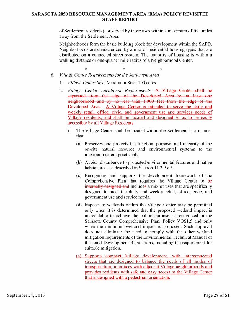
i. The Village Center shall be located within the Village in a manner that:
A Village Center is
intended to serve the daily and weekly retail, office, civic, and government
use and services needs of Village residents, and shall be located and
designed so as to be easily accessible by all Village Residents.
(a) Preserves the function, purpose, and integrity of the on-site natural
resource and environmental systems to the maximum extent
practicable.
(b) Avoid disturbance to protected environmental features and native
habitat areas as defined in Section 11.2.9.c.5.
(c) Recognizes and supports the development framework of the
Comprehensive Plan that requires that the intensity of development
and human use increase incrementally with the distance from the
Greenway RMA.
(d) Recognizes and supports the development framework of the
Comprehensive Plan that requires that the Village Center is
internally designed and
(e) Impacts to wetlands within the Village Center may be permitted
only when it is determined that the proposed wetland impact is
unavoidable to achieve the public purpose as recognized in the
Sarasota County Comprehensive Plan, Policy VOS1.5 and only
when the minimum wetland impact is proposed. Such approval
does not eliminate the need to comply with the other wetland
mitigation requirements of the Environmental Technical Manual of
the Land Development Regulations, including the requirement for
suitable mitigation.
includes a mix of uses that are specifically
designed to meet the daily and weekly retail, office, civic, and
government use and service needs.
(f) Supports compact Village development, with interconnected
streets that are designed to balance the needs of all modes of
transportation; interfaces with adjacent Village neighborhoods and
provides residents with safe and easy access to the Village Center
that is designed with a pedestrian orientation.
* * *
11.2.4. Settlement Area Planned Development District (SAPD) Zoning Standards.
b. Description of Form. The Settlement Area is required to be designed in the form
of a village which is a collection of Neighborhoods that have been designed so
that a majority of the housing units are within a walking distance or one-quarter
mile radius of a Neighborhood Center. The Settlement Area may be supported
by one internally designed a, mixed-use Village Center (designed specifically to
serve the daily and weekly retail, office, and Public/Civic use and services needs
SARASOTA 2050 RESOURCE MANAGEMENT AREA (RMA) POLICY REVISITED
STAFF REPORT
September 24, 2013 Page 28 of 51
of Settlement residents), or served by those uses within a maximum of five miles
away from the Settlement Area.
Neighborhoods form the basic building block for development within the SAPD.
Neighborhoods are characterized by a mix of residential housing types that are
distributed on a connected street system. The majority of housing is within a
walking distance or one-quarter mile radius of a Neighborhood Center.
* * *
d. Village Center Requirements for the Settlement Area.
1. Village Center Size. Maximum Size: 100 acres.
2. Village Center Locational Requirements. A Village Center shall be
separated from the edge of the Developed Area by at least one
neighborhood and by no less than 1,000 feet from the edge of the
Developed Area.
i. The Village Center shall be located within the Settlement in a manner
that:
A Village Center is intended to serve the daily and
weekly retail, office, civic, and government use and services needs of
Village residents, and shall be located and designed so as to be easily
accessible by all Village Residents.
(a) Preserves and protects the function, purpose, and integrity of the
on-site natural resource and environmental systems to the
maximum extent practicable.
(b) Avoids disturbance to protected environmental features and native
habitat areas as described in Section 11.2.9.c.5.
(c) Recognizes and supports the development framework of the
Comprehensive Plan that requires the Village Center to be
internally designed and includes
(d) Impacts to wetlands within the Village Center may be permitted
only when it is determined that the proposed wetland impact is
unavoidable to achieve the public purpose as recognized in the
Sarasota County Comprehensive Plan, Policy VOS1.5 and only
when the minimum wetland impact is proposed. Such approval
does not eliminate the need to comply with the other wetland
mitigation requirements of the Environmental Technical Manual of
the Land Development Regulations, including the requirement for
suitable mitigation.
a mix of uses that are specifically
designed to meet the daily and weekly retail, office, civic, and
government use and service needs.
(e) Supports compact Village development, with interconnected
streets that are designed to balance the needs of all modes of
transportation; interfaces with adjacent Village neighborhoods and
provides residents with safe and easy access to the Village Center
that is designed with a pedestrian orientation.

SARASOTA 2050 RESOURCE MANAGEMENT AREA (RMA) POLICY REVISITED
STAFF REPORT
September 24, 2013 Page 29 of 51
* * *
11.2.5. Permitted Uses. Permitted use descriptions and limitations are determined by the
Zoning Ordinance of Sarasota County Florida, which descriptions are hereby
adopted by this reference.
f. Limited Use Standards.
4. Commercial Use Standards.
i. Bed and Breakfast. A bed and breakfast is permitted in accordance with
the use table in Section 11.2.5.e, subject to the following standards:
(a) The building shall maintain a residential character, style and
appearance.
(b) The property shall meet the parking requirement of one on-site,
off-street parking space for every guest unit plus one space for the
manager. No variances from this requirement shall be permitted.
(c) Use of the property for a bed and breakfast shall meet all
applicable building and fire codes.
ii. Commercial Parking in Neighborhood Centers. Commercial parking is
permitted within a Neighborhood Center limited to serve only those
uses provided in that specific Neighborhood Center.
iii. Commercial Uses in Neighborhood Centers and Focal Points.
Commercial uses are permitted within Neighborhood Centers in either
Village or Settlement Areas and Hamlet Focal Points in accordance
with the use table in Section 11.2.5.e, subject to the following
standards:
(a) The sum of commercial uses within a Neighborhood Center shall
not exceed 20,000 square feet of gross floor area, and the sum of
commercial uses within a Hamlet focal point shall not exceed
10,000 square feet of gross floor area.
(b) Where two Neighborhood Centers are co-located as permitted in
subsection 11.2.3.e.3.ii and subsection 11.2.4.e.3.ii., the sum of the
commercial uses shall not exceed 40,000 square feet.
(c) The Commercial Uses are internally
designed to specifically serve
the needs of that Neighborhood or Hamlet.
* * *
11.2.7. Village and Settlement Area General Design Standards Including Standards for
Neighborhood Centers, Village Centers and Town Centers.
3. General Site Design Standards.
i. Village Center. A Village Center shall be separated from the edge of
the Development Area by at least one neighborhood and by no less than
1,700 feet and shall be centrally located in the Village development.
Although the Village Center need not be in the exact geographic center

SARASOTA 2050 RESOURCE MANAGEMENT AREA (RMA) POLICY REVISITED
STAFF REPORT
September 24, 2013 Page 30 of 51
of the Village, it shall in general be located near that center and may
not be located at or near an edge of the Developed Area. There shall be
no more than one Village Center within a Village.
(a) The Village Center shall be located within the Village in a manner
that:
A Village Center is
intended to serve the daily and weekly retail, office, civic, and
government use and services needs of Village residents, and shall be
located so as to be easily accessible by all Village Residents.
(1) Preserves the function, purpose, and integrity of the on-site
natural resource and environmental systems to the maximum
extent practicable.
(2) Minimizes disturbance to significant environmental features
and native habitat areas.
(3) Recognizes and support the development framework of the
Comprehensive Plan that requires that the intensity of
development and human use increase incrementally with the
distance from the Greenway RMA.
(4) Recognizes and supports the development framework of the
Comprehensive Plan that requires that requires that the Village
Center is internally designed and
(5) Impacts to wetlands within the Village Center may be
permitted only when it is determined that the proposed
wetland impact is unavoidable to achieve the public purpose
as recognized in the Sarasota County Comprehensive Plan,
Policy VOS1.5 and only when the minimum wetland impact is
proposed. Such approval does not eliminate the need to
comply with the other wetland mitigation requirements of the
Environmental Technical Manual of the Land Development
Regulations, including the requirement for suitable mitigation.
includes a mix of uses that
are specifically designed to meet the daily and weekly retail,
office, civic, and government use and service needs.
(6) Supports compact Village development, with interconnected
streets that are designed to balance the needs of all modes of
transportation; interfaces with adjacent Village neighborhoods
and provides residents with safe and easy access to the Village
Center that is designed with a pedestrian orientation.
* * *

SARASOTA 2050 RESOURCE MANAGEMENT AREA (RMA) POLICY REVISITED
STAFF REPORT
September 24, 2013 Page 31 of 51
VII. NU-4 Allowance for Multiple Village Centers.
A. Issue statement: Determine if a Village should continue to be limited to one Village
Center, or should there be multiple Village Centers allowed within a single Village.
The regulatory language and issues for Village Centers are the same for the Villages
(VPD, Village Planned Development) and Settlement Areas (SAPD, Settlement Area
Planned Development). For the purpose of this report regarding Village Centers,
“Village” will also mean “Settlement Area”.
There may be geographic or market conditions where more than one Village Center per
Village may be appropriate.
B. Issue direction proposed: Of the three basic directions available (1-No change; 2-
Modify provisions; 3-Eliminate provisions), the recommendation is to modify existing
regulatory language to allow for more than one Village Centers where an applicant can
demonstrate a geographical or market need.
No change
Under the provisions of Section 11.3.11.e, the board, through the rezoning and Master
Development Plan process, may grant modification to any of these provisions regarding
the number of Village Centers.
C. Relevant policy & regulatory citations:
Policy VOS1.2a Villages
“Villages shall be supported by internally designed, mixed-use Village Centers
(designed specifically to serve the daily and weekly retail, office, civic, and
government use and services needs of Village residents) …”
Policy VOS 1.4 Village Open/Space RMA Principles
“Villages shall include a Village Center with sufficient non-residential uses to
provide for the daily needs of Village residents, by phase of development, in a
form that is conveniently served by regional bus service”
Policy US4.2 Settlement Principles
“A mix of uses, including residential, commercial, office, Public/Civic, schools,
and Recreational Space, that provides for most of the daily needs of residents
shall be located within the Settlement, or within a maximum of 5 miles of each
Neighborhood Center, and shall be accessible to all residents of the Settlement;”
Policy VOS1.2.a Villages
Provides a maximum acreage (100 acres), a maximum size (300,000 gross
leasable square feet), and a minimum size (50,000 gross leasable square feet).
These maximums would apply to all Village Centers, and the minimum to
individual Village Centers, should multiple centers be allowed.

SARASOTA 2050 RESOURCE MANAGEMENT AREA (RMA) POLICY REVISITED
STAFF REPORT
September 24, 2013 Page 32 of 51
D. Information supporting direction:
1. LEED 2009 for Neighborhood Development Rating System, Created by the Congress
for the New Urbanism, Natural Resources Defense Council, and the U.S. Green
Building Council.8
From “Neighborhood Development” “A neighborhood should have places where the
public feels welcome and encouraged to congregate, recognizable as the heart of the
community. A proper center has at least one outdoor public space for this purpose,
designed with pedestrians in mind; this is the most well-defined outdoor “room” in
the neighborhood. The best centers are within walking distance of the primarily
residential areas, and typically some gradient in density is discernible from center to
edge.”
2. The Charter for New Urbanism.
“Concentrations of civic, institutional, and commercial activity should be embedded
in neighborhoods and districts, not isolated in remote, single-use complexes.”
E. Information refuting direction: No conflicting information identified.
1. Mixed-use development in practice is fraught with increased complexity and risk at
each stage of the development process. Moreover, those complexities and difficulties
differ for each project, and consequently, mixed-use development does not lend itself
to the formulaic approach that many single-use real estate products enjoy. (Georgia
Institute of Technology)9
2. While there may be synergy between retail tenants and office tenants, no such
synergy exists on the residential side. In residential complexes, retail tenants often
face significant negotiation hurdles relating to: signage, hours of operation, noise and
music, control over loitering customers and odors. (Cole Shotz)
10
F. Analysis of information: The Village Center is intended to include a mix of commercial,
office, residential and civic uses that identifies and defines a Village and functions as its
center. Its design, vitality and success are essential to the 2050 Village concept, and
should be facilitated through the zoning regulations.
The 2050 zoning regulations require that there be no more than one Village Center within
a Village that can include from 50,000 to 300,000 square feet of non-residential uses.
Neighborhood Centers (there can be multiple Neighborhood Centers) can have up to
20,000 square feet of non-residential uses. Generally, no more than one Village Center
may be appropriate for a Village development. Dividing the non-residential and higher
density residential components that make up a Village Center and support a Village
development may lead to the market need for multiple Village Centers that would
function at lower levels than a single center. In addition, two Neighborhood Centers can
be combined to allow construction of up to 40,000 square feet of commercial/office uses.
These neighborhood centers can provide alternative and secondary locations for Village
Center uses if needed.
However, there may be geographical or market conditions where it would be appropriate
to have more than one Village Center location. These circumstances may include larger
project sizes where only one Village Center would result in excessive distances between
Village residents and a Village Center.
1

SARASOTA 2050 RESOURCE MANAGEMENT AREA (RMA) POLICY REVISITED
STAFF REPORT
September 24, 2013 Page 33 of 51
G. Conclusion: Modify the requirement for the number of Village Centers to read “There
shall be no more than one Village Center within a Village unless the applicant can
demonstrate that there is a market need for additional centers, and the centers meet all
other location requirements.” This proposed change will permit more than one Village
Center within a Village where an applicant can demonstrate a market need. The change
will address the need for flexibility in planning for Village Centers, while still meeting
the intent of the Village/Open Space RMA Principles of the Comprehensive Plan.
H. Proposed regulatory language:
Proposed new language is represented with double underline: ‘Policy Language’
Proposed language being removed is represented with strikethrough: ‘Policy Language”
(* * *) – Denotes non-applicable language omitted.
* * *
11.2.3. Village Planned Development District (VPD) Zoning Standards.
a. Purpose and Intent Statement. The VPD District provides an area for coordinated
mixed-use developments which include Neighborhoods, each comprised of a broad
range of residential housing types, one Neighborhood Centers per Neighborhood,
Recreational Space, schools, and one
The VPD District allows residential uses, including multifamily residential communities
or upper story and attached residential dwelling units, in order to promote live-work and
mixed use opportunities. When rezoning to the VPD District, Master Land Use Plans
are binding. The VPD District is used to implement the Comprehensive Plan within
those areas of Sarasota County shown as Village Land Use within the Village/Open
Space RMA on the Future Land Use Map Series, Figure RMA-3.
Village Centers that includes residential,
commercial, office, Public/Civic uses, and Public Space within a planned development.
Each VPD District has appropriate perimeter buffering and Open Space that is achieved
through the Transfer of Development Rights and density bonus programs. The variety
of land uses available in this district will allow flexibility to respond to market demands
and the needs of tenants and residents, which provides for a variety of physically and
functionally integrated land uses.
b. Description of Form. A Village is a collection of Neighborhoods that have been
designed so that a majority of the housing units are within a walking distance or one-
quarter mile radius of a Neighborhood Center. A Village shall be supported by one
internally designed,
Neighborhoods form the basic building block for development within the VPD.
Neighborhoods are characterized by a mix of residential housing types that are
distributed on a connected street system. The majority of housing is within a walking
distance or one-quarter mile radius of a Neighborhood Center.
a mixed-use Village Center (designed specifically to serve the daily
and weekly retail, office, and Public/Civic use and services needs of Village residents),
and the Village shall generally be surrounded by large expanses of Open Space that are
designed to protect the character of the rural landscape and provide separation between
the Village and existing low density rural development. An example illustration of this
form is provided in Figure VOS-1.

SARASOTA 2050 RESOURCE MANAGEMENT AREA (RMA) POLICY REVISITED
STAFF REPORT
September 24, 2013 Page 34 of 51
* * *
d. Village Center Requirements.
* * *
3. Number of Village Centers. There shall be no more than one Village Center within
a Village.
* * *
, unless the applicant can demonstrate that there is a market need for
additional centers, and the centers meet all other location requirements.
11.2.4. Settlement Area Planned Development District (SAPD) Zoning Standards.
a. Purpose and Intent Statement. The SAPD District provides an area for some lands
within the Future Urban Area to provide for coordinated mixed-use developments
which include at least one Neighborhood, each comprised of a broad range of
residential housing types, Recreational Space, and one Neighborhood Centers per
Neighborhood
The SAPD District allows residential uses, including multifamily residential
communities or upper story and attached residential dwelling units, in order to promote
live-work and mixed use opportunities. When rezoning to the SAPD District, Master
Land Use Plans are binding. The SAPD District is used to implement the
Comprehensive Plan within those areas of Sarasota County shown as Settlement Area
on Figure RMA-1 of the Future Land Use Map Series, which land includes those areas
shown on Figure 9-12 of the Apoxsee Future Land Use Map Series.
, and an option for a Village Center that includes residential, commercial,
office, Public/Civic uses and Public Space within a planned development. In addition,
the Settlement Area recognizes the close proximity of nonresidential uses and urban
residential development that exists adjacent to each Settlement Area Development and
will allow for some flexibility in standards, such as buffering.
b. Description of Form. The Settlement Area is required to be designed in the form of a
village which is a collection of Neighborhoods that have been designed so that a
majority of the housing units are within a walking distance or one-quarter mile radius of
a Neighborhood Center. The Settlement Area may be supported by one internally
designed
Neighborhoods form the basic building block for development within the SAPD.
Neighborhoods are characterized by a mix of residential housing types that are
distributed on a connected street system. The majority of housing is within a walking
distance or one-quarter mile radius of a Neighborhood Center.
a, mixed-use Village Center (designed specifically to serve the daily and
weekly retail, office, and Public/Civic use and services needs of Settlement residents),
or served by those uses within a maximum of five miles away from the Settlement Area.
* * *
d. Village Center Requirements for the Settlement Area.
* * *
3. Number of Village Centers. Generally There shall be no more than one Village
Center within a Settlement Area.
* * *
, unless the applicant can demonstrate that there is
a market need for additional centers, and the centers meet all other location
requirements.

SARASOTA 2050 RESOURCE MANAGEMENT AREA (RMA) POLICY REVISITED
STAFF REPORT
September 24, 2013 Page 35 of 51
VIII. NU-11: Clarity of Density Granted.
A. Issue statement: Clarify the Zoning Code provisions that specify residential density
entitlement for Hamlet and Village designated properties because it is not readily
apparent how existing Policy has been carried out by the current regulatory language.
B. Issue direction proposed: Of the three basic directions available (1-No change; 2-
Modify provisions; 3-Eliminate provisions), the recommendation is to modify existing
regulatory language to clearly provide for the assignment of density for Villages and
Hamlets pursuant to existing policy.
The proposal is to extract the dwelling unit entitlement element that has been
incorporated within Table TDR-1 “Development Rights”, and replace it with Zoning
Regulations that entitle residential density for Hamlet and Village designated properties
similar to the way that density entitlement language was provided for on Settlement Area
designated properties. This is proposed to be done while maintaining the established
policy regarding the level of entitled residential density for property with Hamlet and
Village designations. This change will provide the residential density that a property
starts with, prior to adding residential density through the Transfer of Development
Rights (TDRs) mechanism, required for Hamlet and Village development. The intent
being that this is being proposed for clarification purposes only, and therefore the
calculated entitled residential density would remain un-changed.
C. Relevant policy & regulatory citations:
Policy VOS1.2 “Village/Open Space RMA: Development Framework”
“… Development densities greater than the underlying Rural or Semi-Rural
densities may only be achieved through the Transfer of Development Rights in
accordance with Objective TDR1, TDR2, and the associated policies.”
Policy US4.1 “Incentives for Development within Urban/Suburban Settlement Areas”
“… The property will be entitled to develop a maximum of two dwelling units per
gross acre if these units are transferred into the Developed Area in accordance
with an approved Master Development Plan. …” The Zoning Regulation
applicable to Settlement Areas already addresses this under Section 11.2.4.c.
“General District Requirements”, which implements the policy with the same
language as stated within Policy US4.1. Therefore, the entitled residential density
is 2.0DU/gross area acre to be located within the Developed Area of an approved
Master Development Plan at the time that Settlement Area Planned Development
(SAPD) zoning is granted.
Relevancy of Cited Policy/Regulations:
The “General District Requirements” Sections 11.2.2.c. and 11.2.3.c. for Hamlet and
Village designated properties respectively would be modified to include language that
addresses the entitled residential density in the same manner as those properties
designated Settlement Area.

SARASOTA 2050 RESOURCE MANAGEMENT AREA (RMA) POLICY REVISITED
STAFF REPORT
September 24, 2013 Page 36 of 51
D. Information supporting direction: Addressing this issue does not involve changing
policy direction, only involving clarification of existing regulatory language. Any
proposed modification to the regulatory language is a clarification of existing policy to
facilitate a better understanding of the subject matter by the general public and
implementation by staff. Therefore additional research to identify supportive information
for any proposed modifications is not required.
E. Information refuting direction: There is no substantive change in direction being
proposed.
F. Analysis of information: According to Policy VOS1.2, “…Development densities
greater than the underlying Rural or Semi-Rural densities may only be achieved through
the Transfer of Development Rights in accordance with Objective TDR1, TDR2, and the
associated polices…”. This policy was implemented with the transfer rate assignment
provided within Zoning Regulation Section 11.2.13.e. “Table TDR-1 Development
Rights” (Table TDR-1). For clarification purposes, it needs to be noted that the gross area
(GA) of any 2050 project is divided into the two basic categories of Developed Area
(DA) and Open Space (OS) area.
Table TDR-1 assigned residential density through the provision of a ‘transfer rate’ of
0.29DU per Developed Area (DA) acre for a 2050 project. The other transfer rates listed
within Table TDR-1 (0.0DU to 2.0DU per Open Space (OS) acre) depend upon the
existing land characteristics / proposed uses of the OS area. Each OS transfer rate was
assigned based on the relative value that was placed on the various land characteristics /
proposed uses by Policy TDR 1.3. Together, the 0.29DU per DA acre transfer rate and
the 0.0DU to 2.0DU per OS acre transfer rate make up the total number of DUs that a
2050 project is entitled to for the entire GA. Additional DUs must be derived from off-
site sources to meet the minimum/maximum density requirements/allowances for a 2050
project.
The ‘transfer rate’ assignment of 0.29DU/DA acre is the only ‘transfer rate’ assigned to
the DA. This presents a conflict in that the 0.29DU/DA acre does not actually get
‘transferred’ from one property to another, but rather stays on the DA lands. It is a
misnomer to label the 0.29DU/DA acre as a ‘transfer rate’ because it is not being moved
from one property to another, which is fundamental to the TDR concept. “Sending
Zones” and “Receiving Zones” are mutually exclusive under the terms of the TDR
provisions, and a single site cannot serve as both a sending and receiving site. The net
result of a single site being both a sending and receiving site is zero due to the
fundamental TDR concept that for each TDR unit being received on a site, there must be
a TDR unit permanently eliminated on a sending site.
G. Conclusion: The proposed modifications to the Zoning Code do not represent a change
to existing policy and would clearly address the assignment of residential density to the
Village and Hamlet forms of 2050 development. The new regulatory language carries out
the existing policy by inserting the 0.29DU/DA acre density assignment within the
“General District Requirements” for Villages and Hamlets. The required companion
modification is to extract this density assignment from Table TDR-1 by the deletion of
the 0.29DU/acre transfer rate for ‘Developed land in village’.

SARASOTA 2050 RESOURCE MANAGEMENT AREA (RMA) POLICY REVISITED
STAFF REPORT
September 24, 2013 Page 37 of 51
H. Proposed regulatory language:
Proposed new language is represented with double underline: ‘Policy Language’
Proposed language being removed is represented with strikethrough: ‘Policy Language”
(* * *) – Denotes non-applicable language omitted.
* * *
11.2. Village, Hamlet and Settlement Area Regulations.
* * *
11.2.2. Hamlet Planned Development District (HPD) Zoning Standards.
a. Purpose and Intent Statement. The HPD District provides for detached
residential uses, protected open space, Public/Civic uses and limited neighborhood
type commercial. The district is not commercial in character. When rezoning to the
HPD, Master Land Use Plans are binding. The HPD District is used to implement
the Comprehensive Plan within those areas of Sarasota County shown as Hamlet
Land Use within the Village/Open Space RMA on the Future Land Use Map
Series, Figure RMA-3.
b. Description of Form. Hamlets are collections of rural homes and lots clustered
together around a crossroads that may include small-scale commercial,
Public/Civic buildings or shared amenities. An example illustration of this form is
provided in Figure VOS-2.
c. General District Requirements.
1. Residential Density.
i. Hamlets are entitled to a base residential density of 0.29
dwelling units per acre of Developed Area. Additional density
may be obtained only by transfer from sending zones outside of the
Developed Area of the Hamlet and/or from sending zones on other
properties, under the Transfer of Development Rights program.
ii. Required Minimum Density within Developed Area: 0.4 du /
gross acres of Developed Area.
iii. Maximum Density allowed within Developed Area: 1 du/gross
acres of Developed Area.
COMMENTARY: These ‘Residential Density’ provisions follow the 2050 tenet
that additional residential density beyond which has been identified above for a
property is not granted without removing that density from another property to
facilitate the protection of Open Space.
2. Nonresidential. Commercial/Retail/Office Maximum Size: 10,000 gross
leasable square feet.
3. Open Space.
i. A minimum open space of 60 percent is required. This open
space shall be designated as Open Space on the Master Land Use
Plan, and shall not contain individual residential lots, except that a
caretaker residence in accordance with Section 11.2.5.f.1.i.(c) shall
be permitted. At their discretion, the County Commission may

SARASOTA 2050 RESOURCE MANAGEMENT AREA (RMA) POLICY REVISITED
STAFF REPORT
September 24, 2013 Page 38 of 51
permit Greenway RMA lands within a Hamlet Master Land Use
Plan to satisfy all or part of the Open Space requirement provided
that any Transfer of Development Rights that are created for
transfer to Receiving Zones outside the Hamlet Master Land Use
Plan are extinguished.
ii. Size and Location:
(a) Size: The minimum size of a Hamlet shall be
determined through the Master Land Use Plan Process.
(b) Maximum Size: 400 dwelling units.
(c) Preferred Size: 50 to 150 dwelling units.
iii. Focal Point:
(a) Locational Requirements: The Focal Points of adjacent
Hamlets shall be located at least 4,000 feet apart. Focal
Points shall be located within a one-quarter mile radius or
Walking Distance for the majority of the residences within
a Hamlet.
(b) Minimum Size: 5 acres.
* * *
11.2.3. Village Planned Development District (VPD) Zoning Standards.
a. Purpose and Intent Statement. The VPD District provides an area for
coordinated mixed-use developments which include Neighborhoods, each
comprised of a broad range of residential housing types, one Neighborhood Center
per Neighborhood, Recreational Space, schools, and one Village Center that
includes residential, commercial, office, Public/Civic uses, and Public Space
within a planned development. Each VPD District has appropriate perimeter
buffering and Open Space that is achieved through the Transfer of Development
Rights and density bonus programs. The variety of land uses available in this
district will allow flexibility to respond to market demands and the needs of
tenants and residents, which provides for a variety of physically and functionally
integrated land uses.
The VPD District allows residential uses, including multifamily residential
communities or upper story and attached residential dwelling units, in order to
promote live-work and mixed use opportunities. When rezoning to the VPD
District, Master Land Use Plans are binding. The VPD District is used to
implement the Comprehensive Plan within those areas of Sarasota County shown
as Village Land Use within the Village/Open Space RMA on the Future Land Use
Map Series, Figure RMA-3.
b. Description of Form. A Village is a collection of Neighborhoods that have been
designed so that a majority of the housing units are within a walking distance or
one-quarter mile radius of a Neighborhood Center. A Village shall be supported by
one internally designed, mixed-use Village Center (designed specifically to serve
the daily and weekly retail, office, and Public/Civic use and services needs of
Village residents), and the Village shall generally be surrounded by large expanses
of Open Space that are designed to protect the character of the rural landscape and
provide separation between the Village and existing low density rural

SARASOTA 2050 RESOURCE MANAGEMENT AREA (RMA) POLICY REVISITED
STAFF REPORT
September 24, 2013 Page 39 of 51
development. An example illustration of this form is provided in Figure VOS-1.
Neighborhoods form the basic building block for development within the VPD.
Neighborhoods are characterized by a mix of residential housing types that are
distributed on a connected street system. The majority of housing is within a
walking distance or one-quarter mile radius of a Neighborhood Center.
c. General District Requirements.
1. Residential Density.
i. Villages are entitled to a base residential density of 0.29
dwelling units per acre of Developed Area. Additional density
may be obtained only by transfer from sending zones outside of
the Developed Area of the Village and/or from sending zones on
other properties, under the Transfer of Development Rights
program.
i. ii. Required Minimum Density within Developed Area: 3
du/Gross Developable Acre.
ii. iii. Target Density: 6 du/Net Residential Acre.
iii. iv. Maximum Density allowed within Developed Area: 5 du/
Gross Developable Acre or 6 du/Gross Developable Acre if the
additional units are Affordable Housing Units.
v. Residential Density is calculated for the entire development site
Development Area and not for each individual neighborhood.
COMMENTARY: These ‘Residential Density’ provisions follow the 2050 tenet that
additional residential density beyond which has been identified above for a
property is not granted without removing that density from another property to
facilitate the protection of Open Space.
* * *
11.2.13. Transfer of Development Rights.
* * *
e. Calculation of Transferable Development Rights. The Development Rights
appurtenant to a particular parcel of land in a designated Sending Zone shall be
determined according to Table TDR-1:

SARASOTA 2050 RESOURCE MANAGEMENT AREA (RMA) POLICY REVISITED
STAFF REPORT
September 24, 2013 Page 40 of 51
TABLE TDR-1
DEVELOPMENT RIGHTS
Within Greenway RMA Within Village/Open Space RMA
LAND CHARACTERISTICS
High dry scrub 2 DU/acre 2 DU/acre
Xeric hammock
1.90 DU/acre 1.90 DU/acre
Dry prairie 1.80 DU/acre 1.80 DU/acre
Pine flatwood 1.80 DU/acre 1.80 DU/acre
Mesic hammock
1.80 DU/acre 1.80 DU/acre
Streams, estuaries
1.65 DU/acre 1.65 DU/acre
Freshwater wetlands 1.65 DU/acre 1.65 DU/acre
PROPOSED USE OF LAND
Potable water storage facilities
1.65 DU/acre 1.65 DU/acre
Existing and new passive public parks N/A 1.0 DU/acre
Existing rangeland, improved pasture, citrus and row crops, nursery operations, silviculture
1.0 DU/acre 1.0 DU/acre
Existing low intensity agriculture
.86 DU/acre .86 DU/acre
New low intensity agriculture
.86 DU/acre .86 DU/acre
New agriculture that uses best management practices
N/A .86 DU/acre
New hiking/natural resource recreation/boardwalks
.86 DU/acre .86 DU/acre
Existing high intensity agriculture
.57 DU/acre .57 DU/acre
Lakes and regional stormwater facilities
.57 DU/acre .57 DU/acre
New active public parks N/A .57 DU/acre
Developed land in village N/A .29 DU/acre
Golf courses N/A 0 DU/acre
* * *

SARASOTA 2050 RESOURCE MANAGEMENT AREA (RMA) POLICY REVISITED
STAFF REPORT
September 24, 2013 Page 41 of 51
IX. NU-13: Clarity in Dwelling Unit Derivation from TDR Table.
A. Issue statement: Calculating the transfer of development rights for a 2050 project (from
on-site and from off-site sources) lack clarity for the general public, and should be re-
written so that the provisions are more easily understood.
B. Issue direction proposed: Of the three basic directions available (1-No change; 2-
Modify provisions; 3-Eliminate provisions), the recommendation is to modify existing
regulatory language explaining the derivation of density through the established Transfer
of Development Right (TDR) program pursuant to existing policy.
The TDR program’s regulatory language within Zoning Code Section 11.2.13.e.
“Transfer of Development Rights” needs to include explanatory text referencing the basis
for the assigned TDR transfer rates within Table TDR-1 “Development Rights” (Table
TDR-1) and how the rates are to be applied. Additionally, an introduction should be
added to the existing ‘special considerations’ provisions that currently grant ‘bonus’
TDRs under certain circumstances.
C. Relevant policy & regulatory citations: Policy TDR1.3 “Density Assignment for Sending Zones”
The County shall adopt amendments to the Zoning Ordinance and Land
Development Regulations that establish the assignment of density rights available
for transfer within the established Sending Zones. The maximum total density
rights (i.e., number of potential dwelling units) available for transfer from all
lands within the Village/Open Space RMA, and the Greenway RMA will range
from a minimum of 0 Density Credits per acre to a maximum of 2 Density Credits
per acre and will be equal to the total number of acres in these two RMAs. The
assignment of density rights will not be uniform for all types of land, but will be
based upon an established set of criteria that provides incentives to meet Village
and Hamlet development goals and disincentives for activities that detract from
these goals. The greatest Density Credits will be assigned to areas that reinforce
the goals and intent of Village and Hamlet development including preserving
Native Habitat in areas with environmental significance. The amendments to the
Zoning Ordinance and Land Development Regulations shall be adopted within
two years of the effective date of the Sarasota 2050 RMA-1 Comprehensive Plan
Amendment. The proposed ordinance amending the Zoning Ordinance and Land
Development Regulations shall be prepared for public hearing within one year of
the effective date of the Sarasota 2050 RMA-1 Comprehensive Plan Amendment.
The following rankings will be used, in combination with the special
considerations enumerated below, to determine Density Credits.

SARASOTA 2050 RESOURCE MANAGEMENT AREA (RMA) POLICY REVISITED
STAFF REPORT
September 24, 2013 Page 42 of 51
Golf courses shall not be eligible for Density Credits.
Special considerations that may be evaluated to determine the overall value of the
Density Credit assigned to any specific property will include:
• Preservation and creation of a connected Greenway RMA;
• Preservation of important roadway corridor viewsheds;
• Proximity of developed areas to the Urban Service Area Boundary with
particular emphasis on proximity to the Economic Development RMA and
Major Employment Centers; and
• Market value of property.
Density Credits will be enhanced for properties that maximize the achievement of
these considerations and Density Credits will be reduced for properties that fail
to achieve or inhibit the achievement of these considerations.

SARASOTA 2050 RESOURCE MANAGEMENT AREA (RMA) POLICY REVISITED
STAFF REPORT
September 24, 2013 Page 43 of 51
Relevancy of Cited Policy/Regulations:
These Comprehensive Plan polices provide the basis for the TDR transfer rates assigned
within Table TDR-1 of the Zoning Code.
D. Information supporting direction: Addressing this issue does not involve changing
policy direction, only involving clarification of existing regulatory language. Any
proposed modification to the regulatory language is a clarification of existing policy to
facilitate a better understanding of the subject matter by the general public. Therefore
additional research to identify supportive information for any proposed modifications is
not required.
E. Information refuting direction: There is no substantive change in direction being
proposed.
F. Analysis of information: The TDR program’s regulatory language within Zoning Code
Section 11.2.13.e. “Transfer of Development Rights” currently has a very limited
introduction paragraph for Table TDR-1. Inserting an explanatory paragraph would assist
with understanding how the transfer rates were derived from Policy TDR 1.3, and how
they are applied. This would also assist with an overall understanding of the main
concept of Sarasota 2050 RMA Policy, which is to consolidate as many of the residential
units east of the USB as possible closer to Interstate 75 where development can be served
on a more efficient basis and establishes permanent Open Space in the process. This
overall concept depends on a finite number of residential units being redistributed
through the use of TDRs, which only allows an increase in residential density on a
property (receiving site) if it is removed from another property (sending site).
Additionally, adopted Zoning Code Table TDR-1 has 5 different ‘Proposed Use of Land’
categories that deal with agriculture. The distinction between these various categories can
be vague in that a property may fall into more than one of these categories. This
contributes to the confusion related to the tables application. The category of ‘Existing
rangeland, improved pasture, citrus and row crops, nursery operations, silviculture’
(referenced category) includes a broad range of agricultural activity. This makes it
difficult to classify the use of land solely within any of the other listed categories due to
them all falling within the referenced category. This referenced category was not within
Policy TDR 1.3, which is the basis for the transfer rates assigned with Table TDR-1. The
‘New low intensity agricultural’ category was also not within Policy TDR 1.3, and
neither of these categories were assigned a ranking. Therefore, to bring Table TDR-1
back in alignment with adopted Policy TDR 1.3 requires the deletion of these two
categories.
A further adjustment is required for the transfer rate assigned to ‘Existing and new
passive public parks’. This category was assigned a ranking of ‘5’ within Policy TDR 1.3
along with the categories of ‘Existing low intensity agriculture’ and ‘New hiking/natural
resource recreation/boardwalks’. Yet, as Policy 1.3 was carried forward into
implementation within Zoning Code Table TDR-1, ‘Existing and new passive public
parks’ was given a TDR transfer rate of 1.0 DU/acre while the later two categories were
given a TDR transfer rate of 0.86 DU/acre. Having been assigned the same ranking of ‘5’

SARASOTA 2050 RESOURCE MANAGEMENT AREA (RMA) POLICY REVISITED
STAFF REPORT
September 24, 2013 Page 44 of 51
within Policy TDR 1.3, it would follow that the TDR transfer rate given to each of these
categories by Table TDR-1 should be the same.
Similarly, category ‘New agricultural that uses best management practices’ was assigned
a ranking of ‘6’ by Policy TDR 1.3, and given a TDR transfer rate of 0.86 DU/acre by the
Zoning Code Table TDR-1. The categories of ‘Existing high intensity agriculture’,
‘Lakes and regional stormwater facilities’, and ‘New active public parks’ were all
assigned a ranking of ‘6’ by Policy TDR 1.3, and yet they were given a TDR transfer rate
of 0.57 DU/acre by Table TDR-1. Again, to eliminate confusion, all categories assigned
the ranking of ‘6’ should be given the same TDR transfer rate by Table TDR-1.
Therefore, the TDR transfer rate for the category of ‘Existing and new passive public
parks’ should be given 0.86 DU/acre, and the TDR transfer rate of 0.57 DU/acre should
be given to the category of ‘New agriculture that uses best management practices’
pursuant to existing Policy TDR 1.3.
G. Conclusion: The proposed modifications to the Zoning Code do not represent a change
to existing policy, and actually bring the Zoning Code into alignment with existing
policy. It now also will include an explanation for how the transfer rates within Table
TDR-1 were derived and how they are applied within 2050 projects. These proposed
modifications are also supported by the regulatory language modifications proposed
pursuant to issue NU-11, which deletes the 0.29DU/acre transfer rate for ‘Developed land
in village’ from Table TDR-1. Table TDR-1, as proposed to be modified, would now
only provide for the actual transferring of TDR units, rather than a mixing of concepts as
currently exists within the table.
H. Proposed regulatory language: Provided below-
Proposed new language is represented with double underline: ‘Policy Language’
Proposed language being removed is represented with strikethrough: ‘Policy Language”
(* * *) – Denotes non-applicable language omitted.
* * *
11.2.13. Transfer of Development Rights.
* * *
e. Calculation of Transferable Development Rights. The following assigned
transfer rates implement Policy TDR 1.3 “Density Assignment for Sending Zones”.
These transfer rates reflect the incentive density range provided for by Policy TDR
1.3 from 0.0DU to 2.0DU per acre. Each listed category under ‘Land
Characteristics’ have been assigned the higher values for existing natural habitat
conditions within the Open Space area being protected pursuant to an approved
Master Land Use Plan or those lands protected by the County in accordance with
Policy TDR 1.2. Each listed category under ‘Proposed Use of Land’ have been
assigned lower values for proposed uses of land within the Open Space area being
protected pursuant to an approved Master Land Use Plan or those lands protected
by the County in accordance with Policy TDR 1.2.
The Development Rights appurtenant to a particular parcel of land in a designated
Sending Zone shall be determined according to Table TDR-1:


SARASOTA 2050 RESOURCE MANAGEMENT AREA (RMA) POLICY REVISITED
STAFF REPORT
September 24, 2013 Page 46 of 51
The Development Rights appurtenant to a particular parcel of land in a designated
Sending Zone as determined by Table TDR-1 may be augmented by the following
special considerations subject to the stated qualifications and limitations:
1. In the event that the Sending Site would preserve, expand, or enhance a
Greenway or create a connection between areas of the Greenway RMA,
the number of Development Rights available for transfer from the Sending
Site shall be increased by the number of units obtained by multiplying the
total of units determined from Table TDR-1 by .10.
2. In the event that the Sending Site would enhance or preserve a viewshed
along Fruitville Road, Clark Road/SR 72, or Verna Road, the number of
Development Rights available for transfer from the Sending Site shall be
increased by the number of units obtained by multiplying the total of units
determined from Table TDR-1 by .05.
3. In the event that the Receiving Site is contiguous to the Urban Service
Area Boundary, the number of Development Rights available for transfer
from the Sending Site shall be increased by the number of units obtained
by multiplying the units determined from Table TDR-1 by .05.
4. In the event that the Receiving Site is contiguous to land designated as a
Major Employment Center/Interstate Regional Office Park, the total
number of Development Rights available for transfer from the Sending
Site shall be increased by the number of units obtained by multiplying the
units determined by from Table TDR-1 by .05.
5. In the event that the Receiving Site is contiguous to land designated as
Major Employment Center/Interstate Office Park, the total number of
Development Rights available for transfer from a Sending Site that is
located within the Developed Area of a Village shall be increased by a
number of units that are set aside for Community Housing over and above
the number of required Affordable Housing Units. In order to be eligible
for this TDR increase, at least 50 percent of the total Community Housing
units over and above the number required Affordable Housing Units are
required to be affordable to families making 100 percent or less of the
median income for Sarasota County.
6. In the event that a Sending Site does not qualify for any of the special
considerations provided for in subsections 1 through 5 above, the number
of Development Rights available for transfer from the Sending Site shall
be the number of units determined from Table TDR-1.
7. The number of Development Rights assigned to a Sending Site shall be
reduced by one dwelling unit for every residential structure situated on the
Sending Site at the time of the determination.
8. All Development Rights shall be in whole numbers, no fractions shall
be permitted. Any fractional unit shall be considered a whole unit if one-
half or more of a whole unit and, if less than one-half unit, the fractional
unit shall be dropped.
9. Notwithstanding any other provision of this section, the number of
transferable Development Rights transferred from Sending Site(s)
through:

SARASOTA 2050 RESOURCE MANAGEMENT AREA (RMA) POLICY REVISITED
STAFF REPORT
September 24, 2013 Page 47 of 51
i. On-site transfers, with respect to Developed Areas and Open
Space within an approved Village, shall not exceed two dwelling
units per acre.
ii. Off-site transfers, with respect to Greenway RMA and Open
Space properties located outside an approved Village, shall not
exceed two dwelling units per acre.
iii. Transfers not made in connection with an approved Village,
such as a transfer to the TDR Bank, shall not exceed two dwelling
units per acre.
* * *

SARASOTA 2050 RESOURCE MANAGEMENT AREA (RMA) POLICY REVISITED
STAFF REPORT
September 24, 2013 Page 48 of 51
X. Recommendation. Staff recommends that the board authorize advertisement of a public hearing to consider a
proposed Ordinance, Zoning Ordinance Amendment No. 78, to amend the Zoning
Regulations of the Sarasota 2050 RMA Policy.
A. OS-1 Timing of Conservation Easement (CE).
Conclusion: Should the Commission determine that the information provided supports a
modification to the Zoning Regulations, the Commission may consider modifying text to
allow for more flexibility for 2050 applicants yet still provide reasonable assurance that a
significant portion of the required open space is set aside at the beginning of a project,
thereby still meeting the intent of 2050. Specifically, the Zoning Regulations could allow
the initial 1,000 acres to be reduced to no less than 750 acres if priority was given to
environmental preservation and corridors so that there was adequate assurance the long-
term goal would be achieved. In addition, language could be added to allow for greater
flexibility in the timing by clarifying that the initial CE is required prior to construction
plan approval, rather than only referring to after the Master Land Use Plan approval.
B. NU-1a New Urbanism issue regarding number of required housing types for Hamlet
development.
Conclusion: Reduce the number of housing types required to be provided within Hamlet
from three to two which addresses the need for flexibility in housing types and numbers,
while still meeting the intent of the Village/Open Space RMA Principles of the
Comprehensive Plan. The proposed changes will provide a 2050 developer additional
flexibility in providing the number and percentage of required housing types. Section
11.3.15 of the 2050 regulations provides for administrative modification to changes in
housing types as shown on an approved Master Land Use Plan, and no additional
modification provisions are required.
C. NU-1b New Urbanism issue regarding number of required housing types for Village
& Settlement Area development.
Conclusion: Reduce the number of housing types required to be provided within an
entire Village from six to five. Reduce the number of housing types within a
neighborhood from five to three. Increase the maximum percentage of one housing type
in a Neighborhood from 60 to 75%. In addition, minor modifications to the definitions of
the housing types are proposed to be consistent with the housing type definitions within
Section 6.7 of the Zoning Ordinance. Also, the “Exceptions” provision is deleted, in that
Section 11.3.11.e of the 2050 regulations provides that the board may grant modifications
to any of the provisions as long as they are consistent with the Goals, Objectives and
Policies of Sarasota 2050.
The proposed changes will provide a 2050 developer additional flexibility in providing
the number and percentage of required housing types, while still meeting the intent of the
Village/Open Space RMA Principles of the Comprehensive Plan. The housing types
defined incorporate all types available in the market place and no additional types are
needed. Section 11.3.15 of the 2050 regulations provides for administrative modification
to changes in housing types as shown on an approved Master Land Use Plan, and no
additional modification provisions are required.
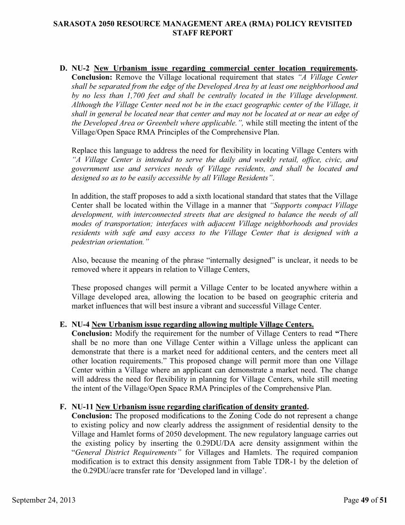
SARASOTA 2050 RESOURCE MANAGEMENT AREA (RMA) POLICY REVISITED
STAFF REPORT
September 24, 2013 Page 49 of 51
D. NU-2 New Urbanism issue regarding commercial center location requirements.
Conclusion: Remove the Village locational requirement that states “A Village Center
shall be separated from the edge of the Developed Area by at least one neighborhood and
by no less than 1,700 feet and shall be centrally located in the Village development.
Although the Village Center need not be in the exact geographic center of the Village, it
shall in general be located near that center and may not be located at or near an edge of
the Developed Area or Greenbelt where applicable.”, while still meeting the intent of the
Village/Open Space RMA Principles of the Comprehensive Plan.
Replace this language to address the need for flexibility in locating Village Centers with
“A Village Center is intended to serve the daily and weekly retail, office, civic, and
government use and services needs of Village residents, and shall be located and
designed so as to be easily accessible by all Village Residents”.
In addition, the staff proposes to add a sixth locational standard that states that the Village
Center shall be located within the Village in a manner that “Supports compact Village
development, with interconnected streets that are designed to balance the needs of all
modes of transportation; interfaces with adjacent Village neighborhoods and provides
residents with safe and easy access to the Village Center that is designed with a
pedestrian orientation.”
Also, because the meaning of the phrase “internally designed” is unclear, it needs to be
removed where it appears in relation to Village Centers,
These proposed changes will permit a Village Center to be located anywhere within a
Village developed area, allowing the location to be based on geographic criteria and
market influences that will best insure a vibrant and successful Village Center.
E. NU-4 New Urbanism issue regarding allowing multiple Village Centers.
Conclusion: Modify the requirement for the number of Village Centers to read “There
shall be no more than one Village Center within a Village unless the applicant can
demonstrate that there is a market need for additional centers, and the centers meet all
other location requirements.” This proposed change will permit more than one Village
Center within a Village where an applicant can demonstrate a market need. The change
will address the need for flexibility in planning for Village Centers, while still meeting
the intent of the Village/Open Space RMA Principles of the Comprehensive Plan.
F. NU-11 New Urbanism issue regarding clarification of density granted.
Conclusion: The proposed modifications to the Zoning Code do not represent a change
to existing policy and now clearly address the assignment of residential density to the
Village and Hamlet forms of 2050 development. The new regulatory language carries out
the existing policy by inserting the 0.29DU/DA acre density assignment within the
“General District Requirements” for Villages and Hamlets. The required companion
modification is to extract this density assignment from Table TDR-1 by the deletion of
the 0.29DU/acre transfer rate for ‘Developed land in village’.
SARASOTA 2050 RESOURCE MANAGEMENT AREA (RMA) POLICY REVISITED
STAFF REPORT
September 24, 2013 Page 50 of 51
G. NU-13 New Urbanism issue regarding clarification of how dwelling units are
derived.
Conclusion: The proposed modifications to the Zoning Code do not represent a change
to existing policy, and actually bring the Zoning Code into alignment with existing
policy. It now also will include an explanation for how the transfer rates within Table
TDR-1 were derived and how they are applied within 2050 projects. These proposed
modifications are also supported by the regulatory language modifications proposed
pursuant to issue NU-11, which deletes the 0.29DU/acre transfer rate for ‘Developed land
in village’ from Table TDR-1. Table TDR-1, as proposed to be modified, would now
only provide for the actual transferring of TDR units, rather than a mixing of concepts as
currently exists within the table.

APPENDIX ‘A’ – BIBLIOGRAPHY
September 24, 2013 Page 51 of 51
Bibliography presented in the order of appearance within staff report:
1 “Charter of the New Urbanism”. Congress for the New Urbanism, 2001. Web. 06 Aug. 2013.
<http://www.cnu.org/charter>.
2 Corrigan, Mary Beth, et al. “Ten Principles for Smart Growth on the Suburban Fringe”.
Washington D.C.: ULI-the Urban Land Institute, 2004.
3 “Codifying New Urbanism”. American Planning Association, Planning Advisory Service
Report No. 526, May 2004.
4 Ellis, Cliff. “The New Urbanism: Critiques and Rebuttals”. Journal of Urban Design, Vol. 7,
No. 3, 261-292, 2002.
5 Duggal, Melina. “Market Pitfalls of Form-Based or Smart Codes”. RCLCO The Advisory,
Feb. 26, 2013.
6 “The Principles of Smart Development”. American Planning Association, Planning Advisory
Service Report No. 470, Sept. 1998.
7 “Rental Resurgence Marked by Single-Family Expansion and Diverging Affordability Trends
for Owners and Renters”. Fannie Mae Planning & Economic Strategic Research Group, Fannie
Mae Housing Insights, Vol. 2, Issue 5, Nov. 15, 2012.
8 "LEED 2009 for Neighborhood Development (LEED-ND)." Congress for the New Urbanism.
U.S. Green Building Council, 2009. Web. 12 Aug. 2013.
9 Herndon, Joshua D. "Mixed-Use Development in Theory and Practice: Learning from Atlanta's
Mixed Experiences." Georgia Institute of Technology, 5 May 2011. Web. 7 Aug. 2013.
10
“Development Hurdles in Mixed Use Projects.” Cole Shotz, Leading Mid-Atlantic Law Firm:
Construction Related Bankruptcies. Cole Shotz Docket, Winter 2008. Web. 13 Aug. 2013.