satellite-based thunderstorm tracking, monitoring and...
TRANSCRIPT

Standardfoliensatz >01.03.2007
Satellite-based thunderstorm tracking, monitoring and nowcasting
over South Africa
Caroline Forster1, Estelle de Coning2, Sebastian Diebel1, Tobias Zinner3
EUMETSAT Meteorological Satellite Conference Cordoba, Spain, 20 – 24 September 2010
1 DLR Institute of Atmospheric Physics, Oberpfaffenhofen, Germany
2 South African Weather Service
3 Meteorological Institute, University of Munich, Germany
Folie 2
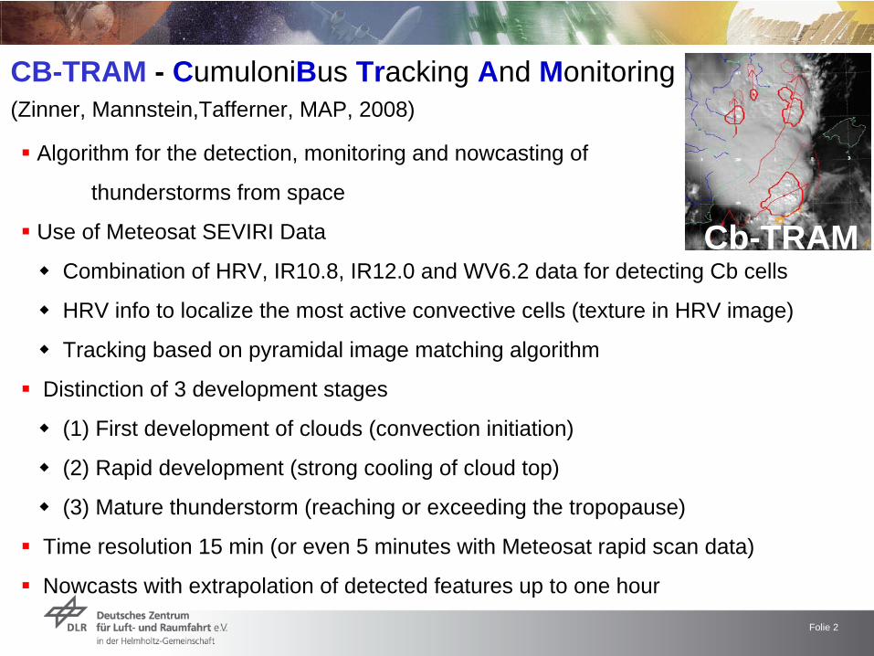
CB-TRAM - CumuloniBus Tracking And Monitoring (Zinner, Mannstein,Tafferner, MAP, 2008)
Algorithm for the detection, monitoring and nowcasting of
thunderstorms from space
Use of Meteosat SEVIRI Data
Combination of HRV, IR10.8, IR12.0 and WV6.2 data for detecting Cb cells
HRV info to localize the most active convective cells (texture in HRV image)
Tracking based on pyramidal image matching algorithm
Distinction of 3 development stages
(1) First development of clouds (convection initiation)
(2) Rapid development (strong cooling of cloud top)
(3) Mature thunderstorm (reaching or exceeding the tropopause)
Time resolution 15 min (or even 5 minutes with Meteosat rapid scan data)
Nowcasts with extrapolation of detected features up to one hour
Cb-TRAM
Folie 3
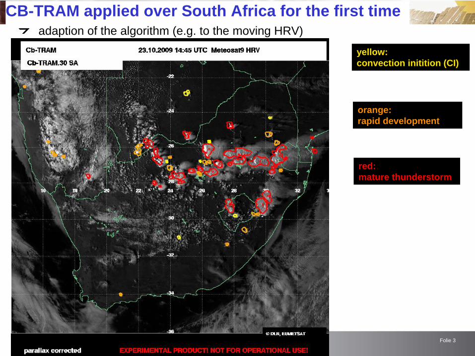
CB-TRAM applied over South Africa for the first timeadaption of the algorithm (e.g. to the moving HRV)
yellow: convection initition (CI)
orange: rapid development
red: mature thunderstorm
Folie 4
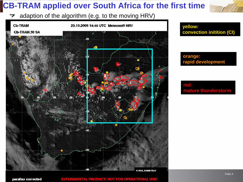
CB-TRAM applied over South Africa for the first timeadaption of the algorithm (e.g. to the moving HRV)
yellow: convection initition (CI)
orange: rapid development
red: mature thunderstorm
Folie 5
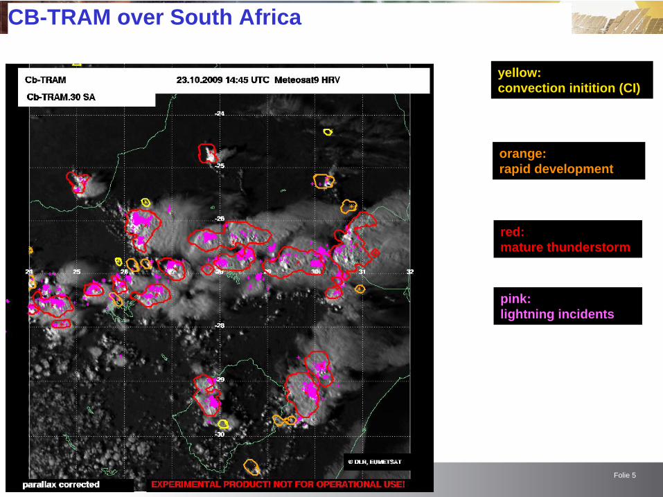
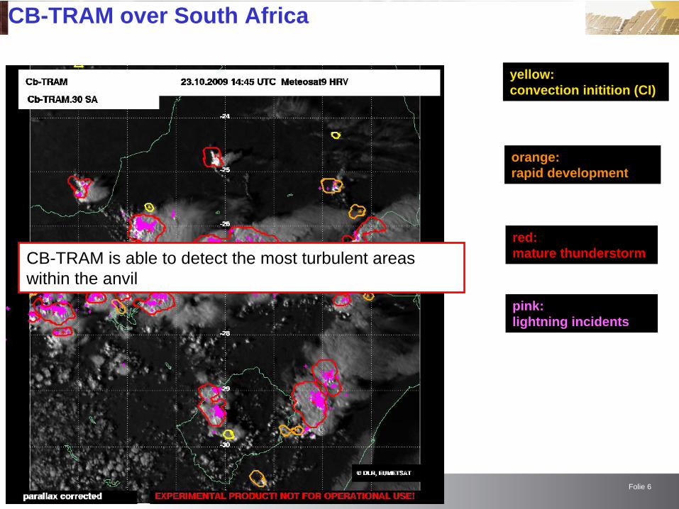
CB-TRAM over South Africa
yellow: convection initition (CI)
orange: rapid development
red: mature thunderstorm
pink: lightning incidents
Folie 6
CB-TRAM over South Africa
yellow: convection initition (CI)
orange: rapid development
red: mature thunderstorm
pink: lightning incidents
CB-TRAM is able to detect the most turbulent areas within the anvil

Folie 7
CB-TRAM applied over South Africa
yellow: convection initition
orange: rapid development
red: mature thunderstorm
pink: lightning incidents(0-10 min after image time)
Folie 8
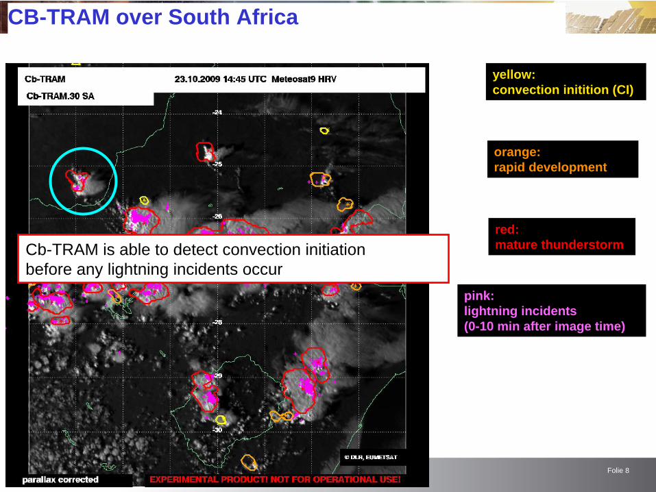
CB-TRAM over South Africa
yellow: convection initition (CI)
orange: rapid development
red: mature thunderstorm
pink: lightning incidents
Cb-TRAM is able to detect convection initiationbefore any lightning incidents occur
pink: lightning incidents(0-10 min after image time)

Folie 10
CB-TRAM over South Africa
yellow: convection initition (CI)
orange: rapid development
red: mature thunderstorm
grey: 15, 30, 45, 60 Min. nowcast
pink: lightning incidents
pink: lightning incidents(0-10 min after image time)

Folie 11
CB-TRAM over South Africa
yellow: convection initition (CI)
orange: rapid development
red: mature thunderstorm
grey: 15, 30, 45, 60 Min. nowcast
pink: lightning incidents
Cb-TRAM is able to nowcast the development and movement of the Cb cells up to one hour
pink: lightning incidents(0-10 min after image time)

Folie 12
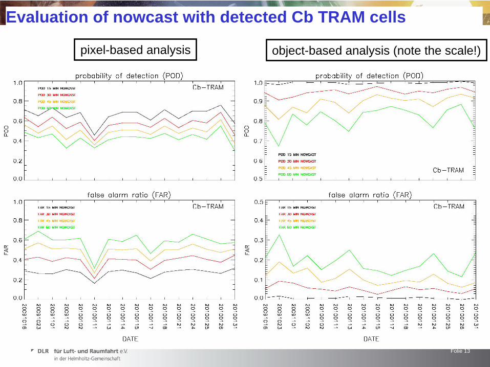
Evaluation of nowcast with detected Cb TRAM cells
pixel-based analysis (requires exact match of objects)hit = nowcast matches observation at a pixelmiss = observation which is not nowcast at a pixelfalse alarm = nowcast which is not observed at a pixel
object-based analysis (does not require exact match of objects)hit = nowcast object overlaps observed objectmiss = observed object which is not nowcastfalse alarm = nowcast object which is not observed
black: observed object at time tgrey: nowcast object for time tblue: missesred: false alarmsgreen :hits
+ + + + + + + + + + + + + + + + + + + + + + + + + + + + + + + + + + + + + + + + + + + + + + + + + + + + + + + +
POD = hits / (hits + misses)FAR = false alarms / (hits + false alarms)
Folie 13
Evaluation of nowcast with detected Cb TRAM cells
pixel-based analysis object-based analysis (note the scale!)

Folie 14
Simple evaluation of detected/nowcast Cb TRAM cells with lightning data
hit = lightning incident inside of Cb-TRAM cellmiss = lightning incident outside of Cb-TRAM cellfalse alarm = Cb-TRAM cell without lightning
black contour: observed Cb object at time tgreen stars: lightning incidents (hits)blue stars: lighning incidents (misses)red object: object without lightning (false alarm)
POD = hits / (hits + misses)FAR = false alarms / (hits + false alarms)

Folie 15
Simple evaluation of detected/nowcast Cb TRAM cells with lightning data
note that cells indicatingCI and do (correctly) not (yet)contain lightning are also included in this analysis and are counted as false alarms
also single lightning eventsthat do not belong to lightningclusters and are typicallynot related to Cb-TRAM cellsare included and countedas misses
Folie 16
Summary and conclusionsCb-TRAM
has successfully been applied over South Africa for the first time
detects the most active regions within a thunderstorm
is able to detect convection initiation before any lightning incident occurs
is able to nowcast the movement and development of thunderstorms up to one hour
The evaluation of nowcast with detected Cb-TRAM cells shows that
pixel-based POD = 75%, FAR = 25% (15 min nowcast)
object-based POD = 98%, FAR = 3% (15 min nowcast)
POD decreases with increasing lead time, while FAR increases
the nowcasting for lead times greater 30 minutes has to be improved
The evaluation of Cb-TRAM detections and nowcasts with lightning data shows that
Cb-TRAM agrees generally well with lightning data (POD = 80%, FAR = 5%)
Cb-TRAM is a useful tool for the (early) detection, trackingand nowcasting of thunderstorms over South Africa