satellite soil moisture remote sensing and data ... · 4/20/2007 · data assimilation: brief...
TRANSCRIPT

Slide 1/68
Satellite Soil Moisture Remote Sensing and Data Assimilation:
Brief History & Current Status
Satellite Soil Moisture Remote Sensing and Data Assimilation:
Brief History & Current Status
X. ZhanNOAA-NESDIS Center for Satellite Applications and Research
W. Crow, T. J. Jackson, M. Cosh, USDA-ARS Hydrology and Remote Sensing LabS. Kumar, C. Peters-Lidard & P. O’Neill, NASA-GSFC Hydrological Sciences Branch
P. Houser, GMU/Center for Research on Energy and Water (CREW)J. Walker, University of Melbourne, Australia
Jesse Meng, K. Mitchell, NOAA-NCEP Environmental Modeling Center

Slide 2/68NOAA-NESDIS-STAR, Science Forum, April 20, 2007
1. SM Data & Importance
OUTLINE
2. SM Observation Techniques
3. MW Soil Moisture Retrievals
4. Soil Moisture Data Assimilation
5. SM Data Research Plan
Slide 2/68

Slide 3/681. Soil Moisture Data & Importance
Soil Moisture Data & their ValuesSoil Moisture Data & their Values
SM = Water held between soil particles:Volumetric Soil Moisture (VSM) = [m3 H2O]/[m3 Soil], [%]; [-]Gravimetric Soil Moisture (GSM) = [kg H2O]/[kg Solid Soil], [g/g]Soil Wetness (SW) = VSM/Porosity
Soil moisture directly impacts agricultural productivity, military mobility, runoff potential/flood control/reservoir management, and for NOAA

Slide 4/68
24-Hours Ahead Atmospheric Model Forecasts
Observed Rainfall0000Z to 0400Z 13/7/96(Chen et al., NCAR)
Buffalo CreekBasin
"The strong motivation for this land data assimilation and land-monitoring space missions such as Hydros is that the land states of soil moisture, soil ice, snowpack, and vegetation exert a strong control on ...the heating and moistening of the lower atmosphere…forecast of tomorrow's heat index, precipitation, and severe thunderstorm likelihood."
Louis Uccellini, NCEP
“The experience of the last ten years at ECMWF has shown the importance of soil moisture...Soil moisture is a major player on the quality of weather parameters such as precipitation, screen-level temperature and humidity and low-level clouds."
Anthony Hollingworth, ECMWF
Soil Moisture Data Will Improve Numerical Weather Prediction (NWP) Over the Continents by Accurately Initializing Land Surface States
With Realistic Soil Moisture
Without Realistic Soil Moisture
Observed Rainfall from intense storm in Colorado: Model forecasts with and w/o soil moisture:
Actual storm event is forecasted accurately only if soil moisture information is available.
Soil Moisture Impacts on Weather Forecasting (1)Soil Moisture Impacts on Weather Forecasting (1)
1. Soil Moisture Data & Importance
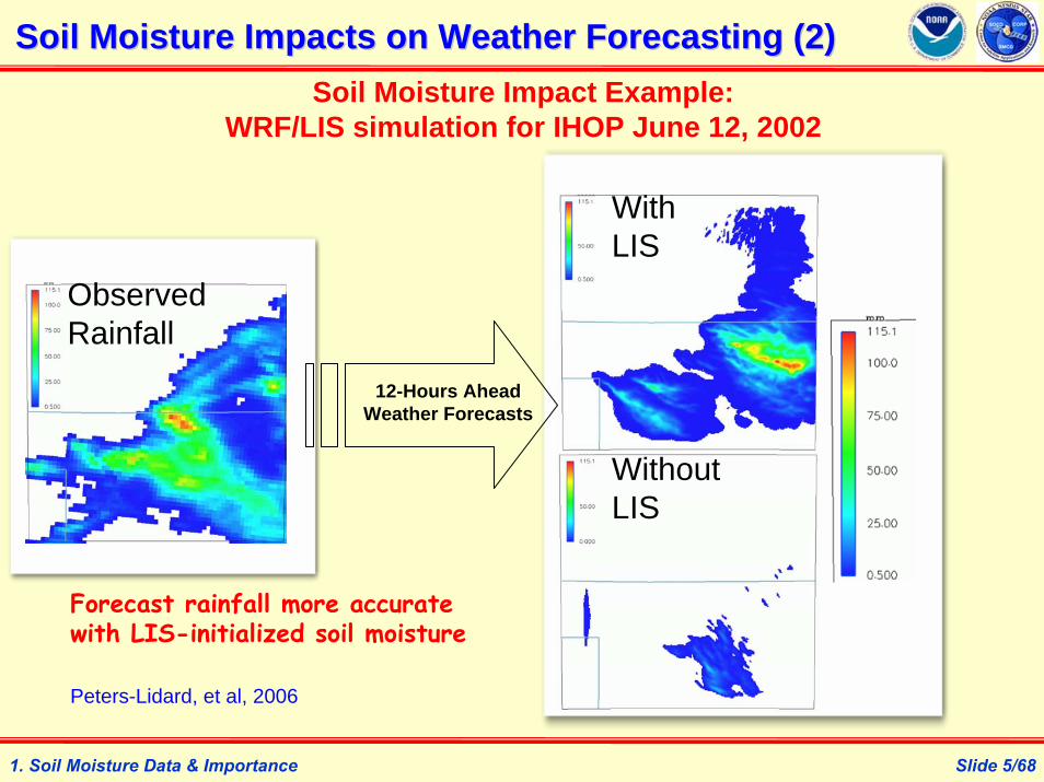
Slide 5/68
12-Hours Ahead Weather Forecasts
Soil Moisture Impact Example: WRF/LIS simulation for IHOP June 12, 2002
WithLIS
WithoutLIS
ObservedRainfall
Forecast rainfall more accurate with LIS-initialized soil moisture
Soil Moisture Impacts on Weather Forecasting (2)Soil Moisture Impacts on Weather Forecasting (2)
Peters-Lidard, et al, 2006
1. Soil Moisture Data & Importance

Slide 6/68
Model driven by SSTsModel driven by soil moisture and SSTs
Observations
-5 0 +5
Rainfall Difference
[mm/day]
Summer 1993 Rainfall Minus Summer 1988 Rainfall
Model driven by SSTsModel driven by soil moisture and SSTs
Observations
-5 0 +5
Rainfall Difference
[mm/day]
Summer 1993 Rainfall Minus Summer 1988 Rainfall
Schubert et al. (2002)Koster et al. (2004), Science, 305, 1138-1140.
Soil Moisture Impacts on Seasonal PredictabilitySoil Moisture Impacts on Seasonal Predictability
1. Soil Moisture Data & Importance

Slide 7/68
Current NWS Operational 30 km Flash Flood Guidance (FFG) is Based on Model Surface Soil Moisture Deficit
Current NOAA and National Drought Mitigation Center (NDMC) Operational Drought Index is also based on ModeledSoil Moisture Data.
Soil moisture Observational data will replace model or proxy SM
Soil Moisture Data for Flood & Drought Monitoring Soil Moisture Data for Flood & Drought Monitoring
1. Soil Moisture Data & Importance

Slide 8/68
Soil Moisture Observation TechniquesSoil Moisture Observation Techniques
2. Soil Moisture Observation Techniques
Soil Sampling Point Data CollectionGSM = (Wwet – Wdry)/WdryBD (Bulk Density) = Wdry/Volume VSM = GSM * BD
Time Domain Reflectometer (TDR): Point Data CollectionTheta probe, etc
Microwave Radiometer/Radar: Global/Regional MappingGround-based: TMMR, GBMR, SLMR, etcAir-borne: ESTAR, PBMR, PSR, etcSatellite-borne: Skylab, SMMR, SSM/I, TMI, AMSR-E, WindSat, ESCAT, ASCAT, SMOS, Aquarius, and GPM? Hydros? MIS?

Slide 9/68
MW Soil Moisture Remote Sensing Science (1)MW Soil Moisture Remote Sensing Science (1)
2. Soil Moisture Observation Techniques
Scientific Basis:Dielectric constants: εwater = ~ 80, εdry_soil < 4, εwet_soil = 4 – 80;Fresnel equation: reflectivity <-> εwet_soil σ = f(SM, etc, etc);emissivity = 1 – reflectivity, TB = g(SM, etc).
Brief Research History (Passive Radiometry): 1930s-1950s: MW “upward” radiometer used to measure EM energy of extraterrestrial origin.Straiton et al (1958): 1st radiometer pointing “downward” for terrestrial observations.Blinn & Quade (1973), Schmugge et al (1974, 1977), England (1975), Ulaby et al (1975), Njoku & Kong (1977), Eagleman & Lin (1976), Schmugge (1978): 1st radiometers for soil moisture remote sensing.Choudhury et al (1979), Schmugge (1980), Wang & Schmugge (1980), Dobson & Ulaby (1981), Jackson et al (1982), Mo et al (1982), Shutko et al (1982), Dobson et al (1984, 1985), Wang (1985): 1st studies accounting impacts of roughness, soil texture, vegetation canopy, skin temperature and SM itself on the SM-TB relationships.Jackson (1993), Jackson (1997), Njoku & Li (1999), Owe et al (2001), and others: development, refinement, and validation of regional or global soil moisture retrieval algorithms.

Slide 10/68
Microwave Sensitivity By Wavelength and Vegetation Density
0.0
1.0
2.0
3.0
4.0
0 5 10 15 20 25Wavelength (cm)
Sens
itivi
ty (
Del
ta T
B /
Del
ta
Vol
. SM
)
BARE
VEGETATIONWATER CONTENT (kg/m2)
1
2
4
0
SSM/I AMSR/CMIS HYDROS / SMOSTMI19 GHz 10.7 GHz 6.9 GHz 1.4 GHz
MW Soil Moisture Remote Sensing Science (2)MW Soil Moisture Remote Sensing Science (2)
2. Soil Moisture Observation Techniques
Slide 11/68
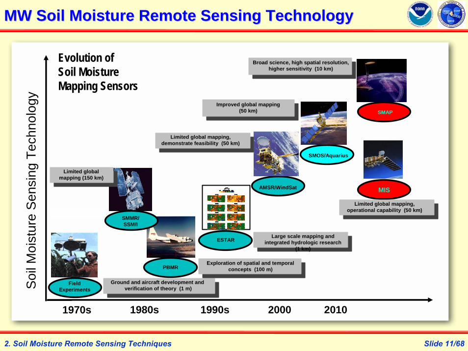
MW Soil Moisture Remote Sensing TechnologyMW Soil Moisture Remote Sensing Technology
2. Soil Moisture Remote Sensing Techniques
1970s 1980s 1990s 2000
Ground and aircraft development andverification of theory (1 m)
Limited global mapping, demonstrate feasibility (50 km)
Large scale mapping and integrated hydrologic research
(1 km)
Exploration of spatial and temporal concepts (100 m)
FieldExperiments
SMOS/Aquarius
AMSR/WindSat
ESTAR
PBMR
Evolution of Soil Moisture Mapping Sensors
Soi
l Moi
stur
e S
ensi
ng T
echn
olog
y
SMAPImproved global mapping
(50 km)
Broad science, high spatial resolution, higher sensitivity (10 km)
2010
SMMR/ SSM/I
Limited global mapping (150 km)
MIS
Limited global mapping, operational capability (50 km)

Slide 12/68
The Tropical Rainfall Measurement Mission (TRMM) Microwave Imager (TMI) observes the 35N-35S latitude zone at five separate frequencies since 1997: 10.7, 19.4, 21.3, 37, 85.5 GHz. Bindlish & Jackson (2003) has created a global tropical area soil moisture data product.
Microwave Soil Moisture Sensors Details (1)Microwave Soil Moisture Sensors Details (1)
2. Soil Moisture Remote Sensing Techniques
The Special Sensor Microwave Imager (SSM/I) is a passive microwave radiometer flown aboard Defense Meteorological Satellite Program (DMSP) satellites since 1987: DMSP F-8, 10, 11,12,13,14,15. SSMI/S on F-16 follows. A Global Soil Wetness Index product has been created by Bob Kuligowski.
The Scanning Multichannel Microwave Radiometer (SMMR): launched with Nimbus-7 in 1978 and stopped in 1987; was measuring TBs at 6.63, 10.69, 18.0, 21.0 and 37.0 GHz frequencies. Own et al (2001) created a SM product.

Slide 13/68
AMSR-E is Japan’s Advanced Microwave Scanning Radiometer for NASA’s Earth Observing System. It’s onboard the Aqua satellite of EOS that was successfully launched in May 2002. A global Soil moisture has been created by Njoku et al (2003) since 2002.
Microwave Soil Moisture Sensors Details (2)Microwave Soil Moisture Sensors Details (2)
WindSat/Coriolis is another MW radiometer successfully launched by Naval Research Lab (NRL) primarily for ocean wind and SST in Jan. 2003. It has C- and X-band observations similar to AMSR-E and can be used to derive global soil moisture products.
2. Soil Moisture Remote Sensing Techniques

Slide 14/68
ESCAT-1/2 are C-band (5.3GHz) scatterometer flown onboard ERS-1 (1991-1996) and ERS-2 (1995-present). ASCAT is the advanced scatterometer flown on MetOP-A since Oct. 2006. Intensive researches have been done at Vienna University of Technology in Austria to derive a global soil moisture data set from these scatterometers’ observations (Wagner et al, 2003).
Microwave Soil Moisture Sensors Details (3)Microwave Soil Moisture Sensors Details (3)
2. Soil Moisture Remote Sensing Techniques
The synthetic aperture radars (SAR) on ERS-1/2 (1991-present) and the advanced SAR (ASAR) onboard ENVISAT (2002-present) are providing high spatial resolution backscatter observations which can also be used to derive soil moisture. However, further research is needed to derive operational soil moisture data products from the radar observations.

Slide 15/68
Microwave Soil Moisture Sensors Details (4)Microwave Soil Moisture Sensors Details (4)
2. Soil Moisture Remote Sensing Techniques
European Space Agency (ESA) has planned a Soil Moisture and Ocean Salinity (SMOS) mission to specifically observation global soil moisture using L-band MW radiometry. The satellite will be launched in 2008.
United States also planned the Conical Scanning Microwave Imager/ Sounder (CMIS) for NPOESS, and cancelled the instrument in 2006.
NASA’s decadal survey on Earth Science and Applications from Space listed a soil moisture active-passive mission (SMAP) as one of four missions recommended to NASA for year 2010-2013 time frame.
United States planned a HydrosphericStates (Hydros) mission to specifically observation global soil moisture using both L-band MW radiometer and radar, but cancelled the mission in later 2005.

Slide 16/68
Microwave Soil Moisture RetrievalsMicrowave Soil Moisture Retrievals
3. MW Soil Moisture Retrievals
Evaluation of NASAEvaluation of NASA’’s Current AMSRs Current AMSR--E Soil E Soil Moisture Data ProductMoisture Data Product
An Alternative AMSR-E Soil Moisture Data Product from NOAA-USDA
Retrieving High Resolution Soil Moisture From Hydros

Slide 17/68
NASA’s newest satellite observational data product of global land surface soil moisture.
Acquired (almost) continuously since June 18, 2002.
Spatial resample resolution is 25km by 25km and available for most land areas once every 2-3 days.
Generated from constrained inversion method using AMSR-E 10.7 and 18.7GHz channels with footprint sizes about 21km to 38km.
NASANASA’’s AMSRs AMSR--E Soil Moisture Data ProductE Soil Moisture Data Product
3. MW Soil Moisture Retrievals

Slide 18/68
NASA GSFC and partners have developed the North America Land Data Assimilation System (NLDAS) and Global Land Data Assimilation System (GLDAS) that can output soil moisture simulations of various land surface models (e.g. Mosaic, Noah, CLM, …);
NLDAS Mosaic soil moisture data for the years since 1996 have been available at the website http://ldas.gsfc.nasa.gov
Through the enhanced version of LDAS software system (LIS), LDAS LSMs can be run at many spatial resolution (e.g., 0.25 lat/long matching AMSR-E soil moisture data product)
The NLDAS atmospheric forcing data sets (Cosgrove et al, 2003) are used to simulate soil moisture with Mosaic and Noah LSMs for this study.
3. MW Soil Moisture Retrievals
Land Surface Model Simulations from LDASLand Surface Model Simulations from LDAS

Slide 19/68
Soil Moisture Experiments (SMEX)Soil Moisture Experiments (SMEX)
Name Latit. Long. #site #day St Day End Day
smex02ia 41.50N 94.00W 48 18 6/25 7/12
smex03ga 30.75N 84.00W 49 10 6/23 7/02
smex03on 35.75N 98.25W 36 16 7/02 7/17
smex03os 34.25N 98.50W 52 16 7/02 7/17
smex04az 31.00N 110.5W 40 24 8/03 8/26
3. MW Soil Moisture Retrievals

Slide 20/68
Resample AMSR-E Level2 soil moisture retrievals to 0.25 degree lat/long grids matching the LDAS 0.25 degree grids;
Spin up Mosaic and Noah model simulations within NLDAS domain from 1997 to 2002;
Run NLDAS-Mosaic/Noah LSMs from 2002 to 2004 to cover the time periods of AMSR-E and SMEXes data time;
Average the regional sampling sites of SMEXes within each 0.25 degree lat/long grids of NLDAS simulations and AMSR-E data.
3. MW Soil Moisture Retrievals
Comparison ProcedureComparison Procedure

Slide 21/68
AMSR-E
Mosaic LSM
Noah LSM
SMEX
3. MW Soil Moisture Retrievals
Daily (18Z) Soil Moisture VariationsDaily (18Z) Soil Moisture Variations

Slide 22/68
AMSR-E
Mosaic LSM
Noah LSM
SMEX
3. MW Soil Moisture Retrievals
Daily (18Z) Soil Moisture VariationsDaily (18Z) Soil Moisture Variations

Slide 23/68
AMSR-E
Mosaic LSM
Noah LSM
SMEX
3. MW Soil Moisture Retrievals
Daily (18Z) Soil Moisture VariationsDaily (18Z) Soil Moisture Variations
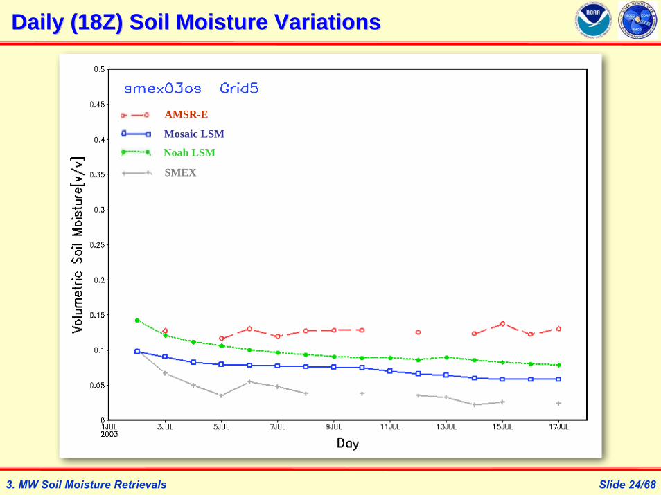
Slide 24/68
AMSR-E
Mosaic LSM
Noah LSM
SMEX
3. MW Soil Moisture Retrievals
Daily (18Z) Soil Moisture VariationsDaily (18Z) Soil Moisture Variations

Slide 25/68
AMSR-E
Mosaic LSM
Noah LSM
SMEX
3. MW Soil Moisture Retrievals
Daily (18Z) Soil Moisture VariationsDaily (18Z) Soil Moisture Variations

Slide 26/68
SM Spatial Pattern ComparisonSM Spatial Pattern Comparison
AMSR-E Mosaic Noah SMEX
04AZ
03OS
03GA
02IASM Data
Characteristics:
AMSR-E: 1.Global MW obs;2.Good time cover; 3.Too flat?
Mosaic & Noah:1.Good space
cover;2.Too low/high?
Field Obs:1.Too sparse?2.Too tedious?
3. MW Soil Moisture Retrievals

Slide 27/68
Purpose: LSM simulations can have full time and space coverage, but accuracy is uncertain; AMSR-E retrievals are patchy, biased and variations damped. Data assimilation can combine them, but their scales need to be matched for DA methods such as EnKF;
The cumulative distribution function matching method used in Reichle & Koster (2004) can scale the AMSR-E retrievals to the simulations of LSMs to be used for assimilation;
How will the scaled AMSR-E data be compared with the model simulations?
3. MW Soil Moisture Retrievals
CDF Matching of AMSRCDF Matching of AMSR--E SM to LSM SimulationsE SM to LSM Simulations
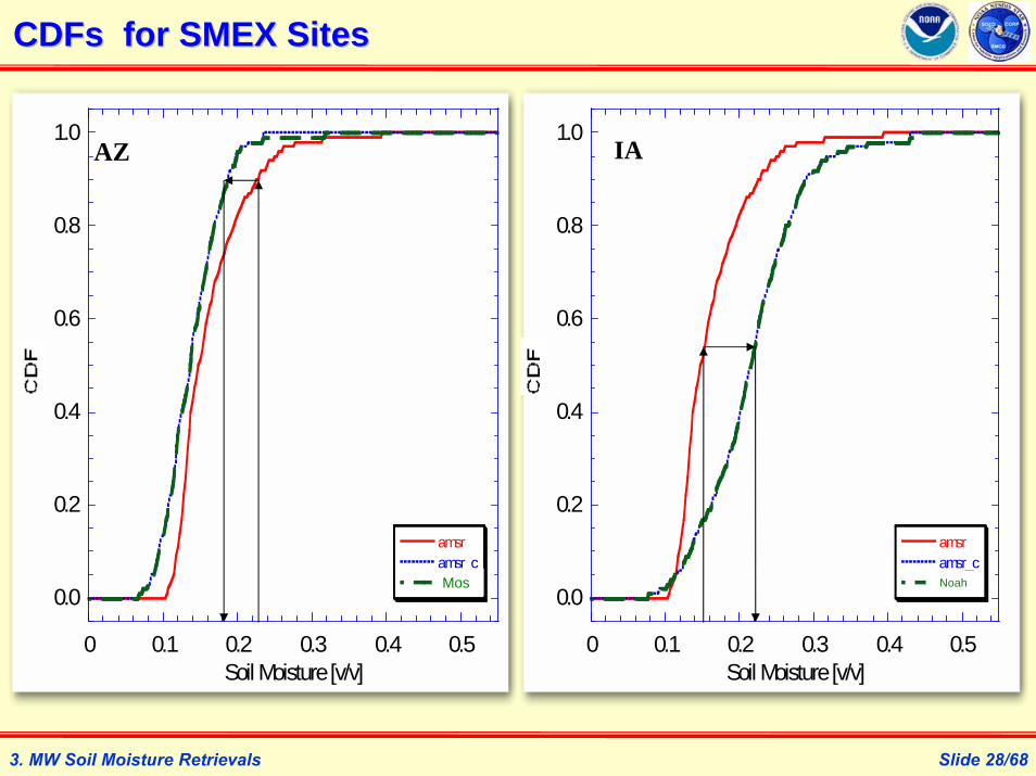
Slide 28/68
CDFsCDFs for SMEX Sitesfor SMEX Sites
0.0
0.2
0.4
0.6
0.8
1.0
0 0.1 0.2 0.3 0.4 0.5
amsramsr_cmodel
Soil Moisture [v/v]
0.0
0.2
0.4
0.6
0.8
1.0
0 0.1 0.2 0.3 0.4 0.5
amsramsr_cmodel
Soil Moisture [v/v]
Mos Noah
AZ IA
3. MW Soil Moisture Retrievals

Slide 29/68
AMSR-E
Mosaic LSM
Mosaic-scaled AMSR-E
SMEX
Scaled AMSRScaled AMSR--E SM E SM vsvs Model SimulationsModel Simulations
3. MW Soil Moisture Retrievals

Slide 30/68
AMSR-E
Noah LSM
Noah-scaled AMSR-E
SMEX
3. MW Soil Moisture Retrievals
Scaled AMSRScaled AMSR--E SM E SM vsvs Model SimulationsModel Simulations

Slide 31/683. MW Soil Moisture Retrievals
UNHUNH’’ss Comparison Results (Comparison Results (ChoiChoi & Jacobs, 2006)& Jacobs, 2006)

Slide 32/683. MW Soil Moisture Retrievals
PUPU’’ss Comparison Results (McCabe et al, 2004)Comparison Results (McCabe et al, 2004)

Slide 33/683. MW Soil Moisture Retrievals
PUPU’’ss Comparison Results (McCabe et al, 2004)Comparison Results (McCabe et al, 2004)

Slide 34/68
AMSR-E soil moisture retrievals, Mosaic and Noah LSM simulations are compared with SMEXes field measurements at the 0.25 degree grid scale;
AMSR-E soil moisture retrievals mostly followed the soil moisture dynamic trends of either model simulations or field measurements;
But AMSR-E soil moisture retrievals are generally too wet for dry surfaces and too dry for wet surfaces;
The current utilization of AMSR-E soil moisture retrievals is to assimilate them into a LSM after matching their CDFs;
Further work is needed to improve the AMSR-E retrievals.
3. MW Soil Moisture Retrievals
Summary on NASASummary on NASA’’s AMSRs AMSR--E SM Product EvaluationE SM Product Evaluation

Slide 35/68
Microwave Soil Moisture RetrievalsMicrowave Soil Moisture Retrievals
3. MW Soil Moisture Retrievals
Evaluation of NASA’s Current AMSR-E Soil Moisture Data Product
An Alternative AMSRAn Alternative AMSR--E Soil Moisture Data E Soil Moisture Data Product from NOAAProduct from NOAA--USDAUSDA
Retrieving High Resolution Soil Moisture From Hydros
Slide 36/68
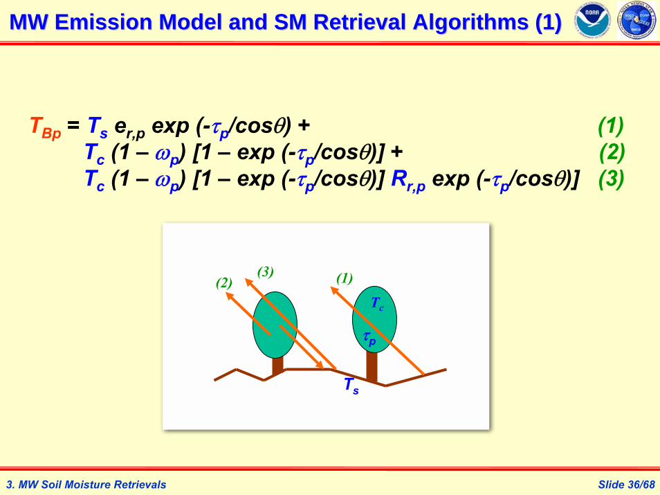
TBp = Ts er,p exp (-τp/cosθ) + (1)Tc (1 – ωp) [1 – exp (-τp/cosθ)] + (2)Tc (1 – ωp) [1 – exp (-τp/cosθ)] Rr,p exp (-τp/cosθ)] (3)
MW Emission Model and SM Retrieval Algorithms (1)MW Emission Model and SM Retrieval Algorithms (1)
3. MW Soil Moisture Retrievals
(1)(3)(2)
Tc
Ts
τp

Slide 37/68
TB,icmp = Tskin {er,p exp (-τi/cosθ) +
(1 – ω) [1 – exp (-τi/cosθ)][1 + Rr,i exp (-τi/cosθ)]}
τi = b *VWCRr,i = Rs exp(h cos2θ)Rs = f(ε) -- Fresnel Equationε = g(SM) -- Mixing model
TB,iobs =TB06h , TB06v , TB10h , TB10v , TB18h , TB18v
3. MW Soil Moisture Retrievals
MW Emission Model and SM Retrieval Algorithms (2)MW Emission Model and SM Retrieval Algorithms (2)
}min{2
6
1
,,2 ∑=
⎟⎟⎠
⎞⎜⎜⎝
⎛ −=
i i
cmpiB
obsiB TT
σχ
NASA’s AMSR-E SM Baseline Retrieval Algorithm:

Slide 38/68
TB10h = Ts [1 –Rr exp (-2τ /cosθ)]
Rr = Rs exp(h cos2θ)Rs = f(ε) -- Fresnel Equationε = g(SM) -- Mixing model
Ts = reg1(TB37v) or TsLSM
τ = b * VWCVWC = reg2(NDVI)
3. MW Soil Moisture Retrievals
MW Emission Model and SM Retrieval Algorithms (3)MW Emission Model and SM Retrieval Algorithms (3)
An Alternative AMSR-E SM Retrieval Algorithm –Single Channel Retrieval (SCR):
Slide 39/68
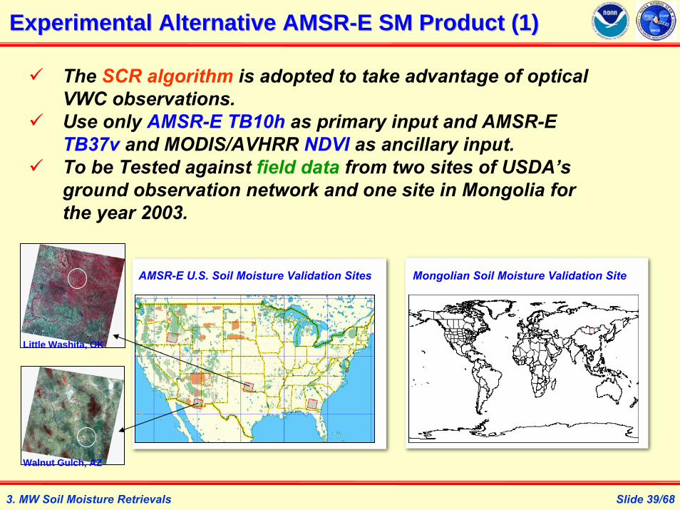
Experimental Alternative AMSRExperimental Alternative AMSR--E SM Product (1)E SM Product (1)
3. MW Soil Moisture Retrievals
The SCR algorithm is adopted to take advantage of optical VWC observations.Use only AMSR-E TB10h as primary input and AMSR-E TB37v and MODIS/AVHRR NDVI as ancillary input.To be Tested against field data from two sites of USDA’s ground observation network and one site in Mongolia for the year 2003.
Little Washita, OK
Walnut Gulch, AZ
AMSR-E U.S. Soil Moisture Validation Sites Mongolian Soil Moisture Validation Site

Slide 40/683. MW Soil Moisture Retrievals
Experimental Alternative AMSRExperimental Alternative AMSR--E SM Product (2)E SM Product (2)
Spatial Map

Slide 41/683. MW Soil Moisture Retrievals
Experimental Alternative AMSRExperimental Alternative AMSR--E SM Product (3)E SM Product (3)

Slide 42/683. MW Soil Moisture Retrievals
Experimental Alternative AMSRExperimental Alternative AMSR--E SM Product (4)E SM Product (4)

Slide 43/683. MW Soil Moisture Retrievals
Experimental Alternative AMSRExperimental Alternative AMSR--E SM Product (5)E SM Product (5)

Slide 44/683. MW Soil Moisture Retrievals
Experimental Alternative AMSRExperimental Alternative AMSR--E SM Product (6)E SM Product (6)
Scatter Plot

Slide 45/683. MW Soil Moisture Retrievals
Experimental Alternative AMSRExperimental Alternative AMSR--E SM Product (7)E SM Product (7)
Scatter Plot

Slide 46/683. MW Soil Moisture Retrievals
Experimental Alternative AMSRExperimental Alternative AMSR--E SM Product (8)E SM Product (8)
Scatter Plot

Slide 47/683. MW Soil Moisture Retrievals
Experimental Alternative AMSRExperimental Alternative AMSR--E SM Product (9)E SM Product (9)
Site Alg RMSE Bias R Slope
NASA 3.1% 3.2% 0.626 0.201
SCR 3.0% -0.7% 0.564 0.379
NASA 4.6% 2.4% 0.508 0.255
SCR 3.6% -0.7% 0.756 0.601
NASA 7.7% -3.8% 0.089 0.025
SCR 6.4% -4.1% 0.583 0.460MG01
LW01
WG01
Error Statistics

Slide 48/68
Microwave Soil Moisture RetrievalsMicrowave Soil Moisture Retrievals
3. MW Soil Moisture Retrievals
Evaluation of NASA’s Current AMSR-E Soil Moisture Data Product
An Alternative AMSR-E Soil Moisture Data Product from NOAA-USDA
Retrieving High Resolution Soil Moisture Retrieving High Resolution Soil Moisture From From HydrosHydros

Slide 49/683. MW Soil Moisture Retrievals
3 kmRadar footprint
36 km – Radiometer footprint
9 km Soil moisture product
2 3
4 5 61
7 8 9
2 3 4
5 6 7 8
9 10 11
12
13 14 15
16
1
Retrieving High Resolution Soil Moisture from HydrosRetrieving High Resolution Soil Moisture from Hydros
Hydros Sensor Model in the OSSE

Slide 50/68
Retrieving High Resolution Soil Moisture from HydrosRetrieving High Resolution Soil Moisture from Hydros
X. Zhan, P. Houser, J. Walker & W. Crow. 2006. IEEE TGRS 44(6):1534-1544
3. MW Soil Moisture Retrievals

Slide 51/68
0
2
4
6
8
10
0.2
0.3
0.4
0.5
0.6
145 150 155 160 165 170 175 180Day of Year
Bayesian Merging RMSE
Radiometer Inversion RMSE
Radar Inversion RMSE
Soil Moisture
a) 3km with Low Noise in Radar Data
0
2
4
6
8
10
0.2
0.3
0.4
0.5
0.6
145 150 155 160 165 170 175 180Day of Year
b) 9km with Low Noise in Radar Data
0
2
4
6
8
10
0.2
0.3
0.4
0.5
0.6
145 150 155 160 165 170 175 180Day of Year
c) 36km with Low Noise in Radar Data
0
2
4
6
8
10
0.2
0.3
0.4
0.5
0.6
145 150 155 160 165 170 175 180Day of Year
d) 3km with High Noise in Radar Data
0
2
4
6
8
10
0.2
0.3
0.4
0.5
0.6
145 150 155 160 165 170 175 180Day of Year
e) 3km with High Noise in Radar Data
0
2
4
6
8
10
0.2
0.3
0.4
0.5
0.6
145 150 155 160 165 170 175 180Day of Year
f) 36km with High Noise in Radar Data
Retrieving High Resolution Soil Moisture from HydrosRetrieving High Resolution Soil Moisture from Hydros
3. MW Soil Moisture Retrievals
Retrieval Error Comparison

Slide 52/68
c) TB Inv at 36km (1.5)b) TB Inv at 9km (4.9)a) TB Inv at 3km (6.8)
f) σ Inv at 36km (3.2)e) σ Inv at 9km (4.1)d) σ Inv at 3km (5.9)
i) Bayesian at 36km (1.5)h) Bayesian at 9km (2.7)g) Bayesian at 3km (3.9)
3. MW Soil Moisture Retrievals
Retrieving High Resolution Soil Moisture from HydrosRetrieving High Resolution Soil Moisture from Hydros

Slide 53/68
Soil Moisture Data AssimilationSoil Moisture Data Assimilation
4. Soil Moisture Data Assimilation
EnKFEnKF, LIS and Soil Moisture Data Assimilation, LIS and Soil Moisture Data Assimilation

Slide 54/68
Swerling (1958), Kalman (1960): Kalman Filter(KF) - a recursive solution for the discrete-data linear filtering problem. Applied in NASA’s Apollo navigation computer in 1960.Schmidt (~1960): Applied Extended KF (EKF) to non-linear systems.Evensen (1992): Applied EKF for oceanic sequential data assimilation and found closure problem for error covariance propagation in EKF.Evensen(1994): Applied Monte Carl method for error covariance estimation in KF that lead to the Ensemble Kalman Filter (EnKF) for sequential data assimilation.Entekhabi (1994): Applied EKF to estimate soil temperature and moisture profile from surface observations.Walker & Houser (2001): Applied EKF to assimilate surface soil Moisture for providing GCM soil moisture initialization data fields.Reichle et al (2002): Applied EnKF for soil moisture estimation.Crow & Wood (2003): Used EnKF to assimilate TB observations.Zhan et al (2002), Kumar et al (2006), Zhan et al (2006):Implemented EKF & EnKF in LDAS/LIS for operational land data assimilation.
Brief History of Brief History of KalmanKalman Filter Data AssimilationFilter Data Assimilation
4. Soil Moisture Data Assimilation

Slide 55/68
Land Information System (LIS) is a package of computer programs of the Land Data Assimilation Systems (LDAS) enhanced with object-oriented programming technology;
LIS executes major land surface models (Noah, Mosaic, CLM, etc.) with unified input land surface parameter and meteorological forcing fields and standardized outputs;
Ensemble Kalman Filter (EnKF) is the mostly used sequential data assimilation algorithm in hydrological research;
EnKF is implemented in such a way that any observations of any LSM state variables can be assimilated into the LSM without much modification to the computer code.
Land Information System and Land Information System and EnKFEnKF
4. Soil Moisture Data Assimilation

Slide 56/68
Land Data Assimilation Systems (LDAS)Land Data Assimilation Systems (LDAS)
Applications
Topography,Soils
Land Cover, Vegetation Properties
Meteorology
Snow Soil MoistureTemperature
Land Surface Models
Data Assimilation Modules
Soil Moisture &
Temperature
Evaporation
Runoff
SnowpackProperties
Inputs OutputsPhysics
Weather/Climate
Water Resources
HomelandSecurity
Military Ops
Natural Hazards
4. Soil Moisture Data Assimilation
Slide 57/68
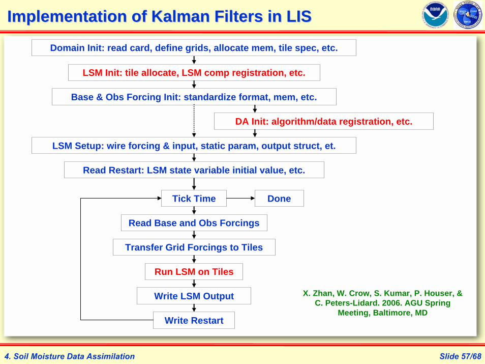
Implementation of Kalman Filters in LISImplementation of Kalman Filters in LIS
Domain Init: read card, define grids, allocate mem, tile spec, etc.
LSM Init: tile allocate, LSM comp registration, etc.
Base & Obs Forcing Init: standardize format, mem, etc.
LSM Setup: wire forcing & input, static param, output struct, et.
Read Restart: LSM state variable initial value, etc.
Read Base and Obs Forcings
Transfer Grid Forcings to Tiles
Tick Time
Run LSM on Tiles
Write LSM Output
Write Restart
DA Init: algorithm/data registration, etc.
Done
X. Zhan, W. Crow, S. Kumar, P. Houser, & C. Peters-Lidard. 2006. AGU Spring
Meeting, Baltimore, MD
4. Soil Moisture Data Assimilation

Slide 58/68
Data Assimilation Setups in Data Assimilation Setups in lis.crdlis.crd FileFile
&data_assimilationLIS%a%DAALG = 3 ! 0-no,1-di,2-ekf,3-enkf da methodLIS%a%DAOBS = 2 ! 0-no,1-tmi_sm,2-syn_sm,3-amsre_sm, …LIS%a%DAVAR = 1 ! 0-no,1-sm,2-ts,LIS%a%NSTV = 16 ! # of LSM state variablesLIS%a%NDAV = 4 ! # of prog model vars to be assimilatedLIS%a%NENS = 10 ! number of ensemble members for EnKFLIS%a%RENSEM= 0 ! write ensember data into files (0-n,1-y)LIS%a%fvlfn = "./data/perturb/f_mos.dat" ! forc perturb’nsLIS%a%svlfn = "./data/perturb/s_mos.dat" ! stat perturb’ns/
&soil_moisture_dasmobsdir = "./data/NOAHSoilMoist1_NLDAS" ! data locationnob = 1 ! # of obs vars (e.g. surface sm)oer = 0.01 ! obs error rateMer = 0.03 ! Mdl error rate/
4. Soil Moisture Data Assimilation

Slide 59/68
EnKFEnKF Assimilation of Synthetic SM Data in LISAssimilation of Synthetic SM Data in LISN
oah
Mos
aic
LSM Run Synthetic Obs EnKF Assimilation
X. Zhan, W. Crow, S. Kumar, P. Houser, & C. Peters-Lidard. 2006. AGU Spring Meeting, Baltimore, MD
4. Soil Moisture Data Assimilation
Test LIS-KF with Synthetic SM Data

Slide 60/68
EnKFEnKF Assimilation of AMSRAssimilation of AMSR--E SM Data in LISE SM Data in LIS
Scaled AMSR-E EnKF Assimilation
AMSR-E SM
Noah LSM Run
EnKF Assimilation
X. Zhan, W. Crow, S. Kumar, P. Houser, & C. Peters-Lidard. 2006. AGU Spring Meeting, Baltimore, MD
4. Soil Moisture Data Assimilation
Test LIS-KF with AMSR-E SM Data

Slide 61/68
Impact of Impact of ObsObs Data Preprocessing on Data Preprocessing on EnKFEnKF DADA
4. Soil Moisture Data Assimilation
CDF Matching Impact with Synthetic SM Data
Zhan, X., et al. 2007. AMS
Annual Meeting, San Antonio, TX

Slide 62/684. Soil Moisture Data Assimilation
CDF Matching Impact on EnKF DA (1)
Impact of Impact of ObsObs Data Preprocessing on Data Preprocessing on EnKFEnKF DADA

Slide 63/684. Soil Moisture Data Assimilation
CDF Matching Impact on EnKF DA (2)
Impact of Impact of ObsObs Data Preprocessing on Data Preprocessing on EnKFEnKF DADA

Slide 64/684. Soil Moisture Data Assimilation
CDF Matching Impact on EnKF DA (3)
Impact of Impact of ObsObs Data Preprocessing on Data Preprocessing on EnKFEnKF DADA

Slide 65/684. Soil Moisture Data Assimilation
CDF Matching Impact on EnKF DA (4)
Impact of Impact of ObsObs Data Preprocessing on Data Preprocessing on EnKFEnKF DADA

Slide 66/68
SM Data Research PlanSM Data Research Plan
Bayesian Merging Method
Cubist
Low Rez Soil Moisture
Data
High Rez Soil Moisture
Proxy
SMMR/SSMI/TMI/AMSR-E/Windsat/
SMOS/CMIS MW Obs
TM/AVHRR/MODIS/VIIRSSW/IR Obs
Radar ObsCRTM
Land EM
Soil Moisture Ground Obs
MeterologicalForcing & Land
Surface Obs
LIS Data Assimilation
Agriculture DSS
Drought Monitoring/
Forecast
Flood Monitoring/
Forecast
Military Applications
Water Resources
Management
Numerical Weather
Predictions
High Rez/Quality
Soil Moisture Data
Products
GOES Obs
5. SM Data Research Plan

Slide 67/68NOAA-NESDIS-STAR, Science Forum, April 20, 2007
1. SM Data & Importance
SUMMARY
Slide 67/68
NWP & Climate/Hydro Predictions,Water/energy/carbon studies,Agricultural Effeciencies,Military mobility, Water resources management.
2. SM Observation Techniques
Microwave satellite remote sensing (radiometer/radar) is the most efficient approach for global or regional soil moisture mapping.
3. MW Soil Moisture Retrievals
Global soil moisture data products are created from radiometer and scatterometer, but retrieval algorithms need improvement;
Radar observations of soil moisture require more testing and studies.
4. Soil Moisture Data Assimilation
Ensemble Kalman filter has been tested in LIS, but more studies are need for use in GFS;
More examination is needed for using Noah LSM to assimilate land satellite observations with Kalman filters.
5. SM Data Research Plan
Many research opportunities exist to improve accuracy and resolution of soil moisture data products and to broad their applications.

Slide 68/68
The END