scc & leica import total station survey, gps, traverse, levelling and gis data direct from all...
TRANSCRIPT

SCC & Leica Import total station survey, GPS, traverse,
levelling and GIS data direct from all Leica instruments.
In built Grid Inquest for GPS reduction to ITM
Pre-built libraries for a range of tasks (including rivers, rails, tunnelling, QBN works and check surveys, and utility / GIS surveys)
Upload of setting out and geometric design information
Combine support for conventional instruments with scan laser machine control , Amberg trolley, and scan data
Automatic creation of fully annotated 3d models to the highest standards
Creation of sections and profiles, with extensive river sections functionality.
Volume calculations and optimization Design for road, rail, and sites with 3d
visualisation, visual intrusion analysis Open reporting with an extensive range of
fully customisable reports.
www.atlascomputes.ie

Traverse and network adjustment
• Full 2d and 3d least squares network adjustment and simple Bowditch traverse adjustments
• Absolute and relative error ellipses• Coordinate and observation
constraints• Plotting of fully annotated network
diagram• Pre-defined and fully customisable
reports, including support for station location diagrams and photography, and client logos and details
• Wide range of 2d and 3d local and geodetic transformations
• Export all or selected information to Excel, Word, PDF and many other formats
www.atlascomputes.ie

• High speed surface modelling engine with capacity for multi-million point models
• Extensive interactive 3d editing tools including trim, extend, fillet, cut & paste and many more
• Cartographic quality output to all major CAD, GIS and publishing systems
• Numerous productivity tools, including 2d drawing to 3d model conversion, extraction of elevations from plans, model revision comparison, etc…
• 3d visualisation with automatic placement of street furniture, road markings, vegetation, overhead and underground features
MODEL CREATION AND EDITING
www.atlascomputes.ie

Sections
• Long sections and cross sections from survey strings, using the cursor, and relative to alignments
• Cut, paste and project plan detail onto sections
• Automated creation of complex river sections from survey
• Extensive section editing and annotation tools
• Comprehensive sheet layout tools, with export to CAD, PDF and reports
www.atlascomputes.ie
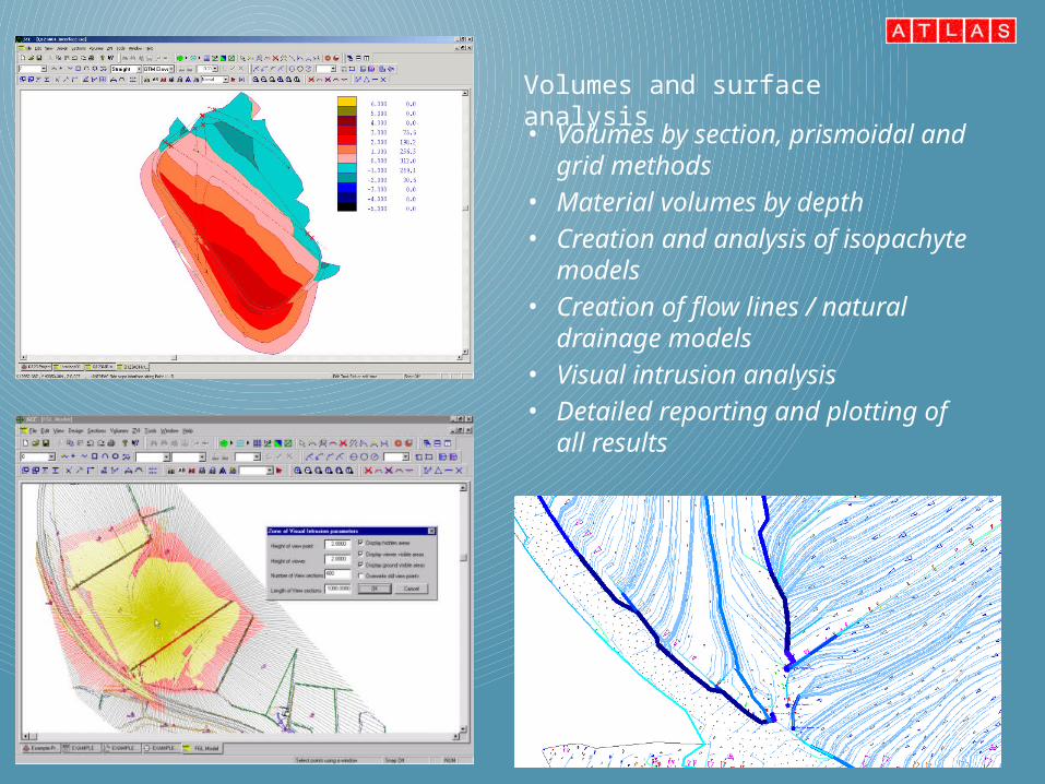
• Volumes by section, prismoidal and grid methods
• Material volumes by depth• Creation and analysis of
isopachyte models• Creation of flow lines / natural
drainage models• Visual intrusion analysis• Detailed reporting and plotting
of all results
Volumes and surface analysis

• Import and export horizontal, vertical and section template design data from Bentley MX, LandXML and CAD formats
• Interactive alignment creation and editing tools
• Generate and model complex side slopes
• Check survey computation and reporting
• Rail surveying tools for checking cant, gauge, lift and slue
• Wriggle survey processing for tunnelling
• Volume optimizer including cut & fill balancing and cut minimization
Design and QA
www.atlascomputes.ie

PocketDTM• Stream lined field data
collection for SCC• Supported on a wide variety
of tablet and hand held devices
• Suitable for topographic survey, map updating, setting out, levelling, control surveys, asset surveying, GIS data capture, volume analysis and QA
• Connects to a wide variety survey equipment including total stations, RTK and NRTK GPS, and electronic levels
• Communicate with head office via 3G and GPRS technology
www.atlascomputes.ie

Map updating and checking• Import background maps from CAD, GIS and design packages via
DWG, DGN, SHP, GENIO and LandXML formats• See your edits and your position on the map as you survey• Collect GIS data fields and photography at the same time as
conventional survey data
• Combine GPS and total station observations in the same job
• Collect hidden or difficult to reach points using tape measurement, distance intersection and/or offsets from map data
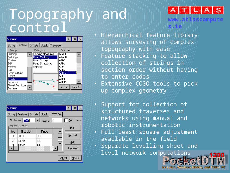
Topography and control• Hierarchical feature library allows
surveying of complex topography with ease
• Feature stacking to allow collection of strings in section order without having to enter codes
• Extensive COGO tools to pick up complex geometry
• Support for collection of structured traverses and networks using manual and robotic instrumentation
• Full least square adjustment available in the field
• Separate levelling sheet and level network computations
www.atlascomputes.ie

Setting out for plan, road and rail
• Set out plan coordinates or road or rail geometry using total station or GPS, including robotic support
• Check existing work and report as-built using design comparisons
• Import multiple DTMs for continuous 3d reference surfaces
• Import horizontal and vertical alignments from Bentley MX and LandXML for real time chainage and offset
• Create setting out information from plans or by cutting sections through the design on the fly